AMERICAN ELECTRIC POWER (SWEPCO)
|
|
|
- Roxanne Barker
- 5 years ago
- Views:
Transcription


1
2 2016 DAM & DIKE INSPECTION REPORT ASH PONDS GERS WELSH POWER PLANT AMERICAN ELECTRIC POWER (SWEPCO) CASON, TEXAS NATIONAL INVENTORY NO. TX4357 PREPARED BY GEOTECHNICAL ENGINEERING AEP SERVICE CORPORATION 1 RIVERSIDE PLAZA COLUMBUS, OHIO December 2016
3 ANNUAL DAM AND DIKE INSPECTION REPORT WELSH POWER PLANT ASH STORAGE PONDS YEAR 2016 GERS INTRODUCTION Background Information Facility Location Description Description of Primary Ash Pond CCR Unit Embankment Configuration Area, Capacity and Depth Data Construction and Operational History Surface Water Control Background Information Facility Location Description Description of Bottom Ash Storage Pond CCR Unit Embankment Configuration Area, Capacity and Depth Data Construction and Operational History Surface Water Control... 5 SUMMARY OF VISUAL OBSERVATIONS... 6 Primary Ash Pond... 6 Bottom Ash Storage Pond... 7 REVIEW OF AVAILABLE INFORMATION... 7 ASSESSMENT OF RECENT INSTRUMENTATION DATA... 7 CONCLUSIONS... 8 RECOMMENDATIONS... 8 REMEDIAL ACTIONS... 8 GENERAL MAINTENANCE AND MONITORING... 9 APPENDIX A: APPENDIX B: VICINITY MAP AND PLAN VIEW INSPECTION PHOTOGRAPHS
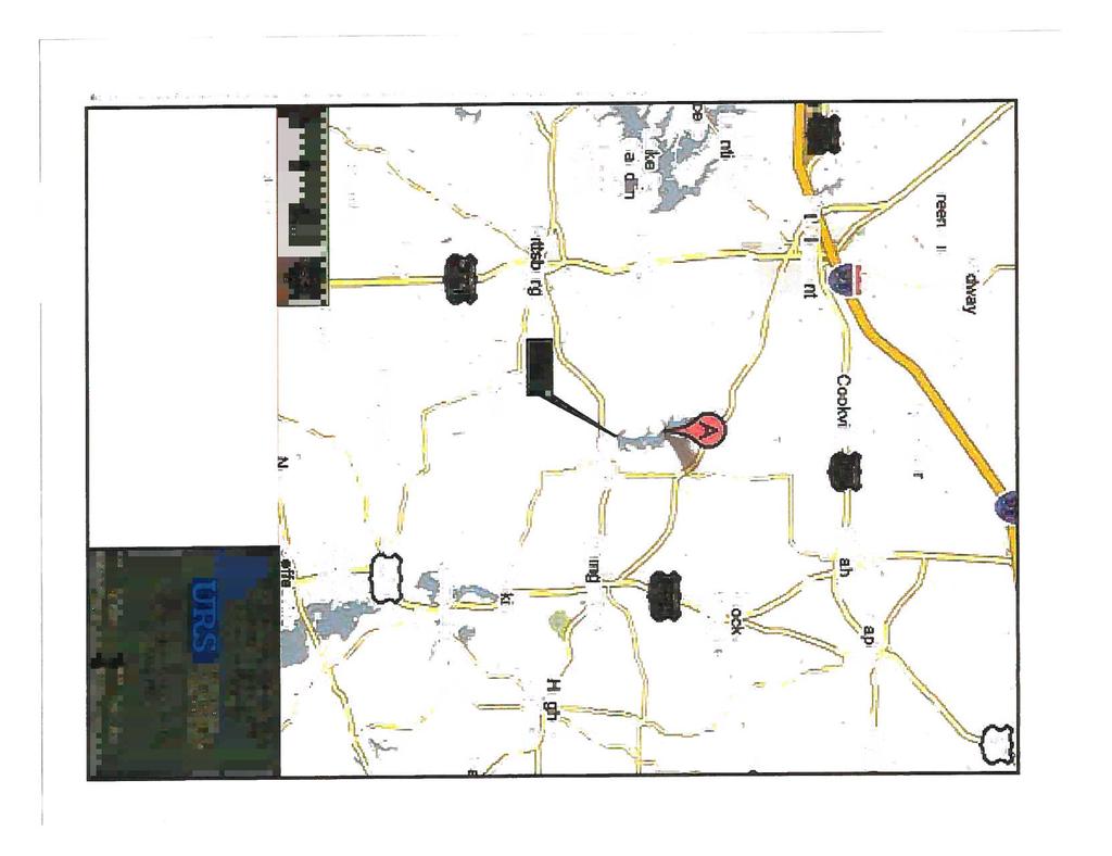
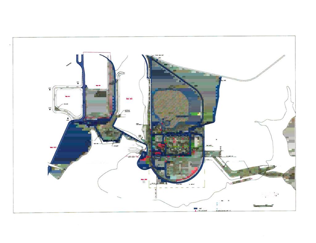
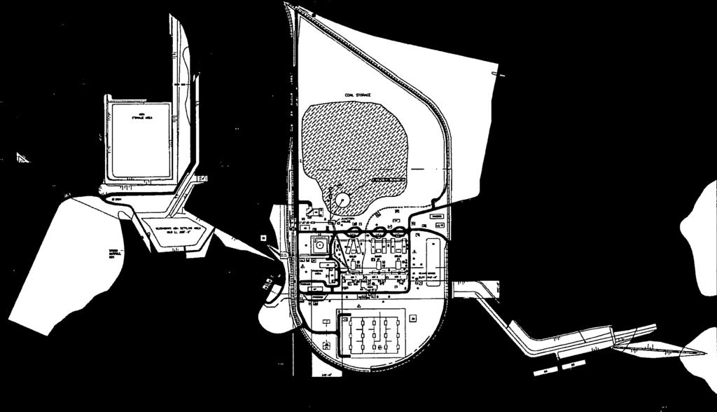
4 INTRODUCTION AEPSC (American Electric Power Service Corporation) Civil Engineering manages the Dam Inspection and Maintenance Program (DIMP) at AEP facilities. As part of the DIMP, staff from the Geotechnical Engineering Section conducts dam and dike inspections annually. The 2016 inspection of Designated CCR Surface Impoundments at the Welsh Power Plant were performed by Mr. Brett A. Dreger, P.E. and Mr. William G. Carter, P.E. This report was prepared by Mr. Brett A. Dreger, P.E. and serves as a summary of the inspection and an assessment of the general conditions of the facility. Mr. William G. Carter, P.E. of AEP Plant Engineering Region 5, was the facility contact for the inspection. The inspection was performed on November 2, Weather conditions were mostly sunny, with temperatures ranging from 70 F in the morning to 84 F in the afternoon. General Information: 1. Background Information The following section provides background information for the AEP J. Robert Welsh Generating Plant primary ash pond. 1.1 Facility Location Description The AEP J. Robert Welsh Plant is located in southern Titus County, approximately 8 miles northeast of Pittsburg, Texas, and approximately two miles northwest of Cason, Texas. The primary ash pond CCR unit is located southwest of the Plant and directly west of the Welsh Reservoir (Appendix A). 1.2 Description of Primary Ash Pond CCR Unit The following section will discuss the embankment configuration, area, volume, construction and operational history, and surface water control associated with the primary ash pond Embankment Configuration The primary ash pond was placed into operation in 1977, and is located in a topographically low area that had been an unnamed intermittent tributary of Swauano Creek prior to development of the Site. The primary ash pond is bounded by natural ground surface (topographically higher areas) to the north and west, and embankment dikes to the south and east. The elevation at the top of embankment along the crest area is approximately feet above msl and the toe elevation of the embankment is approximately feet above msl. The downstream slope of the primary ash pond embankment is inundated by the cooling lake reservoir (Normal Lake Level = feet above msl). These dikes are Page 1 of 9
5 predominantly constructed of compacted sandy clay and clayey sand. The embankment dike south of the primary ash pond includes a drainage canal that receives overflow (clear) water from the primary ash pond. The water level in the primary ash pond is controlled by a weir box which discharges into the drainage canal. The clear water in the drainage canal flows east and discharges into the clear water pond. The primary ash pond embankment is approximately 40 feet in height Area, Capacity and Depth Data The bottom elevation of the Primary Ash Pond is 300 feet above mean sea level (above msl), the normal high water level is at elevation and the emergency spillway crest is set at feet above msl. The storage capacity of the primary ash pond at elevation feet above msl is acre-ft. Table: Pond Complex Capacity and Depth Data Approximate Minimum depth of impounded water since last annual inspection Approximate Maximum depth of impounded water since last annual inspection Approximate Present depth of impounded water at the time of the inspection Approximate Minimum depth of CCR since last annual inspection Approximate Maximum depth of CCR since last annual inspection Approximate Present depth of CCR at the time of the inspection Primary Ash Pond 32.1ft (332.1) 34.9ft (334.90) 32.1ft (332.10) 10.0ft (310.0) 33ft (333.0) 33.0ft (333.0) Storage Capacity of impounding structure at the time of the inspection Approximate volume of impounded water at the time of the inspection Approximate volume of CCR at the time of the inspection acre-ft acre-ft 22 acre-ft Construction and Operational History The AEP J. Robert Welsh Plant began operations in 1977 with three coal-fired generating units (Units 1, 2, and 3). Throughout the life of the generating plant, CCR materials (fly ash, bottom ash, economizer ash) have been generated. All of these byproducts were stored in either the primary ash pond or in the adjacent landfill that was constructed about In 2000, the 22-acre bottom ash storage pond was installed south of the landfill. The bottom Page 2 of 9
6 ash storage pond was constructed with a 60-millimeter (mil) high-density polyethylene (HDPE) liner, and receives bottom ash and economizer ash dredged from the primary ash pond via sluiced pipes. Presently, economizer ash from the generating plant is sluiced to the primary ash pond. On occasion, bottom ash is sluiced to the primary ash pond. The solids settle out in the pond and the clear liquids flow through a drainage canal into the clear water pond (a non-ccr Unit). Water in the clear water pond discharges through a weir box into a 36-inch-diameter pipe, and then into the Welsh Reservoir under Texas Pollutant Discharge Elimination System (TPDES) Permit No. WQ Surface Water Control Surface water flow within the primary ash pond complex is controlled by a weir and emergency spillway located on the south side of the pond below the embankments. The pond elevation is maintained so that surface water flows through the weir box which has a bottom elevation of 325 feet above msl. The emergency spillway is 90 feet wide with a crest elevation of 334 feet above msl. Clear water flows through the weir (and occasionally the emergency spillway during heavy precipitation events) into a drainage canal along the south side of the pond. The drainage canal discharges into the clear water pond located directly southeast of the primary ash pond. The perimeter embankments on the south and east sides of the primary ash pond are located at an approximate elevation of 340 feet above msl. Therefore the perimeter embankments have approximately six feet of freeboard above the emergency spillway. 2. Background Information The following section provides background information for the AEP J. Robert Welsh Generating Plant Bottom Ash Storage Pond. 2.1 Facility Location Description The AEP J. Robert Welsh Plant is located in southern Titus County, approximately 8 miles northeast of Pittsburg, Texas, and approximately two miles northwest of Cason, Texas. The Bottom Ash Storage Pond CCR unit is located at the south end of the Plant and approximately 1,000 feet west of the Welsh Reservoir (Appendix A). 2.2 Description of Bottom Ash Storage Pond CCR Unit The following section will discuss the embankment configuration, area, volume, construction and operational history, and surface water control associated with the Bottom Ash Storage Pond. Page 3 of 9
7 2.2.1 Embankment Configuration The Bottom Ash Storage Pond was placed into operation in 2000, and is located in a topographically high area of the Plant. The Bottom Ash Storage Pond embankments are approximately 20 feet in height and are constructed of compacted clay on a 3:1 slope (3 feet horizontal, 1 foot vertical). The elevation at the base of the embankment is approximately 340 feet above msl, and the elevation at the top of the embankment around the perimeter of the Bottom Ash Storage Pond is approximately 360 feet above msl Area, Capacity and Depth Data The Bottom Ash Storage Pond is approximately 22 acres in size. The principal spillway for the Bottom Ash Storage Pond is located near the southeast corner of the pond and consists primarily of an 18 inch drain at elevation feet above msl and also of a 40-foot-long broad-crested weir with a crest elevation of 355 feet above msl. The emergency spillway is an 8-foot-wide weir with a rock rip-rap discharge chute located along the southern embankment at an elevation of 358 feet above msl. The storage capacity of the Bottom Ash Storage Pond at elevation 358 feet above msl is approximately acre-ft. Table: Pond Complex Capacity and Depth Data Bottom Ash Storage Approximate Minimum depth of impounded water since last annual inspection Approximate Maximum depth of impounded water since last annual inspection Approximate Present depth of impounded water at the time of the inspection Approximate Minimum depth of CCR since last annual inspection Approximate Maximum depth of CCR since last annual inspection Approximate Present depth of CCR at the time of the inspection Pond 10.5ft (350.5) 11.0ft (351.0) 1.0ft (349.0) 10.5ft (350.5) 18.0ft (358.0) 18.0ft (358.0) \ Storage Capacity of impounding structure at the time of the inspection Approximate volume of impounded water at the time of the inspection Approximate volume of CCR at the time of the inspection acre-ft 5 acre-ft 224 acre-ft Page 4 of 9
8 2.2.3 Construction and Operational History The AEP J. Robert Welsh Plant began operations in approximately 1977 with three coalfired generating units (Units 1, 2, and 3). Throughout the life of the generating plant, CCR materials (fly ash, bottom ash, economizer ash) have been generated. All of these byproducts were stored either in the primary ash pond or in the adjacent landfill that was constructed in the late 1970 s. In 2000, the 22-acre Bottom Ash Storage Pond was installed south of the landfill. The Bottom Ash Storage Pond receives bottom ash and economizer ash dredged and sluiced from the primary ash pond. The Bottom Ash Storage Pond contains a 60-millimeter (mil) high-density polyethylene (HDPE) liner. The liner is located at the base of the Bottom Ash Storage Pond at an elevation of 340 feet above msl. The liner also extends along the base of the Bottom Ash Storage Pond sidewalls and is keyed into the top of the Bottom Ash Storage Pond earthen embankment at an elevation of 360 feet above msl. The southeast corner of the Bottom Ash Storage Pond contains an approximate ¼-acre clear water pond with a base elevation of 347 feet above msl. The clear water pond receives clear water primarily through an 18 inch drain and then through an overflow structure from the main part of the Bottom Ash Storage Pond through the 40-foot-long broad-crested weir discussed above in Section Water in the ¼-acre clear water pond at the southeast corner of the Bottom Ash Storage Pond discharges through a 30-inch-diameter pipe into the primary ash pond system Surface Water Control Surface water flow within the Bottom Ash Storage Pond is primarily controlled by an 18 inch drain and then by a weir located on the southeast side of the pond below the embankments. The pond elevation is maintained so that surface water flows through the drain pipe at invert elevation feet above msl or weir which has a crest elevation of 355 feet above msl. Clear water flows through the weir into the ¼-acre clear water pond at the southeast corner of the Bottom Ash Storage Pond, then discharges through a 30-inch diameter pipe into the primary ash pond. The emergency spillway for the Bottom Ash Storage Pond is located along the southern embankment, and is 8 feet wide with a crest elevation of 358 feet above msl. The perimeter embankments of the Bottom Ash Storage Pond are located at an elevation of 360 feet above msl. Therefore the perimeter embankments have approximately five feet of freeboard above the clear water discharge weir, and approximately two feet of freeboard above the emergency spillway. Page 5 of 9
9 SUMMARY OF VISUAL OBSERVATIONS The summary of the visual observations presented herein uses terms to describe the general appearance or condition of an observed item, activity or structure. Their meaning is understood as follows: Good: Fair or satisfactory: Poor: Minor: Significant: Excessive: A condition or activity that is generally better or slightly better than what is minimally expected or anticipated from a design or maintenance point of view. A condition or activity that generally meets what is minimally expected or anticipated from a design or maintenance point of view. A condition or activity that is generally below what is minimally expected or anticipated from a design or maintenance point of view. A reference to an observed item (e.g., erosion, seepage, vegetation, cracks, concrete surface etc.) where the current maintenance condition is below what is normal or desired, but which is not currently causing concern from a structure safety or stability point of view. A reference to an observed item (e.g. erosion, seepage, vegetation, cracks, concrete surface etc.) where the current maintenance program has neglected to improve the condition. Usually, conditions that have been identified in previous inspections, but have not been corrected. A reference to an observed item (e.g., erosion, seepage, vegetation, cracks, concrete surface etc.) where the current maintenance condition is above or worse than what is normal or desired, and which may have affected the ability of the observer to properly evaluate the structure or particular area being observed or which may be a concern from a structure safety or stability point of view. Results of the visual inspection performed on November 2, 2016 are summarized below. Pond water elevation is presented in the instrumentation data section of this report. Primary Ash Pond At the time of inspection the primary ash pond was in service and the current pool elevation was approximately feet above msl. The dikes of the primary ash pond are generally in fair condition with overgrown vegetation on the downstream side and an abundance of woody vegetation growing out of the riprap on the lower portion of the slope. The vegetation was so thick on the lower downstream slope, that it was difficult to access and visually inspect. There were no observed signs of slope displacement, erosion, or seepage. The crest was in good condition with no observed cracking, misalignment, or significant deformation (Photographs Nos. 1, 2, and No. 3). The emergency spillway area Page 6 of 9
10 for the primary pond was in fair and functional condition, but also displayed overgrown vegetation (Photograph No. 4). The primary pond discharge canal overflow weir was in satisfactory condition (Photograph No. 5). Bottom Ash Storage Pond At the time of inspection the bottom ash storage pond was in service and the current pool elevation is approximately feet above msl. The Bottom Ash Storage Pond exterior slopes were satisfactory condition with no observed sign of slope displacement, erosion or seepage. The slopes were well maintained with controlled vegetation; however, there were a few isolated areas with signs of animal borrow (Photograph No. 6, 7, 8, 9 and No. 10). The emergency spillway section of the pond appeared to be fair and functional condition (Photograph No. 10). The interior area of the pond is lined with white HDPE geomembrane, and there were no observed issues with the crest or interior slopes (Photograph No. 11 and No. 12). The only observation noted during the inspection is the clear water overflow basin on the interior of the pond was filled with ash material up to the invert elevations of both the inlet and outlet pipes (Photograph No. 13). REVIEW OF AVAILABLE INFORMATION A review of available information regarding the status and condition of the Ash Ponds, which include files available in the operating record, such as design and construction information, previous periodic structural stability assessments, previous 7 day inspection reports, previous 30-day instrumentation data, and previous annual inspections has been conducted. Based on the review of the data there were no signs of actual or potential structural weakness or adverse conditions. ASSESSMENT OF RECENT INSTRUMENTATION DATA The monitoring instrumentation for the Primary Ash Pond consists of the following: one (1) active piezometer located through the main embankment area. Monitoring instrumentation data is collected as part of the annual inspection program for the Primary Ash Pond. The piezometer level measured during the inspection is provided below. Pond Crest Elevation Boring/Piezometer Water Level Name msl 11/02/2016 msl Primary Ash Pond B A review of the active piezometer readings indicates that the static water level readings are consistent from month to month. Page 7 of 9
11 CONCLUSIONS Based on the visual inspection, the overall condition of the dams and levees of the Ash Pond Complex is in satisfactory and functional condition. Inspection and monitoring activities being performed by the Plant and AEPSC Civil Engineering & Geotechnical Services should continue. Specific conclusions related to this inspection include: There is no evidence of distress that would indicate the possibility of immediate sliding, slope instability, settlement, misalignment or cracking of the bottom ash pond embankments. As such it is concluded that the dam and dikes are performing as designed. Overall, the slope conditions of the dam and levees are generally fair with the exception of animal burrow activity on the bottom ash storage pond. These areas overtime can lead to significant erosion and stability problems. Vegetation management for the facilities is considered satisfactory. Some areas are overgrown and should be managed accordingly, however, there are a few areas that have sparse vegetation. RECOMMENDATIONS Following are remedial actions, general maintenance items and monitoring requirements that are recommended as a result of the inspection. Assistance or guidance with the implementation of these items can be provided by AEPSC Civil Engineering & Geotechnical Services: REMEDIAL ACTIONS The overgrown vegetation on the downstream slope of the primary ash pond embankment needs to be controlled. Overgrown areas need to be mowed on a regular basis and areas of sparse vegetation need to be reseeded and fertilized in order to establish adequate cover on both the interior and the exterior side slopes. Page 8 of 9
12 GENERAL MAINTENANCE AND MONITORING Any erosion gullies, slough areas (shallow slides), and gopher disturbed areas that are encountered should be stabilized as soon as possible. Erosion gullies and slough areas may be stabilized by redressing the slope and placing rip rap or re-vegetating, depending on the slope gradients and propensity for concentrated water flow. Gopher damaged areas should be redressed in the same fashion; A maintenance program of seeding, fertilizing and mulching the slopes of the dam and levees should be implemented. Establishing local grass varieties will prevent erosion and could improve stability of slopes. The local U. S. Dept. of Agriculture Natural Resource Conservation Service (NRCS) office can provide suitable seed mix design for the local climate and soils; The slopes of the ash pond dikes should be maintained free of brush and woody vegetation; Monitoring procedures and maintenance activities should be implemented in coordination with AEP Geotechnical Engineering; Continue Plant inspections of the facility in accordance with the Circular Letter and CCR Rules. Based on the inspection and review of relevant documents, AEPSC Civil Engineering believes that the Welsh Primary Ash Pond and the Bottom Ash Storage Area have a general satisfactory appearance and are in satisfactory condition. Inspections and monitoring should continue. If you have any questions with regard to this report, please do not hesitate to contact Brett A. Dreger at (614) (Audinet ). Page 9 of 9
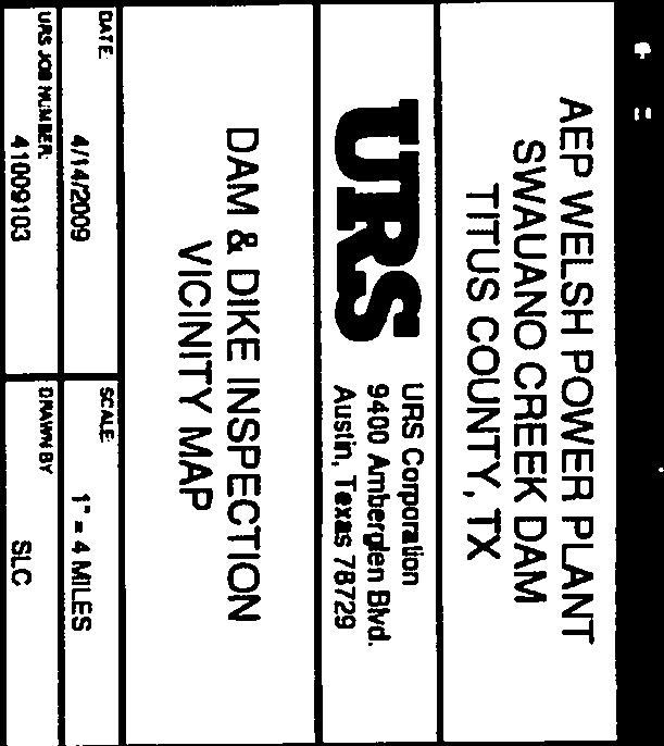
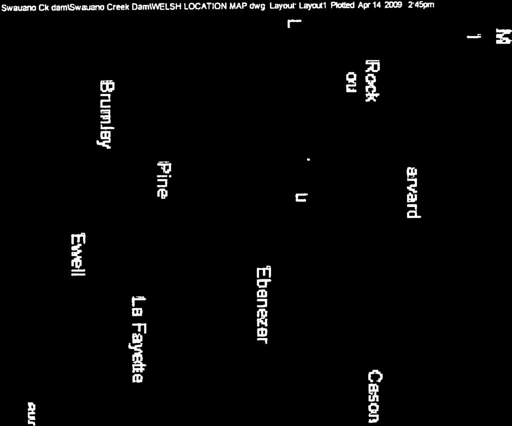
13 APPENDIX A VICINITY MAP AND PLAN VIEW


14


15
16 APPENDIX B INSPECTION PHOTOGRAPHS


17 November 2, 2016 Welsh Power Plant Dam and Dike Inspections Page 1 Photo # 1 Typical view of primary ash pond upstream slope and interior conditions. Photo # 2 Typical view of primary ash pond downstream slope. Photo # 3 Typical crest area of primary ash pond.


18 November 2, 2016 Welsh Power Plant Dam and Dike Inspections Page 2 Photo # 4 Emergency spillway channel of primary ash pond. Photo # 5 Primary Ash Pond Discharge Canal Concrete Weir Box. Photo # 6 Active ash storage area (Winston Pond) downstream slope southeast area.


")
19 November 2, 2016 Welsh Power Plant Dam and Dike Inspections Page 3 Photo # 7 Active ash storage area (Winston Pond) downstream slope southeast area. Photo # 8 Active ash storage area (Winston Pond) downstream slope south area. Photo # 9 Active ash storage area (Winston Pond) downstream slope west area.


20 November 2, 2016 Welsh Power Plant Dam and Dike Inspections Page 4 Photo # 10 Active ash storage area (Winston Pond) downstream slope looking at emergency spillway channel. Photo # 11 Active ash storage area (Winston Pond) looking at typical interior conditions. Photo # 12 Active ash storage area (Winston Pond) looking at typical interior conditions.
 interior clear water pool looking north.")
21 November 2, 2016 Welsh Power Plant Dam and Dike Inspections Page 5 Photo # 13 Active ash storage area (Winston Pond) interior clear water pool looking north.