Project Scoping Meeting Thousand Palms Flood Control Project EIR/EIS
|
|
|
- Aldous Mason
- 5 years ago
- Views:
Transcription

1 Project Scoping Meeting Thousand Palms Flood Control Project EIR/EIS Thousand Palms Community Center December 6, :00 p.m. Coachella Valley Water District
2 Meeting Agenda Introductions CEQA Lead Agency: Coachella Valley Water District NEPA Lead Agency: United States Army Corps of Engineers Overview of the Proposed Project Project History Existing Flood Hazards Environmental Review Process Public Comment Period
3 Purpose of a Scoping Meeting Provide information on the Project Describe environmental review process Identify any potential issues Solicit input on environmental topics, project alternatives, and mitigation Ensure all relevant issues are addressed
4 Public Comments Comments will be taken after the presentation Please complete speaker card; each speaker will be announced Please limit comments to 3 minutes You may provide written comment up to 12/19/16 Future comment opportunities as well
5 Acronyms CVWD: Coachella Valley Water District USACE: United States Army Corps of Engineers CEQA: California Environmental Quality Act NEPA: National Environmental Policy Act EIR: Environmental Impact Report EIS: Environmental Impact Statement FEMA: Federal Emergency Management Agency MSHCP: Multiple Species Habitat Conservation Plan
6 CVWD s Purpose & Need of the Project Provide Flood Protection Protect approximately 2,800 acres from flooding Sand Dune Habitat Preservation Coachella Valley Preserve and Wildlife Refuge CVMSHCP Boundary Modification Define the southern boundary of the Coachella Valley Preserve


7 U.S. Army Corps of Engineers - Army Corps of Engineers Role and Responsibilities Thousand Palms Flood Control Project US Army Corps of Engineers BUILDING STRONG
8 USACE s General Overview Corps of Engineers is divided into many programs Civil Works - most familiar; construct levees, dams, military installations, etc. Regulatory - issue permits to private and public entities for impacts to waters and wetlands. Jurisdiction under Section 404 of the Clean Water Act Protect the biological, physical and chemical integrity of nation s waters Review project design and assess project impacts to biological resources, endangered species, historic and cultural properties, Tribal concerns (plus public interest factors) Corps Regulatory is one of several agencies involved Regional Water Quality Control Board, California Dept. of Fish and Wildlife, U.S. Fish and Wildlife Service, local agencies, etc. BUILDING STRONG And Taking Care Of People!
9 USACE s Role and Responsibilities Federal permit = comply with National Environmental Policy Act (NEPA) Public involvement and disclosure Look at alternatives to project Conduct public interest review Economics, general environmental concerns, fish and wildlife values, flood hazards, water quality, safety, etc. Corps has determined the project may have a significant effect Environmental Impact Statement (EIS) BUILDING STRONG And Taking Care Of People!
 Publish draft EIS (~earliest would")

10 USACE s EIS procedures Corps receives a permit application Scoping process begins: Public Notice with ~30-60 day comment period Comment period closes December 19, 2016 Conduct a public scoping meeting (today) Publish draft EIS (~earliest would be end of 2017) Public Notice with 45 day comment period Public hearing or meeting (optional) Publish final EIS Public Notice with 30 day comment period Permit issued, issued with modifications, or denied BUILDING STRONG And Taking Care Of People!
11 This Project has some history! : Feasibility study completed by USACE 2000: Congress authorized the project : Project Design 40% completed Environmental Analysis Conducted 2012: CVWD and USACE assume lead role in design / environmental / construction 2014: Federal Scoping Meeting Conducted Present Time: Refine Project and Scoping Period
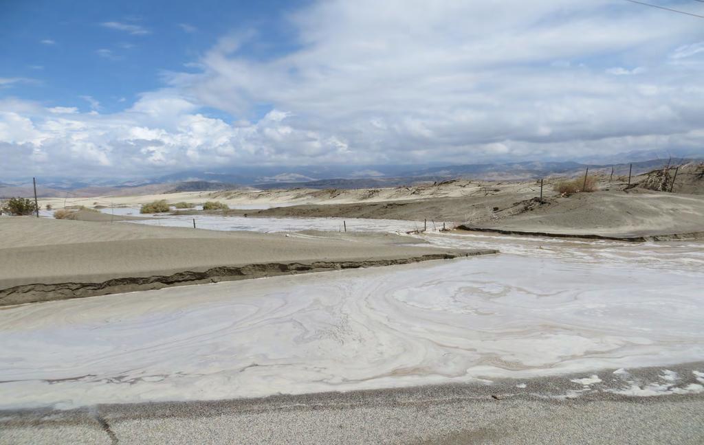
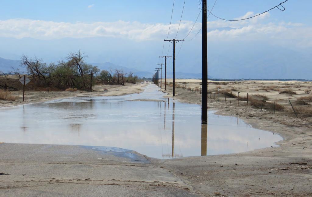
12 Existing Physical Setting Project area is prone to flooding during intense winter storms Steep terrain and large watersheds funnel water to the project area Storms can form quickly with little warning for evacuation Moderate to large floods have occurred in 1909, 1927, 1938, 1940, 1943, 1965, 1969, 1978, 1980, 1983, and Storms within the last 5 years have also resulted in localized flooding below the proposed reaches.
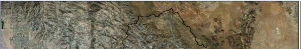
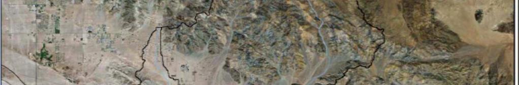
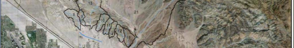
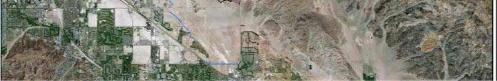
13 Watersheds

14 Flood Video

15 North of Xavier HS

16 North of Xavier HS

17 East of Xavier HS

18 North of Classic Club

19 North of Classic Club

20 North of Classic Club

21 North of Classic Club
22 Avenue 38
23 Avenue 38

24 Ramon Road East of Monterey

25 Ramon Road & Varner

26 Ramon Road & Varner

27 Flood Map Existing Conditions

28 Proposed Project (Alternative 1) The Project alignment will define the southern edge of the CVMSHCP Conservation Area

29 Flood Map with Project Implementation
30 Key Project Components Reach 1: 2.4-mile levee; 5-14 feet high Reach 2: 0.32-mile levee; 5 feet high Reach 3: 1.2-mile levee; 5-14 feet high; 1.0-mile channel Reach 4: 2.0-mile incised trapezoidal channel Realignment of Avenue 38 and minor modification to Washington Street
31 Levee Height Key Design Features Designed for 100-year flood + 4 feet min. Constructed from soil cement Mixture of native soil and concrete Has a natural look Construct Road Crossings Desert Moon Dr. and Via Las Palmas Connect to existing drainage features Classic Club Golf Course, Del Webb/Sun City
32 Typical Levee and Channel Sections
33 The Project alignment will define the southern edge of the CVMSHCP Conservation Area
34 The Project alignment will define the southern edge of the CVMSHCP Conservation Area
35 The Project alignment will define the southern edge of the CVMSHCP Conservation Area
36 Potential Alternatives Alternative 2: Removal of Reach 2 All other project components would be the same as the proposed project Alternative 3: Modified Reach 3 Reach 3 tilted west/southwest from 6 to 10 degrees Reach 3 tilted west/southwest 17 degrees All other project components would be the same as the proposed project Alternative 4: No Action Alternative Project not constructed

37 Alternative 2 The Project alignment will define the southern edge of the CVMSHCP Conservation Area
38 Alternative 3 The Project alignment will define the southern edge of the CVMSHCP Conservation Area
39 Objective of Environmental Review Identify significant issues Assess potential impacts Identify ways to avoid or reduce impacts Disclose information about environmental impacts Include public participation at various stages Provide environmental information to decision makers at the CVWD and USACE Decision makers will consider a range of factors in rendering their decisions, not just environmental factors The EIR/EIS does not make any recommendations for approving or denying the proposed project
40 What are the next steps? Public Input Scoping Meeting Public Input Opportunity Notice of Preparation & Notice of Intent Assess Comments, Prepare Studies & Identify Issues Prepare Draft EIR/EIS 45-day Public Review Period of Draft EIR/EIS Respond to Comments & Publish Final EIR/EIS CVWD and USACE Consider the Project Mitigation Monitoring Program Apply for Permits from Regulatory Agencies Monitor Construction for Compliance with Mitigation Public Input Public Hearing
41 Environmental Resource Topics Air Resources/GHG Biological Resources Sand Migration Cultural Resources Socioeconomics (Housing and Population) Geology / Soil Resources Hazards & Hazardous Materials Mineral Resources Noise Paleontological Resources Recreation Transportation Utilities / Public Services Visual Resources Water Resources


42 Biological Resources Coachella Valley fringetoed lizard Flat tailed horned lizard Burrowing owl Palm Springs round tailed ground squirrel Coachella Valley milkvetch / Critical Habitat State and federal waters
43 Oral Comments Please fill out a speaker card Please focus your comments on environmental concerns All comments become public record Court reporter to record meeting Thank you for participating in the NEPA/CEQA process
44 How to Submit Written Comments Focus comments on environmental concerns Submit comments in any of the following ways: Submit tonight Mail: Hovley Lane East, Palm Desert, CA Comments must be received by December 19, 2016 ~ All comments will become public information ~ Thank you for coming out tonight!