Bow Concord I-93 Improvements City of Concord Transportation Policy Advisory Committee
|
|
|
- Brianna McCarthy
- 5 years ago
- Views:
Transcription
1 Bow Concord I-93 Improvements City of Concord Transportation Policy Advisory Committee December 15, 2016
2 Agenda Project History / Project Development Process Traffic Modeling Alternatives Development o I-93 Corridor o I-89/I-93 o Exit 12 o Exit 13 o Exit 14/15 Next Steps Questions and Answers
 Exit 14 Rehabilitation I-93 over I-89 Replacement Exit 12 Replacement Part B Scoping (2013-2017) Select Preferred Alternative Environmental")
3 Project History/ Project Development Process Part A Planning ( ) Problem & Goal Statements Range of Reasonable Alternatives Determine Level of Environmental Document Prepare Summary/Classification Report Red List Bridges ( ) Exit 14 Rehabilitation I-93 over I-89 Replacement Exit 12 Replacement Part B Scoping ( ) Select Preferred Alternative Environmental Documentation (EA) Public Hearing
4 Traffic Modeling

5 Traffic Modeling Regional Model Inputs Process Overview Future Year Projections TransCAD (Caliper)

6 Traffic Modeling Microsimulation Model Inputs Process Overview Future Year Projections Alternatives Testing TransModeler (Caliper)

7 Microsimulation Model Details Traffic Analysis Zones TAZs built from census blocks Overlap with regional model zones Includes some additional detail Traffic generated by OD matrix informed by land use. Road Network Links Direction of Travel Speed Class Lane Geometries Storage lengths Merge areas Intersections Control Types Signal Timings TOD Plans Coordination
8 Alternatives Development

9 Alternatives Development I-89 Area Exit 14/15 Exit 12 Exit 13
10
11 DEFICIENT WEAVE DEFICIENT WEAVE DEFICIENT WEAVE

12 2014 LOS E LOS E 2035 LOS F LOS F DEFICIENT WEAVE 2014 LOS B LOS D 2035 LOS F LOS E DEFICIENT WEAVE 2014 LOS E LOS D 2035 LOS F LOS E DEFICIENT WEAVE 2014 AM LOS PM LOS LEGEND 2035 AM LOS PM LOS
13 LOS F LOS F LOS B LOS B LOS D LOS C LEGEND 2035 AM LOS PM LOS
14 LOS D LOS B LOS N/A LOS N/A LOS N/A LOS N/A LEGEND 2035 AM LOS PM LOS

15 LOS N/A LOS N/A LOS N/A LOS N/A LOS N/A LOS N/A LEGEND 2035 AM LOS PM LOS
16

17 DEFICIENT DECELERATION DISTANCE RED LIST BRIDGES DEFICIENT DECELERATION DISTANCE

18 LOS B LOS B LOS C LOS C LEGEND 2035 AM LOS PM LOS
19 LOS A LOS C LOS B LOS B LEGEND 2035 AM LOS PM LOS
20
 LEGEND 2035 AM LOS PM")
21 LOS B LOS C LOS C LOS C CITY OF CONCORD PROJECT (2025) LEGEND 2035 AM LOS PM LOS
22 LOS B LOS C LOS C LOS C CITY OF CONCORD PROJECT (2025) LEGEND 2035 AM LOS PM LOS
23
24 PINCH POINT RED LIST BRIDGES
25 Pinch Point Burlington Coat Factory Sub Station PINCH POINT
26 Pinch Point
27 Pinch Point
28
29 2014 LOS F LOS D 2035 LOS F LOS D DEFICIENT WEAVE (SB) 2014 LOS F LOS E 2035 LOS F LOS E DEFICIENT WEAVE (SB) DEFICIENT WEAVE (NB) 2014 LOS C LOS E 2035 LOS C LOS E 2014 AM LOS PM LOS LEGEND 2035 AM LOS PM LOS
30 LOS C LOS B LOS C LOS B LOS B LOS C LEGEND 2035 AM LOS PM LOS

31 LOS B LOS B LOS C LOS B LOS A LOS B LEGEND 2035 AM LOS PM LOS
32 NO WEAVES
33 NO WEAVES

34 Opportunity Corridor Concept
35
36 Next Steps Determine Alternatives for Consideration Public Outreach

37 Questions & Answers
38
39

40 Pinch Point Burlington Coat Factory Sub Station PINCH POINT
41 Pinch Point
42 Pinch Point

43 LOS D LOS F LOS F LOS F EXISTING SIGNAL LOS D LOS D 2014 AM LOS PM LOS LEGEND 2035 AM LOS PM LOS
44
45 LOS N/A LOS N/A LOS N/A LOS N/A
46
47
48
49
50
51
52 LOS N/A LOS N/A LOS N/A LOS N/A
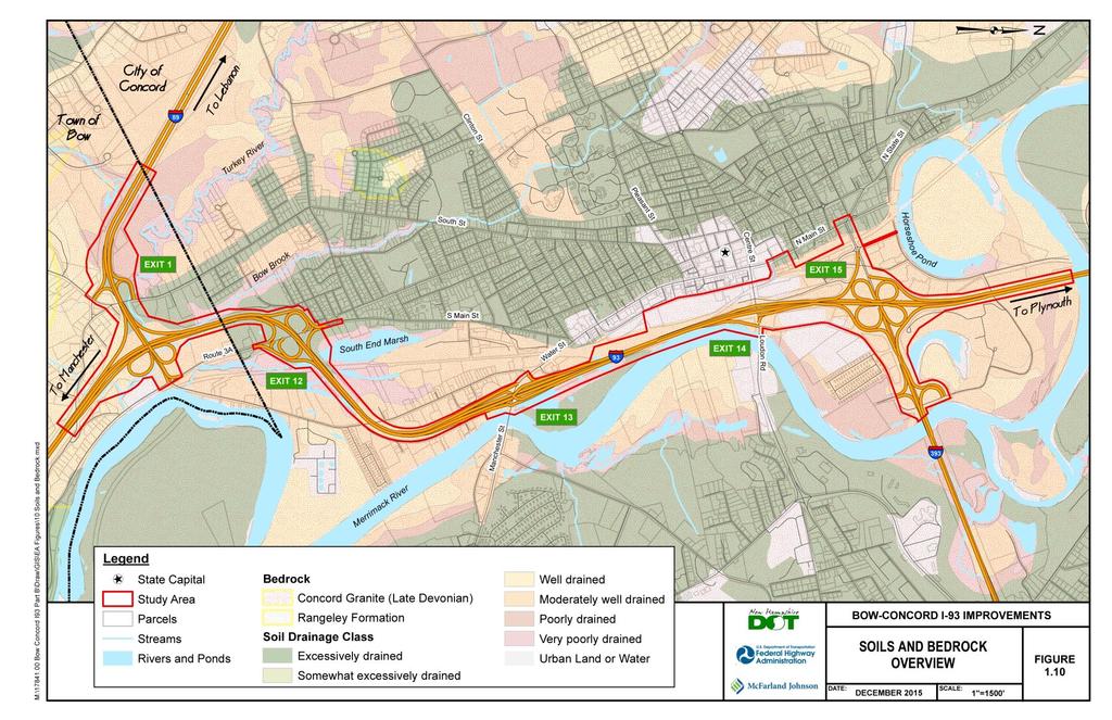
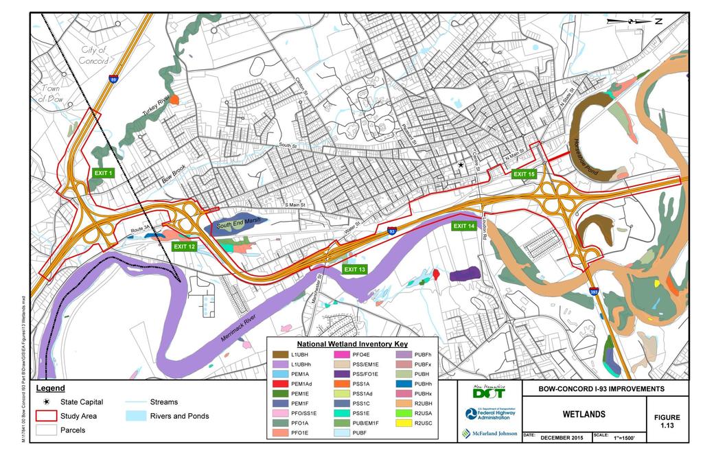
53 Draft Project Purpose and Need Purpose The purpose of the Interstate 93 Bow-Concord project is to address the existing and future transportation needs for all users of this four-mile segment of I-93, while balancing the needs of the surrounding communities, by providing a safe and efficient transportation corridor for people, goods and services.
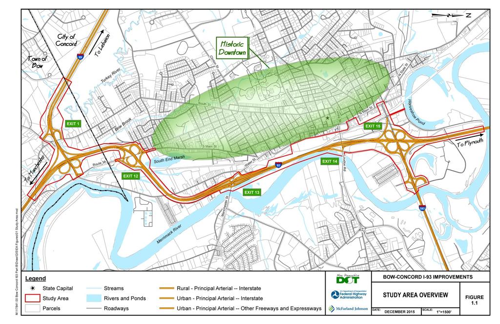
54 Draft Project Purpose and Need Need Mobility Interstate 93 is a principal north-south arterial Interstate highway within the State of New Hampshire and is part of the National System of Interstate and Defense Highways. The segment of Interstate 93 under study intersects two other Interstate highways, Interstate 89 and Interstate 393, providing a vital link for east/west travel, and passes through the City of Concord, the state capital. Interstates 93, 89 and 393 carry a mix of traffic including trucks, cars and buses. The Interstate 93 corridor serves as an important link for New England wide tourist travel to the White Mountains, Lakes Region and Vermont, a regional commuting route for the Concord area, as well as an important local route. As one of the main arterials in the New Hampshire highway system, it is important to maintain the mobility of people, goods and services through this corridor. Capacity Interstate 93 was constructed in the 1960 s and now serves more than 70,000 vehicles per day with peak summer travel at over 85,000 vehicles per day. Traffic volumes on Interstate 93 through Bow and Concord tripled from 1980 to However, since 2004, traffic volumes have remained steady. Growth in the region is expected to occur in the coming years and place a greater burden on the transportation system. With an estimated 80,000 vehicle trips per day by the year 2035, increased congestion and increased travel times are expected, unless there is a reduction in demand, implementation of management strategies or improvements to this important regional travel corridor.
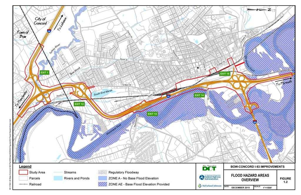
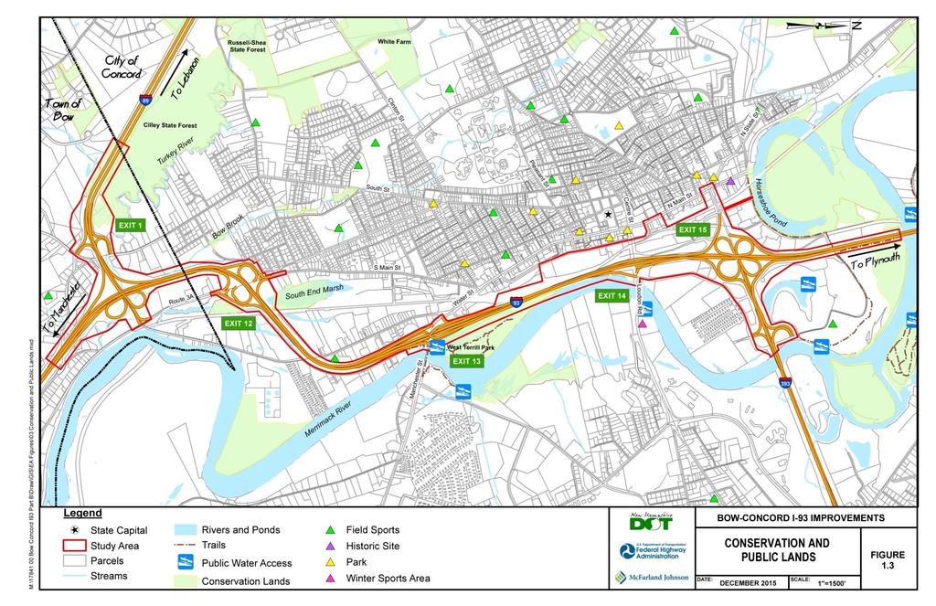
55 Draft Project Purpose and Need Need Regional Plans The project corridor is recognized by the State of New Hampshire and the Central New Hampshire Regional Planning Commission (CNHRPC) as a vital link for statewide travel as well as an important local route within Concord and the Central New Hampshire region. In recognition of these deficiencies, the project has been included in the State s Ten-Year Transportation Improvement Plan for years 2015 to 2024 as an unfunded priority, and is a top long-term transportation priority for the Central New Hampshire Regional Planning Commission (CNHRPC). Safety The approximately four-mile project corridor currently contains numerous geometric deficiencies based upon current highway design standards. The deficiencies include: inadequate distances between entrance and exit ramps (causing weaving), short deceleration distances at exit ramps and short acceleration distances at entrance ramps. A review of the crash data for the period between 2002 and 2012 indicates many of the crashes occur at ramps or between ramps where the deficiencies exist, causing both property damage as well as injuries to drivers. As traffic volumes increase on Interstate 93, these geometric deficiencies will become more of a problem and crashes are anticipated to increase. The corridor also contains three bridges currently on the Red List of state bridges which indicate the critical need for their replacement due to deterioration. Red-listed bridges are defined as those with "known structural deficiencies, poor structural conditions or weight restrictions." Transportation Choice This project corridor accommodates various modes of transportation, but could improve access to those modes or accommodate additional modes. This in turn would make travel more efficient for all users. Commuter rail service is a possibility and bus service continues to expand in the region. Bow and Concord have networks of public trails within and near the project corridor and are actively expanding their networks in an effort to complete the Heritage Trail along the Merrimack River. The project has considered access to and augmentation of these trail systems.

56 Crash History

57 Crash History

58 Crash History

59 Crash History
60

61 Capitol Corridor Study
62 Part B Scope Preliminary Engineering Traffic Modeling Alternatives Development Cost Estimates Rail & Transit Assessment Report Corridor Report Engineering Report Public Participation Public Meetings Project Website Public Hearing NEPA Document Prepare Purpose and Need Environmental Assessment FONSI
63 Resources
64 Resources
65 Resources
66 Resources
67 Resources