Office of Land and Water Evaluations of Groundwater Resources of Southern Mississippi
|
|
|
- Rodger Taylor
- 5 years ago
- Views:
Transcription
1

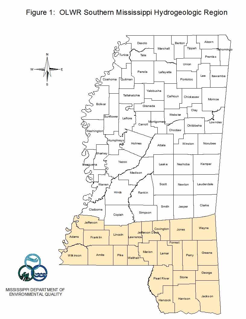
2 Office of Land and Water Evaluations of Groundwater Resources of Southern Mississippi Virtually all of the water used for public and domestic drinking water supplies in southern Mississippi is derived from underground sources. Much of the area is underlain by a thick section of fresh water-bearing sediments, and multiple aquifers are available at most locations. The most widely used aquifers in southern Mississippi are developed in beds of sand that occur within sediments of Oligocene to Pliocene age, above the Bucatunna Formation of the Vicksburg Group. Southwest of a line extending from Warren County eastward through Wayne County these sediments dip in a general Gulf-ward direction at rates ranging from 30 to 100 feet per mile and form a wedge that thickens southward to more than 5,000 feet at the southern tip of Hancock County and southwestern Wilkinson County.
3
4 Geology The interval from late Oligocene through Miocene and Pliocene (approximately 29.0 to 2.59 million years before present) was a period of persistent subsidence and sedimentation in the northern Gulf Coast region. This sequence of sediments has been subdivided in Mississippi, from oldest to youngest, into the Catahoula, Hattiesburg, Pascagoula, and Graham Ferry Formations.
5 System Series Geologic Unit Aquifer Quaternary Holocene Pleistocene Alluvium Prairie-Pamlico Low Terrace Post Graham Ferry Post Graham Ferry Undifferentiated High Terrace Citronelle Pliocene Graham Ferry Upper Graham Ferry Lower Graham Ferry Miocene Pascagoula Hattiesburg Grand Gulf Aquifer System Upper Pascagoula Lower Pascagoula Upper Hattiesburg Lower Hattiesburg Tertiary Catahoula Tatum Limestone Paynes Hammock Fm. Upper Catahoula Lower Catahoula Chickasawhay Ls. Oligocene Bucatunna & Byram Undif. Vicksburg Group Glendon Ls. Marianna & Mint Spring Undif. Forest Hill & Red Bluff Undif. Jackson Group Yazoo Fm. Undif. Eocene Moodys Branch Fm. Claiborne Group Cockfield Fm. Cook Mountain Fm. Figure 3: Stratigraphic Section and Geohydrologic Subdivision of Grand Gulf Aquifer System
6 Geology These sediments are exposed at land surface in much of their area of occurrence in southern Mississippi. Elsewhere they underlie the Citronelle, terrace deposits and loess of Pleistocene age, alluvial deposits along streams in the region, and a thin band of sediments that previous workers have termed coastal deposits that occur in extreme southern Hancock, Harrison, and Jackson Counties. The aquifers within this interval have been called the Miocene Aquifer System. Because these deposits range from late Oligocene to Pliocene age, it is proposed that the name Grand Gulf Aquifer System is more appropriate, as these sediments were at one time considered to constitute the Grand Gulf Group (Hilgard, 1860).
7
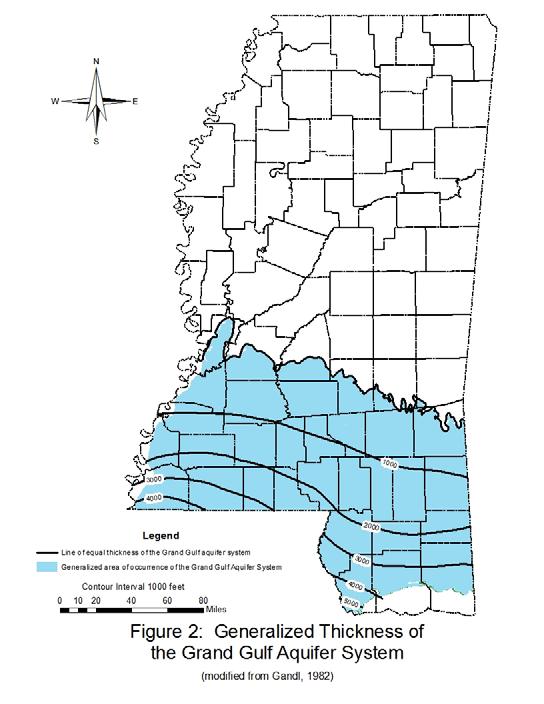
8 Hydrogeology Fresh water, herein defined as containing less than 1,000 mg/l of total dissolved solids (TDS), is available from the Grand Gulf aquifers nearly everywhere within the 17,000 square mile area of their occurrence. Because of its thickness, areal extent, and permeability, the U. S. Geological Survey (USGS) considers this aquifer system to be the largest potential source of groundwater supplies in Mississippi. In many places, only portions of the available fresh-water section are being utilized, and many thick beds of sand containing fresh water have not been tapped. The fresh-water section averages about 1,500 feet in thickness and can be more than 3,000 feet thick in parts of Pearl River and Hancock Counties. The base of the fresh-water section dips southward at a lower rate than the general structural dip of the strata. As a result, the lower part of the Grand Gulf section may contain brackish to saline water in parts of southern Mississippi.
9
10 Office of Land and Water Groundwater Research in Southern Mississippi There have been three long-term projects conducted by the Office of Land and Water Resources (OLWR) in this area that have been critical to our understanding of the groundwater resources of this part of the state and the ability of the Office to discharge its responsibilities regarding water-management 1. Delineation of aquifer intervals in southern Mississippi. 2. Investigation of the occurrence of anomalously high chloride concentrations in some aquifers in the coastal counties. 3. Assessment of available water supplies to support hydraulic fracturing activities in Wilkinson and Amite Counties.
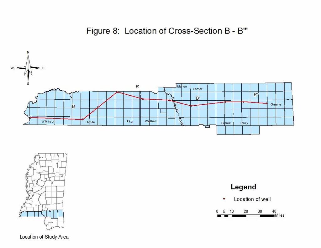
11 Delineation of Aquifer Intervals in Southern Mississippi For many years there had been little to no effort to systematically subdivide the many sand intervals that function as separate aquifers within the Grand Gulf System. As a result, an interval that often consists of 1,000 to 3,000 feet of fresh water-bearing sediments has been collectively referred to as the Miocene Aquifer System. Because of the growing need to make informed decisions concerning water use and systematically characterize water quality, OLWR initiated a study to delineate the individual aquifer units within the Grand Gulf System. As a result of this work, eight aquifer intervals within the Grand Gulf Aquifer System can be identified in the subsurface throughout southern Mississippi. From the base to the top these are the lower and upper Catahoula, lower and upper Hattiesburg, lower and upper Pascagoula, and lower and upper Graham Ferry aquifer intervals.
12
13
14
15
16
17
18
19
20 Results of Aquifer Delineation Effort It is now possible to assign withdrawals of water from wells to specific aquifer intervals, assess the effects of that pumping upon water levels, and make much better water management decisions on that basis. Proposed new large withdrawals of water can be permitted so as to minimize their impacts upon existing users of water. By tracing sand and gravel intervals in the subsurface and projecting them to the surface, aquifer recharge areas can be identified. Trends of water quality characteristics that persist in particular groups of sands can be more readily understood.
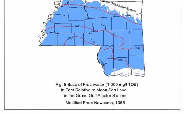
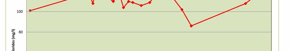
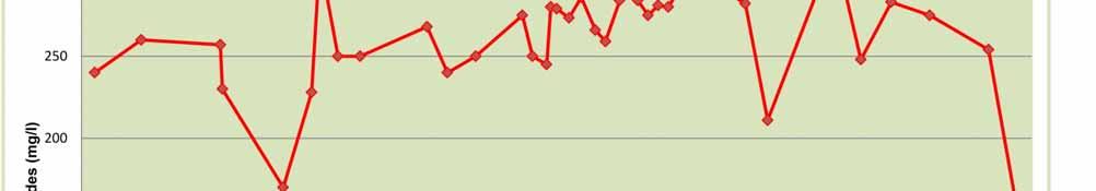
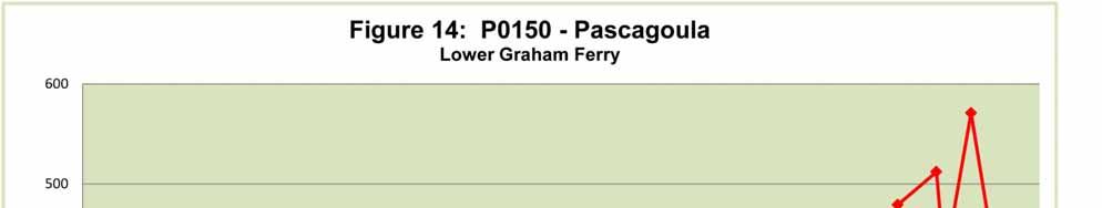
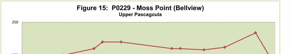
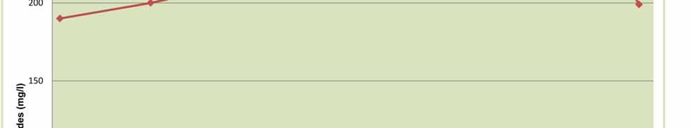
21 Investigation of the High Chloride Concentrations in the Coastal Counties Along most of the Mississippi Gulf Coast, groundwater quality is generally good. However chloride concentrations observed in some wells in the Pascagoula area have been greater than the values that would normally be expected for wells of that depth. The saltwater-fresh water contact occurs at various depths for each of the aquifers in the Grand Gulf System across the coastal counties. The base of fresh water (1,000 mg/l TDS) ranges from approximately 1,400 feet below mean sea level (bmsl) in the Pascagoula area to 3,000 feet bmsl in southwestern Hancock County. At Horn Island, twelve miles south of Pascagoula, the base of fresh water is about 1,500 feet bmsl and is approximately 2,800 feet bmsl south of Ship Island. It is not known how much farther south of the barrier islands the fresh water extends.
22 Investigation of the High Chloride Concentrations in the Coastal Counties During the 1980 s, there was a concern that pumping of water from the Graham Ferry and Pascagoula sands in southern Jackson County was presumably causing saltwater interfaces to move northward toward the pumping centers, degrading water quality in the fresh water aquifers. In 1992, the OLWR began a detailed study to gain a better understanding of the potential for intrusion of saltwater into the aquifers that are sources of drinking water along the coast. OLWR personnel compiled and reviewed all available historic water quality and water level data for the Graham Ferry and Pascagoula aquifers in Jackson County and fieldverified locations of wells from which historic data was available. While work began initially in Jackson County, a network of wells for the purpose of monitoring water levels and water quality in the drinking water aquifers in all three coastal counties was established during the 1990 s and is maintained to the present time. Hundreds of water level measurements have been made and hundreds of water samples have been collected and analyzed in this network since 1992.

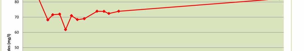
23

24
25


26

27
28
29 Conclusions from Investigation of the High Chloride Concentrations in the Coastal Counties After 24 years of monitoring water levels and water quality in the drinking water aquifers in the coastal counties, there have no systematic increases in chlorides observed, as would be expected if saltwater intrusion was actually occurring. No relationship could be established between variations in chloride concentrations and fluctuations in water levels in wells.
30 Conclusions from Investigation of the High Chloride Concentrations in the Coastal Counties The two most logical reasons for anomalously high concentrations of chlorides in some wells in the Pascagoula area are: 1. Some sands may contain water with high concentrations of chlorides due to incomplete flushing of water that was trapped since the sands were deposited. 2. Damaged and corroded well casings may allow contamination of fresh water-bearing aquifers from shallow aquifers containing brackish water, or from deeper wells screened in sands containing water with naturally-occurring high chloride concentrations and sufficient hydrostatic pressure to flow above land surface and force salty water into other sands.
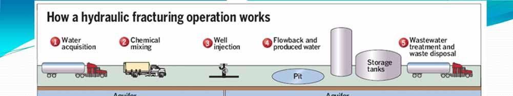
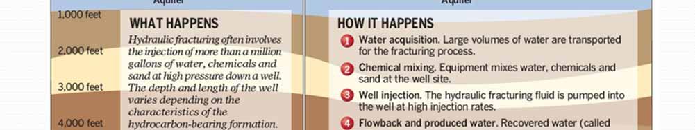
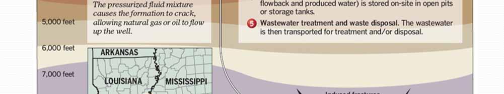
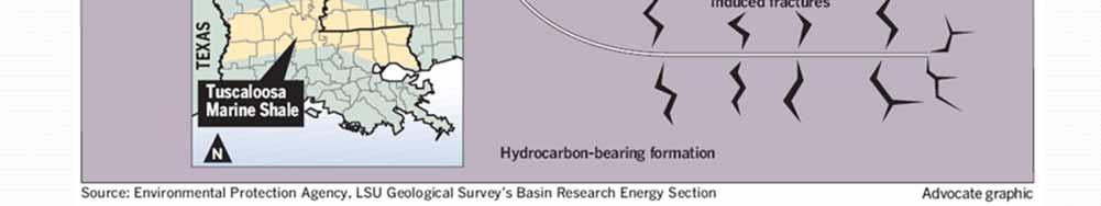
31 Assessment of Available Water Supplies to Support Hydraulic Fracturing in Wilkinson and Amite Counties Several years ago, an extensive mineral leasing effort was launched in southwestern Mississippi associated with potential development of oil production from the Tuscaloosa Marine Shale (TMS). While the TMS has long been known to contain commercial quantities of hydrocarbons, the shale lacks sufficient permeability to support production from conventionally completed wells. In recent years, horizontal drilling has become technically and economically feasible, allowing wells to extend thousands of feet laterally through low permeability, but hydrocarbon-rich rocks such as the TMS. The second technological development that is essential to the development of commercial oil and gas production from these types of rocks is hydraulic fracturing, also known as fracking, a technique that was first applied in 1947 and has been used extensively ever since.

32 Base of Shale Structure
33
34 OLWR Assessment of Water Supplies to Support Hydraulic Fracturing in Wilkinson and Amite Counties Various sources of water were considered that could potentially be utilized to support fracking activities. These include streams and rivers, the Mississippi River (in western Wilkinson County), private ponds, treated municipal wastewater, recycled and treated flowback water from previous fracking activities, and groundwater. Surface water availability is limited in southwestern Mississippi, especially during the summer and fall. In addition, many streams in these counties are scenic and are popular for recreation with very high water clarity. Recognizing the limitations of surface water availability in Wilkinson and Amite Counties, a study was initiated focusing on potential groundwater availability in those counties. Field work was performed by collecting information from public water supply wells and some home wells to establish ambient water quality conditions and water levels before fracking activities began.
35 OLWR Assessment of Water Supplies to Support Hydraulic Fracturing in Wilkinson and Amite Counties Groundwater is the source of all public and domestic drinking water supplies in these counties and most of these wells are relatively shallow. Nineteen public supply wells are less than 600 feet deep, eight are between 600 and 800 feet, and only four are more than 1,000 feet. If alternate water sources are not available, OLWR subsurface studies in Wilkinson and Amite Counties demonstrated that ample good quality groundwater is generally available to depths up to 2,000 feet and reliable groundwater sources could be developed for fracking that would not affect existing users of water.