NC Water Resources Planning April 4, Tom Fransen. North Carolina Division of Water Resources 1
|
|
|
- Abel Skinner
- 5 years ago
- Views:
Transcription


1 NC Water Resources Planning April 4, 2011 Tom Fransen North Carolina Division of Water Resources 1
2 Water links us to our neighbor in a way more profound and complex than any other. -John Thorson 1/18/2011 Slide - 2


3 We expect a lot from our river basins. Aquatic Habitat Riparian Habitat Pollution Dilution Water Supply Power Generation Recreation 3

4 4
5 2010 Ratified Bills Improve River Basin Modeling H1743 Specifies what will be included in a basin model and models will be approved by the EMC. Water Infrastructure Information Needs H1746 Improve the collection and utilization of water and wastewater infrastructure information. Water Supply System Capacity Planning H1747 Revise LWSP when demand exceeds 80% of supply to show how future needs will be met. Amend WQ/IBT Laws H1765 Applicants pay the notification costs and coastal isolated river basins follow the old.22i process until 7/1/
6 Will we have enough water to meet the needs of a growing population? 14,000 4,000 Population / 1,000 12,000 10,000 8,000 6,000 4,000 2,000 3,500 3,000 2,500 2,000 1,500 1, MGD NC water use excluding power generation 6


7 Drought Critical Period Summer of 2002 Under global warming drought could overtake much of the world by UCAR 10/19/2010 7

8 Current Drought Conditions 2/1/2011 Drought Monitor 2/3/ Day Average Streamflow
9 What North Carolina Is Doing To Provide Water Supplies For Future Needs. Focus 3 Major Areas Data for Water Management Water Supply Planning Regulation 9

10 Surface Water Gaging Ground Water Monitoring Gage downstream of Jordan Dam in operation 10


11 Water Systems Slide - 11


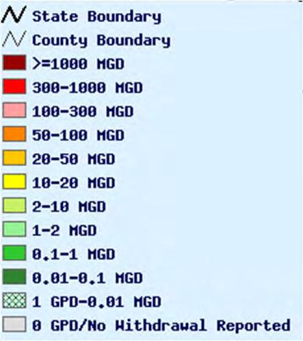
12 Cape Fear Water Withdrawals 12

13 Cape Fear Water Withdrawals Includes Thermal Electric Power Without Thermal Electric Power 13
14 What North Carolina Needs to Do to Provide Water Supplies for Future Needs. Focus 3 Major Areas Data for Water Management Water Supply Planning Regulation 14
15 Value of Regional Water Supply Planning Total savings per mgd Annual Net benefit per household B/C Ratio Atlanta $1.48 $ Boston $3.45 $ Seattle $1.06 $ Phoenix $1.76 $ Houston $10.33 $ Median $1.76 $
16 Water Resources Planning & Basin Modeling Water Resources Planning (No EMC Approval) River Basin Modeling (EMC Approval) 1/18/2011 Slide - 16


17 Modeling and Planning Can Help Prevent This If Instream Flows and Uses are Included in the Equation 17

18 Slide - 18

19 Modeling Basics Hydrologic Cycle Questions Is there enough water to sustain expected uses now and in the future? DWR does consider ecologic flows to be part of expected uses. Where, when and for how long could we expect to experience shortages? 19
20 River Basin Model Basics Water Balance Model Inflow Outflow = Change in Storage Model is like a checkbook Inflow = Salary Outflow = Expenses Storage = Bank Account The complexity is developing the data and equations to describe the 3 variables. Slide - 20
21 What is a River Basin Hydrologic Model? Hydrologic Model Water Resources Plan Inflows Operation Guidelines Current and Planned Water Use Historical and Projected Evaluation Criteria Is there enough water to sustain expected current and future uses? "Unimpaired" Historical Streamflows Reservoir Operations Permitted Minimum Flows Drought Plans Local Water Supply Plans Self-Supplied Industries Agricultural Other Registered Withdrawers Water Supply Ecological Flows Recreation Power Production Alternative Streamflows Climate Change Landuse Changes Altered Baseflows Changes in demand resulting from climate change.
22 Hydrologic Stationarity Key Assumption The future will be statistically indistinguishable from the past. Is stationarity dead? Climate change and coping with nonstationarity in water and ecosystem management.


23 Hydrologic River Basin Modeling Software OASIS A modeling program for simulating water supply systems. OASIS Flexibility In Simulating Reservoir Operations Is One Of The Reasons We Selected It As Our Preferred Model. 23
24 Basin Modeling Limits Basin Model is not a water quality model. OASIS can be linked to a water quality model. The outputs can be used to define boundary conditions to a water quality model. The OASIS general is not the model for flood studies. OASIS does use channel geometry which is needed to flood stages associated with flooding events. OASIS has been successfully on the Lower Roanoke for flood plain flooding. The OASIS does not simulate ground water. OASIS can be linked to a ground water model. The outputs can be used to define boundary conditions to a ground water model. Slide - 24


25 Nodes And Arcs Nodes are locations of interest Reservoirs Demands Junctions Arcs represent flow between nodes Stream reaches Canals pipelines Groundwater seepage Etc. Slide - 25

26 Water Demands Annual Average Use Ann Ave Use / Seasonal Patterns Seasonal Use Patterns Raleigh's Modeled Demands MGD monthly 2030monthly 2050monthly 2008average 2030average 2050average Jan Feb Mar Apr May Jun Jul Aug Sep Oct Nov Dec Slide - 26


27 Impacts to reservoir water levels
28 Data + Modeling = Management One of the most sophisticated programs in SE. Accomplished with a minimal amount of resources.


29 NC GA Model Comparison
30 What North Carolina Needs to Do to Provide Water Supplies for Future Needs. Focus 3 Major Areas Data for Water Management Water Supply Planning Regulation 30
31 What if there is not enough water? Projected growth greatly exceeds available supply. Opportunity for local solutions: New sources, interconnections, IBTs, etc One regulatory option currently available: EMC designates area a Capacity Use Area One area in State already designated as CUA: 15 Counties in Central Coastal Plain CUA.
32 NC Riparian Rights Riparian property owners have right to reasonable use of water. Can not adversely affect quantity or quality. Maintain instream flow at reasonable level. Impairment often a water quality issue. 32
33 The Water Use Act of 1967 G.S to.22 Phosphate mining in Beaufort County led to creation of the Water Use Act Reasonable regulation to conserve and maintain water resources so they can be used to the fullest extent possible Central Coastal Plain Capacity Use Area The only CUA in the State. 33

34 Black Creek Aquifer in CUA Ground Water Levels Improvement
35 What is an Interbasin Transfer? An interbasin transfer is the movement of surface water from one river basin into another. The purpose of the Interbasin Transfer Law is to take a pause to be sure it is good public policy before moving water from one river basin into another. The Interbasin Transfer Law does NOT prohibit transfers. 35


36


37 Jordan Lake Overview 37
38 Jordan Lake WS Allocation Round 4 Allocation Process Three Simultaneous Tracks JORDAN APPLICATIONS WATER SUPPLY PLAN HYDROLOGIC MODEL 38
39 Addition Information Division s Website - Today s Presentation - Data Planning & Modeling Regulation Drought
40 Questions Contact Information Tom Fransen