Chapter 105 Program Development Updates Society of Women Environmental Professionals 2018 Annual Regulatory Update Seminar November 1, 2018
|
|
|
- Grace Price
- 5 years ago
- Views:
Transcription
1 Chapter 105 Program Development Updates Society of Women Environmental Professionals 2018 Annual Regulatory Update Seminar November 1, 2018 David Goerman, Jr. Bureau of Waterways Engineering and Wetlands Pennsylvania Department of Environmental Protection

2 Overview of Efforts Finalize Function Based Compensation Protocol L2RAP Revision Headwaters In Lieu Fee Draft Instrument Restoration Environmental Assessment
3 Overview of Efforts Current Program Development Efforts PA Wetland Probability of Occurrence and Restorable Lands Mapping Vegetation Communities Predictor Tool HARRS - Legacy Watershed Alteration Characterization/Profile Development Watercourse Identification Tools
4 Function Based Compensation Protocol Revised Riverine Function Group Structure RS or HYD1 BGC1 HAB1

5 Function Based Compensation Protocol Determining RS vs HYD1 Function Group Watershed size, gradient and valley type

6 Function Based Compensation Protocol Confined - confinement ratio less than 4.0 and Unconfined Valleys - confinement ratio 4.0

7 Function Based Compensation Protocol Finalizing Draft Guidance Final Legal review Publication in first quarter 2019 Effective date TBD likely 3-4 th quarter 2019 Completion of ILF Approval process Training and overview in 2019
8 L2RAPS Revision - Headwaters Utilization of existing Wetland and Riverine Guidance Better address linear headwater systems that exhibit both resource features Utilize a combination of existing condition indices Landcover Stressors/Alteration Channel Conditions Roadbed Presence
9 Restoration Environmental Assessment EA Form specifically for Restoration Activities Demonstration of Degradation Evaluate resource degradation at a system level - considers multiple measures and indicators, including legacy alterations and current resource responses. Resource Degradation Demonstration Establishes the Basis for the Alternatives Analysis
10 Restoration Environmental Assessment Demonstration of Degradation Identifying cause of degradation critical to process Evaluate both historic (legacy) and modern alterations causing degradation Emphasis on landscape and resource appropriate restorative practices that support long-term dynamically stable resources
11 HARRS - Legacy Alteration Profiles Utilizing EPA Wetland Program Development Grant project to Identify and characterize the effect of watershed legacy alterations on the Hydrologic, Geomorphic and Biogeochemical beyond legacy sediment Use as a basis for future Categorical Environmental Assessments

12 HARRS - Legacy Alteration Profiles Create Legacy Alteration Profiles Profiles Identify and characterize historic alterations and the effects Industrial Timbering Era Water Power Era Agriculture Mineral Extraction

13 HARRS - Hydrologic Legacies Agriculture tile and ditch practices Road cuts intercept hillslope processes


14 HARRS - Geomorphic Legacies Stream Relocation

15 PA Wetland Occurrence Probability Mapping Mapping using a two-step modeling process combining raster and vector based approaches Identify existing/unmapped wetlands and restorable lands Complete high resolution landcover for western PA Chesapeake Bay Drainage Completed Remainder of PA

16 PA Wetland Occurrence Probability Mapping Numerous uses for updated wetland mapping Determine Level 1 resource conditions Assist in Level 2 preparation ILF and Banking Compensation Planning Framework Basic Planning Updatable layer / geodatabase for related wetland data Hunter et. Al., 2012
17 Vegetation Community Predictor Tool Online predictive plant community planting tool - Pennsylvania Restoration Planting Community Prediction Tool (2019) Guide management, restoration, and compensation activities at specific sites in Pennsylvania (and portions of Maryland). Linked to supporting resources such as the Pennsylvania Plant Community Classification ( es.aspx)
18 Vegetation Community Predictor Tool Past EPA Wetland Program Development Grant projects done to identify and classify wetland and riparian vegetation communities (Zimmerman 2008, 2012) Prediction based on similarity of abiotic data from existing PNHP vegetation community Intend to develop a web based geospatial tool to identify likely terrestrial, palustrine and riparian vegetation communities based on delineation data and calculate Rapid FQI scores ( )
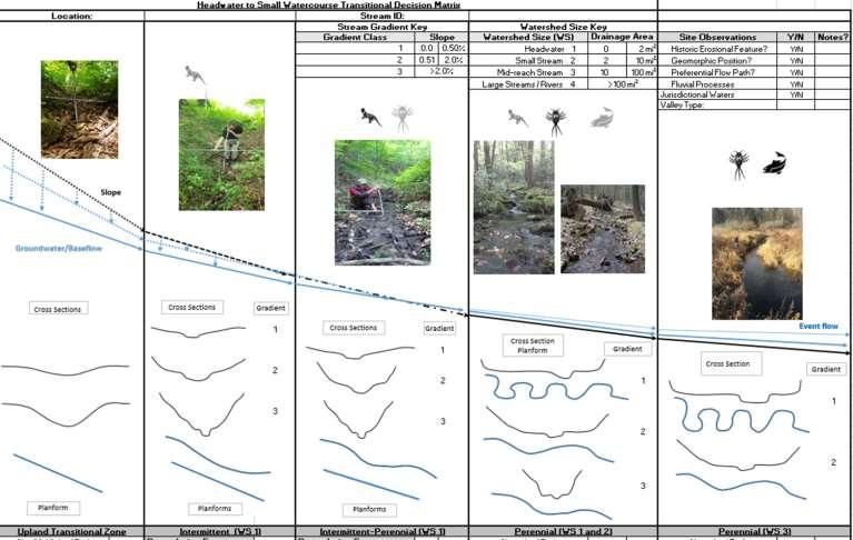
19 Watercourse Identification
20 References o o Hunter, E.A., Raney, P.A., Gibbs, J.P., and Leopold, D.J Improving wetland mitigation through community distribution modeling and a patch based ranking scheme. Wetlands. 32: Walsh, M.C., J. Deeds, and B. Nightingale User s Manual and Data Guide to the Pennsylvania Aquatic Community Classification. Pennsylvania Natural Heritage Program, Western Pennsylvania Conservancy, Middletown, PA, and Pittsburgh, PA. o Zimmerman, E.A. T. Davis, M. Furedi, B. Eichelberger, J.I. McPherson, S.D. Seymour, G. Podniesinski, N.M. Dewar, and J. Wagner (editors) Terrestrial and Palustrine Plant Communities of Pennsylvania 2 nd Edition (Wetlands). Pennsylvania Natural Heritage Program, Pennsylvania Department of Conservation and Natural Resources, Harrisburg, Pennsylvania. o Zimmerman, E., and G. Podniesinski Classification, Assessment and Protection of Floodplain Wetlands of the Ohio Drainage. U.S. EPA Wetland Protection State Development Grant no. CD Pennsylvania Natural Heritage Program, Western Pennsylvania Conservancy, Pittsburgh, PA.

21 Questions? David Goerman, Jr. PA Dept. Environmental Protection Bureau of Waterways Engineering and Wetlands