6.0 ALTERNATIVES. The alternatives that are evaluated in this section include the following:
|
|
|
- Elaine Skinner
- 5 years ago
- Views:
Transcription
1 6.1 INTRODUCTION 6.0 ALTERNATIVES This chapter evaluates alternatives to the proposed project and examines the potential environmental impacts associated with each alternative. Through comparison of these alternatives to the project, the relative environmental advantages and disadvantages of each are weighed and analyzed. The CEQA Guidelines require that the range of alternatives addressed in an EIR should be governed by a rule of reason. Not every conceivable alternative must be addressed, nor do infeasible alternatives need to be considered (CEQA Guidelines Section [a]). When addressing feasibility, Section of the CEQA Guidelines states that the factors that may be taken into account when addressing the feasibility of alternatives are site suitability, economic viability, availability of infrastructure, other plans or regulatory limitations, and jurisdictional boundaries, and whether the proponent can reasonably acquire, control or otherwise have access to the alternative site. The Guidelines state that the discussion of alternatives must focus on alternatives capable of either avoiding or substantially lessening any significant environmental effects of the project, even if the alternative would impede, to some degree, the attainment of the project objectives, which are identified in Section 3.4 (Project Description, Objectives) of this EIR, or would be more costly. The Guidelines provide that an EIR need not consider alternatives whose implementation is remote or speculative, and finally that the analysis of effects of alternatives need not be presented in the same level of detail as the assessment of the project impacts. Based on the CEQA Guidelines, several factors need to be considered in determining the range of alternatives to be analyzed in an EIR and the level of analytical detail that should be provided for each alternative. These factors include (1) the nature of the significant impacts of the proposed project, (2) the ability of alternatives to avoid or lessen the significant impacts associated with the project, (3) the ability of the alternatives to meet the objectives of the project, and (4) the feasibility of the alternatives. The analysis in this EIR indicates that the following significant and unavoidable impacts would occur from implementation of the proposed project: Traffic (roadway impacts on Storke Avenue north of Hollister Avenue); Noise (short-term construction period impacts); and Air Quality (operational emission of criteria pollutants). Thus, the alternatives to the proposed project are examined to determine their potential to minimize or avoid the significant and unavoidable impacts that would result from implementation of the proposed project. 6.2 ALTERNATIVES TO THE PROPOSED PROJECT The alternatives that are evaluated in this section include the following: Alternative 1: South Parcel/Storke Whittier Development (formerly known as Project B) To avoid potential wetlands impacts on the North Parcel, this alternative (the South Parcel alternatives) assumes that 207 units of faculty housing would be constructed on the (North Campus) South Parcel, the North Parcel would remain undeveloped, and 151 units of Family 6-1
2 OPEN SPACE PLAN, AND LRDP AMENDMENT EIR Student Housing would be developed on the Storke-Whittier Parcel (same as the proposed project). Methodology for Selection of Alternative 1. When the Notice of Preparation for the proposed project was filed on July 25, 2003, the University identified a Project A (the proposed project) and a second Project B, involving the relocation of faculty housing from the North Parcel to the South Parcel and a reduction of the number of units of Family Student Housing. To simplify the analysis of the proposed project, the former Project B has become Alternative 3 (the South Parcel/Storke Whittier Development Scenario ). Because this alternative scenario remains a viable option to meet project objectives while reducing potentially significant impacts, this alternative will be evaluated at an equal level of detail as the proposed project so that it can be selected by the decision-maker if the decision-maker determines that is preferable to the Project and other alternatives analyzed herein for environmental or other reasons. Alternative 2: No Project: No Development Under this alternative, the proposed project would not be implemented. No residential buildings would be constructed, no open space improvements would occur, and no habitat improvements would occur. Methodology for Selection of Alternative 2. Section (e)(1) of the CEQA Guidelines state that the specific alternative of no project shall also be evaluated along with its impact. The purpose of describing and analyzing a no project alternative is to allow decision-makers to compare the impacts of approving the proposed project with the impacts of not approving the proposed project. Alternative 3: North and South Parcel Development (Existing LRDP) This alternative assumes that the existing 1990 Long Range Development Plan, as amended in 1998, would remain in effect. Under this alternative, 147 units of faculty housing would be developed on the North Parcel, 122 units of faculty housing would be developed on the South Parcel, and 144 units of student housing would be developed on the Storke-Whittier site. No other open space improvements would occur, except as provided for in the 1990 LRDP (as amended). This alternative provides for a plan-to-plan comparison of the 1990 LRDP (as amended) and the proposed LRDP amendment, as articulated in Section (e)(3)(A) of the CEQA Guidelines. Methodology for Selection of Alternative 3. Section (e)(3)(A) of the CEQA Guidelines states that when the project is the revision of an existing land use or regulatory plan, policy, or ongoing operation, the no project alternative will be the continuation of the existing plan, policy, or operation into the future. Therefore, under Alternative 3, the impacts of the proposed LRDP amendment (e.g., to change land use designations on the North and West Campuses) are compared to the impacts that would occur under the existing plan (e.g., the 1990 LRDP, as amended in 1998). Alternative 4: Maximum Housing Development Under this alternative, the number of housing units would be maximized to assist the University in meeting long-term housing needs: 236 units of faculty housing would be developed on the North Parcel, 207 units of faculty 6-2
3 housing would be developed on the South Parcel, and 151 units of Family Student Housing would be developed on the Storke-Whittier site. Methodology for Selection of Alternative 4. In 1994 the University purchased the North Campus with the intent of providing faculty and student housing. This alternative is in response to the identified project objective to maximize the ability of the North Campus to meet identified University housing needs. Alternative 5: Off-Site Alternative Under this alternative, the faculty and family student housing would be developed somewhere else. Methodology for Selection of Alternative 5. To reduce potential impact of the proposed project, this alternative considers whether development of the proposed project at an alternative site would reduce impacts. 6.3 ALTERNATIVES NOT CONSIDERED IN THIS EIR During the scoping process, other alternatives were also considered, but were found to be infeasible, as described in the following sections Residential Development on the UCSB Main or Storke Campus The 1990 Long Range Development Plan identified a range of building sites on the USCB Main, Storke, and West Campuses, and proposed a range of land uses for those building sites. The sites were identified in the LRDP on Figure 12 (Main Campus Plan, refer to Figure 4.1-1), Figure 23 (Storke Campus Plan, refer to Figure 4.1-3) and Figure 24 (West Campus Plan, refer to Figure 4.1-4), and also listed in Table 13. In conjunction with the subsequent amendments of the LRDP, Table 13 has been updated as relevant. Per the land use provisions of the LRDP, certain areas of the University have been designated for academic programs, while others, generally at the periphery of the Main Campus, and sites on the Storke and West Campuses, have been identified for support functions, such as housing. No remaining sites on the Main Campus are identified for housing, although housing support functions are identified for sites 33 and 38 (which will be occupied by the Residential Life Resources Center). Of the remaining sites identified for academic functions, these sites range from 4,300 gross square feet to 318,000 gsf (7.3 acres). On the Storke Campus, the only suitable site for housing is already proposed for such purpose as the site for the San Clemente student housing project, and thus is unavailable. As the faculty housing project would occupy approximately 23 acres and the family student housing project would occupy approximately 13 acres, there are no sites identified in the LRDP on the Main Campus or Storke Campus that could accommodate either residential project. Therefore, an alternative that would build faculty and/or family student housing on the UCSB Main or Storke Campuses is considered infeasible and is not analyzed in this EIR. 6-3
4 OPEN SPACE PLAN, AND LRDP AMENDMENT EIR Increased Building Heights The proposed project would limit the height of residential structures on the North Parcel and the Storke-Whittier Parcel to 35 feet. If the height of those structures was increased, the amount of land area occupied by residential structures (or footprint) could be reduced. For example, if the height of structures were doubled to 70 feet, then the footprint of those structures would be significantly reduced. However, the overall footprint of residential development would not necessarily be reduced in half, as the need for roads and parking areas would remain the same. Building heights greater than 35 feet would be inconsistent with the height limits imposed by the 1990 LRDP for the West Campus, which were extended to the North Campus in conjunction with the 1998 LRDP amendment (which permitted student residences to reach 45 reach). Increased building heights would also result in buildings that are out-of-scale with adjacent structures (including single family homes north of the North Parcel and two-story residences at the West Campus Family Student Housing), and would, therefore, be inconsistent with LRDP Policy , which specifies that new structures on the campus shall be in general conformance with the scale and character of surrounding development. Further, taller buildings would have the potential to increase impacts associated with loss of scenic vistas. Therefore, an alternative that would increase building heights is considered infeasible and is not analyzed in this EIR Reduced Density To reduce direct impacts to Biological Resources, the footprint of residential development could be decreased, by reducing the density of residential development. The proposed faculty housing on the North Parcel would result in direct loss of 2.45 acres of wetlands and riparian areas. To eliminate direct loss of wetlands and retain a 100-foot buffer around them, an analysis of the development potential of the North Parcel was undertaken. This analysis concluded that only an estimated 16 units of faculty housing could be developed within those constraints. One of the primary reasons is that the location of existing wetlands limits access to those portions of the site where no wetlands are located. The development of only 16 units of faculty housing would be inconsistent with the project objectives to provide additional on-campus faculty housing to meet long-term demand and assist the University in the recruitment and retention of faculty, and to effectively utilize the North Campus property as a viable resource to meet identified University housing needs. Therefore, an alternative that reduces the footprint of development on the North Parcel to eliminate direct impacts to wetlands is considered infeasible and is not analyzed in this EIR. Further, the alternative of avoiding development on the North Campus (which is substantially equivalent to developing only 16 units on the North Campus) for the purpose of mitigating impacts on wetlands is already analyzed in the No Project Alternative (Alternative 2) and the South Parcel/Stoke-Whittier Parcel Development (Alternative 1). Alternative 3 (North and South Parcel Development Existing LRDP) proposes the development of 147 units of faculty housing on the North Parcel, per the land use designation in the existing LRDP (as amended in 1998), and thus also serves as a reduced density alternative for North Parcel for the purposes of this EIR. 6-4
5 Finally, it should be noted that as originally proposed, the Sierra Madre Family Student Housing project would have included development on the northern Storke-Whittier Parcel, west of the parking lot for the Ocean Meadows Golf Course, which would have resulted in the direct loss of approximately 0.51 acres of wetlands at that location. During design development, the layout of the proposed Family Student Housing project was revised to eliminate all development on the parcel west of the golf course parking lot, thereby eliminating the loss of wetlands at the northern Storke-Whittier Parcel. 6.4 ANALYSIS OF ALTERNATIVES TO THE PROPOSED PROJECT This section provides an analysis of the environmental impacts of each of the project alternatives discussed in Section 6.2, including a comparison of the potential impacts of the alternative to the proposed project. Five alternatives are analyzed in this section, including the No Project alternative. The South Parcel/Storke-Whittier Development Alternative (No. 1) analyzes avoiding North Parcel development entirely to reduce impacts to wetlands on the North Parcel. The No Project Alternative (No. 2) results in no new development and is analyzed to identify the circumstances that would result if the project does not proceed. The North Parcel/South Parcel Alternative (No. 3) provides for the continued implementation of the existing 1990 LRDP (as amended) with a reduced amount of development on the North Parcel, and is analyzed to allow The Regents to compare the impacts of approving the proposed amendment of the LRDP with the impacts of proceeding with development under the existing LRDP. Alternative 4 considers an alternative to maximize the housing potential of the North Campus, and Alternative 5 analyzes an off-site alternative for residential development. To provide a consistent basis for comparison, it is assumed that for each of the alternatives, Mitigation Measures identified for the proposed project would be implemented as applicable for each of the Alternative 1: South Parcel/Storke-Whittier Development Description To avoid potential impacts to wetlands on the North Parcel, this alternative assumes that the North Parcel would be retained as undeveloped property, and that 207 units of faculty housing would be development on the South Parcel (of the North Campus), and 151 units of family student housing would be developed on the Storke-Whittier Parcel. This alternative would not implement the concepts articulated in Joint Proposal (including the resultant Open Space Plan), as the South Parcel would be utilized for development rather than open space and recreational purposes. Habitat restoration or coastal access improvements would be limited to those provided for in the COPR Management Plan. 6-5
6 OPEN SPACE PLAN, AND LRDP AMENDMENT EIR LRDP Amendment Under this alternative, the existing LRDP, which currently permits 122 units of faculty housing on the South Parcel, would be amended to permit the development of 207 units of faculty housing and to designate the North Parcel as open space. Other proposed modifications to the LRDP would be similar to the proposed project, as summarized in Table 6-1. Table 6-1. Alternative 1 LRDP Amendments Campus Area Current LRDP Designation Proposed LRDP Designation North Campus North Parcel Up to 147 units of faculty housing 26 acres of Open Space South Parcel Up to 122 units of faculty housing 207 units of faculty housing and 28.7 acres of Open Space Storke-Whittier Parcel Up to 144 units of family student Up to 151 units of family student housing housing Ellwood Marine Terminal West Campus West Campus Mesa Future Development Area West Campus Mesa Garden Area and Northern Slough Finger 17.5 acres of oil storage facility to be converted to Open Space in 2016 following lease expiration No change from current LRDP designation 100 units of faculty housing 50 units of faculty housing 25.3 acres of recreation and other use No change Coal Oil Point Replace Cliff House No change from current LRDP designation COPR acres of existing Reserve, plus 40.0 acre expansion site, designated as Environmentally Sensitive Habitat Areas and Natural Reserve Designate acres as Natural Reserve West Campus Bluffs 37.2 acres of Open Space, pending 37.2 acres of Open Space approval of faculty housing elsewhere Faculty Housing 100 units 50 units Orafalea Children s Center 10,000 gsf expansion No change Total Change in Housing Total Change in Open Space and Natural Area 513 units of Faculty and Family Student Housing acres of Open Space and Natural Reserve 408 units of Faculty and Family Student Housing 283 acres of Open Space and Natural Reserve 6-6
7 Specific Projects Under this alternative, two sites would be developed: (1) the North Campus Faculty Housing (on the South Parcel, instead of the North Parcel) and (2) the Sierra Madre Family Student Housing on the Storke-Whittier Parcel South Parcel Faculty Housing This alternative would provide 207 units of housing on the South Parcel of the North Campus (south and west of the Ocean Meadows Golf Course), in a mix of detached single family, duplex and courtyard housing. (Refer to Figure 6-1.). Units would be two, three, or four bedrooms and there would be a mix of two and three story units. Although the homes would vary in size, the total amount of development would be approximately 1,300 gross square feet per unit. The complex would also include a community recreation facility in a common building with a swimming pool. None of the structures would exceed 35 feet in height. The amount of built space would total approximately 342,250 gross square feet, including garages and the community center and pool. Vehicular access to the site would be provided via Storke Road (near the intersection with El Colegio, along the route of the existing Venoco Access Road, with a bridge (and culvert) over Devereux Creek. Internal roads and alleyways would be narrow in width to serve as traffic calming measures. A total of approximately 485 spaces of off-street parking would be provided, with 300 spaces for the duplex housing, 92 spaces for the townhome housing, and 18 spaces for the detached family housing. In addition, approximately 75 spaces of on-street parking would be available for visitors. The twin 24-inch drainage pipes and concrete barrier over Devereux Creek that separates the creek from the Devereux Slough (at the southern edge of the Ocean Meadows Golf Course) would be replaced with a 42 x 60-inch box culvert/bridge to increase the discharge capacity of the creek. Development would occur on approximately 40 of the 68.7 acres on the South Parcel (as the site layout would be spread out to avoid existing wetland areas). Existing informal trails around the perimeter of the site would be maintained, linking to the Window Trail along the western boundary of the North Campus. To minimize runoff from impervious surfaces, pervious areas, vegetated filter strips, porous pavements would be utilized where appropriate. Surface runoff would be conveyed via surface channels and cobbled swales into bioswales landscaped with native wetland plant species. Sustainable design practices would be implemented using green resource and energy conservation methods. 100-foot buffers would be provided around all wetlands and drainage channels and no construction would occur within those buffers. 6-7
8 Table 6-2. Summary of Project and Site Characteristics: South Parcel Faculty Housing Proposed Land Use Residential: courtyard, duplex, and single-family housing Residential Dwelling Units Detached Single Family 105 Proposed Attached Single Family 22 Courtyard Townhouse 48 Duplex Housing 8 Courtyard Apartment 24 Total: 207 Building Height 35 feet Total Development 342,250 gross square feet Proposed Parking Spaces 2 per unit 414 On-Street 75 Total: 489 Undeveloped Open Space 28.7 acres Project Access Vehicular: Storke Road and a reconstructed Venoco Access Road Pedestrian: Trails from to the Windrow Trail on the west and east from Storke Road Sierra Madre Family Student Housing Similar to the proposed project, the Sierra Madre Family Student Housing component of this alternative would provide 151 units situated on approximately 10.7 acres of the 14.8-acre parcel, along with parking provided on the 2.8-acre lawn area located east of the existing West Campus Family Student Housing. Housing would be located along Storke Road, from north of the El Colegio and Storke Road intersection towards Whittier Drive, then westward along Whittier Drive. No development would occur on the parcel located west of the existing Ocean Meadows Golf Course parking lot. The housing would be provided in seven clustered complexes along Storke Road (refer to Figure 3.4, in Chapter 3, Project Description), set back a minimum of 75 feet from Storke Road and 50 feet from the golf course. The buildings would generally consist of two- and three-story buildings with single level flats with a maximum building height of 35 feet, arranged around courtyard green spaces. Units would be three bedrooms with two baths and average 1,380 gross square feet. Project amenities would include an approximately 7,375-square-foot community building with meeting, laundry and recreation facilities, an approximately 725-square-foot storage building, and play structures for toddlers and school-age children. With the support space, the amount of developed space would total approximately 182,000 gross square feet. A site plan for the proposed Sierra Madre Family Student Housing is presented on Figure 3-4 (Project Description) and a conceptual rendering is provided in Figure 3-5 (also in the Project Description). 6-8

9
10 Approximately 10.7 of the 14.8 acres on the main Storke-Whittier Parcel would be occupied by structures, roads and parking lots, with an additional 2.8 acres of existing lawn area (adjacent the West Campus Family Student Housing complex) converted to surface parking. Thus, physical improvements would occupy a total area of approximately 13.5 acres. Grading activities would include approximately 9,400 cubic yard of fill and approximately 5,900 cubic yards of cut, with a net import of approximately 3,500 cubic yards. All building pads would be elevated at least 1 foot above the 100-year flood hazard zone, to reduce potential flood hazards to building occupants. To minimize runoff from impervious surfaces, pervious areas, vegetated filter strips, and porous pavements would be utilized where appropriate. Surface runoff would be conveyed via surface channels and cobbled swales into bioswales landscaped with native wetland plant species prior to prior to discharge into the eastern tributary of Devereux Creek. As required by law, a Storm Water Pollution Prevention Plan (SWPPP) will be implemented on the site, reducing run-off impacts. Development would include a total of 552 parking spaces, 219 of which would replace existing parking for the adjacent West Campus Apartments that would be removed during construction, for a net increase of 333 spaces (2.2 spaces per unit) to serve the new housing. Much of the frontage along Storke Road would be occupied by a landscaped parking lot. A landscape buffer and Class I bike path or multi-use trail would separate this parking area from Storke Road. Table 6-3. Summary of Project and Site Characteristics: Sierra Madre Family Student Housing Proposed Land Use Proposed Dwelling Units Building Height Total Development Residential: single level flats 151 units 35 feet 229,740 gross square feet Proposed Parking Spaces Replacement Parking: 219 Undeveloped Open Space Project Access Sierra Madre Parking (Net New) Spaces: 333 Total: 552 spaces 3.1 acres Vehicular: Whittier Drive (1 access points) and Storke Road (3 access points) Pedestrian: Whittier Drive, Storke Road Access to the northern cluster of residential units would be provided via a driveway off of Whittier Drive and a driveway on Storke Road. Vehicular Access to the southern residential clusters would be provided via a driveway off Storke Road, and a new access road, located 6-11
11 OPEN SPACE PLAN, AND LRDP AMENDMENT EIR generally at the same location at the existing Venoco Access Road (to the Ellwood Marine Terminal [EMT]). The reconfigured road would also provide access to the existing West Campus Family Student Housing complex and an adjacent private residential development on the southeastern side of the Ocean Meadows Golf Course (discussed more fully in the separate EIR prepared by the County of Santa Barbara for the Ocean Meadows Residences) COPR Management Plan The Draft COPR Management Plan would continue to be implemented, including that 40-acre portion of the reserve designated as an expansion area in Management actions would continue to protect snowy plover habitat, remove nonnative vegetation, restore degraded habitat areas, and replace existing informal trails with boardwalks and/or coastal access stairways, at the western edge of the original reserve, and west of Coal Oil Point, to reduce coastal erosion and increase protection of the snowy plover habitat area Construction Phasing As this project would involve the same amount of residential construction, the schedule for implementation of this alternative would be the same as the proposed project, with an approximately 30-month construction period Comparison of Environmental Effects A comparison of the potential environmental effects of this alternative to the proposed project follows. This analysis assumes that relevant LRDP Policies would be implemented, which are identified for each environmental topic in Chapter 3 (and thus are not repeated herein). In addition, mitigation measures identified for the proposed project are also assumed to be implemented, as relevant to this alternative Geology and Geologic Hazards Similar to the proposed project, as no septic tanks or alternative wastewater systems would be provided under this alternative, no effects associated with soils incapable of adequately supporting these systems would occur, and no impact would occur. Impact Development of the South Parcel Alternative could expose people and/or structures to potentially substantial adverse effects resulting from seismic surface rupture, ground shaking, ground failure, or landslides. With implementation of identified mitigation measures, this impact would be reduced to a less-than-significant level. Although residential development would occur over a larger area, fewer units of housing would be provided, and potential impacts would be less than the proposed project. Development of 207 units of faculty housing on the South Parcel and 151 units of family student housing on the Storke-Whittier Parcel, would increase the amount of occupied building 6-12
12 space on the North Campus, and expose structures and residential occupants to potentially adverse effects related to seismic activity. Areas of the South Parcel have mass movement potential, owing to steep slopes. The Storke- Whittier Parcel contains an area considered to have liquefaction potential, underlying the edge of this alternative. The site also has an area of mass movement potential; however, no structures are proposed on that portion of the Storke-Whittier site. Implementation of MM 4.2-1(a) (setback from coastal bluffs), MM 4.2-1(b) (adherence to recommendations of a project-specific geotechnical report, and MM 4.2-1(c) (setbacks from potential hazards based on geotechnical studies) would reduce potential impacts to a less-thansignificant level. Impact Grading and/or excavation of soils in association with the South Parcel Alternative could result in substantial soil erosion and the loss of topsoil. With implementation of the identified mitigation measures, this impact would be reduced to a less-than-significant level. As residential development would occur over a larger area, potential impacts would be greater than the proposed project. The South Parcel is undeveloped, but heavily disturbed by historic activities, including expansive cut and fill areas created during the construction of the Ocean Meadows Golf Course, and from ongoing informal recreational use. The native and cut and fill soils have variable erosion potential. The Storke-Whittier Parcel has both cut and fill soils, with variable erosion potential, and some native soils, which have low erosion hazard potential. Residential development on the South Parcel and the Storke-Whittier Parcel would require the removal and recompaction of soils on site and grading, followed by construction of buildings and landscaping of associated open spaces. Trenching, grading, and compacting associated with construction of structures, modification/relocation of underground utility lines, and landscape/hardscape installation could expose areas of soil to erosion by wind or water during these construction processes, which would occur over a 30-month period. Since the South Parcel site does not contain steep slopes, the potential for erosion by water through surface drainage during construction would be reduced. Earth-disturbing activities associated with construction would be temporary and would not result in a permanent or significant alteration of significant natural topographic features that could increase or exacerbate erosion. Specific erosion impacts would depend largely on the areas affected and the length of time soils are subject to conditions that would be affected by erosion processes. Although the potential for erosion would be limited, exposure of soil to wind and water during construction would still occur. Under this alternative, erosion during construction would be minimized by incorporating all recommendations regarding erosion potential outlined in geotechnical and soil analyses prepared for residential developments under MM 4.2-1(c). In addition, implementation of MM 4.2-2(a) 6-13
13 OPEN SPACE PLAN, AND LRDP AMENDMENT EIR through 4.2-2(e) during development of this alternative would further reduce effects from erosion, and impacts would be reduced to a less-than-significant level. As development would occur over a larger area, impacts would be greater than the proposed project. Impact Construction of the South Parcel Alternative in areas underlain by soils of varying stability could subject people and structures to hazards associated with landsliding, lateral spreading, subsidence, liquefaction, collapse, or differential settlement. With implementation of identified mitigation measures, this impact would be reduced to a less-than-significant level. As residential development would occur over a larger area, potential impacts would be greater than the proposed project. Residential development would occur on approximately 40 acres of the South Parcel and approximately 13.5 acres of the Storke-Whittier Parcel. The soils underlying the South Parcel and the Storke-Whittier Parcel are primarily artificial fills, and soil characteristics could affect the structural integrity of proposed development. Although native soils on the South Parcel do not have liquefaction potential, the unconsolidated artificial fill could be considered prone to settlement and liquefaction. In addition, soils on the Storke-Whittier Parcel are of a soft, saturated nature (estuarine deposits), and present the potential for settlement and liquefaction. Erosion and mass movement (landslide) potential may exist on the small slopes within the erosional features of the South Parcel. Design, construction and operation of this alternative would be required to implement MM 4.2-1(a) through 4.2-1(c), as discussed under impact While project development as proposed could potentially result in exposure of structures or people to hazards of geological instability, implementation of the identified Mitigation Measures would reduce this impact to a less-thansignificant level. Impact Implementation of the South Parcel Alternative could result in construction of facilities on expansive soils, creating substantial risk to people and structures. With implementation of the identified mitigation measure, this impact would be reduced to a less-thansignificant level. As a larger area would be subject to development under this alternative, potential impact would be greater than the proposed project. A soil s potential to shrink and swell depends on the amount and types of clay in the soil. The higher the clay content, the more the soil will swell when wet and shrink when dry. Expansive soils can cause structural damage to foundations and roads without proper structural engineering and are generally less suitable or desirable for development than nonexpansive soils because of the necessity for detailed geologic investigations and costlier grading applications. As discussed previously in Section 4.2 (Geology and Geologic Hazards), the soils underlying the sites of residential development are not considered expansion prone (low shrink-swell potential). Appropriate engineering design to address the issue of expansive soils would be addressed through adherence to MM 4.2-1(c). Therefore, risk of hazards associated with expansive soils would be reduced to a less-than-significant level. 6-14
14 Hydrology and Water Quality Impact Implementation of the South Parcel Alternative would not violate existing water quality standards related to stormwater runoff or waste discharge requirements related to wastewater discharge. With implementation of the identified mitigation measure, this impact would be reduced to a less-than-significant level. As residential development would occur over a larger area, potential impacts would be greater than the proposed project. Development of faculty housing on the South Parcel would involve the grading and disturbance of approximately 40 acres of land. Development of the Sierra Madre Family Student Housing complex on the Storke-Whittier site would involve disturbance of approximately 13.5 acres of land. Residential development would include bioswales, pervious pavements or other drainage features that would direct runoff into landscaped areas, treatment wetlands, or other structural water quality control features, prior to discharge into tributaries of Devereux Creek. To reduce construction and operational impacts, this alternative would comply with the requirements of the Storm Water Management Plan for the University. Prior to construction of any project component that would result in the disturbance of one acre or greater, a SWPPP shall be prepared that describes the site, erosion and sediment controls, runoff water quality monitoring, means of waste disposal, control of post-construction sediment and erosion control measures and maintenance responsibilities, and non-stormwater management controls. The campus is not considered a point-source of water pollution for regulatory purposes and is not subject currently to any Waste Discharge Requirements established by the Central Coast Regional Water Quality Control Board (RWQCB). As discussed in Section 4.7 (Hazards and Hazardous Materials), no hazardous wastes are discharged into the sewer or storm drainage system on campus. The Goleta West Sanitary District (GWSD) treatment plan would provide treatment of all wastewater generated by residential development, and would remain responsible for meeting federal and state requirements, including applicable Waste Discharge Requirements established by the RWQCB. The GWSD does not anticipate any treatment capacity problems associated with project implementation, and thus is anticipated to continue to comply with all wastewater treatment requirements of the RWQCB. With adherence to SWPPP and SWMP requirements, the South Parcel Alternative would not violate any water quality standards or waste discharge requirements, and this impact would be reduced to a less-than-significant level. Impact Implementation of the South Parcel Alternative would not deplete groundwater supplies substantially or interfere with groundwater recharge. This impact would be less than significant. As residential development would occur over a greater area, potential impacts would be greater than the proposed project. Development of housing on 40 acres of the South Parcel and the 13.5 acres on Storke-Whittier Parcel could result in an increase in impervious surfaces of approximately 28.8 acres, based on 6-15
15 OPEN SPACE PLAN, AND LRDP AMENDMENT EIR an assumed 50 percent coverage of structures, roads, and parking areas. As the total area of the North and West Campuses are approximately 394 acres, implementation of this alternative could result in coverage of 7.3 percent of the project area with impervious surfaces. With an estimated surface area of the Goleta Groundwater Basin of approximately 9,210 acres (California Department of Water Resources, 2003), an increase in impervious surfaces of approximately 28.8 acres would decrease groundwater recharge in an area of approximately 0.3 percent of the groundwater basin. The proposed residential development would incorporate bioswales and the use of landscaped areas to filter stormwater runoff, which would promote groundwater infiltration. Thus, although the amount of impervious surfaces would increase, much of the runoff from those areas would be discharged via bioswales into unlined creek channels, and thus would not substantially interfere with the recharge of groundwater. The project area is not designated as a groundwater recharge area, nor serves as a primary source of groundwater recharge in the sub-basin. Thus any reduction in groundwater recharge would not substantially deplete groundwater supplies. This alternative would also increase demand for potable water, which could increase demand on local groundwater supplies. As discussed more fully in the Public Services discussion for this alternative, the Goleta Water District, which supplies the project area currently delivers approximately 15,800 acre feet per year of water, of which approximately 2,000 acre feet, or about 12.6 percent, is from groundwater. This alternative would implement water conservation measures to reduce demand for potable water. Therefore, implementation of this alternative would not deplete groundwater supplies substantially. Implementation of the South Parcel Alternative would not deplete groundwater supplies substantially nor interfere substantially with groundwater recharge such that there would be a net deficit in aquifer volume or a lowering of the local groundwater table level, and this impact would be less than significant. Impact Implementation of the South Parcel Alternative would not substantially alter drainage patterns and would not result in substantial erosion or siltation on or off site. This impact would be less than significant. As residential development would occur over a larger area, potential impacts would be greater than the proposed project. Development of faculty housing would occur on approximately 40 acres of the South Parcel, which currently drains via sheetflow and several highly eroded gullies to Devereux Creek and several small wetlands on the site. Residential development would alter drainage patterns through installation of buildings, parking lots, roads, and related infrastructure. Surface runoff would be conveyed via surface channels and cobbled swales into bioswales that would discharge runoff to Devereux Creek. Development of the Sierra Madre Family Student Housing complex would occur on approximately 13.5 acres of land on the Storke-Whittier Parcel, which currently drains via sheetflow to Storke Road and drainage channels within the housing complex. Residential development would result would alter drainage patterns by installation of buildings, parking lots, 6-16
16 roads and related infrastructure. Drainage from residential development would be conveyed via bioswales and landscaped areas prior to discharge into the eastern tributary channel of Devereux Creek. Runoff from the surface parking area (east of the existing Family Student Housing complex) would be conveyed to existing drainage facilities located along Storke Road or within the existing housing complex. The proposed drainage system on the Storke-Whittier Parcel subject to residential development would generally mimic existing conditions, with runoff conveyed via cobbled swales and landscaped areas prior to discharge into the eastern tributary of Devereux Creek. The University would prepare a Stormwater Pollution Prevention Plan for project components that would disturb one acre or greater, and implement applicable provisions of the UCSB SWMP. A 60 x 42-inch box culvert would be installed on Devereux Creek (under the Venoco Access Road) to replace two existing 24-inch corrugated metal pipes, which could reduce sediment deposition within Devereux Creek and increase sediment discharge into the Devereux Slough. To increase flood discharge capacity of the creek, in 2002, the County of Santa Barbara removed sediment from the creek channel within the southern portion of the Ocean Meadows Golf Course. Such removal of sediment reduces the potential for erosion of in-channel sediments as a result of culvert installation. Residential development on the South Parcel and Storke-Whittier Parcel would implement erosion control measures during construction and operation and reduce potential soil erosion, along with future sediment loads in Devereux Creek. To reduce potential soil erosion during construction of the culvert, MM 4.3.3(a) would be implemented to require installation during the dry season, MM 4.3.3(b) to stabilize exposed soil surfaces, and MM 4.3.3(c) to stabilize adjacent portions of the channel. With implementation of MM 4.3-3(a), MM 4.3-3(c), and MM 4.3-3(c), this impact would reduced to a less-than-significant level. Impact Implementation of the South Parcel Alternative would not substantially alter site drainage patterns or substantially increase the rate or amount of surface runoff and would not result in flooding either on or off site. With implementation of identified mitigation measures, this impact would be reduced to a less-than-significant level. As residential development would occur over a larger area, potential impacts would be greater than the proposed project. As discussed under Impact 4.3-3, above, this alternative would result in minor alteration of drainage patterns in those areas subject to residential development. Development of housing on 40 acres of the South Parcel and 13.5 acres of the Storke-Whittier Parcel could result in an increase in impervious surfaces of approximately 28.8 acres, or approximately 7.3 percent of the project area. Although residential development would result in an increase in runoff, as the majority of the North and West Campuses would remain undeveloped, the increase in runoff from developed areas would not be substantial in comparison to existing conditions. Further, the use of bioswales to pervious areas to filter runoff would encourage infiltration of runoff from residential development. Implementation of the South Parcel Alternative would not alter site drainage patterns substantially or increase the rate or amount of surface runoff substantially, and would not cause flooding either on or off site, and this impact would be less than significant. 6-17
17 Impact Implementation of the South Parcel Alternative would not create runoff that could exceed the capacity of existing storm drain systems or provide substantial sources of polluted runoff. As residential development would occur over a larger area, potential impacts would be greater than the proposed project. However, this impact would be less than significant. As discussed under Impact above, this alternative would result in minor alteration of drainage patterns in those areas subject to residential development. As discussed under Impact above, this alternative would result in an increase in impervious areas of approximately 7.3 percent of the North and West Campus, and this increase would not result in substantial increases in surface runoff. With the proposed installation of a culvert on Devereux Creek under the Venoco Access Road (discussed above under Impact 4.3-4), the increase in runoff associated with residential development would not result in runoff volumes that would exceed the capacity of existing or planned stormwater drainage systems. Development of new housing and associated parking would result in an increase of impermeable surface areas, which could result in additional stormwater runoff that may contain stormwater contaminants that are typical of urbanized areas. Common stormwater pollutants include oil and grease and metals from roadways and parking lots, pesticides, fertilizers and animal waste from landscaped areas, and trash. The University would implement applicable provisions of the Storm Water Management Program, described above under Impact 4.3-1, to reduce potential stormwater contaminants from construction and operation of the proposed project. With implementation of the proposed drainage improvements and compliance with the applicable provisions of the University s SWMP, implementation of the South Parcel Alternative would not alter site drainage patterns substantially or increase the rate or amount of surface runoff substantially, and would not exceed the capacity of existing storm drain systems or provide substantial sources of polluted runoff, and this impact would be less than significant. Impact Implementation of the South Parcel Alternative would not include the construction of new stormwater drainage systems, but would include the expansion of existing stormwater drainage systems, the construction of which could result in significant impacts. As fewer drainage modifications would occur under this alternative, potential impacts would be less than the proposed project. With implementation of the identified mitigation measures, this impact would be reduced to a less-than-significant level. As discussed above under Impact 4.3-3, development of faculty housing on the South Parcel would include installation of a culvert on Devereux Creek, under the Venoco Access Road. No other modifications to drainage facilities are proposed, with the exception of minor extension of existing drainage culverts or surface channels, which would accommodate runoff from some locations of project development. Installation of a culvert under the Venoco Access Road, or other minor extensions of existing storm drain facilities would contribute to potentially significant impacts related to construction noise. Implementation of MM , to limit hours of construction, MM (a), to require that stationary construction equipment be located away from residential areas, and MM (b), require signage with contact information for 6-18
18 construction noise complaints, would reduce potential construction effects associated with expansion of storm drain facilities. Given the distance of the culvert to residential areas, the limited extent of improvement and the proposed mitigation measures, noise impacts associated with storm drain facility improvements would be reduced to a less-than-significant level. With implementation of the identified mitigation measures, implementation of this alternative would expand existing drainage facilities, however the construction of which would not cause significant environmental effects, and this impact would be reduced to a less-than-significant level. Impact Implementation of the South Parcel Alternative would not otherwise degrade water quality substantially. As residential development would occur over a larger area, although fewer residential units would be occupied, impacts would be greater than the proposed project.. However, this impact would be less than significant. As discussed under Impacts 4.3-1, 4.3-3, 4.3-4, and 4.3-5, residential development, coastal access improvements, and habitat restoration and management of open space could expose soil surfaces during construction and ground disturbance activities, and result in operational increases in runoff volumes that would contain urban contaminants. For development on areas greater than one acre, an SWPPP would be prepared to minimize erosion during construction. In addition, the University would implement other applicable provisions of the campus SWMP, including construction and operational BMPs to reduce potential water quality impacts. With compliance with provisions of an SWPPP during construction and provisions of the SWMP, implementation of the proposed project would not otherwise substantially degrade water quality, and this impact would be less than significant. Impact Implementation of the South Parcel Alternative would not place housing within a 100-year flood hazard area. As fewer residential units would be placed near the 100-year flood hazard zone, this impact would be less than the proposed project. However, this impact would be less than significant. Installation of a culvert on Devereux Creek under the Venoco Access Road would reduce the 100-year flood hazard elevation level by approximately 1.72 feet at the culvert structure (Penfield and Smith, 2004) and 0.42 feet at the Sierra Madre Family Student Housing. With the proposed reduction in flood elevation, the Faculty Housing on the South Parcel and the Family Student Housing on the Storke-Whittier Parcel would not be located within a flood hazard area, and this impact would be less than significant. Impact Implementation of the South Parcel Alternative would not place structures within a 100-year flood hazard area and would not impede or redirect flood flows. This impact would be less than significant. As no bridge would be provided over Phelps Ditch, no bridge supports would be placed within the 100-year flood hazard zone, potential impacts would be less than the proposed project. 6-19
19 OPEN SPACE PLAN, AND LRDP AMENDMENT EIR This alternative would include installation of a culvert on Devereux Creek, as discussed above under Impact 4.3-8, which would be designed to facilitate and not impede discharge of the creek. Thus, the proposed project would not result in the placement of structures within a 100- year flood hazard zone and this impact would be less than significant. Impact Implementation of the South Parcel Alternative would alter site drainage patterns, but would not expose people or structures to significant risk of loss, injury, or death involving flooding. As less residential development would occur under this alternative, potential impacts would be less than the proposed project. However, this impact would be less than significant. As discussed above, implementation of this alternative would only result in minor alterations to site drainage patterns or increases in runoff. Installation of a culver on Devereux Creek would reduce the extent of the 100-year flood hazard area, such that no residential structures would be located within the hazard area. Thus, the South Parcel Alternative would alter site drainage patterns, but would not expose people or structures to significant risk of loss, injury, or death involving flooding, and this impact would be less than significant. Impact Implementation of the South Parcel Alternative would not expose people or structures to a significant risk of loss, injury, or death involving inundation by seiche, tsunami, or mudflow. With implementation of relevant LRDP Policies, this impact would be less than significant. Although residential development would occur over a larger area, the risk from a seiche, tsunami, or mudflow would not be increased, and this impact would be comparable to the proposed project. A seiche is an oscillation of a body of water in an enclosed or semi-enclosed basin, such as a reservoir, harbor, lake, or storage tank. There are three enclosed surface water bodies in or near the project site: Goleta Slough, the Campus Lagoon, and Devereux Slough; however, because of their relatively small size, none of these bodies pose a threat to people or structures in the event of a seiche. Because the UCSB campus is along the Pacific coast, there is the potential for tsunami to affect the site. Tsunami inundation elevations in the Santa Barbara area are approximately 5.5 feet for a 100-year event and approximately 11 feet for a 500-year event (Houston and Garcia, 1974). Most of the project site is above the elevation of the 100-year tsunami run-up event. The Federal Emergency Management Agency Floodway map for the site area (1985) shows only the shoreline as a tsunami flood hazard area. The potential for mudflows to affect the project area is limited to areas immediately adjacent to the coastal bluffs around the University. The steep bluff faces are susceptible to failure, particularly if runoff is concentrated onto these slopes. This alternative does not proposed any development in proximity to the bluffs. Implementation of this alternative would not expose people or structures to a significant risk of loss, injury, or death involving inundation by seiche, tsunami, or mudflow, and this impact would be less than significant. 6-20
20 Biological Resources Impact Development of the South Parcel Alternative could result in adverse impacts to candidate, sensitive, or special-status plant and wildlife species. As residential development would occur over a larger area and the Open Space Plan would not be implemented, potential impacts would be greater than the proposed project. However, with the inclusion of identified mitigation measures, this impact would be reduced to a less-than-significant level Grading and clearance of approximately 53.5 acres of land on the South Parcel and the Storke- Whittier Parcel would result in adverse impacts to candidate, sensitive, or special-status plant and wildlife species. Development of approximately 40 acres of the South Parcel would remove mostly nonnative annual grassland that has been subject to much disturbance, which includes white-tailed kite nesting sites, a monarch aggregation site, two historic badger burrows, and the location of a recent burrowing owl siting. A population of southern tarplant occurs in the southwest portion of the property, but would be outside the development footprint. Vernal pools, wetlands and other riparian vegetation areas on the South Parcel would remain and continue to provide habitat for sensitive invertebrate species. Development of Family Student Housing on the Storke-Whittier Parcel would result in the removal of nonnative grasslands that have been subject to much disturbance. The parcel supports three populations of southern tarplant, and an ESHA-designated vernal pool and flood control channel that connects to the northern portion of the Ocean Meadows Gold Course. Development of the site would require extensive grading that could potentially impact the tarplant populations, the vernal pool, and the channel. Development on this parcel would reduce foraging opportunities for local raptors and other grassland birds. Under this alternative the COPR, including the 40-acre expansion area, would continue to be managed to preserve and restore sensitive habitat and species. Several populations of southern tarplant occur within the COPR and Expansion Area. The only records of sensitive beetles, including globose dune beetle, and sandy tiger beetle, are from the sandy areas near the mouth of Devereux Slough. Nesting and wintering Western snowy plovers, a federally threatened species use the beaches of the COPR, which have been federally designated as critical habitat. Belding s savanna sparrow, a state endangered species, routinely nests within the marsh habitats of Devereux Slough. The extensive dune scrub and coyote bush scrub habitats within this area could provide nesting habitat for sensitive birds such as the loggerhead shrike and California thrasher. The vernal pools of the COPR and Expansion Area could provide habitat for sensitive invertebrates. This alternative could impact critical habitat and the snowy plover in two ways. First, the COPR Management Plan will result in improvement of beach access points, which could lead to disturbance of nesting birds during construction that results in loss of nests. Secondly, the formalization of trails and access routes, and construction of new dwellings in the area could 6-21
21 OPEN SPACE PLAN, AND LRDP AMENDMENT EIR lead to an incremental increase in use of the beach by the public and their pets. Residential development, though reduced in overall amount, would be more proximate to beach areas. Unless regulated, increased dog and equestrian use of the beach could result in the destruction of nests, disturbance of adults that exposes nestlings to predation, increased predation of adult plovers, and an overall reduction in successful nesting attempts. Unless regulated, violation of the federal Endangered Species Act and a significant impact could occur. Under this alternative, the Open Space Plan would not be implemented, thus trail and open space improvements would not be implemented and potential impacts to sensitive species associated with implementation would not occur. However, the beneficial impacts associated with the Open Space Plan, including the project s contribution to the preservation and enhancement of 652 consolidated acres of recreational, natural reserve, and marine environment resources would also not occur. Further habitat loss and disturbance from unregulated existing recreational activities would continue to occur on the North Parcel, the West Campus Mesa, and the West Campus Bluffs. Under this alternative development occur close to sensitive habitat areas and the most valued recreational lands, while less valuable land (that is, the North Parcel) would remain undeveloped. Islands of development would fragment open space and the overall ecosystem in the area, even taking careful planning and mitigation into account. To address potential impacts of the alternative to special status species, the University would implement MM 4.4-1(a) through 4.4-1(o) and MM 4.4-2(e). With implementation of these mitigation measures, this alternative would not have a substantial adverse effect either directly or through habitat modification, on any species identified as a candidate, sensitive or special-status species in local or regional plans, policies, or regulations; or by the CDFG, or by the USFWS, and this impact would be reduced to a less-than-significant level. Impact Development of the South Parcel Alternative could result in the modification or removal of vegetation communities or habitats that are designated and/or identified as sensitive by the CDFG, USFWS, and/or local agencies. With the inclusion of identified mitigation measures, this impact would be reduced to a less-than-significant level. Development of 40 acres on the South Parcel and 13.5 acres on Storke-Whittier Parcel would disturb sensitive habitats, including native grasslands, riparian, and southern vernal pool habitats. (Potential impacts to wetlands are discussed under Impact below.) Development on the Storke-Whittier parcel would occur along Storke Road, except for that portion of the site that includes the eastern terminus of a flood control channel that connects to the Ocean Meadows Golf Course. The channel and its associated marsh vegetation occupy approximately 0.29 acre of the site. This channel does not support any riparian habitat and is not designated as ESH, and would not be impacted by proposed development. 6-22
22 The South Parcel supports approximately 4.4 acres of non-esh designated riparian vegetation. Residential development and private and public paths and trails associated with this alternative would occur outside of the riparian area. Development of the site would require extensive grading that could, in the absence of mitigation, either indirectly impact the riparian vegetation due to erosion or other construction-related effects. Residential development would include the vegetated filter strips and bioswales landscaped with native wetland plant species to reduce impacts from runoff during operation. Incorporation of planned restoration activities, mitigation and avoidance associated with CWA permitting, and MM 4.4-2(a) through 4.4-2(j) will reduce impacts to both ESHA and non-esha designated riparian vegetation to less-than-significant levels. Although residential development would occur over a larger area, no changes to the Phelps Ditch would occur under this alternative, and impacts to riparian vegetation would be less than the proposed project. The South Parcel contains 0.05 acre of annual grasslands that are outside of the development footprint and Storke-Whittier Parcels does not currently contain any native grassland habitat, and no impacts would occur. However, as the Open Space Plan would not be implemented under this alternative, the proposed restoration and enhancement of vernal pool/native grassland complexes on the South Parcel would not occur. The South Parcel contains two vernal pools totaling approximately 0.3 acre of ESH designated habitat. These areas are outside the residential development footprint and no impacts from habitat removal would occur. Increased human presence in the area could result in indirect impacts. The University would implement MM 4.4-2(a) though 4.4-2(j) to reduce impacts to sensitive habitats. With implementation of these mitigation measures, this impact would be reduced to a less-than-significant level. Although residential development would occur over a larger area, no direct impacts to vernal pools would occur under this alternative, and impacts to vernal pools would be less than the proposed project. No direct impacts to Southern Dune Scrub, Southern Fordune, and Southern Coastal Bluff Scrub habitats would occur under this alternative. However, beneficial impacts associated with the proposed Open Space Plan would not occur. With implementation of MM 4.4-2(e), (g), and (i), this impact would be less than significant. Although direct impacts would be less than the proposed project, indirect impacts would be greater than the proposed project, due to the absence of trail closure and improvements and habitat restoration activities. Impact Residential development could result in a substantial adverse effect on federally protected wetlands through direct removal, filling, or hydrological interruption. With the inclusion of identified mitigation measures, this impact would be reduced to a less-than-significant level. Although residential development would occur over a larger area, direct impacts to wetlands impacts would be less than the proposed project. The beneficial impacts to wetlands associated with the Open Space Plan would also not occur. 6-23
23 The Storke-Whittier South Parcel contains 0.19 acre of Coastal Act wetlands and 0.12 acre of ACOE wetlands (at the southern edge of the driving range). The proposed site plan would not result in development within this area or the 100-foot buffer around these wetlands, and therefore there would be no impact as a result of residential development. A total of 2.93 acres of Coastal Act wetlands and 0.19 acre of ACOE wetlands have been identified in the South Parcel. None of these wetlands, or the 100-foot buffer zone around these wetlands would be within the development footprint, and no direct impacts would occur. Indirect impacts could occur as a result of grading in preparation for development, construction of roads and utility corridors, creation of stormwater detention basins, expansion of current onsite wetlands, and other ground disturbing activities related to construction. The expansion area of COPR includes approximately 3.2 acres of wetlands and wetland vegetation. Implementation of this Coal Oil Point Management Plan would provide for the protection, and if appropriate, restoration of these wetlands. The West Campus Bluffs area contains 0.7 acre of wetlands in the form of vernal pools, and no direct impacts would occur. As the Open Space Plan would not be implemented, restoration of wetlands within this parcel would not occur under this alternative and there would be no formalization of access and trails. Disturbance due to existing trails and informal recreational use would continue. In summary, the South Parcel Alternative would result no loss of wetlands. The University would implement MM 4.4-2(a) through 4.4-2(j), which are designed to either limit potential impacts to wetlands to ensure protection of existing wetlands. With implementation of these identified mitigation measures, this impact would be reduced to a less-than-significant level. Impact Residential development could interfere with the movement of native resident or migratory wildlife species or corridors. Under this alternative, a larger area would be subject to residential development, fewer contiguous acres of undeveloped open space and natural reserve would be preserved, and potential impacts on wildlife movement would be greater than the proposed project. However, with implementation of identified mitigation measures, this impact would be reduced to a less-than-significant level. Although the development on the North Parcel would not occur, total developed acreage would increase, and the development of the South Parcel would lead to the loss of contiguous open space and decrease the current linkages between the Ellwood Mesa Open Space and the COPR and West Campus Bluffs. This would decrease the connectivity of surrounding landscape and further restrict and limit both wildlife movement and dispersal. In addition, the potential benefits associated with the Open Space Plan from habitat restoration would not occur. Though the potential benefits of preservation of contiguous open space and natural reserve would not occur, the University would implement MM 4.4-4(a) through 4.4-4(c) to minimize lighting along the perimeter of the ESH and stream corridors, place restrictions on fencing to permit wildlife movement, and preserve contiguous habitat where feasible, to protect 6-24
24 environmentally sensitive habitat areas. With the inclusion of these mitigation measures would reduce impacts to a less-than-significant level. Impact Development of the South Parcel Alternative would be in substantial conformance with local applicable policies protecting biological resources. This impact would be less than significant and comparable to the proposed project. Impact Development of the South Parcel Alternative would not conflict with the provisions of an adopted Habitat Conservation Plan, Natural Community Conservation Plan, or other approved local, regional, or State habitat conservation plan. No impact would result. As there are no existing HCPs, NCCPs, or other approved local, regional, or state habitat conservation plans that are applicable to the project area, no impact would result from the South Parcel Alternative. This alternative would not implement provisions of the Open Space Plan that would improve management of biological resources throughout the project area. Beneficial impacts associated with implementation of an Open Space Plan would not occur. However, impacts associated with potential conflicts with an HCP, NCCP, or other approved local, regional, or state habitat conservation plan would be comparable to the proposed project Hazards and Hazardous Materials Impact Implementation of the South Parcel Alternative could expose University occupants or the public to a significant hazard due to the routine transport, use, disposal, or storage of hazardous materials. As residential development would occur on the South Parcel, in greater proximity to the EMT, impacts would be greater than the proposed project. However, this impact would be less than significant. This alternative would result in development of faculty housing on the South Parcel, development of family student housing on the Storke-Whittier Parcel, and continued management of the COPR. These various project components would not result in the routine handling, use, or disposal of hazardous materials, with the limited exception of standard construction and cleaning products, chlorine and filters used in the proposed pool on the faculty housing site, and the limited application of pesticides associated with landscaping and maintenance practices in residential areas. No significant hazard to the public or the environment is anticipated through the routine transport, use, or disposal of hazardous materials associated with the construction or operation of residential development or the management of open space areas. Development of additional housing could result in potential exposure of residential occupants and the public to hazards associated with the routine transport, use, disposal, or storage of hazardous materials associated with the existing EMT, which stores oil extracted from inland wells and then periodically conveys the stored oil to an offshore barge for collection. Implementation of this alternative would not increase the amount of hazardous materials used on and transported to and from this campus facility; however, the conveyance of hydrocarbons 6-25
25 OPEN SPACE PLAN, AND LRDP AMENDMENT EIR via pipelines (generally located along the western edge of the University property) and subsequent storage in tanks (within the lease area) could pose a hazard to occupants of residential development and recreational users of Open Space areas. To date, there have been no recorded incidents of exposure of recreational users or residential occupants (of existing housing on the West Campus) to hazardous materials from operation of or transport to and from the EMT. Thus, no significant hazard to the public or the environment is anticipated from the continued routine operation of the EMT. (Potential hazards associated with an accidental release of hazardous materials from the terminal are addressed in Impact below.) The campus would continue to implement health and safety plans, programs, and procedures related to the use, storage, disposal, or transportation of hazardous materials that outline safe handling practices, provide for emergency clean-up procedures if an accidental exposure occurs, and designate safe disposal practices, all in compliance with federal and State laws and regulations. In addition, the campus would ensure that waste minimization efforts by the EH&S Office, including informational and educational programs, are strengthened. With continued compliance with applicable laws and regulations and implementation of existing hazardous materials programs, this alternative would not create a significant hazard to the public or the environment through the routine transport, use, or disposal of hazardous materials, and this impact would be less than significant. Impact Construction of the South Parcel Alternative could expose construction workers to health and safety risks through earthmoving activities in areas with potentially contaminated soils or groundwater. With implementation of the identified mitigation measure, this impact would be reduced to less-than-significant level. As residential development would occur over a larger area, potential impacts would be greater than the proposed project. Development of faculty housing would result in grading of approximately 40 acres of land on the South Parcel. Development of the Sierra Madre Family Student Housing complex would result in grading of approximately 13.5 acres of land on the Storke-Whittier Parcel. Restoration of habitat and management within the COPR could also result in ground disturbance in some locations; however, it is anticipated that such disturbance would generally be limited to small discontinuous areas, would only involve the use of hand tools or small power equipment. Disturbance of soils could result in the exposure of University workers, residential occupants, or recreational users of Open Space areas to health or safety risks if contaminated soils (including contamination from historic petroleum operations) and/or groundwater are encountered during construction or maintenance activities. No development or other activities would occur within the EMT; however, such some minor ground disturbance could occur in proximity to the terminal, and thus contaminated soils and groundwater could be present at locations in proximity to the EMT. Environmental concerns at the development site(s) primarily stem from previous oil production activities and former structures. As is typical of former oil field properties, construction activities involving grading and excavation could expose workers to contaminated soils and other hazards 6-26
26 associated with abandoned oil wells. The standard conditions of approval for the University include compliance with all applicable State and local regulations pertaining to abandonment of oil wells and remediation of associated hazards. If required during construction activities, dewatering could result in the withdrawal of contaminated groundwater. If the groundwater contains contaminants above regulatory levels, the water could present a hazard to people or the environment unless properly managed. However, UCSB requires that contractors implement best management practices during construction dewatering to avoid exposure of campus occupants or construction workers to potentially contaminated groundwater. To address the potential for encountering unidentified contamination, the campus would implement MM 4.5-2, which would require continued implementation of health and safety plans, programs, and procedures related to the use, storage, disposal, or transportation of hazardous materials that outline safe handling practices and provide for emergency clean-up procedures if an accidental exposure during earthmoving activities occurs, all in compliance with federal and State laws. As residential development would occur over a larger area, potential impacts would be greater than the proposed project. With implementation of MM 4.5-2, this alternative would not expose construction workers to health and safety risks through earthmoving activities, and this impact would be reduced to less-than-significant levels. Impact Development of the project could expose construction workers, occupants of new residential structures and recreational users of Open Space areas to the naturally occurring hazards of Radon-222, natural gas, and oil seeps. As residential development would occur over a larger area, potential impacts would be greater than the proposed project. However, with implementation of identified mitigation measures, this impact would be reduced to less-thansignificant levels. Implementation of this alternative would result in the development of housing and continued management of the COPR. Residential development could potentially place persons in closer proximity during construction and occupancy to the naturally occurring hazards of Radon-222 and natural gas and oil seeps. Development of faculty housing on the South Parcel would occur in an area that contains an historic oil well and associated sump; thus, there is a possibility that natural gas and oil seeps occur elsewhere in the project area. These geohazards have the potential to result in a hazard to future residents of this alternative s development. Implementation of a buffer zone along any natural seeps that may be close to structures or residences and compliance with MM in the event unanticipated contamination is discovered would ensure safety of residents located near them. As discussed above, the possibility of radon gas being present on the site is considered low. Because radon is a gas, it can migrate through soil and cracks in building slabs or basement walls and concentrate in a building s interior. Should radon gas be present, it would present significant 6-27
27 OPEN SPACE PLAN, AND LRDP AMENDMENT EIR health risks to residents of proposed development due to its carcinogenic effects. MM would be required in order to identify the presence of radon gas. The University would implement MM to identify the presence of radon gas and undertake measures to reduce any such hazards. With implementation of MM and 4.5-3, this impact would be reduced to a less-than-significant level. Impact Construction of the South Parcel Alternative could expose construction workers and the public to potential health risks associated with abandoned oil wells. As residential development would occur over a larger area, potential impacts would be greater than the proposed project. However, with implementation of identified mitigation measures, this impact would be reduced to a less-than-significant level. Several known former oil wells are located within the project area. However, because of the widespread extent of historical petroleum recovery operations throughout the development area, the potential exists for undocumented abandoned wells to be encountered during construction activities. Construction activities, in particular earthmoving and grading of the South Parcel and the Storke-Whittier Parcel, would result in construction over known (previously abandoned) wells and could also result in the discovery of unknown abandoned oil well(s). Continued management of the COPR would generally require less ground disturbance (than residential construction), and therefore would be less likely to encounter abandoned oil wells. Implementation of MM 4.5-4(a) and MM 4.5-4(b) would ensure site characterization, well reabandonment, and procedures in the event of discovery of oil wells. This alternative would not create a significant hazard to the public or the environment through reasonably foreseeable upset and accident conditions involving the release of hazardous materials into the environment, and this impact would be reduced to a less-than-significant level. Impact Recreational use of open space area could expose the public to potential health risks in the event of the accidental discovery of an abandoned oil well. Because open space improvements would be reduced (compared to the proposed project), the potential risks of accidental discovery of an abandoned oil well would be reduced, and this potential impact would be less than the proposed project. With implementation of identified mitigation measures, this impact would be less than significant. Under this alternative, open space improvements would be limited to management actions identified in the Coal Oil Point Management Plan. Continued recreational use of the North Parcel, COPR (in conformance with the Management Plan), and the West Campus would result in the accidental discovery of an abandoned oil well by recreational users. The potential exists for hikers, bicyclists, equestrians or other uses to encounter unknown abandoned oil wells in offtrail areas, on the beaches, or as a result of unauthorized use of areas that are closed to protect sensitive resources. However, the potential for the accidental discovery of an abandoned oil well by recreational users is considered remote. 6-28
28 Implementation of MM 4.5-4(a) and 4.5-4(b) would ensure site characterization, well reabandonment (which would reduce future risks associated with recreational encounters with such wells), and procedures for accidental release of petroleum or hydrocarbon substances associated with unanticipated well discovery. With implementation of MM 4.5-4(a) and 4.5-4(b), this impact would be less than significant. Impact Implementation of the South Parcel Alternative could expose the public to potential health risks in the event of an accident or accidental release from the EMT. Due to residential development on the South Parcel, person would reside in closer proximity to the EMT, and this potential impact would be greater than the proposed project. However, with implementation of the identified mitigation measure, this impact would be less than significant. Since the existing tanks at the EMT would continue to be used for the storage of hydrocarbon materials such as petroleum and oil, spills or accidental release of petroleum products may potentially occur in proximity to the proposed residential and recreational uses. These liquids and their associated vapors are flammable in nature, and there is an inherent risk for a fire or explosion in the event of an upset condition, which could lead to a release of chemicals into the environment. The results of a Quantitative Risk Assessment (QRA) of Platform Holly and the EMT Facility concluded that the main risk to the population from the Ellwood Facility is due to the separation and storage of liquefied petroleum gas (LPG) and natural gas liquids (NGL). These gas liquids produce large flame jets or boiling liquid expanding vapor explosions (BLEVEs) that if released, can affect a large area. The toxic risk was considered unacceptable based upon the County s Environmental Thresholds for public safety. A number of risk reducing measures were developed to reduce the overall risk from the EMT. With the implementation of these measures, the public risk from the EMT would be considered acceptable. In addition, Platform Holly does not store large quantities of flammable gas liquids and, therefore, has smaller hazard zones than the EMT. Major hazardous materials accidents are extremely infrequent, and additional emergency response capabilities are not anticipated to be necessary, since no increase in the number of incidents that could result at the EMT would result from implementation of this alternative. Since residential development would occur on the South Parcel, in greater proximity to the EMT than current residential developments, this alternative increases the number of persons (approximately 927 people) that would be exposed to such risks. However, per MM 4.5-6, this alternative would not place any residential structures within 585 feet of the nearest EMT storage tank. This incorporation of the required setback results in an acceptable level of risk. In addition, the campus would comply with federal and State laws and regulations regarding hazardous materials by continuing to implement health and safety plans, programs, and procedures related to the use, storage, disposal, or transportation of hazardous materials as well as provide for emergency clean-up response procedures to minimize the risk if an accidental exposure, release, or spill occurs. Thus, with implementation of MM 4.5-6, no significant hazard to the public or the environment is anticipated from foreseeable upset at the EMT, and this impact would be reduced to a less-than-significant impact with respect to public hazard as a result of foreseeable 6-29
29 OPEN SPACE PLAN, AND LRDP AMENDMENT EIR upset or accident conditions at the EMT involving the release of hazardous materials into the environment. Impact Implementation of the South Parcel Alternative would not result in construction on a site that is included on a list of hazardous materials sites compiled pursuant to Government Code Section , and, as a result, would not create a significant hazard to the public or environment. There would be no impact. Although construction would occur in closer proximity to the EMT, no construction activities or disturbance would occur within the EMT, and this impact would be comparable to the proposed project. Based upon review of federal, State, and County hazardous waste lists and databases pursuant to Government Code Section , one known hazardous materials site (the EMT) exists on this alternative s site. This alternative would result in development of faculty housing on the South Parcel and family student housing on the Storke-Whittier Parcel, and management activities in the COPR. No residential development or other construction activities would occur within the EMT area. Thus, this alternative would not involve construction on any site that is included on a list of hazardous materials sites compiled pursuant to Government Code Section , and there would be no potential impact. Impact Implementation of the South Parcel Alternative would not result in a significant safety hazard for people residing or working in the project area associated with proximity to the Santa Barbara Municipal Airport. This impact would be less than significant. As no residential development would occur on the North Parcel, this impact would be less than the proposed project. The Sierra Madre Family Student Housing and faculty housing on the South Parcel under this alternative would be located within the Airport Influence Area (AIA) of the Santa Barbara Municipal Airport. Location within the AIA would require notification of the annoyances or inconveniences (i.e., noise, aircraft overflight) associated with proximity to Airport Operations. However, no safety constraints have been identified. Therefore, this alternative s residential development would not result in risks due to their location within proximity to the Santa Barbara Airport. The University also maintains an Emergency Operations Plan, which is designed with the intent to assist the University in preparation and response to all levels of emergencies with minimal impact. Thus, with continued implementation of public safety and emergency operation procedures, the incremental increase in persons residing and utilizing areas within the AIA would result in safety hazards that would be less than significant. Impact Implementation of the South Parcel Alternative could impair implementation of, or physically interfere with, an adopted emergency response or emergency evacuation plan. As residential development on the South Parcel would have less emergency access, potential 6-30
30 impacts would be greater than the proposed project. However, with implementation of identified mitigation measures, this impact would be less than significant. Construction and operation activities associated with this alternative could potentially affect emergency response or evacuation plans due to temporary construction barricades or other obstructions that could impede emergency access on campus. The protocols by which emergencies are handled by the University under this alternative would be the same as for the proposed project. The primary emergency access point to the Sierra Madre student housing development would be Storke Road and to the South Parcel faculty housing development would be Storke Road via the Veneco access road. Evacuation traffic can flow west and north, away from the North and West Campuses by turning east onto Phelps Road and then north onto Storke Road or by turning north onto Cannon Green Drive and then west onto Hollister Avenue. However, the primary emergency exit for the West and North Campuses would be north on Storke Road. Direction to available exits is given by the Police or through the Emergency Operations Department, if it is open. Parking services would also be utilized to assist in directing traffic along with their new illuminated sign boards for information and directions. However, vehicular access to residential development on the South Parcel may be restricted to a single roadway, which could impair emergency access. MM 4.5-9(a) and 4.5-9(b) would be required to ensure that this alternative s development would not impair implementation of, or physically interfere with, emergency response and evacuation efforts. The University maintains an Emergency Operations Plan (EOP) that is disseminated campuswide, outlines procedures for all campus staff, students, and visitors to follow in case of an emergency, and is intended to assist the University preparation and response to all levels of emergencies with minimal impact. In addition, the campus would continue to implement the array of campus EH&S programs related to public safety and emergency procedures. However, residential development on the South Parcel may be restricted to access by a sole roadway, which could impair emergency access to residential development in that area. Implementation of MM 4.5-9(a) and MM 4.5-9(b) ensures that impacts associated with emergency response or evacuation would be less than significant by providing multiple emergency access or evacuation routes (revising the EOP as necessary) and coordinating roadway or travel lane closures with emergency response personnel. Impact Project implementation could expose people or structures to a risk of loss, injury, or death involving wildland fires. With implementation of identified mitigation measures, this impact would be reduced to less-than-significant levels. Fewer residences would be developed under this alternative but as no expansion of the trail system (which act as fire breaks as well as access ways for County fire suppression activity) nor implementation of fuel modification guidelines (the combination of vegetation removal, setbacks, fuel modification zones, and introduction of paved surfaces and formalized trails where none currently exist) for the open space areas would occur, this impact would be greater than the proposed project. 6-31
31 OPEN SPACE PLAN, AND LRDP AMENDMENT EIR Under this alternative, residential development would occur on the South Parcel and the Storke- Whittier Parcel. Most of the project area proposed for development is generally considered a light fuel area with annual grasses, and as such is less vulnerable to large conflagrations. However, eucalyptus and other trees adjacent to the South Campus are a source of fuel for wildland fires, and fuel management of these eucalyptus stands has been limited due to biological sensitivity of the area. The County Fire Department utilizes existing trails, including bike and foot trails, for access to wildland fires and for emergency response. Trails are considered by the County Fire Department to make good firebreaks. Water used in fighting fires is brought on site by response vehicles. The County s aerial fire combat program is organized for water drops; however, use of aerial fire retardants is not normally considered necessary in the project s coastal setting, nor is there any history of such use in the project area, but retardants could be used if absolutely necessary and the US Forest Service is equipped for retardants. Implementation of MM (a) through (f) would reduce potential increased risks of wildland fires through landscaping techniques and adherence to fuel management procedures, and this impact would be reduced to a less-than-significant level Land Use Impact The South Parcel Alternative would be largely consistent with applicable land use plans, policies, and regulations. Residential development would still occur under this development on the North and West Campus areas, which were designated for development by local plans and policies when they were acquired by the University. Under this alternative, 207 units of faculty housing would be developed on the South Parcel, and 151 units of family student housing would be developed on the Storke-Whittier Parcel, designation of the North Parcel as Open Space, and designation of the Coal Oil Point Reserve as Natural Reserve. The designations for development of 50 units of faculty housing on the West Campus Mesa, a 10,000 gsf expansion of the Orafalea Children s Center, and replacement of the Cliff House (with a structure equivalent to all existing structures at Coal Oil Point) would remain. The amended LRDP would, once adopted by the California Coastal Commission, serve as the Local Coastal Program for this portion of the University. The following discussion provides an evaluation of the proposed residential development and open space plan with respect to the existing, governing policy framework for the North and West Campus areas. This alternative, however, would not implement the concepts articulated in the Joint Proposal, including the resultant Open Space Plan. The purpose of the Joint Proposal and associated Open Space Plan is to provide an open space, habitat, and development plan that is, on balance, most protective overall of sensitive natural and coastal resources. The Joint Proposal provides the opportunity to plan the preservation, management, and development of the Ellwood- Devereux area in a comprehensive rather than piecemeal fashion, and would allow for the 6-32
32 preservation and enhancement of 652 consolidated acres of recreational, natural land, and marine environment resources. As compared with the Project, under this alternative development occur close to sensitive habitat areas and the most valued recreational lands, while less valuable land (that is, the North Parcel), which contains 2.95 acres of low to intermediate value wetland and riparian areas, would remain undeveloped. Under this alternative an island of development would occur on the South Parcel that would fragment open space and the overall ecosystem in the area. Conservation of the Ellwood Mesa and Devereux Slough as an effectively functioning consolidated and restored ecosystem, which would occur if the proposed project is implemented, would not occur. Though the wetland and riparian areas on the North Parcel would not be disturbed by development, more significant habitat resources would be isolated and fragmented by development. Although direct impacts from development of this alternative could be mitigated to a less-than-significant level, the sustainability and value of the habitat resources to the overall ecosystem would be compromised over the long term as compared to the proposed project. The reason is that the proposed project would cluster development adjacent to existing developed area so that habitat resources could be better protected. On balance, though potential environmental impacts could be mitigated to a less-than-significant level, development under this alternative would be less protective of significant coastal resources than the proposed project, as discussed in Table 6-4. As required by Section 15125(d) of the CEQA Guidelines, this document discusses any inconsistencies between this alternative and applicable plans. Goleta Community Plan GCP Policy LU-GV-2. Future growth and development shall occur in a manner that minimizes construction related impacts on the community. Compatibility Analysis: The potential for short-term construction impacts resulting from implementation of the South Parcel Alternative are analyzed as part of this alternatives analysis. The campus would implement Mitigation Measures where feasible to reduce construction impacts in a manner that minimizes construction related impacts on the community. Compatible with Plan. The following policies are specific to the West Devereux area identified in the GCP. This area encompasses the North Campus area, the Venoco lease, and the Coal Oil Point Expansion area. GCP Policy LUDS-GV-2. The entire West Devereux Specific Plan area shall have a maximum build-out of 409 units. The existing Ocean Meadows golf course shall be designated PD 58 and zoned PRD 58. The remainder of the site, excluding the golf course, shall be designated PD 351 and zoned PRD 351. All development within the Specific Plan area shall comply with the following development standards: 6-33
33 Table 6-4. South Parcel Alternative Consistency with the Coastal Act Article 1: General Coastal Policies (a) Consistent with the coastal zone values cited in Section and the basic goals set forth in Section , and except as may be otherwise specifically provided in this division, the policies of this chapter shall constitute the standards by which the adequacy of local coastal programs, as provided in Chapter 6 (commencing with Section 30500), and the permissibility of proposed developments subject to the provisions of this division are determined. All public agencies carrying out or supporting activities outside the coastal zone that could have a direct impact on resources within the coastal zone shall consider the effect of such actions on coastal zone resources in order to ensure that these policies are achieved. (b) Where the commission or any local government in implementing the provisions of this division identifies a conflict between the policies of this chapter, Section shall be utilized to resolve the conflict and the resolution of such conflicts shall be supported by appropriate findings setting forth the basis for the resolution of identified policy conflicts. Public Resources Code section states: The Legislature further finds and recognizes that conflicts may occur between one or more policies of the division. The Legislature therefore declares that in carrying out the provisions of this division such conflicts be resolved in a manner on which balance is the most protective of significant coastal resources. South Parcel Alternative s Consistency with Coastal Policies The analysis provided in this EIR considers the effect of the South Parcel Alternative, including residential development, coastal access improvements, and management of open space on coastal zone resources, and identifies project components and mitigation measures intended to ensure that coastal policies are achieved. Consistent with LRDP policy , implementation of the South Parcel Alternative would involve University coordination with the County of Santa Barbara, City of Santa Barbara, and RWQCB to see that adjacent land uses are established and carried out in a manner that will sustain the biological productivity of campus marine resources. Implementation of the South Parcel Alternative would introduce development in a previously undeveloped and open area, non-contiguous with adjacent residential uses. Development in the South Parcel would interrupt the unbroken, integrated access system through 652 acres of open space proposed in the Open Space Plan, which would instead be fragmented and degraded in contravention of various policies in Chapter 3 of the Coastal Act. In addition, inconsistencies with the policies expressed in Section related to protection of visual resources have been identified. Accordingly, balancing pursuant to Section is required. Section recognizes that broader policies which, for example, serve to concentrate development in close proximity to urban and employment centers may be more protective, overall, than specific wildlife habitat and other similar resource policies. Under the South Parcel Alternative, 40 acres of natural reserve would be preserved as the COPR Expansion Area. However, the Joint Proposal would not be implemented, along with the other open space improvements proposed for the South Parcel and West Campus Bluffs, with the exception of landscape associated with the new housing on the South Parcel. In addition, if the Open Space Plan is not implemented, existing uses of the project area that conflict with Coastal Act policies would continue, development would occur under existing approved plans, policies and regulations would occur. The 6-34
34 Table 6-4. South Parcel Alternative Consistency with the Coastal Act Article 2: Public Access Coastal Policies In carrying out the requirement of Section 4 of Article X of the California Constitution, maximum access, which shall be conspicuously posted, and recreational opportunities shall be provided for all the people consistent with public safety needs and the need to protect public rights, rights of private property owners, and natural resource areas from overuse. South Parcel Alternative s Consistency with Coastal Policies most significant recreational opportunity presented by the Open Space Plan the opportunity to preserve the unique and irreplaceable recreational opportunity of an unbroken natural open-space area consisting of 652 acres adjacent to the coast would be lost to residents and visitors alike. The recreational experience of the area would be diminished and interrupted by the proximity of residential development and daily activity. Accordingly, in this case, implementation of the broader policy, expressed by the Legislature in Section of the Coastal Act, of concentrating development in close proximity to other development would not occur, and, thus, the South Parcel Alternative is less protective overall relative to specific wildlife habitat and other similar resource policies expressed in Chapter 3 (specifically those policies expressed in Section and 30255) because it would not preserve and restore an integrated coastal open space ecosystem, and its attendant access and recreational opportunities. Implementation of Section s broader policy of concentrating development in close proximity to other development would occur with the proposed project but not with the South Parcel Alternative. On balance, therefore, the South Parcel Alternative is less protective of significant coastal resources than the proposed project. Consistent with LRDP policy , the proposed student and faculty housing projects would contain recreational facilities and open space so as not to overburden oceanfront recreational areas. MM (a) ensures that the public can use campus recreational facilities, including recreation fields, when not occupied by University classes or programs; this would help alleviate some public use of the project s proposed open space areas. Consistent with LRDP policy , public access to campus beaches from adjoining beaches and all stairway or pathway access routes mapped in Figure 26 in the 1990 LRDP would remain open to protect the permanent right of the public for pedestrian access and appropriate recreational uses of the beach at all times, except as provided for in policy number Consistent with LRDP policy , the South Parcel 6-35
35 Table 6-4. South Parcel Alternative Consistency with the Coastal Act Coastal Policies South Parcel Alternative s Consistency with Coastal Policies Alternative would not develop on the bluff face, except for staircases or access ways to provide public beach access and pipelines for instructional or researchoriented use. The South Parcel Alternative would not provide the extensive open space improvements as outlined in the proposed project, with the exception of the improvements in the COPR expansion area. Development within the COPR or on the dry sand beach would not occur (consistent with LRDP policies and ) Development shall not interfere with the public's right of access to the sea where acquired through use or legislative authorization, including, but not limited to, the use of dry sand and rocky coastal beaches to the first line of terrestrial vegetation. While the South Parcel Alternative does provide some open space improvements (in the COPR Expansion Area only) consistent with Section 30210, the improvements are not as extensive as those under the proposed project and would not provide the same benefits. In addition, Implementation of the South Parcel Alternative would remove the opportunity for an unbroken, integrated, access system through 652 acres of consolidated, permanently preserved and restored open space that would further public access to coastal resources, as the Joint Proposal (and the Open Space Plan) would not be implemented. Again, if the Open Space Plan is not implemented, existing uses of the project area that conflict with Coastal Act policies would continue, development would occur under existing approved plans, policies and regulations would occur. The most significant recreational opportunity presented by the Open Space Plan the opportunity to preserve the unique and irreplaceable recreational opportunity of an unbroken natural open-space area consisting of 652 acres adjacent to the coast would be lost to residents and visitors alike. The recreational experience of the area would be diminished and interrupted by the proximity of residential development and daily activity. Residential development and open space improvements under this alternative would not interfere with public coastal access. The South Parcel Alternative would implement the proposed open space improvements in the COPR Expansion Area. 6-36
36 Table 6-4. South Parcel Alternative Consistency with the Coastal Act Coastal Policies (a) Public access from the nearest public roadway to the shoreline and along the coast shall be provided in new development projects except where 1) it is inconsistent with public safety, military security needs, or the protection of fragile coastal resources, 2) adequate access exists nearby, or 3) agriculture would be adversely affected. Dedicated accessway shall not be required to be opened to public use until a public agency or private association agrees to accept responsibility for maintenance and liability of the accessway. (b) For purposes of this section, new development does not include: (1) Replacement of any structure pursuant to the provisions of subdivision (g) of Section (2) The demolition and reconstruction of a single-family residence, provided that the reconstructed residence shall not exceed either the floor area, height, or bulk of the former structure by more than 10 percent, and that the reconstructed residence shall be sited in the same location on the affected property as the former structure. (3) Improvements to any structure which do not change the intensity of its use, which do not increase either the floor area, height, or bulk of the structure by more than 10 percent, which do not block or impede public access, and which do not result in a seaward encroachment by the structure. (4) The reconstruction or repair of any seawall, provided, however, that the reconstructed or repaired seawall is not seaward of the location of the former structure. (5) Any repair or maintenance activity for which the commission has determined, pursuant to Section 30610, that a coastal development South Parcel Alternative s Consistency with Coastal Policies Continued public access between the coast and nearest public roadways, including between Phelps Road and Marymount Way on the North Campus, Devereux Road on the West Campus, and Camino Majorca along the eastern edge of the West Campus, would be provided under the South Parcel Alternative. Implementation of University policies regarding public access would restrict public access only when public access is inconsistent with the following: a) public health or safety; b) natural disaster, civil disorders which pose a threat to property, or other such seriously disruptive events; c) extraordinary measures, which are required to immediately avert, alleviate, or repair damage to campus property, or to maintain the orderly operation of the campus; military security needs; d) protection of fragile coastal resources; and e) adequate nearby access. The South Parcel Alternative would include construction of new housing; therefore, this section is not applicable to this alternative. 6-37
37 Table 6-4. South Parcel Alternative Consistency with the Coastal Act Coastal Policies permit will be required unless the commission determines that the activity will have an adverse impact on lateral public access along the beach. As used in this subdivision, bulk means total interior cubic volume as measured from the exterior surface of the structure. (c) Nothing in this division shall restrict public access nor shall it excuse the performance of duties and responsibilities of public agencies which are required by Sections to , inclusive, of the Government Code and by Section 4 of Article X of the California Constitution. Sections to , inclusive, of the Government Code, are reproduced in following Table 6-1 (Land Use). Section declares the legislative intent for these sections of the Government Code, which are intended to implement Section 4 of Article X of the California Constitution insofar as Sections through are applicable to navigable waters. Section finds that the public natural resources of this state are limited in quantity, utilization of public natural resources will increase with population, and that real estate subdivisions may result in diminished public access to public natural resources. Section finds and declares that it is essential to the health and wellbeing of all citizens of this state that public access to public natural resources be increased and that it is the intent of the Legislature to increase public access to public natural resources. Sections to of the Government Code relate to the provision of public access when a local agency approves either a tentative or a final map of any proposed subdivision to be fronted upon a public waterway, river, or stream. Section 4 of Article X of the California Constitution states: No individual, partnership, or corporation, claiming or possessing the frontage or tidal lands of a harbor, bay, inlet, estuary, or other navigable water in this South Parcel Alternative s Consistency with Coastal Policies The South Parcel Alternative does not include the subdivision of any real property, and, therefore, Sections et. seq. are not applicable to this alternative. 6-38
38 Table 6-4. South Parcel Alternative Consistency with the Coastal Act Coastal Policies state, shall be permitted to exclude the right of way to such water whenever it is required for any public purpose, nor to destroy or obstruct the free navigation of such water; and the Legislature shall enact such laws as will give the most liberal construction to this provision, so that access to the navigable waters of this state shall be always attainable for the people thereof Wherever appropriate and feasible, public facilities, including parking areas or facilities, shall be distributed throughout an area so as to mitigate against the impacts, social and otherwise, of overcrowding or overuse by the public of any single area Lower cost visitor and recreational facilities shall be protected, encouraged, and, where feasible, provided. Developments providing public recreational opportunities are preferred. The commission shall not: (1) require that overnight room rentals be fixed at an amount certain for any privately owned and operated hotel, motel, or other similar visitor-serving facility located on either public or private lands; or (2) establish or approve any method for the identification of low or moderate income persons for the purpose of determining eligibility for overnight room rentals in any such facilities (a) The public access policies of this article shall be implemented in a manner that takes into account the need to regulate the time, place, and manner of public access depending on the facts and circumstances in each case including, but not limited to, the following: (1) Topographic and geologic site characteristics South Parcel Alternative s Consistency with Coastal Policies The closure of informal trails, trial improvements, and habitat restoration improvements as outlined under the proposed project would not occur with the South Parcel Alternative except in the COPR (including the Expansion Area). Housing development would be designed to protect sensitive resources to the greatest extent possible However, the South Parcel Alternative, therefore, does not achieve the same level of consistency with this section as the proposed project. The South Parcel Alternative would preserve some passive recreational opportunities within the Open Space Plan area, such as walking, jogging, bird and wildlife viewing, dog walking, and bicycle riding, which would have no cost. The Joint Proposal (and Open Space Plan) would not be implemented under this alternative. Existing uses of the project area that conflict with Coastal Act policies would continue, development would occur under existing approved plans, policies and regulations would occur. The most significant recreational opportunity presented by the Open Space Plan the opportunity to preserve the unique and irreplaceable recreational opportunity of an unbroken natural openspace area consisting of 652 acres adjacent to the coast would be lost to residents and visitors alike. The recreational experience of the area would be diminished and interrupted by the proximity of residential development and daily activity. The South Parcel Alternative s improvements to public access consider sitespecific concerns in the Ellwood-Devereux area. The capacity of the site would be considered through use of the National Park Services VERP (or similar) framework, which considers ecological and social conditions, rather than specified numbers of persons. The South Parcel 6-39
39 Table 6-4. South Parcel Alternative Consistency with the Coastal Act Coastal Policies (2) The capacity of the site to sustain use and at what level of intensity (3) The appropriateness of limiting public access to the right to pass and repass depending on such factors as the fragility of the natural resources in the area and the proximity of the access area to adjacent residential uses (4) The need to provide for the management of access areas so as to protect the privacy of adjacent property owners and to protect the aesthetic values of the area by providing for the collection of litter (b) It is the intent of the Legislature that the public access policies of this article be carried out in a reasonable manner that considers the equities and that balances the rights of the individual property owner with the public s constitutional right of access pursuant to Section 4 of Article X of the California Constitution. Nothing in this section or any amendment thereto shall be construed as a limitation on the rights guaranteed to the public under Section 4 of Article X of the California Constitution. South Parcel Alternative s Consistency with Coastal Policies Alternative would include management actions to monitor conditions in the project area and implement the Carrying Capacity/VERP process. Public access is limited in areas of sensitive resources, including trails through the COPR and COPR Expansion Area, and snowy plover habitat along the beach. Residential units would be provided entirely on University land. However, trails would be provided along the perimeter and in common open space areas of proposed residential development to protect privacy of these residences. Collection of litter would be provided through implementation of MM , which requires inclusion of the project area under the University s jurisdiction in a solid waste reduction and recycling program. Through this program, recycling and trash bins would be provided, ensuring collection of litter. The Joint Proposal (and Open Space Plan) would not be implemented under this alternative. Without implementation of the Open Space Plan, existing uses of the project area that conflict with Coastal Act policies would continue, development would occur under existing approved plans, policies and regulations would occur. The most significant recreational opportunity presented by the Open Space Plan the opportunity to preserve the unique and irreplaceable recreational opportunity of an unbroken natural open-space area consisting of 652 acres adjacent to the coast would be lost to residents and visitors alike. The recreational experience of the area would be diminished and interrupted by the proximity of residential development and daily activity. Open space would be fragmented by development and create more difficult access limitations. The South Parcel Alternative would occur entirely on University land, and no public access would be granted or provided via any private property. 6-40
40 Coastal Policies (c) In carrying out the public access policies of this article, the commission and any other responsible public agency shall consider and encourage the utilization of innovative access management techniques, including but not limited to, agreements with private organizations which would minimize management costs and encourage the use of volunteer programs. Article 3: Recreation Coastal areas suited for water-oriented recreational activities that cannot readily be provided at inland water areas shall be protected for such uses Oceanfront land suitable for recreational use shall be protected for recreational use and development unless present and foreseeable future demand for public or commercial recreational activities that could be accommodated on the property is already adequately provided for in the area. Table 6-4. South Parcel Alternative Consistency with the Coastal Act Private Lands Not Applicable Aquaculture Not Applicable Upland areas Not Applicable Recreational boating use of coastal waters Not Applicable Article 4: Marine Resources Marine resources shall be maintained, enhanced, and, where feasible, restored. Special protection shall be given to areas and species of special South Parcel Alternative s Consistency with Coastal Policies The South Parcel Alternative would not implement the Joint Proposal for the Elwood-Devereux area. The proposed project, as part of the initial Joint Proposal for the Ellwood-Devereux area, is one component of a planning process that has brought together the three agencies the City of Goleta, County of Santa Barbara, and the University that have jurisdiction over the area into a cooperative planning process designed to cluster development away from sensitive resources and preserve open space. As a cooperative effort overseen by the Joint Review Panel, the project itself represents an innovative planning effort, within which the issue of access management, among other issues, is addressed. The concept of the Joint Stewardship Task Force that would manage the open space and access to this area over the long term represents a continuation of the unique planning approach to the area. The project area includes a sandy beach area (Sands Beach) that is suited for water-oriented recreational activities such as passive sunbathing, surfing, swimming, and surf fishing. The South Parcel Alternative does not propose any loss of these uses and would result in access and facilities improvements to enhance opportunities for use of the area. The South Parcel Alternative would preserve the West Campus Bluffs from development as a faculty housing site. Present and foreseeable future demand for public recreational activities would be provided for in the open space lands within the University s jurisdiction. The South Parcel Alternative does not propose any development directly in marine waters such as diking, dredging, or filling. Marine resources in the project 6-41
41 Table 6-4. South Parcel Alternative Consistency with the Coastal Act Coastal Policies biological or economic significance. Uses of the marine environment shall be carried out in a manner that will sustain the biological productivity of coastal waters and that will maintain healthy populations of all species of marine organisms adequate for long-term commercial, recreational, scientific, and educational purposes The biological productivity and the quality of coastal waters, streams, wetlands, estuaries, and lakes appropriate to maintain optimum populations of marine organisms and for the protection of human health shall be maintained and, where feasible, restored through, among other means, minimizing adverse effects of waste water discharges and entrainment, controlling runoff, preventing depletion of ground water supplies and substantial interference with surface waterflow, encouraging waste water reclamation, maintaining natural vegetation buffer areas that protect riparian habitats, and minimizing alteration of natural streams. South Parcel Alternative s Consistency with Coastal Policies area are affected by discharges from the Devereux Slough. Runoff from the South Parcel Alternative would not significantly affect water quality, as described in this section under Section , Hydrology and Water Quality. Runoff from this alternative would not significantly affect water quality, as described under Impact 4.3-1, 4.3-3, 4.3-4, and in the Hydrology and Water Quality (Section 4.3) of this EIR. Surface runoff from areas of proposed development would be discharged through filtration systems to capture sediment and other contaminants, and directed through wetland areas prior to entering drainages upstream from Devereux Slough. Through alternative project components and implementation of mitigation measures, marine resources would be enhanced and maintained. The biological productivity and quality of the marine environment within and affected by the project area would be restored, enhanced, and maintained. These resources in the project area include coastal waters, Devereux Slough, Devereux Creek and its associated tributaries, and various wetlands throughout the site. The Hydrology and Water Quality Section of the South Parcel Alternative analysis in this chapter analyze in detail the impacts to hydrology, water quality, and biological resources. This section concludes that all impacts to these resources can be reduced to less-than-significant levels. Included among the means for maintaining and restoring these resources are restoration activities and erosion controls, the directing of runoff from residential areas through filtration systems to capture sediment and other contaminants, and wetland areas that would control runoff, promote groundwater infiltration, and ensure the maintenance of a natural vegetation buffer. No alteration of natural streams is proposed. The South Parcel Alternative would use reclaimed water where feasible (where runoff from reclaimed water use in landscaping would not adversely affect nearby wetlands and sensitive habitat areas). 6-42
42 Table 6-4. South Parcel Alternative Consistency with the Coastal Act Coastal Policies Protection against the spillage of crude oil, gas, petroleum products, or hazardous substances shall be provided in relation to any development or transportation of such materials. Effective containment and cleanup facilities and procedures shall be provided for accidental spills that do occur (a) The diking, filling, or dredging of open coastal waters, wetlands, estuaries, and lakes shall be permitted in accordance with other applicable provisions of this division, where there is no feasible less environmentally damaging alternative, and where feasible mitigation measures have been provided to minimize adverse environmental effects, and shall be limited to the following: (1) New or expanded port, energy, and coastal-dependent industrial facilities, including commercial fishing facilities. (2) Maintaining existing, or restoring previously dredged, depths in existing navigational channels, turning basins, vessel berthing and mooring areas, and boat launching ramps. (3) In wetland areas only, entrance channels for new or expanded boating facilities; and in a degraded wetland, identified by the Department of Fish and Game pursuant to subdivision (b) of Section 30411, for boating facilities if, in conjunction with such boating facilities, a substantial portion of the degraded wetland is restored and maintained as a biologically productive wetland. The size of the wetland area used for boating facilities, including berthing space, turning basins, necessary navigation channels, and any necessary support service facilities shall not exceed 25 percent of the degraded wetland. (4) In open coastal waters, other than wetlands, including streams, estuaries, and lakes, new or expanded boating facilities and the placement of structural pilings for public recreational piers that provide public access and recreational opportunities. South Parcel Alternative s Consistency with Coastal Policies The South Parcel Alternative does not propose any changes to the operation or use of facilities associated with the EMT. Consequently, existing programs protecting against spills and programs identifying effective containment and cleanup procedures for accidental spill of substances associated with the facility would remain in effect. No development or transportation of crude oil, gas, petroleum products, or hazardous substances is proposed. The South Parcel Alternative would not result in direct loss of any wetlands. Vernal pools, wetlands and other riparian vegetation areas on the South Parcel and North Parcel would remain. 6-43
43 Table 6-4. South Parcel Alternative Consistency with the Coastal Act Coastal Policies (5) Incidental public service purposes, including, but not limited to, burying cables and pipes or inspection of piers and maintenance of existing intake and outfall lines. (6) Mineral extraction, including sand for restoring beaches, except in environmentally sensitive areas. (7) Restoration purposes. (8) Nature study, aquaculture, or similar resource-dependent activities. (b) Dredging and spoils disposal shall be planned and carried out to avoid significant disruption to marine and wildlife habitats and water circulation. Dredge spoils suitable for beach replenishment should be transported for such purposes to appropriate beaches or into suitable longshore current systems. (c) In addition to the other provisions of this section, diking, filling, or dredging in existing estuaries and wetlands shall maintain or enhance the functional capacity of the wetland or estuary. Any alteration of coastal wetlands identified by the Department of Fish and Game, including, but not limited to, the 19 coastal wetlands identified in its report entitled, Acquisition Priorities for the Coastal Wetlands of California, shall be limited to very minor incidental public facilities, restorative measures, nature study, commercial fishing facilities in Bodega Bay, and development in already developed parts of south San Diego Bay, if otherwise in accordance with this division. For the purposes of this section, commercial fishing facilities in Bodega Bay means that not less than 80 percent of all boating facilities proposed to be developed or improved, where such improvement would create additional berths in Bodega Bay, shall be designed and used for commercial fishing activities. South Parcel Alternative s Consistency with Coastal Policies The South Parcel Alternative would remediate erosion and implement erosion controls that will mitigate future sedimentation resulting from existing conditions and uses. The South Parcel Alternative would not result in any dredging or the deposition of spoils. The South Parcel contains two vernal pools totaling approximately 0.3 acre of ESH designated habitat. These areas are outside the residential development footprint and no impacts from habitat removal would occur. Under this alternative no direct removal of vernal pools would occur. Indirect impacts to vernal pools could include disturbance from recreational use of open space areas, changes to site topography that disrupt the vernal pool water supply, or erosion of adjacent uplands that causes siltation of the pools. Under this alternative, the University would implement MM 4.4-1(l) and MM 4.4-1(k) (construction management techniques to protect sensitive species). With implementation of the identified Mitigation Measures, this impact would be reduced to a less-thansignificant level. Although residential development would occur over a larger area, no direct impacts vernal pools would occur under this alternative. The Storke-Whittier South Parcel contains 0.19 acre of Coastal Act wetlands and 0.12 acre of ACOE wetlands (at the southern edge of the driving range). These areas are outside the residential development footprint and no impacts from habitat removal would occur. A total of 2.93 acres of Coastal Act wetlands and 0.19 acres of ACOE wetlands have been identified in the South Parcel. None of these wetlands, or the 100-foot 6-44
44 Table 6-4. South Parcel Alternative Consistency with the Coastal Act Coastal Policies South Parcel Alternative s Consistency with Coastal Policies buffer zone around these wetlands would be within the development footprint, and no direct impacts would occur. (d) Erosion control and flood control facilities constructed on watercourses can impede the movement of sediment and nutrients which would otherwise be carried by storm runoff into coastal waters. To facilitate the continued delivery of these sediments to the littoral zone, whenever feasible, the material removed from these facilities may be placed at appropriate points on the shoreline in accordance with other applicable provisions of this division, where feasible mitigation measures have been provided to minimize adverse environmental effects. Aspects that shall be considered before issuing a coastal development permit for such purposes are the method of placement, time of year of placement, and sensitivity of the placement area. In summary, the South Parcel Alternative would result in no direct loss of wetlands. With respect to potential indirect or construction impacts, the University would obtain appropriate permits for any grading or construction that may impact riparian area, stream channel, or wetland, and would implement Mitigation Measure 4.4-2(d) (restoration plan for wetlands and environmentally sensitive habitats), and MM 4.4-1(k) and MM 4.4-1(l) (construction management techniques for sensitive species). With implementation of the identified Mitigation Measures, this impact would be reduced to a less-than-significant level. The South Parcel Alternative would install a new culvert on Devereux Creek to improve flood protection. The proposed modifications would include replacement of existing twin 24-inch drainage pipes with a larger box culvert. No changes to the existing natural channel bottom would be retained, The culvert would thus permitting the continued delivery of sediments from upstream areas to the littoral zone via the Devereux Slough Commercial fishing and recreational boating industries No commercial fishing or recreational boating industries would be affected by this alterative, and this section is not applicable to the South Parcel Alternative The economic, commercial, and recreational importance of fishing activities shall be recognized and protected. The South Parcel Alternative would improve coastal access via trail improvements and beach access improvements that may expand recreational fishing opportunities along the adjacent coastline. 6-45
45 Coastal Policies Revetments, breakwaters, groins, harbor channels, seawalls, cliff retaining walls, and other such construction that alters natural shoreline processes shall be permitted when required to serve coastal-dependent uses or to protect existing structures or public beaches in danger from erosion and when designed to eliminate or mitigate adverse impacts on local shoreline sand supply. Existing marine structures causing water stagnation contributing to pollution problems and fishkills should be phased out or upgraded where feasible. FACULTY AND FAMILY STUDENT HOUSING, Table 6-4. South Parcel Alternative Consistency with the Coastal Act Dams or other substantial alterations of rivers and streams Not Applicable Bolsa Chica wetlands Not Applicable Article 5: Land Resources (a) Environmentally sensitive habitat areas shall be protected against any significant disruption of habitat values, and only uses dependent on those resources shall be allowed within those areas. (b) Development in areas adjacent to environmentally sensitive habitat areas and parks and recreation areas shall be sited and designed to prevent impacts which would significantly degrade those areas, and shall be compatible with the continuance of those habitat and recreation areas Prime agricultural land Not Applicable Existing agricultural uses. Not Applicable Lands suitable for agricultural use Not Applicable Productivity of soils and timberlands Not Applicable South Parcel Alternative s Consistency with Coastal Policies The South Parcel Alternative would not result in any revetments, breakwaters, groins, harbor channels, seawalls, cliff retaining walls, or other such construction that alters natural shoreline processes. The South Parcel Alternative would not result in the direct loss wetlands or environmentally sensitive habitat areas. However, The South Parcel Alternative removes the opportunity to consolidate and permanently preserve the lower Devereux Creek watershed, also known as the greater Devereux Slough regional ecosystem. The South Parcel Alternative has been sited and designed to prevent impacts from residential development to environmentally sensitive habitat areas. As discussed in Section (Biological Resources), the South Parcel Alternative would result in a less-than-significant impact to environmentally sensitive habitat areas, including wetlands. 6-46
46 Table 6-4. South Parcel Alternative Consistency with the Coastal Act Coastal Policies Where development would adversely impact archaeological or paleontological resources as identified by the State Historic Preservation Officer, reasonable mitigation measures shall be required. Article 6: Development (a) New residential, commercial, or industrial development, except as otherwise provided in this division, shall be located within, contiguous with, or in close proximity to, existing developed areas able to accommodate it or, where such areas are not able to accommodate it, in other areas with adequate public services and where it will not have significant adverse effects, either individually or cumulatively, on coastal resources. In addition, land divisions, other than leases for agricultural uses, outside existing developed areas shall be permitted only where 50 percent of the usable parcels in the area have been developed and the created parcels would be no smaller than the average size of surrounding parcels. (b) Where feasible, new hazardous industrial development shall be located away from existing developed areas. (c) Visitor-serving facilities that cannot feasibly be located in existing developed areas shall be located in existing isolated developments or at selected points of attraction for visitors The scenic and visual qualities of coastal areas shall be considered and protected as a resource of public importance. Permitted development shall be sited and designed to protect views to and along the ocean and scenic coastal areas, to minimize the alteration of natural land forms, to be visually compatible with the character of surrounding areas, and, where feasible, to South Parcel Alternative s Consistency with Coastal Policies The South Parcel Alternative would implement a range of mitigation measures related to protection of known archaeological or paleontological resources, and procedures when unknown resources are encountered during construction, restoration, or management activities. Although development under the South Parcel alternatives would avoid wetlands and environmentally sensitive habitat areas, the South Parcel Alternative would result in development that is not contiguous with existing developed areas, As described in Section (Public Services and Utilities) of this EIR, public services and utilities would be available to serve the South Parcel Alternative without significant environmental effects, with implementation of Mitigation Measures identified in this EIR. The South Parcel Alternative would result in development on 40 acres of the South Parcel, 10.7 acres on the Storke-Whittier site, plus another 2.8 acres adjacent to the West Campus Family Student Housing complex. Development of the faculty housing would be compatible with the density of between 6.5 units per acre and 12 units per acre on surrounding parcels. Development of the Storke-Whittier family student housing would result in an overall density compatible with the density of 18 units per acre at the adjacent Married Student Housing. The South Parcel Alternative does not include any hazardous industrial development. The South Parcel Alternative does not include any visitor-serving facilities. Consistent with LRDP policy , development of new housing would generally be compatible in scale and character with existing housing in the area and would entail clustered development. Alteration of natural landforms would not be minimized by developing faculty housing on the South Parcel, which is characterized by substantial topographic variation, including heights of some 6-47
47 Table 6-4. South Parcel Alternative Consistency with the Coastal Act Coastal Policies restore and enhance visual quality in visually degraded areas. New development in highly scenic areas such as those designated in the California Coastline Preservation and Recreation Plan prepared by the Department of Parks and Recreation and by local government shall be subordinate to the character of its setting. South Parcel Alternative s Consistency with Coastal Policies landforms that exceed the maximum heights of the proposed residential structures. Consistent with LRDP policy , no development is planned on the bluff face, except for staircases and access ways to provide public beach access. Views of the Santa Ynez Mountains (inland of the project site) from the prominent topographic features on the project site would remain dominant over adjacent development. This alternative would develop residential structures up to 35 feet in height, consistent with LRDP policies and (b). Development of residential structures would block, or eliminate views of the golf course and undeveloped lands from some streets, but scenic vistas would not be interrupted. Development on the Storke-Whittier property would occur inland of existing family student housing development and would be of a similar scale; consequently, no significant effect on coastal visual resources would occur. However, under the South Parcel Alternative, the Joint Proposal (and Open Space Plan) would not be implemented under this alternative. Without implementation of the Joint Proposal and Open Space Plan, existing uses of the project area that diminish scenic and visual qualities of the Coastal Area continue. The most significant scenic and visual opportunity presented by the Open Space Plan the opportunity to preserve an unbroken natural open-space area consisting of 652 acres adjacent to the coast would not be realized. The scenic and visual qualities of the area would be diminished and interrupted by the proximity of residential development and daily activity. Under the South Parcel Alternative, an island of development would occur in the unbroken natural openspace area, which would diminish the visual and scenic quality of the area. 6-48
48 Table 6-4. South Parcel Alternative Consistency with the Coastal Act Coastal Policies The location and amount of new development should maintain and enhance public access to the coast by 1) facilitating the provision or extension of transit service, 2) providing commercial facilities within or adjoining residential development or in other areas that will minimize the use of coastal access roads, 3) providing nonautomobile circulation within the development, 4) providing adequate parking facilities or providing substitute means of serving the development with public transportation, 5) assuring the potential for public transit for high intensity uses such as high-rise office buildings, and by 6) assuring that the recreational needs of new residents will not overload nearby coastal recreation areas by correlating the amount of development with local park acquisition and development plans with the provision of on-site recreational facilities to serve the new development New development shall: (1) Minimize risks to life and property in areas of high geologic, flood, and fire hazard. South Parcel Alternative s Consistency with Coastal Policies The faculty housing and family student housing would include recreational uses on site, and residents would have access to campus recreational facilities, which would meet the needs of new residents and ensure adjacent coastal recreation areas are not overloaded. As described in Section , Geology and Geologic Hazards, Impact 4.2-1, all mitigation measures related to geologic safety and stability would be implemented, and the South Parcel Alternative would be required to comply with all applicable laws and regulations pertaining to geologic and seismic hazards, including the California Building Code and University Policy on Seismic Safety. Consistency with these laws and regulations would ensure that site planning and building design minimize geologic and seismic risks to within acceptable levels. As described in Section , Hydrology and Water Quality, Impact , some development would occur within a 100-year flood zone; however, the analysis concluded that with implementation of proposed drainage improvements, structures would be designed to avoid significant risks associated with flooding. As described in Section , Hazards and Hazardous Materials, Impact , residential development would be adjacent to some areas with potentially high fuel loads. Implementation of fuel modification guidelines and access improvements in the open space area would improve access to suppress fires, if one were to occur. With implementation of Mitigation Measures, risks from fire hazards would be minimized. 6-49
49 Table 6-4. South Parcel Alternative Consistency with the Coastal Act Coastal Policies (2) Assure stability and structural integrity, and neither create nor contribute significantly to erosion, geologic instability, or destruction of the site or surrounding area or in any way require the construction of protective devices that would substantially alter natural landforms along bluffs and cliffs. (3) Be consistent with requirements imposed by an air pollution control district or the State Air Resources Control Board as to each particular development. South Parcel Alternative s Consistency with Coastal Policies This alternative includes restoration of eroded area and remediation of erosion problems. In addition, as described in Section , Geology and Geologic Hazards, Impact 4.2-2, erosional impacts during construction activities would be reduced to less-than-significant levels with the implementation of Mitigation Measures. Geologic instability issues are related to bluff retreat on the West Campus Mesa and at Coal Oil Point. The project does not propose any structural development in this area. Ground disturbance in this area would be limited to trail improvements to within the Draft Management Plan for the COPR. Management actions such as the consideration of the siting of the bluff top trail with respect to the bluff edge are proposed in order to ensure that implementation of these improvements would not result in geologic instability. Protective devices that would substantially alter natural landforms along bluffs would neither be necessary, nor are they proposed. Construction and operation of the South Parcel Alternative would comply with the applicable requirements of the SBAPCD, as discussed more fully in Section 4.14 (Air Quality). (4) Minimize energy consumption and vehicle miles traveled. Through the siting of faculty and student housing at locations proximate to the campus, the length of daily vehicle trips would be reduced, as faculty and/or students would otherwise need to relocate at distances further from the campus. The provision of bicycle trail connections to portions of the campus would also encourage alternative transportation and reduce vehicle trips. The availability of regular transit between the residential sites and the Main Campus would also reduce vehicle trips generated by this alternative. Finally, as described in Sections (Air Quality) and (Public Services and Utilities), the campus would implement Mitigation Measures and State laws related to energy conservation, including compliance with Title 24 requirements and other energy conservation measures. 6-50
50 Coastal Policies (5) Where appropriate, protect special communities and neighborhoods which, because of their unique characteristics, are popular visitor destination points for recreational uses. Table 6-4. South Parcel Alternative Consistency with the Coastal Act Public works facilities Not Applicable Notwithstanding any other provision of law, the commission may not impose any term or condition on the development of any sewage treatment plant which is applicable to any future development that the commission finds can be accommodated by that plant consistent with this division. Nothing in this section modifies the provisions and requirements of Sections and Coastal-dependent developments shall have priority over other developments on or near the shoreline. Except as provided elsewhere in this division, coastal-dependent developments shall not be sited in a wetland. When appropriate, coastal-related developments should be accommodated within reasonable proximity to the coastal-dependent uses they support. Article 7: Industrial Development South Parcel Alternative s Consistency with Coastal Policies The South Parcel Alternative would result in the expansion of the COPR by 40 acres, which would protect the resources of this area. However, the Joint Proposal (and Open Space Plan) would not be implemented under this alternative. The opportunity to preserve the unique and irreplaceable recreational opportunity of an unbroken natural open-space area consisting of 652 acres adjacent to the coast would be lost. The recreational experience of the area, which is a popular visitor destination point, would be diminished and interrupted by the proximity of residential development and daily activity. The South Parcel Alternative does not include a sewage treatment plant or indirectly require any upgrade of a sewage treatment plant serving the project area. Development on the South Parcel would avoid construction on wetland areas and no wetland filling would occur on the South Parcel. The South Parcel Alternative does not include any industrial development. Therefore the policies identified in this article are not applicable to this alternative. 6-51
51 Compatibility Analysis: The South Parcel Alternative proposes a total of 358 units, which falls within the previously identified maximum buildout of 403 units for the area (formerly referred to as the West Devereux Specific Plan area) in the Goleta Community Plan. Compatible with Plan. GCP DevStd LUDS-GV-2.1. This development standard applies to retaining the golf course in its present use, rather than residential, and requires a transfer of development credits for any use other than golf course or for open space, habitat restoration, and other passive public open space uses. Compatibility Analysis: The South Parcel Alternative would not affect the land use designation on the Ocean Meadows Golf Course. Compatible with Plan. GCP DevStd LUDS-GV-2.2. A maximum of up to 122 units may be constructed south of the existing golf course. Compatibility Analysis: The South Parcel Alternative proposes development of 207 dwelling units south of the golf course, which would exceed the designated level of development. However, the alternative limits the footprint of development to 40 of the 68.7 acres on the South Parcel; whereas the GCP permits development over a larger area on the South Parcel, as indicated in Figure 11 of the GCP. Thus, although more than 122 units would be developed, a smaller area of the South Parcel would be utilized for development and more of the South Parcel would be preserved and restored than under the Goleta Community Plan.Not compatible with Plan. GCP DevStd LUDS-GV-2.3. This standard requires the University to coordinate its site planning with the County for the West Devereux Specific Plan area so as to be consistent, to the fullest extent feasible, with the Santa Barbara coastal program, as required by Public Resource Code This coordination shall include planning for the location of roads and structures and indicate the amount and location of open space for habitat preservation and design of public trails. Compatibility Analysis: The South Parcel Alternative would require amendment of the University s LRDP, and therefore is not within the jurisdiction of the County of Santa Barbara. As a land use plan amendment to the LRDP, this alternative proposes land use designations and implementing standards similar to, but would supersede, any existing LCP that applies to the site. This alternative includes the approximate location of roads, open space, trails, and parking, per the development standard. The University is a participant on the Joint Review Panel (JRP), which is composed of representatives from the University, City of Goleta, and County of Santa Barbara. Through the JRP, development and management of the Ellwood-Devereux Coast, including planning of the area under the University s jurisdiction would be coordinated among the relevant agencies for the area. Compatible with Plan. GCP DevStd LUDS-GV-2.4. This standard requires that all new residential development shall be confined to those areas primarily north of the existing Venoco Access Road. Vehicular 6-52
52 access to residential areas south of the golf course shall be from Phelps Road. The design of this access road shall be coordinated with that for any development on the Ellwood Beach-Santa Barbara Shores Specific Plan area to the west. 6-52A
53 Compatibility Analysis: The South Parcel Alternative locates all development north of the existing Venoco Access Road, with vehicular access provided via Storke Road. Although provision of access via the Venoco Access Road would minimize affects associated with development of new roads, the proposed access route would not be provided via Phelps Road. Not compatible with Plan. GCP DevStd LUDS-GV-2.5. A maximum of 409 residential units may be constructed within the Specific Plan boundaries, with a minimum of 25 percent to be affordable to persons of low or moderate income consistent with the policies of the County's Housing Element. Compatibility Analysis: The South Parcel Alternative would result in the development of a total of 358 residential units. The Project is an amendment to the University s LRDP, hence, not subject to the County of Santa Barbara s Housing Element. This alternative would provide housing for faculty and students with families and are anticipated to fall within the range for low to moderate income housing prices in the area. Compatible with Plan. GCP DevStd LUDS-GV-2.6. A minimum of 50 percent of the site (exclusive of the existing golf course and the areas developed with oil facilities) shall be retained in public and common open space. At a minimum, areas dedicated as public open space shall include the dry sandy beach, the dune and back dune area extending between the University preserve to the east and the Ellwood Beach parcel to the west, and appropriate areas along the proposed trail system. Compatibility Analysis: The South Parcel Alternative designates approximately 94.7 acres, or 89 percent of the North Campus, as open space, including the 40-acre COPR Expansion Area, the 26.6-acre North Parcel, and approximately 26.8 acres of the South Parcel. This total does not include the 17.5-acre EMT (which will become open space following the expiration of the Venoco lease in 2016), or undeveloped portions of the Storke-Whittier Parcel. Compatible with Plan. GCP DevStd LUDS-GV-2.7. This standard required the preparation of a habitat and open space management plan, coordinated with interested agencies, (e.g., the University, California Department of Fish and Game, RWQCB, Coastal Commission) prior to the processing of any residential development applications. Specifications for the plan include long term management and enhancement of the site's open space and design of a trail system. This plan should be created to complement and coordinate with other appropriate management practices in the adjacent University Preserve, or that may occur as a result of development on the Southwest Diversified/Santa Barbara Shores property, or as part of the overall Management Plan for a Devereux Slough Ecological Preserve. Compatibility Analysis: Under the South Parcel Alternative, the University would not proceed with implementation of Open Space Plan, and would instead identify undeveloped areas as open space and not pursue preservation or restoration of those areas. Not compatible with Plan. 6-53
54 GCP DevStd LUDS-GV-2.8. Attractive fencing around the dune area shall be provided to restrict horses, ORVs, and mountain bikes. Signs shall also be posted informing the public of the fragility of the area and requesting that they keep off the dunes. Compatibility Analysis: The South Parcel Alternative, per the COPR Management Plan, would continue to fence sensitive dune and back dune areas and plover roosting and nesting areas and signage as appropriate. Compatible with Plan. GCP DevStd LUDS-GV-2.9. This standard requires the development of an informal trail system that uses the existing trails system and is consistent with the protection of Environmentally Sensitive Habitat (ESH) areas and the recommendations of the Habitat and Open Space Management Plan. At a minimum, this trail system shall provide for access to the site and through the site to the beach from both Phelps and Storke Roads, with a small parking area for twenty cars provided off Phelps Road near the northwest corner of the site. The design of this trail system shall be coordinated with that of Ellwood Beach to the west, to assure that at least one continuous trail links the properties. A revegetated drainage course and open space buffer, which could include the existing ephemeral drainage and/or other physical access restrictions (e.g., walls, fences, etc.), consistent with the recommendations of the Open Space and Habitat Management Plan, shall be provided along the southern boundary of the area developed in residential uses in order to direct public access onto the trail system and limit other impacts of residential development on ESH areas. Compatibility Analysis: The South Parcel Alternative would retain existing trails on the North Parcel, around the perimeter of the South Parcel, and around the perimeter of the COPR, to protect sensitive habitat, including ESHAs. Compatible with Plan. GCP DevStd LUDS-GV To the maximum extent feasible, vegetation consisting of drought tolerant and other native species shall be used for landscaping to screen development from public use areas and to create a buffer from ESH areas. Landscaping shall be designed to complement, enhance, and restore native habitats on site. Compatibility Analysis: MM 4.4-2(b) requires the use of native plant species in all open space areas outside the designated development areas, and the use of native species and other drought tolerant species as much as feasible within the development areas. MM 4.9-3(h) also requires the use of native plantings to screen development from the two public access corridors along the western boundary of the site and along the existing Venoco Access Road. Compatible with Plan. GCP DevStd LUDS-GV This standard requires the installation and maintenance of public improvements for a period of at least five years. Compatibility Analysis: This development standard was originally formulated to ensure that private developers would implement required public improvements and mitigation measures. The University, which operates as an independent jurisdiction, does not provide performance 6-54
55 securities to other jurisdictions to ensure compliance with mitigation requirements. The Mitigation Monitoring and Reporting Program would monitor and track implementation of Mitigation Measures. This development standard is not relevant to the South Parcel Alternative. GCP DevStd LUDS-GV Natural building materials and colors compatible with the surrounding terrain shall be utilized on all exterior surfaces of all structures, including fences. Compatibility Analysis: Under this Alternative, the University would continue the campus practice to use building materials and colors that are compatible with the surrounding landscape. Natural building materials are recommended where practical. Compatible with Plan. GCP DevStd LUDS-GV The West Devereux Specific Plan shall provide for a minimum 200 foot buffer between the north side of the existing Venoco access road traversing the property and any permitted development north of the access road; this buffer shall be maintained in open space, and shall be revegetated with appropriate native plant species. Additionally, this standard requires that the riparian habitat along Devereux Creek within the Ocean Meadows Golf Course shall be restored as part of the development of either the Ocean Meadows Golf Course or the development of the University s North Campus parcel. Compatibility Analysis: The South Parcel Alternative proposes development on approximately 40 acres of the South Parcel, which would include a setback of less than 200 feet in some areas, and greater than 200 feet in other areas, so that no impacts to wetlands would occur. Residential development on the South Parcel would include appropriate native plant materials along the Venoco Access Road in those areas adjacent to residential development and would preserve existing vegetation along the western portions of the road. Compatible with Plan. GCP DevStd LUDS-GV The EMT facilities shall be removed upon termination of the current operation and the natural habitat values of the site shall be restored to a condition approximating those which existed prior to the initial construction of the facilities. Compatibility Analysis: Per the existing LRDP, upon termination of the current lease at the EMT in 2016, the area will revert to open space. Per lease conditions, the site will be restored to a condition approximating its natural condition. Compatible with Plan. GCP DevStd LUDS-GV This standard requires coordination between the planning efforts for the West Devereux Specific Plan area with the Santa Barbara Shores/Ellwood Beach area to ensure maximum protection of Devereux Creek, the Devereux Slough, and the adjacent upland and marine habitats. Compatibility Analysis: Under this alternative, the Open Space Plan would not be implemented on lands within the University s jurisdiction. The University would continue to coordinate future development with adjacent jurisdictions to the whenever feasible. Compatible with Plan. Santa Barbara County Association of Governments, Regional Growth Forecast
56 The SBCAG published a Regional Growth Forecast in 2001, and adopted the report February 21, The RGF analyzes growth expectations and trends from for population growth, employment, and housing. The report makes a set of nine recommended policies. While these policies have not been formally adopted, the University considers project compatibility with the relevant policies that were recommended in the RGF document. Three of the nine policies apply to the project, and are analyzed as follows: RGF Recommended Policy 5. The Cities of Santa Barbara and Carpinteria, UCSB, and the County should continue to address the regional implications of additional employment in the South Coast area on the regional housing market and cities in the South Coast and north county area. The region needs to examine the impacts of high housing costs and aging workforce on the ability to sustain employment growth and accommodate increasing long distance commutes. Compatibility Analysis: This policy is addressed by the South Parcel Alternative, which would provide housing for faculty and married students. The University faces increasing difficulty in recruiting competitive faculty and graduate students because of housing availability and prohibitive cost. This alternative would partially alleviate local demand for housing by existing and to-be-hired faculty, and students with families. Compatible with Plan. RGF Recommended Policy 6. Due to the long term jobs-housing imbalance local and state jurisdictions in the South Coast should consider concurrent phasing of new commercial, retail, industrial development with residential development to be consistent with a balance of jobs and housing. Compatibility Analysis: The University will be hiring additional faculty over the next decade, mainly to replace retiring faculty most of whom are expected to remain in the area. This alternative addresses the need for additional housing to balance jobs. Compatible with Plan. RGF Recommended Policy 8. Local agencies are encouraged to use techniques to improve interjurisdictional coordination. Such techniques may include, but are not limited to joint city-county planning commission meetings, joint city-county specific plans, and regular referral of environmental reports and plans to adjoining agencies. Compatibility Analysis: The University has worked with adjacent jurisdictions to coordinate development would continue to do so under this alternative. Compatible with Plan. Santa Barbara County Air Pollution Control District, Revised 2001 Clean Air Plan The SBCAPCD is directly responsible for regulating local sources of air pollution within Santa Barbara County. It has responded to this requirement by preparing a series of Clean Air Plans (CAPs). The most recent of these, the Revised 2001 CAP, was prepared in conjunction with the SBCAG, and was adopted by the Governing Board of the SBCAPCD on December 19,
57 One measurement tool to determine a project s consistency with the CAP is to consider how a project accommodates the expected increase in population or employment. Generally, if a project is planned in a way that results in the minimization of vehicle miles traveled (VMT) both within the project and the community in which it is located, and consequently the minimization of air pollutant emissions, that aspect of the project would be consistent with the goals and policies of the CAP. The housing components of the South Parcel Alternative represent an opportunity to contribute to the fulfillment of the CAP goals. Through providing faculty and student housing on the North campus, within shuttle bus, walking, or bicycling distance to classes and academic offices and laboratories, the project could result in a reduction of Vehicle Miles Traveled (VMT) and thus a reduction in mobile source emissions. Because VMT could be reduced as a result of this alternative, development of this alternative could result in a better air quality outcome than if the alternative were not to be implemented. The University encourages accommodation and use of other transit modes, including bicycles, and provides a campus shuttle bus line that will be extended to the proposed faculty housing and family student housing, to further reduce emissions. These campus policies are consistent with the goals of the CAP for reducing the emissions associated with new development. The South Parcel Alternative would be consistent with the Revised 2001 CAP. Regional Water Quality Control Board, Water Quality Control Plan (Central Coast Basin Plan) Consistency with the Clean Water Act (CWA) is demonstrated through compliance with the National Pollutant Discharge Elimination System (NPDES) permit process (Phase I and Phase II), as well as all regulations promulgated by the State Water Resources Control Board (SWRCB) and Regional Water Quality Control Boards (RWQCBs). The University is required to comply with all applicable water quality requirements established by the Central Coast RWQCB and SWRCB. In addition, implementation of this alternative would be in accordance with the NPDES permit process, as described below. Thus, point and nonpoint source discharges would be regulated by the appropriate NPDES permits, and the beneficial uses of the surface water and groundwater basin would be maintained. Therefore, implementation of the South Parcel Alternative would be consistent with the Basin Plan and the Porter-Cologne Water Quality Control Act (which establishes the State Water Resources Control Board and each RWQCB as the principal State agencies for having primary responsibility in coordinating and controlling water quality in California). Under this alternative, the University would obtain NPDES construction permits for all applicable elements of this alternative. In addition, the University would continue to implement the applicable provision of the Storm Water Management Program. These would include implementation of BMPs, as discussed in Chapter 4.3 Hydrology. 6-57
58 The South Parcel Alternative is consistent with the Central Coast Basin Plan, the NPDES Program, and all other relevant regulations promulgated by the SWRCB and the Central Coast RWQCB, similar to the proposed project. Airport Land Use Plan As discussed in the setting, to ensure public safety and land use compatibility between a Santa Barbara County airport and the surrounding areas, the Santa Barbara County Airport Land Use Plan imposes land use restrictions on defined areas adjacent to airports. None of the proposed residential development under this alternative would be within ALUP s Safety Area 2 (Approach Zone). Thus, this alternative would be consistent with the Airport Land Use Plan and this impact would be less than significant. As this alternative would not be inconsistent with the Airport Land Use Plan, this impact would be less than the project. Similar to the proposed project, the South Parcel is not covered by any applicable habitat conservation plan or natural community conservation plan, therefore the alternative would not be in conflict with such plan, and no impact would occur. Overall, this alternative would be consistent with the Regional Growth Forecast, the Clean Air Plan, the Central Coast Basin Plan, and Airport Land Use Plan. This alternative would be generally consistent largely compatible with provision of the Goleta Community Plan, however since the University is not subject to this plan, despite any inconsistencies, this impact would be less than significant. As more incompatibilities with the GCP would occur under this alternative, this impact would greater than the proposed project Agricultural Resources As noted in Section 4.7 (Agricultural Resources), the Initial Study included in the Notice of Preparation for the proposed project, no portion of the project area under the University s jurisdiction is considered Prime Farmland, or Farmland of Statewide Importance. In addition, no portions of the site are zoned for agricultural use or are covered by a Williamson Act contract. Thus, no impact to Prime Farmland, Unique Farmland, or Farmland of Statewide Importance would occur under either the proposed project or any alternative to the project. No conflict with agricultural zoning or a Williamson Act contract would occur. As no impacts to farmland would occur, an alternative to the proposed project would also not result in other changes to the environment that could result in the conversion of farmland to other nonagricultural use Mineral Resources Impact Implementation of the South Parcel Alternative would not result in loss of availability of a known mineral resource that would be of value to the region and the residents of the state. This impact would be less than significant. For the Storke-Whittier Parcel, no known economically recoverable mineral resources are located within the areas of proposed residential development. Historically, oil and gas operations 6-58
59 have occurred in the South Parcel and other areas under the University s jurisdiction; however, these operations are now conducted from an offshore location. Residential development would not interfere with existing oil recovery operation and this impact would be less than significant. Although a greater area would be subject to residential development under this alternative, access to mineral resources in the project area, if any, would be comparable to the proposed project. Impact Implementation of the South Parcel Alternative not result in loss of availability of a locally important mineral resource recovery site delineated on a local general plan, specific plan, or other land use plan. This impact would be less than significant. No mineral resource recovery sites are delineated in the General Plan for the County or the Goleta Community Plan (prepared by the County), which covers the project area. As noted above, residential development, minor open space improvements, and management of habitat areas would not interfere with existing oil recovery operations, which are conducted from an offshore location. This impact would be less than significant. Although a greater area would be subject to this development under this alternative, access to mineral resources in the project area, if any, would be comparable to the proposed project Visual Resources Impact Implementation of the South Parcel Alternative would not have a substantial adverse effect on a scenic vista. This impact would be less than significant. The methodology for evaluation of visual resource impacts included identification of key observation points for the South Parcel Alternative as well as visual simulations of the proposed structures on the South Parcel. Figure 6-2 identifies the key observation points utilized in this analysis, as follows: Key Observation Point U-7. View northwest from DeAnza Trail/Bikeway at the EMT towards the South Parcel. Typical viewers are recreational users on the DeAnza Trail/Bikeway or in the adjacent open space south of the DeAnza Trail/Bikeway. Key Observation Point U-8. View northwest from the intersection of the DeAnza Trail/ Bikeway and the Slough to Dunes Trail towards the South Parcel. Typical viewers are recreational users on the DeAnza Trail/Bikeway or on trails in the adjacent open space south of the DeAnza Trail/Bikeway. Figures 6-3 and 6-4 provide before and after photographs with a visual simulation depicting the proposed structure mass as well as roof heights for development of faculty housing on the South Parcel. Refer also to Figures through (Section 4.9, Visual Resources), for visual simulations of the Sierra Madre Family Student Housing on the Storke-Whittier Parcel. This alternative would develop residential structures on the South Parcel and the Storke-Whittier Parcel up to 35 feet in height. These proposed structures could have the potential to block 6-59
60 scenic vistas from adjacent locations, as discussed in more detail below (refer to Figures 6-3 and 6-4). Continued management of the COPR would not block or otherwise substantially interfere with any scenic vistas. Depending on the precise location of the residential structures and the viewer, intermittent views of distant trees and undeveloped areas may be available, but most views across the North Parcel from these locations would be blocked. However, these views are on-campus views and do not constitute a scenic vista as defined in Section , and this impact would be less than significant. As demonstrated by Figures 6-3 and 6-4, long-range views of the Santa Ynez Mountains, which are currently available along the southern perimeter of the North Parcel, including the adjacent portions of the Ocean Meadows Golf Course, would not be blocked from either the South Parcel. The loss of any views across the North Parcel, including the loss of views of undeveloped areas and of the Santa Ynez Mountains, would not represent a substantial adverse effect on a scenic vista, as they are not publicly held views. Development of the student family housing component of this alternative on the Storke- Whittier Parcel would not block other views of scenic vistas would (as illustrated by Figures through 4.9-7). Relative to focal views, there are no public outdoor art spaces on the North or West Campus. Significant stands of trees that acted as windrows related to historic use of the property as a ranch predate the campus acquisition of the land. Implementation of MM 4.9-3(a) would ensure preservation of existing native trees to the maximum extent feasible. The only historic building on campus is a barn, which is visible from some locations of the West Campus Mesa, but views of this structure would not be affected by any development or open area improvements. The Devereux Slough can also be considered a scenic feature of the campus. Views of the Slough would not be affected by development under this alternative. Comparable to the proposed project, the South Parcel Alternative would result in a less-than-significant impact with respect to scenic vistas. Impact Implementation of the South Parcel Alternative would not substantially damage scenic resources, including, but not limited to, trees, rock outcroppings, and historic buildings within a state scenic highway. No impact would result. The UCSB North and West Campuses are located approximately 0.5 miles south of the SR-101 freeway, and generally bounded by Storke Road, Whittier Drive, Marymount Way, and Phelps Road, none of which are officially designated or identified as eligible for designation as a state scenic highway (California Department of Transportation, Office of State Landscape Architecture, California Scenic Routes 2003). Although less residential development and fewer open space improvements would occur under this alternative, this impact would be comparable to the proposed project. 6-60

61

62
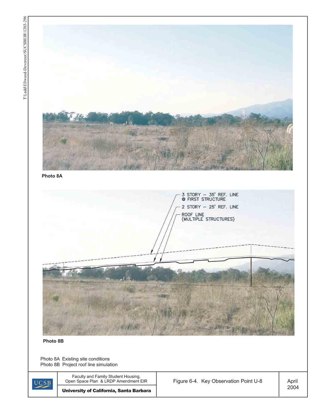
63