Geoplanner Applications. Aziz Bakkoury GIS Specialist City Planning Department City of Los Angeles
|
|
|
- Sheena Wells
- 5 years ago
- Views:
Transcription
1 Geoplanner Applications Aziz Bakkoury GIS Specialist City Planning Department City of Los Angeles
2 Major Planning Projects re:code LA : Updating the Zoning Code. General Plan update : Open Space Element. Community Plans Update : Guide to future developments. Planning for Transit Areas : Transit Oriented Communities.


3 UPDATING THE CODE 1946, first & last time zoning regulations were comprehensively revised

4 Unique neighborhoods with a variety of needs. Plan policies address issues that differ by neighborhood 2/3 of properties in the City of Los Angeles are regulated by multiple requirements layered on top of the base zoning. Multiple combinations of these layers make it difficult to understand the rules for development and use of property More on Re-code LA (

![[CONTEXT-FORM-FRONTAGE] [USE]](/docs-images/90/104345723/images/5-2.jpg "BUILT ENVIRONMENT RELATIONSHIP")
5 PROPOSED ZONING SYSTEM SETS CHARACTER BUILDING [CONTEXT-FORM-FRONTAGE] [USE] BUILT ENVIRONMENT RELATIONSHIP TO THE STREET ACTIVITY

6 PROPOSED ZONING SYSTEM CONTEXT Acknowledges that the City is made up of different types of neighborhoods [U-VG1-S][MXC] Identifies the over-arching character of the community o Downtown, Urban, Suburban, Rural, etc


7 PROPOSED ZONING SYSTEM FORM DISTRICT Identifies allowable development envelopes for buildings Four sets of metric-types Lot Criteria Building Placement Bulk & Mass Activation [U-VG1-S][MXC]

8 PROPOSED ZONING SYSTEM FRONTAGE Requirements for how site & building address the street: Transparency Story Height Pedestrian Access Building Elements [U-VG1-S][MXC]
9 PROPOSED ZONING SYSTEM USE DISTRICT Category system instead of enumerated list Permitted, Limited, Conditional Use Permit, or Not Permitted Clear use definitions & standards [U-VG1-S][MXC]

10 Recode Template

11
12 Community Plans Updates Community Plans provide the specific, neighborhood-level detail, relevant policies, and implementation strategies necessary to achieve the General Plan objectives. 1. Integrate land use, infrastructure and transportation improvement. 2. Direct growth to centers while preserving established residential neighborhoods. 3. Create healthier, more livable neighborhoods and economically vital business districts that can provide more jobs and housing opportunities for city residents.

13 Proposed Land Use Update

14


15

16

17

18

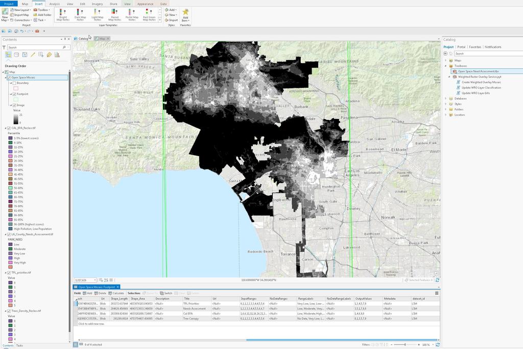
19
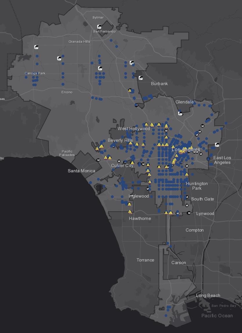
20 Transit Oriented Communities In Los Angeles Measure JJJ, approved by voters on November 8 th, provide multiple incentives for project areas located within one-half mile of a Major Transit Stop. Affordable housing requirements for projects that receive certain planning entitlements namely, general plan amendments or zone changes.
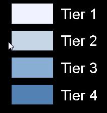
21 each one-half mile radius (2,640 feet) around a Major Transit Stop, as defined in the California Public Resources Code shall constitute a unique TOC Affordable Housing Incentive Area. Properties located within a TOC Affordable Housing Incentive Area are classified into Tiers (1-4) based on the shortest distance between any point on the lot and a qualified Major Transit Stop. The varying tiers provide 50-80% maximum increase on top of the allowable number of dwelling units permitted under the applicable zoning designation. TOC Guidelines:


22 GTFS (General Transit Feed Specification) data for all Metro, Los Angeles Department of Transportation (LADOT), Santa Monica Big Blue Bus, Culver City Municipal Bus Lines, and burbankbus. Used an R Script that uses the GTFS data and determines average headway of bus routes. Both directions of the bus line have to have 15 minutes or less headways for the line to qualify. Intersections were established as well as the addition of Metro Rail Portals, Metrolink Stations and rapid bus stops for those eligible line

23

24

25

26
27 General Plan Update: Open Space Element Comprehensive update to the General Plan. New 20-year citywide plan to be adopted in 2020 Provide best quality services and amenities to the population Covers topics such as: land use and economic development, water and energy conservation, parks and open space, air quality, historic preservation, public facilities and community assets.
28 Open Space Mosaic Layers Environmental Factors (Trust for Public Land Stacked Priority results): Climate Smart Cities Program Coastal High Hazard Areas, Flood Prone, Wetland, Employment density, Low-income population, High Quality Transit, Access to public schools, Best biking/walking Cal EPA Environ Scores (Office of Environmental Health Hazard Assessment) Air Quality Ozone, Drinking Water Contaminants, Pesticide Use, Toxic Releases from Facilities, Traffic Density, Groundwater Threats, Solid Waste Sites and Facilities, Asthma, Cardiovascular Disease, Educational Attainment, Housing Burden, Poverty, Unemployment Park Distribution (Los Angeles County Needs Assessment) Tree Canopy data
29

30

31

32