FOR SALE Pampa Ranch. 5,130.51± Acres Kern County, California. CA BRE # Exclusively Presented By: Pearson Realty
|
|
|
- Randall Brown
- 5 years ago
- Views:
Transcription


1 FOR SALE Pampa Ranch 5,130.51± Acres Kern County, California Exclusively Presented By: Pearson Realty Perimeter Fenced and Cross Fenced into 12 Pastures 2 Solar Powered Livestock Wells 16 APN Numbers 36 Water Troughs and 24 Water Tanks with 98,000± Gallon Storage CALIFORNIA S LARGEST AG BROKERAGE FIRM CA BRE #
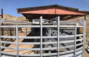
2 Pampa Ranch 5,130.51± Acres $4,617,000 LOCATION: DESCRIPTION: This substantial land opportunity is located east of Bakersfield, Ca in-between Breckenridge and Road Highway 58. Approximately 5± miles east of the Bakersfield, 120± miles north of Los Angeles, and 285± miles south of San Francisco. The Pampa Ranch is accessed from Edison Highway which turns into Bena Road as you go east, 4.5± miles east of the intersection of Bena Road and Tower Line Road go north (left) at a tank labeled Bena Corrals, proceed over rail road tracks follow the road to the left for 1¼± miles to the large metal gate. The well-appointed Pampa Ranch consists of 5,130.51± acres of contiguous gentle grazing land conveniently located just east of Bakersfield. The Owner has historically run yearlings with as many as 1,100± head of 4 weight cattle or 900± 5 weights, or it has supported 250± mother cows. The ranch is perimeter fenced and cross fenced into 12 pastures to maximize its use. Livestock water is provided from 2 solar powered wells and supplemented by a couple of springs. In the wet years the Pampa Ranch has stock ponds and access to Cottonwood Creek and Walker Basin Creek for cattle use. This sprawling cattle ranch boasts spectacular views of the surrounding mountains and valley. Surrounding land uses include but are not limited to; agricultural, rural home sites & life style, oil & gas, mining, recreation, mitigation, and open space. LEGAL: The land is zoned A (Exclusive Agricultural) and only APN s and are not enrolled in the Williamson Act. The ranch includes portions and/or all of Sections 23, 24, 25, 26, 27, 34, 35 & 36, Township 29S, Range 30E, MDB&M and Sections 1, 2 & 3, Township 30S, Range 30E, MDB&M Kern County, California. The Ranch consists of 16 APN s: , 02, 03 & 04, (7/8th fractional interest) & 18, and , 02, 03, 04, 05, 06, 09, 13, 16 & 17. SOILS: Improvements: WATER: PRICE/TERMS: (Ca. Rev. Storie Index): See attached Soil map. The owners have added corrals capable of handling any size group of cattle run through the ranch. They are permanent pipe and steel fencing except for less than 100 feet that still has Powder River Panels. The handling facility is improved with a complete Silencer Turret and lead up system with remote control gates and no backs. The Silencer chute is a complete scale. Additionally the ranch has a Powell electronic 15,000 lb scale. The Livestock water is provided from two solar powered wells and supplemented by a couple of springs. The water is delivered through 36 water troughs supplied by 24 water tanks with a one-time capacity of 98,000± gallons. Whenever possible the owner tried to put two separate sources of water to each pasture. In the wet years the Pampa Ranch has stock ponds and access to Cottonwood Creek and Walker Basin Creek for cattle use to supplement its developed wells and springs. $4,617,000 all cash to Seller at close of escrow. Seller will retain any remaining mineral rights and 50% of mining rights. CALIFORNIA S LARGEST AG BROKERAGE FIRM


3 Photos

4 Topography map Cottonwood Creek OUT Walker Basin Creek CALIFORNIA S LARGEST AG BROKERAGE FIRM
 California (CA668) Map unit symbol Map unit name Rating Component name")
 Calcic Haploxerepts (40%) Grade 1 - Excellent Chanac (30%) 205 Pleito-Trigo-Chanac Grade 2 - Good Pleito")
 264 Arujo-Walong-Tunis Grade 4 - Poor Walong (25%) association, 9 to 30 percent slopes Tunis (20%) 267 Cieneba-Vista-Rock outcrop complex, 30")
 Walong (20%) 296 Arujo-Walong-Tunis association, 30 to 75 percent slopes Grade 3 - Fair Arujo (40%) 305 Chanac-Pleito- Premier association, 20 to 60")
 Grade 1 - Excellent Premier (85%) Percent of AOI 1.4% 0.2% 3.3% 0.7% 8.1% 60.1% 0.6% 13.")
5 soil map OUT California Revised Revised Storie Storie Index (CA) Index Summary (CA) Summary by Map Unit by Kern Map County, Unit Northeastern Kern County, Part, Nort and Southeastern Part of Tulare County, Tulare California County, (CA668) California (CA668) Map unit symbol Map unit name Rating Component name (percent) 174 Xeric Torriorthents- Calcic Haploxerepts association, 15 to 60 percent slopes Grade 3 - Fair 201 Pleito-Chanac- Raggulch complex, 5 to 30 percent slopes Xeric Torriorthents, silty (45%) Calcic Haploxerepts (40%) Grade 1 - Excellent Chanac (30%) 205 Pleito-Trigo-Chanac Grade 2 - Good Pleito (40%) complex, 15 to 50 percent slopes Chanac (20%) 261 Blasingame-Arujo- Cieneba association, 15 to 45 percent slopes Grade 4 - Poor Blasingame (30%) Cieneba (25%) 264 Arujo-Walong-Tunis Grade 4 - Poor Walong (25%) association, 9 to 30 percent slopes Tunis (20%) 267 Cieneba-Vista-Rock outcrop complex, 30 to 60 percent slopes Grade 5 - Very Poor Cieneba (40%) 277 Feethill-Vista- Walong association, 15 to 60 percent slopes Grade 4 - Poor Feethill (30%) Vista (25%) Walong (20%) 296 Arujo-Walong-Tunis association, 30 to 75 percent slopes Grade 3 - Fair Arujo (40%) 305 Chanac-Pleito- Premier association, 20 to 60 percent slopes Grade 3 - Fair Chanac (45%) Pleito (20%) 316 Premier coarse sandy loam, 5 to 9 percent slopes 317 Premier coarse sandy loam, 2 to 5 percent slopes Totals for Area of Interest Grade 1 - Excellent Premier (85%) Grade 1 - Excellent Premier (85%) Percent of AOI 1.4% 0.2% 3.3% 0.7% 8.1% 60.1% 0.6% 13.4% 6.6% 4.1% 1.6% 100.0%
6 apn maps CALIFORNIA S LARGEST AG BROKERAGE FIRM


7 OUT


8 LOCATION MAP Rio Bravo Country Club Bena Rd 184 Towerline Rd 4.5± miles Tank Bena Corrals General Beale Rd REGIONAL Map 99 We believe the information contained herein to be correct. It is obtained from sources which we regard as reliable, but we assume no liability for errors or omissions. Policy on cooperation: All real estate licensees are invited to offer this property to prospective buyers. Do not offer to other agents without prior approval. Offices Serving The Central Valley FRESNO VISALIA BAKERSFIELD 7480 N Palm Ave, Ste S Demaree Street 1801 Oak Street, Ste 159 Fresno, CA Visalia, CA Bakersfield, CA Download Our Mobile App!