Ontario Ministry of the Environment - Record of Site Condition # Record of Site Condition Under Part XV.1 of the Environment Protection Act 1Z7
|
|
|
- Logan Russell
- 5 years ago
- Views:
Transcription
1 Ontario Ministry of the Environment - Record of Site Condition # Record of Site Condition Under Part XV.1 of the Environment Protection Act Summary Record of Site Condition Number Date Filed to Environmental Site Registry 13/05/2013 Certification Date 07/03/2013 Current Property Use Commercial Intended Property Use Institutional Certificate of Property Use Number Applicable Site Condition Standards** Property Municipal Address No CPU Full Depth Generic Site Conditions Standard, with Non-potable Ground Water, Medium and Fine Textured Soil, for Institutional property use 4 Cataraqui Street, Woolen Mill, East Wing K7K 1Z7 Notice to Readers Concerning Due Diligence This record of site condition has been filed in the Environmental Site Registry to which the public has access and which contains a notice advising users of the Environmental Site Registry who have dealings with any property to consider conducting their own due diligence with respect to the environmental condition of the property, in addition to reviewing information in the Environmental Site Registry. Contents of this Record of Site Condition This record of site condition consists (RSC) of this document which is available to be printed directly from the Environmental Site Registry as well as all supporting documentation indicated in this RSC to have been submitted in electronic format to the Ministry of the Environment.
2 RSC Information Each field marked by an asterisk (* ) must be completed. Is the property used, or has it ever been used, in whole or in part for an industrial use or as a garage; a bulk liquid dispensing facility, including a gasoline outlet; or for the operation of dry cleaning equipment? Yes * No During a phase one environmental site assessment of the property, was a potentially contaminating activity identified on, in or under the property? Yes * No Are there potentially contaminating activities identified in the current RSC submission that were not identified in a previous Phase 1 ESA Report in support of a RSC filed for the property? * Yes No Is there an area of potential environmental concern? Yes * No Select Type of RSC * Phase 1 and 2 RSC Phase 1 and 2 RSC with RA
3 Owners' General Information Submitting Owner's Information Owner's Agent Information Owner's Information Owners' General Information Is the submitting owner(s) a Receiver for the Property? * Yes No Is the submitting owner(s) represented by an Agent? * Yes No
4 Owners' General Information Submitting Owner's Information Owner's Agent Information Owner's Information Submitting Owner's Information Type of Owner * Owner Name * Firm, Corporation or Partnership ABNA Investments Ltd. Street Number 588 * Street Name * Apt No. /RR No. Scotland Road R.R. #1 City, Town or Village * Province * Postal Code * Country Odessa Ontario K0H 2H0 Submitting Owner's Contact Information Contact First Name * Contact Last Name * Hank Doornekamp Phone Number * (including area code) Fax Number (including area code) Address (613)
5 Owners' General Information Submitting Owner's Information Owner's Agent Information Owner's Agent Information Owner's Agent Information Agent First Name * Agent Middle Name Agent Last Name * Kevin Shipley Street Number * Street Name * Apt No. /RR No. 6 Cataraqui Street, Woolen Mill, West Wing Suite 105 City, Town or Village * Province * Postal Code * Kingston Ontario K7K 1Z7 Owner's Agent Contact Information Phone Number * (including area code) Fax Number (including area code) Address (613)
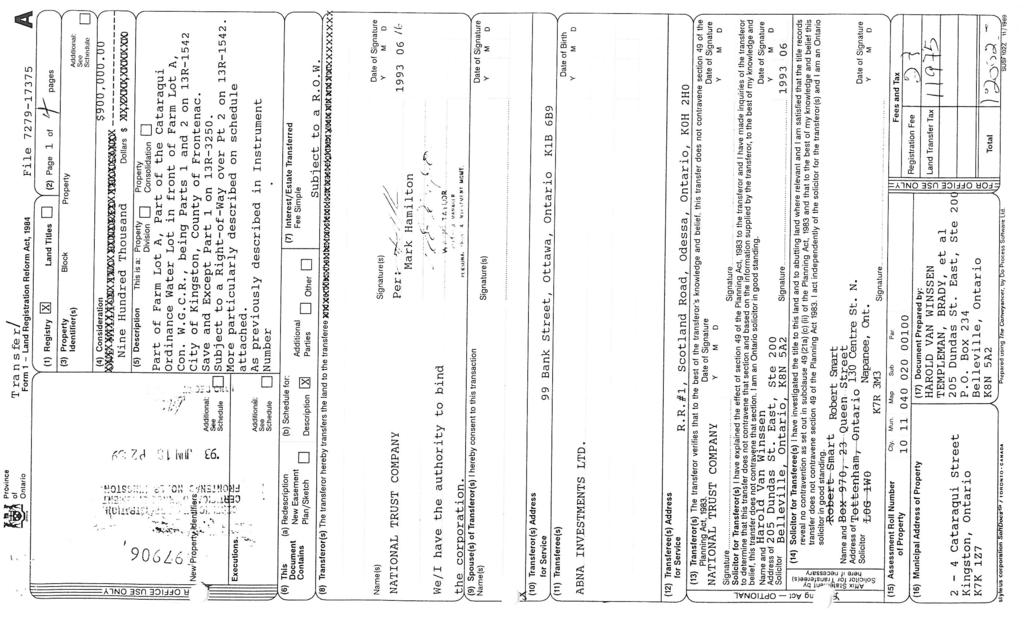
6 Property Address Municipality Information Property Address Does the Property have a Municipal Address? Yes No * Property Reference Number Geographical Reference/Area of RSC Property Is the property administered by MNR under the Public Lands Act? Yes No * Previously Filed RSC(s) and TN(s) Street Number * Street Name * 4 Cataraqui Street, Woolen Mill, East Wing City, Town or Village * Province * Kingston Ontario Apt No. /RR No. Postal Code * K7K 1Z7
7 Property Address Municipality Information Property Reference Number Geographical Reference/Area of RSC Property Previously Filed RSC(s) and TN(s) Municipality & Property Address Information Municipality Information Lower or Single Tier Municipality * Kingston Tier of Municipality Single Tier The District Office of MOE * Kingston District Office Address of District Office of MOE Box 22032, 1259 Gardiners Road, Kingston ON K7M 8S5 Click here to view the list of municipalities
8 Property Address Municipality Information Property Reference Number Geographical Reference/Area of RSC Property Municipality & Property Address Information Property Reference Number Assessment Roll Number Property Identifier Number (PIN #) (LT) Previously Filed RSC(s) and TN(s)
9 Property Address Municipality Information Property Reference Number Geographical Reference/Area of RSC Property Previously Filed RSC(s) and TN(s) Geo Reference & Other Properties Details Geographical References UTM Coordinates Datum NAD 83 Zone * 18 Easting * 381, Northing * 4,899, Area of RSC Property Total Area of RSC Property in Hectares *.096
10 Previous Submission Information Previously Filed Record of Site Condition Number: Property Address Municipality Information Property Reference Number Previously Filed Transition Notice Number: Geographical Reference/Area of RSC Property Previously Filed RSC(s) and TN(s)
11 Other Site Condition Information Site Conditions for 2011 Generic Standards Risk Assessment Information Property Use and Certification Date Additional Ground Water Information Remedial Action and Mitigation Details Area(s) of Potential Environmental Concern Table of Current/Past Property Uses of Phase One Property Site Condition Information Other Site Condition Information Is the RSC being submitted using the transition provision under Section 21.1 of the Regulation? Yes No *
12 Other Site Condition Information Site Conditions for 2011 Generic Standards Risk Assessment Information Property Use and Certification Date Additional Ground Water Information Remedial Action and Mitigation Details Area(s) of Potential Environmental Concern Site Condition Information Site Conditions for 2011 Generic Standards Is Property: (i) Within an area of natural significance? or Does Property: (ii) Include or is adjacent to an area of natural significance or part of such an area? or (ii) Include land that is within 30 m of an area of natural significance or part of such an area. Yes No Soil at the property has: (i) a ph value for Surface Soil less than 5 or greater than 9 or (ii) a ph value for Subsurface Soil less than 5 or greater than 11. Yes No * * Table of Current/Past Property Uses of Phase One Property Is qualified person of the opinion that, given the characteristics of the property and the certifications the qualified person would be required to make in a record of site condition in relation to the property as specified in Schedule A, it is appropriate to apply this section to the property? * Yes No What is the intended use of the property? * Institutional Is the property a shallow soil property? * Yes No Does the property include or is the property adjacent to a water body or does it include land that is within 30 metres of a water body? * Yes No What is the Assessment/Restoration approach? Background * Full Depth Generic Stratified What is the ground water condition for the property? Potable * Non-potable What is the texture of the soil? Coarse * Medium and Fine Applicable 2011 Generic Standard Table Number : TABLE 3
13 Other Site Condition Information Risk Assessment Information Has a Certificate of Property Use (CPU) been issued under section of the Act for the RSC property? Yes No Site Conditions for 2011 Generic Standards Risk Assessment Information Property Use and Certification Date Additional Ground Water Information Remedial Action and Mitigation Details Area(s) of Potential Environmental Concern Table of Current/Past Property Uses of Phase One Property
14 Other Site Condition Information Site Conditions for 2011 Generic Standards Property Use and Certification Date Current Property Use and Certification Date What is the current use of the property? * Commercial Certification Date * 2013/03/07 Risk Assessment Information Property Use and Certification Date Additional Ground Water Information Remedial Action and Mitigation Details Area(s) of Potential Environmental Concern Table of Current/Past Property Uses of Phase One Property
15 Other Site Condition Information Site Conditions for 2011 Generic Standards Risk Assessment Information Property Use and Certification Data Additional Ground Water Information Remedial Action and Mitigation Details Area(s) of Potential Environmental Concern Table of Current/Past Property Uses of Phase One Property Site Condition Information Additional Ground Water Information Has municipality been notified of non-potable ground water on site? Yes No Municipality notified of non-potable water by? * Owner QP Local/Lower tier municipality non-potable water notification date * 2013/04/01 *
16 Other Site Condition Information Site Conditions for 2011 Generic Standards Remedial Action & Mitigation Soil Control or Treatment Measures Identify the estimated quantities of the soil, if any, originating at and remaining on the RSC property that have been remediated, at a location either on or off the property, to reduce the concentration of contaminants in the soil as measured in, or equivalent to, in-ground volume in cubic metres, and indicate the remediation process or processes used and the estimated amount of soil remediated by each identified process. Risk Assessment Information Property Use and Certification Data Additional Ground Water Information Identify the estimated quantities of soil or sediment, if any, removed from and not returned to the RSC property as measured in, or equivalent to, the in-ground volume in cubic metres. Remedial Action and Mitigation Details Area(s) of Potential Environmental Concern Table of Current/Past Property Uses of Phase One Property Identify the estimated quantity of the soil, if any, being brought from another property to and deposited at the RSC property, not including any soil that may have originated at but been remediated off the RSC property not including any soil that may have been remediated off the property and brought back to the property as measured in, or equivalent to, the in-ground volume in cubic metres. Indicate if any soil, sediment or ground water at the RSC property that is or was located within 3 metres of the RSC property boundary has been remediated or removed for the purpose of remediation.
17 Other Site Condition Information Site Conditions for 2011 Generic Standards Remedial Action & Mitigation Ground Water Control or Treatment Measures Identify and describe any ground water control or treatment measures that were required for the RSC property prior to the certification date for the purpose of submitting the RSC for filing; or are or will be required for the RSC property after the certification date. Risk Assessment Information Property Use and Certification Data Additional Ground Water Information Identify the estimated volume in litres of ground water, if any, removed from and not returned to the RSC property. Remedial Action and Mitigation Details Area(s) of Potential Environmental Concern Table of Current/Past Property Uses of Phase One Property Other Treatment Measures Other than the activities identified in the in the Soil or Ground Water Control or Treatment Measures above, identify any constructed works that, prior to the certification date for the purpose of submitting the RSC for filing, were required to control or otherwise mitigate the release or movement of known existing contaminants at the RSC property; or after the certification date, are required to control or otherwise mitigate the release or movement of known existing contaminants at the RSC property. Indicate whether there are any monitoring requirements or any requirements for care, maintenance or replacement of any monitoring or control works for known existing contaminants, if any, on the RSC property, after the certification date, and whether any monitoring requirements or requirements for care, maintenance or replacement of any monitoring or control works are ground water management measures or soil management measures.
18 Other Site Condition Information Site Conditions for 2011 Generic Standards Risk Assessment Information Property Use and Certification Data Additional Ground Water Information Potential Environmental Concern Area(s) of Potential Environmental Concern Are there areas of potential environmental concern? * Yes No Click here for Area(s) of Potential Environmental Concern Form Current and Past Property Use Table of Current and Past Uses of the Phase One Property Click here for Table of Current and Past Property Use Form Remedial Action and Mitigation Details Area(s) of Potential Environmental Concern Table of Current/Past Property Use of Phase One Property
19 Contaminants Measured in SOIL Contaminants Measured in GROUND WATER Contaminants Measured in SEDIMENTS Contaminants Measured in SOIL General Information Related to Soil Media Is there no soil on, in or under the property? * (Note there is no soil if either there is no soil on, in or under the property OR the soil present is not sufficient to investigate, sample and analyze in a manner which will meet the requirements and objectives of a phase two environmental site assessment) Yes No
20 Contaminants Measured in SOIL Contaminants Measured in GROUND WATER Contaminants Measured in SEDIMENTS Contaminants Measured in SOIL Measured Concentration for Contaminants in Soil Contaminant 1-30 * Type of Measurement * Measured * Applicable Concentration Standard Unit Of Measure Antimony Minimum Detectable µg/g Arsenic Measured µg/g Barium Measured µg/g Beryllium Measured µg/g Boron (total) Measured µg/g Boron (Hot Water Soluble)* Measured µg/g Cadmium Measured µg/g Chromium Total Measured µg/g Chromium VI Minimum Detectable µg/g Cobalt Measured µg/g Copper Measured µg/g Lead Measured µg/g Mercury Measured µg/g Molybdenum Measured µg/g Nickel Measured µg/g Selenium Measured µg/g Silver Measured µg/g Thallium Measured µg/g Uranium Measured µg/g Vanadium Measured µg/g Zinc Measured µg/g Acetone Minimum Detectable µg/g Benzene Minimum Detectable µg/g Bromodichloromethane Minimum Detectable µg/g Bromoform Minimum Detectable µg/g Bromomethane Minimum Detectable µg/g Carbon Tetrachloride Minimum Detectable µg/g Chlorobenzene Minimum Detectable µg/g Chloroform Minimum Detectable µg/g Dibromochloromethane Minimum Detectable µg/g Total # of Contaminants 81
21 Contaminants Measured in SOIL Contaminants Measured in GROUND WATER Contaminants Measured in SEDIMENTS Contaminants Measured in SOIL Measured Concentration for Contaminants in Soil Contaminant * Type of Measurement * Measured * Applicable Concentration Standard Unit Of Measure Dichlorobenzene, 1,2- Minimum Detectable µg/g Dichlorobenzene, 1,3- Minimum Detectable µg/g Dichlorobenzene, 1,4- Minimum Detectable µg/g Dichlorodifluoromethane Minimum Detectable µg/g Dichloroethane, 1,1- Minimum Detectable µg/g Dichloroethane, 1,2- Minimum Detectable µg/g Dichloroethylene, 1,1- Minimum Detectable µg/g Dichloroethylene, 1,2-cis- Minimum Detectable µg/g Dichloroethylene, 1,2-trans- Minimum Detectable µg/g Dichloropropane, 1,2- Minimum Detectable µg/g Dichloropropene,1,3- Minimum Detectable µg/g Ethylbenzene Minimum Detectable µg/g Ethylene dibromide Minimum Detectable µg/g Hexane (n) Minimum Detectable µg/g Methyl Ethyl Ketone Minimum Detectable µg/g Methyl Isobutyl Ketone Minimum Detectable µg/g Methyl tert-butyl Ether (MTBE) Minimum Detectable µg/g Methylene Chloride Minimum Detectable µg/g Styrene Minimum Detectable µg/g Tetrachloroethane, 1,1,1,2- Minimum Detectable µg/g Tetrachloroethane, 1,1,2,2- Minimum Detectable µg/g Tetrachloroethylene Minimum Detectable µg/g Toluene Minimum Detectable µg/g Trichlorobenzene, 1,2,4- Minimum Detectable µg/g Trichloroethane, 1,1,1- Minimum Detectable µg/g Trichloroethane, 1,1,2- Minimum Detectable µg/g Trichloroethylene Minimum Detectable µg/g Trichlorofluoromethane Minimum Detectable µg/g Vinyl Chloride Minimum Detectable µg/g Xylene Mixture Minimum Detectable µg/g Total # of Contaminants 81
22 Contaminants Measured in SOIL Contaminants Measured in GROUND WATER Contaminants Measured in SEDIMENTS Contaminants Measured in SOIL Measured Concentration for Contaminants in Soil Contaminant * Type of Measurement * Measured * Applicable Concentration Standard Unit Of Measure Petroleum Hydrocarbons F1**** Minimum Detectable µg/g Petroleum Hydrocarbons F2 Minimum Detectable µg/g Petroleum Hydrocarbons F3 Measured µg/g Petroleum Hydrocarbons F4 Minimum Detectable µg/g Acenaphthene Minimum Detectable µg/g Acenaphthylene Minimum Detectable µg/g Anthracene Minimum Detectable µg/g Benz[a]anthracene Minimum Detectable µg/g Benzo[a]pyrene Minimum Detectable µg/g Benzo[b]fluoranthene Minimum Detectable µg/g Benzo[ghi]perylene Minimum Detectable µg/g Benzo[k]fluoranthene Minimum Detectable µg/g Chrysene Minimum Detectable µg/g Dibenz[a h]anthracene Minimum Detectable µg/g Fluoranthene Minimum Detectable µg/g Fluorene Minimum Detectable µg/g Indeno[1 2 3-cd]pyrene Minimum Detectable µg/g Methlynaphthalene, 2-(1-) *** Minimum Detectable µg/g Naphthalene Minimum Detectable µg/g Phenanthrene Minimum Detectable µg/g Pyrene Minimum Detectable µg/g Total # of Contaminants 81
23 Contaminants Measured in SOIL Contaminants Measured in GROUND WATER Contaminants Measured in SEDIMENTS Contaminants Measured in Ground Water Has ground water sampling been conducted at the property? Yes No Measured Concentration for Contaminants in Ground Water Contaminant 1-30 * Type of Measurement * * Measured * Applicable Concentration Standard Unit Of Measure Antimony Minimum Detectable µg/l Arsenic Minimum Detectable µg/l Barium Measured µg/l Beryllium Minimum Detectable µg/l Boron (total) Measured µg/l Cadmium Minimum Detectable µg/l Chromium Total Minimum Detectable µg/l Chromium VI Minimum Detectable µg/l Cobalt Measured µg/l Copper Measured µg/l Lead Minimum Detectable µg/l Mercury Minimum Detectable µg/l Molybdenum Measured µg/l Nickel Measured µg/l Selenium Measured µg/l Silver Minimum Detectable µg/l Thallium Minimum Detectable µg/l Uranium Measured µg/l Vanadium Measured µg/l Zinc Minimum Detectable 5 1 µg/l Acetone Minimum Detectable µg/l Benzene Minimum Detectable µg/l Bromodichloromethane Minimum Detectable µg/l Bromoform Minimum Detectable µg/l Bromomethane Minimum Detectable µg/l Carbon Tetrachloride Minimum Detectable µg/l Chlorobenzene Minimum Detectable µg/l Chloroform Minimum Detectable 1 22 µg/l Dibromochloromethane Minimum Detectable µg/l Dichlorobenzene, 1,2- Minimum Detectable µg/l Total # of Contaminants 80
24 Contaminants Measured in SOIL Contaminants Measured in GROUND WATER Contaminants Measured in SEDIMENTS Contaminants Measured in Ground Water Measured Concentration for Contaminants in Ground Water Contaminant * Type of Measurement * Measured * Applicable Concentration Standard Unit Of Measure Dichlorobenzene, 1,3- Minimum Detectable µg/l Dichlorobenzene, 1,4- Minimum Detectable µg/l Dichlorodifluoromethane Minimum Detectable µg/l Dichloroethane, 1,1- Minimum Detectable µg/l Dichloroethane, 1,2- Minimum Detectable µg/l Dichloroethylene, 1,1- Minimum Detectable µg/l Dichloroethylene, 1,2-cis- Minimum Detectable µg/l Dichloroethylene, 1,2-trans- Minimum Detectable µg/l Dichloropropane, 1,2- Minimum Detectable µg/l Dichloropropene,1,3- Minimum Detectable µg/l Ethylbenzene Minimum Detectable µg/l Ethylene dibromide Minimum Detectable µg/l Hexane (n) Minimum Detectable µg/l Methyl Ethyl Ketone Minimum Detectable µg/l Methyl Isobutyl Ketone Minimum Detectable µg/l Methyl tert-butyl Ether (MTBE) Minimum Detectable µg/l Methylene Chloride Minimum Detectable µg/l Styrene Minimum Detectable µg/l Tetrachloroethane, 1,1,1,2- Minimum Detectable µg/l Tetrachloroethane, 1,1,2,2- Minimum Detectable µg/l Tetrachloroethylene Minimum Detectable µg/l Toluene Minimum Detectable µg/l Trichlorobenzene, 1,2,4- Minimum Detectable µg/l Trichloroethane, 1,1,1- Minimum Detectable µg/l Trichloroethane, 1,1,2- Minimum Detectable µg/l Trichloroethylene Minimum Detectable µg/l Trichlorofluoromethane Minimum Detectable µg/l Vinyl Chloride Minimum Detectable µg/l Xylene Mixture Minimum Detectable µg/l Petroleum Hydrocarbons F1**** Minimum Detectable µg/l Total # of Contaminants 80
25 Contaminants Measured in SOIL Contaminants Measured in GROUND WATER Contaminants Measured in SEDIMENTS Contaminants Measured in Ground Water Measured Concentration for Contaminants in Ground Water Contaminant * Type of Measurement * Measured * Applicable Concentration Standard Unit Of Measure Petroleum Hydrocarbons F2 Minimum Detectable µg/l Petroleum Hydrocarbons F3 Minimum Detectable µg/l Petroleum Hydrocarbons F4 Minimum Detectable µg/l Acenaphthene Minimum Detectable µg/l Acenaphthylene Minimum Detectable µg/l Anthracene Minimum Detectable µg/l Benz[a]anthracene Minimum Detectable µg/l Benzo[a]pyrene Minimum Detectable µg/l Benzo[b]fluoranthene Minimum Detectable µg/l Benzo[ghi]perylene Minimum Detectable µg/l Benzo[k]fluoranthene Minimum Detectable µg/l Chrysene Minimum Detectable µg/l Dibenz[a h]anthracene Minimum Detectable µg/l Fluoranthene Minimum Detectable µg/l Fluorene Minimum Detectable µg/l Indeno[1 2 3-cd]pyrene Minimum Detectable µg/l Methlynaphthalene, 2-(1-) *** Minimum Detectable µg/l Naphthalene Minimum Detectable µg/l Phenanthrene Minimum Detectable µg/l Pyrene Minimum Detectable µg/l Total # of Contaminants 80
26 Contaminants Measured in SOIL Contaminants Measured in GROUND WATER Contaminants Measured in SEDIMENTS Contaminants Measured in Sediments Has sediment sampling been conducted at the property? Yes No *
27 Contaminants Measured in SOIL Contaminants Measured in GROUND WATER Contaminants Measured in SEDIMENTS Laboratory Information Laboratory Name * Caduceon Environmental Laboratories
28 Phase One ESA Reports Phase Two ESA Reports Phase One Reports and Other Documents ESA Reports Phase One ESA Reports The date the last work on the records review, interviews and site reconnaissance components of the phase one environmental site assessment was done. 2013/03/28 * Type of Report * Report Title * Date of Report* Author of Report * Name of Consulting Organization Phase One ESA Phase One Envi 2013/04/02 Natalia Baranova a XCG Consultants Limit Phase Two Reports and Other Documents
29 Phase One ESA Reports Phase Two ESA Reports Phase One Reports and Other Documents ESA Reports Phase Two ESA Reports The date the last work on the planning of the site investigation and conducting the site investigation components of the phase two environmental site assessment was done. 2013/05/06 * Type of Report * Report Title * Date of Report* Author of Report * Name of Consulting Organization Phase Two ESA Phase Two Envir 2013/05/06 Kevin Shipley XCG Consultants Limit Phase Two Reports and Other Documents
30 Phase One ESA Reports Phase Two ESA Reports Reports and Other Documents Phase 1 Reports and Other Documents List the Reports/Documents other than the document(s) used as your Phase 1 ESA relied on in certifying the information set out in Section 10 of Schedule A or otherwise used in conducting the Phase 1 ESA Report Title* Date of Report* Author of Report * Phase I Environmental Site Assessment, Th 2001/05/03 Name of Consulting Organization for Report Donald Munro and Oliver, Mangione, McCalla & Phase One Reports and Other Documents Phase Two Reports and Other Documents
31 Phase One ESA Reports Reports and Other Documents Phase 2 Reports and Other Documents List the Reports/Documents other than the document(s) used as your Phase 2 ESA relied on in making any certifications in the RSC in relation to the Phase 2 ESA or otherwise used in conducting the Phase 2 ESA Report Title Date of Report Author of Report Name of Consulting Organization for Report Phase Two ESA Reports Phase One Reports and Other Documents Phase Two Reports and Other Documents
32 QP Information First Name * Middle Name Last Name * Kevin Which one of the following licences under the Professional Engineers Act do you hold? * Licence Which one of the following memberships under the Professional Geoscientists Act do you hold? * Shipley Licence Number * QP Information Is the QP Employed? * Employer Name * Yes XCG Consultants Limited No QP Contact Information Phone Number * Fax Number * * (613) (613) kevins@xcg.com QP Mailing Address Information Street Number * Street Name * Apt No. / RR No. 6 Cataraqui Street, Woolen Mill, West Wing Suite 105 City, Town or Village * Province * Postal Code * Kingston Ontario K7K 1Z7
33 QP Owner QP D As the qualified person, I certify that: * A phase one environmental site assessment of the RSC property, which includes the evaluation of the information gathered from a records review, site reconnaissance, interviews, a report and any updates required, has been conducted in accordance with the regulation by or under the supervision of a qualified person as required by the regulation. A phase two environmental site assessment of the RSC property, which includes the evaluation of the information gathered from planning and conducting a site investigation, a report, and any updates required, has been conducted in accordance with the regulation by or under the supervision of a qualified person as required by the regulation. The information represents the site conditions at the sampling points at the time of sampling only and the conditions between and beyond the sampling points may vary. As of 2013/03/07, in my opinion, based on the phase one environmental site assessment and the phase two environmental site assessment, and any confirmatory sampling, there is no evidence of any contaminants in the soil, ground water or sediment on, in or under the RSC property that would interfere with the type of property use to which the RSC property will be put, as specified in the RSC. Ground water sampling has been conducted in accordance with the regulation by or under the supervision of a qualified person as required by the regulation. I have, within the six months immediately before the submission of this record of site condition, given written notice of intention to apply non-potable ground water site condition standards to the clerk of the local municipality in which the property is located and the clerk of any upper-tier municipality in which the property is located. As of 2013/03/07, in my opinion, based on the phase one and phase two environmental site assessments and any confirmatory sampling, the RSC property meets the applicable full depth generic site condition standards prescribed by section 37 of the regulation for all contaminants prescribed by the regulation in relation to the type of property use for which this RSC is filed, except for those contaminants (if any) specified in this RSC at Table 2, Maximum Compared to Standards Specified in a Risk Assessment. As of 2013/03/07, the maximum known concentration of each contaminant in soil, sediment and ground water at the RSC property for which sampling and analysis has been performed is specified in this RSC at Table 1, Maximum Compared to Applicable Site Condition Standards. I am a qualified person and have the qualifications required by section 5 of the regulation. I have in place an insurance policy that satisfies the requirements of section 7 of the regulation. I acknowledge that the RSC will be submitted for filing in the Environmental Site Registry, that records of site condition that are filed in the Registry are available for examination by the public and that the Registry contains a notice advising users of the Registry who have dealings with any property to consider conducting their own due diligence with respect to the environmental condition of the property, in addition to reviewing information in the Registry. The opinions expressed in this RSC are engineering or scientific opinions made in accordance with generally accepted principles and practices as recognized by members of the environmental engineering or science profession or discipline practising at the same time and in the same or similar location. I do not hold and have not held a direct or indirect interest in the RSC property or any property which includes the RSC property and was the subject of a phase one or two environmental site assessment or risk assessment upon which this record of site condition is based To the best of my knowledge, the certifications and statements in this part of the RSC are true as of 2013/03/07. By signing this RSC, I make no express or implied warranties or guarantees. I, the qualified person named below, on the date stated below, make all of the stated certifications applicable to the qualified person in this Part of the record of site condition. Kevin Shipley 2013/05/08
34 Owner Click here to download Agent Form QP Owner
35 Please note, only PDF attachments will be accepted with the exception of the Property Specific Standard, which must be an Excel document. Certificate of Status or equivalent Certificate of Status ABNA May 2013.pdf Proof of the owner s authorization * * Authorization letter revised 3 May 2013.PDF Lawyer s letter consisting of a legal description of the property Revised Lawyer Letter.pdf Copy of any deed(s), transfer(s) or other document(s) * Deed or Transfer of Land.pdf * A Current plan of Survey * Highlighted legal survey.pdf Area(s) of Potential Environmental Concern * Areas of Potential Environmental Concern rev.pdf Table of Current and Past Uses of the Phase One Property * Table of Current and Past Uses rev 23 Apr 2013.pdf Phase 2 Conceptual Site Model * Phase Two Conceptual Site Model (May 6, 2013).pdf Owner * Agent Certification Woolen Mill rev.pdf
36


37


38
39
40
41
42

43
44
45 TABLE OF AREAS OF POTENTIAL ENVIRONMENTAL CONCERN (Refer to clause 16(2)(a), Schedule D, O. Reg. 153/04) Area of Potential Environmental Concern 1 Potential presence of fill material of unknown quality beneath footprint of East Wing on Phase One Property Location of Area of Potential Environmental Concern on Phase One Property East Wing Footprint Potentially Contaminating Activity 2 Location of PCA (on site or offsite) Contaminants of Potential Concern 3 #30. Importation of Fill On Site Metals, PAHs, VOCs, PHCs F1 Material of Unknown Quality F4 Media Potentially Impacted (Ground water, soil and/or sediment) Groundwater and soil Area of existing hydraulic Adjacent to the hydraulic elevator in Woolen Mill elevator in the portion of the building adjacent to Phase One Woolen Mill adjacent to the Property Phase One Property Area of historic freight elevator in Woolen Mill building adjacent to Phase One Property Operation of a boiler in the Woolen Mill building southwest of the Phase One Adjacent to the historical elevator in the portion of the Woolen Mill adjacent to the Phase One Property Boiler Room southwest of the Phase One Property #28. Gasoline and Associated Products Storage in Fixed Tanks #28. Gasoline and Associated Products Storage in Fixed Tanks #28. Gasoline and Associated Products Storage in Fixed Tanks Off site VOCs, PHCs F1 F4, Metals Groundwater and soil Off site VOCs, PHCs F1 F4, Metals Groundwater and soil Off site Metals, PAHs, VOCs, PHCs F1 F4 Groundwater
46 TABLE OF CURRENT AND PAST USES OF THE PHASE ONE PROPERTY (Refer to clause 16(2)(b), Schedule D, O. Reg. 153/04) Year Name of Owner Description of Property Use Property Use 1 Photographs, Fire Insurance Plans, Etc. Other Observations from from Aerial Prior to 1874 Unknown Vacant residential/ agricultural Agricultural or Residential No additional information available Kingston & Pembroke Railway Company (leased from the Unknown Agricultural or Residential No additional information available Queen) Kingston Cotton Mills Textile (Cotton) Manufacturing Industrial Woolen Mill building constructed in 1881/ Dominion Cotton Mills Company Ltd. Textile (Cotton) Manufacturing Industrial Dominion Textile Company Textile (Cotton) Manufacturing Industrial 1931 Corporation of the City of Kingston Building not in use Industrial Heild Brothers Ltd. Textile (Wood) Manufacturing Industrial The building was repurposed for wool manufacturing St. Francis Development (leased to Kingston Spinners) Carpet Fibre Manufacturing Industrial St. Francis Development; various tenants including tradespeople and manufacturing Various Industrial The building was subdivided in various areas for multi tenant occupancy Wilf and Mary Eagle, John Hanson; various tenants including tradespeople, manufacturing and offices Various including blacksmithing, woodworking, sail making and restaurant Industrial The building was subdivided in various areas for multi tenant occupancy 1993 present ABNA Investments; various tenants Offices, restaurant, gym Commercial Additions were made including two levels above the east end of the East Wing (River Mill restaurant) and two levels above the boiler room
47 Phase Two Conceptual Site Model, 4 Cataraqui Street, Kingston, Ontario PHASE TWO CONCEPTUAL SITE MODEL Phase Two Conceptual Site Model As discussed in Section 3.3, a CSM was prepared during the Phase One ESA. The PCAs identifiedd in the Phase One Study Area during the Phase One ESA are shown on Figure 3 included in Appendix A. The APECs identified at the Phase Two Property during the Phase One ESA are shown on Figure 4 in Appendix A and presented in Table A at the end of text. The APECs identified during the Phase One ESA were investigated in the Phase Two ESA. Figure 1 in Appendix A illustrates the building identified at the Phase Two Property. During the Phase Two ESA activities, the stratigraphy at the Phase Two Property was determined to generally consist of a concretee floor slab and sub-slabb fill underlain by a silty clay and silt shallow groundwater unit. The location of cross-section A-A is shown on Figure 2 in Appendix B, and the stratigraphy of the Phase Two Property is shown in the cross-section on Figure 3 in Appendix B. The cross-section also includes groundwater elevations. Well construction details are shown on the borehole logs included in Appendix C. The average horizontal gradient for the shallow groundwater unit is The depth to groundwater was measured between 2.09 and 2.96 m bgs. The interpreted groundwater elevations measured on March 7, 2013 and May 6, 2013,, are shown on Figure 4 in Appendix B. Bedrock was not encountered during the Phase Two ESA. The Phase Two Property is not designated as a sensitive site with respect to Sections 411 or 43.1 of O. Reg. 153/04, as amended. No soil has been brought from another property to the Phase Two Property. There are no proposed changes to the on-site building with exception of interior renovations. The Phase Two ESA pictorial CSM is presented in Figure 5 in Appendix B and includes the release mechanisms, transport pathway, human and ecological receptors, receptor exposure points, and routes of exposure related to investigated APECs at the Phase Two Property. Based on the findings of the Phase Two ESA, no COCs were identified at the Phase Two Property; therefore, all release and exposure pathways are incomplete att the Phase Two Property. Groundwater at the Phase Two Property is not used as a potable or industrial source of water.
48 Phase Two Conceptual Site Model, 4 Cataraqui Street, Kingston, Ontario TABLE TABLE
49 Phase Two ESA, 4 Cataraqui Street, Kingston, Ontario TABLES Table A Summary of Areas of Potential Environmental Concern APEC Identifier APEC Description Potentially Contaminating Activity APEC1 East Wing Footprint #30. Importation of Fill Material of Unknown Quality APEC2 APEC3 APEC4 West end of the East Wing West end of the East Wing Boiler Room & southwest of the Phase One Property Notes: PHCs - Petroleum Hydrocarbons VOCs Volatile Organic Compounds PAHs Polycyclic aromatic hydrocarbons #28. Gasoline and Associated Products Storage in Fixed Tanks. #28. Gasoline and Associated Products Storage in Fixed Tanks. #28. Gasoline and Associated Products Storage in Fixed Tanks. Description of Location The footprint of the East Wing due to potential for sub-slab fill of unknown quality Adjacent to the hydraulic elevator in the portion of the Woolen Mill adjacent to the Phase One Property Adjacent to the historical freight elevator in the portion of the Woolen Mill adjacent to the Phase One Property Southwest of the Phase One Property in the historical location of the coal bin and the boiler room that housed coal and later fuel oil fired boilers and a fuel oil UST. Contaminants of Potential Concern -Metals; -PAHs; -VOCs, PHCs F1-F4 - VOCs, PHCs F1-F4 - Metals - VOCs, PHCs F1-F4 - Metals -Metals; -PAHs; -VOCs, PHCs F1-F4 Media Potentially Impacted Soil and Groundwater Soil and Groundwater Soil and Groundwater Groundwater Recommended Activities for Phase Two ESA Boreholes, monitoring wells Boreholes, monitoring wells Boreholes, monitoring wells Monitoring wells /FR _ Phase II Report East Wing Issued
50 Phase Two Conceptual Site Model, 4 Cataraqui Street, Kingston, Ontario APPENDICES APPENDIX A FIGURES
51

52
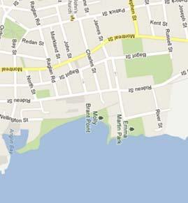
53 6 4 SUBJECT SITE EMMA MARTIN PARK 2 ORCHARD ST. 5 KEY MAP NOT TO SCALE CATARAQUI ST. LEGEND PHASE ONE PROPERTY 4 CATARAQUI ST. 2 CATARAQUI ST. BUILDING PERIMETER 6 CATARAQUI ST. BUILDINGS ON ADJACENT PROPERTIES GRAED AREA SHORELINE 8 CATARAQUI ST. MOLLY BRANT PARK APPROXIMATE LOCATION OF AREA OF POTENTIAL ENVIRONMENTAL CONCERN (APEC) 8 CATARAQUI ST m APPROXIMATE SCALE DRAWING REFERENCE: Base drawing supplied by survey (Leslie M. Higginson Surveying, Ltd., 2013), City of Kingston maps and XCG field notes. NOTE: Location of building, underground utilities, etc. are for reference only and should not be relied upon for detailed design, renovation, or construction purposes. Property boundary and building locations shown may not represent actual surveyed boundaries. APEC1 APEC2 APEC3 APEC4 #30. Importation of Fill Material of Unknown Quality #n/a Hydraulic Elevator (current) #n/a Freight Elevator (historical) #28. Gasoline and Associated Products Storage in Fixed Tanks; #n/a Historical Coal Storage #n/a Historical Boiler Operation SHEET: R FIG04.pdf FILE: R dwg
54 Phase Two Conceptual Site Model, 4 Cataraqui Street, Kingston, Ontario APPENDICES APPENDIX B FIGURES
55
56
57
58
59 Phase Two Conceptual Site Model, 4 Cataraqui Street, Kingston, Ontario APPENDICES APPENDIX C BOREHOLE LOGS
60 CLIENT DRILLING CONTRACTOR DRILLING METHOD ABNA Investments Ltd. PROJECT NUMBER DATE STARTED 31/01/13 SAMPLING METHOD Pionjar GET Drilling Ltd. Split Spoon XCG Consultants Ltd. 6 Cataraqui Street, Suite 105 K7K 1Z7 Telephone: Fax: COMPLETED 31/01/13 LOGGED BY NB CHECKED BY NB PROJECT NAME PROJECT LOCATION GROUND ELEVATION GROUND WATER LEVELS:.04 m AT TIME OF DRILLING --- AT END OF DRILLING --- AFTER DRILLING MONITORING WELL MW1 PAGE 1 OF 1 Phase Two ESA 4 Cataraqui Street, Kingston, ON 2.32 m / Elev m HOLE SIZE DEPTH (m) SAMPLE TYPE NUMBER BLOW COUNTS (N VALUE) ENVIRONMENTAL DATA GRAPHIC LOG RECOVERY (%) MATERIAL DESCRIPTION WELL DIAGRAM 1 PID = 3.9 ppm Concrete floor slab Grey, dry, GRAVEL (fill), no odour, no staining Light brown, moist, SILTY CLAY, trace fine sand, no odour, no staining Flushmount Cover 1 2 PID = 1.6 ppm 0.75 Light brown, moist, SILTY CLAY, no odour, no staining PID = 17.5 ppm Bentonite Seal m bgs 2 4 PID = 19.1 ppm ENVIRONMENTAL BH WOOLEN MILL.GPJ GINT STD CANADA.GDT 01/04/ a PID = 16.1 ppm PID = 17.4 ppm PID = 18.9 ppm PID = 17.3 ppm PID = 16.3 ppm Brown, wet, SILT, trace medium gravel, no odour, no staining Light brown, wet, SILTY CLAY, no odour, no staining Bottom of hole at 4.50 m Sand Pack m bgs 3 cm (1.25in) diametre screen m bgs
61 CLIENT DRILLING CONTRACTOR DRILLING METHOD ABNA Investments Ltd. PROJECT NUMBER DATE STARTED 01/02/13 SAMPLING METHOD Pionjar GET Drilling Ltd. Split Spoon XCG Consultants Ltd. 6 Cataraqui Street, Suite 105 K7K 1Z7 Telephone: Fax: COMPLETED 01/02/13 LOGGED BY NB CHECKED BY NB PROJECT NAME PROJECT LOCATION GROUND ELEVATION GROUND WATER LEVELS:.1 m AT TIME OF DRILLING --- AT END OF DRILLING --- AFTER DRILLING MONITORING WELL MW2 PAGE 1 OF 1 Phase Two ESA 4 Cataraqui Street, Kingston, ON 2.68 m / Elev m HOLE SIZE DEPTH (m) SAMPLE TYPE NUMBER BLOW COUNTS (N VALUE) ENVIRONMENTAL DATA GRAPHIC LOG RECOVERY (%) MATERIAL DESCRIPTION WELL DIAGRAM 1 PID = 14.2 ppm Concrete floor slab Grey, dry, GRAVEL (fill), no odour, no staining Light brown, moist with wet pockets below 1.2 m bgs, SILTY CLAY, no odour, no staining Flushmount Cover 1 2 PID = 18.8 ppm Bentonite Seal m bgs 3 PID = 19.6 ppm 2 4 PID = 17.8 ppm 5 PID = 18.6 ppm ENVIRONMENTAL BH WOOLEN MILL.GPJ GINT STD CANADA.GDT 01/04/ PID = 16.2 ppm PID = 19.5 ppm PID = 16.5 ppm PID = 19.1 ppm PID = 16.8 ppm Grey/brown, moist to wet, SILT, no odour, no staining Bottom of hole at 5.00 m Sand Pack m bgs 3 cm (1.25in) diametre screen 2-5 m bgs
62 XCG Consultants Ltd. 6 Cataraqui Street, Suite 105 K7K 1Z7 Telephone: Fax: MONITORING WELL MW3 PAGE 1 OF 1 CLIENT ABNA Investments Ltd. PROJECT NAME Phase Two ESA PROJECT NUMBER PROJECT LOCATION 4 Cataraqui Street, Kingston, ON DATE STARTED 01/02/13 COMPLETED 01/02/13 GROUND ELEVATION m HOLE SIZE DRILLING CONTRACTOR GET Drilling Ltd. GROUND WATER LEVELS: DRILLING METHOD SAMPLING METHOD Pionjar Split Spoon AT TIME OF DRILLING --- AT END OF DRILLING --- LOGGED BY NB CHECKED BY NB AFTER DRILLING 2.09 m / Elev m DEPTH (m) SAMPLE TYPE NUMBER BLOW COUNTS (N VALUE) ENVIRONMENTAL DATA GRAPHIC LOG RECOVERY (%) MATERIAL DESCRIPTION WELL DIAGRAM GB 1 PID = 22.5 ppm PID = 25.6 ppm Concrete floor slab Dark grey/black, dry, FILL (medium to coarse sand with some fine gravel, trace brick and coal debris), no odour, dark staining FILL as above mixed with SILTY CLAY Brown, moist, SILTY CLAY, no odour, no staining Flushmount Cover 1 2 PID = 24.7 ppm Bentonite Seal m bgs 3 PID = 22.9 ppm 4 PID = 25.6 ppm 2 5 PID = 20 ppm ENVIRONMENTAL BH WOOLEN MILL.GPJ GINT STD CANADA.GDT 01/04/ PID = 19.3 ppm PID = 16.7 ppm PID = 19.4 ppm PID = 19 ppm PID = 21.5 ppm PID = 20.5 ppm 4.90 Bottom of hole at 4.90 m Sand Pack m bgs 3 cm (1.25in) diametre screen m bgs
63 CLIENT ABNA Investments Ltd. PROJECT NUMBER XCG Consultants Ltd. 6 Cataraqui St., Suite 105 Kingston/ON K7K 1Z7 Telephone: Fax: PROJECT NAME PROJECT LOCATION Phase Two ESA MONITORING WELL MW4 PAGE 1 OF 1 4 Cataraqui Street, Kingston, ON DATE STARTED 5/2/13 COMPLETED 5/2/13 DRILLING CONTRACTOR GET Drilling Ltd. DRILLING METHOD Pionjar SAMPLING METHOD Split Spoon LOGGED BY NB CHECKED BY NB GROUND ELEVATION.04 m HOLE SIZE GROUND WATER LEVELS: AT TIME OF DRILLING --- AT END OF DRILLING --- AFTER DRILLING 2.96 m / Elev m DEPTH (m) SAMPLE TYPE NUMBER BLOW COUNTS (N VALUE)/ RQD ENVIRONMENTAL DATA GRAPHIC LOG RECOVERY (%) MATERIAL DESCRIPTION WELL DIAGRAM 1 RQD = % Concrete floor slab Grey, dry, GRAVEL (fill), no odour, no staining Light brown/grey, moist with wet pockets below 1.3 m bgs, SILTY CLAY, no odour, no staining Flushmount Cover 1 2 RQD = % Bentonite Seal m bgs 3 RQD = % 2 4 RQD = % ENVIRONMENTAL BH WOOLEN MILL.GPJ GINT STD CANADA.GDT 5/6/ RQD = % RQD = % RQD = % 4.20 Bottom of hole at 4.20 m Sand Pack m bgs 3 cm (1.25in) diametre screen m bgs