Notice of Availability of an Environmental Assessment Worksheet (EAW) Prairie Feeders, LLC - FP21 Site
|
|
|
- Kory Adam Martin
- 5 years ago
- Views:
Transcription

1 Public comment information EAW public comment period begins: December 3, 2018 EAW public comment period ends: 4:30 p.m. on January 2, 2019 Notice published in the EQB Monitor: December 3, 2018 Permit public comment period begins: December 3, 2018 Permit public comment period ends: January 2, 2019 Notice of Availability of an Environmental Assessment Worksheet (EAW) Prairie Feeders, LLC - FP21 Site Doc Type: Public Notice Facility specific information Facility name and location: Prairie Feeders, LLC FP 21 Site st Street Fountain Township, Pipestone County Pipestone, MN Facility contact: Ian Olson Control Crop Consulting Environmental Services Manager 351 Burlington Circle Marshall, MN MPCA contact information MPCA EAW contact person: Kevin Kain Resource Management and Assistance Division Minnesota Pollution Control Agency 520 Lafayette Road North St. Paul, MN Phone: Fax: kevin.kain@state.mn.us MPCA Permit contact person: Brent Riess Watershed Division Minnesota Pollution Control Agency 504 Fairgrounds Road, Suite 200 Marshall, MN Phone: brent.riess@state.mn.us Admin staff phone: General information The Minnesota Pollution Control Agency (MPCA) is distributing this Environmental Assessment Worksheet (EAW) for a 30-day review and comment period pursuant to the Environmental Quality Board (EQB) rules. The MPCA uses the EAW and any comments received to evaluate the potential for significant environmental effects from the project and decide on the need for an Environmental Impact Statement (EIS). An electronic version of the EAW is available on the MPCA Environmental Review webpage at If you would like a copy of the EAW or NPDES/SDS Permit or have any questions on the EAW NPDES/SDS Permit, contact the appropriate person(s) listed above. Description of proposed project Prairie Feeders, LLC proposes to construct and operate a new 1,440 animal unit (AU) swine finishing feedlot (4,800 swine) consisting of one barn, an animal mortality structure and a livestock water supply well in Section 21, Fountain Prairie Township, Pipestone County Use your preferred relay service Available in alternative formats p-ear2-154a Page 1 of 2
2 Written comments on the EAW must be received by the MPCA EAW contact person within the comment period listed above. For information on how to comment on the (NPDES/SDS Permit, contact the MPCA Permit contact person listed above. NOTE: All comment letters are public documents and will be part of the official public record for this project. Need for an EIS The MPCA Commissioner will make a final decision on the need for an EIS after the end of the comment period Use your preferred relay service Available in alternative formats p-ear2-154a Page 2 of 2
3 Alternative EAW Form for Animal Feedlots ENVIRONMENTAL ASSESSMENT WORKSHEET Note to preparers: This form is authorized for use only for the preparation of Environmental Assessment Worksheets (EAWs) for animal feedlots. Project proposers should consult the guidance Guidelines for Alternative EAW Form for Animal Feedlots (also available at the Minnesota Environmental Quality Board (EQB) website or by calling ) regarding how to supply information needed by the Responsible Government Unit to complete the worksheet form. Note to reviewers: The Environmental Assessment Worksheet (EAW) provides information about a project that may have the potential for significant environmental effects. This EAW was prepared by the Minnesota Pollution Control Agency (MPCA), acting as the Responsible Governmental Unit (RGU), to determine whether an Environmental Impact Statement (EIS) should be prepared. The project proposer supplied reasonably accessible data for, but did not complete the final worksheet. Comments on the EAW must be submitted to the MPCA during the 30-day comment period which begins with notice of the availability of the EAW in the Minnesota Environmental Quality Board (EQB) Monitor. Comments on the EAW should address the accuracy and completeness of information, potential impacts that are reasonably expected to occur that warrant further investigation, and the need for an EIS. A copy of the EAW may be obtained from the MPCA by calling An electronic version of the completed EAW is available at the MPCA website 1. Basic Project Information. A. Feedlot Name: Prairie Feeders, LLC FP21 Site B. Feedlot Proposer: Prairie Feeders, LLC C. RGU: Minnesota Pollution Control Agency Technical Contact Person Ian Olson Contact Person Kevin Kain and Title Environmental Services Manager - Centrol Crop Consulting and Title Project Manager Address 351 Burlington Circle Address 520 Lafayette Road North Marshall, MN St. Paul, Minnesota Phone Phone Fax Fax iolson@control.com Kevin.kain@state.mn.us D. Reason for EAW Preparation: (check one) EIS Scoping Mandatory EAW X Citizen Petition RGU Discretion Proposer Volunteered Printed on recycled paper containing 30% fibers from paper recycled by consumers
4 If EAW or EIS is mandatory, give EQB rule category subpart number and name: Minn. R subp.29a. & subp.29b. E. Project Location: County Pipestone City/Twp Fountain Prairie SE 1/4 SW 1/4 Section 21 Township 108N Range 45W Watershed (name and 4-digit code): Lower Big Sioux River ( ) F. Attach each of the following to the EAW: Attachment A: County map showing the general location of the project Attachment B: U.S. Geological Map Attachment C: Site plan showing all significant project and natural features Attachment D: Neighboring Residences, Water Supply Wells, Sensitive Features, 1-Mile Radius Attachment E: SKIP Attachment F1 F7: Detailed Maps of Manure Application Sites Attachment: G: Cumulative Impact Map Attachment H: Map of manure application sites Attachment I: MN Well Index Map Attachment J: DWSMA Vulnerability Map Attachment K: Groundwater Contamination Susceptibility Map Attachment L: Air Model Area of Interest Map Attachment M: Pipestone County Zoning Districts Map Attachment N: Air Quality Modeling Report Attachment O: Heritage Letter Attachment P: Minnesota Historical Preservation Office Letter Attachment Q: DNR Well Construction Preliminary Assessment G. Project summary of 50 words or less to be published in the EQB Monitor. Prairie Feeders, LLC proposes to construct and operate a new 1,440 animal unit (AU) swine finishing feedlot (4,800 swine) consisting of one barn, an animal mortality structure and a livestock water supply well in Section 21, Fountain Prairie Township, Pipestone County. H. Please check all boxes that apply and fill in requested data: Animal Type Number Proposed Type of Confinement Finishing hogs 4,800 Total confinement with underfloor pit I. Project magnitude data. Total acreage of farm: 3 acres (Project site) 1,543 acres of manure application sites Number of animal units in this project: 1,440 Total animal unit capacity at this location after project construction: 1,440 Acreage required for manure application: 509 Prairie Feeders, LLC FP21 Site Environmental Assessment Fountain Prairie Township, Minnesota 2 Worksheet
5 J. Describe construction methods and timing. Prairie Feeders, LLC (Prairie Feeders) is planning to construct a swine finishing feedlot in Section 21, Fountain Prairie Township, Pipestone County (Project) as shown in Attachments A. The Project will house up to 1,440 animal units (AU) 1 (4,800 finishing swine) and entails construction of the following items (Attachment C): One 122-foot by 336-foot total confinement, power ventilated, swine barn (1,440 AU) with 8-foot deep, poured concrete Liquid Manure Storage Area (LMSA) One 8-foot by 8-foot animal mortality composting building One well for livestock watering utilizing 2.6 million gallons (MG) per year One stormwater basin Prairie Feeders plans to begin construction in 2019, with the installation of stormwater erosion prevention and sediment control best management practices (BMPs), including construction of soil berms to divert surface water runoff from the new barn to existing vegetative buffers (grass strips) for infiltration into the soil. Prairie Feeders will construct a stormwater infiltration/wet sediment basin with a 6-inch drain tile installed beneath the basin. A surface intake on the tile line will handle heavy runoff periods and prevent overtopping of the basin dike. The tile line outlets above ground or connects to existing field tile. Prairie Feeders will place 4-inch high-density polyethylene perimeter drain tile beneath the footings of the LMSA to relieve any seasonal saturation and limit any hydrostatic pressure on the LMSA walls. This will also help dewater the Project excavation area, if necessary, due to the presence of perched groundwater or following precipitation events. The perimeter drain tile will discharge to existing agricultural drain tile and move off site. An inspection port allows Prairie Feeders to observe that the tile is operational and identify any seepage from the LSMA if a leak were to occur. Prairie Feeders will install the LMSA, perimeter drain tile, and expanded utilities at the same time. After placement of the reinforced steel and concrete forms, Prairie Feeders will construct the LMSA floors. Finally, after the design engineer has approved the wall and column construction, Prairie Feeders will install the precast beams and slats. Prairie Feeders expects to complete construction in the summer of 2019; actual construction dates are dependent on completion of the environmental review process, issuance of the Minnesota Department of Natural Resources (MDNR) Water Appropriation Permit, and issuance of the Feedlot Permit 2. K. Past and future stages. Is this project an expansion or addition to an existing feedlot? Yes No Are future expansions of this feedlot planned or likely? Yes No If either question is answered yes, briefly describe the existing feedlot (species, number of animals and animal units, and type of operation) and any past environmental review or the anticipated expansion. 1 An animal unit or AU is a unit of measure developed to compare the differences in the amount of manure produced by livestock species. The AU is standardized to the amount of manure produced on a regular basis by a slaughter steer or heifer, which also correlates to 1,000 pounds of body weight. The AU is used for administrative purposes by various governmental entities for permitting and recordkeeping. 2 The Feedlot NPDES Permit is required for a Concentrated Animal Feeding Operation capable of holding 1,000 or more AUs. Prairie Feeders, LLC FP21 Site Environmental Assessment Fountain Prairie Township, Minnesota 3 Worksheet
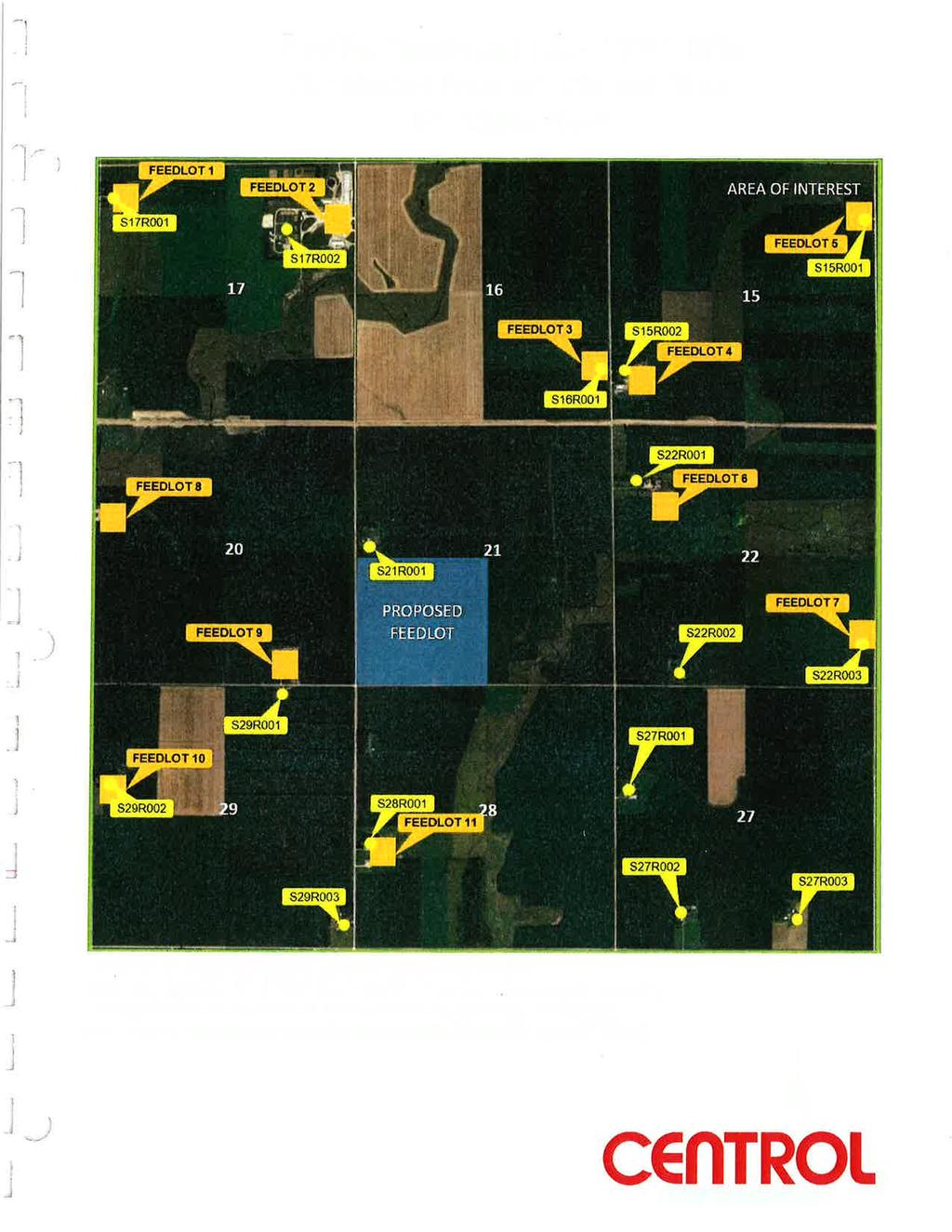
6 2. Land uses and noteworthy resources in proximity to the site. A. Adjacent land uses. Describe the uses of adjacent lands and give the distances and directions to nearby residences, schools, daycare facilities, senior citizen housing, places of worship, and other places accessible to the public (including roads) within one mile of the feedlot and within or adjacent to the boundaries of the manure application sites. Project Site Project site is in Pipestone County on land zoned for agricultural use and is rural in nature. The closest incorporated town, Holland, Minnesota, is approximately 4 miles to the south/southeast. There are six residence/building sites and six registered feedlots located within 1mile, with the nearest occupied residence approximately 3,200 feet to the west (Attachment D). The Project site is in the Lower Big Sioux Watershed (HUC ). There are no noted lakes or protected water wetlands within a 1-mile radius of the Project. The closest identified water source is an unnamed stream ( ) located approximately 840 feet to the east of the site. The north branch of Pipestone Creek is the closest named watercourse located approximately 2.1 miles south/ southeast. The nearest public roads to the Project site include: 201 st Street to the south Pipestone County Road 78 (100 th Avenue) to the west 110 th Avenue to the east Pipestone County Road 10 (211 th Street) to the north There are no identified or registered schools, daycare facilities, senior citizen housing, places of worship or other places accessible to the public within 1-mile of the Project. Manure Application Sites: Site 1 and 2. Bare 80 and West Qtr 21: Total of acres in SW1/4 of Section 21, Fountain Township, Pipestone County. Primary soil type is J70A. There is an unnamed watercourse approximately 520 feet to the east of the eastern site boundary. There is one residence directly adjacent to the north of the site. The site is within the Lincoln-Pipestone Rural Water Supply Holland Drinking Water Supply Management Area (DWSMA). Attachment F-1 Site 3. Burzlaff Qtr: acres in the SE1/4 of Section 20, Fountain Township, Pipestone County. Primary Soil Type is J74A. There is one residence directly adjacent (within) the south site boarder. There is one residence south across the road from the site. The site is within the Lincoln-Pipestone Rural Water Supply Holland DWSMA. Attachment F-2 Site 4. Van Beek N&S: acres in the SE1/4 of Section 22, Fountain Township, Pipestone County. Primary Soil is J90B. There is one residence and registered feedlot adjacent to the site along the eastern boundary. The next nearest residence/feedlot is approximately 1/8 mile to the west of the western site boundary. The site also has an unnamed watercourse approximately 250 feet to the north. There is a natural vegetative buffer that separates the site boundary and the watercourse. The site is within the Lincoln-Pipestone Rural Water Supply Holland DWSMA. Attachment F-3 Site 5. Bill and Lenas Church NE: acres in the NE1/4 of Section 27, Fountain Township, Pipestone County. The primary soil type is J90. The nearest residence is across Pipestone County Road 79 Prairie Feeders, LLC FP21 Site Environmental Assessment Fountain Prairie Township, Minnesota 4 Worksheet
7 approximately 100 feet to the east of the site. There is one unnamed U.S. Geological Survey (USGS) intermittent stream that runs diagonally from northeast to southwest through the site. This site is adjacent to the manure application site listed as Bill and Lenas Church southeast. The site is within the Lincoln-Pipestone Rural Water Supply Holland DWSMA. Attachment F-4 Site 6. Bill and Lenas Church SE: acres in the SE1/4 of Section 27, Fountain Township, Pipestone County. The primary soil type is J90B. The closest residence is adjacent to the site in the southwest quadrant. The next closest residence is approximately 1/4 mile to the west. There are two identified USGS intermittent streams that run diagonally from northeast to southwest through the site. This site is adjacent to the manure application site listed as Bill and Lenas Church northeast. The site is within the Lincoln-Pipestone Rural Water Supply Holland DWSMA. Attachment F-4 Site 7. Van Beek Qtr SW: acres in the SW1/4 of Section 27, Fountain Township, Pipestone County. The primary soil type is J90B. The closest residence is adjacent to the south site boundary. The next closest residence is approximately ¼ mile to the east. There are two identified USGS intermittent streams that run diagonally from northeast to southwest through the site. This site is adjacent to the manure application site listed as Bill and Lenas Church southeast. The site is within the Lincoln-Pipestone Rural Water Supply Holland DWSMA. Attachment F-4 Site 8. Griebel Qtr: acres in the SW1/4 of Section 26, Fountain Township, Pipestone County. The primary soil type is J90B. The closest residences/feedlots are approximately 670 feet to the north, 1,580 feet to the east, 1,000 feet to the south, and 1,700 feet to the west of the site. The site has three identified USGS intermittent streams and one shaped grassed waterway present. The north branch of Pipestone Creek is approximately 1,500 feet to the southeast across Pipestone County Road 80 (191 st Street). The site is within the Lincoln-Pipestone Rural Water Supply-Holland DWSMA. Attachment F-5 Site 9 and 10. Al s NW-W and Al s NW-E: acres in the NW1/4 of Section 34, Fountain Township, Pipestone County. Primary soil type J90B (Al s NW-E) and J71A (Al s NW-W). The closest residence and/or feedlot is adjacent to the site in the southwest quadrant of the site boundary. The two sites are split by a USGS intermittent stream running north to south. Al s NW-E also has an identified USGS intermittent stream bisecting it east to west. There is one noted tile intake along the west side of Al s NW-W. The closest watercourse is the north branch of Pipestone Creek approximately 1,800 feet south/southeast of Al s NW-E. The sites are within the Lincoln-Pipestone Rural Water Supply-Holland DWSMA. Attachment F-6 Site 11. Al s NE-N: acres in the NE1/4 of Section 34, Fountain Township, Pipestone County. Primary soil type is J90B. The closest residence and feedlot is adjacent to the site boundary in the southeast corner. The adjacent Project has a known private well that is approximately 300 feet from where any manure is applied. The site also has an identified USGS intermittent stream that flows through it from the northeast to the southwest. The north branch of Pipestone Creek is approximately 1,900 feet south of the site. The site is within the Lincoln-Pipestone Rural Water Supply-Holland DWSMA. Attachment F-6 Site 12 and 13. Al s NE-S and Al s NE 16 Across from Grandpas: Total of acres in the S1/2 of the NE1/4 and the N1/2 of the SE1/4 of Section 34, Fountain Township, Pipestone County. Primary soil is J90B (Al s NE-S) and J85A (Al s NE Across from Grandpas). The closest residence/feedlot is adjacent to Al s NE-S in the northeast corner of the site. The same residence is approximately 1,100 feet north of Al s NE 16 Across from Grandpas. There is a residence/feedlot directly to the east of the two sites across County Road 79. The north branch of Pipestone Creek is adjacent to the south boarder of both farms. There is a natural vegetative buffer that is a minimum feet wide in most areas between the ditch and the manure application site. There is also a channelized USGS intermittent stream that divides the two sites running from the northeast to the southwest. Both sites are within the Lincoln-Pipestone Rural Water Supply Holland DWSMA. Attachment F-6 Prairie Feeders, LLC FP21 Site Environmental Assessment Fountain Prairie Township, Minnesota 5 Worksheet
8 Site 14. Dewitt: acres in the SW1/4 of Section 10, Fountain Township, Pipestone County. Primary soil type: J71A. This site is across the road to the east of an existing livestock facility. There are also existing livestock facilities/residences approximately 2,640 feet to the east and to the north. The closest watercourse is an unnamed stream 830 feet to the SE across 221 st Street. Attachment F-7 B. Compatibility with plans and land use regulations. Is the project subject to any of the following adopted plans or ordinances? Check all that apply: local comprehensive plan land use plan or ordinance shoreland zoning ordinance flood plain ordinance wild or scenic river land use district ordinance local wellhead protection plan Is there anything about the feedlot that is not consistent with any provision of any ordinance or plan checked? Yes No. If yes, describe the inconsistency and how it will be resolved. Are there any lands in proximity to the feedlot that are officially planned for or zoned for future uses that might be incompatible with a feedlot (such as residential development)? Yes No If yes, describe the potentially affected use and its location relative to the feedlot, its anticipated development schedule, and any plans to avoid or minimize potential conflicts with the feedlot. C. Nearby resources. Are any of the following resources on or in proximity to the feedlot, manure storage areas, or within or adjacent to the boundaries of the manure application sites? Drinking Water Supply Management Areas designated by the Minnesota Department of Health? Yes No Public water supply wells (within two miles)? Yes No Archaeological, historical or architectural resources? Yes No Designated public parks, recreation areas or trails? Yes No Lakes or Wildlife Management Areas? Yes No State-listed (endangered, threatened or special concern) species, rare plant communities or other sensitive ecological resources such as native prairie habitat, colonial waterbird nesting colonies or regionally rare plant communities? Yes No Scenic views and vistas? Yes No Other unique resources? Yes No If yes, describe the resource and identify any project-related impacts on the resource. Describe any measures to minimize or avoid adverse impacts. Drinking Water Supply Management Areas (Attachment J): The Project site is inside the Lincoln-Pipestone Rural Water Supply-Holland DWSMA, which is identified as vulnerable for contamination by the Minnesota Department of Health (MDH) ( The Project itself is a total confinement facility with a LMSA designed to prevent any leaking of manure that would potentially Prairie Feeders, LLC FP21 Site Environmental Assessment Fountain Prairie Township, Minnesota 6 Worksheet
9 leach into the surrounding groundwater supply. The engineered plans include a Stormwater Pollution Prevention Plan (SWPPP). This plan provides detailed guidelines, BMPs and mitigation strategies for handling surface water flow off the impervious surfaces before, during, and after construction. The application sites (except Manure Application Site 14 - Dewitt farm) are also within the Lincoln- Pipestone Rural Water Supply-Holland DWSMA. Prairie Feeders will mitigate potential impacts to drinking water by following a MPCA-approved Manure Management Plan (MMP) and submitting an annual report to the MPCA on manure production, land application, and any discharges. The approved MMP is an integral and enforceable part of the Feedlot Permit. State-listed (endangered, threatened or special concern) species, rare plant communities or other sensitive ecological resources (Attachment P): The MDNR reviewed its Minnesota Natural Heritage database to determine if any rare plant or animal species or other significant natural features are known to occur within an approximate 1-mile radius of the Project or manure application sites. The MDNR review letter indicates that there is the potential presence of calcareous fens and critical habitat for the Topeka Shiner documented in the vicinity of the Project site. Calcareous Fen The calcareous fens are identified as wetlands and subject to the Wetland Conservation Act, which requires no manipulation or mechanical tillage or land application of manure occur and application setback requirements for manure will follow any non-cropped wetland. Project site The area of construction for the Project should have no direct impact on any calcareous fens as none have been identified within the footprint of the Project site. Manure application acres Manure application sites are existing fields that have been farmed for decades with no known impacts to the calcareous fens that may be located near the fields. Water appropriation The biggest potential for impact to the calcareous fens would be from a water supply well. A preliminary MDNR Well Construction and Water Appropriation permit has been filed with the MDNR (Attachment Q). The finding of that application provides preliminary approval to construct a well; however, it does also note that the well is in an area of high use, near a stream known to be inhabited by the Topeka Shiner, within the DWSMA for Lincoln Pipestone Rural Water, and within 5 miles of the Aetna 29 Calcareous Fen, a state protected feature with zero allowable impact. Topeka Shiner The MDNR review identified Topeka Shiners, a federally-listed endangered and state-listed special concern fish species, in the vicinity of the Project site. The Project site is less than 1,000 feet from an unnamed stream (PWI ID#59047) that has been federally designated as a critical habitat for the Topeka Shiner. A number of manure application sites are near streams that have been federally designated as a critical habitat for the Topeka Shiner. Prairie Feeders, LLC FP21 Site Environmental Assessment Fountain Prairie Township, Minnesota 7 Worksheet
10 The greatest potential for impact to critical habitat streams would be actions that alter stream hydrology and/or decrease water quality. Prairie Feeders anticipates that no stream hydrology manipulation is expected, and all construction activities will be completed outside of the area that would result in altered streambank or hydrologic flow. Prairie Feeders will follow all required manure application setbacks and follow land application BMPs to minimize any potential impact to water quality resulting from nutrient runoff or leaching. At this point, Prairie Feeders has not contacted the U.S. Fish and Wildlife Services but will if further investigation is necessary. 3. Geologic and soil conditions. A. Approximate depth (in feet) to: Feedlot Manure Storage Area Manure Application Sites Ground Water (minimum) 0.5 Feet 0.5 Feet 0.5 Feet (average) >6.5 Feet >6.5 Feet >6.5 Feet Bedrock (minimum) >6.5 Feet >6.5 Feet >6.5 Feet (average) >6.5 Feet >6.5 Feet >6.5 Feet B. NRCS Soil Feedlot Manure Storage Area Manure Application Sites Classifications (if known) J74A-Silty Loam J74B- Silty Loam J74A- Silty Loam J74B- Silty Loam J90B- Silty Loam J70A- Silty Loam J74A- Silty Loam J85A- Silty Loam J71A- Silty Loam C. Indicate with a yes or no whether any of the following geologic site hazards to groundwater are present at the feedlot, manure storage area, or manure application sites. Karst features (sinkhole, cave, resurgent spring, disappearing spring, karst window, blind valley, or dry valley) Feedlot Manure Storage Area Manure Application Sites No No No Exposed bedrock No No No Soils developed in bedrock (as No No No shown on soils maps) For items answered yes (in C), describe the features, show them on a map, and discuss design and mitigation measures to avoid or minimize potential impacts. 4. Water Use, Tiling and Drainage, and Physical Alterations. A. Will the project involve installation or abandonment of any water wells, appropriation of any ground or surface water (including dewatering), or connection to any public water supply? Yes No If yes, as applicable, give location and purpose of any new wells; the source, duration, quantity and purpose of any appropriations or public supply connections; and unique well numbers and the Department of Natural Resources (DNR) appropriation permit numbers, if available. Identify any existing and new wells on the site map. If there are no wells known on-site, explain methodology used to determine that none are present. Prairie Feeders, LLC FP21 Site Environmental Assessment Fountain Prairie Township, Minnesota 8 Worksheet
11 Prairie Feeders will install a new water supply well at the Project site for livestock water needs and expects to pump 2.6 MG from the well per year for livestock use. The well location is east of the site in the southeast corner of the SE1/4 of the SW1/4 Section 21, Fountain Township as shown on Attachment C. Prairie Feeders applied to MDNR for a preliminary well construction assessment. The findings of the Well Construction Preliminary Assessment provided a preliminary approval to construct. The assessment addressed the potential concerns regarding the wells location in an area of high water use, proximity to streams known to inhabit the Topeka Shiner, location within a DWSMA, and distance within 5 miles of the Aetna 29 Calcareous Fen. (Attachment Q) Prairie Feeders must obtain and maintain all appropriate MDNR well appropriation permits if approved for construction. Prairie Feeders will meet all required separation distances from the Project site and LMSA and will follow all MDH requirements for new well construction. The purpose of the MDNR permit program is to ensure water resources are managed so that adequate supply is provided to long-range seasonal requirements for domestic, agricultural, fish and wildlife, recreational, power, navigational, and quality control. The permit program balances competing management objectives, including both the development and protection of water resources. Minn. Stat. 103G.261 establishes domestic water use as the highest priority of the state s water when supplies are limited. If a well interference arises, the MDNR has a standard procedure for investigating the matter. If a commercial operator is found to be causing the problem, the operator must correct it. The feedlot owner will be required to assess the potential impacts during the water appropriation permit review process. A preliminary well construction permit has been applied for and has been awarded (Attachment Q). A full permit will be applied for upon approval of construction. B. Will the project involve installation of drain tiling, tile inlets or outlets? Yes No If yes, describe. Prairie Feeders will install a 4-inch diameter high-density polyethylene perimeter drain tile around the base of the LMSA to control hydrostatic pressure on the outside of LMSA walls caused by fluctuations in seasonal saturation. Inspection ports connected to the perimeter tiles will allow Prairie Feeders to observe if the tiles are operational, and may help to identify seepage from the pits if a leak were to occur. The drain tile will connect to existing agricultural drain tiles at the Feedlot. Prairie Feeders will follow the Operation and Maintenance Plan submitted as part of its Feedlot Permit application. The plan is integral to, and enforceable through, the Feedlot Permit and must meet the requirements of Minn. R The plan must include perimeter tile-specific requirements for Prairie Feeders to follow including: Prairie Feeders must conduct monthly inspections of the perimeter drain tile for water flow and signs of discoloration or odor. Prairie Feeders must maintain records of all inspections as part of the operation and maintenance for the LMSAs. C. Will the project involve the physical or hydrologic alteration dredging, filling, stream diversion, outfall structure, diking, and impoundment of any surface waters such as a lake, pond, wetland, stream or drainage ditch? Yes No Prairie Feeders, LLC FP21 Site Environmental Assessment Fountain Prairie Township, Minnesota 9 Worksheet
12 If yes, identify water resource affected and give the DNR Protected Waters Inventory number(s) if the water resources affected are on the PWI. Describe mitigation measures to avoid or minimize impacts. 5. Manure management. A. Check the box or boxes below which best describe the manure management system for this feedlot. Stockpiling for land application Containment storage under barns for land application Containment storage outside of barns for land application Dry litter pack on barn floors for eventual land application Composting system Treatment of manure to remove solids and/or to recover energy Other (please describe) B. Manure collection, handling, and storage. Quantities of manure generated: total 1,668,494 Frequency and duration of manure removal: number of days per cycle Total days per year once per year Give a brief description of how manures will be collected, handled (including methods of removal), and stored at this feedlot: Swine manure and wastewater generated by the Project will drop through slatted floors in the barn into the LMSA. The LMSA will have a capacity of 1.94 million gallons, which represents manure storage capacity in excess of 1 year. In the fall of the year, the swine manure in the LMSA will be agitated and pumped out by a portable chopper pump. Manure application is conducted utilizing equipment that injects the manure below the soil surface (4-6 inches) immediately upon land application. All swine manure will be applied by a licensed Commercial Animal Waste Technician (CAWT). C. Manure utilization. Physical state of manure to be applied: liquid solid other - describe: D. Manure application. 1. Describe application technology, technique, frequency, time of year and locations. Manure will be applied by a CAWT applicator using towable liquid tankers as the primary application technique. Although not guaranteed, it is assumed that in most cases the application equipment will be equipped with flow meters, application monitors, and GPS guidance. All manure is planned and anticipated to be applied in the fall of the year as late as possible to ensure soil temperatures are below 50 degrees. If needed, due to weather limitation or other unforeseen circumstances in the fall, some manure may be pumped in the spring after snow melt and peak snow melt flow periods and before planting work. All manure will be applied to pre-approved Prairie Feeders, LLC FP21 Site Environmental Assessment Fountain Prairie Township, Minnesota 10 Worksheet
13 manure application sites following all sensitive feature setback requirements for injected manure, or if manure is transferred or sold, it will be done in accordance with the MPCA guidelines for manure transfer of ownership. 2. Describe the agronomic rates of application (per acre) to be used and whether the rates are based on nitrogen or phosphorus. Will there be a nutrient management plan? Yes No Prairie Feeders submitted a MMP with the Feedlot Permit application for the site. After MPCA staff reviews and approves the MMP, it becomes an integral and enforceable part of the Feedlot Permit. Minn. R Land Application of Manure, outlines the requirements for appropriate manure testing, land application of manure, requirements, restrictions, prohibitions, recordkeeping as well as what must be included in an MMP. The MMP requires the licensed CAWT to ensure the manure application occurs at agronomic rates based on: the previous crop harvested, the available nutrients, and the crop to be grown. The MMP also specifies the requirements to change from nitrogen to phosphorus-based application rates, if needed in the future. Based on current soil test values, all sites for land application have no phosphorous management requirement more than 300 feet away from any sensitive features and will follow a nitrogen based application plan. All sites with an average soil test greater than 17 parts per million (ppm) Olsen, will need to prevent long term phosphorous build up within 300 feet of any sensitive feature. In this case, a 6-year soil phosphorus management plan will be used to determine application rate. Based on the phosphorous management plan, long-term build-up should not occur with every other year application of manure in a corn and soybean rotation even if nitrogen application rates are applied. In a corn on corn rotational situation, lower application rates may be necessary based on estimated crop removal of phosphorous. 3. Discuss the capacity of the sites to handle the volume and composition of manure. Identify any improvements necessary. Prairie Feeders estimates that the Project will generate approximately 1.67 million gallons of manure and process wastewater per year from the 4,880 head of swine. The LMSA will have a total storage capacity of approximately 1.94 million gallons. Prairie Feeders has 14 manure application sites available totaling 1,543 acres for the Project (Attachment H). All acres are available for manure application based on the current soil test values and the operations plan to directly inject and/or incorporate all manure within 24 hours. Prairie Feeders anticipates that approximately 509 acres are needed annually for land application based on anticipated manure test values, crop rotation, and manure handling and application methods. Based on the MMP, this means that in an approximately 50/50 corn, soybean crop rotation a minimum of 1,020 acres would be needed for 2 years worth of manure application. Currently, the Project has access to 33% more acres then they are likely to need or utilize. 4. Describe any required setbacks for land application systems. The CAWT must comply with the most stringent of the following applicable requirements: Prairie Feeders, LLC FP21 Site Environmental Assessment Fountain Prairie Township, Minnesota 11 Worksheet
14 Minnesota Administrative Rules regarding land application of manure (see table below); and Pipestone County 25 foot setback requirement from all surface water features and tile intakes. Minn. R Land Application of Manure Setbacks (feet) Feature Minimum manure application setbacks (in feet) near sensitive features Winter frozen or snowcovered soils Winter Frozen or snowcovered soils Non-Winter With immediate incorporation (<24 hours) With phosphorus management Without phosphorus management Non-Winter Not incorporated within 24 hours With vegetated buffer Inadequate vegetated buffer Lake, stream Intermittent stream 1, DNR protected wetland 2, drainage ditch without b Open tile intake Water well, mine, sinkhole or quarry Intermittent streams and ditches pertain to those identified on USGS quadrangle maps, excluding drainage ditches with berms that protect from runoff into the ditch and segments of intermittent streams, which are grassed waterways. USGS quadrangle maps can be found at County Soil and Water Conservation District Offices, or can be viewed on the internet at: 2 Wetland setbacks pertain to all protected wetlands identified on DNR protected waters and wetlands maps (these maps are often in County Soil and Water Conservation District offices and typically include all wetlands over ten acres). E. Other methods of manure utilization. If the project will utilize manure other than by land application, please describe the methods. None 6. Air/odor emissions. A. Identify the major sources of air or odor emissions from this feedlot. The building s ventilation and the surfaces of the barn that come into contact with animals and manure, especially floors, are sources of odor. The animals themselves are also sources of odor. The LMSA and the manure application sites are also significant sources of odor. Dust generated by truck traffic around the Project site can also contribute as a carrier of odor. B. Describe any feedlot design features or air or odor emission mitigation measures to be implemented to avoid or minimize potential adverse impacts and discuss their anticipated effectiveness. Prairie Feeders will implement the following design and operation measures to reduce odors. Project design and operation measures to reduce odor include: The feedlot will be a total confinement operation, with a poured concrete LMSA. This design minimizes the surface area of manure exposed to the air. 3 Prairie Feeders, LLC FP21 Site Environmental Assessment Fountain Prairie Township, Minnesota 12 Worksheet
15 Prairie Feeders will maintain clean, dry floors, eliminate manure buildup, and clean up any spilled feed. Prairie Feeders will thoroughly wash and disinfect interior surfaces at the end of each cycle. Prairie Feeders will give special attention to cleaning the ventilation fans and pit exhaust fans. Prairie Feeders will only agitate stored manure immediately before the manure is removed for land application. If needed, a pit additive may be used to breakdown solids in the LMSA and reduce odors. Additional practices including but not limited to: tree planting to disperse air, good neighbor relations plan, etc. may be implemented in the future if deemed necessary. Manure land application measures to reduce odor include: The CAWT will land apply manure by direct injection as soon as site conditions permit to prevent contact with the atmosphere. The CAWT will observe all required setback requirements from nearby residences for all manure applications. The CAWT will respond to complaints by consulting with the MPCA/County Feedlot Officer to identify possible changes to reduce odors. The CAWT will evaluate weather conditions, primarily wind speed/direction and humidity, before manure is land applied to insure minimal impacts on neighbors and the public. The CAWT will use BMPs such as properly operating manure equipment to reduce/eliminate spillage. Prairie Feeders will consult with the MPCA feedlot staff or the Pipestone County Feedlot Officer to identify any changes needed to reduce odors in the event of complaints. C. Answer this item only if no feedlot design features or mitigations were in item 6.B. Provide a summary of the results of an air emissions modeling study designed to compare predicted emissions at the property boundaries with state standards, health risk values, or odor threshold concentrations. The modeling must incorporate an appropriate background concentration for hydrogen sulfide to account for potential cumulative air quality impacts. Prairie Feeders conducted air dispersion modeling to predict how the Project s emissions (including the Existing Feedlot and 16 neighboring feedlots) of hydrogen sulfide, ammonia, and odors would impact air quality at the Project s property lines and at the nearest residences to the Project site. The modeling was done using the American Meteorological Society/Environmental Protection Agency Regulatory Model (AERMOD). The modeling results are contained within the report attached as Attachment N of the EAW. The following is a summary of the conclusions of the air modeling report. Hydrogen sulfide (H 2S) Minnesota Ambient Air Quality Standard (MAAQS) AERMOD predicted that the Project will not result in an exceedance of the 30 parts per billion (ppb) H 2S MAAQS. The third exceedance of the MAAQS standard within any 5-day period is a violation. Modeled compliance is demonstrated when the high-third-high (H3H) H 2S predicted concentration from the Project, when added to the existing background ambient air concentration for H 2S (at each property-line receptor) is less than 30 ppb. AERMOD predicted that the Project emissions alone would result in a maximum H3H property-line H 2S concentration of 9.7 ppb. The ambient air concentration for H 2S in the area of the Project is estimated to be 17 ppb. The total (Project emissions plus existing background) H3H H 2S concentration in the air is predicted to be 26.7 ppb at the Project s property lines. Prairie Feeders, LLC FP21 Site Environmental Assessment Fountain Prairie Township, Minnesota 13 Worksheet
16 Sub-chronic Inhalation Health Risk Value (ihrv) AERMOD predicted that the Project will not result in an exceedance of the 10 micrograms per cubic meter (µg/m 3 ) subchronic (13-week time averaged) H 2S ihrv at the nearest residences to the Project. An ihrv is the concentration of a chemical (or a defined mixture of chemicals) that is likely to pose little or no risk to human health. AERMOD predicted that the Project emissions alone would result in a maximum monthly H 2S concentration at the neighboring residences of 2.6 micrograms per cubic meter (µg/m 3 ). The background ambient air concentration for H 2S in the area of the Project is estimated to be 1.0 µg/m 3. The total (Project emissions plus existing background) H 2S concentration in the air is predicted to be 3.6 µg/m 3. Note that while the ihrv is for a 13-week period, AERMOD is not capable of averaging concentrations for this time. Instead, AERMOD uses a monthly averaging period, which produces a more conservative or protective prediction. Ammonia (NH 3) Acute ihrv AERMOD predicted that the Project will not result in an exceedance of the 3,200 µg/m 3 acute (1-hour time averaged) NH 3 ihrv at the nearest residences to the Project. AERMOD predicted that the Project emissions alone would result in a maximum hourly property-line concentration of NH 3 of 220 µg/m 3. The background ambient air concentration for NH 3 in the area of the Project is estimated to be 148 µg/m 3. The total (Project emissions plus existing background) NH 3 concentration in the air is predicted to be 368 µg/m 3. Chronic ihrv AERMOD predicted that the Project will not result in an exceedance of the 80 µg/m 3 chronic (1-year time averaged) NH 3 ihrv at the nearest residences to the Project. AERMOD predicted that the Project emissions alone would result in a maximum 1-year time-averaged NH 3 concentration of 28.4 µg/m 3. The background ambient air concentration for NH 3 in the Project area is estimated to be 5.7 µg/m 3. The total (Project emissions plus existing background) maximum NH 3 concentration in the air is predicted to be 34.1 µg/m 3. Odor At Project Property Line AERMOD predicted that the Project will result in a maximum odor intensity of 28 odor units per cubic meter (OU/m 3 ) at the Project s north property line. This predicted odor intensity is considered Very Faint. At Nearest Residence Without a Feedlot AERMOD predicted that the Project would result in a maximum odor intensity of 6 OU/m 3 at a nearby residence. This predicted odor intensity is considered to be No odor. At Nearest Residence With a Feedlot AERMOD predicted that the Project would result in a maximum odor intensity of 56 OU/m 3 at a nearby residence. This predicted odor intensity is considered to be Faint odor. Maximum Property Boundary AERMOD Air Quality Modeling Results Modeled value Background value Modeled plus Background value Threshold Percent of Threshold 1-hour H2S H3H 9.7 ppb 17 ppb ppb 30 ppb 89.0% 1-hour NH3 220 µg/m µg/m µg/m 3 3,200 µg/m % Maximum Hourly Odor Intensity 28 OU/m 3 NA 28 OU/m 3 72 OU/m 3 (Faint) 38.9% Prairie Feeders, LLC FP21 Site Environmental Assessment Fountain Prairie Township, Minnesota 14 Worksheet
17 Maximum Nearest Neighbor AERMOD Air Quality Modeling Results Modeled value Background value Modeled plus Background value Threshold Percent of Threshold 13-week H2S 2.6 µg/m µg/m µg/m µg/m 3 36% Annual NH µg/m µg/m µg/m µg/m 3 38% Maximum Hourly 6 OU/m 3 NA 6 OU/m 3 25 OU/m 3 24% Odor Intensity Without Feedlot (No Odor) Maximum Hourly Odor Intensity Nearest Neighbor with Feedlot 56 OU/m 3 NA 56 OU/m 3 72 OU/m 3 (Faint) 78% Thus, the AERMOD modeling results for the Project suggest compliance with the hydrogen sulfide air quality standard, no exceedances of the subchronic hydrogen sulfide ihrv, no exceedances of the acute ammonia ihrv, and no exceedances of chronic ammonia ihrv. C. Describe any plans to notify neighbors of operational events (such as manure storage agitation and pumpout) that may result in higher-than-usual levels of air or odor emissions. Prairie Feeders does not plan to notify neighbors before operational events such as manure storage, agitation, pump out, or application. Prairie Feeders plans to avoid manure handling during planned social events and/or holidays. Prairie Feeders will work with county and state officials to find a resolution if there are complaints. Prairie Feeders will implement the air emission plan included in the Feedlot Permit application in the event that an odor event occurs. The air emission plan is an enforceable provision of the Feedlot Permit. E. Noise and dust. Describe sources, characteristics, duration, quantities or intensity and any measures to mitigate adverse impacts. Construction of the Project will involve extensive dirt moving work. If dust becomes a significant issue, Prairie Feeders will use a dust abatement, such as water, to help control it. During Project operations, the major causes of dust would be truck traffic using the gravel entrance road and exhaust fans. If dust becomes an issue, Prairie Feeders will use a dust abatement method, such as water spray, to help control it. The largest source of noise at this Project will be from exhaust fans. The nearest residence to the Project site is over 3,000 feet to the west. The biggest mitigation factor in noise and dust abatement will be the physical distance between the Project site and the residences. No additional plans are currently in place for noise or dust abatement. 7. Dead Animal Disposal. Describe the quantities of dead animals anticipated, the method for storing and disposing of carcasses, and frequency of disposal. Prairie Feeders plans to construct an 8-foot x 8-foot animal mortality structure at the Project site. The structure will be constructed of concrete or polyvinyl and will serve as a holding area for dead animals Prairie Feeders, LLC FP21 Site Environmental Assessment Fountain Prairie Township, Minnesota 15 Worksheet
18 prior to pick up by a rendering service. The structure will be inaccessible to any scavengers and will keep dead animal out of a visual line of site for neighbors or vehicles that drive by. Prairie Feeders plans to do daily inspection for animal mortalities and transfer the dead animals to the mortality collection structure immediately. Prairie Feeders will follow the Minnesota Board of Animal Health requirements for storage, disposal and pick up of any dead animals. Prairie Feeders predicts that the annual mortality rate will be approximately 72 swine per year from the Project. 8. Surface Water Runoff. Compare the quantity and quality of site runoff before and after the project. Describe permanent controls to manage or treat runoff. Project: Prairie Feeders construction of roofed buildings and driveway will result in an increase in surface water runoff at the Project site. The Construction Stormwater (CSW) General Permit requires projects that create 1 acre or more of new impervious surface must retain and permanently treat the water quantity volume of 1-inch of runoff by infiltration, or other volume reduction practices, and not discharge to surface waters. The proposed barn is total confinement and will prevent runoff from contact with livestock or manure. Prairie Feeders construction of the proposed barn and additional gravel pad and driveway will result in a total impervious area of 3 acres. Due to the increase in new impervious surface area, to comply with the CSW General Permit for volume reduction, Prairie Feeders will construct a permanent 78 x 112-foot stormwater basin that will control the velocity of the runoff where the sediment contained in the runoff will settle before the treated stormwater leaves the site. Prairie Feeders has prepared a SWPPP for the Project that meets the requirements of the CSW General Permit for erosion prevention and sediment control during feedlot construction. Manure Application Sites: All manure generated by the Project will be land applied, at agronomic rates, at the manure application sites (Attachment H) by a CAWT. Prairie Feeders or the manure recipients, as applicable, will determine the agronomic rate based on the type of crop grown, the soil type, and the soil fertility. The CAWT will land apply manure in the fall of the year. The CAWT will apply the manure directly into the soil via knife or sweep injection. The CAWT must adhere to applicable manure application setbacks as outlined in Item 5 of the EAW. All the manure application sites are within the Lower Big Sioux River watershed. Previous landowners have farmed land in the watersheds for several decades. Prairie Feeders expects the stormwater runoff characteristics from the Project manure application areas to remain the same, and under certain circumstances, improve because of the land application activities regulated under the Feedlot Permit. The improvements occur through developing better soil tilth from organic fertilizer and the uniform practice of incorporating manure over the acres identified in the MMP. 9. Traffic and Public Infrastructure Impacts. A. Estimate the number of heavy truck trips generated per week and describes their routing over local roads. Describe any road improvements to be made. Prairie Feeders, LLC FP21 Site Environmental Assessment Fountain Prairie Township, Minnesota 16 Worksheet
19 The Project will result in additional traffic from the following feedlot activities: Feedlot Management - A single passenger vehicle will visit the Project site daily. Swine Feeding - A feed truck will visit the Project site once per week. Swine Re-stocking - Approximately 6 semi-tractors with trailers will bring swine to the Project site three times per year. Each re-stocking will take approximately 1 day to complete. Swine Load-out - Approximately 26 semi-tractors with trailers will be used to load the finished swine from the barns and take them to market. Each load out period will take approximately 4 weeks, three times per year. Manure Load-out - Each fall, the CAWT will use a truck to transfer manure from the Project site to the manure application sites (approximately trips over 10 to 20 days). Rendering service - Will pick up dead animals 2 times a week or as needed based on animal death loss. Vehicles accessing the Project site will come and go from primarily the northwest or southeast. From the northwest (feeder trucks and some other semi traffic): trucks will come south on Highway 75 (paved) to Pipestone County Road 10 (paved) before heading east for 2 miles. Trucks will then go south on 100 th Avenue (gravel) for 1 mile, turn back to the east on 201 st Street (gravel) for 1 half mile and arrive at the Project site on the north side of the road. From the southeast (workers, pick-ups, some semi traffic): trucks will likely come north off county Highway 8 (paved) on county road 79/120 th Avenue (gravel) for 3 miles. Vehicles will head west on 201 st Street (gravel) for 1.5 miles and arrive at the Project site on the north side of the road. Drivers will follow and adhere to all seasonal and/or permanent road weight restrictions. B. Will new or expanded utilities, roads, other infrastructure, or public services be required to serve the project? Yes No If yes, please describe. 10. Permits and approvals required. Mark required permits and give status of application: Unit of government Type of Application Status MPCA State of Minnesota General Animal Feedlot Application Submitted National Pollutant Discharge Elimination System (NPDES) Permit County/twp/city Pipestone County Conditional Use Permit Not submitted will be submitted after EAW process complete MDNR Water Appropriation Permit Application Submitted Other* *List any other approvals required along with the unit of government, type of approval needed, and status of approval process. Prairie Feeders, LLC FP21 Site Environmental Assessment Fountain Prairie Township, Minnesota 17 Worksheet
20 11. Other potential environmental impacts, including cumulative impacts. If the project may cause any adverse environmental impacts not addressed by items 1 to 10, identify and discuss them here, along with any mitigation. This includes any cumulative impacts caused by the project in combination with other existing, proposed, and reasonably foreseeable future projects that may interact with the project described in this EAW in such a way as to cause cumulative impacts. Examples of cumulative impacts to consider include air quality, stormwater volume or quality, and surface water quality. (Cumulative impacts may be discussed here or under the appropriate item(s) elsewhere on this form.) The MPCA must evaluate whether a project, which may not individually have the potential to cause significant environmental effects could have a significant effect when considered along with other projects. This type of impact is known as a cumulative potential effect. To assess the cumulative potential effects of related or anticipated future projects, the MPCA conducted an analysis that evaluated other operations and looked for potential direct or indirect impacts of projects that: (1) are already in existence or planned; (2) are in the surrounding area; and (3) might reasonably be expected to affect the same natural resources. The following is a review of the MPCA s analysis conducted to determine if the Project would contribute to an adverse cumulative potential effect. Prairie Feeders conducted a public records search and found 39 feedlots in Fountain Prairie township, 4 permitted for over 1,000 AUs and 10 with AUs (Attachment G). MPCA staff contacted Pipestone County and determined that there are no other projects in the environmentally relevant area that might be reasonably expected to affect the same environmental resources, including future projects actually planned or for which a basis of expectation has been laid. Surface Water Quality There are approximately 570 feedlots with 173,327 acres. The Project site and associated manure application acres are located within the Lower Big Sioux Watershed (HUC ), in the Missouri River Basin. The Lower Big Sioux River Watershed land use can be characterized as forest/shrub (0.61%), rangeland (15.21%), cropland (77.35%), developed (5.86%), wetland (0.73%), open water (0.14%) and barren land (0.02%). Impaired Waters and Total Maximum Daily Loads (TMDLs) The Federal Clean Water Act (CWA) (33 U.S.C. 303(d)) (1972) requires that each state develop a plan to identify and restore any waterbody that is deemed impaired by state regulations. The U.S. Environmental Protection Agency (EPA) requires a total maximum daily load (TMDL) because of the federal CWA. A TMDL identifies the pollutant that is causing the impairment and how much of that pollutant can enter the waterbody and still meet water quality standards. The Lower Big Sioux Watershed An unnamed creek is the closest impaired waterbody to the Project and the manure application sites. The unnamed creek is part of the Pipestone Creek Impaired Waters TMDL and located approximately 1 mile straight south of the Project site. Pipestone Creek is impaired for turbidity, bacteria (E. Coli) and lake nutrients. The unnamed Creek joins the north branch of Pipestone Creek approximately 1.2 miles from the Project site in the W1/2 of Section 4, Fountain Prairie Township. The manure application sites range in distance from the Unnamed Creek from directly adjacent to 3.4 miles away. In July 2008, the EPA approved the Pipestone Creek Fecal Coliform Bacteria Turbidity TMDL Report (Pipestone TMDL). The EPA approved the Missouri River Basin Total Maximum Daily Load Report on February 15, This TMDL incorporates updates to the Pipestone TMDL. Also in 2008, the MPCA approved the Watershed Restoration and Protection Strategy (WRAPS) implementation plan for Prairie Feeders, LLC FP21 Site Environmental Assessment Fountain Prairie Township, Minnesota 18 Worksheet
21 Pipestone Creek. MPCA approved the Missouri River Watershed Restoration and Protection Strategy (WRAPs) Report on January 1, Information on both can be found at the MPCA website: The WRAPS report notes the availability of a comprehensive resource for agriculture BMPs, including those for manure management, in the Minnesota Department of Agriculture s Agricultural BMP for Minnesota: Prairie Feeders MMP, which is an enforceable part of the Feedlot Permit, requires implementation of the following BMPs, which are designed to minimize impacts to surface and groundwater: The CAWT or manure recipient will test the soil and apply manure at agronomic rates. The CAWT will comply with state and county required manure application setbacks. If a manure spill occurs, the CAWT will comply with the emergency response plan in the Feedlot Permit. Prairie Feeders has designed and will build the Project as a total confinement operation. Prairie Feeders will examine the LMSA drain tile outlet monthly for water flow and signs of discoloration or odor in any water in the drain tile. This will ensure that, if there are any pit leaks, they will be detected in a timely manner. Surface application of liquid manure to frozen or snow-covered ground after November 30 is prohibited except for emergency applications. Project site The area of construction for the Project should have no direct impact on any calcareous fens as none have been identified within the footprint of the Project site. Manure application acres The Aetna 29 Calcareous Fen is identified as a wetland and is subject to the Wetland Conservation Act, requiring no manipulation as a result of mechanical tillage or land application of manure and application setback requirements for manure will be followed. Manure application sites are existing fields that have been farmed for decades with no known impacts to the calcareous fens that may be located near the fields. Water appropriation The biggest potential for impact to the calcareous fens would be from a water supply well. A preliminary MDNR Well Construction and Water Appropriation permit has been filed with the MDNR. The finding of that application provides preliminary approval to construct a well (Attachment Q); however, it does also note that the well is located in an area of high use, located near a stream known to be inhabited by the Topeka Shiner, within the DWSMA for Lincoln Pipestone Rural Water Supply, and within 5 miles of the Aetna 29 Calcareous Fen, a state protected feature with zero allowable impact. Topeka Shiner The greatest potential for impacts to critical habitat streams would be actions that alter stream hydrology and/or decrease water quality. Prairie Feeders anticipates that no stream hydrology manipulation is expected, and all construction activities will be completed outside of the area that would result in altered streambank or hydrologic flow. Prairie Feeders will follow all required manure application setbacks and follow land application best management practices to minimize any potential impact to water quality resulting from nutrient runoff or leaching. At this point, Prairie Feeders has not contacted the U.S. Fish and Wildlife Services but will if further investigation is necessary. Prairie Feeders, LLC FP21 Site Environmental Assessment Fountain Prairie Township, Minnesota 19 Worksheet
22 Groundwater Water Appropriation Prairie Feeders does not currently have an operational well at the Project site. Prairie Feeders plans to install a new well at the Project site. Water from the new well will be used to supply water to the animals, for washing the barns and all daily water needs at the Project. Prairie Feeders will utilize approximately 2.6 million gallons of water annually, or 65,000,000 gallons at the Project over a 25-year lifespan of the Project. According to the Minnesota Well Index, there are five identified wells within 1 mile of the Project. These wells range in reported depth from feet. Groundwater appropriation is addressed through the MDNR Water Appropriation Permit Program. The purpose of the MDNR permit program is to ensure water resources are managed so that adequate supply is provided to long-range seasonal requirements for domestic, agricultural, fish and wildlife, recreational, power, navigational, and quality control. The permit program balances competing management objectives, including both the development and protection of water resources. Minn. Stat. 103G.261 establishes domestic water use as the highest priority of the state s water when supplies are limited. If a well interference arises, the MDNR has a standard procedure for investigating the matter. If a commercial operator is found to be causing the problem, the operator must correct it. The feedlot owner will be required to assess the potential impacts during the water appropriation permit review process. A preliminary well construction permit has been applied for and has been awarded (Attachment Q). A full permit will be applied for upon approval of construction. Groundwater Quality Groundwater resources can be adversely impacted by feedlot operation and land application activities. The MPCA has reviewed information compiled by the MDNR to determine if the Project has the potential to contaminate the underlying aquifer. The Project site is on the medium to low susceptibility range. Most manure application sites are also designated with medium to low susceptibility. However, portions of six sites located in Section 27 and 34, of Fountain Township are rated highly susceptible. The groundwater contamination susceptibility rating, the Project site and manure application sites, except for the site in Section 10, are located in the Lincoln- Pipestone Rural Water Supply-Holland DWSMA. The Lincoln-Pipestone Rural Water Supply Holland DWSMA is identified by the MDH to be highly vulnerable for contamination to public wells. The Holland well field is within the north branch of Pipestone Creek watershed. The well field covers about 37 square miles (23,474 acres) and contains six production wells. The six wells draw from shallow glacial outwash channel aquifer. The DWSMA exhibits periodic levels of elevated nitrate levels, with some levels exceeding the drinking water standard. Due to the susceptible nature of the groundwater supply around the Project site and the associated manure application sites, Prairie Feeders, LLC will implement the state requirements as well as recommended nitrogen BMPs outlined as Recommended Voluntary Practices in the MPCA Publication Applying Manure in Sensitive Areas. These practices include: Minimum State Requirements Maintain a 50-foot setback when applying manure. Nitrogen rate limits (based on expected yields) pertain to all soils where manure is applied. Nutrient rate requirements are described in the publication Land Application of Manure: Minimum State Requirements found on-line at Detailed manure application records must be kept when feedlots with 100 or more animal units apply manure in a DWSMA where the aquifer has been determined to be vulnerable in the local wellhead protection plan. Prairie Feeders, LLC FP21 Site Environmental Assessment Fountain Prairie Township, Minnesota 20 Worksheet
23 Recommended Voluntary Practices Inject or immediately incorporate all manure applied to land where runoff waters may flow toward active wells that are not properly grouted or inactive wells that are not properly sealed. Delay manure applications in the fall until average daily soil temperatures at a six-inch depth are below 50 degrees F (to maintain nitrogen in forms that generally do not leach). Divert field runoff away from wells, especially old or poorly constructed wells. Air Quality Impacts Air quality computer modeling was performed that estimated concentrations in the air of hydrogen sulfide, ammonia, and selected odorous gases from the proposed Project. The results of the modeling study indicate that no significant air quality impacts are expected from the proposed Project and that the proposed Project will not contribute to any adverse cumulative potential effects to air quality. Land Use The land identified for this proposed Project includes the site of the proposed Project along with the land application acreage. The overall proposed Project, including land application sites, are reviewed in context to other existing or proposed projects within the watershed. Three issues have been identified with respect to land resources wildlife habitat, row crop agriculture, and traffic. Wildlife Habitat The Project site is located in an area of the county that is currently zoned for agricultural use. There is a constant opposing struggle to balance sufficient wildlife habitat and sustainable acres for agricultural demand. Because the Project site is located on land that has existing row crop agriculture and no additional land currently used for wildlife habitat will be disturbed, there should be no negative impact on surrounding wildlife communities. Row Crop Agriculture Prairie Feeders has designed the Project to use existing row crop feedstock, rather than cultivate fallow or marginal land to meet crop use needs. There is no indication that any other projects in the area will be converting fallow or marginal cropland into row crop production within the Project area. The Project will not modify land use and will not contribute to an adverse cumulative potential effect related to row crop agriculture. The MPCA does not expect the Project's use of existing agriculture cropland to create an additional adverse impact to environmental quality. Traffic The cumulative potential effects analysis for traffic included an evaluation of the direct contribution of new traffic through the development and operation of the Project in context to the existing traffic load. The analysis is provided in Item 9.A, which shows a slight increase of traffic from the proposed Project on County Roads. This additional traffic is not likely to cause an adverse cumulative potential effect. 12. Summary of issues. List any impacts and issues identified above that may require further investigation before the project is begun. Discuss any alternatives or mitigative measures that have been or may be considered for these impacts and issues, including those that have been or may be ordered as permit conditions. None Prairie Feeders, LLC FP21 Site Environmental Assessment Fountain Prairie Township, Minnesota 21 Worksheet
24
25 T125 T118 T115 Co 16 T114 T109 Main St Proposed 21 Site th Ave 237th St 238th St Co Rd 73 State Line Rd 10th Ave 161st St State Hwy th Ave 10th Ave Co Rd 14 20th Ave Co Rd st St 121st St 20th Ave Co Rd 13 Co Rd st St 251st St 30th Ave T64 T58 Co Rd th St Co Rd 8 30th Ave 11th St Proposed Site 30th Ave 35th Ave Co Rd 74 Co Rd 72 51st St Co Rd 2 181st St 101st St 40th Ave Co Rd st St Co Rd 5 31st St 40th Ave Railroad Ave N 201st St 191st St 50th Ave 21st St Prairie Feeders LLC - FP21 Site Pipestone County Map N-45W 161st St 50th Ave 71st St Co Rd 52 Waldo St Co Rd 20 50th Ave 50th Ave Co Rd th St Co Rd st St 60th Ave Co Rd 55 60th Ave Co Rd 55 Co Rd 77 Co Rd 67 70th Ave Co Rd 90 T109 2nd St SW 7th St SW Co Rd.15 Co Rd 8 Co Rd 4 Co Rd 15 US Hwy 75 91st St 80th Ave 75th Ave 9th St NE 70th Ave 8th Ave SE Co Rd 56 11th St 1st St Co Rd 78 51st St 80th Ave Co Rd st St 90th Ave Apache Dr Co Rd 57 Twp Rd 15 90th Ave 100th Ave Co Rd st St 1 St 100th Ave 110th Ave Co Rd th Ave 61st St Co Rd 2 105th Ave State Hwy 23 Co Rd 59 Co Hwy 12 Co Rd th Ave Co Rd 70 Co Rd 79 71st St Twp Rd 17 Co Rd 60 11th St 41st St 130th Ave 231st St Co Rd 11 Co Hwy 1 201st St Co Rd th Ave 91st St Co Rd 61 Co Rd 16 Co Rd 80 Co Rd 81 Railroad Ave 151st St 140th Ave Co Rd 8 Co Rd 65 81st St 2nd St Co Rd 2 Co Rd 16 Co Rd 1 150th Ave Co Rd 89 31st St State Hwy 268 Twp Rd 3 Co Rd th Ave Co Rd th Ave State Hwy th Ave 150th Ave Co Rd th Ave 11th St Co Rd th Ave 160th Ave Co Rd 84 Co Rd 69 Co Rd th Ave 16th St 11th St 170th Ave 221st St 171st St Co Rd 7 141st St 165th Ave 170th Ave Co Rd 80 Co Rd 6 170th Ave 165th Ave Co Rd th St Co Rd 66 51st St 211th StCo Rd th Ave 180th Ave Main St 121st St 191st St 175th Ave West St 71st St 180th Ave Co Rd 88 Co Rd th Ave Co Rd 67 Co Rd 3 61st St Co Rd 64 26th St 16th St 251 St Miles ATTACHMENT A 190th Ave County Line Ave J 27117C Co Hwy st St Co Rd 82 56th St County Line Ave 251 St Co Hwy 10 County Line Ave 91st St Co Hwy 5 Valley Rd 36th St 21st St plsstownship_a_mn117 plsssection_a_mn117
26 ATTACHMENT B Prairie Feeders LLC - FP21 Site USGS 7.5 minute, 1:24,000 Scale Map N-45W 231st St Co Rd th Ave 120th Ave 221st St 211th St Co Rd 11 Co Rd 10 Co Rd 78 Proposed Site 130th Ave 201st St 191st St Co Rd th Ave 90th Ave 181st St Co Rd 81 Co Rd 78 0 Proposed 4800 hs Swine Facitility Field Borders 1 2 Miles Co Rd 81
27 ATTACHMENT C
28 Prairie Feeders LLC - FP21 Site 1-Mile Radius Map N-45W ATTACHMENT D Legend Manure Application Sites Proposed AOI 1-Mile Radius #7Sensitive Receptors Registered Feedlots
29 Sensitive Features for Manure Application N-45W ATTACHMENT F Bare ac Primary Soils: J70A West Qtr ac Primary Soils: J70A USDA-FSA-APFO Aerial Photography Field Office 27 Field Borders!. Open Tile Intakes ^_ Known Private Wells ^ MN Well Index Identified Well Public Water Watercourse Miles Public Ditch/Altered Natural Watercourse USGS Intermittant Stream Other Conduets to Water Proposed 4800 hs Swine Facitility Sensitive Feature Setbacks
30 Sensitive Features for Manure Application N-45W ATTACHMENT F ^ Burzlaff Qtr ac Primary Soils: J74A ^ USDA-FSA-APFO Aerial Photography Field Office 28 Field Borders!. Open Tile Intakes ^_ Known Private Wells ^ MN Well Index Identified Well Public Water Watercourse Miles Public Ditch/Altered Natural Watercourse USGS Intermittant Stream Other Conduets to Water Proposed 4800 hs Swine Facitility Sensitive Feature Setbacks
31 Sensitive Features for Manure Application N-45W ATTACHMENT F Natural Grass Buffer Van Beek N+S ac Primary Soils: J90B USDA-FSA-APFO Aerial Photography Field Office 26 Field Borders!. Open Tile Intakes ^_ Known Private Wells ^ MN Well Index Identified Well Public Water Watercourse Miles Public Ditch/Altered Natural Watercourse USGS Intermittant Stream Other Conduets to Water Proposed 4800 hs Swine Facitility Sensitive Feature Setbacks
32 Sensitive Features for Manure Application N-45W ATTACHMENT F Bill and Lenas Church NE ac Primary Soils: J90B Van Beek Qtr SW ac Primary Soils: J90B Bill and Lenas Church SE ac Primary Soils: J90B USDA-FSA-APFO Aerial Photography Field Office Field Borders!. Open Tile Intakes ^_ Known Private Wells ^ MN Well Index Identified Well Public Water Watercourse Miles Public Ditch/Altered Natural Watercourse USGS Intermittant Stream Other Conduets to Water Proposed 4800 hs Swine Facitility Sensitive Feature Setbacks
33 Sensitive Features for Manure Application N-45W ATTACHMENT F Griebel Qtr ac Primary Soils: J90B USDA-FSA-APFO Aerial Photography Field Office 36 Field Borders!. Open Tile Intakes ^_ Known Private Wells ^ MN Well Index Identified Well Public Water Watercourse Miles Public Ditch/Altered Natural Watercourse USGS Intermittant Stream Other Conduets to Water Proposed 4800 hs Swine Facitility Sensitive Feature Setbacks
34 Sensitive Features for Manure Application N-45W ATTACHMENT F Als NW-W ac Primary Soils: J71A Als NE-N ac Primary Soils: J90B ^_!. Als NE-S ac Primary Soils: J90B Als NW-E ac Primary Soils: J90B Als NE 16 Across From Grandpas ac Primary Soils: J85A 4 3 USDA-FSA-APFO Aerial Photography Field Office 2 Field Borders!. Open Tile Intakes ^_ Known Private Wells ^ MN Well Index Identified Well Public Water Watercourse Miles Public Ditch/Altered Natural Watercourse USGS Intermittant Stream Other Conduets to Water Proposed 4800 hs Swine Facitility Sensitive Feature Setbacks
35 Sensitive Features for Manure Application N-45 ATTACHMENT F Dewitt ac Primary Soils: J71A 10 ^ ^ USDA-FSA-APFO Aerial Photography Field Office Field Borders!. Open Tile Intakes ^_ Known Private Wells ^ MN Well Index Identified Well Public Water Watercourse Miles Public Ditch/Altered Natural Watercourse USGS Intermittant Stream Other Conduets to Water Proposed 4800 hs Swine Facitility Sensitive Feature Setbacks
36 Prairie Feeders LLC - FP21 Site Cumulative Impact Map N-45W ATTACHMENT G Leg en d Manure Application Sites Proposed AOI 1-Mile Radius DWSMA Vulnerability Very High DNR Major Watersheds High Impaired Streams Moderate Sensitive Receptors Public Water Watercourse Low Public Ditch/Altered Natural Watercourse Registered Feedlots Very Low USGS Intermittant Stream Ground Water Contamination Lowest Susceptibility Low Susceptibility Medium Susceptibility High Susceptibility.Open Tile Intakes! Highest Susceptibility ^MN Well Index # 7 _Known Private Wells ^ Miles
37 ATTACHMENT H
38 Prairie Feeders LLC - FP21 Site MN Well Index Map N-45W ATTACHMENT I Manure Application Sites Proposed AOI 1-Mile Radius ^MN Well Index Leg en d Miles
39 ^ ^ ^ ATTACHMENT J ^ Prairie Feeders 21 DWSMA Vulnerability Map ^ ^ ^ ^ 9 ^ ^ ^ ^ ^ ^ ^ ^ ^ ^^ ^ ^ ^ ^ 31 Field Borders!. Open Tile Intakes ^_ Known Private Wells ^ ^ ^ ^ ^ ^ ^ ^ ^ ^ ^ ^ 32 MN Well Index Identified Well Public Water Watercourse ^ ^ ^ Public Ditch/Altered Natural Watercourse USGS Intermittant Stream Other Conduets to Water Proposed 4800 hs Swine Facitility Sensitive Feature Setbacks ^ ^ Miles!. 34 Drinking Water Supply Management Area Vulnerability Vulnerability Very High High Moderate Low Very Low 3 ^_ 35 ^^ 36 2 ^ 1 ^ USDA-FSA-APFO Aerial Photography Field Office ^

40 Co Rd th Ave 6 Co Rd 11 Prairie Feeders LLC - FP21 Site Ground Water Contamination Suseptability N-45W 5 231st St ATTACHMENT K st St th Ave 110th Ave 211th St Co Rd Co Rd Proposed Site 201st St th Ave 120th Ave 191st St Co Rd Proposed 4800 hs Swine Facitility Field Borders 181st St Co Rd 81 Co Rd Miles USDA-FSA-APFO Aerial Photography Field Office 1 Proposed Site 1-Mile Radius LEGEND Lowest Susceptibility Low Susceptibility Medium Susceptibility High Susceptibility Highest Susceptibility
41 ATTACHMENT L


42 Pipestone County Zoning Districts ATTACHMENT M I -. [ J /... 'al.te_ l,_ [ Legend [fj Church & Cemetery Zoning Districts c::::j Sections Roads D Ag US Highway - Lakes & Wetlands - Highway Commercial - State Highway City Limits!2ZJ Special Protection 1:2:zJ Airport Zone Industrial!!!!!!!!!!!!!liiiiiiiil!!!!!!!!!!!!!!!!!!!!!!!!! Miles - County Road - Paved Natural Enviro_ Shoreland -+- Railroad LJ Rural Residenial D Urban Expansion Note: This map represents Zoning Districts as of September 15, Contact the Pipestone County Zoning Office for current official boundaries.
43 ATTACHMENT N PRAIRIE FEEDERS-SECT. 21 AIR QUALITY MODELING PROPOSED SWINE CONFINEMENT BARN PIPESTONE COUNTY, MINNESOTA ProAg Job No June 2018 ProAg Engineering, Inc. Nicholaus J. Rowe, P.E U.S. Highway 71 P.O. Box 181 Jackson, MN Office Cell nic@proageng.com
44 ProAg Project No Prairie Feeders Sect. 21 b Air Quality Modeling Report Table of Contents Introduction... 1 General Modeling Approach... 2 Air Quality Criteria... 3 Background Concentrations... 5 Meteorological Data... 5 Dispersion Model... 6 Modeling Assumptions... 6 Source Descriptions... 6 Proposed Site... 8 Nearby Sources Modeling Results Hydrogen Sulfide at Property Lines and Residences Ammonia at Property Lines and Residences Odor Intensities at Property Lines and Residences Summary and Conclusion... 21
45 ProAg Project No Prairie Feeders Sect. 21 c Air Quality Modeling Report List of Tables Table 1. Summary of modeling results... 2 Table 2. Air quality standards and health risk thresholds... 4 Table 3. Odor intensity classification (swine odor)... 5 Table 4. Background concentrations... 5 Table 5. Mechanically ventilated swine confinement barn emission rates... 7 Table 6. Naturally ventilated swine confinement barn emission rates... 7 Table 7. Open lot emission rates... 7 Table 8. Open lot ammonia scalars... 8 Table 9. Open lot odor scalars... 8 Table 10. Proposed Feedlot source descriptions... 9 Table 11. H3H average hourly H2S concentrations at effective property lines Table 12. Highest average monthly H2S concentrations at nearby residences Table 13. Highest average hourly NH3 concentrations at effective property lines Table 14. Highest average annual NH3 concentrations at nearby residences Table 15. Highest average hourly odor unit concentrations at effective property lines Table 16. Highest average hourly odor unit concentrations at nearby residences... 20
 is proposing to construct a 4,800-head swine finishing barn on a proposed swine confinement operation. The site currently consists of agricultural row crop land.")
46 1 AIR QUALITY MODELING REPORT PRAIRIE FEEDERS-SECT. 21 PROPOSED SWINE CONFINEMENT BARN PIPESTONE COUNTY, MINNESOTA ProAg Project No: Introduction Prairie Feeders-Sect. 21 site (MPCA Facility ID ) is proposing to construct a 4,800-head swine finishing barn on a proposed swine confinement operation. The site currently consists of agricultural row crop land. The proposed construction would consist of one mechanically ventilated 4,800-head finishing swine confinement barn (122-0 x ) over an eight-feet deep concrete pit below the slatted barn floor. The total proposed site would consist of 4,800-head finishing swine between 55 and 300 pounds, equal to 1,440 Animal Units. The site is located in a rural setting in southern Minnesota surrounded by agricultural land, including cropland and other livestock operations. All manure will be stored as liquid in concrete pits below the slatted barn floors. The ventilation rate in the mechanically tunnel ventilated barns is primarily controlled by ventilation fans located on the side walls of the buildings. The proposed confinement barn will be located approximately 100-feet north of 201 st Street and approximately 480-feet west of the nearest property line. The proposed site is located in the SW ¼, Section 21, T-108-N, R-45-W, Pipestone County, Minnesota. Figure 1. Proposed site plan. This Air Quality Model Report was developed as part of the Environmental Assessment Worksheet (EAW) required by Minnesota Administrative rule , Subpart 29 for the construction of feedlots with an animal unit capacity equal to or greater than 1,000 animal units or the expansion of an existing feedlot by 1,000 animal
47 ProAg Project No Prairie Feeders Sect Air Quality Modeling Report units or more. 1 The dispersion model was prepared according to Minnesota Pollution Control Agency (MPCA) publication MPCA Air Dispersion Modeling Practices Manual (September 2016) and the United States Environmental Protection Agency (EPA) documents Revision to the Guideline on Air Quality Models (July 2015) and AERMOD Implementation Guide (March 2009). The air dispersion model results suggest that the proposed swine confinement barn operation will not exceed the Minnesota ambient air quality standard for hydrogen sulfide (H2S) at the site property lines or the Minnesota Department of Health inhalation Health Risk Value (ihrv) thresholds for subchronic hydrogen sulfide concentrations at neighboring residences, acute ammonia (NH3) concentrations at the site property lines, or chronic ammonia concentrations at neighboring residences. Modeling results also show that the proposed facility will not contribute to a significant increase in odor concentration. A summary of the modeled results is as follows: Pollutant Averaging Concentration Modeled Maximum Receptor Site Period Threshold Concentration Concentration Hydrogen Sulfide Hourly 30 ppb (v/v) 9.72 ppb ppb Property line (42 μg/m 3 ) Hydrogen Sulfide Monthly 10 μg/m μg/m μg/m 3 Residence Ammonia Hourly 3,200 μg/m μg/m μg/m 3 Property line Ammonia Annual 80 μg/m μg/m μg/m 3 Residence Odor Hourly 72 OU/m OU/m 3 Very Faint Odor Property line Table 1. Summary of modeling results General Modeling Approach The modeling approach followed for this project follows the air quality modeling criteria as outlined by the MPCA in order to quantitatively assess the air quality impact of the proposed facility and meet the requirements of the Environmental Assessment Worksheet. The air dispersion model was based on a protocol approved by the MPCA on 1 June The protocol included the calculation of hydrogen sulfide emissions, ammonia emissions, and odor unit emissions from the proposed swine feedlot; the locations of receptors at the property line of the proposed site; and the locations of sixteen (16) nearby residences located within the three-mile by three-mile modeled area of interest centered in the section containing the proposed site. The emission sources modeled for the proposed site consisted of thirty-two (32) individual ventilation fans for the x confinement barn over eightfoot deep concrete manure storage pit. The air quality model also assessed the contributions to pollutant concentrations by eleven (11) nearby registered feedlots located within the modeled area of interest. The locations of the neighboring feedlots were supplied by the Pipestone County Feedlot Officer 2 and can be seen in Figure 2. The AERMOD (version 16216r) air quality model 3,4 was used to estimate the pollutant concentrations at the proposed site property line and the locations of the nearest residences. The estimated concentrations were based on the dispersion modeled by historical wind speeds, wind directions, atmospheric stabilities, and rural mixing heights based on five years of historical weather data ( ). An elevated terrain was considered for the modeling area. All elevations of sources located on the proposed feedlot site were prescribed in the engineering drawings provided. All source elevations not located on the proposed feedlot site were obtained from AERMAP (version 11103). All receptor elevations were assumed at ground level and also obtained from AERMAP. Property 1 Mandatory EAW Categories, Minnesota Administrative Rule (September 5, 2013), Subpart Pipestone County Feedlot Officer, correspondence with ProAg Engineering, Inc. 25 April U.S. EPA, User s Guide for the AMS/EPA Regulatory Model AERMOD. U.S. Environmental Protection Agency, Office of Air Quality Planning and Standards, Research Triangle Park, NC, EPPA-454/B (2004). 4 U.S. EPA, Addendum: User s Guide for the AMS/EPA Regulatory Model AERMOD. U.S. Environmental Protection Agency, Office of Air Quality Planning and Standards, Research Triangle Park, NC, EPPA-454/B (2004).

48 ProAg Project No Prairie Feeders Sect Air Quality Modeling Report line receptors were spaced at twenty-five meter intervals, and discrete receptors were located at all nearby residences identified within the modeled area of interest. Figure 2. Location of Prairie Feeders-Sect. 21 proposed feedlot (SW 1/4, Section 21, T-108-N, R-45-W, Pipestone County, Minnesota), nearby feedlots modeled as discrete sources (orange rectangle), and nearby residences modeled as discrete receptors (yellow circle). Air Quality Criteria The concentrations of hydrogen sulfide, ammonia, and odor were calculated along the effective property lines for the proposed feedlot and at the location of all identified residences located within the modeled area of interest. The following air quality criteria were considered during the dispersion modeling of this site: Third highest average hourly hydrogen sulfide concentration at the effective property lines of the proposed feedlot Highest average monthly hydrogen sulfide concentrations at nearby residences Highest average hourly ammonia concentration at the effective property lines of the proposed feedlot Highest average annual ammonia concentration at nearby residences
49 ProAg Project No Prairie Feeders Sect Air Quality Modeling Report Highest average hourly odor unit intensities at the effective property lines of the proposed feedlot and nearby residences Pollutant Averaging Period Concentration Threshold Standard Reference Receptor Site Hydrogen Sulfide Hourly 30 ppb (v/v) (42 μg/m 3 ) MN Ambient Air Quality Standard 5 Property line Hydrogen Monthly 10 μg/m 3 MN Subchronic (13-week) inhalation Health Risk Value (ihrv) 6 Residence Sulfide Ammonia Hourly 3,200 μg/m 3 MN Acute inhalation Health Risk Value (ihrv) 7 Property line Ammonia Annual 80 μg/m 3 MN Chronic inhalation Health Risk Value (ihrv) 8 Residence Odor Hourly 72 OU/m 3 Faint Odor Strength Residence Table 2. Air quality standards and health risk thresholds The Minnesota Ambient Air Quality Standards include two primary standards for hydrogen sulfide. A concentration of 0.05 ppm by volume (70.0 µg/m 3 ) one-half hour average is not to be exceeded over 2 times per year. Also, the concentration of 0.03 ppm by volume (42.0 µg/m 3 ) one-half hour average is not to be exceeded over 2 times in any five day consecutive period. EPA guidelines do not allow the timeaveraging for concentrations of less than one hour. 9 Therefore, the model may predict a concentration of 29 ppm for the one hour time-average interval, but the half-hour average may exceed the standard. Compliance is demonstrated when the third highest average hourly (H3H) concentration in any five day period including the background concentration does not exceed 30 ppb. This method of demonstrating compliance is consistent with recent feedlot EAWs and has been reviewed in consultation with the MPCA. The Minnesota Department of Health has developed a health risk value for subchronic (13-week) exposure to hydrogen sulfide. A concentration of 10 µg/m 3 is listed as the subchronic inhalation health risk value (ihrv). Compliance is demonstrated when the highest modeled average monthly hydrogen sulfide concentration measured at the location of nearby residences is less than the subchronic ihrv. The Minnesota Department of Health has developed health risk values for ammonia. A concentration of 3200 µg/m 3 is listed as the acute inhalation health risk value (ihrv). The concentration of 80 µg/m 3 is listed as the chronic ihrv. Compliance is demonstrated when the highest modeled average hourly ammonia concentrations measured at the proposed feedlot s effective property line is less than the acute ihrv and the highest modeled average annual concentrations measured at the location of nearby residences is less than the chronic ihrv. The development of the EAW and permitting for feedlots includes the assessment of odor annoyance. Odor presents a number of challenges for dispersion modeling, but it is of special interest to the public. The majority of air emission complaints are for odor. Because the majority of complaints received by the MPCA are for swine operations, the detection thresholds for swine odors has been used in this modeling assessment of odor unit concentrations. Weather conditions that favor odor transport occur most often in the early morning, late evening, or in the night when there are low wind speeds and conditions are 5 State Ambient Air Quality Standards, Minnesota Administrative Rule (April 18, 2000), 1. 6 Table of Subchronic Health Risk Values, Minnesota Administrative Rule (January 4, 2016), 4. 7 Table of Acute Health Risk Values, Minnesota Administrative Rule (January 4, 2016), 1. 8 Table of Chronic Health Risk Values, Minnesota Administrative Rule (January 5, 2016), 2. 9 U.S. EPA, Revision to the Guideline for Air Quality Models, 40 CFR Ch. 1, Part 51, Appendix W 9 (November 9, 2005 Edition),
50 ProAg Project No Prairie Feeders Sect Air Quality Modeling Report stable. 10 As a result, seasonal and diurnal fluctuations should be considered. 11 It should be noted that odor is extremely variable according to the source emissions, wind direction, and wind speeds. Similar to the issues regarding the averaging time for H2S, the one hour averaging time for odor is limited in its ability to predict the instantaneous detection of odor. Compliance with odor emission expectations is demonstrated when the highest modeled average hourly odor unit concentration does not exceed the faint odor intensity strength description. Odor Intensity Odor Intensity Description Detection Threshold Number Strength Annoyance Level (Odor Units) 0 No odor Not annoying 0 1 Very faint Not annoying 25 2 Faint A little annoying 72 3 Moderate Annoying Strong Very Annoying Very Strong Extremely annoying 1,834 Table 3. Odor intensity classification (swine odor) 12 Background Concentrations AERMOD calculated the concentrations of hydrogen sulfide, ammonia, and odor present at the receptors resulting from the explicit sources entered in the model. Background concentrations were added to the modeled concentration in order to account for those sources not explicitly included in the model. 13 The background concentrations included are those for rural Minnesota. No background concentration was used for odor. Pollutant Hourly Background Concentration Subchronic Background Concentration Annual Background Concentration Hydrogen 17 ppb (v/v) 0.70 ppb (v/v) --- Sulfide (24.3 μg/m 3 ) (1.0 μg/m 3 ) Ammonia 148 μg/m μg/m 3 Table 4. Background concentrations 14 Meteorological Data The meteorological data chosen for the proposed site was five years of historical weather data obtained from the MPCA. The data consisted of surface meteorological data for the National Weather Service (NWS) station in Marshall, Minnesota, and the upper air weather data for the NWS station in Chanhassen, Minnesota. The Marshall surface weather station data was chosen due to proximity of the monitoring site to the modeled area, agricultural land use in the surrounding area, and the period of data available, The station in Marshall is an Automated Weather Observing System (AWOS III). 10 Guo, et al., Development of the OFFSET Model for Determination of Odor-Annoyance-Free Setback Distances from Animal Production Sites: Part II. Model Development and Evaluations, Transactions of the American Society of Agricultural Engineers 48, no. 6 (2005): Ibid, Jacobson, et al., Development of the OFFSET Model for Determination of Odor-Annoyance-Free Setback Distances from Animal Production Sites: Part I. Review and Experiment, Transactions of the American Society of Agricultural Engineers 48, no. 6 (2005): U.S. EPA, Revision to the Guideline for Air Quality Models, 40 CFR Ch. 1, Part 51, Appendix W (July 29, 2015). Section Minnesota Pollution Control Agency, MPCA Internal Guidance Reviewing, Approving and Interpreting Air Quality Modeling Evaluations for Livestock Production Facilities, Version 1.0 (April, 2005), 13.
51 ProAg Project No Prairie Feeders Sect Air Quality Modeling Report The MPCA preprocessed meteorological data with the ADJ_U* default option was selected in order to better represent the effect of surface friction velocity on low-level volume and surface area sources. Dispersion Model The air quality model was performed using the AERMOD dispersion model (Version 16216r) with 5-years of preprocessed historical meteorological data obtained from the MPCA. The Lakes Environmental AERMOD View software interface was used to run the model. The air quality dispersion model calculated the hydrogen sulfide concentrations, ammonia concentrations, and odor unit concentrations at the effective property lines and at the locations of the nearby residences identified within the area of interest, based on the approved MPCA protocol. The model was run considering the proposed site sources and eleven (11) other existing registered feedlot sites with associated sources located within the area of interest. Modeling Assumptions The air dispersion model made several assumptions in preparing the inputs for AERMOD. The model assumed that the proposed Prairie Feeders-Sect. 21 feedlot and the existing eleven (11) neighboring feedlots are the only significant and quantifiable emission sources within the area of interest included in the model. The air quality impacts associated with the feedlots were explicitly modeled, and any other potential air quality impacts associated with other potential sources is assumed implicitly as contributing to the background concentrations added to the model. No decay of gases due to chemical reaction was considered in the model. In order to account for the seasonal variation of flux from open lots and partial confinement or open front barns with bedding and manure pack, scalars were applied to the modeled ammonia and odor emissions from those sources. Source Descriptions Source emissions are considered independent of meteorology, and the average emission values representing the feedlots at maximum operating capacity were used. 15 The applied terrain analysis is considered elevated. Locations of the explicitly modeled nearby feedlot sources are referenced to the southwest corner of the section (0, 0) containing the proposed feedlot, and all measurements on the figures portraying the modeled locations are in feet. All explicit sources were characterized as point sources, volume sources, line volume sources, and area sources. 16 The information regarding the existing feedlot emissions sources was obtained from the Pipestone County Feedlot Officer and recent aerial images. Emissions from the animal housing and manure storage facilities were estimated from reference data collected in Minnesota and consistent with that used in the Minnesota OFFSET model whenever possible. The emissions can vary by geographic region, not only because of meteorological data affecting the flux of chemicals but also because of common management practices that are region-specific. The mechanically ventilated confinement barns are modeled as a series of horizontal point sources. Each point source was defined by its location, base elevation, release height, emission rate, gas exit temperature, stack diameter, and stack velocity. The emission rate of each stack is equal to the total emission rate for the modeled area divided proportionally according to each fan s cross-sectional area between the horizontal point sources used to characterize the barn ventilation fans. The required air flowrates were calculated by multiplying the number of hogs housed in the room by the ventilation rate recommended by MidWest Plan Service 17 and fan performance data from Automated Production Systems. 18 The following emission rates were used for the mechanically ventilated swine confinement barns characterized as horizontal point sources: 15 MPCA, Air Quality Modeling Evaluations, U.S. EPA, User s Guide for AERMOD, Midwest Plan Service, MWPS-8 Swine Housing and Equipment Handbook, 4 ed., (Ames: Iowa State University), Automated Production Systems, High Efficiency, Performance Driven Ventilation Fans, (May 2017), 5.
52 ProAg Project No Prairie Feeders Sect Air Quality Modeling Report Pollutant Emission Rate Hydrogen Sulfide 3.35 μg/m 2 -s Ammonia 53.3 μg/m 2 -s Odor 6.86 OU/m 2 -s Table 5. Mechanically ventilated swine confinement barn emission rates 19 Naturally ventilated swine confinement barns, and those barns where access to the site-specific information was not granted, are modeled as volume sources or line volume sources according to the information available from historic aerial images and information from the County Feedlot Officer. Barns with an aspect ratio greater than 2 are represented as a line of separated square volume subsources. Each subsource was defined by its location, base elevation, release height, emission rate, initial lateral dimension, and initial vertical dimension. The emission rate for each subsource is equal to the total emission rate for the modeled barn divided by the number of subsources. The following emission rates were used for the naturally ventilated swine confinement barns characterized as volume or line volume sources: Pollutant Emission Rate Hydrogen Sulfide 3.35 μg/m 2 -s Ammonia 53.3 μg/m 2 -s Odor 6.86 OU/m 2 -s Table 6. Naturally ventilated swine confinement barn emission rates 20 For the confinement barns characterized as line volume sources, the initial lateral dimension was determined by: Center to Center Distance SYINIT = (Equation 1) 2.15 The initial vertical dimension was determined by: Building Height SZINIT = 2.15 (Equation 2) Open lots and open front barns are modeled as surface level area sources. Each source was defined by its location, base elevation, release height, and emission rate. The length of sides was defined for square lots, or vertices were plotted for irregularly shaped lots. The following emission rates were used for the ruminant livestock open lots characterized as area sources: Pollutant Emission Rate Hydrogen Sulfide 1.72 μg/m 2 -s Ammonia 25.1 μg/m 2 -s Odor 4.42 OU/m 2 -s Table 7. Open lot emission rates 21 The flux rate for ammonia from the open lot surfaces and manure pack is known to vary seasonally. These changes in flux rate were accounted for by applying a monthly scalar to the emission rate. Month Scalar January Gay, et al., Air Emissions from Animal Housing, 335 and Ibid, 335 & Ibid, 352 and 353.
53 ProAg Project No Prairie Feeders Sect Air Quality Modeling Report February 0.12 March 0.12 April 0.63 May 0.63 June 0.97 July 0.97 August 1.00 September 0.61 October 0.61 November 0.61 December 0.61 Table 8. Open lot ammonia scalars 22 The flux rate for odor from the open lot surfaces and manure pack is also known to vary seasonally. These changes in flux rate were accounted for by applying a monthly scalar to the emission rate. Month Scalar January 0.38 February 0.38 March 0.39 April 1.00 May 1.00 June 0.67 July 0.67 August 0.64 September 0.38 October 0.38 November 0.38 December 0.38 Table 9. Open lot odor scalars 23 Proposed Site The proposed Prairie Feeders-Sect. 21 Site will consist of a 4,800 head finishing swine mechanically ventilated confinement barn (122 x 364 ), with the barn split into four rooms housing up to 1,200-head of finishing swine in each room. Room dimensions are shown in the table below, and the modeled location is depicted in the figure. Source ID Source Description Length Width Animal Capacity (ft) (ft) Southwest Room ,200 head swine S21PS Fan S21PS Fan S21PS Fan S21PS Fan S21PS Fan S21PS Fan S21PS Fan S21PS Fan Northwest Room ,200 head swine S21PS Fan S21PS Fan S21PS Fan S21PS Fan S21PS Fan S21PS Fan S21PS Fan S21PS Fan 22 R. D. Duysen, et al., Ammonia, hydrogen sulfide and odor emissions from a beef cattle feedlot, American Society of Agricultural Engineers Meeting Paper No (July 2003), Ibid, 9.
54 ProAg Project No Prairie Feeders Sect Air Quality Modeling Report S21PS017 S21PS018 S21PS019 S21PS020 S21PS021 S21PS022 S21PS023 S21PS024 S21PS025 S21PS026 S21PS027 S21PS028 S21PS029 S21PS030 S21PS031 S21PS032 Northeast Room ,200 head swine 24 Fan 24 Fan 24 Fan 54 Fan 54 Fan 36 Fan 54 Fan 54 Fan Southeast Room ,200 head swine 54 Fan 54 Fan 36 Fan 54 Fan 54 Fan 24 Fan 24 Fan 24 Fan Table 10. Proposed Feedlot source descriptions Figure 3. Modeled location of proposed feedlot barn.
55 ProAg Project No Prairie Feeders Sect Air Quality Modeling Report Nearby Sources 24 Feedlot 1 The existing nearby Feedlot 1 located in Section 17 consists of open lots housing up to 354 animal units of cow/calf pairs. The open lots and housing were modeled as a single area source. The modeled source location is shown in the figure below. Figure 4. Modeled location of nearby Feedlot 1 source. Feedlot 2 The existing nearby Feedlot 2 located in Section 17 consists of one confinement barn housing up to 1,062 animal units of turkeys. The barn was modeled as a series of separated square volume sources. The modeled source location is depicted in the figure below. Figure 5. Modeled location of nearby Feedlot 2 source. 24 Pipestone County Feedlot Officer, April 25, 2018.
56 ProAg Project No Prairie Feeders Sect Air Quality Modeling Report Feedlot 3 The existing nearby Feedlot 3 located in Section 16 consists of open lots housing up to 40 animal units of sheep. The open lots and housing were modeled as a single area source. The modeled source location is shown in the figure below. Figure 6. Modeled location of nearby Feedlot 3 source. Feedlot 4 The existing nearby Feedlot 4 located in Section 15 consists of one freestall confinement barn and open lots housing up to 191 animal units of dairy cattle, as well as an uncovered earthen manure storage basin. The barn was modeled as a series of separated square volume sources. The open lots and earthen basin were modeled as area sources. The modeled source locations are shown in the figure below. Figure 7. Modeled location of nearby Feedlot 4 source.
57 ProAg Project No Prairie Feeders Sect Air Quality Modeling Report Feedlot 5 The existing nearby Feedlot 5 located in Section 15 consists of open lots housing up to 146 animal units of feeder cattle. The open lots were modeled as a single area source. The modeled source location is shown in the figure below. Figure 8. Modeled location of nearby Feedlot 5 source. Feedlot 6 The existing nearby Feedlot 6 located in Section 22 consists of open lots housing up to 148 animal units of feeder cattle. The open lots were modeled as a single area source. The modeled source location is shown in the figure below. Figure 9. Modeled location of nearby Feedlot 6 source.
58 ProAg Project No Prairie Feeders Sect Air Quality Modeling Report Feedlot 7 The existing nearby Feedlot 7 located in Section 22 consists of open lots housing up to 236 animal units of feeder cattle. The open lots were modeled as a single area source. The modeled source location is shown in the figure below. Figure 10. Modeled location of nearby Feedlot 7 source. Feedlot 8 The existing nearby Feedlot 8 located in Section 20 consists of two confinement barns housing up to 1,590 animal units of swine. The barns were modeled as two series of separated square volume sources. The modeled source locations are depicted in the figure below. Figure 11. Modeled location of nearby Feedlot 2 source.
59 ProAg Project No Prairie Feeders Sect Air Quality Modeling Report Feedlot 9 The existing nearby Feedlot 9 located in Section 20 consists of open lots housing up to 285 animal units of feeder cattle and cow/calf pairs. The open lots were modeled area sources. The modeled source location is shown in the figure below. Figure 12. Modeled location of nearby Feedlot 9 source. Feedlot 10 The existing nearby Feedlot 10 located in Section 29 consists of open lots housing up to 21 animal units of feeder cattle and cow/calf pairs. The open lots were modeled as a single area source. The modeled source location is shown in the figure below. Figure 13. Modeled location of nearby Feedlot 10 source.
60 ProAg Project No Prairie Feeders Sect Air Quality Modeling Report Feedlot 11 The existing nearby Feedlot 11 located in Section 28 consists of open lots housing up to 306 animal units of feeder cattle and cow/calf pairs. The open lots were modeled as a single area source. The modeled source location is shown in the figure below. Figure 14. Modeled location of nearby Feedlot 11 source.

61 ProAg Project No Prairie Feeders Sect Air Quality Modeling Report Modeling Results Hydrogen Sulfide at Property Lines and Residences The AERMOD results demonstrate that the proposed feedlot will meet the Minnesota Ambient Air Quality Standards for hydrogen sulfide. The results for the third highest average hourly concentrations at the feedlot s effective property line are shown in Table 11 below. The results for the highest average monthly concentration at nearby residences located within the modeled area of interest are shown in Table 12 below. After the background concentration is added to the modeled concentration, the model does not result in any exceedance of the Minnesota Ambient Air Quality Standards for hydrogen sulfide at the site s effective property lines or at the location of nearby residences. Location H 2S Concentration (µg/m 3 ) H 2S Concentration (ppb) Background Concentration (ppb) North East South West Total Concentration (ppb) Table 11. H3H average hourly H 2S concentrations at effective property lines Figure 15. H3H Hourly H 2S isopleth

62 17 Location H 2S Concentration (µg/m 3 ) Background Concentration (µg/m 3 ) S17R001* S15R002* S16R001* S17R001* S17R002* S21R S22R001* S22R S22R003* S27R S27R S27R S28R001* S29R S29R002* S29R Total Concentration (µg/m 3 ) Table 12. Highest average monthly H 2S concentrations at nearby residences *Residence located on the site of an existing nearby feedlot Figure 16. Monthly H 2S isopleth

63 ProAg Project No Prairie Feeders Sect Air Quality Modeling Report Ammonia at Property Lines and Residences The AERMOD results demonstrate that the proposed feedlot will meet the Minnesota Department of Health Inhalation Risk Value thresholds. The results for the highest average hourly concentrations at the feedlot s effective property line are shown in Table 13 below. The results for the highest average annual concentration at nearby residences located within the modeled area of interest are shown in Table 14 below. After the background concentration is added to the modeled concentration, the model does not result in any exceedance of the Minnesota Department of Health Inhalation Risk Value thresholds for ammonia at the site s effective property lines or at the location of nearby residences. Location NH 3 Concentration (µg/m 3 ) Background Concentration (µg/m 3 ) Total Concentration (µg/m 3 ) North East South West Table 13. Highest average hourly NH 3 concentrations at effective property lines Figure 17. Hourly NH 3 isopleth

64 19 Location NH3 Concentration (µg/m 3 ) Background Concentration (µg/m 3 ) S15R001* S15R002* S16R001* S17R001* S17R002* S21R S22R001* S22R S22R003* S27R S27R S27R S28R001* S29R S29R002* S29R Total Concentration (µg/m 3 ) Table 14. Highest average annual NH 3 concentrations at nearby residences *Residence located on the site of an existing nearby feedlot Figure 18. Annual NH 3 isopleth
65 ProAg Project No Prairie Feeders Sect Air Quality Modeling Report Odor Intensities at Property Lines and Residences The AERMOD results demonstrated the expected average hourly odor strength at the property line and the nearby residences located within the modeled area of interest would not exceed a faint odor intensity level. Table 15 below shows no exceedance above a very faint, not annoying odor level at the site s effective property lines. Table 16 below shows no average hourly odor unit concentration above the very faint annoyance level at the location of nearby residences. Location Odor Conc. (OU/m 3 ) Odor Strength Annoyance Level North No odor Not annoying East Very faint Not annoying South Very faint Not annoying West No odor Not annoying Table 15. Highest average hourly odor unit concentrations at effective property lines Location Odor Odor Strength Concentration (OU/m 3 ) S15R001* Very faint S15R002* Very faint S16R001* Very faint S17R001* Very faint S17R002* 8.89 No odor S21R No odor S22R001* Very faint S22R No odor S22R003* Very faint S27R No odor S27R No odor S27R No odor S28R001* Very faint S29R Very faint S29R002* Very faint S29R No odor Table 16. Highest average hourly odor unit concentrations at nearby residences *Residence located on the site of an existing nearby feedlot Figure 19. Hourly Odor isopleth
66 ProAg Project No Prairie Feeders Sect Air Quality Modeling Report Summary and Conclusion This report was created in support of the Environmental Assessment Worksheet to present the findings of the air quality dispersion model representing the impact on air quality of the proposed Prairie Feeders-Sect. 21 site swine confinement operation. The proposed 4,800-head swine finishing confinement operation located in the SW ¼ of Section 21, T-108-N, R-45-W, Pipestone County was assessed along with the existing feedlots in a three-mile grid centered at the site of the proposed location. The air dispersion model results suggest that the proposed swine confinement barns will not exceed the Minnesota ambient air quality standard for hydrogen sulfide (H2S) at the site property lines or the Minnesota Department of Health inhalation Health Risk Value (ihrv) thresholds for subchronic hydrogen sulfide concentrations at neighboring residences, acute ammonia (NH3) concentrations at the site property lines, or chronic ammonia concentrations at neighboring residences. Modeling results also show that the proposed facility will not contribute to a significant increase in discernable odor intensity. This report is submitted with the best information available during the time of its preparation. Any significant changes in land use, location of residences, size of neighboring feedlot operations, other emission sources, abnormal meteorological conditions, or other extenuating circumstances could affect the actual concentrations in the modeled area of interest.
67 ProAg Project No Prairie Feeders Sect Air Quality Modeling Report References Automated Production Services, High Efficiency, Performance Driven Ventilation Fans, brochure (May 2017). Duysen, Ryan. Galen Erickson, Dennis Schulte, and Richard Stowell. Ammonia, hydrogen sulfide and odor emissions from a beef cattle feedlot. American Society of Agricultural Engineers Meeting Paper No (July 2003): Gay, S.W., D. R. Schmidt, C. J. Clanton, K. A. Janni, L. D. Jacobson, and s. Weisberg. Odor, total Reduced Sulfur, and Ammonia Emissions from Animal Housing Facilities and Manure Storage Units in Minnesota. Applied Engineering in Agriculture 19, no. 3 (2003): Guo, H., L. D. Jacobson, D. R. Schmidt, R. E. Nicolai, J. Zhu, K. A. Janni. Development of the OFFSET Model for Determination of Odor-Annoyance-Free Setback Distances from Animal Production Sites: Part II. Model Development and Evaluations. Transactions of the American Society of Agricultural Engineers 48, no. 6 (2005): Jacobson, L. D., H. Guo, D. R. Schmidt, R. E. Nicolai, J. Zhu, K. A. Janni. Development of the OFFSET Model for Determination of Odor-Annoyance-Free Setback Distances from Animal Production Sites: Part I. Review and Experiment. Transactions of the American Society of Agricultural Engineers 48, no. 6 (2005): Midwest Plan Service, MWPS-8 Swine Housing and Equipment Handbook, 4 ed. Ames: Iowa State University. Minnesota Pollution Control Agency, MPCA Internal Guidance Reviewing, Approving and Interpreting Air Quality Modeling Evaluations for Livestock Production Facilities, Version 1.0 (April, 2005). Pipestone County Feedlot Officer, correspondence April 23-25, U.S. EPA, Addendum: User s Guide for the AMS/EPA Regulatory Model AERMOD. U.S. Environmental Protection Agency, Office of Air Quality Planning and Standards, Research Triangle Park, NC, EPPA-454/B (2004). U.S. EPA, Revision to the Guideline for Air Quality Models, 40 CFR Ch. 1, Part 51, Appendix W 9 (November 9, 2005 Edition). U.S. EPA, Revision to the Guideline for Air Quality Models, 40 CFR Ch. 1, Part 51, Appendix W (July 29, 2015).
68

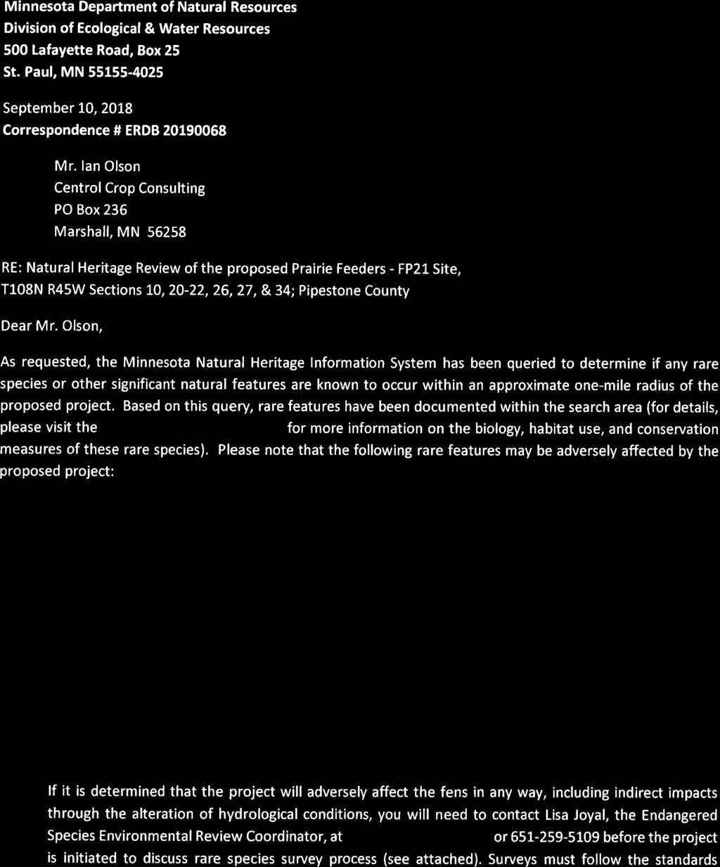
69 ATTACHMENT O
70
71
72
73 rn, DEPARTMENT OF ADMINISTRATION STATE HISTORIC PRESERVATION OFFICE ATTACHMENT P l l MINNESOTA HISTORIC PRESERVATION OFFICE August 10, 2018 Mr. Ian Olson Central Crop Consulting 351 Burlington Circle PO Box 236 Marshall, MN RE: Prairie Feeders LLC - FP21,Site Construct a swine facility, to include manure pit, animal mortality structure, and well T108 R45 S21 SW Fountain Prairie Twp., Pipestone County SHPO Number: j.j ) Dear Mr. Olson: Thank you for consulting with our office during the preparation of an Environmental Assessment Worksheet for the above referenced project. Based on our review of the project information, we conclude that there are no properties listed in the National or State Registers of Historic Places, and no known or suspected archaeological properties in the area that will be affected by this project. Please note that this comment letter does not address the requirements of Section 106 of the National Historic Preservation Act of 1966 and 36 CFR 800. If this project is considered for federal financial assistance, or requires a federal permit or license, then review and consultation with our office will need to be initiated by the lead federal agency. Be advised that comments and recommendations provided by our office for this state-!evel review may differ from findings and determinations made by the federal agency as part of review and consultation under Section 106. Please contact our Environmental Review Program at (651) if you have any questions regarding our coi:nments on this project. Sincerely, Sarah J. Beimers Environmental Review Program Manager MINNESOTA STATE HISTORIC PRESERVATION OFFICE 50 Sherburne Avenue Administration Building 203 Saint Paul, Minnesota mn.gov/ admin/shpo/ mnshpo@lstate.mn.us AN EQUAL OPPORTUNllY AND SERVICE PROVIDER
74
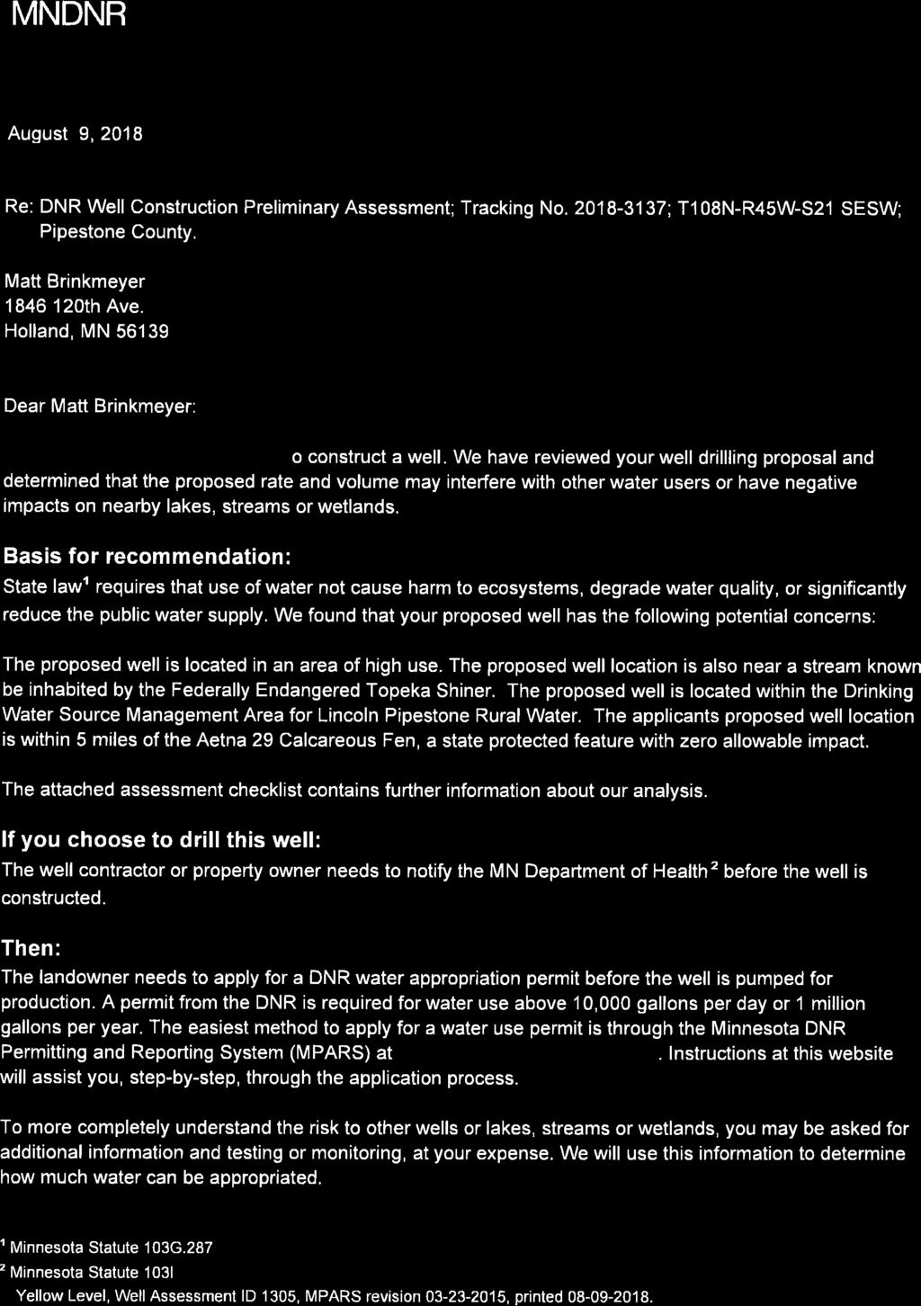

75 ATTACHMENT Q
76
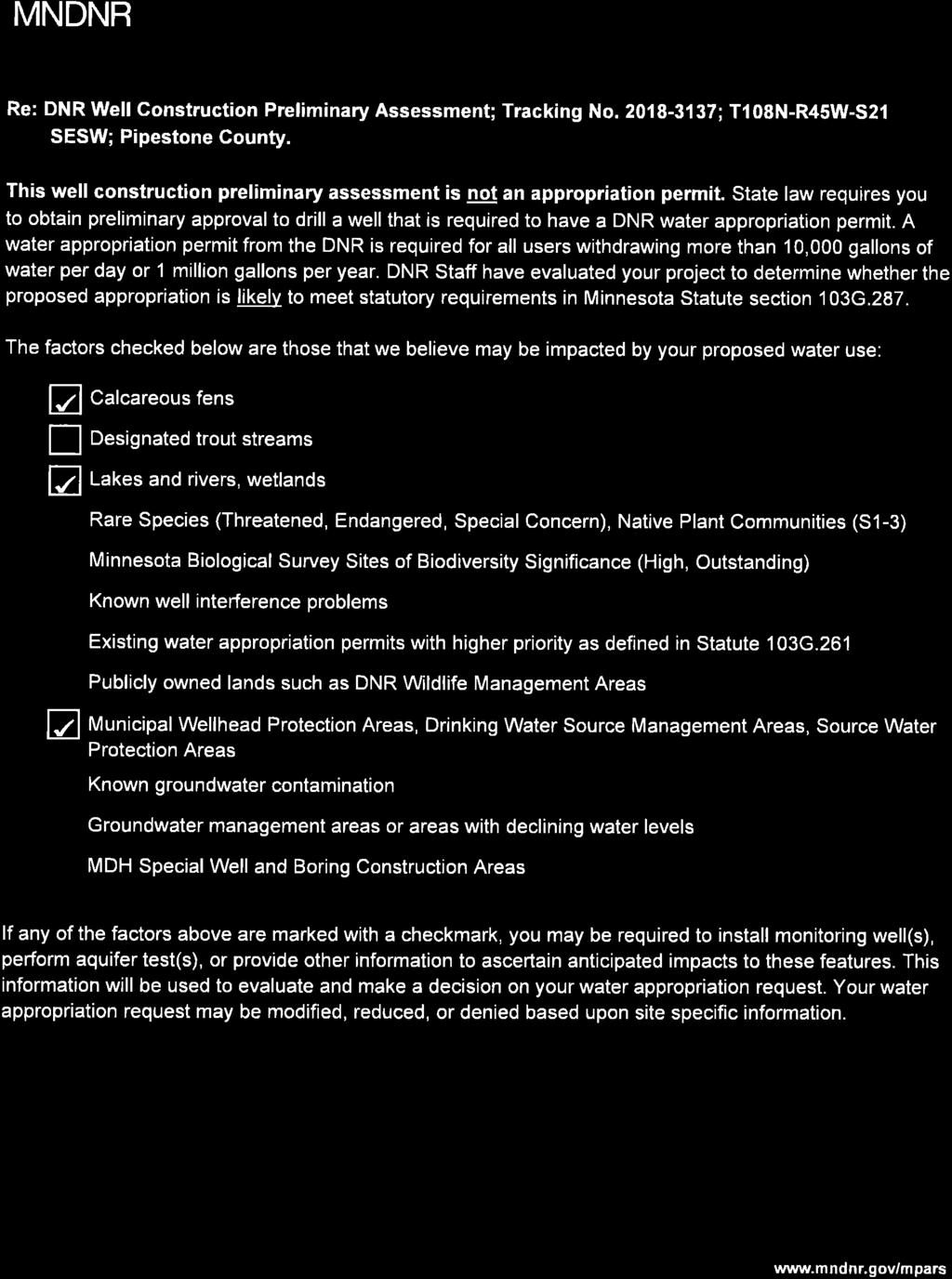

77
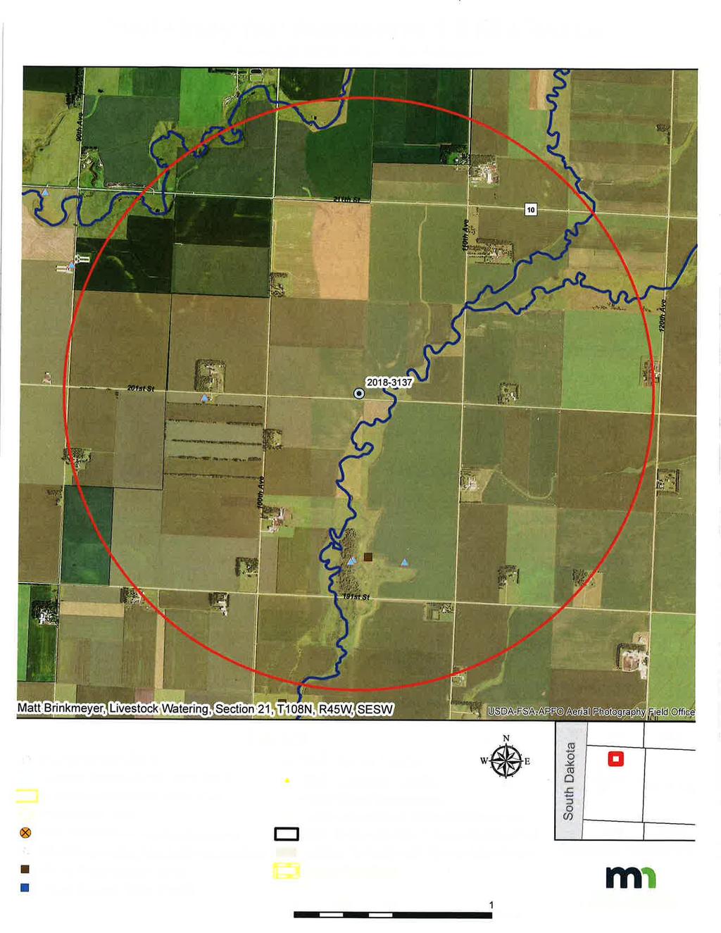
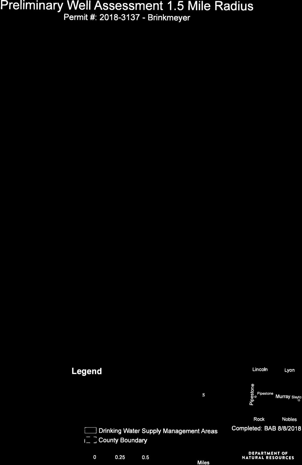

78
79