PUBLIC NOTICE LOS ANGELES DISTRICT APPLICATION FOR PERMIT. University of California Santa Barbara North Campus Open Space (NCOS) Restoration Project
|
|
|
- Annabella Green
- 5 years ago
- Views:
Transcription
 Restoration Project Public Notice/Application")
1 PUBLIC NOTICE U.S. ARMY CORPS OF ENGINEERS LOS ANGELES DISTRICT BUILDING STRONG APPLICATION FOR PERMIT University of California Santa Barbara North Campus Open Space (NCOS) Restoration Project Public Notice/Application No.: SPL TS Project: University of California Santa Barbara - North Campus Open Space Restoration Project Comment Period: June 21, 2016 through July 21, 2016 Project Manager: Theresa Stevens; ; theresa.stevens@usace.army.mil Applicant University of California Santa Barbara Cheadle Center for Biodiversity and Ecological Restoration Santa Barbara, California Contact Lisa Stratton stratton@ccber.ucsb.edu Location The project is located on three abutting parcels owned by the University of California Santa Barbara (UCSB), collectively known as the acres of the North Campus Open Space (NCOS). The NCOS is located west of Storke Road, south of Phelps Road, north of Devereux Slough and the UCSB Coal Oil Point Reserve, and east of Ellwood Mesa. The NCOS is adjacent to the city of Goleta, Santa Barbara County, California (latitude , longitude ). Activity A Department of the Army (DA) permit is required for several project elements, described below. The proposed project would impact approximately 9.05 acres of wetland and non-wetland waters of the United States, and approximately 0.06 acres of tidally influenced (navigable) waters of the United States (total proposed impact is 9.11 acres of waters of the United States). The proposed project would be accomplished by excavating approximately 355,000 cubic yards (cy) of fill that was placed in the upper reach of Devereux Slough to construct the Ocean Meadows Golf Course (OMGC) in the 1960 s. During construction of the OMGC, the upper reach of Devereux Slough and Devereux Creek was filled, channelized and cut off from tidal inundation from the lower Devereux Slough. The excavated area would be contoured following mass excavation to establish elevations and soil conditions conducive to the habitat restoration goals described in the Draft NCOS Restoration Plan (Restoration Plan, ESA, May 2016). No work in Devereux Slough downstream of the Devereux Creek bridge on Venoco Road is proposed. Excavated material would be placed in uplands, stabilized and revegetated with appropriate native vegetation as described in the Restoration Plan. Most of the excavated material would be placed in an upland area south of the excavation area (aka, the South Parcel), although some of the excavated material would be placed in uplands elsewhere on the project site to facilitate construction of the formal trail network, recreational bridge crossings, and other public amenities. The fill material used to create the OMGC was obtained from the South Parcel in the 1960 s.
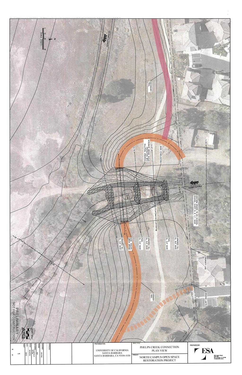
2 Pedestrian and multi-use trails would be constructed around the perimeter of the site to allow for public access (which is currently ongoing on an informal network of trails); no vehicular access would be allowed. The project would be completed in two phases. Phase 1 would include grading and revegetation of the area between the northern boundary of the project site and the primary trail alignment, adjacent to existing residential areas (Whittier parcel and Phelps Creek area) as well as minor grading in areas outside of the flood plain adjacent to the public access trail alignment. Phase 1 would include excavation/cut of approximately 70,500 cy of material and placement/fill of approximately 70,500 cy of material along the perimeter of the project site and the South Parcel and removal of OMGC infrastructure (e.g., concrete golf cart paths, irrigation lines, etc.). Phase 2 would include excavation/cut of approximately 279,500 cy of material, and placement/fill of approximately 279,500 cy of material on the South Parcel and revegetation and construction of the Phelps Creek bridge and sill structure (described below). Excavation along Devereux Creek would occur in foot-long lifts so as to reduce the area disturbed at any given time. Excavation and contouring would result in elevations from 3.5 feet NAVD to 9 feet NAVD 1 on the former OMGC parcel. Four bridges (A though D) of varying widths and lengths would be constructed across existing drainages and/or low lying wetlands to reduce the impact of uncontrolled public access on restored wetland habitats. Bridge A (Sierra Madre crossing) would be a concrete culvert type structure and supported by two, four-foot-deep by one-foot-wide cut off walls and would require approximately 102 cy of fill at the approaches and as a result of the support structures; this crossing would be 100-feetlong by 12-feet-wide. Bridge B (Whittier Timber boardwalk) would be supported by twenty pre-cast concrete piles and would require approximately 11 cy of fill at the approaches; this crossing would be 100-feet-long by 12-feet-wide e. Bridge C (Devereux bridge) would be supported by six (6) cast-indrilled-hole piles at 100-foot intervals and would require approximately five (5) cy of fill at the approaches; this bridge would be 300-feet-long by 12-feet-wide. Bridge D (Phelps Creek crossing) would be supported by four (4) cast-in-drilled-hole piles at 100-foot intervals and would require approximately seven (7) cy of fill at the approaches; this bridge would be 100-feet-long by 12-feetwide. At the outlet of Phelps Creek, rock would be installed on the banks to reduce erosion and scour at the bridge. In addition, a two-stepped pool sill structure would be constructed of rock. This structure would provide grade control in this transition area which would have a three-foot drop in elevation from the outlet of Phelps Creek to the OMGC parcel (from 8 feet NAVD to 5 feet NAVD); each pool would be approximately one to two feet deep. This structure would also provide a freshwater-tosaline transition zone from Phelps Creek to the restored wetland area downstream, reduce channel incision and/or headcutting in Phelps Creek, dissipate energy during high flows from Phelps Creek during the rainy season, and prevent tidal water from entering Phelps Creek or the El Encanto Drain. This project element would consist of approximately 1,000 cy of rock placed over an area of approximately 6,400 square feet (see attached design drawing). Riparian vegetation would be incorporated into the structures or planted along the channel banks. The proposed finished grade of the rock sill structure would be at or below existing grade. The project would also remove an existing sheet pile and rock sill located immediately north of the existing bridge at Devereux Creek along Venoco Road to the Venoco oil company facilities. Removal of the sill would take place toward the end of the Phase 2 construction period as the sill would help trap sediment during excavation of the upstream areas. Removal of the sill would require construction of a temporary coffer dam to create a dry work area. This project element would temporarily impact approximately 0.06 acres of navigable waters of the United States (i.e., waters subject to the ebb and flood of the tide). This project element would allow salt water from Devereux Slough to flow into the restored areas north of this bridge on high tides. The existing bridge would remain in place for use by 1 Design elevations are based on the North American Vertical Datum of 1988 (NAVD); mean higher high water at a nearby tide gage (NOAA Station No ) is 5.27 feet NAVD. 2
3 Venoco to access its existing oil and gas facilities on Ellwood Mesa, and by emergency responders. Venoco Oil, Inc. has applied for a Demolition and Reclamation permit with Santa Barbara County and the process is underway to demolish the oil facilities and restore the site to natural conditions. Therefore, in the future, Venoco Oil, Inc. will not require access. Temporary culvert or bridge crossings, and associated fill of earthen material would be installed during construction activities for the purpose of equipment access. These temporary fills and/or structures would be removed upon completion of mass grading. In addition to the bridges/crossings, a 100-foot by 12-foot timber overlook and a 25-foot by 25-foot timber viewing platform may be constructed in non-jurisdictional uplands adjacent to the wetland restoration area; these would be supported by treated timber piles. Construction activities would take place over a period of approximately two (2) years. For more information see Additional Information section below and attached drawings and maps (11 x 17 inch format). Interested parties are hereby notified an application has been received for a Department of the Army permit for the activity described herein and shown on the attached drawing(s). We invite you to review today s public notice and provide views on the proposed work. By providing substantive, sitespecific comments to the Corps Regulatory Division, you provide information that supports the Corps decision-making process. All comments received during the comment period become part of the record and will be considered in the decision. This permit will be issued, issued with special conditions, or denied under Section 404 of the Clean Water Act and Section 10 of the Rivers and Harbors Act. Comments should be mailed to: DEPARTMENT OF THE ARMY LOS ANGELES DISTRICT, U.S. ARMY CORPS OF ENGINEERS REGULATORY DIVISION ATTN: Theresa Stevens, Ph.D Alessandro Drive, Suite 110 Ventura, CA Alternatively, comments can be sent electronically to: theresa.stevens@usace.army.mil The mission of the U.S. Army Corps of Engineers Regulatory Program is to protect the Nation's aquatic resources, while allowing reasonable development through fair, flexible and balanced permit decisions. The Corps evaluates permit applications for essentially all construction activities that occur in the Nation's waters, including wetlands. The Regulatory Program in the Los Angeles District is executed to protect aquatic resources by developing and implementing short- and long-term initiatives to improve regulatory products, processes, program transparency, and customer feedback considering current staffing levels and historical funding trends. Corps permits are necessary for any work, including construction and dredging, in the Nation's navigable water and their tributary waters. The Corps balances the reasonably foreseeable benefits and detriments of proposed projects, and makes permit decisions that recognize the essential values of the Nation's aquatic ecosystems to the general public, as well as the property rights of private citizens who want to use their land. The Corps strives to make its permit decisions in a timely manner that minimizes impacts to the regulated public. During the permit process, the Corps considers the views of other Federal, state and local agencies, interest groups, and the general public. The results of this careful public interest review are 3
4 fair and equitable decisions that allow reasonable use of private property, infrastructure development, and growth of the economy, while offsetting the authorized impacts to the waters of the United States. The permit review process serves to first avoid and then minimize adverse effects of projects on aquatic resources to the maximum practicable extent. Any remaining unavoidable adverse impacts to the aquatic environment are offset by compensatory mitigation requirements, which may include restoration, enhancement, establishment, and/or preservation of aquatic ecosystem system functions and services. Evaluation Factors The decision whether to issue a permit will be based on an evaluation of the probable impact including cumulative impacts of the proposed activity on the public interest. That decision will reflect the national concern for both protection and utilization of important resources. The benefit, which reasonably may be expected to accrue from the proposal must be balanced against its reasonably foreseeable detriments. All factors which may be relevant to the proposal will be considered including the cumulative effects thereof. Factors that will be considered include conservation, economics, aesthetics, general environmental concerns, wetlands, cultural values, fish and wildlife values, flood hazards, flood plain values, land use, navigation, shoreline erosion and accretion, recreation, water supply and conservation, water quality, energy needs, safety, food production and, in general, the needs and welfare of the people. In addition, if the proposal would discharge dredged or fill material, the evaluation of the activity will include application of the EPA Guidelines (40 CFR Part 230) as required by Section 404 (b)(1) of the Clean Water Act. The Corps of Engineers is soliciting comments from the public; Federal, state, and local agencies and officials; Indian tribes; and other interested parties in order to consider and evaluate the impacts of this proposed activity. Any comments received will be considered by the Corps of Engineers to determine whether to issue, modify, condition or deny a permit for this proposal. To make this decision, comments are used to assess impacts on endangered species, historic properties, water quality, general environmental effects, and the other public interest factors listed above. Comments are used in the preparation of an Environmental Assessment and/or an Environmental Impact Statement pursuant to the National Environmental Policy Act. Comments are also used to determine the need for a public hearing and to determine the overall public interest of the proposed activity. Preliminary Review of Selected Factors EIS Determination- A preliminary determination has been made an environmental impact statement (EIS) is not required for the proposed project. Water Quality- The applicant is required to obtain water quality certification, under Section 401 of the Clean Water Act, from the California Regional Water Quality Control Board. Section 401 requires any applicant for a DA permit provide proof of water quality certification to the Corps of Engineers prior to permit issuance. Coastal Zone Management- The proposed project is located in the coastal zone. For those projects in or affecting the coastal zone, the Federal Coastal Zone Management Act requires that prior to issuing the Corps authorization for the project, the applicant must obtain concurrence from the California Coastal Commission the project is consistent with the State's Coastal Zone Management Plan. Essential Fish Habitat (EFH)- Preliminary determinations indicate the proposed activity may adversely affect EFH and federally managed species in the Pacific Groundfish Fishery Management 4
5 Plan. Therefore, formal consultation under Section 305(b)(2) of the Magnuson-Stevens Fishery Conservation and Management Act (MSA) is required. The Corps federal action would potentially result in sediment deposition in Devereux Slough, downstream from the project area. The FWS is the lead federal agency for compliance with the Magnuson-Stevens Fishery Conservation and Management Act and is completing consultation with the National Marine Fisheries Service (NMFS) on potential effects of the proposed project on EFH and managed fish species. Cultural Resources- Preliminary determinations indicate the Corps federal action may encounter cultural resources during infrastructure removal and construction, and/or mass grading. The U.S. Fish and Wildlife Service is the lead federal agency for compliance with the National Historic Preservation Act. As such, the FWS is completing consultation requirements in accordance with Section 106 of the National Historic Preservation Act with the State Historic Preservation Officer. Endangered Species- Three federally-listed endangered or threatened species may occur in the project area or vicinity. These include the tidewater goby (Eucyclogobius newberryi), western snowy plover (Charadrius nivosus spp. nivosus), California red-legged frog (Rana draytonii). The endangered Ventura marsh milk vetch (Astragalus pycnostachyus var. lanosissimus), a federally listed endangered species does not occur in the project area but a population was planted in the adjacent Coal Oil Point Reserve several years ago. The southern steelhead (Oncorhynchus mykiss) is not known to occur in Devereux Slough or the Devereux Creek watershed. There is no designated critical habitat in the project area. The FWS is the lead federal agency for compliance with the section 7 of the Endangered Species Act and is completing consultation on behalf of the Corps for listed species subject to the FWS jurisdiction (i.e., tidewater goby, California red-legged frog, western snowy plover, Ventura marsh milk vetch). The FWS is also completing consultation with the NMFS for potential effects on southern steelhead. Public Hearing- Any person may request, in writing, within the comment period specified in this notice, that a public hearing be held to consider this application. Requests for public hearing shall state with particularity the reasons for holding a public hearing. Proposed Activity for Which a Permit is Required A DA permit is required for impacts to approximately 9.11 acres of jurisdictional waters of the United States and wetlands during OMGC infrastructure removal, mass excavation/grading and contouring, construction of four new permanent bridge/boardwalk crossings of jurisdictional waters of the United States including wetlands for the purpose of public access, construction of a rock steppedpool sill structure at the outlet of Phelps Creek, removal of the rock sill at the Venoco/Devereux Creek bridge, and temporary fills and structures (e.g., turbidity curtains, silt fencing, coffer dams, pipe diversions, etc.) for construction access and dewatering. Basic Project Purpose- The basic project purpose comprises the fundamental, essential, or irreducible purpose of the proposed project, and is used by the Corps to determine whether the applicant's project is water dependent (i.e., requires access or proximity to or siting within the special aquatic site to fulfill its basic purpose). Establishment of the basic project purpose is necessary only when the proposed activity would discharge dredged or fill material into a special aquatic site (e.g., wetlands, pool and riffle complex, mudflats, coral reefs). The basic project purpose of the proposed project is to modify Devereux Creek and jurisdictional waters/wetlands adjacent to Devereux Creek to re-establish estuarine wetlands and transitional riparian areas on the NCOS. Because the basic project purpose would only be met by discharging dredged or fill material in an existing jurisdictional area, and removing an existing structure from navigable waters of the U.S., the project is considered water dependent. 5
6 Overall Project Purpose- The overall project purpose serves as the basis for the Corps' 404(b)(1) alternatives analysis and is determined by further defining the basic project purpose in a manner that more specifically describes the applicant's goals for the project, and which allows a reasonable range of alternatives to be analyzed. The purpose of the project is to re-establish approximately 100 acres of native estuarine wetlands, riparian and upland habitats in the Devereux Creek watershed, north of Devereux Slough by restoring hydrologic and hydraulic connectivity of the project area to Devereux Slough. The overall project purpose is to restore the Devereux Slough ecosystem to its approximate historic aerial extent and re-establish hydraulic and hydrologic connectivity to Devereux Slough as the area existed prior to construction of the OMGC and the sill at the Venoco/Devereux Creek bridge, and provide public access and connectivity with Ellwood Mesa for passive recreational, research and educational activities and uses. Additional Project Information In the past few years, the three project area parcels were acquired by UCSB as described in the permit application and the Draft Mitigated Negative Declaration that was prepared and circulated by UCSB (dated February 2016). The proposed project has been designed by a consortium of UCSB faculty and research scientists, funding entities, resources agencies, with input from the public. The construction, revegetation, site monitoring, and management would be supervised by research scientists with the Cheadle Center for Biodiversity and Ecological Restoration (CCBER). Target habitats to be re-established include: subtidal areas and mudflats, salt marsh, fresh/brackish wetlands, riparian habitat, bioswales, backdune woodland scrub, native grassland/vernal pool, and coastal sage scrub as described in the Restoration Plan. There are three agencies with potential federal lead agency status over the proposed project (the U.S. Fish and Wildlife Service (FWS), Corps, and Caltrans 2 ). Together, the FWS, the Corps and Caltrans determined the FWS is the federal lead agency for compliance with section 7 of the Endangered Species Act, the Magnuson-Stevens Fishery Conservation and Management Act, and the section 106 of the National Historic Preservation Act due to its cumulative federal control and responsibility over the project in the form of federal funding for the overall project. While the FWS is the lead federal agency among FWS, the Corps and Caltrans, each federal agency would prepare its own NEPA compliant decision document to document its unique and final agency action. In addition to FWS funding, grant funding and commitments by UCSB have been secured to cover the costs of construction, revegetation, and post-construction monitoring activities and land management. The Corps is cooperating with the FWS to insure the consultation processes required by the aforementioned federal statutes adequately describe and legally cover the Corps federal action (i.e., issuance of a DA permit to discharge dredged or fill material into, and conduct work or install structures in waters of the United States, including wetlands). The South Parcel was substantially degraded in the 1960 s as the topsoil was excavated and placed in the adjacent Devereux Creek and floodplain to construct the OMGC and multiple drainage swales were cut. To this day, the subsoil remains exposed in some patches, and much of the South Parcel is sparsely covered with natives and non-natives; likely a result of poor soil quality and man- 2 Caltrans has provided some funding for the proposed public access trail network and has federal lead agency status because. on July 1, 2007, the Federal Highway Administration (FHWA) assigned, and the California Department of Transportation (Caltrans) assumed, all the United States Department of Transportation (USDOT) Secretary s responsibilities under the National Environmental Policy Act (NEPA) pursuant to section 6005 of the Safe, Accountable, Flexible and Efficient Transportation Equity Act, A Legacy for Users (SAFETEA-LU) codified at 23 U.S.C. 327(a)(2)(A). Caltrans assumed all of FHWA s responsibilities under NEPA for the proposed project on the California s State Highway System (SHS) and for federal aid, local streets and roads projects, under FHWA s Surface Transportation Project Delivery Pilot Program, pursuant to 23 CFR part 773. Caltrans also assumed all of FHWA s responsibilities for environmental coordination and consultation under other federal environmental laws pertaining to the review or approval of projects under the Pilot Program. Thus, for purposes of carrying out the responsibilities assumed under the Pilot Program, Caltrans is deemed to be acting as the FHWA with respect to the environmental review, consultation, and other action required under those responsibilities. 6

7 made disturbances (drainage swales, informal trail network, planted windrows, oil and gas facilities). Patches of willow riparian vegetation occur in the man-made drainage swales but the swales are not considered jurisdictional by the Corps. Proposed Mitigation No mitigation has been proposed by the applicant; the proposed project is considered self-mitigating. However, standard special conditions will be included in the DA permit to address the potential discharge of pollutants to waters of the United States, endangered species protection, cultural resources protection, site monitoring and performance reporting, and the like. Best management practices (e.g., erosion control throughout the construction period, phased excavation) have been proposed by the applicant to minimize indirect and cumulative impacts associated with mass grading in the project area and soil placement on the South Parcel, and protect endangered and sensitive species and habitats. Mitigation measures may be required as a result of comments received in response to this public notice, the applicant's response to those comments, and/or the need for the project to comply with the 404(b)(1) Guidelines and the Corps public interest requirements. Proposed Special Conditions Special Conditions will be required and may include conditions to address comments received in response to this public notice, the applicant's response to those comments, and/or the need for the project to comply with the 404(b)(1) Guidelines and the Corps public interest requirements. For additional information please call Theresa Stevens, Ph.D., of my staff at or via at theresa.stevens@usace.army.mil. This public notice is issued by the Chief, Regulatory Division. Regulatory Program Goals: To provide strong protection of the nation's aquatic environment, including wetlands. To ensure the Corps provides the regulated public with fair and reasonable decisions. To enhance the efficiency of the Corps administration of its regulatory program. DEPARTMENT OF THE ARMY LOS ANGELES DISTRICT, U.S. ARMY CORPS OF ENGINEERS VENTURA FIELD OFFICE 2151 ALESSANDRO DRIVE, SUITE 110 VENTURA, CA

8

9
10
11

12
13
14

15
16
17
18
19
20
21
22
23