CITY OF BANNING Initial Study/Negative Declaration
|
|
|
- Melanie Washington
- 5 years ago
- Views:
Transcription
1 CITY OF BANNING Initial Study/Negative Declaration General Plan Amendment and Rezoning Related to Regional Housing Needs Assessment City of Banning Community Development Department 99 E. Ramsey Street Banning, California March 2012 Zai Abu Bakar Community Development Director (951)
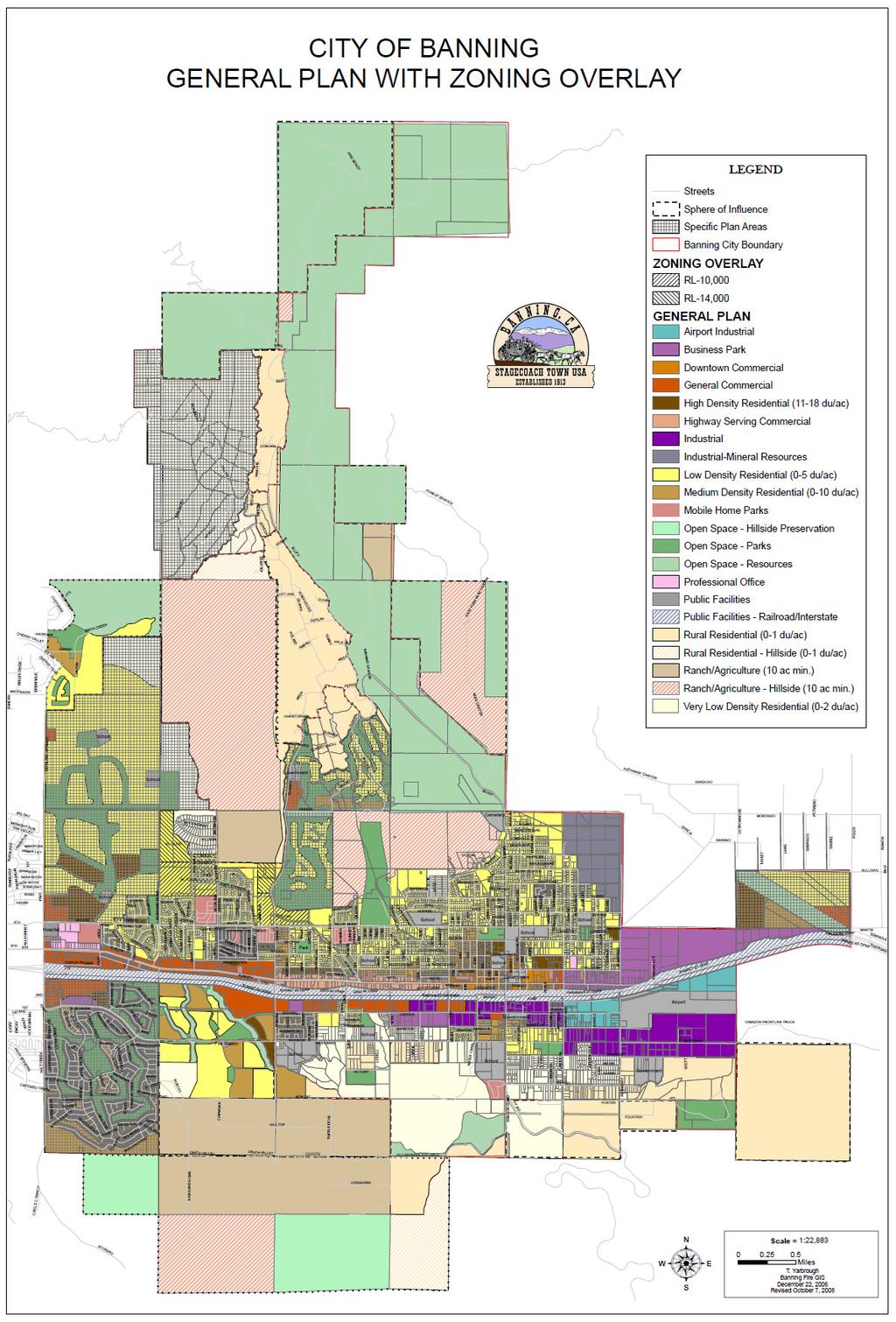
2 TABLE OF CONTENTS Page No. EXECUTIVE SUMMARY 1 1. INTRODUCTION 5 2. EVALUATION OF ENVIRONMENTAL IMPACTS 5 3. ENVIRONMENTAL DETERMINATION 7 4. PROJECT DESCRIPTION 8 5. ENVIRONMENTAL ANALYSIS CHECKLIST EXPLANATION OF THE ITEMS MARKED ON THE ENVIRONMENTAL CHECKLIST FORM INCORPORATION BY REFERENCE LIST OF PREPARERS 29 EXHIBIT A (Site Maps) 40 EXHIBIT B (General Plan Land Use Map with Zoning Overlay) 42 i

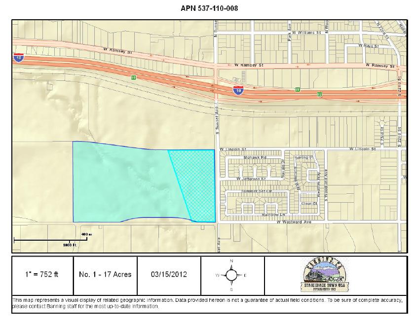
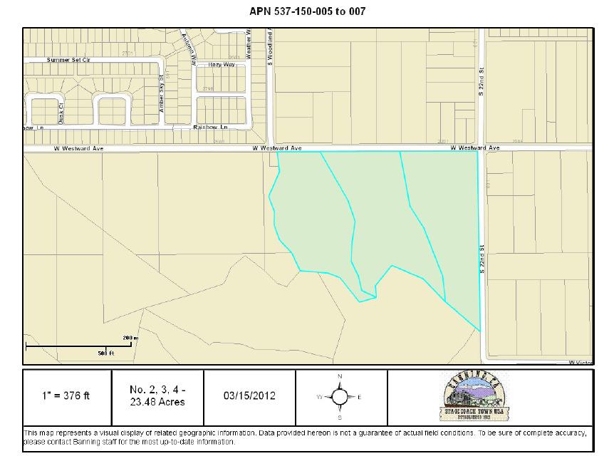
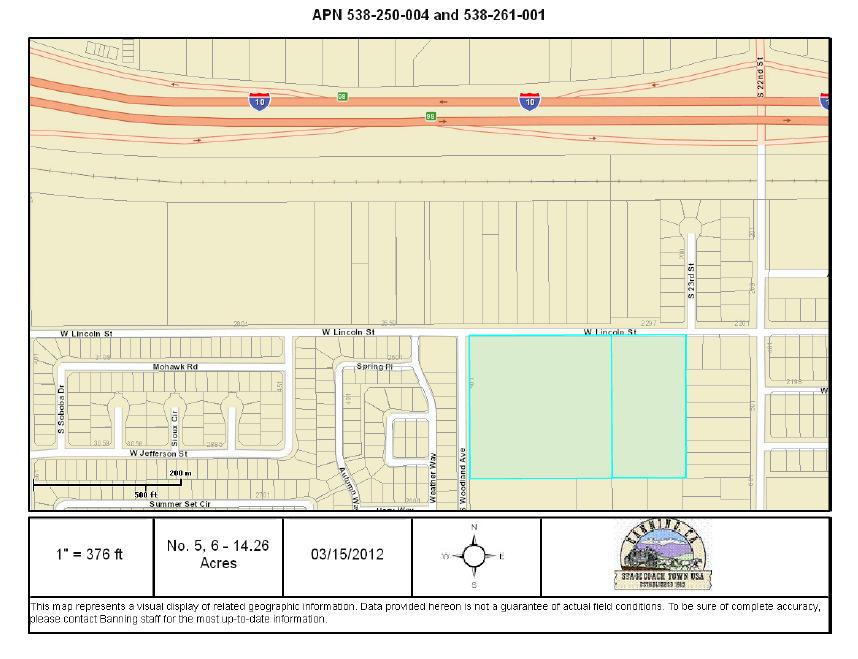
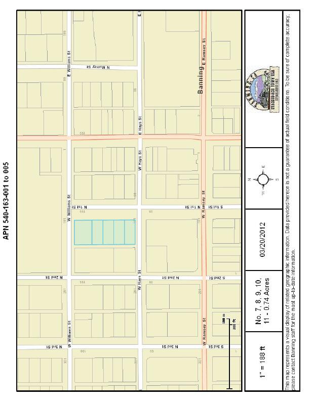
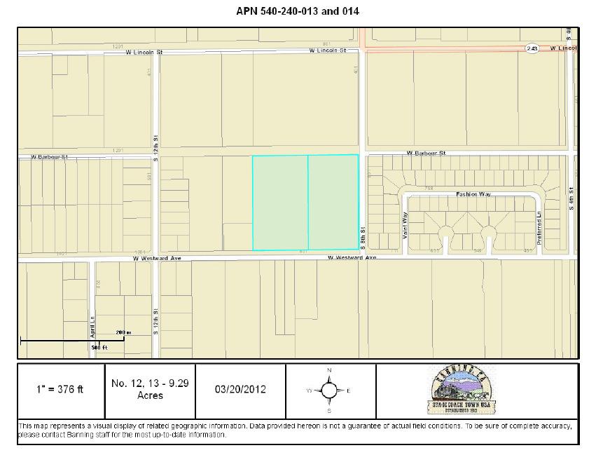
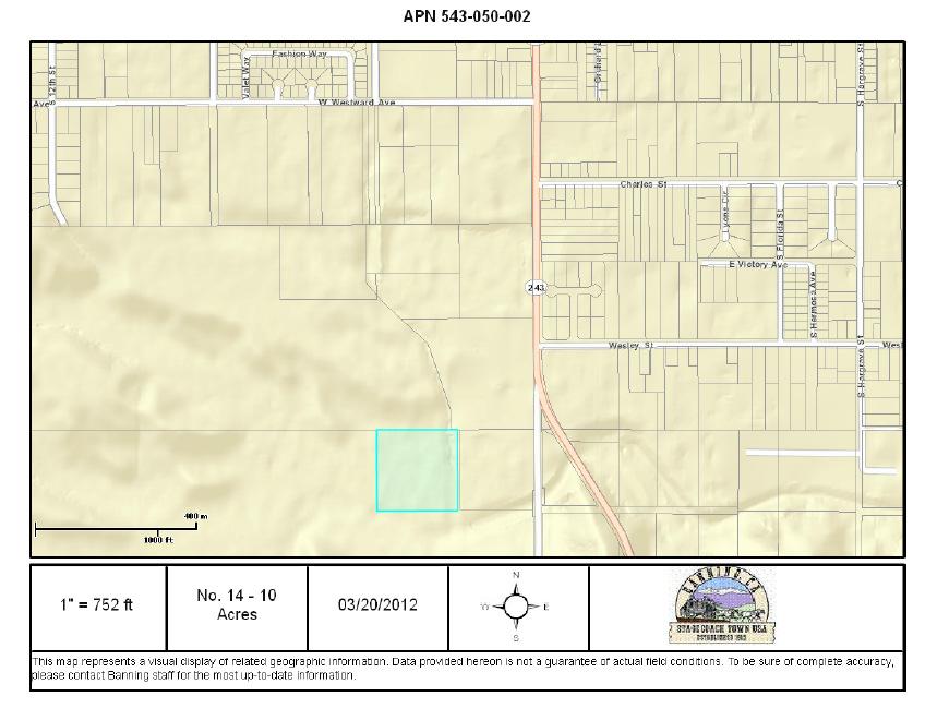
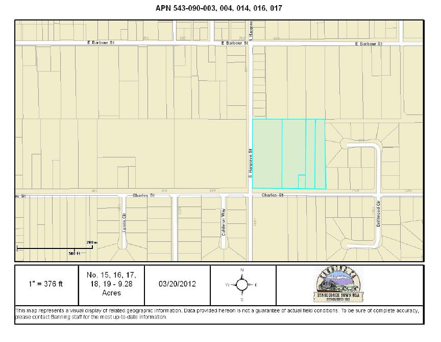
3 City of Banning Initial Study/Negative Declaration for General Plan Amendment and Rezoning Related to Regional Housing Needs Assessment EXECUTIVE SUMMARY This Initial Study assesses the potential environmental impacts of the proposed project. The purpose of the project is to amend the General Plan (GP) Land Use Map and Zoning Overlay designating Very High Density Residential (VHDR) districts to comply with State of California Department of Housing and Community Development requirements for housing (see Figure 1 for a list of parcels). The proposed project consists of approximately acres of land at various locations in the City (see Figure 3 for locations). Included with this project is the amendment of the GP Land Use Map and Zoning Overlay designating five parcels of land as Very Low Density Residential (VLDR) from Industrial (I) (see Figure 2 for a list of parcels). The included parcels amount to approximately 9.28 acres. Individual maps of the parcels in question are included in Exhibit A. The results of the Initial Study show that there is no substantial evidence that the project would have a significant effect on the environment. A Negative Declaration is being recommended for adoption. City of Banning, Riverside County California 1
4 No. Assessor s Parcel Number Acres Figure 1- VHDR Parcel List Existing GP Land Use Designation Existing Zoning Proposed Land Use Designation Proposed Zoning MDR/HDR MDR/HDR VHDR VHDR VLDR VLDR VHDR VHDR VLDR VLDR VHDR VHDR VLDR VLDR VHDR VHDR VLDR VLDR VHDR VHDR VLDR VLDR VHDR VHDR DC DC DC-30 DC DC DC DC-30 DC DC DC DC-30 DC DC DC DC-30 DC DC DC DC-30 DC VLDR VLDR VHDR VHDR VLDR VLDR VHDR VHDR VLDR VLDR VHDR VHDR Total Very High Density Residential (VHDR) (20 to 30 du/acre). The Very High Density Residential zoning district allows housing that is generally affordable multi-family in character such as garden apartments, condos, flats, townhouses, and low-rise multi-family complexes. The clustering of condominiums and townhomes is appropriate with the provision of common area amenities. Home Occupations may be appropriate with approval of a Home Occupation permit. No. Assessor s Parcel Number Acres Figure 2- VLDR Parcel List Existing GP Land Use Designation Existing Zoning Proposed Land Use Designation Proposed Zoning Industrial Industrial VLDR VLDR Industrial Industrial VLDR VLDR Industrial Industrial VLDR VLDR Industrial Industrial VLDR VLDR Industrial Industrial VLDR VLDR Total 9.28 Very Low Density Residential (VLDR) (0-2 du/acre). This zoning district allows detached single-family homes at a density of up to 2 units per acre. May be appropriate for bed & breakfast and similar uses. Animal keeping is permitted according to Zoning restrictions. 2
5 Explanations for other zoning designations referenced: Medium Density Residential (MDR) (0-10 du/acre). This zoning district allows the development of attached and detached single family homes, in traditional subdivisions and planned communities. Also allows condominiums and townhomes, garden apartments and duplexes, with the provision of common area amenities and open space. The clustering of condominiums and townhomes may be appropriate with the provision of common area amenities and open space. Bed & breakfasts and similar uses may be appropriate with the approval of a conditional use permit. Home Occupations are permitted with approval of a Home Occupation permit. May also be appropriate for convenience retail commercial ("corner store" type development such as convenience stores, grocery or green grocer, video rental, drug stores, sit down restaurants, coffee shops or coffee bars or similar uses), less than 5,000 square feet in total square footage, with approval of a conditional use permit. Mixed use projects, which combine residential and commercial uses, are appropriate with approval of a Planned Unit Development. High Density Residential (HDR) (11-18 du/acre). Allows condominiums and townhomes, as well as apartments with the provision of common area amenities and open space. The clustering of condominiums and townhomes is appropriate with the provision of common area amenities and open space. Mobile home parks and subdivisions with the provision of common area amenities and open space may also be appropriate, with the approval of a conditional use permit. Home Occupations may be appropriate with approval of a Home Occupation permit. Downtown Commercial (DC). This District occurs on Ramsey Street, between 8th Street and Hargrave Street on the west and east, by Interstate 10 on the south, and by Williams and Nicolet on the north. This area is the City's traditional commercial core, and has special significance to the community because small scale commercial retail and office uses, services, restaurants, and entertainment retail are the primary uses in this district. Mixed Use, residential land uses in combination with commercial businesses, are also encouraged. Bed & breakfasts, hotels and motels are also appropriate in this district. Downtown Commercial (DC-30) (18-30 du/ac for mixed uses). This District occurs within the DC zoning district on Ramsey Street, between 8th Street and Hargrave Street on the west and east, by Interstate 10 on the south, and by Williams and Nicolet on the north. This area is the City's traditional commercial core, and has special significance to the community because small scale commercial retail and office uses, services, restaurants, and entertainment retail are the primary uses in this district. Mixed Use, residential land uses in combination with commercial businesses, are also encouraged. Bed & breakfasts, hotels and motels are also appropriate in this district. Industrial (I). This district includes industrial parks and freestanding industrial users. Examples of permitted uses include light and medium intensity manufacturing operations, warehousing and distribution, ministorage, and associated offices. Commercial recreation facilities, auto storage and repair are also allowed. Retail uses ancillary to the industrial use are also appropriate. 3

6 7, 8, 9, , 3, 4 5, 6 12, Figure 3 Parcel Locations 4
7 1. INTRODUCTION Purpose and Scope This Initial Study serves as the environmental review of the proposed Project, as required by the California Environmental Quality Act (CEQA), Public Resources Code Section et seq., the State CEQA Guidelines, and the City of Banning Local Guidelines for Implementing CEQA. In accordance with Section of the State CEQA Guidelines, the City is required to prepare an Initial Study to determine if the Project may have a significant effect on the environment. This Initial Study is intended to be an informational document providing the Planning Commission, City Council, other public agencies, and the general public with an objective assessment of the potential environmental impacts that could result from the implementation of the Project. Incorporation by Reference This Initial Study is based in part on the information and analysis contained in other environmental and planning documents. These documents are hereby incorporated by reference in their entirety into this Initial Study, as authorized by Section of the State CEQA Guidelines. All of the documents incorporated by reference are listed in Section 7 of this Initial Study. 2. EVALUATION OF ENVIRONMENTAL IMPACTS An Environmental Checklist Form (Form) has been used to evaluate the potential environmental impacts associated with the proposed Project. The Form has been prepared by the Resources Agency of California to assist local governmental agencies, such as the City of Banning, in complying with the requirements of the Statutes and Guidelines for implementing the California Environmental Quality Act. This Form has been used by the City of Banning to review the effects of the proposed Project with respect to the following environmental factors. The environmental factors checked below would be potentially affected by this project, involving at least one impact that is Potentially. Based on the analysis contained in this Initial Study, the following environmental factors are affected by the proposed project. Aesthetics Hydrology/Water Quality Public Services Agriculture Resources Hazards & Hazardous Materials Recreation Air Quality Land Use and Planning Transportation/Traffic Biological Resources Mineral Resources Utilities/Service Systems Cultural Resources Noise Mandatory Findings of Geology/Soils Greenhouse Gas Emissions Population/Housing Significance 5
8 In the Form, a series of questions is asked about the Project for each of the above-listed environmental factors. A brief explanation is then provided for each question on the Form. There are four possible responses to each question: A. Potentially. This response is used when the Project has the potential to have an effect on the environment that is considered to be significant and adverse. B. Potentially Unless Mitigation Incorporated. This response is used when the Project has the potential to have a significant impact, which is not expected to occur because: Mitigation measures have been incorporated into the Project design in order to reduce the impact to a less than significant level; or, Adherence to existing policies, regulations, and/or design standards would reduce the impact of the Project to a less than significant level. C. Less Than. This response is used when the potential environmental impact of the Project is determined to be below known or measurable thresholds of significance and thus would not require mitigation. D. No. This response is used when the proposed Project does not have any measurable impact. 6
9 3. ENVIRONMENTAL DETERMINATION On the basis of this initial evaluation, I find that: The proposed Project could not have a significant effect on the environment, and a Negative Declaration will be prepared. Although the proposed Project could have a significant effect on the environment, there will not be a significant effect in this case because the mitigation measures, described in Exhibit C (attached), have been added to the Project. A Mitigated Negative Declaration will be prepared. The proposed Project may have a significant effect on the environment, and an Environmental Report is required. The proposed Project may have a potentially significant impact unless mitigation is incorporated, but at least one of the impacts has been: 1) adequately analyzed in an earlier document pursuant to applicable legal standards and 2) addressed by mitigation measures based on the earlier analysis as described on the attached sheets. An Environmental Report is required, but it is to analyze only those impacts that have not already been addressed. Although the proposed Project could have a significant effect on the environment, because all potentially significant effects (a) have been analyzed adequately in an earlier Environmental Report (EIR) or in a Negative Declaration pursuant to applicable legal standards, and (b) have been avoided or mitigated pursuant to that earlier EIR or Negative Declaration, including revisions or mitigation measures that are imposed upon the proposed Project, nothing further is required. Approved for distribution by: Signature: Zai Abu Bakar, Community Development Director Prepared by: Brian Guillot, Assistant Planner Date: March 27, 2012 Public Review: March 28, 2012 to April 27,
10 4. PROJECT DESCRIPTION Project Title: General Plan Amendment and Rezoning Related to Regional Housing Needs Assessment Lead agency: Applicant: City of Banning 99 E. Ramsey Street Banning, CA City of Banning 99 E. Ramsey Street Banning, CA General plan designation: Various (see Figure 1 and Figure 2) Zoning: Various (see Figure 1 and Figure 2) Project Description: The purpose of the project is to amend the General Plan (GP) Land Use Map and Zoning Overlay designating Very High Density Residential (VHDR) land use and zoning districts to comply with State of California Department of Housing and Community Development requirements for housing (see Figure 1 for a list of parcels). The State is requiring zones that permit 20 to 30 dwelling units per acre in order to encourage and facilitate development of housing affordable to lower-income households. The proposed project consists of approximately acres of land at various locations in the City (see Figure 3 for locations). Included with this project is the amendment of the GP Land Use Map and Zoning Overlay designating five parcels of land as Very Low Density Residential (VLDR) from Industrial (I) (see Figure 2 for a list of parcels). The included parcels amount to approximately 9.28 acres. Individual maps of the parcels in question are included in Exhibit A. Surrounding land uses and setting: The surrounding land uses are as designated in the existing General Plan Land Use Map with Zoning Overlay as shown in Exhibit B. The City of Banning is a growing residential community in west-central Riverside County. The City is located in the San Gorgonio Pass area and is well served by major transportation routes. The US Interstate-10 corridor includes a significant portion of the City s developed acreage, with vacant lands and lower density development generally located towards the northern and southern portions of the City. The City of Banning corporate limits encompass about 23.2 square miles. The City is situated across a variety of geographic and geologic conditions, including the San Bernardino Mountains to the north and the San Jacinto Mountains to the south. The adjacent mountain canyons form the alluvial plains on which 8
11 Approvals Required: portions of the City have developed. The mountains provide dramatic and valuable viewsheds. The City is located in a transitional zone where coastal climates transition to desert, resulting in significantly differing landscape and geology. In order to complete and approve the Project, the City of Banning would need to take the following actions: Approval of a Negative Declaration; Approval of a General Plan Amendment and Zone change; Approval of a Zone Text Amendment. 9
12 5. ENVIRONMENTAL ANALYSIS CHECKLIST I. AESTHETICS. Would the Project: a) Have a substantial adverse effect on a scenic vista? b) Substantially damage scenic resources, including but not limited to, trees, rock outcroppings, and historic buildings within a state scenic highway? c) Substantially degrade the existing visual character or quality of the site and its surroundings? d) Create a new source of substantial light or glare, which would adversely affect day or nighttime views in the area? II. AGRICULTURAL RESOURCES. Would the Project: a) Convert Prime Farmland, Unique Farmland, or Farmland of Statewide Importance (Farmland), as shown on the maps prepared pursuant to the Farmland Mapping and Monitoring Program of the California Resources Agency, to non-agricultural use? b) Conflict with existing zoning for agricultural use, or a Williamson Act contract? c) Conflict with existing zoning for, or cause rezoning of, forestland (as defined in Public Resources Code section 12220(g)), timberland (as defined by Public Resources Code section 4526), or timberland zoned Timberland Production (as defined by Government Code section 51104(g))? Potentially Potentially Unless Mitigation Incorporated Less Than No 10
13 Potentially Potentially Unless Mitigation Incorporated Less Than No d) Result in the loss of forest land or conversion of forest land to nonforest use? e) Involve other changes in the existing environment that, due to their location or nature, could result in conversion of Farmland to nonagricultural use? II. AIR QUALITY. Would the Project: a) Conflict with or obstruct implementation of the applicable air quality plan? b) Violate any air quality standard or contribute to an existing or projected air quality violation? c) Result in a cumulatively considerable net increase of any criteria pollutant for which the region is in non-attainment under an applicable federal or state ambient air quality standard (including releasing emissions with exceeded quantitative thresholds for ozone precursors)? d) Expose sensitive receptors to substantial pollutant concentrations? e) Create objectionable odors affecting a substantial number of people? IV. BIOLOGICAL RESOURCES. Would the Project: a) Have a substantial adverse effect, either directly or through habitat modification, on any species identified as candidate, sensitive or special status species in local or regional plans, policies or regulations, or by the California Department of Fish and Game or U.S. Fish and Wildlife? b) Have a substantial adverse effect on 11
14 Potentially Potentially Unless Mitigation Incorporated Less Than No any riparian habitat or other sensitive natural community identified in local or regional plans, policies or regulations, or by the California Department of Fish and Game or U.S. Fish and Wildlife? c) Have a substantial adverse effect on federally protected wetlands as defined by Section 404 of the Clean Water Act (including but not limited to marsh, vernal pool, coastal, etc.) through direct removal, filling, hydrological interruption, or other means? d) Interfere substantially with the movement of any native resident or migratory fish or wildlife species or with established native resident or migratory wildlife corridors, or impede the use of native wildlife nursery sites? e) Conflict with any local policies or ordinances protecting biological resources, such as a tree preservation policy or ordinance? f) Conflict with the provisions of an adopted Habitat Conservation Plan, Natural Conservancy Conservation Plan, or other approved local, regional, or state habitat conservation plan? V. CULTURAL RESOURCES. Would the Project: a) Cause a substantial adverse change in the significance of a historical resource as defined in ? b) Cause a substantial adverse change in the significance of an archaeological resource pursuant to ? c) Directly or indirectly destroy a 12
15 unique paleontological resource or site or unique geologic feature? d) Disturb any human remains including those interred outside of formal cemeteries? VI. GEOLOGY AND SOILS. Would the Project: a) Expose people or structures to potential substantial adverse effects, including the risk of loss, injury, or death involving: i) Rupture of a known earthquake fault, as delineated on the most recent Alquist-Priolo Earthquake Fault Zoning Map issued by the State Geologist for the area or based on other substantial evidence of a known fault? Refer to Division of Mines and Geology Special Publication 42. ii) Strong seismic ground shaking? iii) Seismic-related ground failure, including liquefaction? iv) Landslides? b) Result in substantial soil erosion or the loss of topsoil? c) Be located on a geologic unit or soil that is unstable, or that would become unstable as a result of the Project, and potentially result in onor off-site landslide, lateral spreading, subsidence, liquefaction or collapse? d) Be located on expansive soil, as defined in Table 18-1-B of the Uniform Building Code, creating Potentially Potentially Unless Mitigation Incorporated Less Than No 13
16 substantial risks to life or property? e) Have soils incapable of adequately supporting the use of septic tanks or alternative wastewater disposal systems if sewers are not available? VII. GREENHOUSE GAS EMISSIONS. Would the Project: a) Generate greenhouse gas emissions, either directly or indirectly, that may have a significant impact on the environment? b) Conflict with an applicable plan, policy or regulation adopted for the purpose of reducing the emissions of greenhouse gases? VIII. HAZARDS AND HAZARDOUS MATERIALS. Would the Project: a) Create a significant hazard to the public or the environment through the routine transport, use, or disposal of hazardous materials? b) Create a significant hazard to the public or the environment through reasonably foreseeable upset and accident conditions involving the release of hazardous materials into the environment? c) Emit hazardous emissions or handle hazardous or acutely hazardous materials, substances, or waste within one-quarter mile of an existing or proposed school? d) Be located on a site included on the list of hazardous materials sites compiled per Government Code Section and, as a result, would it create a significant hazard to the public or the environment? e) For a Project located within an airport land use plan or, where such a plan has not been adopted, within Potentially Potentially Unless Mitigation Incorporated Less Than No 14
17 Potentially Potentially Unless Mitigation Incorporated Less Than No two miles of a public airport or public use airport, would it result in a safety hazard for people residing or working in the project area? f) For a Project within the vicinity of a private airstrip, would the Project result in a safety hazard for people residing or working in the area? g) Impair implementation of, or physically interfere with, an adopted emergency response plan or emergency evacuation plan? h) Expose people or structures to a significant risk of loss, injury or death involving wildland fires, including where wildlands are adjacent to urbanized areas or where residences are intermixed with wildlands? IX. HYDROLOGY AND WATER QUALITY. Would the Project: a) Violate any water quality standards or waste discharge requirements? b) Substantially deplete groundwater supplies or interfere substantially with groundwater recharge such that there would be a net deficit in aquifer volume or a lowering of the local groundwater table level (e.g., the production rate of pre-existing nearby wells would drop to a level which would not support existing or planned land uses for which permits have been granted)? c) Substantially alter the existing drainage pattern of the site or area, including alteration of the course of a stream or river, in a manner that would result in substantial erosion or siltation on- or off-site? d) Substantially alter the existing 15
18 Potentially Potentially Unless Mitigation Incorporated Less Than No drainage pattern of the site or area, including through the alteration of the course of a stream or river, or substantially increase the rate or amount of surface runoff in such a way as to result in flooding either on-site or off-site? e) Create or contribute runoff water exceeding the capacity of existing or planned storm water drainage systems or provide substantial additional sources of polluted runoff? f) Otherwise substantially degrade water quality? g) Place housing within a 100-year flood hazard area as mapped on a federal Flood Hazard Boundary or Flood Insurance Rate Map or other flood hazard delineation map? h) Place, within a 100-year flood hazard area, structures that would impede or redirect flood flows? i) Expose people or structures to a significant risk of loss, injury or death involving flooding, including flooding as a result of the failure of a levee or dam? j) Inundation by seiche, tsunami, or mudflow? X. LAND USE AND PLANNING. Would the Project: a) Physically divide an established community? b) Conflict with any applicable land use plan, policy, or regulation of an agency with jurisdiction over the Project adopted for the purpose of avoiding or mitigating an environmental effect? c) Conflict with any applicable habitat 16
19 conservation plan or natural community conservation plan? XI. MINERAL RESOURCES. Would the Project: a) Result in the loss of availability of a known mineral resource that would be of value to the region and the residents of the state? b) Result in the loss of availability of a locally important mineral resource recovery site delineated on a local general plan, specific plan or other land use plan? XII. NOISE. Would the Project: a) Expose persons to a generation of noise levels in excess of standards established in the local general plan or noise ordinance, or applicable standards of other agencies? b) Expose persons to a generation of excessive groundborne vibration or groundborne noise levels? c) Create a substantial permanent increase in ambient noise levels in the Project vicinity above levels existing without the Project? d) Create a substantial temporary or periodic increase in ambient noise levels in the Project vicinity above levels existing without the Project? e) For a Project located within an airport land use plan or, where such a plan has not been adopted, within two miles of a public airport or public use airport, would the Project expose people residing or working in the Project area to excessive noise levels? f) For a Project within the vicinity of a private airstrip, would the Project expose people residing or working Potentially Potentially Unless Mitigation Incorporated Less Than No 17
20 in the Project area to excessive noise levels? XIII. POPULATION AND HOUSING. Would the Project: a) Induce substantial population growth in an area, either directly (for example, by proposing new homes and businesses) or indirectly (for example, through extension of roads or other infrastructure)? b) Displace a substantial number of existing housing, necessitating the construction of replacement housing elsewhere? c) Displace substantial numbers of people, necessitating the construction of replacement housing elsewhere? Potentially Potentially Unless Mitigation Incorporated Less Than No XIV. PUBLIC FACILITIES. Would the Project: Result in substantial adverse physical impacts associated with the provision of new or physically altered governmental facilities or the need for new or physically altered governmental facilities, the construction of which could cause significant Environmental impacts, in order to maintain acceptable service ratios, response times or other performance objectives for any of the public services... a) Fire protection? b) Police protection? c) Schools? d) Parks? e) Other public facilities? XV. RECREATION: a) Would the Project increase the use of existing neighborhood and regional parks or other recreational facilities such that substantial 18
21 physical deterioration of the facility would occur or be accelerated? b) Does the Project include recreational facilities or require the construction or expansion of recreational facilities that might have an adverse physical effect on the environment? XVI. TRANSPORTATION/TRAFFIC. Would the Project: a) Conflict with an applicable plan, ordinance or policy establishing measures of effectiveness for the performance of the circulation system, taking into account all modes of transportation including mass transit and non-motorized travel and relevant components of the circulation system, including but not limited to intersections, streets, highways and freeways, pedestrian and bicycle paths, and mass transit? b) Conflict with an applicable congestion management program, including, but not limited to level of service standards and travel demand measures, or other standards established by the county congestion management agency for designated roads or highways? c) Result in a change in air traffic patterns, including either an increase in traffic levels or a change in location that results in substantial safety risks? d) Substantially increase hazards due to a design feature (e.g., sharp curves or dangerous intersections) or incompatible uses (e.g., farm equipment)? Potentially Potentially Unless Mitigation Incorporated Less Than No 19
22 e) Result in inadequate emergency access? f) Result in inadequate parking capacity? g) Conflict with adopted policies, plans, or regarding public transit, bicycle, or pedestrian facilities, or otherwise decrease the performance or safety of such facilities? XVII. UTILITIES AND SERVICE SYSTEMS. Would the Project: a) Exceed wastewater treatment requirements of the applicable Regional Water Quality Control Board? b) Require or result in the construction of new water or wastewater treatment facilities or expansion of existing facilities, the construction of which could cause significant environmental effects? c) Require or result in the construction of new storm water drainage facilities or expansion of existing facilities, the construction of which could cause significant environmental effects? d) Have sufficient water supplies available to serve the Project from existing entitlements and resources, or new or expanded entitlements needed? e) Result in a determination by the wastewater treatment provider, which serves or may serve the Project, that it has adequate capacity to serve the Project s projected demand in addition to the provider s existing commitments? f) Be served by a landfill with sufficient permitted capacity to Potentially Potentially Unless Mitigation Incorporated Less Than No 20
23 accommodate the Project s solid waste disposal needs? g) Comply with federal, state and local statutes and regulations related to solid waste? XVIII. MANDATORY FINDINGS OF SIGNIFICANCE a) Does the Project have the potential to degrade the quality of the environment, substantially reduce the habitat of a fish or wildlife species, cause a fish or wildlife population to drop below selfsustaining levels, threaten to eliminate a plant or animal community, reduce the number or restrict the range of a rare or an endangered threatened species, or eliminate important examples of the major periods of California history or prehistory? b) Does the Project have impacts that are individually limited, but cumulatively considerable? (Are the incremental effects of the Project considerable when viewed in connection with those of past Projects, those of other current Projects, and those of probable future Projects? c) Does the Project have environmental effects that will cause substantial adverse effects on human beings, either directly or indirectly? Potentially Potentially Unless Mitigation Incorporated Less Than No 21
24 6. EXPLANATION OF THE ITEMS MARKED ON THE ENVIRONMENTAL CHECKLIST FORM Checklist Item I Aesthetics. a-d No (Scenic Vista, Scenic Resources-State Scenic Highway, Visual Character, Light/Glare). The project does not involve the construction or placement of physical structures; and, therefore would not have a substantial adverse effect on scenic vistas, resources, or highways. The parcels in question do not include any significant rock outcroppings, trees, or historic structures. No scenic resources would be affected and the visual character of the locations would not be changed. Since the project does not contain physical structures no new source of light or glare would be created as a consequence of the project. Checklist Item II Agricultural and Forestry Resources. a-c No (Farmland Conversion, Zoning, Land Use). The proposed amendment to the General Plan Land Use Map and Zoning Overlay does not involve the conversion of any farmland to a non-agricultural use. The existing zoning designations for the parcels in question are MDR, HDR, VLDR, and DC which all permit development in accordance with the development standards of the City s Zoning Ordinance. The project does not involve the conversion of any Williamson Act lands. Checklist Item III Air Quality. a-e Less Than (Air Quality Plan, Air Quality Standards, Cumulative Considerable Net Increase/Criteria, Sensitive Receptors, Pollutant Concentrations, Odors). The proposed amendment to the General Plan Land Use Map and Zoning Overlay will have no significant impact on air quality. The parcels in question occur within the jurisdiction of the South Coast Air Quality Management District. The District s air quality management plans have been developed based on the City s General Plan. Although the change in intensity will result in more potential traffic at some locations and less potential traffic at other locations the project is generally consistent with the adopted land use plans of the General Plan; and, therefore air quality plans for the area. Overall impacts associated with air quality are expected to be less than significant. No construction or operational impacts are associated with the proposed amendment to the General Plan Land Use Map and Zoning Overlay as the project does not involve any physical changes to the environment. No objectionable odors are associated with the project as no physical changes to the environment are proposed. Checklist Item IV Biological Resources. a-f No (Listed Species, Riparian Habitat, Natural Communities, Wetlands, Wildlife Movement, Local Policies Tree Preservation, Conservation Plans). The 22
25 proposed amendment to the General Plan Land Use Map and Zoning Overlay will have no impact on biological resources since no physical change to the environment is proposed. The existing zoning designations for the parcels in question are MDR, HDR, VLDR, and DC which all permit development in accordance with the development standards of the City s Zoning Ordinance and conversion of the parcels to a different zoning designation does not in itself create any impacts to biological resources. The project area occurs within the Western Riverside County Multiple Species Habitat Conservation Plan (WRMSHCP), but outside of criteria cells, linkage areas, or other protected lands under the WRMSHCP. Future development will be required to contribute WRMSHCP fees in effect at the time of development to compensate for the loss of vacant lands. As part of the development review process, the City will evaluate future projects based on their impact on existing habitat and wildlife at time of development. Checklist Item V Cultural Resources. a-d No (Historic Resource, Archeological Resources, Paleontological Resources, Disturbance of Human Remains). The proposed amendment to the General Plan Land Use Map and Zoning Overlay will have no impact on cultural resources as it does not involve any physical changes to the environment. The City will exercise its responsibility to identify, document, and evaluate archaeological and historic sites, artifacts, traditions and heritage at time of development or development proposals. Checklist Item VI Geology and Soils. a-e No (Alquist-Priolo Zone, Seismic Ground Shaking, Seismic Ground Failure, Liquefaction, Landslide, Soil Erosion, Loss of Topsoil, Unstable Geologic Unit, Expansive Soil, Septic Tank Suitability). The proposed amendment to the General Plan Land Use Map and Zoning Overlay will have no impact on geology and soils as it does not involve any physical changes to the environment. The City is located in an extremely active seismic area. The parcels in question are not located in an Alquist-Priolo Fault Zone. However, when development occurs, proposed structures shall be required to comply with the latest California Building Code regulations for construction in seismic areas. The California Building Code has implemented standards which are designed to mitigate strong seismic ground shaking to less than significant levels. The City s Public Works Department and Building and Safety Division require that detailed geotechnical analysis be completed prior to the issuance of building or grading permits to assure that all cut and fill excavation, septic tank suitability, and foundation design will address site-specific soil conditions. Therefore, foundation and soil compatibility will be analyzed and mitigated to the satisfaction of the City Engineer and City Building Official prior to the issuance of building or grading permits. 23
26 The area is not identified as being susceptible to liquefaction, due to the depth to groundwater. The project sites are located within a low lying area of the City, and therefore are underlain by alluvial fan sediments that are composed primarily of granular soils, the expansion potential for these soils range from very low to moderately low. Checklist Item VII Greenhouse Gas Emissions. a-b Less Than (Global Climate Change). The proposed amendment to the General Plan Land Use Map and Zoning Overlay will have no significant impact on greenhouse gas emissions. Future development is subject to the review requirements of Assembly Bill (AB) 32, the California Global Warming Solutions Act of AB 32 directs the California Air Resources Board (CARB) to implement regulations for a cap on sources or categories of sources of GHG emissions. The bill requires that CARB develop regulations to reduce emissions with an enforcement mechanism to ensure that the reductions are achieved, and to disclose how it arrives at the cap. Other regulations both federal and state apply to the control of greenhouse gases and are ongoing. While, the change in density will result in more potential impacts to greenhouse gases at some locations and less potential impact at other locations, the overall impact is not considered significant. Checklist Item VIII Hazards and Hazardous Materials. a-h No (Transport, Use, Disposal of Hazardous Materials, Upset and Accident Conditions Involving Hazardous Materials, Emit if Handle Hazardous Materials within 1/4 mile from a School, Identified Hazardous Site, Within Airport Plan Area, Safety Hazard from Private Airstrip, Impair Emergency Evacuation Plan, Wildland Fire Hazard). The proposed amendment to the General Plan Land Use Map and Zoning Overlay will have no impact on hazards and hazardous materials as it does not involve any physical changes to the environment. The eventual development of the parcels in question will result in the use of small quantities of waste due to the use of paints, cleaners, batteries and electronics. The City s solid waste franchisee is responsible for the proper disposal of such products. The parcels in question are located in an area rated as a high threat for wild land fires. However, development of the parcels located in the urbanized area of the City will require compliance with the California Building Code and Fire Code. Implementation of hazard reduction and fuel modification requirements will address development in very high fire zones. The future project development will be required to comply with all standards and requirements of the Riverside County Fire Department relating to wild land fire prevention. Checklist Item IX Hydrology and Water Quality. a-j No (Water Quality, Waste Discharge, Groundwater, Drainage Patterns Flooding, Storm Drains, Water Quality, Housing in 100-Year Flood Hazard Area, Flood Levee or Dam, Seiche, Tsunami, or Mudflow). The proposed amendment to the General Plan Land Use Map and Zoning Overlay will have no impact on hydrology and water quality as it does not involve any physical changes to the environment. Future 24
27 development within areas subject to any form of flood impact will be mitigated in accordance with the Grading Ordinance adopted by the City. Checklist Item X Land Use and Planning. a-c Less Than (Physical Division, Land Use Plans, Conservation Plans). The proposed amendment to the General Plan Land Use Map and Zoning Overlay will have less than significant impact on the Land Use Planning. Future development of the parcels in question will not divide any existing communities. The project generally proposes an increase in density for the purpose of providing additional affordable housing units in connection with the Department of Housing and Community Development requirements. The parcels are presently zoned residential, or as in the case of the DC zoned parcels, permit residential development as mixed use development. The parcels zoned Industrial are located in a neighborhood formally zoned residential and the project is intended to eliminate a spot of Industrially zoned land in a primarily residential area of the City. The project will not conflict with any conservation plan. Future development will be required to pay a mitigation fee for funding the preservation of natural ecosystems in accordance with the Western Riverside County Multiple Species Habitat Conservation Plan (MSHCP). The purpose of the plan is to protect the existing character of the city and the region through the implementation of a system of reserves which will provide for permanent open space, community edges, and habitat conservation for species covered by the MSHCP. Checklist Item XI Mineral Resources. a-b No (Loss of Mineral Resources, Site Delineated as Mineral Resource Site). The proposed amendment to the General Plan Land Use Map and Zoning Overlay will have no impact on mineral resources. The parcels in question are located in a MRZ-3 zone, as is most of the City of Banning. A MRZ-3 area may contain mineral deposits, the significance of which cannot be evaluated from available data. Checklist Item XII. Noise. a-f. Less Than (Exceed Noise Standard, Groundborne Vibration, Ambient Noise Levels, Temporary Noise Levels, Airport Noise, Private Airstrip). The proposed amendment to the General Plan Land Use Map and Zoning Overlay will have no impact on Noise. The eventual development of the site will generate noise on-site and offsite. The primary noise source in the City of Banning is motor vehicle traffic. The parcels in question are located in a part of the City which has relatively low to moderate ambient noise levels. This condition is expected to continue. s associated with long term noise are expected to be less than significant. The site is located outside of the Banning Municipal Airport Policy Area. Noise impacts upon persons associated with aircraft operations are less than the existing Interstate 10 noise contours identified in the City s General Plan; and, therefore noise impacts from aircraft operations are considered less than significant. 25
28 Noise impacts associated with future construction activity will be regulated in accordance with the City s Noise Ordinance. Checklist Item XIII Population and Housing. a-c Less Than (Population Growth, Displace Housing). The proposed amendment to the General Plan Land Use Map and Zoning Overlay will have less than significant impact on population and housing. The project generally proposes an increase in density for the purpose of providing additional affordable housing units in connection with the Department of Housing and Community Development requirements. Therefore, the selected parcels are primarily vacant land located within the City best suited to provide affordable housing. The parcels are presently zoned residential, or as in the case of the DC zoned parcels, permit residential development as mixed use development. The parcels zoned Industrial are located in a neighborhood formally zoned residential and the project is intended to eliminate a spot of Industrially zoned land in a primarily residential area of the City. Although the change in intensity will result in more potential traffic at some locations and less potential traffic at other locations the project is generally consistent with the circulation and other infrastructure plans of the General Plan. Therefore, overall impacts associated with population and housing are expected to be less than significant. Checklist Item XIV Public Facilities. a-c Less Than (Fire Services, Police Services, Schools, Parks, Other Public Facilities). The proposed amendment to the General Plan Land Use Map and Zoning Overlay will have less than significant impact on public facilities. The project generally proposes an increase in density for the purpose of providing additional affordable housing units in connection with the Department of Housing and Community Development requirements. The parcels are presently zoned residential, or as in the case of the DC zoned parcels, permit residential development as mixed use development. The parcels zoned Industrial are located in a neighborhood formally zoned residential and the project is intended to eliminate a spot of Industrially zoned land in a primarily residential area of the City. Although the change in intensity will result in more potential traffic at some locations and less potential traffic at other locations the project is generally consistent with the adopted public facilities plans of the General Plan. Therefore, overall impacts associated with public facilities are expected to be less than significant. Checklist Item XV Recreation. a-b Less Than (Existing Facilities, New or Altered Facilities). The proposed amendment to the General Plan Land Use Map and Zoning Overlay will have less than significant impact on recreation. The project generally proposes an increase in density for the purpose of providing additional affordable housing units in connection with the Department of Housing and Community Development requirements. The parcels are presently zoned residential, or as in the case of the DC zoned parcels, permit residential development as mixed use development. The parcels zoned Industrial are located in a neighborhood formally zoned 26
29 residential and the project is intended to eliminate a spot of Industrially zoned land in a primarily residential area of the City. Although the change in intensity will result in more potential traffic at some locations and less potential traffic at other locations the project is generally consistent with the adopted parks and recreation plans of the General Plan. Therefore, overall impacts associated with recreation are expected to be less than significant. Checklist Item XVI Transportation/Traffic. a-g Less Than (Roadway Capacity and Level of Service, Congestion Management Program (CMP), Air Traffic Patterns, Roadway Design Hazards, Emergency Access, Parking, Alternative Transportation). The proposed amendment to the General Plan Land Use Map and Zoning Overlay will have less than significant impact on transportation and traffic. The project generally proposes an increase in density for the purpose of providing additional affordable housing units in connection with the Department of Housing and Community Development requirements. The parcels are presently zoned residential, or as in the case of the DC zoned parcels, permit residential development as mixed use development. The parcels zoned Industrial are located in a neighborhood formally zoned residential and the project is intended to eliminate a spot of Industrially zoned land in a primarily residential area of the City. Although the change in intensity will result in more potential traffic at some locations and less potential traffic at other locations the project is generally consistent with the adopted circulation plans of the General Plan. Therefore, overall impacts associated with circulation and traffic are expected to be less than significant. Checklist Item XVII Utilities and Service Systems. a-g Less Than (RWQCB Wastewater Treatment, New Water and Wastewater Facilities, New Storm-water Drainage Facilities, Water Supplies, Wastewater, Landfill, Solid Waste). The proposed amendment to the General Plan Land Use Map and Zoning Overlay will have less than significant impact on utilities and service systems. The project generally proposes an increase in density for the purpose of providing additional affordable housing units in connection with the Department of Housing and Community Development requirements. The parcels are presently zoned residential, or as in the case of the DC zoned parcels, permit residential development as mixed use development. The parcels zoned Industrial are located in a neighborhood formally zoned residential and the project is intended to eliminate a spot of Industrially zoned land in a primarily residential area of the City. Although the change in intensity will result in more potential utility use at some locations and less potential utility use at other locations the project is generally consistent with the adopted utility plans of the General Plan. Therefore, overall impacts associated with utility and service systems are expected to be less than significant. Checklist Item XVIII Mandatory Findings of Significance. a. No (Environment and Habitat). Based on the analysis contain in this Initial Study, the proposed project will not impact Aesthetics, Agriculture Resources, Air Quality, Biological Resources, Cultural Resources, Geology/Soils, Greenhouse Gases, 27
30 Hydrology/Water Quality, Land Use and Planning, Mineral Resources, Noise, Population/Housing, Public Services, Recreation, Transportation/Traffic, and Utility/Services Systems. Thus the project would have no impact on the environment. It will not degrade the quality of the environment and no habitat, wildlife populations, and plant and animal communities would be impacted. b. No (Cumulatively Considerable). Based on the analysis contain in this Initial Study, no cumulative impacts associated with the project with significantly affect the environment. c. No (Human Beings). Based on the analysis contain in this Initial Study, no human impacts associated with the project with significantly affect the environment. 7. INCORPORATION BY REFERENCE This Initial Study is based in part on the information and analysis contained in the documents listed below. These documents are hereby incorporated by reference in their entirety into this Initial Study. Copies of all documents incorporated herein are available for review in the Community Development Department at the Banning Civic Center, 99 E. Ramsey Street, Banning, and California, A. City of Banning General Plan This document provides a vision for the future development of the community. It is the official policy statement of the City Council intended to guide the private and public development of the City. The General Plan was adopted March B. Environmental Report (EIR) for the City of Banning General Plan and Zoning Ordinance This document was prepared to review the environmental constraints and opportunities associated with the adoption of the Banning Comprehensive General Plan and Zoning Ordinance that was adopted March The EIR is designed to be used as an information database to facilitate the streamlining of, or tiering of the environmental review process for subsequent projects for the City. C. City of Banning Municipal Code The Municipal Code contains various regulations and development standards that govern use and development of properties within the City. The Zoning Ordinance was adopted in March D. City of Banning Local Procedures for Complying with CEQA These procedures identify how the City implements CEQA and the State CEQA Guidelines. These local procedures were put into effect in order to comply with Section of the State CEQA Guidelines. 28
31 8. LIST OF PREPARERS Listed below are the persons who prepared or participated in the preparation of the Initial Study: Project Manager: Brian Guillot, Assistant Planner Reviewed by: Zai Abu Bakar, Community Development Director 29
32 EXHIBIT A (Site Maps) 30
33 31
34 32
35 33
36 34
37 35
38 36
39 37
40 EXHIBIT B (General Plan Land Use Map with Zoning Overlay) 38
41 39