Reservoir Drought Operations
|
|
|
- Tobias Dennis
- 5 years ago
- Views:
Transcription


1 Reservoir Drought Operations Kevin J. Landwehr, P.E., D.WRE Chief, Hydrology and Hydraulics Branch 4 March 2013
2 Purpose Awareness of Drought Contingency Plans 2012/13 Reservoir Operations Drought Management Measures Scenario Analysis


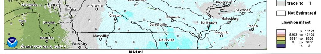
3 Rock Island District Saylorville Lake Lake Red Rock Coralville Lake
 1968 (Red Rock) 1977 (Saylorville)")


4 Reservoir Summary Began Operations in: 1958 (Coralville) 1968 (Red Rock) 1977 (Saylorville) Primary Authorized Purpose: Flood Risk Management on the Des Moines, Iowa, and Mississippi Rivers Other Authorized Purposes: Provide low flow augmentation, recreational opportunities, and natural resource management opportunities.
5 Storage Allocation Spillway Design Flood Surcharge Capacity Full Flood Control Pool 88.4 to 93.3% of Total Storage Volume Flood Control Storage Normal Conservation Pool (all year, except fall pool raise) 6.7 to 11.6% of Total Storage Volume Conservation Storage and Contracted Water Supply (Saylorville only)
6 Saylorville Water Supply Contract Contracted storage sold to the State of Iowa (1982). Sub-allocated to the Des Moines Water Works (2/3) and Alliant Energy (1/3). Provides for an undivided 18.86% of the usable storage between elevation 812 and 836 ft (projected to be 14,900 acre-ft after 25 years of sedimentation). Based on most recent survey, contracted storage is 12,300 acre-ft. State can order releases through outlet works or could construct facilities to directly withdraw from the lake.
7 Drought Management Integrated Component of the Water Control Manuals Drought schedule developed in coordination with State of Iowa Water supply has priority over water quality/conservation releases
8 Conservation Release Targets Saylorville Lake 200 cfs Coralville Lake 270 cfs 150 cfs Lake Red Rock 300 cfs
9 Drought Response Activities Level I II III IV Activity Monitor- stream flow, storage, rainfall, climate ***Normal Reservoir Operations*** Reduce release to base, activate CDMC, increase flow measurements, evaluate gate leakage and reservoir facilities, notify concession operators ***Actively Augmenting Releases*** Further reduction of release, increase CDMC meetings, activate IDMC, evaluate storage for emergency water needs ***Reduced Water Quality / Conservation Release with Full Water Supply Release*** Further reduction of release, allocate water for emergency needs, increase meetings of IDMC ***Water Supply Release Only***
10 Drought Index Levels Triggers Condition Today LEVEL Coralville Saylorville Red Rock I Always Always Always II Inflow < 150 Inflow < 200 Inflow < 300 III Pool < 678 Pool < 827 Pool < 734 IV Pool < 677 Pool < Pool < 730
11 Hedging Rules for Saylorville Reservoir II III IV Condition Recommended Reservoir Release Pool elevation > 827 Release all water supply and water quality demands. 826 < Pool Elevation < 827 Release 100 percent of water supply, maintain 175 cfs at dam, and 245 cfs at SE 14th Street. 825 < Pool Elevation < 826 Release 100 percent of water supply, maintain 150 cfs at dam, and 220 cfs at SE 14th Street. 824 < Pool Elevation < 825 Release 100 percent of water supply, maintain 125 cfs at dam, and 195 cfs at SE 14th Street < Pool Elevation < 824 Release 100 percent of water supply; maintain 100 cfs at dam, and 170 cfs at SE 14th Street. 819 < Pool Elevation < Release 100 percent of water supply; no water quality releases made. 816 < Pool Elevation < 819 Release 75 percent of water supply; no water quality releases made. Pool Elevation < 816 Release 50 percent of water supply; no water quality releases made.
12 Deviation Directive In response to low-water on the Mississippi River, directed to deviate from the water control plan to store additional water (up to 10% of flood storage) to be used for future augmentation of Mississippi River flows to support navigation. Due to low inflows at all projects, no significant storage was possible. Did not impact water available for conservation releases. Directive suspended prior to flood season.
13 Elevation (feet) Saylorville Pool Saylorville Outflow F low (cfs) Saylorville Inflow -200 Aug Sep Oct Nov Dec Jan Feb Mar
14 Elevation (feet) Red Rock Pool ,500 2,000 Red Rock Outflow F low (cfs) 1,500 Red Rock Inflow 1, Aug Sep Oct Nov Dec Jan Feb Mar
15 684.5 Coralville Pool Elevation (feet) ,800 1,600 F low (cfs) 1,400 1,200 1, Coralville Inflow Coralville Outflow Aug Sep Oct Nov Dec Jan Feb Mar
16 Drought Management Measures Deviations from Hedging Rules Deviation to Retain Fall Pool Raise or Minimal Pool Raise Recommend maintaining any pool rise due to precipitation, NTE 0.5 ft above conservation pool Long Term - No Spring drawdown of Coralville? Reduction in Outflows prior to Trigger Point Sale of Water for Consumptive Use Requires State Emergency Declaration Approval level depends on amount: < 100 Acre-ft - District Acre-ft - Division ASA (CW) Historical Perspective No requests
17 The target releases are not prescriptive, but rather intended as general guidance in setting reservoir releases. The releases are subject to revision during any particular drought event should a different response prove more beneficial. Recognize need to coordinate departures from Drought Contingency Plan hedging rules with State of Iowa. BLUF for Winter 2012/2013 Scenario Analysis and climate conditions indicated no major changes to current water management operations were needed.
18 Saylorville Elev (ft) Jan Mar May Jul Sep SAYLORVILLE-POOL 1974 FLOW-0 ELEV SAYLORVILLE-POOL 1976 FLOWS0 ELEV SAYLORVILLE-POOL 1989 FLOW-0 ELEV SAYLORVILLE-POOL 1999 FLOW-0 ELEV SAYLORVILLE-POOL 2003 FLOW-0 ELEV
19 Saylorville Reasonable Worst Case Elev (ft) Flow (cfs) Dec Jan Feb Mar Apr May SAYLORVILLE-POOL WORSE CASE0 ELEV CP2 WORSE CASE0 FLOW CP1 WORSE CASE0 FLOW Note: late April cut to 90 cfs plan calls for 0 cfs water quality release.
20 Red Rock Worst Case Elev (ft) Flow (cfs) Jan Mar May Jul Sep RED ROCK-POOL WORSE CASE0 ELEV CP1 WORSE CASE0 FLOW CP2 WORSE CASE0 FLOW
21 Coralville Worst Case Elev (ft) Flow (cfs) Dec Jan Feb Mar Apr CORALVILLE-POOL WORSE CASE0 ELEV CP3 WORSE CASE0 FLOW CP4 WORSE CASE0 FLOW
22 Identification of Water Users and Potential Impacts Users Identified from: Historical reports Existing knowledge/relationships Iowa DNR withdrawal permits Users contacted to determine: Nature of constraint (flow, stage, etc.) Critical Threshold Nature of Impact Possible River Alternatives Current actions or condition (are needs being met)

23 Downstream Water Users
24 Identification of Water Users and Potential Impacts Users Identified from: Historical reports Existing knowledge/relationships Iowa DNR withdrawal permits Users contacted to determine: Nature of constraint (flow, stage, etc.) Critical Threshold Nature of Impact Possible River Alternatives Current actions or condition (are needs being met)
25 865 Saylorville Elev (ft) Jan Mar May Jul Sep SAYLORVILLE-POOL 1974 FLOW-0 ELEV SAYLORVILLE-POOL 1976 FLOWS0 ELEV SAYLORVILLE-POOL 1989 FLOW-0 ELEV SAYLORVILLE-POOL 1999 FLOW-0 ELEV SAYLORVILLE-POOL 2003 FLOW-0 ELEV
26 834 Saylorville Lake Observed Worst Case / Inflow Recession Trigger for reducing outflow
27 Pool Recovery Winters of 1988/1989 and 1989/ days days Storage between and ~ 15,000 cfs-days (~ 0.1 of runoff from 5,823 sq. mi. basin)

28 BUILDING STRONG

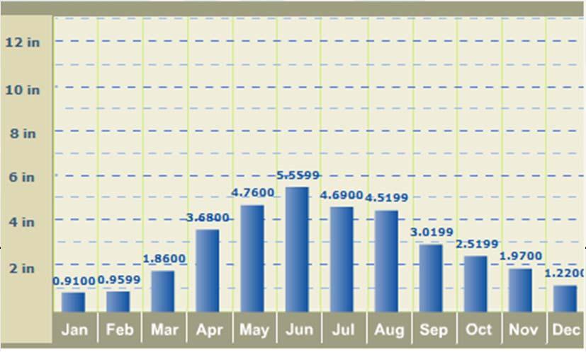
29 Monthly rainfall distribution for Fort Dodge, IA BUILDING STRONG

30 For More Information: Kevin Landwehr, P.E., D.WRE Chief, Hydrology and Hydraulics Branch Rock Island District, USACE