DEPARTMENT OF THE ARMY JACKSONVILLE DISTRICT CORPS OF ENGINEERS 1520 ROYAL PALM SQUARE BLVD. SUITE 310 FORT MYERS, FL
|
|
|
- Teresa Lyons
- 5 years ago
- Views:
Transcription

1 DEPARTMENT OF THE ARMY JACKSONVILLE DISTRICT CORPS OF ENGINEERS 1520 ROYAL PALM SQUARE BLVD. SUITE 310 FORT MYERS, FL REPLY TO Regulatory Division West Branch Fort Myers Permits Section October 5, 2018 PUBLIC NOTICE Permit Application No. SAJ (SP-ACM) TO WHOM IT MAY CONCERN: The Jacksonville District of the U.S. Army Corps of Engineers (Corps) has received an application for a Department of the Army permit pursuant to Section 404 of the Clean Water Act (33 U.S.C. 1344) as described below: APPLICANT: Habitat for Humanity WATERWAY AND LOCATION: The project would affect waters of the United States associated with Collier Seminole State Park, within the Rock Creek, Naples Bay region. The project site is located at Majestic Circle, Section 12, Township 51 S, Range 26E, Naples,. Directions to the site are as follows: From I75, exit 10 County Rd. 951 toward Naples/Marco Island. Turn south onto CR 951. After 6.8 miles, turn southeast onto US 41. After 3.4 miles turn left onto Greenway Blvd. After 0.9 miles turn left onto Majestic Circle. The property is located west of the existing Regal Acres Development. APPROXIMATE CENTRAL COORDINATES: Latitude Longitude PROJECT PURPOSE: Basic: Housing Overall: Low income residential development in south Collier County EXISTING CONDITIONS: The project site is acres. The wetland system consists of a 6.74 freshwater system and 3.88 acres of upland that will be impacted. The onsite vegetation is described in the Vegetation association and acreage below. The surrounding area is developed residential land.

2 PROPOSED WORK: The applicant seeks authorization to fill 4.13 acres of disturbed wet prairie and 0.69 acres of swale/ditch and retain 1.92 acres of wetlands in one 5.80 acre preserve area onsite. AVOIDANCE AND MINIMIZATION INFORMATION The applicant has provided the following information in support of efforts to avoid and/or minimize impacts to the aquatic environment: Due to the configuration of the wetlands onsite, wetland impacts are unavoidable for development of a feasible site plan. COMPENSATORY MITIGATION The applicant has offered the following compensatory mitigation plan to offset unavoidable functional loss to the aquatic environment: Based on a UMAM analysis of the wetlands onsite, the unavoidable impacts to 4.13 acres of wet prairie will result in the loss of 1.77 functional units. Compensation for the impacts include the purchase of 1.77 wetland credits from Panther Island Mitigation Bank. Onsite mitigation is not being sought for this work. CULTURAL RESOURCES: The Corps is not aware of any known historic properties within the permit area. By copy of this public notice, the Corps is providing information for review. Our final determination relative to historic resource impacts is subject to review by and 2
3 coordination with the State Historic Preservation Officer and those federally recognized tribes with concerns in Florida and the Permit Area. ENDANGERED SPECIES: The Corps has determined the proposed project may affect, but is not likely to adversely affect the Eastern Indigo Snake (Drymarchon couperi), Florida Panther (Felis concolor coryi), Red-cockaded Woodpecker (Picoides borealis), and Florida Bonneted Bat (Eumops floridanus). The Corps will request U.S. Fish and Wildlife concurrence with this determination pursuant to Section 7 of the Endangered Species Act. The Corps has determined the proposal would have no effect on the Florida scrub jay (Aphelocoma coerulescens). ESSENTIAL FISH HABITAT (EFH): This project is above Mean High Water and does not affect any EFH.Therefore, no consultation is required. NOTE: This public notice is being issued based on information furnished by the applicant. This information has not been verified or evaluated to ensure compliance with laws and regulation governing the regulatory program. The jurisdictional line has not been verified by Corps personnel. AUTHORIZATION FROM OTHER AGENCIES: Water Quality Certification may be required from the Florida Department of Environmental Protection and/or one of the state Water Management Districts. COMMENTS regarding the potential authorization of the work proposed should be submitted in writing to the attention of the District Engineer through the Fort Myers Permits Section, 1520 Royal Palm Square Blvd. Suite 310, Fort Myers, FL ; within 21 days from the date of this notice. The decision whether to issue or deny this permit application will be based on the information received from this public notice and the evaluation of the probable impact to the associated wetlands. This is based on an analysis of the applicant's avoidance and minimization efforts for the project, as well as the compensatory mitigation proposed. QUESTIONS concerning this application should be directed to the project manager, Allison Murphy, in writing at the Fort Myers Permits Section, 1520 Royal Palm Square Blvd. Suite 310,Fort Myers, FL ; by electronic mail at Allison.C.Murphy@usace.army.mil; by facsimile transmission at (239) ; or, by telephone at (239) IMPACT ON NATURAL RESOURCES: Coordination with U.S. Fish and Wildlife Service, Environmental Protection Agency (EPA), the National Marine Fisheries Services, and other Federal, State, and local agencies, environmental groups, and concerned citizens generally yields pertinent environmental information that is 3
4 instrumental in determining the impact the proposed action will have on the natural resources of the area. EVALUATION: The decision whether to issue a permit will be based on an evaluation of the probable impact including cumulative impacts of the proposed activity on the public interest. That decision will reflect the national concern for both protection and utilization of important resources. The benefits, which reasonably may be expected to accrue from the proposal, must be balanced against its reasonably foreseeable detriments. All factors which may be relevant to the proposal will be considered including cumulative impacts thereof; among these are conservation, economics, esthetics, general environmental concerns, wetlands, historical properties, fish and wildlife values, flood hazards, floodplain values, land use, navigation, shoreline erosion and accretion, recreation, water supply and conservation, water quality, energy needs, safety, food, and fiber production, mineral needs, considerations of property ownership, and in general, the needs and welfare of the people. Evaluation of the impact of the activity on the public interest will also include application of the guidelines promulgated by the Administrator, EPA, under authority of Section 404(b) of the Clean Water Act or the criteria established under authority of Section 102(a) of the Marine Protection Research and Sanctuaries Act of A permit will be granted unless its issuance is found to be contrary to the public interest. The US Army Corps of Engineers (Corps) is soliciting comments from the public; Federal, State, and local agencies and officials; Indian Tribes; and other Interested parties in order to consider and evaluate the impacts of this proposed activity. Any comments received will be considered by the Corps to determine whether to issue, modify, condition, or deny a permit for this proposal. To make this determination, comments are used to assess impacts to endangered species, historic properties, water quality, general environmental effects, and the other public interest factors listed above. Comments are also used to determine the need for a public hearing and to determine the overall public interest of the proposed activity. COASTAL ZONE MANAGEMENT CONSISTENCY: In Florida, the State approval constitutes compliance with the approved Coastal Zone Management Plan. In Puerto Rico, a Coastal Zone Management Consistency Concurrence is required from the Puerto Rico Planning Board. In the Virgin Islands, the Department of Planning and Natural Resources permit constitutes compliance with the Coastal Zone Management Plan. REQUEST FOR PUBLIC HEARING: Any person may request a public hearing. The request must be submitted in writing to the District Engineer within the designated comment period of the notice and must state the specific reasons for requesting the public hearing. 4

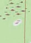
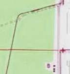
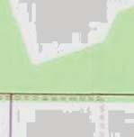
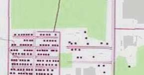
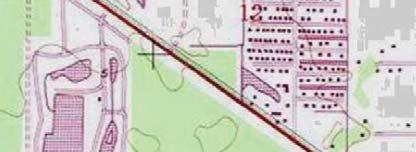
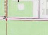
5 Tropical DR \\naps01\drawings\2017\ \environmental\usacoe & SFWMD permit drawings\locmap.mxd Date: 6/21/2018 Time: 4:07:14 PM User: pml TABLE OF CONTENTS Sheet Description 1 Location Map 2 USGS Quadrangle Map 3 Soils Map PENSACOLA 4 FLUCFCS Table & Notes 5 Existing Conditions 6 Proposed Conditions & Impacts 7 Photostation Locations 8 Typical Sections 951 SAN MARCO RD. table of contents.xlsx SEE STREET MAP AND VICINITY AERIAL AT RIGHT CHIPLEY PANAMA CITY TALLAHASSEE 1. These drawings are for permitting purposes only and are not intended for construction. 2. The aerial photographs shown were provided by Collier County property appraiser and were taken in COLLIER COUNTY N.T.S STATE OF FLORIDA Regal LAKE CITY GAINESVILLE TAMPA SARASOTA OCALA BARTOW FORT MYERS NAPLES SAINT AUGUSTINE ORLANDO DAYTONA BEACH Latitude: 26 2' 57" N Longitude: 81 39' 34" W Section: 12 Township: 51S Range: 26E FORT PIERCE WEST PALM BEACH FORT LAUDERDALE MIAMI Lanier CT Grapevine DR Sonoma BLVD Fern Lake CT Nautilus PL Windward LN Manchester DR Ocean Reef LN Lime Key LN Sugar Loaf LN STREET MAP N.T.S VICINITY AERIAL N.T.S Catamaran PL Topsail DR Majestic CIR Location Map Kingdom CT June N.T.S. 1 Emperor LN Greenway RD

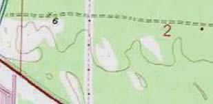
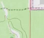
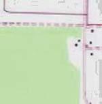
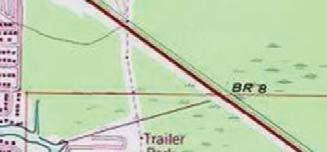
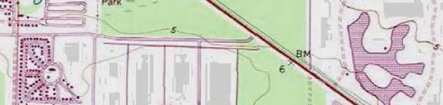
6 SCALE IN FEET \\naps01\drawings\2017\ \environmental\usacoe & SFWMD permit drawings\quad map.mxd Date: 6/21/2018 Time: 4:07:52 PM User: pml 1. The boundary shown is approximate. 2. USGS Quadrangle shown is BELLE MEADE SE (SW) 3. USGS Quadrangle Number is 1713 Copyright: 2013 National Geographic Society, i-cubed Regal USGS Quadrangle Map June As Shown 2


7 SCALE IN FEET LEGEND \\naps01\drawings\2017\ \environmental\usacoe & SFWMD permit drawings\soils map.mxd Date: 6/21/2018 Time: 4:00:35 PM User: pml The boundary shown is approximate. 2. Soils information shown was provided by Florida Geographic Data Library. 3. The aerial photographs shown were provided by Collier County and were taken in Soils polygon & map ID Hydric soils SOILS TABLE Map ID Description Hydric status Holopaw fine sand, limestone substratum Hydric 20 Ft. Drum and Malabar, high, fine sands Non-hydric 27 Holopaw Fine Sand Hydric \\naps01\drawings\2017\ \environmental\usa COE & SFWM D permit drawings\[soils table.xlsx]sheet1 Regal Soils Map June As Shown
8 \\naps01\drawings\2017\ \environmental\usacoe & SFWMD permit drawings\flucfcs table and notes.mxd Date: 6/21/2018 Time: 4:24:44 PM User: pml FLUCFCS Code Description Status Area (acres) Impact area (acres) 1. These drawings are intended for permitting purposes only and are not intended for construction. 2. The wetland and surface water lines shown have not been GPS located, have not been agency verified and are subject to change. 3. Nomenclature and delineations as per the Florida Land Use Cover and Forms Classification System (FLUCFCS) (FDOT, 1999). 4. Abbreviations N = Non-wetland SW = Surface Water W = Wetland Impacts, fill (cubic yards) Impacts, excavation (cubic yards) Preserve area (acres) 261E2 Abandoned agriculture, exotics 25-49% N E3 Abandoned agriculture, exotics 50-74% N E1 Palmetta prairie, exotics 1-24% N E2 Palmetta prairie, exotics 25-49% N E2 Hardwood - conifer mixed, exotics 25-49% N E3 Hardwood - conifer mixed, exotics 50-74% N Swale SW , E2 Wet prairie, exotics 25-49% W , E3 Wet prairie, exotics 50-74% W , Project Totals , Total Surface Waters (SW) Total Wetlands (W) Total Surface Water (SW) impacts Total Wetland (W) impacts Total Wetland (W) preserves Total Upland (N) preserves , ,978 \\naps01\drawings\2017\ \environmental\arcgis\shapefiles\[flucfcs_v3_preserve_impact.xlsx]flucfcs table Regal FLUCFCS Table & Notes June As Shown 4


 AREA IN ACRES (TYP.")


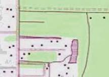
9 434E SCALE IN FEET \\naps01\drawings\2017\ \environmental\usacoe & SFWMD permit drawings\existing conditions.mxd Date: 6/21/2018 Time: 3:55:55 PM User: pml 643E3 434E2 643E3 434E ac ac. 321E2 643E2 434E2 643E2 321E1 434E2 261E ac. 261E3 WETLAND / SW ID (TYP.) AREA IN ACRES (TYP.) LEGEND 514 Project boundary FLUCFCS polygon & code Wetland / Surface Water systems 1. The aerial photograph shown was provided by Collier County government and was taken in December of See Sheet 4 for FLUCFCS Table and other notes. Regal Existing Conditions June As 2018 Shown 5
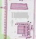
10 \\naps01\drawings\2017\ \environmental\usacoe & SFWMD permit drawings\proposed conditions.mxd Date: 6/21/2018 Time: 4:06:53 PM User: pml 0.99 ac. (PRESERVE) 0.93 ac. (PRESERVE) PROPOSED STORMWATER POND 0.94 ac. (IMPACT / FILL) 3.19 ac. (IMPACT / FILL) PROP OS ED RIGHT-OF-W AY PROPOSED RECREATION AREA PROPOSED LOT (TYPICAL) PROPOSED ENTRANCE FROM ADJACENT SUBDIVISION 0.69 ac. (IMPACT / FILL) LEGEND Project boundary Preserve boundary (5.80 ac.) SCALE IN FEET Wetland impacts (4.13 ac.; 41,978 cu. yds.) Surface water impacts (0.69 ac.; 7,013 cu. yds.) Wetland enhancement (1.92 ac.) Upland enhancement (3.88 ac.) Proposed site plan features 1. See Sheet 7 for Sections A-A and B-B. 2. See Sheet 4 for FLUCFCS Table and other notes. Regal Proposed Conditions & Impacts June As 2018 Shown 6
 0.93 ac. (PRESERVE) PROP OS ED RIGHT-OF-W AY PROPOSED RECREATION AREA PROPOSED LOT (TYPICAL) PROPOSED ENTRANCE FROM ADJACENT SUBDIVISION LEGEND Project boundary Preserve boundary (5.80 ac.")
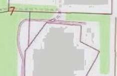
11 PROPOSED STORMWATER POND SCALE IN FEET \\naps01\drawings\2017\ \environmental\usacoe & SFWMD permit drawings\transect map.mxd Date: 6/21/2018 Time: 4:03:52 PM User: pml 0.99 ac. (PRESERVE) 0.93 ac. (PRESERVE) PROP OS ED RIGHT-OF-W AY PROPOSED RECREATION AREA PROPOSED LOT (TYPICAL) PROPOSED ENTRANCE FROM ADJACENT SUBDIVISION LEGEND Project boundary Preserve boundary (5.80 ac.) Wetland enhancement (1.92 ac.) Upland enhancement (3.88 ac.) Proposed site plan features Photo station 1. See Sheet 4 for FLUCFCS Table and other notes. Regal Photostation Locations June As Shown 7
12 PROPOSED PRESERVE (643E3) PROPOSED WETLAND FILL (643E3) PROPOSED GRADE TEMPORARY SILT FENCE (DURING CONSTRUCTION) NATURAL GROUND 3:1 MAX 10:1 3:1 MAX 4:1 MAX MIN. FFE 10.8' NAVD LEGEND PROPOSED WETLAND FILL TOTAL 4.13 ac.; 41,978 cu. yds. WETLAND FILL NATURAL GROUND SECTION A-A 1. See Sheet 6 for plan view showing section cut locations. 2. See Sheet 4 for other notes. TEMPORARY SILT FENCE (DURING CONSTRUCTION) NATURAL GROUND PROPERTY LINE 3:1 MAX 10:1 3:1 MAX 4:1 MAX MIN. FFE 10.8' NAVD PROPOSED GRADE NATURAL GROUND LEGEND PROPOSED SW FILL (514) PROPOSED SW FILL TOTAL 0.69 ac.; 7,013 cu. yds. SECTION B-B Regal Typical Sections