PUBLIC WORKS DEPARTMENT Council Meeting Date: November 15, 2011 Staff Report #:
|
|
|
- Franklin Rich
- 5 years ago
- Views:
Transcription
1 PUBLIC WORKS DEPARTMENT Council Meeting Date: November 15, 2011 Agenda Item #: F3 REGULAR BUSINESS: Authorize the City Manager to Amend the Agreement with Infrastructure Engineering Corporation to Complete Phase 3 of the Emergency Water Supply Project, by an Amount Not to Exceed $318,873 and Authorize Staff to Gather Additional Information to Evaluate the Feasibility of Easement Establishment or Purchase of Non-City Owned Tier 2 and Tier 3 Properties RECOMMENDATION Staff recommends that the City Council: 1. Authorize the City Manager to amend the agreement with Infrastructure Engineering Corporation to complete Phase 3 of the Emergency Water Supply Project, by an amount not to exceed $318,873 (budgeted funds) 2. Authorize staff to gather additional information to evaluate the feasibility of easement establishment or purchase of non-city owned Tier 2 and Tier 3 properties BACKGROUND The Menlo Park Municipal Water District (MPMWD) serves approximately 14,000 residents through two service areas; the eastern and western service areas, with approximately 3,000 service connections in the eastern service area and 1,000 service connections in the western service area. The area of the City between the western and eastern service areas is serviced by California Water Service (Cal Water). See Attachment A for a map of the MPMWD service area. MPMWD purchases 100% of its water from the San Francisco Public Utilities Commission (SFPUC), which pipes water to the peninsula area from the Hetch Hetchy reservoir in Yosemite National Park. Currently, MPMWD has two reservoirs in the western service area that provide storage for use in the event of an emergency, but the eastern service area does not have storage facilities, nor a dedicated secondary water supply that could be used in the event of a SFPUC service disruption. As a result, nearly 3,000 residents and businesses could be without water immediately for an undetermined period of time if earthquake or other disaster interrupts service from SFPUC. In order to address the need for an alternative supply in the eastern service area, the MPMWD has been pursuing the current emergency water supply project since The initially proposed project included a reservoir with an emergency well at Seminary Oaks Park, but after receiving input from nearby residents, the project was redirected to
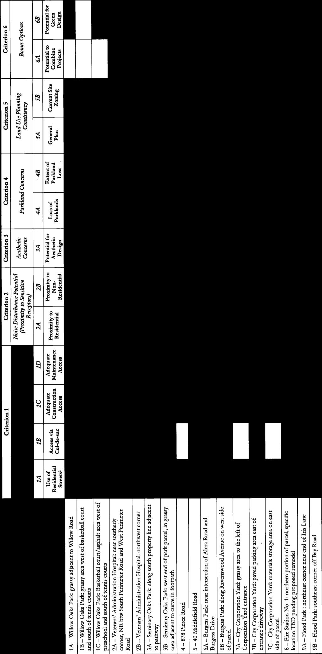
2 Page 2 of 9 a wells only approach that would place emergency well facilities at strategic locations within the eastern service area. In order to proceed with the wells only approach, the Council authorized staff to proceed with a wells siting study (October 2009) to determine how to best deliver at least 3,000 gallons per minute (gpm) of emergency water supply to the eastern service area. The 3,000 gpm goal approximates the amount of water that would be needed to meet the average day demand of approximately 1,600 gpm plus fire flow of 1,500 gpm. Based on this study, the required flow rate is expected to be achieved with the development of two to three productive wells. The proposed well facilities would be designed to house the wellhead, an emergency generator, water treatment facilities, and associated plumbing. It is anticipated that the facility would be approximately 1,500 square feet, however the actual size and configuration will be dependent on site conditions. Since most locations require a structure to secure the well, the architectural design will be evaluated for each specific site to ensure that the aesthetics of the proposed structure blends well with surrounding buildings. To determine the preferred well locations, staff recommended taking a three phase approach to site selection. Phase 1 would consist of determining the preliminary screening criteria for the proposed well sites; Phase 2 would consist of site specific evaluation and ranking criteria to select sites; and Phase 3 would consist of detailed engineering feasibility assessments to verify hydraulic capacity and preliminary site layout, following the completion of the first two phases. In October 2010, the Council approved the Phase 1, Preliminary Screening criteria and Phase 2, Site Evaluation and Ranking criteria as guidelines for staff to select sites. These criteria consisted of technical and hydrogeologic criteria, engineering feasibility criteria, and community livability criteria. Table 1, below, outlines the major technical, engineering and community criteria gathered as part of this process. Table 1 PHASE 1 PRELIMINARY SCREENING Technical and Hydrogeologic Criteria 1. Within or in close proximity to the water district s eastern service area to avoid the need for extensive additional infrastructure 2. Within the San Francisquito Cone, the subsurface alluvial deposit that contains the area s producing aquifers 3. Located ½ mile or greater from potential saltwater contamination, including the San Francisco Bay margin and salt evaporation ponds 4. Located where the San Francisquito Cone is thicker for best production 5. Located to limit interference with other existing wells.
3 Page 3 of 9 ANALYSIS Engineering Criteria Acquisition Feasibility Site Hydrogeology Construction Feasibility Operation &Maintenance Feasibility Regulatory Compliance Hydraulic Considerations Environmental Factors Construction Cost PHASE 2 SITE EVALUATION & RANKING RESULTS OF PHASE 1 PRELIMINARY SCREENING Community Criteria Site Access Noise Disturbance Potential Aesthetic Concerns Parkland Concerns Land Use Planning Consistency Utilizing the technical and hydrogeologic criteria set forth by the preliminary screening process, staff identified 15 potentially suitable locations offering 26 individual sites that could accommodate the new wells. The locations included five City-owned properties, six privately-owned properties, and four publicly owned properties (properties owned by government agencies outside of the City). Through the established process, non-city owned property would only be considered if the owner was open to sale or establishment of an easement to accommodate the project. Therefore, staff has made initial contact with each property to gauge interest in establishing an easement or selling land to the City. The result was the elimination of six of the 15 locations under initial consideration. Despite this reduction of potential sites, there were still nine locations with 17 potential well sites that would be considered for the project (See Attachment B for map). RESULTS OF PHASE 2 SITE EVALUATION AND RANKING Phase 2 used a combination of engineering, regulatory, environmental, and communitybased criteria to rank the nine locations (17 well sites) from Phase 1 and identify a short list of top-ranked sites that should be studied in detail. Staff anticipates that approximately two to three well sites will be needed to meet the 3,000 gpm goal, which would be verified through Phase 3 detailed studies. Site evaluation and ranking took place in three steps. 1. First, the remaining nine locations (17 well sites) were individually evaluated based on engineering and community criteria. The engineering evaluation was quantitative, with higher scores representing more favorable sites. The community factors evaluation was non-quantitative due to the subjective nature of the criteria evaluated. 2. Next, the engineering and community evaluations for each site were combined into an overall assessment. 3. Finally, the sites were ranked into four tiers shown below from Tier 1, representing the most overall desirable sites, to Tier 4, the sites to be less feasible (unfavorable from either the engineering or community perspective), and least likely to be used.

4 Page 4 of 9 The evaluation process was performed by staff and the City s consultant, Infrastructure Engineering Corporation (IEC) based on the Phase 2 criteria. A summary of the detailed scoring and evaluation for the Preliminary Site Ranking can be found in Attachment C. Figure 1, below, shows the Preliminary Well Site Ranking by tiers. All sites within each tier are considered to have equal rank, however only one site could be used from each location. (For example, Tier 1 has three potential well sites at the Corporation Yard; however, only one of these sites would be utilized for a well.) Figure 1 Tier 1 sites are deemed Most Desirable. These are the most appealing sites and are the current front-runners for well installation. Since all the sites are located at the City s Corporation Yard (Corp Yard) on Burgess Dr., only one of these sites would be used. Tier 2 sites are deemed Desirable. These sites have high potential for success, and because more than one well is anticipated, it is likely that at least of one of these sites may be used. Tier 2 sites are the VA Medical Center on Bay Road; a Cityowned vacant lot at 878 Pierce Road; a privately owned vacant site at 40 Middlefield Road; and the Menlo Park Fire District s (MPFD) Fire Station No. 1 on Middlefield Rd. Tier 3 sites are deemed Potentially Feasible. It is possible that one of these sites may be used in order to meet the goal of 3,000 gallons per minute. Tier 3 sites are Willow Oaks Park on Willow Rd., Burgess Park, Flood Park on Bay Rd., and the VA Medical Center on Willow Rd. Tier 4 sites are deemed Less Feasible. These sites would have even less
5 Page 5 of 9 likelihood of being used unless the goal of 3,000 gallons per minute cannot be met using Tier 1, Tier 2, and Tier 3 sites. Tier 4 sites are Willow Oaks Park on Willow Rd. and Seminary Oaks Park on Santa Monica Ave. Staff held two community meetings on August 29, 2011 and September 8, 2011 to present the Preliminary Well Site Rankings to the community and receive feedback on the preferred emergency well locations. Postcards announcing the meetings were mailed to all property owners and residents in the MPMWD service area east of El Camino Real and to property owners and residents within 750 feet of any potential well site location. In addition staff placed notices in The Almanac, sent out blasts to park user groups and project website subscribers, and updated the project website. Eight people attended the August meeting, which was held at the Arrillaga Family Recreation Center, and seventeen people attended the September meeting, which was held at the Senior Center in the Belle Haven neighborhood. In general, the attendees were supportive of using the Corp Yard and 878 Pierce Rd. since both are City-owned sites and do not impact parklands. In addition to this, the Corp Yard sites were appealing to most because the proposed well would be consistent with other uses at this location. 878 Pierce Rd. was considered especially attractive because it is the only site east of US-101; residents of the Belle Haven neighborhood were especially supportive of this location. The privately owned site at 40 Middlefield Rd. was also identified as desirable because of its currently vacant/blighted status and there was also general support for the MPFD Fire Station No. 1 site because a well would be a complimentary use and the site is already developed. Staff felt it necessary to get input from the residents surrounding the Corp Yard (as no one from these neighborhoods attended the Community Meetings) to determine which of the three potential well locations would be most desirable. Staff contacted and met with residents from the Burgess Classics neighborhood, located west of the Corp Yard. In general, the Burgess Classics residents felt that the Corp Yard already experiences a bottleneck of traffic, and that during an emergency, a well at that location would cause additional traffic problems if emergency vehicles or residents were routed to the well for fire water or drinking water. For this reason, the residents recommended utilizing a site that is located on an arterial route within the City. When discussing the specific locations at the Corp Yard, they felt that Site 7A was too close to their neighborhood and that eliminating the grassy area for this site was not favorable. They preferred either Site 7B or 7C because both would be hidden from view (see Figure 2). Staff also communicated with the apartment property owners adjacent to the Corp Yard about the proposed sites. The apartment property owners felt that Sites 7B and 7C were too close to their 2-story apartments and would add additional noise to the everyday Corp Yard maintenance noise their tenants already endure. They felt that the existing 6-foot wooden fence separating their properties from the Corp Yard was insufficient to block existing noise and they hoped the City could upgrade the fence to a sound wall if Site 7B or 7C was chosen for the well. RECOMMENDED SITE SELECTION Based on the Preliminary Site Ranking, and the information gathered from the community through the public outreach process, staff recommends the following sites for inclusion in the Phase 3 investigation.

6 Page 6 of 9 Tier 1 Corp Yard Site In response to the concerns of both the apartment property owners and the Burgess Classics owners, staff investigated alternative locations within the Corp Yard and has found one site in particular that appears to meet some of the needs of both groups. The 4 th well site is located just north of site 7A along the existing fenceline of the Corp Yard. This site would require the removal of some shrubs and realignment of the Corp Yard fence, but it would likely not require the removal of heritage trees or the grass landscape area. From an operational point of view, this location is in an area of the Corp Yard that is not heavily used and it is far enough away from underground obstacles (sewer/storm mains and laterals, gas tanks, etc.) to maintain the required 50- foot zone of control. In addition, by keeping the well facility inside the Corp Yard area, there is the potential to connect the new facility to the onsite emergency generator, which could significantly reduce the building footprint and cost of the facility. However, this option will need to be fully explored through the design process. The nearest resident would be approximately 135 feet from the wellhead. With these potential benefits, Staff believes that the 4 th Corp Yard site is the most feasible location for an emergency well and recommends it be included in the Phase 3 detailed engineering and hydrologic evaluations. Figure 2, below, shows an aerial view of the Corp Yard with the 4 th well site identified. Figure 2 Tier Pierce Road (City-Owned Property) Based on the Preliminary Site Ranking and community input, Staff recommends including the 878 Pierce Road site in the Phase 3 detailed engineering and hydrologic
7 Page 7 of 9 evaluations. This is the only City-owned property of the four Tier 2 sites and it is east of US-101. PHASE 3 DETAILED ENGINEERING AND HYDROLOGIC EVALUATIONS For the third phase of the project, staff recommends performing a detailed investigation at the above mentioned sites. In order to verify the availability of water at the various locations, the project geotechnical engineer will drill exploratory borings, extending from the surface into the deep aquifer, in order to establish the groundwater elevation and the hydraulic conductivity of the soil. This process is expected to take approximately 10 days and would occur during normal construction hours (not 24 hours/day). The City s noise ordinance limits construction noise emitted by power equipment to 85 decibels (dba) at all times. The noise level generated by a standard truck-mounted drilling equipment is on the order of 78 dba at a distance of 50 feet, and typical acceptable noise levels in residential areas are in the order of 60 dba. Staff anticipates using noise barriers to reduce the noise levels (about 10 dba at the source) so it is more acceptable to nearby residents. With the information gathered through this process, an expected flow rate at each site can be determined and it can be determined whether a third well site, and possibly a fourth, will be required. Prior to investigating the third and/or fourth site, staff will return to Council to present the findings of the top two well site candidates and request authorization for specific site investigation at the additional site(s), if necessary. In the event that a second Tier 2 site is needed to meet the 3,000 gpm goal, the remaining Tier 2 sites are: 1. The VA Medical Center off of Willow Rd Middlefield Road 3. The MPFD Fire Station No. 1 on Middlefield Rd. As these are not City-owned sites, the City would need to reach agreement with one of these properties for either sale or establishing an easement in order to construct a well. Staff has already made initial contact with these properties and is recommending that Council authorize staff to proceed forward and have further discussions with these properties to determine if either sale or establishing an easement would be feasible. If one of these properties is willing to sell or establish an easement with the City, staff will return to Council at a later date to present the findings and request authorization to drill an exploratory boring at that location. In the event that none of the property owners will work with the City, staff would then look to the Tier 3 locations for a third well site. The six potential well sites in Tier 3 are: 1. Willow Oaks Park off of Willow Rd. 2. The VA Medical Center northwest corner off of Bay Rd. 3. Burgess Park at the corner of Alma St./Burgess Dr. 4. Burgess Park adjacent to the library on Ravenswood Ave. 5. The northeast corner of Flood Park 6. The southeast corner of Flood Park off of Bay Rd.
8 Page 8 of 9 The Willow Oaks Park and Burgess Park sites are currently owned by the City and would not require easement or sales negotiations. If all of the Tier 2 site options have been exhausted and a Tier 3 site is needed, staff would return to Council at a later date for authorization to drill an exploratory boring at one of these sites. Following the completion of Phase 3 and the hydrologic determination of the proposed well sites, staff will return to Council to request authorization to begin the project s final design (Phase 4). This phase of the project will include CEQA review and preparation of construction documents. PROPOSED TIMELINE: Winter/Spring 2012 Spring 2012 Summer 2012 Fall 2012 Drill exploratory borings to determine viability City Council meeting to present exploratory drilling results for the Corp Yard and 878 Pierce Rd.; provide status of property negotiations with non-city-owned sites, if required; and request authorization for specific site investigation at additional site(s), if needed City Council meeting to seek authorization to proceed with final design and CEQA process for all proposed well sites City Council meeting to seek authorization to begin construction AMENDMENT TO INFRASTRUCTURE ENGINEERING CORPORATION (IEC) AGREEMENT In October 2006 the Council authorized a contract with Infrastructure Engineering Corporation (IEC) for preliminary design engineering services and outreach for a reservoir and supplemental water system project. In May 2010, IEC s scope of work was changed to identify and evaluate viable emergency well sites in and around the eastern service area with the goal to produce approximately 3,000 gpm of emergency groundwater. This agreement was for $165,966 and covered consultant activities for Phase 1 (Preliminary Screening) and Phase 2 (Site Evaluation and Ranking). Phases 1 and 2 are now completed, and all funds have been expended. In order to proceed with Phase 3 (Detailed Engineering and Hydrologic Evaluations), staff is recommending the Council authorize an amendment to IEC s agreement. The scope of work includes the Phase 3 hydrologic evaluation, preparing and submitting the CEQA Notice of Exemption, and performing exploratory drilling activities at the Corp Yard and 878 Pierce Rd. It also includes community outreach support, project management, and real estate acquisitions support (as needed), in an amount not-toexceed $318,873. IMPACT ON CITY RESOURCES Funds are available in the approved budget for the Emergency Water Supply Project.
9

10


11


12


13


14


15