PLANNING REPORT: Prepared for: Prepared by: PART LOT 27, CONCESSION 7 GEOGRAPHIC TOWNSHIP OF HOLLAND TOWNSHIP OF CHATSWORTH COUNTY OF GREY
|
|
|
- Arnold Webb
- 5 years ago
- Views:
Transcription
1 PLANNING REPORT: BUMSTEAD PIT Applications to Amend the County of Grey Official Plan and Chatsworth Zoning By-law to facilitate an Application for a Class A, Category 1 License for Mineral Resource Extraction PART LOT 27, CONCESSION 7 GEOGRAPHIC TOWNSHIP OF HOLLAND TOWNSHIP OF CHATSWORTH COUNTY OF GREY Prepared for: Brian and Pearl Bumstead Sideroad 60 Chatsworth, ON N0H 1R0 Prepared by: CUESTA PLANNING CONSULTANTS INC. 978 First Avenue West Owen Sound, ON N4K 4K5 Tel: Fax: cuesta@cuestaplanning.com September 2013 Revised November 2013
2 PLANNING REPORT Proposed Aggregate Extraction Operation Bumstead Pit Sideroad 60 Township of Chatsworth County of Grey Cuesta Planning Consultants Inc. September 2013 Revised November 2013
3 TABLE OF CONTENTS 1.0 Introduction Geographic Setting Description of Proposal Phasing Rehabilitation Resource Characteristics Overview Mineral Aggregate Resources Agrarian Resources Natural Heritage Resources Cultural Heritage Resources Surface and Groundwater Resources Land Use Considerations Overview Noise Land Use Policy Considerations Planning Act-Sections 2 and Provincial Policy Statement Grey County Official Plan Township of Chatsworth Zoning By-law Planning Summary... 24
4 Table of Contents cont. Table 1: Required Approvals... 1 Table 2: Natural Heritage Features... 5 Table 3: Planning Act, Section 2 Evaluation... 8 Table 4: Provincial Policy Statement-Consistency Analysis Figure 1: Site Location... 2 Figure 2: Geographic Setting... 3 Figure 3: Operations Plan... 3 Figure 4: Land Use Figure 5: Aggregate Resource Appendix 1 Minutes of August 28 th Meeting and Attendance Sheet
5 PLANNING REPORT Proposed Aggregate Extraction Operation Bumstead Pit Sideroad 60 Township of Chatsworth County of Grey 1.0 INTRODUCTION The following report has been prepared to address, in part, the complete application requirements of the Planning Act and Aggregate Resources Act regarding a Class A Category 1 Pit application submitted on behalf of Brian and Pearl Bumstead. The subject Planning Act and Aggregate Resources Act applications will be referred to as the Bumstead Pit for the purposes of this report. The Bumstead holding forms a 39.6 ha (97.85 ac.) property and is legally described as Part of Lot 27, Concession 7 in the Geographic Township of Holland, now part of the Township of Chatsworth, in the County of Grey. The lands are municipally described as Sideroad 60 in the Township of Chatsworth. The site is located at the northeast corner of the intersection of Sideroad 60 and Veterans Road South, approximately 4.5km southwest of the Hamlet of Berkeley. Provincial Highway 10 bisects the Berkeley Hamlet Area and provides the closest connection to the provincial highway system from the proposed pit. A location map is provided in Figure 1. As noted above, the following report is intended to satisfy the complete application requirements of the Planning Act and support the aggregate license application under the Aggregate Resources Act. A summary of the required approvals is provided in the table below: Table 1: Required Approvals Application County of Grey Official Plan Amendment to identify the subject lands as Mineral Resource Extraction on Schedule B. Township of Chatsworth Zoning By-law Amendment to re-zone the subject lands from (A1) Rural to (M3) Extractive Industrial Zone in order to permit aggregate extraction. Aggregate Resources Act (ARA) Category 1 License (Class A pit below the watertable) Approval Authority County of Grey Township of Chatsworth Ministry of Natural Resources (MNR) 1

6 Figure 1: Site Location A series of technical reports have been prepared to support the applications noted above. These technical reports have been referenced in the preparation of this Planning Report and the ARA Summary Statement and form part of this submission. For ease of reference, these technical reports and plans include the following: Natural Environment Level l & ll Technical Reports and Environmental Impact Assessment prepared by AET Consultants, April 24, 2013 Ministry of Culture Stage l and Stage ll Archaeological Assessment prepared by Dr. William Fitzgerald, June 21, 2012 Level l Hydrogeological Study prepared by Gamsby & Mannerow Ltd., September 2013 Road Assessment prepared by Gamsby & Mannerow Ltd., May 2013 Summary Statement prepared by Gamsby & Mannerow, September 2013, revised November 2013 Aggregate Resources Act Site Plans prepared by Gamsby & Mannerow Ltd., September 2013, revised Informal Public Meeting coordinated by Cuesta Planning Consultants, Inc., August 28 th, 2013, Minutes and Attendance (Appendix 1) 2

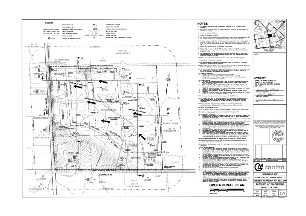
7 1.1 Geographic Setting As generally described above, the proposed Bumstead pit is located at the northeast corner of the intersection of Sideroad 60 and Veterans Road South in a rural area in the southern section of Chatsworth Township. The Hamlet of Berkeley, located approximately 4.5km northeast of the proposed pit is the closest settlement area. Sideroad 60 intersects with Highway 10 in the Hamlet of Berkeley and provides the most direct access from the site to the provincial highway network. In general, surrounding properties are rural in nature and are comprised of a mixture of farms and non-farm residential uses. The Bumstead lands include an existing farm residence, barn and outbuildings located in the southwest portion of the property, with access to Sideroad 60. The majority of the lands are currently used for mixed crop production with the balance of the remainder of the property being comprised of woodlands and the farm buildings noted above. Figure 2: Geographic Setting 1.2 Description of Proposal Figure 3 The Bumsteads intend to license the entirety of their 39.6 hectare property in order to permit a Class A Category 1 mineral resource extraction operation with extraction to the established high watertable. In total, a surface area of approximately 18.9 hectares is proposed for extraction. The remaining 20.7 hectares included in the proposed licensed area will be comprised of buffer lands, visual screening and environmental setbacks designed to minimize the impact of the proposed pit operation on surrounding land uses. The 18.9 hectares proposed for extraction are expected to yield approximately 1,675,000 tonnes of sand and gravel material. 3
8
9 The proposed Class A Category 1 license will permit the extraction of up to 150,000 tonnes annually to the depth of the established high watertable. The approximate depth of aggregate above the watertable is 4m. It is not anticipated that the operation would realize the annual extraction limit, however this limit will provide flexibility for the future operator of the proposed pit in the event of large public contracts. Based on the maximum rate of annual extraction, the proposed pit would have a lifetime of approximately 11 years. The lifetime of extraction however, will ultimately hinge on the demand for aggregate material from the Bumstead pit. 1.3 Phasing The Bumstead Pit is to be developed in three (3) phases with extraction commencing at the easterly portion of the licensed area and continuing westerly across the site. Each phase of the proposed extraction operation will include approximately one third of the total area designated for extraction. It is the intent of the phasing scheme is to permit a progressive rehabilitation process. A detailed overview of the specific works involved in each phase of the proposed pit operation is provided in the ARA Summary Statement and Operations Plan prepared by Gamsby & Mannerow. 1.4 Rehabilitation In accordance with the requirements of the Provincial Policy Statement, 2005 and the Aggregate Resources Act Provincial Standards, the proposed Bumstead Pit will be progressively rehabilitated back to an agricultural use thereby ensuring this portion of the Township remains in agriculture over the long term. The rehabilitation of the extracted lands will occur in a progressive manner, with the rehabilitation following the removal of the aggregate material as closely as is feasible. It is intended that each phase will be rehabilitated prior to the subsequent phase being extracted. Rehabilitation of the site to agricultural land of similar capability will involve the addition of 0.5 metres of clean fill across the site post-extraction, as well as the replacement of.4m of topsoil. Due to the proximity of the proposed extraction to the groundwater table, the additional fill is intended to ensure that proper drainage remains to support agricultural activities on the rehabilitated pit. A detailed overview of the rehabilitation scheme is provided in the Rehabilitation Plan and summarized in the ARA Summary Statement prepared by Gamsby & Mannerow. 2.0 RESOURCE CHARACTERISTICS 2.1 Overview The proposed pit is located in the Horseshoe Moraines physiographic region identified by Chapman and Putman in the Physiography of Southern Ontario, The geographic Township of Holland is generally covered by a complex mix of till ridges, kame moraines, outwash plains, and spillways, interspersed with more smoothly 4
10 moulded till plains and drumlinized areas. The farm buildings are located on a portion of a drumlin while the balance of the farm is on a portion of outwash plain. 2.2 Mineral Aggregate Resources Gamsby and Mannerow conducted a number of testholes on the subject property in order to determine the quality and quantity of the on-site aggregate resource. The Ontario Provincial Standards provide the highest industry standards in determining quality of aggregate and hence the most appropriate use of the resource. The on-site deposit was tested and determined to be a very high quality resource suitable for the construction industry, particularly within the Grey-Bruce region. 2.3 Agrarian Resources The majority of the subject property has been identified as containing soils classified as 3FM under the Canadian Land Inventory Index (CLI). A classification of 3FM would indicate soils which have moderate to severe limitations due to low natural fertility of the soil and a moisture deficiency in the soil. It is likely that, once rehabilitated, soil quality on the site may be an improvement of what currently exists on the site which should benefit any future agricultural operation. 2.4 Natural Heritage Resources The PPS and the Aggregate Resources Act both require the protection of Natural Heritage Resources. In order to determine if any of the seven significant natural heritage features, specified in the PPS, are located on, or adjacent to, the proposed Bumstead Pit, a Level l Natural Environment Study was conducted by AET Group. The results of this preliminary environmental investigation are summarized in the following table: Table 2: Natural Heritage Features Natural Heritage Feature Licensed Area Extraction Area Adjacent Lands (120 m radius) Provincially None None None Significant Wetlands Habitat of None None None Threatened or Endangered Species Fish Habitat None None None Significant Woodlands None None Identified by Polygons 1 in Figure 3 of AET NETR. Significant None None None Valleylands Significant Wildlife None None None Habitat Areas of Natural and Scientific Interest None None None 5
11 Due to the presence of Significant Woodlands in an area northwest of the proposed Bumstead Pit, a further Level ll Natural Environment Technical Study was completed. The aim of the Level ll study was to determine any potential impacts the proposed aggregate extraction could present with regard to the natural heritage features and determine any necessary mitigation measures to ensure these resources are protected. The Level ll study concluded that No significant, long term natural environment impacts affecting significant features or functions are expected. This is because the significant woodlands found in polygons 1, 9 and 10 will remain intact and will be protected by the separation from gravel pit activity by road allowances and operational setbacks with vegetated buffers. As well, the extraction will not actually go below the watertable. 2.5 Cultural Heritage Resources Dr. William Fitzgerald was retained by Cuesta Planning Consultants Inc. on behalf of the applicants, to complete an Archaeological Assessment on the subject lands as required by the PPS and ARA. Stage 1(Evaluation of Archaeological Potential) of the assessment revealed that certain criteria were met for the potential of archaeological resources to be found on the site. The criteria included proximity to a secondary water source, elevated topography, an area of early Euro-Canadian settlement and an area of early historic transportation routes. The existence of such potential automatically advances the assessment forward to a Stage 2 Assessment (Property Assessment) which includes field work. The on-site field investigation is intended to discover any cultural sites which may be deemed significant. Dr. Fitzgerald s site visit determined that the area intended for extraction did not contain any item of historical or archaeological significance and that the area with the most potential for Native and Euro-Canadian cultural activity includes only the existing homestead which is well away from the proposed extraction area. Site plan notes will be added to the ARA Operations Plan to ensure future compliance with the Ontario Heritage Act, the Cemeteries Act and the Funeral, Burial and Cremation Services Act. 2.6 Surface and Groundwater Resources The closest surface water feature to site is a pond/marsh feature on the neighbouring property to the east of the site. This feature is approximately 280 metres from the eastern property boundary of the subject proposal. An on-site groundwater spring also exists. The regional groundwater flow is generally in an east-southeast direction. A Level 1 Hydrogeological Study was conducted by Gamsby and Mannerow Limited for the proposed Bumstead Pit. The study included a review of the background data, including but not limited to Ministry of the Environment (MOE) well records, relevant mapping and the Grey and Bruce Counties Groundwater Study, as well as field investigations. The field investigations included reviewing the on-site and surrounding land uses, natural features, surface water features and topography of the area in addition to determining any connections to the groundwater regime. In addition, test pitting was conducted on the site to determine aggregate quality and estimates of quantity on the site. Monitoring wells were installed on the site to define water table elevations and the groundwater flow. As well, a survey was conducted on the site in order to provide the most accurate 6
12 elevation and spatial data for the site prior to the determination of appropriate extraction depths and limits. Gamsby and Mannerow determined that the high water table ranges from masl (west) to masl (east) on the site. The maximum depth of extraction is to the high water table. It was also determined that the operation will not impact the local water supply, surrounding wells or any surface water features, as no dewatering or water diversion is planned as part of the operation. A number of recommendations have been added to the operations plan of the Bumstead pit in order to provide additional levels of safety and mitigation with respect to potential surface and groundwater impacts. These include; Refueling and maintenance of machinery (if any) should not be conducted in areas of the excavation which are within 1.5 m of the watertable, i.e., where excavations are completed to the watertable Excavation and/or operation of vehicles should not be conducted in areas of standing or ponded water Excavation shall not proceed past the depth where water enters the excavation. Once water enters an excavation area, the water level elevation should be noted and adjacent excavations stopped approximately 0.3 m above the water level elevation No chemical spraying (pesticide/herbicide) should be conducted in areas of the excavation An access/egress route/road should be maintained greater than 1.0 m above the maximum proposed depth in the excavation areas (to prevent vehicle operation in areas of standing water) Areas should maintain vegetative cover as long as possible prior to excavation No dewatering or re-direction of surface water outside of the pit should be conducted to augment aggregate extraction During operations, areas of standing water should be noted and recorded on a weekly basis. Where areas of standing water are noted to remain for a period of greater than one-month during operational periods and are associated with the groundwater elevation (as opposed to surface pooling), remediation by filling with suitable soils is to be conducted. 3.0 LAND USE CONSIDERATIONS 3.1 Overview The proposed Bumstead Pit is located in a rural area of Chatsworth Township, dominated by agricultural operations. The surrounding area also includes several nonfarm residential uses located primarily along Veterans Road South and 60 Sideroad. The Berkeley Hamlet Area is located approximately 4.5 kilometres east of the proposed pit and includes a mix of residential and convenience commercial uses. In order to provide the community with an opportunity to provide some initial input, an informal public meeting was held at the Williamsford Community Centre on August 28 th, 7
13 2013. Approximately 16 people attended. The minutes of that meeting are attached as Appendix 1 of this report. 3.2 Noise The Provincial Standards for a Class A Category 1 pit license requires a noise study to be conducted if extraction is proposed to occur within 150 metres of a sensitive receptor. In this regard, the limit of extraction has been reduced so as to provide a 150 metre noise buffer from all residential dwellings located along Veterans Road and minimize any potential noise impacts in accordance with Provincial Standards. In addition, the construction of berms between the extraction operation and adjacent residences, as outlined on the Operations Plan, will provide further mitigation of noise associated with the proposed extraction. No processing of aggregate material will occur within 300 metres of any sensitive receptor. Given the foregoing, it is not anticipated the proposed pit will present unacceptable noise impacts to adjacent residents. 4.0 LAND USE POLICY CONSIDERATIONS The protection and management of aggregate resources has been deemed to be of provincial significance and their development is regulated by specific legislation. In addition to the Aggregate Resources Act (ARA), the development of aggregate extraction operations must respect the provisions of the Planning Act and give appropriate consideration to the policy framework established by the regional and municipal planning documents. 4.1 Planning Act- Sections 2 & 3 When carrying out its responsibilities under the Planning Act, a municipality or any other authority which affects a planning matter must have regard for the provincial interests as identified in Section 2 of the Planning Act. The provincial interests contained in Section 2 of the Planning Act are outlined in the table below. The Bumstead proposal has been evaluated in the context of these prescribed provincial interests: Table 3: Planning Act, Section 2 Evaluation Provincial Interests The protection of ecological systems, including natural areas, features and functions. Bumstead Application The only natural feature possessing ecological significance, as defined by the PPS, is a cluster of woodlands located on adjacent properties northwest of the site. These significant woodlands are identified on Figure 3 of the Natural Environment Technical Report prepared by AET Consultants and submitted in support of the Bumstead applications. The Bumstead proposal has regard for the protection of this Natural Heritage feature as follows: 8
14 This woodland feature has previously been compromised by non-farm residential development. The existing significant woodlands are separated from gravel pit activity by existing road allowances and will remain intact. Further operational setbacks and vegetated buffers have been included on the ARA Site Plans which will, among other matters, ensure no impact on this adjacent feature. The protection of the agricultural resources of the province. The conservation and management of natural resources and the mineral resource base. The conservation of features of significant architectural The supply, efficient use and conservation As provided by a review of the Canada Land Inventory, the Bumstead property is comprised of Class 3FM soils. Class 3FM soils are considered to have, moderately severe limitations that restrict the range of crops or require special conservation practices. In accordance with the Provincial Policy Statement, the pit will be rehabilitated so that substantially the same areas and same average soil quality for agriculture are restored post-extraction. It could be anticipated that the soil quality post-extraction may actually be higher than what is currently on site. The rehabilitation plan prepared by Gamsby & Mannerow (G & M) is enforceable under the provisions of the ARA and provides the appropriate mechanism to ensure this rehabilitation occurs. Aggregate resources are a provincial interest and should be protected from incompatible land uses and developed responsibly. The proposed pit will provide a high quality supply of mineral aggregate material to the local and regional markets. No significant natural heritage features will be impacted by the pit operation and the agricultural use will be restored progressively as the site is extracted. No significant heritage features have been identified on the site or adjacent lands. Ground and surface water features have 9
15 of energy and water The adequate provision and efficient use of communication, transportation, sewage and water services and waste management systems. The orderly development of safe and healthy communities. The adequate provision and distribution of educational, health, social cultural and recreational facilities. been studied and documented. Extraction will not occur below the established groundwater table and will not impact the existing pattern of surface water movement. Mitigation measures included on the Operations Plan such as, groundwater level monitoring and restriction of surface activities will minimize the potential for groundwater disturbance or contamination in accordance with provincial guidelines. The only provincial interest of relevance to the Bumstead proposal is the transportation systems. Trucks from the proposed pit will travel east on Sideroad 60 before connecting to Provincial Highway 10. The roads assessment prepared by G & M demonstrates the appropriateness of surface and subsurface conditions on the proposed haul route to accommodate the increase in traffic to be realized during operation of the Bumstead pit. The assessment directed that load capacity should be limited during spring and fall in order to prolong the lifespan of the road. Through further consultation with Chatsworth Township, the applicants may be amenable to providing some limited long term maintenance provisions if required on Sideroad 60 by the Township. To address safety concerns on a portion of Sideroad 60, a restriction on speed limits could be implemented. The proposed pit will provide a close to market supply of mineral aggregates. Aggregate material is an essential resource in the orderly development of communities. The rehabilitation plan will ensure the long-term protection of farmland. The proposed pit will not increase the demand for these services but will contribute financially to their continuation. 10
16 The adequate provision of employment opportunities. The protection of the financial and economic well-being of the Province and its municipalities. The coordination of planning activities of public bodies. The resolution of planning conflicts involving public and private interests. The protection of public health and safety. The proposed aggregate extraction operation will result in the creation of longterm employment opportunities in the Township of Chatsworth. These primary resource jobs present a multiplier effect which can result in the creation of additional supplemental service jobs in the Township. In addition to the employment opportunities created by the proposed operation, the Township will see an increase in revenue through increased assessment and annual tonnage contributions as well as an additional source of aggregate to contribute to competition in the market. The interests of public bodies and agencies are considered by the circulation requirements of the Planning Act and the ARA. The land use planning process, as well as the ARA licensing process, enables municipalities, agencies and the public to participate in the evaluation of this proposal. When conflicts arise, various mediation methods are available to resolve issues. Further, the Ontario Municipal Board is available to resolve land use disputes. An informal meeting with neighbouring property owners was also held as part of this planning process in order to address any reasonable concerns of neighbours prior to submission of the application to the approval authorities. The minutes of this meeting are attached as Appendix 1. The operational plan prepared by G & M contains a variety of mitigation measures intended to maintain public health and safety standards in accordance with various provincial regulations. Further mitigation measures have been developed to minimize the social impact of the proposed pit operation. The requirements of the Operation Plan and site plan notes therein are legally binding as per the ARA. 11
17 The appropriate location of growth and development. Rural areas are prime location for the development of this fixed resource. The subject lands contain a primary and tertiary aggregate deposit identified on Schedule B of the Grey County Official Plan. Onsite investigation has confirmed the quality and extent of this resource. No significant natural or cultural heritage features will be impacted by the proposed pit operation. The roads assessment prepared by G & M demonstrates the suitability of Sideroad 60 to service the proposed development. 4.2 Provincial Policy Statement (PPS) 2005 The Minister of Municipal Affairs and Housing, under Section 3 of the Planning Act, can issue policy statements that provide direction to other ministries, municipalities and agencies on matters of provincial interest as they relate to land use planning. These policy statements are developed in consultation with other ministries and are updated from time to time. The latest PPS came into effect on March 1 st, 2005 and any land use decision by any authority that affects a planning matter must be consistent with the PPS. It is appreciated that one must consider the PPS in its entirety and apply the relevant policies to a particular situation. Although it is appreciated that the policies of the PPS must be considered in their entirety, the most applicable policies with regard to the proposed Bumstead pit are outlined in Section 2, the Wise Use and Management of Resources. The provincial interests that have the most relevance to this proposal and to which the proposal must be consistent, relate to; The wise use and management of aggregate resources, maintained as close to markets as possible, for the long-term economic, social and environmental benefit of the Province and its municipalities; and Prime agricultural areas shall be protected for long term use for agriculture with specialty crop areas given the highest priority The Bumstead property contains two resources which are of provincial significance, a high quality aggregate resource and a certain amount of prime agricultural land. The progressive rehabilitation plan, associated with the proposed aggregate extraction operation, can satisfactorily address the balance required to manage these competing provincial interests. The following table provides an evaluation of the Bumstead proposal in the context of the relevant policies of the PPS. The evaluation is based largely on findings of various technical studies referenced previously in Section 1.0 of this report. 12
18 Table 4: Provincial Policy Statement Consistency Analysis PPS Policies Healthy, liveable and safe communities are sustained by: a) promoting efficient development and land use patterns which sustain the financial well-being of the Province and municipalities over the long term; Analysis The proposed Bumstead Pit will provide a close-to-market supply of aggregate material for central Grey County. Close-tomarket aggregate extraction provides a cost-effective source of this resource for municipalities in carrying out essential infrastructure projects. Ensuring the availability of close-to-market supply of aggregate resource is in the financial interest of area municipalities. The use of existing transportation infrastructure also promotes efficient development c) c) avoiding development and land use patterns which may cause environmental or public health and safety concerns; In rural areas located in municipalities: permitted uses and activities shall relate to the management or use of resources, resource-based recreational activities, limited residential development and other rural land uses; Efficient use shall be made of existing and planned infrastructure. The various technical reports prepared in support of the Bumstead applications demonstrate that the proposed pit development will not affect any significant natural heritage feature or ground and surface water. The adherence to provincial standards for noise and dust assures appropriate safeguards to protect public health and safety. The annual tonnage contribution received by the Township as a result of the pit operation will ensure that funds are available for road maintenance and upgrades during the lifespan of the extraction operation. The proposed Bumstead pit relates to the use and management of a provincially significant natural resource and represents appropriate rural land use. Truck traffic from the proposed Bumstead pit will utilize a portion of Sideroad 60 in order to access the Provincial Highway network. The Ontario Aggregate Resource Corporation (TOARC) will distribute to the 13
19 Township, the annual contributions received from the tonneage levy from the proposed pit which will help ensure the sustained maintenance of the haul road throughout the duration of the pit operation. The proposed pit will not require any extension or expansion of municipal infrastructure Long-term economic prosperity should be supported by: a) optimizing the long-term availability and use of land, resources, infrastructure and public service facilities; The proposed Bumstead pit will increase the availability of close-to-market supplies of aggregate resources in this area of Grey County. The progressive rehabilitation plan ensures that the long-term agricultural use of the subject lands is protected. g) promoting the sustainability of the agrifood sector by protecting agricultural resources and minimizing land use conflicts; and Natural features and areas shall be protected for the long term Planning authorities shall protect, improve or restore the quality and quantity of water by: using the watershed as the ecologically meaningful scale for planning; minimizing potential negative impacts, including cross-jurisdictional and crosswatershed impacts; identifying surface water features, ground water features, hydrologic functions and natural heritage features and areas which are necessary for the ecological and hydrological integrity of the watershed; The only natural feature of any significance located in proximity to the proposed Bumstead pit is a wooded area adjacent to the western boundary of Veterans Road South. This significant woodland and its ecological function are protected by operational setbacks and separated from extraction activity by existing road allowances. All significant woodlands on adjacent properties will remain intact and will not be affected by the proposed pit. No surface water features, hydrolic natural heritage features or municipal drinking water sources are located on or within 120 metres of the Bumstead property. The proposal will ensure the preservation of existing groundwater quality and quantity by retaining a buffer between the pit floor and the established high water table. Should groundwater be encountered, the water level is to be noted and excavation is to be stopped in adjacent areas at 0.3 metres above the waterlevel elevation. Standing water will be noted and recorded with remediation to occur in the form of filling with suitable soils, should the standing water occur for over a month and be associated with groundwater elevation 14
20 implementing necessary restrictions on development and site alteration to: 1. protect all municipal drinking water supplies and designated vulnerable areas; and 2. protect, improve or restore vulnerable surface and ground water, sensitive surface water features and sensitive ground water features, and their hydrologic functions; maintaining linkages and related functions among surface water features, ground water features, hydrologic functions and natural heritage features and areas; (as opposed to surface pooling). Vegetation cover will be restored to current levels through the progressive rehabilitation process. Several operational best practices have been included on the Operations Plan in order to minimize any potential for surface activities to impact groundwater quality. These include groundwater level monitoring and restriction of surface activities in accordance with provincial guidelines. Further, contingency measures have been implemented on the site plans in order to provide for appropriate corrective actions should groundwater be encountered during extraction. promoting efficient and sustainable use of water resources, including practices for water conservation and sustaining water quality; and ensuring stormwater management practices minimize stormwater volumes and contaminant loads, and maintain or increase the extent of vegetative and pervious surfaces Prime agricultural areas shall be protected for long-term use for agriculture. Prime agricultural areas are areas where prime agricultural lands predominate. Specialty crop areas shall be given the highest priority for protection, followed by Classes 1, 2 and 3 soils, in this order of priority As much of the mineral aggregate resources as is realistically possible shall be made available as close to markets as possible. Demonstration of need for mineral aggregate resources, including any type of supply/demand analysis, shall not be required, notwithstanding the availability, designation or licensing for extraction of mineral aggregate resources locally or The rehabilitation plan submitted as part of proposed pit license ensures that substantially the same areas and same average soil quality for agricultural use will be restored progressively as extraction occurs and that the Bumstead property will be protected for mixed crop production over the long-term. The proposed pit will provide a significant supply of commercially viable aggregate material for the local and regional market. The proposed pit will increase access to close-to-market supply of aggregates in central Grey County. 15
21 elsewhere Extraction shall be undertaken in a manner which minimizes social and environmental impacts The conservation of mineral aggregate resources should be promoted by making provision for the recovery of these resources, wherever feasible Progressive and final rehabilitation shall be required to accommodate subsequent land uses, to promote land use compatibility, and to recognize the interim nature of extraction. Final rehabilitation shall take surrounding land use and approved land use designations into consideration On these prime agricultural lands, complete agricultural rehabilitation is not required if: The technical studies prepared in support of the proposed Bumstead pit demonstrate that no natural or cultural heritage features will be impacted by the development. The hydrogeological study has confirmed groundwater elevations and the site plans ensure that extraction will occur to the high water table only. Protection of the groundwater feature will be mainly through use of a 0.3 metre buffer if and when water enters the excavation. A series of operational practices designed to restrict activities which could present threats to groundwater have been included on the operations plan. Adherence to provincial standards for noise and dust will minimize any potential social impacts and nuisances. The TOARC contributions will provide a sustained fund to the Township for road maintenance along the proposed haul route and ensure safe vehicular access to and from the site is provided over the long-term with minimal disruption to existing traffic flows. The proposed Bumstead pit provides an opportunity for the recovery of aggregate resources where it has been demonstrated that no unacceptable environmental or social impacts will occur. As described previously in this report, the Bumstead pit will be progressively rehabilitated to substantially the same soil quality for agriculture. The restoration of this property to agricultural use will complement the agricultural nature of the surrounding area. The proposed Bumstead pit will be progressively rehabilitated to substantially the same area and average soil quality in order to provide for and protect the site s long term agricultural use. there is a substantial quantity of mineral aggregate resources below the water table 16
22 warranting extraction, or the depth of planned extraction in a quarry makes restoration of pre-extraction agricultural capability unfeasible; other alternatives have been considered by the applicant and found unsuitable. The consideration of other alternatives shall include resources in areas of Canada Land Inventory Class 4 to 7 soils, resources on lands identified as designated growth areas, and resources on prime agricultural lands where rehabilitation is feasible. Where no other alternatives are found, prime agricultural lands shall be protected in this order of priority: specialty crop areas, Canada Land Inventory Classes 1, 2 and 3; and agricultural rehabilitation in remaining areas is maximized Development and site alteration shall only be permitted on lands containing archaeological resources or areas of archaeological potential if the significant archaeological resources have been conserved by removal and documentation, or by preservation on site. Where significant archaeological resources must be preserved on site, only development and site alteration which maintain the heritage integrity of the site may be permitted. A Stage l & ll Archeological Assessment was completed by Dr. William Fitzgerald and accepted by the Ministry of Tourism, Culture and Sport. As part of the Stage ll assessment, on-site subsurface investigation was conducted across the area of proposed extraction. In general, the Stage ll assessment found no evidence of archaeological features and concluded that the proposed area of extraction, be considered free from further archaeological concern. The assessment demonstrates the absence of significant archaeological resources and ensures conformity with the PPS in this regard. 4.3 Grey County Official Plan All land within the Township of Chatsworth is subject to the provisions of the Grey County Official Plan. The Bumstead property is currently designated as Agricultural on Schedule A Land Use of the Grey County Official Plan (Figure 4). Also, it is important to note that the easterly portion (approximately 35% of licensed area) of the property is designated as Primary Aggregate Area on Schedule B of the County Official Plan with a significant portion of the remainder of the property containing a tertiary deposit. The Aggregate Resource Area shown on Schedule B reflects the recommended protected 17
 was")

23 area identified in the County s Aggregate Resource Inventory Master Plan completed in 2004 (Figure 5). Figure 4: Land Use Figure 5: Aggregate Resource The most recent update to the Grey County Official Plan (OPA 80) was approved by the Ontario Municipal Board on June 25, Of relevance to the Bumstead proposal, OPA 80, included new policies related to Mineral Aggregate Areas and the requirement for amendments to the plan. Section 2.7.2(1) of the County Official Plan provides that 18
24 sand and/or gravel operations are permitted within the Aggregate Resource Areas identified on Schedule B without an amendment to the Plan. Due to the limits of the Mineral Aggregate Area designation on the Bumstead property, notwithstanding the generality of the Mineral Aggregate Area Mapping on Schedule B and the availability of site specific data confirming the presence of primary aggregate material across the proposed licensed area, an application to amend the County Official Plan from Agricultural to Mineral Resource Extraction has been submitted. After consultation with County Staff, it was conceded that this amendment would be required as the Bumstead proposal involves licensing and extraction beyond the limits of the Mineral Aggregate Area identified on Schedule B, notwithstanding the general nature of the mapping. The Grey County Official Plan provides direction on the matters to be taken into account when modifications to the Official Plan are being considered. Section 6.3 of the County Official Plan Official Plan Review and Amendment provides direction for two types of amendments. Subsection deals with matters to be considered for individual applications while the balance of Section 6.3 provides direction for County Officials when considering the periodic and systematic comprehensive review of the entire document. In consideration of the Bumstead proposal, Section provides the following: (1) In considering an amendment to this Plan the County will be guided by the basic intent of this Plan and by provincial policies along with: (a) (b) (c) (d) (e) (f) The need for the proposed change; The effect of the proposed change on the demand for services and facilities; The implications the amendment may have on other policies of the Plan; The impact of the proposed change on the County s ability to achieve the principles and policies expressed in this Plan, or on other County policies, programs and interests; The impact of the proposed change on the local Municipalities ability to achieve the principles and policies expressed in their Official Plans, or on other local Municipal policies, programs or interests; and The information and conclusions provided by the monitoring studies completed under Section 6.4. The proposal s consistency with the March 1 st, 2005 PPS has been considered in Section 4.2 of this report. The requirement to demonstrate need for the proposed aggregate extraction operation is not consistent with the PPS and the lack of such demonstration should not be construed so as to prohibit the Bumstead application. Additionally, all new aggregate resource extraction operations located in whole, or in part, outside of the Aggregate Resource Area designated on Schedule B of the County Official Plan require an amendment to the plan. The province, through the PPS, intends for close to market aggregate reserves to be made available where they can be extracted with minimal effects on the surrounding environment. The proposed Official Plan amendment will serve to implement the PPS in this regard. 19
25 Subsection b) directs us to consider the effects the proposal may have on services or facilities. Unlike other non-farm rural land uses such as residential, commercial and industrial uses, aggregate operations have virtually no impact on municipal soft services including educational and recreational facilities. With respect to hard services, potential impacts relate primarily to the area transportation system. In this regard, Gamsby & Mannerow has prepared a road needs assessment intended to determine the suitability of existing road infrastructure to accommodate the increase in truck traffic associated with the proposed Bumstead pit. In general, the road needs assessment demonstrates the adequacy of Sideroad 60 to connect truck traffic from the proposed pit to the Provincial Highway network. Through further consultation with Township officials, limited upgrades to the road surface may be considered by the applicant in order to ease local concerns with the proposed haul route. It is intended that the road needs assessment would form the basis for such dialogue. Further, the Township will receive annual levies from TOARC which correspond to the intensity of extraction occurring at the proposed pit. These contributions are intended to provide a dedicated and sustained fund for the on-going maintenance of the proposed haul route. Section further directs us to consider the implications the amendment may have on other policies of the plan. These implications may pertain to the following policy areas: Section Agricultural Designation Section 2.1 of the County Official Plan contains policies intended to protect and enhance the long-term role of agriculture in the County. Much of Section 2.1 is intended to prevent the fragmentation of prime agricultural land and limit the intrusion of incompatible land uses into prime agricultural areas. The Agricultural designation contemplates aggregate extraction and recognizes the fixed location of this essential resource by providing for aggregate extraction operations as-of-right in the agricultural designation in areas designated on Schedule B. The proposed Bumstead pit requires an amendment to the plan due to the exact limits of extraction and their physical relation to the lands identified on Schedule B. However, the proposed amendment would clearly maintain the intent of Section 2.1 which allows for the extraction of high-quality aggregate deposits. In addition, the rehabilitation plan proposes to progressively return the pit to agricultural lands suitable for mixed crop production and will ensure that the Bumstead lands are protected for agricultural use over the long term. Section Mineral Aggregate Resources The background section to the aggregate policy accurately recognizes the significance of this industry to the economic base of the County. This section states in part, that the County recognizes that mineral resources are a fixed location, non-renewable resource found throughout the Planning Area and that their effective management is essential." The approach taken in the Bumstead application with regard to extraction and rehabilitation compliments the direction provided by the County in Section of the Official Plan. Notwithstanding the importance of the aggregate resource to the County s economy and 20
26 the site specific presence of high quality aggregate material, aggregate extraction operations are only permitted as-of-right in areas identified as Aggregate Resource Areas on Schedule B of the Official Plan. An Official Plan amendment is required for all pit and/or quarry operations proposed beyond the extent of this designation. In considering the appropriateness of proposals to establish mineral extraction operations, Section of the County Official Plan establishes a series of development criteria that are to be satisfied. Development criteria policies (Section 2.7.3) for new or expanded operations require that an operator enter into an agreement for haul road upgrades prior to any zoning by- law being approved by the local council. The agreement may include provisions for: (a) Capital arrangements regarding improvements beyond the boundary of the applicant s land, as they may be required by reason of the operation of that extractive industry, e.g. widening and improving roads; and (b) Routes to be used by trucks carrying aggregate As generally noted above, the proposed Bumstead pit will utilize a portion of Sideroad 60 as the primary haul route before accessing the Provincial Highway system in Berkeley. As part of the complete application, a road needs assessment was conducted by Gamsby & Mannerow to determine existing conditions on Sideroad 60 and assess its appropriateness to accommodate the increased traffic associated with the proposed development. The roads needs assessment concludes that road bed and surface conditions on Sideroad 60 are appropriate in order to accommodate the pit traffic but limited upgrades may be considered in consultation with the Township of Chatsworth. Any agreed upon upgrades will be completed at the expense of the applicant prior to the commencement of extraction on the subject lands. Notwithstanding the questionable legal basis for haul road agreements, they can provide assurance that the necessary upgrades are undertaken and long term maintenance occurs. 3) All pit and quarry uses shall comply with the Aggregate Resources Act and its regulations as amended from time to time. The proposed Bumstead pit, as with all pit and quarry operations, is required to comply with the Aggregate Resource Act and its regulations, as amended from time to time. The Ministry of Natural Resources (MNR) will review the license application, site plans and supporting documentation in a separate approval process under the ARA which ensures compliance of the proposal with the appropriate provincial requirements and statutes. The MNR has a responsibility to ensure complaints and objections received by members of the public and commenting agencies throughout the approvals process and the lifespan of the pit, are appropriately addressed by the operator of the pit. 4) All pit and quarry uses shall satisfy the legal requirements of the Ministry of Environment, Air Management Branch, as to the control of air pollution. The provincial standards require dust to be mitigated and controlled on site. This will be accomplished by applying water to the internal haul routes as required. All processing operations on-site will obtain any necessary permits from the Ministry of the Environment if so required. 21
27 5) When an extractive area has been depleted and is rehabilitated in accordance with the License, an Official Plan Amendment will be required for any use not permitted in Section The Bumsteads propose to return the extraction area to active mixed crop production. It would be appropriate to permit the return to agricultural use without the need for a future amendment. This approach would reflect the interim use aspect of aggregate extraction. In Subsection 2 of the Development Criteria Policies, additional information and procedural requirements are identified for the processing of aggregate amendments. a) Submission of copies of all documentation provided to the Ministry of Natural Resources as required for licensing, pursuant to the Aggregate Resources Act. This planning report and its enclosures, are intended to meet the requirements of the ARA and the Planning Act. The land use decision on an aggregate application should precede the more technical considerations of the proposal. In order to facilitate this process this report has been prepared to meet the requirements of the Planning Act, the County Official Plan and the ARA. b) Submission of a hydrogeological study demonstrating that washing and screening operations will be carried out in accordance with established Provincial standards, regulations and guidelines. Any processing operation would occur over 300 metres from a sensitive receptor and as such no noise assessment would be required. At the time of submission, no washing of the product on site is anticipated. Should such activity occur, a further hydrogeological report would be required to support a permit to take water. The above noted policy is therefore not applicable to the proposed operation. c) Submission of a traffic study demonstrating that the movement on existing streets or roads will not be unduly obstructed or interfered with by aggregate carrying vehicles during the operation of the pit or quarry. As noted, Gamsby & Mannerow has prepared a road needs assessment and scoped traffic study for the proposed Bumstead pit operation. This report has been submitted as part of this complete application. d) Submission of an environmental engineering study demonstrating that the effects from the proposed aggregate extraction operation or from any associated processing operations upon land uses in the surrounding area in terms of air quality through dust and particulate emissions and the potential for noise and vibration levels and quality and quantity of surface water and ground water resources will not exceed limits established by Provincial standards, regulations and guidelines. The Gamsby & Mannerow Hydrogeological Assessment has addressed surface and ground water quality issues. The size and location of the proposed extraction coupled 22
28 with the requirement to control dust on site, provides conformity with the above noted policy. 3) Mineral extraction may be permitted on agricultural and special agricultural lands so long as rehabilitation of the site will be conducted in order to restore substantially the same areas and the same average soil quality for agriculture. The proposed rehabilitation as noted previously will return the property to agricultural land to accommodate mixed crop production in accordance with the PPS and County Official Plan. Section Significant Woodlands Section of the County Official Plan provides policies to guide the identification and protection of significant woodlands in the County in order to implement the applicable Natural Heritage policies of the PPS. Of relevance to the Bumstead proposal, Section 2.8.4(1) provides that, No development or site alteration may occur within Significant Woodlands or their adjacent lands unless it has been demonstrated through an Environmental Impact Study, as per section of this Plan, that there will be no negative impacts on the natural features or their ecological functions. The adjacent lands are defined in section 6.19 of this Plan. In this regard, an Environmental Impact Study was conducted by AET Consultants and submitted as part of the complete application. The AET report has confirmed the existence of significant woodlands on adjacent lands and substantiates the general significant woodlands mapping provided by the County Official Plan. The AET report concludes that no significant or long-term impacts affecting significant woodlands are expected because the significant woodlands identified on adjacent lands, identified on Figure 3 of the AET report, will remain intact and are separated from pit activity by an existing road allowance, proposed vegetated buffers and operational setbacks. In this regard, the proposed Bumstead pit is in conformity with Section of the County Official Plan. Section 4 - Economic Strategy Section 4 of the County Official Plan provides a series of general policies and goals intended to strengthen and enhance the long-term economic profile of the County and its local municipalities. Of specific relevance to the Bumstead proposal, subsection 6 provides that, (6) With the desire to create more jobs and reduce transportation impacts, the County shall promote and assist the establishment of finished or refined products from all of the County's physical natural resources be they mineral aggregate, fossil fuels, metalliferous minerals, non-aggregate minerals, agriculture, forests or water. 23
29 The proposed pit operation will provide for extraction of mineral aggregate resources where they can be extracted economically with minimal impacts on the surrounding environment. The provision of this additional source of close-to-market sand and gravel supply to the local and regional market will contribute to a reduction in transportation impacts associated with importing sand and gravel from more distant sources. 4.4 Township of Chatsworth Comprehensive Zoning By-law The entirety of the Bumstead property is currently zoned A1 Rural within the Township of Chatsworth s Comprehensive Zoning By-law In order to implement the County Official Plan amendment and facilitate the issuance of a Class A Category 1 license, the property requires a re-zoning to M3 Extractive Industrial Zone. The M3 zone permits both aggregate extraction operations and agricultural uses. Therefore, the zone provisions will allow for extraction and rehabilitation to occur in a phased and progressive manner as provided for on the Site Plans. 5.0 PLANNING SUMMARY In order to establish the proposed aggregate extraction operation on the Bumstead lands, amendments to the Grey County Official Plan and Chatsworth Township Zoning By-law are required. The proposed pit will also require a Category 1 license under the provisions of the Aggregate Resources Act. The Official Plan amendment, Zoning Bylaw amendment and ARA license applications have been supported by the foregoing planning analysis, the Summary Statement, the ARA Site Plans and the associated technical reports referenced in Section 1.0 of this report. Based on these submissions it is concluded that: 1) The majority of the aggregate deposit is identified as an Aggregate Resource Area on Schedule B of the Grey County Official Plan. 2) The deposit can be extracted in a manner such that potential impacts on surrounding land uses are within provincial guidelines. 3) The proposed pit will be progressively rehabilitated to substantially the same soil quality as presently exists. 4) The interim nature of the proposed extraction, coupled with the rehabilitation plan, will ensure that the Bumstead property remains compatible with the rural/agricultural nature of the area over the long-term. 5) The hydrogeological investigation coupled with operational measures such as a vertical buffer and restriction on surface activities will ensure the protection and conservation of groundwater quantity and quality. 24


30