Public Health Assessment
|
|
|
- Natalie White
- 5 years ago
- Views:
Transcription
1 Public Health Assessment Public Comment Release Public Health Implications of Site Contaminants UNIMATIC MANUFACTURING CORPORATION ESSEX COUNTY, NEW JERSEY EPA FACILITY ID: NJD Prepared by New Jersey Department of Health JANUARY 16, 2018 COMMENT PERIOD ENDS: FEBRUARY 13, 2018 Prepared under a Cooperative Agreement with the U.S. DEPARTMENT OF HEALTH AND HUMAN SERVICES Agency for Toxic Substances and Disease Registry Division of Community Health Investigations Atlanta, Georgia 30333
2 THE ATSDR PUBLIC HEALTH ASSESSMENT: A NOTE OF EXPLANATION This Public Health Assessment-Public Comment Release was prepared by ATSDR pursuant to the Comprehensive Environmental Response, Compensation, and Liability Act (CERCLA or Superfund) section 104 (i)(6) (42 U.S.C (i)(6), and in accordance with our implementing regulations (42 C.F.R. Part 90). In preparing this document, ATSDR s Cooperative Agreement Partner has collected relevant health data, environmental data, and community health concerns from the Environmental Protection Agency (EPA), state and local health and environmental agencies, the community, and potentially responsible parties, where appropriate. This document represents the agency s best efforts, based on currently available information, to fulfill the statutory criteria set out in CERCLA section 104 (i)(6) within a limited time frame. To the extent possible, it presents an assessment of potential risks to human health. Actions authorized by CERCLA section 104 (i)(11), or otherwise authorized by CERCLA, may be undertaken to prevent or mitigate human exposure or risks to human health. In addition, ATSDR s Cooperative Agreement Partner will utilize this document to determine if follow-up health actions are appropriate at this time. This document has previously been provided to EPA and the affected state in an initial release, as required by CERCLA section 104 (i) (6) (H) for their information and review. Where necessary, it has been revised in response to comments or additional relevant information provided by them to ATSDR s Cooperative Agreement Partner. This revised document has now been released for a 30-day public comment period. Subsequent to the public comment period, ATSDR s Cooperative Agreement Partner will address all public comments and revise or append the document as appropriate. The public health assessment will then be reissued. This will conclude the public health assessment process for this site, unless additional information is obtained by ATSDR s Cooperative Agreement Partner which, in the agency s opinion, indicates a need to revise or append the conclusions previously issued. Use of trade names is for identification only and does not constitute endorsement by the U.S. Department of Health and Human Services. Please address comments regarding this report to: Agency for Toxic Substances and Disease Registry Attn: Records Center 1600 Clifton Road, N.E., MS F-09 Atlanta, Georgia You May Contact ATSDR Toll Free at CDC-INFO or Visit our Home Page at:
3 Unimatic Manufacturing Corporation Public Comment Release PUBLIC HEALTH ASSESSMENT Public Health Implications of Site Contaminants UNIMATIC MANUFACTURING CORPORATION ESSEX COUNTY, NEW JERSEY EPA FACILITY ID: NJD Prepared by: New Jersey Department Health Environmental and Occupational Health Surveillance Program Under Cooperative Agreement with the U.S. Department of Health and Human Services Agency for Toxic Substances and Disease Registry This information is distributed solely for the purpose of predissemination public comment under applicable information quality guidelines. It has not been formally disseminated by the Agency for Toxic Substances and Disease Registry. It does not represent and should not be construed to represent any agency determination or policy.
4
5 Table of Contents Summary...3 Statement of Issues...6 Background...6 Site Description and Operational History... 6 Regulatory and Remedial History... 7 Site Geology and Hydrogeology... 7 Prior NJDOH/ATSDR Involvement... 8 Land Use and Demographics... 8 Site Visit... 8 Community Concerns... 9 Environmental Contamination...9 Environmental Guideline Comparison... 9 Soil Discussion...20 Assessment Methodology Public Health Implications of Completed Exposure Pathways Non-Cancer Health Effects Cancer Health Effects Child Health Considerations...27 Conclusions...27 Recommendations...28 Public Health Action Plan...29 Public Health Actions Taken Public Health Actions Planned References...30 Report Preparation...32 Appendix A New Jersey Department of Health Letter Health Consultation Unimatic Site...38 Appendix B ATSDR Demographic Maps...43 Appendix C Site Visit Photos...49 Appendix D Toxicological Summary - Polychlorinated biphenyls (PCBs)
6
7 Summary Introduction On May 12, 2013, the United States Environmental Protection Agency (USEPA) proposed to add the former Unimatic Manufacturing Corporation site (Unimatic) located in Fairfield, Essex County, New Jersey, to the National Priorities List (NPL). On June 11, 2014, the USEPA listed the site as final on the NPL. The New Jersey Department of Health (NJDOH), in cooperation with the Agency for Toxic Substances and Disease Registry (ATSDR), prepared the following public health assessment to review environmental data obtained from the site, to evaluate potential human exposure to contaminants, and to determine whether the exposures are of public health concern. The top priority of ATSDR and NJDOH at this site is to ensure that the community around the site has the best information possible to safeguard its health. In March 2013, the NJDOH prepared a Letter Health Consultation (LHC) at the request of the New Jersey Department of Environmental Protection (NJDEP) to evaluate the health risks to workers exposed to polychlorinated biphenyls (PCBs) found within and around the building. At the time of that request, the building was occupied by a manufacturer of picture frame hardware and PCBs were not used by the business. The purpose of this public health assessment is to evaluate additional exposure pathways and the public health implications of any possible exposure to PCBs. Other contaminants besides PCBs are present at this site. These contaminants were not evaluated due to the lack of usable data and that some contaminants are related to another nearby NPL site. The contaminants related to the other NPL site were evaluated in a separate document. The primary contaminants at the Unimatic site are PCBs. PCBs are mixtures of up to 209 individual chlorinated compounds (known as congeners). Many commercial PCB mixtures are known by the trade name Aroclor. Elevated levels of PCBs have been detected in groundwater and soil at the property as well as within the site building due to past aluminum die casting operations at the site. The site is currently vacant and fenced. The USEPA has selected a cleanup remedy for on-site contamination per the September 2016 Record of Decision [USEPA 2016]. The USEPA is in the process of characterizing the extent of off-site contamination. 3
8 Conclusions The NJDOH has reached three conclusions on the former Unimatic Manufacturing Corporation site: Conclusion 1 Basis for Conclusion Conclusion 2 The NJDOH concludes that current and future exposures to PCBs in the building at the site will not harm workers health because the building is not occupied; however, past exposures to PCBs for workers who occupied the Unimatic building may have harmed workers health. The building has been vacant since 2013 preventing workers from breathing contaminated air in the building. In addition, the USEPA plans to demolish the building as part of the September 2016 Record of Decision [USEPA 2016]. During the time the building was occupied by Frameware, Inc., workers may have been exposed to PCB levels within the building which may have put these workers at an increased risk for cancer. The data supporting this conclusion was evaluated as described in the NJDOH March 2013 Letter Health Consultation (LHC) (Appendix A). The NJDOH concludes that exposures to PCB contaminated exterior surface soil on the site is not likely to harm people s health. Basis for Conclusion The property is currently fenced, preventing people from contacting contaminated soil on the property. Workers at the former Unimatic facility conducted business activities inside of the building which put them at a low risk for exposure to exterior soil on the site. Therefore, a low soil contact exposure scenario was used to evaluate past worker exposures to PCBs. For child trespassers, children ranging in age from years were used to evaluate past exposures. This is because the site is located between a residential neighborhood and a high school. Using these scenarios, the exposure doses for the ingestion of PCBs in surface soil for workers and child trespassers were below the chronic ATSDR Minimal Risk Level. This level is a health based comparison value for non-cancer health effects. Additionally, the cancer risk to workers and child trespassers from ingesting PCB contaminated surface soil was estimated to be approximately one in 1,000,000 individuals. This is considered to be a low cancer risk. Conclusion 3 Basis for Conclusion The NJDOH cannot currently conclude whether site-related contaminants in area private wells could harm people s health. The NJDOH does not have the necessary information at this time to evaluate whether PCBs and other site-related contaminants have impacted downgradient private wells. 4
9 Next Steps The NJDOH is working with the USEPA to gather additional information to evaluate off-site exposures, as the extent of contamination from the site is still being characterized. For More Information Copies of this report will be provided to community members near the site via the township libraries and will be posted on the NJDOH website. Questions about this public health assessment should be directed to the NJDOH at (609)
10
11 Statement of Issues On May 12, 2013, the United States Environmental Protection Agency (USEPA) proposed to add the former Unimatic Manufacturing Corporation site (Unimatic) located in Fairfield, Essex County, New Jersey, to the National Priorities List (NPL). On June 11, 2014, the USEPA listed the site as final on the NPL. Pursuant to the Comprehensive Environmental Response, Compensation, and Liability Act of 1980 (CERCLA) and the Superfund Amendments and Reauthorization Act (SARA) of 1986, the federal Agency for Toxic Substances and Disease Registry (ATSDR) is required to conduct public health assessment activities for sites listed or proposed to be added to the NPL. The New Jersey Department of Health (NJDOH), in cooperation with the ATSDR, prepared the following public health assessment (PHA) to review environmental data obtained from the site, evaluate potential human exposure to contaminants, and to determine whether the exposures are of public health concern. The primary contaminants at the Unimatic site are polychlorinated biphenyls (PCBs). PCBs are mixtures of up to 209 individual chlorinated compounds (known as congeners). Many commercial PCB mixtures are known by the trade name Aroclor. Elevated levels of PCBs have been detected in groundwater, soil, and within the building on the site, due to previous aluminum die casting operations at the site. Site Description and Operational History Background The Unimatic site is located at 25 Sherwood Lane in Fairfield, Essex County, New Jersey (See Figure 1). The property is approximately one acre in size and is located in an industrial area at the end of Sherwood Lane (See Figure 2). The site contains a single story building approximately 22,000 square feet in size with a partially paved parking lot and a small landscaped area in the front (See Figure 3). The building was initially used as a tool shop, and later was used for aluminum die-casting. Unimatic operated at this location from 1955 through At its peak in the 1970s, Unimatic continuously operated eight die-casting machines using lubricating oil which contained PCBs. Large volumes of lubricating oil were sprayed throughout the shop area, covering the walls and floors of the building. The PCB-laden lubricant was washed out through floor trenches to wastewater pipes, which discharged to a tributary of Deepavaal Brook. From 1970 through 1989, Unimatic discharged between 16,000 to 86,400 gallons per day of contaminated water through the wastewater pipes [USEPA 2013]. Poor construction of the pipes allowed the wastewater to leak into the ground at the site, leading to soil and ground water contamination throughout the Unimatic property and onto surrounding properties. After Unimatic s operations ceased in 2001, Frameware, Inc. (Frameware) began occupying the building in 2002 for the manufacture and distribution of picture frame hardware and fasteners. Frameware did not use PCBs in their operations at the site. The presence of PCBs within the building and on the property was due to the previous operations from Unimatic. 6
12 Regulatory and Remedial History Beginning in 1982, the USEPA and the New Jersey Department of Environmental Protection (NJDEP) issued numerous violation notices to reduce the discharge of contaminated water under the National Pollutant Discharge Elimination System permit requirements. Despite this, Unimatic continued to discharge large volumes of wastewater through leaking wastewater pipes until the facility connected to municipal water in Ongoing investigations and remediation has taken place at the Site since GZA GeoEnvironmental, Inc. (GZA), a consultant for Unimatic, investigated the site under the New Jersey Industrial Site Recovery Act (ISRA) with oversight from the NJDEP. Site work conducted by GZA included soil, groundwater, and building interior investigations as well as the excavation of approximately 5,000 tons of PCB-contaminated soil. Despite these remedial activities, widespread soil and sediment contaminated with PCBs remains in the subsurface on the site both underneath and outside the building footprint. High levels of PCBs were detected on the walls, floor, and ceiling of the building. Groundwater on the site remains contaminated with PCBs. A remedial investigation was performed in the summer of 2015 by CDM Smith on behalf of the USEPA to further characterize contamination on the site and surrounding properties [CDM Smith 2016]. This investigation included the collection of 447 soil samples from 75 soil boring locations. These samples were collected from the site and two adjacent properties. These adjacent properties are located at 21 Sherwood Lane and a vacant lot behind the site owned by the Jersey City Municipal Utilities Authority (JCMUA). Concrete floor and wipe samples were also collected from within the Unimatic building. In February 2016, 66 soil samples were collected from six soil boring locations on the adjacent 30 Sherwood Lane property. Samples were analyzed for PCBs, volatile organic compounds (VOCs), semi-volatile organic compounds, metals, pesticides, and dioxin/furans. Groundwater samples were also collected from on-site monitoring wells and analyzed for the same parameters as soil. Site Geology and Hydrogeology According to the Engineering Soil Survey of New Jersey, produced by Rutgers University in 1951, the site is located within the Piedmont Plateau subdivision of the Appalachian geographic province. Soil types in this area include silty sands and gravel [GZA 2002]. According to the U.S. Geological Survey topographical map (Pompton Plains Quadrangle, 1955, photo revised 1981), the site is located approximately 190 feet above the National Geodetic Vertical Datum. The Passaic River is located approximately 0.5-mile northeast of the site. An unnamed tributary to the Deepavaal Brook is located approximately 1,000 feet north of the Site, and an intermittent stream bed borders the site to the north [GZA 2002]. Groundwater was encountered at approximately 19 feet below ground surface (bgs) and groundwater flow in the area is to the north-northeast toward the Passaic River [GZA 2002]. Soils encountered during subsurface investigations primarily consisted of red-brown, medium to coarse sandy soils, with some silts and cobbles. Artificial fill, composed of 7
13 construction material, cobbles and medium to coarse sand, was encountered up to approximately 9 feet bgs in the northern portion of the site [GZA 2002]. Prior NJDOH/ATSDR Involvement In March 2013, the NJDOH prepared a Letter Health Consultation (LHC) at the request of the NJDEP to evaluate the health risks to workers exposed to PCBs found within and around the building. At the time, the building was occupied by employees of Frameware. During September and October 2012, the USEPA conducted sampling for PCBs both outside and inside the building. Various indoor media were sampled including air, surfaces (wipes), surface dust, and chips of building substrates (walls and floors). Facility workers were subject to multiple sources/pathways of PCB exposure, including inhalation of PCBs in indoor air and incidental ingestion of contaminated dust and surface soil. The primary exposure pathway to workers was through inhalation. Seven indoor air samples detected PCB (Aroclor 1242) concentrations above background levels ( micrograms/cubic meter, µg/m 3, of air for urban areas) [USEPA 2013]. The indoor air concentration of PCBs in the building ranged from 1.9 to 20 µg/m 3. In addition, contact with building surfaces coated with PCB (Aroclor 1248) residuals would be a secondary source of exposure via skin absorption and incidental ingestion. Based on the review and evaluation of available data, in 2013 the NJDOH categorized the current and future use of the Unimatic Manufacturing Corporation Site as a public health hazard for workers due to the presence of elevated levels of PCBs in the air within the building. Workers in the Unimatic facility had been exposed to PCBs through several exposure routes for a 10-year period, which put workers at an increased risk for cancer. The inhalation exposure pathway alone provided evidence that occupying the building was putting workers at risk. Based on these findings, the NJDOH recommended that workers be re-located within four to six months to protect workers from any further cancer risk. The NJDOH also recommended that the building not be re-occupied until remediation takes place and PCB levels are reduced to levels that will not pose an unacceptable health risk to building occupants. The building was vacated as per the NJDOH recommendations. The March 2013 LHC is included as Appendix A. Land Use and Demographics The area surrounding the former Unimatic site is primarily commercial and industrial. According to the 2010 U.S. Census, the ATSDR estimates that there are 3,789 people living within one mile of the site. Demographic maps and statistics for the area surrounding the site can be found in Appendix B. Site Visit NJDOH and ATSDR staff performed a site visit on October 22, The purpose of the site visit was to gather information about the site and surrounding area, including potential human exposure pathways to workers, trespassers, and residents. The site is located in a commercial/light industrial area. There are no residential properties in the immediate vicinity of the site. The site building is vacant and the property is completely fenced from the front of the building to the rear. The front yard area is not fenced, but is covered with grass. 8
14 There are two adjacent commercial/light industrial properties on either side of the site. These properties are identified as 21 Sherwood Lane and 30 Sherwood Lane. Both properties are paved and/or covered with grass. There is a small intermittent stream behind the property which was dry and overgrown. A vacant grass covered lot owned by the JCMUA is adjacent to this overgrown stream area behind the site property. There are commercial properties with paved parking lots behind the site adjacent to the vacant grass lot. This area is not likely to be accessed by trespassers. Photos from the site visit can be found in Appendix C. Community Concerns According to the USEPA s Community Involvement Plan, community members expressed concern about the health risks the site may pose to humans and animals in the area [CDM Smith 2015]. Some people mentioned seeing workers in hazardous material protective suits working at the site a few years ago. The potential contamination of drinking water was also a concern. In addition to possible health effects, nearby property owners were concerned about the impact the site may have on the ability to sell, secure mortgages, and build on nearby properties. Environmental Contamination An evaluation of site-related environmental contamination consists of a two-tiered approach: 1) a screening analysis, and 2) a more in-depth analysis to determine public health implications of site-specific exposures. First, maximum concentrations of detected substances are compared to environmental media-specific health-based guideline comparison values. If concentrations exceed the environmental comparison value, these substances, referred to as Contaminants of Concern, are selected for further evaluation. Contaminant levels above environmental comparison values do not mean that adverse health effects are likely, but that further evaluation is necessary. Once exposure doses are estimated, they are further evaluated to determine the likelihood of adverse health effects. If environmental comparison values are unavailable, these contaminants are selected for further evaluation. Environmental Guideline Comparison There are a number of environmental comparison values available for screening environmental contaminants to identify contaminants of concern. These include ATSDR Environmental Media Evaluation Guides (EMEGs) and Reference Media Evaluation Guides (RMEGs). EMEGs are estimated contaminant concentrations that are not expected to result in adverse non-carcinogenic health effects. RMEGs represent the concentration in water or soil at which daily human exposure is unlikely to result in adverse non-carcinogenic effects. If the substance is a known or a probable carcinogen, ATSDR s Cancer Risk Evaluation Guides (CREGs) are also considered as comparison values. CREGs are estimated contaminant concentrations that would be expected to cause no more than one excess cancer in a million (10-6 ) persons exposed over their lifetime (78 years). In the absence of an ATSDR environmental comparison value, other comparison values may be used to evaluate contaminant levels in environmental media. These include the USEPA Regional Screening Levels and the NJDEP Soil Cleanup Criteria. For ground water 9
15 contaminants, the NJDEP Ground Water Quality Standards (GWQS) are used as a comparison value. Indoor Air As discussed in the March 2013 LHC prepared by the NJDOH [NJDOH 2013], PCBs were found within the Unimatic site building. During September and October 2012, the USEPA conducted sampling for PCBs both outside and inside the site building. Various indoor media were sampled including air, surfaces (wipes), surface dust, and chips of building substrates (walls and floors). Seven indoor air samples detected PCB (Aroclor 1242) concentrations ranging from 1.9 to 20 µg/m 3. These levels exceeded typical background levels for PCBs in air and an evaluation of this data resulted in the NJDOH recommending the relocation of workers to prevent exposures to elevated PCB levels. Surface Water/Sediment/Biota Unimatic discharged untreated, contaminated water from 1970 until 1989, at a rate of 16,000 to 86,400 gallons per day to an unnamed tributary to Deepavaal Brook. The effluent was never analyzed for PCBs, but Unimatic has acknowledged that the discharged wastewater contained PCBs and was the source of PCBs in soil and ground water contamination on the property. The wastewater pipe discharged to a concrete culvert, which runs under parking lots and roadways for about 1,000 feet before reaching the unnamed tributary. The tributary enters Deepavaal Brook about 0.5 mile downstream, and Deepavaal Brook flows into the Passaic River approximately 1.5 miles downstream [USEPA 2013]. The Remedial Investigation report for the nearby Caldwell Trucking Superfund site describes limited data from 1985 for PCBs, pesticides, polycyclic aromatic hydrocarbons (PAHs) and VOCs in sediment for the Deepavaal Brook and surrounding unnamed tributaries [NUS 1986]. This data show PCBs were detected in sediment at one sample location in one of the unnamed tributaries to Deepavaal Brook. PCBs were not found in Deepavaal Brook [NUS 1986]. The August 1995 Revised Site Review and Update to the October 1988 PHA prepared by the NJDOH for the Caldwell Trucking site [NJDOH 1995] indicates one of the tributaries to Deepavaal Brook was remediated in accordance with a September 1989 USEPA Record of Decision. This Record of Decision addressed off-site areas impacted by the Caldwell Trucking site; however, it is not clear whether the tributary was remediated for PCBs or whether this tributary was the same one where the PCBs were found. Subsequent sampling of the Deepavaal Brook and its tributaries in March 1988 showed that no PCBs were found in any sediment or surface water samples [NUS 1989]. The primary contaminant in sediments are PAHs. These contaminants are likely due to runoff from roads and other sources as the site is located in an urban area. The USEPA plans to evaluate the extent of off-site sediment contamination in the future as part of the second phase of cleanup for the Unimatic site. There are no biota data available. Drinking Water Two aquifers beneath the site are used as sources for drinking water. A drinking water intake in the Passaic River is located approximately two miles downstream of the Deepavaal Brook. Groundwater in the area of the site flows to the north-northeast [GZA 2002]. Two private 10
16 residential drinking water wells are located 0.28 and 0.35 miles to the northeast (downgradient) of the site. Eleven public supply wells are located between two and four miles from the site [CDM Smith 2015]. There are no data available for PCBs or other site-related contaminants in drinking water. Groundwater The USEPA considered wastewater discharge from former leaking wastewater pipes and contaminated soil as the two primary sources for the groundwater contamination [USEPA 2013]. Based on subsurface investigations documenting PCBs in soil extending beneath the water table on the site, groundwater monitoring wells MW-1, MW-2, and MW-3 were installed in June Groundwater samples were collected from these monitoring wells in July 2002 and analyzed for PCBs. PCBs were detected in MW-2 at a concentration of 22 micrograms of PCBs per liter of water (µg/1), above the NJDEP GWQS of 0.5µg/l. PCBs were not detected in MW-1 and MW-3 above the Method Detection Limit. In October 2004, groundwater monitoring wells MW-4, MW-5, and MW-6 were installed at the site. Groundwater samples were collected in November 2004 and analyzed for PCBs. PCBs were detected in monitoring wells MW-4 through MW-6 at concentrations of 448 µg/l, 2.3 µg/l and 26 µg/l, respectively. In November 2009, monitoring wells MW-7 through MW-10 were installed along the northern property boundary. These wells were installed to evaluate groundwater conditions downgradient of the existing monitoring wells. Between December and April 2010, monitoring wells MW-4A and MW-4B were installed next to existing monitoring well MW-4 for vertical delineation of PCBs. Two monitoring wells (MW-KB-1 and MW-KB-2) were installed off-site to the north of the property. Groundwater samples were collected from the onsite wells and analyzed for PCBs. No PCBs were detected in monitoring wells MW-1, MW-3, and MW-5. PCBs were detected in monitoring wells MW-4, MW-4A, MW-6 through MW-10 at concentrations ranging from 1.0 µg/l to 260 µg/l. In summary, water table monitoring wells MW-4, MW-6, MW-7, MW-8, MW- 9, and MW-10 contained PCBs at concentrations above the NJDEP GWQS. Groundwater sampling of the off-site wells in April 2010 showed no detectable levels of PCBs. The locations of the monitoring wells are shown on Figure 4. The Unimatic site is located in an area of regional VOC groundwater contamination. Of the 14 monitoring wells associated with the Unimatic site, two of these wells (MW-4 and MW- 4A) were sampled once for PAHs and VOCs in December No PAHs were detected above their respective GWQS. Several VOCs were detected above GWQS in these monitoring wells. According to the February 2002 Preliminary Assessment report for the site, the use of chlorinated solvents was not identified as part of Unimatic s operations [GZA 2002]. Therefore, the focus of this health assessment will be on PCBs since the VOCs are from other sources in the area. In addition, the potential for vapor intrusion from contaminated groundwater in the area has been evaluated in a Health Consultation prepared by the NJDOH for the nearby Caldwell Trucking Company Superfund Site [NJDOH 2014]. 11
17 As stated previously, groundwater samples were collected from site monitoring wells during the summer 2015 remedial investigation. This data represents a preliminary assessment of groundwater contamination. The USEPA plans to conduct a more comprehensive groundwater investigation in the near future. In addition to PCBs, additional contaminants were also detected in site monitoring wells, particularly in the area of the MW-4 well cluster. Table 1 summarizes the concentrations of contaminants found in both site and off-site monitoring wells. As shown in the table, PCBs, dioxin, pesticides, and metals exceeded NJDEP GWQS. One semi-volatile organic compound, 1,4-dioxane, also exceeded its respective GWQS. The NJDEP GWQS were used as a comparison value for monitoring well contaminants because this value is the most applicable. There are no ATSDR comparison values available for monitoring well data. Table 1. Contaminants Detected in Monitoring Wells Contaminant Number of samples Concentration Range (µg/l) NJDEP GWQS a (µg/l) Maximum exceeds NJDEP GWQS Minimum Maximum PCBs 32 ND Yes Dioxin E E E 05 Yes Pesticides 4 4 DDE 12 ND Yes 4 4 DDT 12 ND Yes Aldrin 12 ND Yes alpha BHC 12 ND No delta BHC 12 ND 1.6 NA gamma BHC (Lindane) 12 ND Yes cis Chlordane b 12 ND Yes trans Chlordane b 12 ND Yes Dieldrin 12 ND Yes Endrin 12 ND No Endrin Aldehyde c 12 ND No Endrin Ketone c 12 ND No Semi Volatile Organic Compounds 1,1' Biphenyl 12 ND No Bis (2 ethylhexyl) phthalate 12 ND No 2,4 Dimethylphenol 12 ND No 1,4 Dioxane 12 ND Yes Metals Aluminum , Yes Arsenic 12 ND 3 3 No Barium ,000 No Chromium 12 ND No Cobalt No 12
18 Table 1. (Continued) Contaminant Number of samples Concentration Range (µg/l) Minimum Maximum NJDEP GWQS a (µg/l) Maximum exceeds NJDEP GWQS Metals Copper 12 ND 16 1,300 No Iron , Yes Lead 12 ND 9 5 Yes Magnesium 12 6,260 47,900 NA Manganese , Yes Nickel No Potassium 12 1,220 7,370 NA Selenium 12 ND 1 40 No Sodium 12 9, ,000 50,000 Yes Vanadium 12 ND 19 NA Zinc ,000 No a = NJDEP Ground Water Quality Standard (GWQS); b = cis and trans Chlordane were compared to the GWQS for Chlordane; c = Endrin aldehyde and Endrin ketone were compared to the GWQS for Endrin; ND = Not Detected; NA = Not Available; µg/l = micrograms of contaminant per liter of water Soil For this PHA, only surface soil samples were used to evaluate the potential for health effects, since sub-surface soils are not considered accessible. For surface soil, ATSDR considers the top three inches of soil the layer for incidental soil ingestion and dermal contact exposures. For the Unimatic site (25 Sherwood Lane), investigations by GZA between April 2001 and September 2010 indicated one surface soil sample collected during this time. This sample had a PCB concentration of 7.6 milligrams of PCBs per kilogram of soil (mg/kg) at a depth of feet (0-6 inches) bgs. PCB contamination in subsurface soils were as high as 2,800 mg/kg. Subsurface soil sample depths ranged from 0.5 to 37 feet bgs. Additional contaminants besides PCBs were also found in subsurface soils in a limited number of samples collected during investigations in 2002 and These contaminants included metals, semi-volatile organic compounds (including PAHs) and VOCs. Post excavation soil samples and additional delineation samples indicated PCB contamination extends below the water table (19 feet bgs) and across the northern (JCMUA property), eastern (30 Sherwood Lane), and western property boundaries (21 Sherwood Lane) (See Figure 2). A total of approximately 4,800 tons of PCB contaminated soil have been removed from the site during various stages of remediation. In September 2012 and the summer of 2015, the USEPA collected additional soil samples from the site and surrounding properties. These investigations characterized the extent of PCB contamination remaining on the site, including areas where soil remediation had previously taken place. The 2012 soil sampling investigation only included surface soil samples analyzed for PCBs. The sample depths ranged from 0-3 inches bgs. The 2015 investigation included other contaminants besides PCBs. These additional contaminants included pesticides, dioxin/furans, semi-volatile organic compounds (including PAHs), VOCs, and metals. A supplemental soil 13
19 investigation was conducted on 30 Sherwood Lane in February 2016 and only included sampling for PCBs. The investigation included surface soil samples from a depth of 0-2 feet bgs. Data from this sample depth could not be evaluated in this PHA due to the large depth interval from the surface. This depth interval is not representative of actual surface soil exposures because it is not known if soil contaminants are evenly distributed throughout this depth. Therefore, data for the 0-2 feet bgs soil sample depth is provided only for informational purposes. Based on the available data for this health assessment, surface soil sample depths ranging from 0-6 inches (0-0.5 feet) bgs will be evaluated for potential health effects. Soil investigations through 2016 revealed PCB concentrations on the JCMUA property ranging from to 13.8 mg/kg for soil depths of 0-2 feet bgs. Soil sample depths at this property ranged from zero to 30 feet bgs. For 30 Sherwood Lane, sample depths ranged from 0-51 feet bgs. PCBs were found in soil at this property at concentrations ranging from non-detect to mg/kg for samples collected at 0-2 feet bgs. For 21 Sherwood Lane, PCB concentrations in soil ranged from non-detect to 10 mg/kg for samples collected at 0-2 feet bgs. Soil sample depths ranged from 0-29 feet bgs. This property also had surface soil samples collected at feet bgs in previous investigations in September Table 2a summarizes PCB levels found in surface soil samples (0-0.5 feet bgs) on the Unimatic property (25 Sherwood Lane) and on 21 Sherwood Lane. Table 2b includes the additional PCB detections at depths of 0-2 feet bgs for the Unimatic Site and the three adjacent properties. This table also includes historical soil samples between 0.5 and 2 feet bgs. Table 3 summarizes contaminants other than PCBs detected on the Unimatic property at 0-2 feet bgs. Tables 4 and 5 summarize contaminants other than PCBs found in soil at 21 Sherwood Lane and the JCMUA property, respectively at depths of 0-2 feet bgs. The property at 30 Sherwood Lane historically was only sampled for PCBs. The data for the 0-2 feet bgs soil sample depth is for informational purposes only. It will not be used to evaluate potential health effects in this PHA. Table 2a. PCB Concentrations in Surface Soil (0-0.5 feet bgs) Property Number of surface soil samples * Concentration range for PCBs (mg/kg) Comparison value (mg/kg) Maximum exceeds comparison value 25 Sherwood Lane (Unimatic) 37 ND 56 a 0.19 (CREG) Yes 21 Sherwood Lane 11 ND 0.39 b 0.19 (CREG) Yes CREG = ATSDR Cancer Risk Evaluation Guide; mg/kg = milligrams of contaminant per kilogram of soil; a Only Aroclor 1248 was detected in surface soil on this property; b Only Aroclor 1260 was detected in surface soil on this property; * = Surface soil sample depth = feet below ground surface (bgs) Table 2b. PCB Concentrations in Soil (0-2 feet bgs) Unimatic and Adjacent Properties Property Number of soil samples * PCB concentration range (mg/kg) Comparison value (mg/kg) Maximum exceeds comparison value 25 Sherwood Lane (Unimatic) 122 ND (CREG) Yes 21 Sherwood Lane 35 ND (CREG) Yes 30 Sherwood Lane 6 ND (CREG) No JCMUA (CREG) Yes ND = Not Detected; CREG = ATSDR Cancer Risk Evaluation Guide; PCBs includes Aroclors and Congeners; * = Sample depth = 0 2 feet below ground surface (bgs); JCMUA = Jersey City Municipal Utilities Authority 14
20 Table 3. Contaminants Other Than PCBs Detected in Soil (0-2 feet bgs) Unimatic Contaminant Number of Concentration range (mg/kg) Comparison value samples^ Minimum Maximum (mg/kg) Maximum exceeds comparison value Dioxin E E (CREG) Yes Pesticides 4 4 DDD 62 ND (CREG) No 4 4 DDE 62 ND (CREG) Yes 4 4 DDT 62 ND (CREG) Yes Aldrin 62 ND (CREG) Yes alpha BHC 62 ND (NJDEP) No beta BHC 62 ND (NJDEP) No gamma BHC (Lindane) 62 ND (NJDEP) No cis Chlordane * 62 ND (CREG) Yes trans Chlordane * 62 ND (CREG) Yes Delta BHC 62 ND 1.4 NA Dieldrin 62 ND (CREG) Yes Endosulfan I ** 62 ND (Child EMEG) No Endosulfan II ** 62 ND (Child EMEG) No Endosulfan Sulfate 62 ND (NJDEP) No Endrin 62 ND 2 17 (Child EMEG) No Endrin Aldehyde + 62 ND (Child EMEG) No Endrin Ketone + 62 ND (Child EMEG) No Heptachlor 62 ND (CREG) Yes Heptachlor Epoxide 62 ND (CREG) Yes Methoxychlor 62 ND (Child RMEG) No Semi volatile Organic Compounds (Includes PAHS) Acenaphthene 62 ND ,400 (Child RMEG) No Acenaphthylene 62 ND NA Anthracene 62 ND ,000 (Child RMEG) No Benzo(a) anthracene 62 ND (NJDEP) Yes Benzo(a) pyrene 62 ND (CREG) Yes Benzo (b) fluoranthene 62 ND (NJDEP) Yes Benzo (k) fluoranthene 62 ND (NJDEP) No Benzyl butyl phthalate 62 ND ,200 (NJDEP) No 1,1' Biphenyl 62 ND (CREG) No Bis (2 ethylhexl) phthalate 62 ND (NJDEP) Yes Caprolactam 62 ND ,000 (Child RMEG) No Carbazole 62 ND (NJDEP) No Chrysene 62 ND (NJDEP) No Di n octylphthalate 62 ND ,000 (Child EMEG) No Dibenzofuran 62 ND 0.18 NA 2,4 Dinitorophenol 62 ND (Child RMEG) No Fluoranthene 62 ND 2 2,300 (Child RMEG) No Fluorene 62 ND ,300 (Child RMEG) No 2 Methylnaphthalene 62 ND (Child RMEG) No Naphthalene 62 ND ,100 (Child RMEG) No Phenanthrene 62 ND 2.2 NA Phenol 62 ND ,000 (Child RMEG) No Pyrene 62 ND 2 1,700 (Child RMEG) No 1,2,4,5 Tetrachlorobenzene 62 ND NA 15
21 Table 3. (Continued) Contaminant Metals Number of samples^ Concentration range (mg/kg) Minimum Maximum Comparison value (mg/kg) Maximum exceeds comparison value Aluminum 62 5,540 27,200 57,000 (Child EMEG) No Antimony 62 ND (Child RMEG) No Arsenic 62 ND (CREG) Yes Barium ,000 (Child EMEG) No Beryllium 62 ND (Child EMEG) No Cadmium 62 ND (Child EMEG) No Calcium 62 1,240 28,700 NA Chromium (Child EMEG) Yes Cobalt (Child EMEG) No Copper , (Child EMEG) Yes Iron 62 13,800 57,100 55,000 (RSL) Yes Lead (NJDEP) No Magnesium 62 1,040 15,100 NA Manganese ,800 2,900 (Child RMEG) Yes Mercury 62 ND (NJDEP) No Nickel ,290 1,100 (Child RMEG) Yes Potassium 62 ND 4,500 NA Selenium 62 ND (Child EMEG) No Silver 62 ND (Child RMEG) No Sodium 62 ND 5,460 NA Thallium 62 ND (NJDEP) Yes Vanadium (Child EMEG) No Zinc 62 ND ,000 (Child EMEG) No ND = Not Detected; NA = Not Available; CREG = ATSDR Cancer Risk Evaluation Guide; EMEG = ATSDR Environmental Media Evaluation Guide; NJDEP = NJDEP residential soil cleanup criteria; PAHs = Polycyclic aromatic hydrocarbons; RMEG = ATSDR Reference Media Evaluation Guide; RSL = USEPA Regional Screening Level; *Comparison value based on Chlordane; **Comparison value based on Endosulfan; + Comparison value based on Endrin; ++ ATSDR EMEG based on hexavalent Chromium; ^ = Sample depth = 0 2 feet below ground surface (bgs) 16
22 Table 4. Contaminants Other Than PCBs Detected in Soil (0-2 feet bgs) 21 Sherwood Lane Contaminant Number of Concentration range (mg/kg) Comparison value Maximum exceeds samples ^ Minimum Maximum (mg/kg) comparison value Pesticides 4 4 DDD 5 ND (CREG) No 4 4 DDE 5 ND (CREG) No 4 4 DDT 5 ND (CREG) No cis Chlordane * 5 ND (CREG) No Dieldrin 5 ND (CREG) Yes Endosulfan I ** 5 ND (Child EMEG) No Endosulfan II ** 5 ND (Child EMEG) No Endosulfan Sulfate 5 ND (NJDEP) No Endrin 5 ND (Child EMEG) No Endrin Aldehyde + 5 ND (Child EMEG) No gamma BHC (Lindane) 5 ND (NJDEP) No Heptachlor Epoxide 5 ND (CREG) Yes Semi Volatile Organic Compounds (Includes PAHs) Acenaphthene 5 ND ,400 (Child RMEG) No Acenaphthylene 5 ND NA Anthracene 5 ND ,000 (Child RMEG) No Benzo (a) anthracene 5 ND (NJDEP) Yes Benzo (a) pyrene 5 ND (CREG) Yes Benzo (b) fluoranthene 5 ND (NJDEP) Yes Benzo (k) fluoranthene 5 ND (NJDEP) No Benzyl butyl phthalate 5 ND ,200 (NJDEP) No Bis (2 ethylhexyl) phthalate 5 ND (NJDEP) No Carbazole 5 ND (NJDEP) No Chrysene 5 ND (NJDEP) No Dibenzofuran 5 ND 0.05 NA Di n butyl phthalate 5 ND ,700 (Child RMEG) No Fluoranthene 5 ND 2.3 2,300 (Child RMEG) No Fluorene 5 ND ,300 (Child RMEG) No 2 methylnaphthalene 5 ND (Child RMEG) No Naphthalene 5 ND ,100 (Child RMEG) No Phenanthrene 5 ND 1.4 NA Pyrene 5 ND 6.2 1,700 (Child RMEG) No Metals Aluminum ,000 (Child EMEG) No Arsenic (CREG) Yes Barium ,000 (Child EMEG) No Beryllium (Child EMEG) No Cadmium (Child EMEG) No Calcium NA Chromium (Child EMEG) No Cobalt (Child EMEG) No Copper (Child EMEG) No Iron ,000 (RSL) No Lead (NJDEP) No Magnesium NA Manganese ,900 (Child RMEG) No Mercury (NJDEP) No Nickel ,100 (Child RMEG) No 17
23 Table 4. (Continued) Contaminant Number of samples ^ Concentration range (mg/kg) Minimum Maximum Comparison value (mg/kg) Maximum exceeds comparison value Metals Potassium NA Selenium (Child EMEG) No Silver (Child RMEG) No Sodium NA Thallium (NJDEP) Yes Vanadium (Child EMEG) Yes Zinc ,000 (Child EMEG) No ND = Not Detected; NA = Not Available; CREG = ATSDR Cancer Risk Evaluation Guide; EMEG = ATSDR Environmental Media Evaluation Guide; NJDEP = NJDEP residential soil cleanup criteria; PAHs = Polycyclic aromatic hydrocarbons; RMEG = ATSDR Reference Media Evaluation Guide; RSL = USEPA Regional Screening Level; *Comparison value based on Chlordane; **Comparison value based on Endosulfan; + Comparison value based on Endrin; ++ ATSDR EMEG based on hexavalent Chromium; ^ = Sample depth = 0 2 feet below ground surface (bgs) 18
24 Table 5. Contaminants Other Than PCBs Detected in Soil (0-2 feet bgs) JCMUA Property Contaminant Number of Concentration range (mg/kg) Comparison value samples ^ Minimum Maximum (mg/kg) 19 Maximum exceeds comparison value Dioxin E E (CREG) Yes Pesticides 4 4 DDD 8 ND (CREG) No 4 4 DDE 8 ND (CREG) No 4 4 DDT 8 ND (CREG) No Aldrin 8 ND (CREG) No cis Chlordane * 8 ND (CREG) No trans Chlordane * 8 ND (CREG) No delta BHC 8 ND NA gamma BHC (Lindane) 8 ND (NJDEP) No Dieldrin 8 ND (CREG) Yes Endosulfan I ** 8 ND (Child EMEG) No Endosulfan II ** 8 ND (Child EMEG) No Endrin 8 ND (Child EMEG) No Endrin Aldehyde + 8 ND (Child EMEG) No Heptachlor 8 ND (CREG) No Heptachlor Epoxide 8 ND (CREG) Yes Methoxychlor 8 ND (Child RMEG) No Semi Volatile Organic Compounds (Includes PAHs) Acenaphthene 8 ND ,400 (Child RMEG) No Anthracene 8 ND ,000 (Child RMEG) No Benzo(a)anthracene 8 ND (NJDEP) Yes Benzo(a)pyrene 8 ND (CREG) Yes Benzo(b)fluoranthene (NJDEP) Yes Benzo(k)fluoranthene 8 ND (NJDEP) No Benzyl butyl phthalate 8 ND ,200 (NJDEP) No Bis(2 ethylhexl) phthalate (NJDEP) No Caprolactam 8 ND ,000 (Child RMEG) No Carbazole 8 ND (NJDEP) No Chrysene 8 ND (NJDEP) No Dibenzofuran 8 ND 0.17 NA Di n butyl phthalate 8 ND ,700 (Child RMEG) No Fluoranthene ,300 (Child RMEG) No Fluorene 8 ND ,300 (Child RMEG) No 2 Methylnaphthalene 8 ND (Child RMEG) No Naphthalene 8 ND ,100 (Child RMEG) No Phenanthrene 8 ND 5.2 NA Pyrene ,700 (Child RMEG) No Metals Aluminum ,000 (Child EMEG) No Antimony 8 ND (Child RMEG) No Arsenic (CREG) Yes Barium ,000 (Child EMEG) No Beryllium 8 ND (Child EMEG) No Cadmium 8 ND (Child EMEG) No Calcium NA Chromium (Child EMEG) No
25 Table 5. (Continued) Contaminant Number of samples ^ Concentration range (mg/kg) Minimum Maximum Comparison value (mg/kg) ND = Not Detected; NA = Not Available; CREG = ATSDR Cancer Risk Evaluation Guide; EMEG = ATSDR Environmental Media Evaluation Guide; NJDEP = NJDEP residential soil cleanup criteria; PAHs = Polycyclic aromatic hydrocarbons; RMEG = ATSDR Reference Media Evaluation Guide; RSL = USEPA Regional Screening Level; *Comparison value based on Chlordane; **Comparison value based on Endosulfan; + Comparison value based on Endrin; ++ ATSDR EMEG based on hexavalent Chromium; ^ = Sample depth = 0 2 feet below ground surface (bgs) Maximum exceeds comparison value Metals Cobalt (Child EMEG) No Copper (Child EMEG) No Iron (EPA RSL) No Lead (NJDEP) No Magnesium NA Manganese 8 ND ,900 (Child RMEG) No Mercury (NJDEP) No Nickel ,100 (Child RMEG) No Potassium 8 ND 3130 NA Selenium (Child EMEG) No Silver 8 ND (Child RMEG) No Vanadium 8 ND (Child EMEG) No Zinc ,000 (Child EMEG) No Discussion The method for assessing whether a health hazard exists to a community is to determine whether there is a completed exposure pathway from a contaminant source to a receptor population and whether exposures to contamination are high enough to be of health concern. Site-specific exposure doses can be calculated and compared with health guideline comparison values. Assessment Methodology An exposure pathway is a series of steps starting with the release of a contaminant in environmental media and ending at the interface with the human body. A completed exposure pathway consists of five elements: 1. source of contamination; 2. environmental media and transport mechanisms; 3. point of exposure; 4. route of exposure; and 5. receptor population. Generally, the ATSDR considers three exposure categories: 1) completed exposure pathways, that is, all five elements of a pathway are present; 2) potential exposure pathways, that is, one or more of the elements may not be present, but information is insufficient to eliminate or 20
26 exclude the element; and 3) eliminated exposure pathways, that is, a receptor population does not come into contact with contaminated media. Exposure pathways are used to evaluate specific ways in which people were, are, or will be exposed to environmental contamination in the past, present, or future. When assessing an exposure risk to a COC, the USEPA recommends use of the 95 th percentile upper confidence limit (95% UCL) of the arithmetic mean to determine the exposure point concentrations (EPC) for site-related contaminants (USEPA 2013). An EPC is considered to be the concentration of a contaminant at the point of human exposure. The 95% UCL is considered a conservative estimate of the average contaminant concentrations in an environmental medium to represent the EPC. To determine EPCs, site data were analyzed using ProUCL 5.1 (USEPA 2015) developed by the US EPA to calculate the 95% UCL. The exposed populations for the Unimatic site include adult workers and child trespassers who may have accessed the site prior to it being fenced. The exposure scenario for workers was based on an infrequent outdoor soil contact scenario. This is because workers at the former Unimatic facility (Frameware employees) conducted business activities inside of the building. Therefore, workers spend limited amounts of time outside putting them at a low risk for exposure to exterior soil on the site. The site is located between a residential neighborhood and a high school. Therefore, a conservative age range for children likely to trespass on the property was for middle school and high school aged children ranging in age from years. A daycare center is also located near the site, but it is not likely that these younger children would trespass on the property. The evaluated exposure pathways for site-related contaminants (PCBs) are presented in Table 6. Table 6. Evaluated Exposure Pathways Environmental Pathway Exposure Route Medium Ingestion of Surface Soil Ingestion of Surface Soil Ingestion of Sub-Surface Soil Ingestion Surface Water/Sediment /Biota Ingestion of Potable Water Ingestion of Potable Water Inhalation of Indoor Air Soil Soil Soil Water/Sediment / Biota Drinking Water Drinking Water Ingestion/Dermal Contact Ingestion/Dermal Contact Ingestion/Dermal Contact Ingestion/Dermal Contact Ingestion/Dermal Contact Ingestion/Dermal Contact Location Site Property Adjacent Properties Site Property/ Adjacent Properties Deepavaal Brook Public Supply Wells Private Wells Exposed Population Workers/ Trespassers Workers/ Trespassers Workers/ Trespassers Surrounding Community Surrounding Community Surrounding Community Air Inhalation Site Building Workers Pathway Classification Past Completed Current Eliminated Future Eliminated Past, Current, and Future - Eliminated Past, Current, and Future - Eliminated Past, Current, and Future - Eliminated Past, Current, and Future - Eliminated Past, Current, and Future - Potential Past Completed Current - Eliminated Future - Eliminated 21
27 Completed Exposure Pathways Ingestion of and dermal contact with contaminated surface soils on the site (past). For the past, there is a completed exposure pathway regarding ingestion of and dermal contact with contaminated site surface soil (0-0.5 feet bgs) by site workers and trespassers. Inhalation of PCBs in indoor air (past). For the past, workers in the building may have been exposed to elevated levels of PCBs in indoor air as described in the NJDOH March 2013 LHC (See Appendix A). Currently, these pathways have been eliminated since the workers have vacated the building and the site has been fenced to prevent access by trespassers. Potential Exposure Pathways Ingestion of potable water from private wells (past, current, future). Two aquifers beneath the Unimatic site are used as sources for drinking water. These aquifers have been impacted by PCB contamination from the site. The concentrations of PCBs in all but two monitoring wells on the site were above the NJDEP GWQS. In addition, the USEPA listed the site to the NPL based on the groundwater migration pathway. Two private residential drinking water wells are located 0.28 and 0.35 miles to the northeast (downgradient) of the site [CDM Smith 2015]. There are no data available for PCBs and other site contaminants in the downgradient private wells. However, PCBs were not detected in the two off-site monitoring wells located downgradient of the site when they were sampled in These wells were not sampled in the investigation by the USEPA. Eliminated Exposure Pathways Inhalation of PCBs in indoor air (current, future). The currently vacant Unimatic building is going to be demolished per the September 2016 USEPA Record of Decision [USEPA 2016]. Therefore, future workers would not be exposed to PCBs in indoor air. Exposure to subsurface soils (past, current, future). Exposures by workers and trespassers to subsurface soils are considered eliminated as ATSDR considers the top three inches of soil as the direct contact layer for incidental ingestion and dermal contact to soil. In addition, worker exposure to sub-surface soils through digging or similar activities would be unlikely based on the nature of the businesses as observed during the site visit conducted by the NJDOH and ATSDR in October Contaminated subsurface soils will be excavated in accordance with the September 2016 USEPA Record of Decision. A deed notice will be required for the Unimatic property, limiting it to non-residential use. The adjacent properties may meet the NJDEP s residential soil cleanup standards due to the small amount of contamination on these properties. However, a deed notice will be required if the residential direct contact standards cannot be met. The deed notice will include a description of any remaining contamination along with a map showing the area of restricted use[usepa 2016]. Ingestion of PCBs in surface soil (future). If the site were to be re-occupied there would be a potential for workers or trespassers to be exposed to site contaminants in surface soil. Per the USEPA s September 2016 Record of Decision, contaminated soils exceeding the USEPA s non- 22
28 residential remediation goals will be excavated and replaced with clean soil along with a deed notice. These remediation goals are based on the NJDEP soil cleanup levels. The deed notice would limit the use of the property to non-residential use [USEPA 2016]. In addition, the NJDOH has a safe siting program in place for child care centers and schools which will prevent future exposures to children if the property use were to include these populations. Exposure to surface soils on the adjacent properties (past, current, future). Based on the site visit conducted by the NJDOH and ATSDR in October 2015, this pathway is considered eliminated as the adjacent properties are covered with grass and/or pavement which prevent contact with contaminated soil. In addition, the area is light commercial/industrial, and there was no evidence of trespassing observed during the site visit. There is no evidence to suggest that past land use of this area was different from its current use. Per the September 2016 USEPA Record of Decision, any contaminated soils on the adjacent properties will be removed and will likely meet the NJDEP residential cleanup standards [USEPA 2016]. If these standards cannot be met, deed notices will be put in place, eliminating future exposures to contaminated soil. Ingestion of surface water/sediment/biota (past, current, future). As discussed above, an unnamed tributary is located on the site which enters Deepavaal Brook approximately 0.5 miles downstream. Deepavaal Brook flows to the Passaic River approximately 1.5 miles downstream of the site. A drinking water intake in the Passaic River is located approximately two miles downstream of Deepavaal Brook. As stated previously, PCBs were not found in the Deepavaal Brook. There is no knowledge of fishing or recreational activities in the Deepavaal Brook according to information provided by the USEPA. There are limited data from the 1980s showing PCBs detected in sediment at one location from a tributary to the Deepavaal Brook. Subsequent samples show no PCBs in surface water or sediment in the brook or its tributaries. The tributary to the Deepavaal Brook with the PCB detection in the sediment runs through a residential area. However, the location where the PCBs were found is deep in the woods and not close to any homes. Therefore, it is unlikely that a person would come into contact with the portion of the tributary where the PCBs were found in sediment. There is no knowledge of fishing in this area. Ingestion of potable water from public supply wells (past, current, future). Eleven public supply wells are located between two and four miles from the site [CDM Smith 2015]. According to information provided by the USEPA, the public water supply has not been routinely tested for PCBs. However, the presence of PCBs and other site contaminants in the public water supply from the site is unlikely due to the distance of these wells from the site (2-4 miles). There is also a groundwater classification exception area established by the NJDEP restricting the use of groundwater in the area to non-potable uses [USEPA 2016]. Public Health Implications of Completed Exposure Pathways Once it has been determined that individuals have or are likely to contact site-related contaminants (i.e., a completed exposure pathway), the next step in the PHA process is the 23
29 calculation of site-specific exposure doses. This evaluation looks more closely at site-specific exposure conditions, estimates exposure doses, and compares these doses to health guideline values. These values are based on data from epidemiologic and toxicological literature and often include uncertainty factors to ensure that they are protective of human health. Although the potential for exposure by dermal absorption of chemicals exists, the ATSDR generally considers dermal exposure to be a minor contributor to the overall exposure dose relative to contributions from ingestion and inhalation for most exposure scenarios (ATSDR 2005). Non-Cancer Health Effects To assess non-cancer health effects, ATSDR has developed Minimal Risk Levels (MRLs) for contaminants that are commonly found at hazardous waste sites. An MRL is an estimate of the daily human exposure to a hazardous substance at or below which that substance is unlikely to pose a measurable risk of adverse, non-cancer health effects. MRLs are developed for a route of exposure, i.e., ingestion or inhalation, over a specified time period, e.g., acute (less than 14 days); intermediate ( days); and chronic (365 days or more). MRLs are based largely on toxicological studies in animals and on reports of human occupational (workplace) exposures. MRLs are usually extrapolated doses from observed effect levels in animal toxicological studies or occupational studies, and are adjusted by a series of uncertainty (or safety) factors or through the use of statistical models. In toxicological literature, observed effect levels include: no-observed-adverse-effect level (NOAEL); and lowest-observed-adverse-effect level (LOAEL). The NOAEL is the highest tested dose of a substance that has been reported to have no harmful health effects on people or animals. LOAEL is the lowest tested dose of a substance that has been reported to cause harmful health effects in people or animals. To provide additional perspective on these health effects, the calculated exposure doses were then compared to observed effect levels (e.g., NOAEL, LOAEL). As the exposure dose increases beyond the MRL to the level of the NOAEL and/or LOAEL, the likelihood of harmful health effects increase. Incidental Ingestion of and Dermal Contact with Soil Site property. Exposures are based on incidental ingestion of contaminated surface soil for two populations. The first is adult site workers with low soil contact who occupied the site until it was vacated in The exposure scenario for workers was based on a low soil contact scenario because workers at the former Unimatic facility (Frameware employees) conducted business activities inside of the building. Therefore, these workers likely spent limited amounts of time outside putting them at a low risk for exposure to exterior soil on the site. The second exposed population is for children (11-16 years) who may have trespassed on the site prior to the site being fenced in April The site is located between a residential neighborhood and a high school. Therefore, a conservative age range for children likely to trespass on the property was for middle school and high school aged children ranging in age from years. 24
30 Non-cancer exposure doses were calculated using the following formula: where, Exposure Dose (mg/kg/day) = C x IR x EF x CF BW mg/kg/day = milligrams of contaminant per kilogram of body weight per day; C = exposure point concentration of contaminant in surface soil (mg/kg); IR = soil ingestion rate (kg/day); EF = exposure factor representing the site-specific exposure scenario; CF = conversion factor (10-6 kg/mg); and BW = body weight (kg) The following site-specific exposure assumptions (ATSDR 2016) were used to calculate past contaminant doses to site workers and trespassers. Table 7. Site-Specific Exposure Assumptions Exposed Population Body Weight (kg) Ingestion Rate (mg/day) Exposure Assumptions Exposure Factor 5 days per week; 8hrs/day 5/7days x 8/24 hours x 50/52 Adult Site Workers weeks per year for 10 years weeks per year = Child Trespassers days per month for 5 years* 8 days/30 days per month = Exposed Population * Assumption based on children ages for site trespassers Table 8 presents the calculated exposure doses for adult site workers and child trespassers based on the EPC for PCBs. Table 8. Calculated Exposure Doses Non-Cancer Health Effects EPC Exposure (mg/kg) Factor Ingestion Rate (mg/day) Conversion Factor (kg/mg) Body Weight (kg) Exposure Dose (mg/kg/day) MRL (mg/kg/day) Potential for noncancer health effects Site E E E 05 No Workers Child Trespassers E E E 05 No EPC=Exposure Point Concentration calculated using 95% UCL (USEPA 2015); MRL= ATSDR Minimum Risk Level; Example Dose Calculation: Exposure dose (non cancer) = 18.8 mg/kg x 100 mg/day x x 1.00E 06 kg/mg / 80 kg = 5.36 E 06 mg/kg/day PCBs. The PCB Aroclor 1248 was the only PCB detected in the surface soil samples on the site. Because there is no MRL comparison value available specifically for Aroclor 1248, the MRL for Aroclor 1254 was used. Using the EPC of 18.8 mg/kg for Aroclor 1248 detected in surface soil on the site, the calculated exposure doses for site workers and trespassers are below the most stringent chronic oral MRL for both site workers and child trespassers. Therefore, chronic exposures to site workers and trespassers are not expected to result in adverse non-cancer health effects. A toxicological summary for PCBs is provided in Appendix D. 25
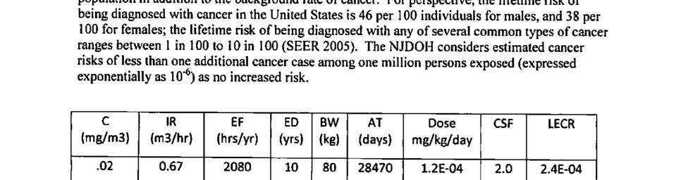
31 Cancer Health Effects The site-specific lifetime excess cancer risk (LECR) indicates the cancer potential of contaminants. LECR estimates are usually expressed in terms of excess cancer cases in an exposed population in addition to the background rate of cancer. For perspective, the lifetime risk of being diagnosed with cancer in the United States is 42 per 100 individuals for males, and 38 per 100 for females (ACS 2017). Typically, health guideline comparison values developed for carcinogens are based on one excess cancer case per 1,000,000 individuals. The NJDOH considers estimated cancer risks of less than one additional cancer case among one million persons exposed as insignificant or no increased risk (expressed exponentially as 10-6 ). According to the United States Department of Health and Human Services (USDHHS), the cancer class of contaminants detected at a site is as follows: 1 = Known human carcinogen 2 = Reasonably anticipated to be a carcinogen 3 = Not classified The Department of Health and Human Services (DHHS) Report on Carcinogens has concluded that PCBs is a category 2 carcinogen and may reasonably be anticipated to be carcinogenic to humans (NTP 2014). Cancer exposure doses were calculated using the following formula: where, Cancer Exposure Dose (mg/kg/day) = C x IR x EF x CF x ED BW AT mg/kg/day = milligrams of contaminant per kilogram of body weight per day; C = exposure point concentration of contaminant in soil (mg/kg); IR = soil ingestion rate (kg/day); EF = exposure factor representing the site-specific exposure scenario; CF = conversion factor (10-6 kg/mg); ED = exposure duration; AT = averaging time of 78 years; and BW = body weight (kg). The site-specific assumptions and recommended exposure factors used to calculate the LECR are the same as those used to assess non-cancer health effects. The LECR was calculated by multiplying the cancer exposure dose by the EPA s cancer slope factor (CSF). The CSF is defined as the slope of the dose-response curve obtained from animal and/or human cancer studies and is expressed as the inverse of the daily exposure dose, i.e., (mg/kg/day) -1. LECRs for soil exposures were calculated using the following formula [USEPA 2009]: LECR = Cancer Exposure Dose x CSF where, CSF = Cancer Slope Factor (mg/kg/day) -1 26
32 As noted in Table 7 above, an exposure duration of 10 years was used for Frameware employees since this is the time period that Frameware occupied the building. For child trespassers, an exposure duration of 5 years was used assuming that children trespassing on the site prior to it being fenced ranged in age from 11 to 16 years. The calculated LECRs for the Frameware workers and child trespassers was approximately one in 1,000,000 individuals which is considered to be a low risk for cancer (See Table 9). Table 9. Cancer Exposure Doses and LECR Calculations Exposed Population Exposure Dose * (mg/kg/day) Exposure Duration (years) Averaging Time (years) Cancer Exposure Dose (mg/kg/day) Cancer Slope Factor (mg/kg/day) 1 Site Workers 5.36E E E 06 Child Trespassers 8.84E E E 06 LECR *=Exposure dose is from Table 8; Example Dose Calculation: Exposures Dose (cancer) = 5.36E 06 mg/kg/day x (10 years / 78 years) = 6.87E 07 mg/kg/day; LECR = 6.87E 07 mg/kg/day x 2 (mg/kg/day) 1 = 1E 06 Child Health Considerations ATSDR s Child Health Initiative recognizes that the unique vulnerabilities of infants and children demand special emphasis in communities faced with contamination in their environment. Children are at greater risk than adults from certain kinds of exposures to hazardous substances because they eat and breathe more than adults. They also play outdoors and often bring food into contaminated areas. Children are also smaller, resulting in higher doses of chemical exposure per body weight. The developing body systems of children can sustain permanent damage if toxic exposures occur during critical growth stages. Most importantly, children depend completely on adults for risk identification and management decisions, housing decisions, and access to medical care. The NJDOH evaluated the potential risk for children trespassing on the former Unimatic site prior to it being fenced in April 2015, as children may have been exposed to PCBs in soil from the site. Based on the calculated exposure point concentration of PCBs in surface soils at the site, the exposure dose calculated for non-cancer health effects was below the chronic MRL, and therefore, adverse non-cancer health effects are not likely. Also, based on the exposure point concentration in contaminated soil on the site and a five-year exposure duration, it was determined that the site presented a low cancer risk. Conclusions Following the review and assessment of environmental data associated with the former Unimatic Manufacturing Corporation site, the NJDOH reached the following conclusions regarding exposures to former site workers and trespassers: 1. The NJDOH concludes that current and future exposures to PCBs in the building at the site will not harm workers health because the building is not occupied; however, past 27
33 exposures to PCBs for workers who occupied the Unimatic building may have harmed workers health. The building has been vacant since 2013 preventing workers from breathing contaminated air in the building. In addition, the USEPA plans to demolish the building as part of the September 2016 Record of Decision [USEPA 2016]. During the time the building was occupied by Frameware, Inc., workers may have been exposed to PCB levels within the building which may have put these workers at an increased risk for cancer. The data supporting this conclusion was evaluated as described in the NJDOH March 2013 Letter Health Consultation (LHC) (Appendix A). 2. The NJDOH concludes that exposures to PCB contaminated exterior surface soil on the site is not likely to harm people s health. The property is currently fenced, preventing people from contacting contaminated soil on the property. Workers at the former Unimatic facility conducted business activities inside of the building which put them at a low risk for exposure to exterior soil on the site. Therefore, a low soil contact exposure scenario was used to evaluate past worker exposures to PCBs. For child trespassers, children ranging in age from years were used to evaluate past exposures. This is because the site is located between a residential neighborhood and a high school. Using these scenarios, the exposure doses for the ingestion of PCBs in surface soil for workers and child trespassers were below the chronic ATSDR Minimal Risk Level. This level is a health based comparison value for non-cancer health effects. Additionally, the cancer risk to workers and child trespassers from ingesting PCB contaminated surface soil was estimated to be approximately one in 1,000,000 individuals. This is considered to be a low cancer risk. 3. The NJDOH cannot currently conclude whether site-related contaminants in area private wells could harm people s health. The NJDOH and ATSDR do not have the necessary information at this time to evaluate whether PCBs and other site-related contaminants have impacted downgradient private wells. The NJDOH and ATSDR are working with the USEPA to gather this information, as the extent of contamination from the site is still being characterized. Recommendations 1. NJDOH recommends the USEPA continue to characterize the extent of contamination from the site and provide this information to the NJDOH for evaluation. 2. NJDOH recommends the USEPA sample any downgradient private wells for PCBs and other site-related contaminants to determine if these wells are being impacted by contamination from the former Unimatic site. 3. NJDOH recommends that the building interior be remediated to remove PCB contamination if the former Unimatic Corporation building is to be re-occupied. The NJDOH understands that the USEPA plans to demolish the building as part of the final remedial decision for this site. 28
34 Public Health Action Plan The purpose of a Public Health Action Plan is to ensure that this PHA not only identifies public health hazards, but also provides a plan of action designed to mitigate and prevent adverse human health effects resulting from exposure to hazardous substances in the environment. Included is a commitment on the part of the NJDOH to follow-up on this plan to ensure that it is implemented. The public health actions to be implemented by the NJDOH are as follows: Public Health Actions Taken 1. The NJDOH reviewed information provided by the USEPA to evaluate the potential health implications of site contaminants to workers and trespassers at the former Unimatic Manufacturing Corporation site. 2. The NJDOH prepared a letter health consultation document in March 2013 at the request of the NJDEP which evaluated indoor environmental data and the potential worker exposures to PCBs in the building. The NJDOH recommended that workers vacate the building due to cancer risk. Public Health Actions Planned 1. Copies of this health assessment will be provided to the USEPA and to the local health department. This document will also be provided to the NJDEP and made available via the city libraries and the NJDOH website. Additionally, community members who contact the NJDOH will be provided assistance in understanding the findings of this report. 2. The NJDOH will continue to review and evaluate data as it is made available. 3. Community members or workers with health concerns regarding past exposures to site contaminants can ask the NJDOH for help with outreach between their physician and trained experts specializing in occupational and environmental exposures to hazardous substances. 29
35 References [ACS] American Cancer Society Available from: [ATSDR] Agency for Toxic Substances and Disease Registry Toxicological profile for Polychlorinated Biphenyls. US Department of Health and Human Services, Atlanta, GA. [ATSDR] Agency for Toxic Substances and Disease Registry Public Health Assessment Guidance Manual (Update). US Department of Health and Human Services, Atlanta, GA. January [ATSDR] Agency for Toxic Substances and Disease Registry ToxFAQs for Polychlorinated Biphenyls (PCBs). US Department of Health and Human Services, Atlanta, Georgia. Available from: [ATSDR] Agency for Toxic Substances and Disease Registry Exposure Dose Guidance for Soil and Sediment Ingestion. Atlanta, GA: U.S. Department of Health and Human Services, Public Health Service. October [ATSDR] Agency for Toxic Substances and Disease Registry Exposure Dose Guidance for Body Weight. Atlanta, GA: U.S. Department of Health and Human Services, Public Health Service. October [CDM Smith] CDM Federal Programs Corporation; Final Community Involvement Plan, Unimatic Manufacturing Corporation Superfund Site, Fairfield, Essex County, NJ. June 4, [GZA] GZA GeoEnvironmental Inc Preliminary Assessment Report/Site Investigation Report, Unimatic Manufacturing Corporation, Fairfield, NJ. February 15, [GZA] GZA GeoEnvironmental Inc Remedial Investigation Report/Remedial Action Workplan. Unimatic Manufacturing Corporation, Fairfield NJ. Volume 1 of 2. October 29, [GZA] GZA GeoEnvironmental Inc Supplemental Remedial Action Report. Unimatic Manufacturing Corporation, Fairfield, NJ. January 26, [GZA] GZA GeoEnvironmental Inc Second Supplemental Remedial Investigation Report. Unimatic Manufacturing Corporation, Fairfield, NJ. September 12, [GZA] GZA GeoEnvironmental Inc Revised Remedial Investigation Workplan. Unimatic Manufacturing Corporation, Fairfield, NJ. April 17, 2009 [GZA] GZA GeoEnvironmental Inc Remedial Investigation Report/Remedial Action Workplan. Unimatic Manufacturing Corporation, Fairfield, NJ. February 15,
36 [NJDOH] New Jersey Department of Health Revised Site Review and Update, Caldwell Trucking Company, Fairfield Township, NJ. August 1995 [NJDOH] New Jersey Department of Health Letter Health Consultation for the Unimatic Manufacturing Corporation. Consumer, Environmental and Occupational Health Service, Trenton, NJ. March 8, [NJDOH] New Jersey Department of Health Health Consultation Public Health Implications of Site-Related Indoor Air Exposures. Caldwell Trucking Superfund Site, Fairfield, NJ. January [NTP] National Toxicology Program Report on Carcinogens, Thirteenth Edition. Research Triangle Park, NC: U.S. Department of Health and Human Services, Public Health Service. Available from: [NUS] Nus Corporation. Remedial Investigation, Volume I. Caldwell Trucking Company Site. Fairfield, NJ. June [NUS] Nus Corporation. Offsite Remedial Investigation Report, Volume I. Caldwell Trucking Company Site. Fairfield, NJ. July [USEPA] US Environmental Protection Agency Five-Year Review Report. Caldwell Trucking Co. Superfund Site, Fairfield Township, Essex County, NJ. September [USEPA] US Environmental Protection Agency Risk Assessment Guidance for Superfund Volume I: Human Health Evaluation Manual (Part F, Supplemental Guidance for Inhalation Risk Assessment). Office of Superfund Remediation and Technology Innovation. Washington, DC. January [USEPA] US Environmental Protection Agency Removal Assessment Investigation. Unimatic Manufacturing, Incorporated Site. Fairfield, NJ. February [USEPA] US Environmental Protection Agency Office of Research and Development. ProUCL Version User Guide. Washington, DC. October [USEPA] US Environmental Protection Agency Hazard Ranking System (HRS) Package. Unimatic Manufacturing Corporation, Fairfield, NJ. December [USEPA] US Environmental Protection Agency Record of Decision, Operable Unit 1: Soil Remediation. Unimatic Manufacturing Corporation Superfund Site, Fairfield, NJ. September
37 Report Preparation This Public Health Assessment for the former Unimatic Manufacturing Corporation Site was prepared by the New Jersey Department of Health under a cooperative agreement with the federal Agency for Toxic Substances and Disease Registry (ATSDR). It is in accordance with the approved agency methods, policies, and procedures existing at the date of publication. Editorial review was completed by the cooperative agreement partner. ATSDR has reviewed this document and concurs with its findings based on the information presented. Author Christa Fontecchio, M.P.H Environmental and Occupational Health Surveillance Program New Jersey Department of Health ATSDR Reviewers Gregory V. Ulirsch, Ph.D. CDR Eva D. McLanahan, Ph.D. Technical Project Officers ATSDR Regional Representatives Leah T. Graziano, R.S. Regional Director Division of Community Health Investigations, Eastern Branch, Region 2 CDR Elena Vaouli, M.P.H. Luis Rivera-Gonzalez, Ph.D. Regional Representatives Division of Community Health Investigations, Eastern Branch, Region 2 Any questions concerning this document should be directed to: Environmental and Occupational Health Surveillance Program New Jersey Department of Health Consumer, Environmental and Occupational Health Service P.O. Box 369 Trenton, New Jersey
38
39 Figures 33
40
41 34


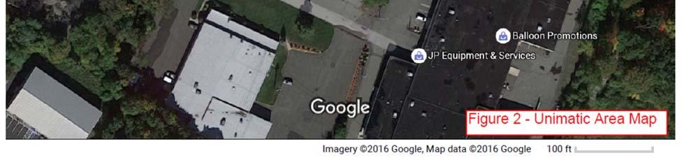
42 Figure 2. Unimatic area map 35
 Unimatic")
43 Figure 3. Unimatic site (25 Sherwood Lane) Figure 3. Unimatic Site (25 Sherwood Lane) 36
44 Figure 4 Monitoring Well Location Map - Unimatic 37
45 Appendix A New Jersey Department of Health Letter Health Consultation Unimatic Site March
46
47 39


48 40

49 41
50 42
51 Appendix B ATSDR Demographic Maps 43
52


53 44


54 45


55 46

56 47


57 48
58


59 Appendix C Site Visit Photos 21 Sherwood Lane 30 Sherwood Lane Front of Unimatic Site Building Unimatic - Right Side Fence JCMUA Lot to North of Site Unimatic - Left Side Fence 49