Integrated River Engineering Project. Catalogue of Measures. for the Danube to the East of Vienna
|
|
|
- Maryann Henry
- 5 years ago
- Views:
Transcription

1 Integrated River Engineering Project Catalogue of Measures for the Danube to the East of Vienna

2 A Catalogue of Measures for the Danube to the East of Vienna The Catalogue of Measures encompasses a multitude of river engineering measures designed to stabilise water levels, to preserve unique habitats in the Danube floodplains and to create a waterway infrastructure that fulfills the requirements of safe and economic navigation on the Danube. In order to achieve these goals we carry out continuous preservation activities and implement river engineering optimisation projects. The Catalogue of Measures is the result of an integrative planning process and is based on the findings of an optimised waterway and traffic management as well as the multi-year conception and pilot project phase of the Integrated River Engineering Project. In order to realise socially and environmentally compatible solutions, the involvement of stakeholders plays an important role alongside the scientific support of the measures.


3 Picture: Steve Haider Habitat Waterway The Danube east of Vienna forms a living band through the last great landscape of riverine wetlands in Central Europe. It is home to about 60 species of fish, more than 30 species of mammals and approximately 100 species of breeding birds. More than 800 higher-order species of plants make up this water forest. The Donau-Auen National Park was founded in 1996 to preserve this sensitive eco-system for future generations. Stabilisation of surface and ground water levels The consequences of the upstream dams of the Danube power plants are visible here, where the river can still flow freely: the natural bedload transport - the wandering of the gravel on the riverbed - is interrupted. The Danube digs ever deeper into its riverbed, water levels drop and side arms dry out. The canalisation of the river in the course of the Great Danube Regulation in the 19th century led to the mean level of the Danube s riverbed falling by about one metre within 50 years. The stabilisation (and if possible raising) of the water levels is therefore a prerequisite for the preservation of the Danube floodplains. Preservation and improvement of Danube floodplain habitats In the course of the Danube regulation the banks on both sides were protected by hard stone armouring and all secondary tributaries were thus cut off from the main river. The river and the riparian forest were decoupled from each other and this effect was worsened by the sinking water level. In addition, fine sediment deposits left by floods contribute to an increase in the height of the terrain. Due to these slow but constant changes, many typical riverine habitats have already been lost. Extensive river renaturation measures are creating new habitats for typical riverine plants and animals or enhancing existing structures. The projects are also contributing to the maintenance of the good ecological status in accordance with the EU Water Framework Directive. The Danube east of Vienna is part of an international waterway that connects the North Sea with the Black Sea. Since the opening of the Main-Danube Canal in 1992, the Rhine- Main-Danube Waterway connects a total of 14 European states. The total length between the mouth of the Danube into the Black Sea and the mouth of the Rhine into the North Sea is 3,504 kilometres. Improvement of the waterway infrastructure So that the Danube can play its role as an environmentally friendly transport alternative, shipping needs safe and economic navigable water conditions. During low water periods critical shallow points (fords) restrict the competitiveness of the inland water vessel in comparison with trucks and the railways, because ships then often have to sail with a lower load. If the navigable water depth is just ten centimetres lower, that means around 100 metric tons less load per ship unit. Almost all critical ford areas in Austria are located on the Danube to the east of Vienna. The efficient use of existing transport capacities on the Danube saves not only greenhouse gases and road infrastructure (soil sealing), but also transport costs and thus secures Austria s status as an economic location. Moreover, improved navigability of the Rhine-Danube Corridor is of importance to Europe as a whole. Transport capacity in net metric tons (nt) 1 pushed convoy with four barges: 7000 nt = 175 = 280 á 25 nt á 40 nt Distances for transporting one metric ton of goods with equal energy consumption

.")


 Height difference: approx.")
 Speed of flow: approx. 2.0 m/s (7.")


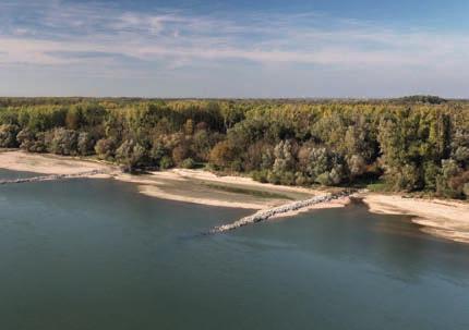
4 Riverbank restoration Natural riverbank structures are forming due to the local dismantling of the stone armour on the banks of the Danube. New habitats are being created for birds that breed on gravel banks and for typical riverine plant species (pioneer vegetation). Side-arm reconnection The river is getting part of its nativeness back and getting more space again, as a result of which the stress inflicted on the riverbed is reduced and the water level is lowered in case of flooding. Possible conflicts with flood protection, shipping, settlement areas and technical infrastructure are taken into account. Side-arms are the veins of the water forest and a type of habitat that has become rare. They shape the landscape through erosion and sedimentation. The large side-arm systems in the Donau-Auen National Park will therefore be connected more strongly to the Danube once again. The aim is to achieve long-term sustainable throughflow, so that the body The Danube to the east of Vienna in numbers Length: about 48 km, from the Freudenau power plant (river km 1,921.0) to the end of the Austro-Slovakian border stretch (river km 1,872.7) Height difference: approx. 18 m (about 40 cm/km) Water level fluctuation: up to 7 m Discharge: 1,930 m3/s (mean discharge) Speed of flow: approx. 2.0 m/s (7.2 km/h) at mean discharge of water is available almost all year round, protected against the wash of the waves from ships. By discharging water from the Danube, stress inflicted on the riverbed in the main channel is reduced and the tendency of bed erosion decreases. The high water level is also positively influenced. n... before constructio Picture: viad Picture: viad onau/zinner onau/zinner n... before constructio Picture: ARG E ID.at Specific measures for shipping and enviroment Integrative bedload management Essential for stable water levels along the entire section is the interaction of the efforts of the Verbund AG to secure the Danube riverbed over the first eleven kilometres below the Freudenau power plant with the preservation measures of viadonau on the subsequent 37 river kilometres to the Slovakian border. Optimisation of the regulating structures Zauner This counteracts the current-related removal of gravel (degradation) and thus secures the height of the bed. This bedload redistribution is enhanced by the external addition of gravel. Deep areas, in which the river has already largely washed out the gravel, are secured. Picture: Gerald In order to maintain safe and cost-effective navigable water conditions, gravel is excavated every year at the critical shallow points. Gravel is also obtained from bedload traps specially set up for the purpose. This material is taken as far upstream as possible and dumped there in areas where the riverbed is deep. In order to ensure navigability also during low water periods and to reduce the running costs of the waterway infrastructure, the low-water regulation (groynes, training structures) in critical ford areas (shallow points) are optimised. In areas of heavy riverbed erosion the regulation can be modestly lessened in order to contribute through widening (of the channel) to the relief of the riverbed and thus to the stabilisation of the water level.


5 Implementation on course Stakeholder participation Numerous river engineering measures have already been implemented on the Danube to the east of Vienna. With regard to the renaturation of large navigable rivers, new benchmarks have been set in the successfully completed Conception- and Pilot Project Phase : the first reconnection of large-scale side arm systems as well as the first complete restoration of the river banks were realised during this phase. The Thurnhaufen bank restoration realised with the Donau-Auen National Park was honored by the European Commission as the best LIFE-Nature Project 2007/2008. In order to improve navigability for the Danube navigation too, the gradual optimisation of the regulating structures is in full swing. The bedload management also commenced in 2015 in order to compensate the annual gravel deficit and thus to maintain the height of the Danube river bed and the water level. Practical experience and insights into the effects of river engineering measures on the river, nature and shipping are gathered with each project realised. The involvement of the most diverse stakeholders and civil society is an important prerequisite for the development and implementation of socially and environmentally compatible solutions. Therefore, the implementation of the Catalogue of Measures is accompanied and supported by a participation model. At the centre of the model is an advisory board made up of representatives from industry, environmental NGOs, the ICPDR (International Commission for the Protection of the Danube River), the Donau-Auen National Park and viadonau. Together they cover the majority of the existing interests. Further players who are affected or interested are involved in the course of ongoing information and discussion offerings. A learning system Picture: ARGE ID.at Picture: CD-Labor IM Fluss The Catalogue of Measures affords the flexibility required for new findings and current developments to be incorporated into the implementation. Ongoing preservation measures can be continually improved. The optimisation projects that are being implemented gradually according to their priority also enable constant further development from project to project. Continuous status evaluations and monitoring, or scientific support respectively are necessary for planning and success control. This is also a basic prerequisite for being able to take into account the insights gained from the implementation of the measures in the next steps ( learning from the river ). It is not possible in every case to fall back on existing knowledge, therefore research cooperations such as with the Christian Doppler Laboratory for Sediment research and management are being initiated for applicationoriented fundamental research, and innovations in the field of hydraulic engineering and monitoring are being advanced.


6 via donau Österreichische Wasserstraßen-Gesellschaft mbh Donau-City-Straße 1, 1220 Vienna, Austria T , F office@viadonau.org viadonau 2018 Pictures without remark viadonau Further information and status quo: Produced according to the Austrian Eco-Label criteria UZ 24 low pollutant printed products Printshop Janetschek GmbH UWNr. 637 lebendige-wasserstrasse.at