Town of Aurora Stream Management Master Plan PUBLIC INFORMATION CENTRE May 1 st, 2018
|
|
|
- Kevin Ford
- 5 years ago
- Views:
Transcription


1 Town of Aurora Stream Management Master Plan PUBLIC INFORMATION CENTRE May 1 st, 2018 Your comments are encouraged and appreciated, as this will provide us an opportunity to address project issues and concerns. 1


.")
2 STUDY PURPOSE To develop a Stream Management Master Plan based on the identification of existing erosion problems that threaten public property, health, and safety within the Town of Aurora. The Aurora stream inventory includes historically engineered, constrained, and environmentally degraded watercourses on public property that are considered to be the responsibility of the Town. This study will classify important rehabilitation projects, environmental enhancement opportunities, and other management issues to be addressed in a stream management implementation plan. PUBLIC INFORMATION CENTRE PURPOSE CONSULTATION: To provide the public with information on existing conditions and problems. The study follows the Municipal Class Environmental Assessment process which provides an opportunity for the public to offer comments and insights into the study, and to discuss related concerns with the study team. FEEDBACK: The public is encouraged to provide input at this Public Information Centre (PIC). Please provide feedback on: The prioritization of erosion sites The evaluation of alternative solutions The selection of preferred solutions 2


3 MUNICIPAL CLASS ENVIRONMENTAL ASSESSMENT PROCESS Many projects related to municipal systems are similar in nature, are carried out routinely, and have predictable environmental effects that can largely be mitigated. This study is being conducted as per the requirements for Master Plans under Approach #2 of the EA Act, which fulfills the Municipal Class Environmental Assessment process for Schedule B projects. Schedule B projects have the potential for some adverse environmental effects and generally include improvements and minor expansions to existing facilities. The flow chart below illustrates the key steps to be undertaken as part of phases 1 and 2 of the Municipal Class EA process. Phase 1 Identify Problems Identify Problem or Opportunity Public Consultation Phase 2 Alternate Solutions Identify Alternative Solutions Inventory Natural, Social, Economic Environment 3 We Are Here Environmental Impacts and Mitigation Alternatives Evaluation Review Agency and Public Consultation Select Preferred Solution Review and Confirm Choice of Schedule Notice of Completion to Review Agency & Public Implementation

4 AURORA STREAMS Field Walks Field walks were completed for Aurora streams in May and June 2017 (blue lines) General Results Hundreds of problems, opportunities and other stream management issues were identified. Problems Risks due to erosion and deteriorated infrastructure Large woody debris jams Flooding risks due to culverts Stream buffer encroachment Risks to private property Historic legacy of dams and weirs Tannery Creek Opportunities Restoration reaches Stream daylighting opportunities Highland Gate Golf Course redevelopment Natural channel infrastructure management and stream monitoring programs 4


5 EXISTING CONDITIONS St John s Sideroad A Stream Reach Classification Main Branch, Open Corridor Pond Reaches Scrub, Mixed Vegetation Grass Corridor, Golf Course Marsh Corridor Forest Corridor Urban Corridor GENERAL G H B Wellington Street A Existing Golf Courses and Parks: Limited riparian buffers in some reaches C E H Dams and Ponds: Old dams and weirs in varying states of repair and under public or private ownership D F B Channels Straightened and Engineered Historically: Deteriorated engineering structures, poor aquatic habitat G Main Branch Corridor: Wide floodplain and valley corridors with mixed riparian vegetation C Legacy of Highland Golf Course and Redevelopment: No riparian buffer; old structures, bridges, dams, ponds D Recent Channel Engineering: Constrained urban stream reaches stabilized with armourstone and round stone E Forested Stream Reaches: Influenced by woody debris in the channel F Riverine Meadow Corridors: Wide and open corridor of marsh and wetland species, without defined channels 5


6 EXISTING CONDITIONS St John s Sideroad Stream Reach Classification Main Branch, Open Corridor Pond Reaches Scrub, Mixed Vegetation Grass Corridor, Golf Course Marsh Corridor Forest Corridor Urban Corridor PROBLEMS E B A Erosion: Bank erosion and slope instability putting public and private properties at risk A D Wellington Street C G H Lack of Riparian Buffer: Private yards and golf courses impact streams by removing or limiting riparian cover H F B Deteriorating Structures: Old engineering treatments in poor condition putting property and habitat at risk G Hydraulic Pinch Points: Undersized culverts constrain high stream flows increasing risks of flooding and erosion C Stream Buffer Encroachment: Structures and landscaping on private property impacting stream health D Large Woody Debris Jams: Risks due to sources of woody debris that create jams and flooding hazards E Dams and Weirs: In varying states of repair and under public or private ownership influencing flood risks F Piped Stream Reaches: Long sections of stream systems are piped underground, excluding aquatic habitat 6


7 FIELD INVENTORY EROSION SITES: where unstable stream channels pose risks to public infrastructure, property, and aquatic habitat Tannery Creek 33 OTHER MANAGEMENT ISSUES: where stream systems may require special management considerations to address risks OMI Examples: dams, weirs, flood hazards, debris jams, stream buffer encroachment, and restoration opportunities. Field Site Classifications 7

 Component Criteria St John s Sideroad 4 5 1 2 3 4 5 6 7 8 Devlin Place Jones Court Wellington Street Willow Farm Lane Manhole Study Tyler")
8 PRIORITIZATION Top 8 Projects for Implementation Plan Erosion sites have been organized into ten (10) categories based on: Field site classifications (i.e., similar problems) Field scoring (see tables below) Site locations and property ownership data Field Scoring of Erosion Sites (out of 100) Component Criteria St John s Sideroad Devlin Place Jones Court Wellington Street Willow Farm Lane Manhole Study Tyler Street Sandusky Park Harriman Road 1. Erosion and Risk 70% Erosion Index (35) Public Health and Safety (35) 8 2. Environmental Opportunity 30% Enhance Riparian Buffer (15) Enhance Aquatic Habitat (15) Erosion sites with field scores between were considered for high priority projects. Moderate priority field scores between were considered for integration with high priority projects based on proximity and similar problem types. Low priority sites with field scores below 65 were identified for future monitoring by the Town. Identification of the Top 8 Projects Field scores, property ownership, and infrastructure at risk were used to identify the Top 8 projects* Score Ownership Risks 80 Public Public Infrastructure 79 Public Private Property 84 &74 Public/Private Public Infrastructure 77 Public Public and Private Public/Private Public Infrastructure 79 Private/Public Public and Private 64 Public/Private Public and Private 75 Public/Private Public and Private *5 similar and adjacent erosion sites also added to Top 8 sites Wellington Street 5 Remaining 20 of 33 erosion sites within the Stream Master Plan Description Field Scores # of Sites Existing Projects 78 & 91 2 Reach Scale Opportunities 3 Small Dams (private & public) 3 Private Property 5 Monitoring (low priority) 7 * Existing conditions and photographs of the Top 8 projects are presented on other individual PIC poster boards
 H Old concrete")

 Risks to public")


 C Failing slope behind failed wall")
 E Erosion")
 F Outfall")
9 1. DEVLIN PLACE H A Wall of gabion baskets leaning (looking upstream) H Old concrete dam outlet structure (looking upstream) B A D C G F E B Wall of gabion baskets undermined, toppled into channel (looking downstream) Risks to public infrastructure, private property, and aquatic habitat due to: Failed gabion basket retaining wall Bank erosion, including instability of storm water outfall channel Deterioration of old concrete dam structure G Bank erosion near private property and fence lines (looking east) C Failing slope behind failed wall of gabion baskets (looking west) D Rip-rap lined channel (looking upstream) E Erosion of outfall channel filled with woody debris (looking downstream) F Outfall channel adjacent to private yards (looking upstream) 9

10 10 1. DEVLIN PLACE

11 11 1. DEVLIN PLACE
 E H")
 F G H B Straightened and")
 Risks to")


 E")
 F Bank erosion and falling debris at")
12 2. JONES COURT A B C D A Bank erosion adjacent to property and fence line (looking upstream) E H Local landowner bank protection using bricks (looking upstream) F G H B Straightened and constrained channel with historic drainage structures, half CSPs (looking downstream) Risks to public infrastructure, private property, and aquatic habitat due to: Deterioration of historic drainage structures (half pipes, CSP) Bank erosion and slope failure, including undermined trees Highly constrained urban stream channel between private properties G Bank erosion near private property and fence lines (looking upstream) C Bank erosion adjacent to property and fence lines (looking upstream) D Bank erosion with trees falling into the channel (looking upstream) E Straightened and constrained channel with historic drainage structures, half CSPs (looking upstream) F Bank erosion and falling debris at fenceline (looking upstream) 12

13 13 2. JONES COURT

14 14 2. JONES COURT
 H Slumping and")
 A B C D B Gabion baskets undermined,")


 E")
 F Build up of wood and debris jamming the")
15 3. WELLINGTON STREET E F G H A Gabion baskets on channel bed undermined and broken (looking upstream) H Slumping and erosion of road embankment around CSP drainage outfall (looking downstream) A B C D B Gabion baskets undermined, broken and leaning into the channel (looking upstream) Risks to public infrastructure, private property, and aquatic habitat due to: Failed and broken gabion baskets on bed and bank downstream of culverts Bank erosion and slope failure along road embankments, exposed CSPs Constrained and entrenched channels, with hydro poles and debris jams G Bank erosion along road embankment (looking upstream) C Straightened and entrenched channel along roadside with hydro poles in the channel (looking downstream) D Bank erosion and slope failure along the road embankment (looking upstream) E Scour downstream of culvert with exposed concrete footing (looking downstream) F Build up of wood and debris jamming the channel with scour around drainage outfalls (looking upstream) 15

16 3. WELLINGTON STREET 16

17 3. WELLINGTON STREET 17

18 3. WELLINGTON STREET 18

19 3. WELLINGTON STREET 19
 B A C D")
 B Steep channel")
 Risks to public infrastructure, private")


 20")
20 4. WILLOW FARM LANE A Local slumping of slope near property and fence lines (looking downstream) B A C D E F G H H Scour and broken gabion baskets at elevated storm outfall (looking upstream) B Steep channel between gravel trail and valley embankment (looking downstream) Risks to public infrastructure, private property, and aquatic habitat due to: Bank slumping,slope failure, and falling trees near property and fence lines Failed and broken gabion baskets at storm water outfall Surface erosion and slope failure along gravel trail system G Surface erosion and slope instability along existing trail system (looking upstream) C Steep channel between gravel trail and valley embankment (looking upstream) D Channel drops off into entrenched gully downstream of CSP culvert (looking upstream) E Slumping of valley wall materials and trees along fence line (looking downstream) F Slumping of valley wall materials and trees along fence line (looking upstream) 20

21 21 4. WILLOW FARM LANE

22 22 4. WILLOW FARM LANE


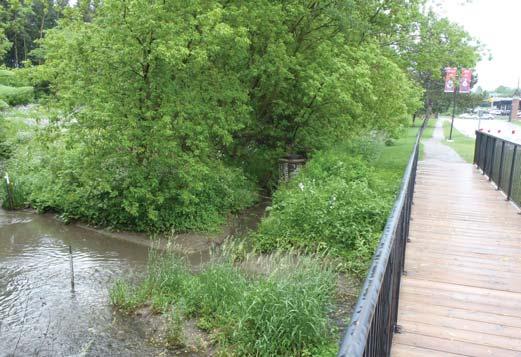
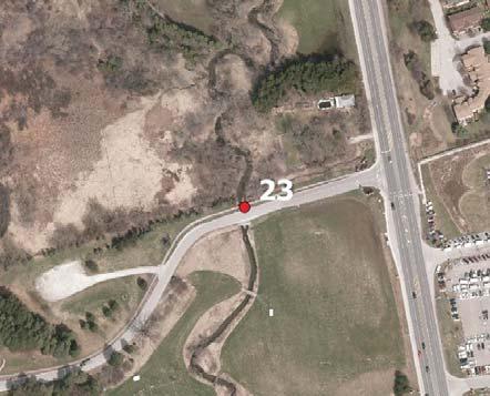
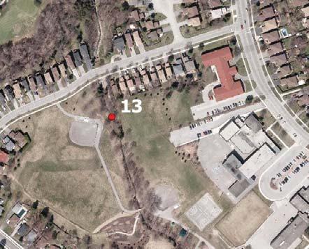
23 5. MANHOLES IN CREEKS Exposed manhole in channel of Tannery Creek Exposed manhole in channel of Tannery Creek Risks to public infrastructure: Sanitary sewer manholes Airphoto view of manhole location, Erosion Site 13 Airphoto view of location, Erosion Site Exposed manhole in channel of Tannery Creek Airphoto view of manhole location, Erosion Site 3 Airphoto view of manhole location, Erosion Site Exposed manhole in channel of Tannery Creek

24 5. MANHOLES IN CREEKS 24

25 5. MANHOLES IN CREEKS 25

26 26 6. TYLER STREET

27 27 6. TYLER STREET

28 28 7. SANDUSKY PARK

29 29 7. SANDUSKY PARK

30 30 8. HARRIMAN ROAD

31 31 8. HARRIMAN ROAD


: Reduced capacity creates backwater and flood prone areas Legend Flood Risk Areas 32 *")
32 FLOOD RISK AREAS The Aurora stream inventory identified erosion issues, deteriorated channel infrastructure, and flood prone areas. In many cases, flood risks were in the same locations as erosion sites. Additional consideration of the alternatives will be given to address flooding and erosion at the same time. Previously identified flood risk areas are shown on the adjacent map. Hydraulic Pinch Points (Area 3): Undersized culverts constrain high stream flows increasing risks of flooding Submerged/Buried Culverts (Area 4): Reduced capacity creates backwater and flood prone areas Legend Flood Risk Areas 32 * Existing conditions and photographs of the Top 5 Projects are presented Erosion on Sites other individual PIC poster boards


 Public Information Centre (PIC#3) Present")


33 NEXT STEPS ADDITIONAL FLOODING INVENTORY Receive PIC#2 feedback, incorporate input and update results Identify and prioritize Erosion Restoration Areas and Flood Risk Areas Confirm preferred solutions PUBLIC CONSULTATION Final (3 rd ) Public Information Centre (PIC#3) Present final results of Master Plan, addressing Erosion & Flooding STREAM MANAGEMENT MASTER PLAN REPORT Implementation Plan Maintenance and Monitoring Plan Development Present Master Plan Report to Council Winter