Using GIS as the Backbone of the World's Largest Water Conservation Rebate Program
|
|
|
- Dorthy Gibbs
- 5 years ago
- Views:
Transcription

1 Using GIS as the Backbone of the World's Largest Water Conservation Rebate Program Lou Reinbold Asst. Conservation Programs Coordinator, SNWA

2 Southern Nevada Water Authority (SNWA) Member Agencies Big Bend Water District City of Boulder City City of Henderson City of Las Vegas City of North Las Vegas Clark County Water Reclamation District Las Vegas Valley Water District


3 CHALLENGES In the 1990 s Southern Nevada hit a crisis point: additional water was needed to meet growing demands. Population , , , , , ,400, ,006,000


4 LAS VEGAS AND WATER + What do you think of?


5 The Bellagio

6 The Venetian


7 The Colorado River Basin is facing one of the worst droughts in recorded history.


8 The Southern Nevada Water Authority meets the water demands of Southern Nevada s 2 million residents and 40 million annual visitors. Youngest city of more than 2 million people in the U.S. $93 Billion in Gross Domestic Product 71% of Nevada s Total Gross Domestic Product Founded in million visitors annually 330 days of sunshine a year and a low cost of living.

9 Colorado River UPPER DIVISION 7.5 million afy Colorado: 3,900,000 Nevada: 300,000 Wyoming: 1,000,000 Arizona: 2,850,000 New Mexico: 850,000 California: 4,400,000 Utah: 1,700,000 LOWER DIVISION 7.5 million afy
10 Lake Powell s annual inflows continue to be below normal. 140% 139% 120% 100% 105% 102% 88% 96% Normal Inflows 80% 60% 62% 59% 53% 51% 73% 68% 73% 45% 47% 40% 25% 20% 0%
11 Elevation As a result, Lake Mead water elevations have declined more than 100 feet during the past 14 years. 1,220 1,200 1,180 1,160 1,140 1,120 1,100 1,080 1,060 1,040 1,020 1,000 Powell Filling
 Current elevation 1,089 ft.")
12 LAKE MEAD ELEVATION 1,220 ft. 41% of capacity Intake 1 Intakes 2 & 3 (Mead at 17% of capacity) Current elevation 1,089 ft. 1,050 ft. 1,000 ft. Hoover Dam Current Colorado River System Content: 49%


13 Inner Las Vegas Bay March 7, 2000, elevation 1213 Feet April 11, 2002, elevation 1170 Feet

14 Return-flow credits allow Southern Nevada to reuse 99% of the water used indoors. Conservation Programs are targeted at the outdoor water use that can t be re-used. Outdoor water use in Southern Nevada makes up 60% of total usage.
15 How is Water Used? Common Areas, 5.7% Other, 1.7% Schools/Govt/Parks, 5.8% Golf Courses, 6.5% Residential (SF), 44.5% Resorts, 7.7% Notes: (a) Municipal metered water consumption billed to customers from all sources (potable and non-potable). Commercial / Industrial, 12.4% (b) Potable includes ground water and Colorado River water (c) Non-Potable includes raw Colorado River water, reclaimed and reused water (d) Reflects the service areas of all SNWA agencies providing potable and/or reclaimed water. Residential (MF), 15.7%


16 WaterSmart Landscapes Program Began in Customers are paid to remove turf from their landscape and replace it with desert landscaping. $1.50 per square foot (up to 5,000 sq ft) then $1.00 per square foot up to $300,000 per property per year. Irrigation and planting requirements Ensure permanent water savings though a Conservation Easement placed on the land.


17 WSL Program to Date Converted of 170,000,000 Sq Ft of turf Conversions have resulted in a savings of over 78,000,000,000 gallons of water! New water savings of approximately 9.6 Billion gallons per year 3,000 landscape conversion annually All properties are measured by Conservation field staff
18 Turf Analysis Project (TAP) Technical Details Custom ArcGIS Application using an ArcMap add-in Utilizes ArcGIS Server and LizardTech Numerous Data Layers Interfaces with multiple applications Vital to the creation of Conservation Easement Legal Documents On Average 8,000 maps per year are created using TAP 2,000 Pre Conversion Maps 3,000 Post Conversion Maps 3,000 Exhibit C Maps


19 TAP Diagram

20 Parcel Information / Application Overview

21 Shapefile Creation & Drawing Toolbar Notes: Shapefiles are automatically created based on property & work order attributes. Custom Toolbars created with program necessary buttons. Some buttons are greyed out unless a user is in a specific user class. Historical shapefile archive for all properties.


22 Map Creation
23 Map Creation Legal Templates Dynamic Fields 1. Parcel Number 2. Total Square Footage and Rebate Amount 3. Legal Description Notes: Exhibit C map is a requirement for the creation of the Conservation Easement. Map format is automated. Format is fixed to comply with PRIA standards. User simply verifies data and saves the map.

24 What s Out There?

25 What s Out There?

26 Target Marketing
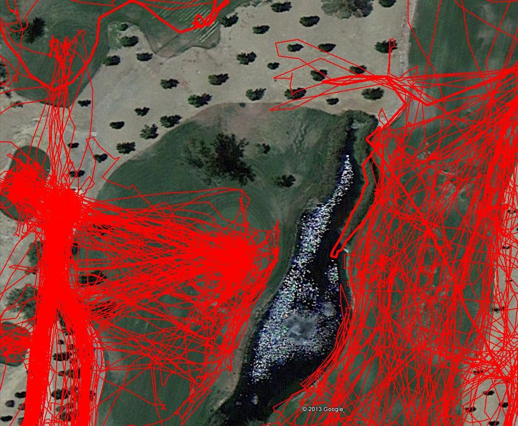
27 Golf Course Play Areas What if we can visualize where the players actually go on courses? This can tell us where ideal prospective future areas for conversion are. We can examine past conversions and see if the selections were good fits for the players. While these are the primary areas of interest for SNWA, other findings can be made,including: Pace of play per hole and even per shot/ (and how might that relate to conversions) Maintenance efficiency for a given area. Mowing pattern efficiency.

28

29
30
31 Conservation Achievements Our community has made significant conservation achievements. Consumptive Water Use (acre-feet) 300, , , , , , , , , , , , , , Southern Nevada uses nearly 90,000 fewer acre-feet of water than it did just over ten years ago, despite an annual population increase of nearly 500,000 residents and millions of annual visitors.


32 Fun Facts Southern Nevada has removed enough grass for a roll of sod to extend 87% of earth s circumference! Enough water has been saved to: Fill 882,000 Olympic Swimming Pools Fill the Luxor Hotel Pyramid 217 times Fill the Empire State Building 283 times Saved 240,234 acre feet of water. Entire years' worth of water saved!
33 Questions? To learn more please visit snwa.com watersmartinnovations.com Lou Reinbold