Parks and Open Space 5201 St. Vrain Road Longmont, Colorado Fax:
|
|
|
- Spencer Logan
- 5 years ago
- Views:
Transcription
1 Parks and Open Space 5201 St. Vrain Road Longmont, Colorado Fax: HALL RANCH 2 ACCESS ROAD REPAIRS Project Summary for Limited Impact Special Use Review Date: June 15, 2017 Project location: West of Lyons off Highway 7 on Old South St. Vrain Road Project purpose: To restore the access road to its pre-flood function, location, and capacity To protect the roadway from erosion during future flooding To realign South St. Vrain Creek sufficient to allow for reconstruction To employ design strategies that support the ecosystem functions of the riparian corridor OVERVIEW The purpose of Hall Ranch 2 Access Road Repair (the project) is to restore access to Boulder County s Hall Ranch 2 open space property from Old South St. Vrain Road by repairing damage to the road caused by the 2013 flood and by moving South St. Vrain Creek back to its pre-flood location. Mitigation measures are also incorporated into the design of the project to minimize the potential for flood-caused erosion in up to 100-year events. The important ecosystem functions of the riparian area are supported by the inclusion of natural channel design elements and by minimizing the overall project footprint while also complementing the objectives of other flood recovery projects along the creek such as the Boulder County South St. Vrain Creek Restoration Project at Hall Meadows. The project is located along a one-half mile section of damaged access road. Flooding and high water velocities during the disaster stripped the gravel road surface, eroded gullies through the road surface and sub-base, and damaged culverts. Debris flows across the road also clogged roadside ditches with sediment and other debris. Most significantly, a 240 foot section of the access road was completely eroded where the channel of South St. Vrain Creek shifted into the road alignment. In order to reconstruct the road in this area, it is necessary to move the creek channel back to its pre-flood location in order to make room for the proposed road reconstruction. The channel will be constructed such that it safely conveys the 100-year flood event. A low-water crossing is also being added to convey drainage from a tributary to the creek that must cross the road to connect to South St. Vrain Creek. Even though an open space management plan has not yet been adopted for this property, it shares many of the same open space values and functions as the adjacent Hall Ranch and Heil Valley Ranch open space properties. An interdisciplinary team of Parks and Open Space staff have been involved in the design development process to ensure these values and characteristics have been thoughtfully considered in the design. Design plans are attached. Cross-sections drawings and design reports are available at: Cindy Domenico County Commissioner Deb Gardner County Commissioner Elise Jones County Commissioner

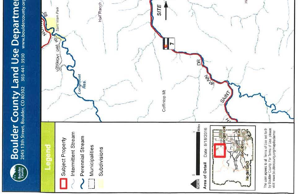

2 PROJECT LOCATION
3 PROJECT CONTEXT The Hall Ranch II property is located southwest of the Town of Lyons and is nestled between the Hall Ranch Open Space to the north and the Heil Valley Ranch Open Space to the south. South St. Vrain Creek flows through the property from west to east. This open space complex is a gateway to a nearly contiguous collection of public lands that stretch along South St. Vrain Creek and State Highway 7 to the Peak to Peak Highway. While the Hall Ranch 2 property itself does not yet have an adopted management plan, the North Foothills Open Space Complex Management Plan covers more than 11,000 acres, including Hall Ranch and Heil Valley Ranch. These are two of the county s largest, most beloved open space areas. This area is rich in significant environmental resources as described in detail in the discussion of the Boulder County Comprehensive Plan below. And, as reflected in the North Foothills Open Space Management Plan, the area has long been recognized as significant for their beauty, natural resources, and cultural value. 1 The protection of these lands provides for the conservation of the scenic quality, natural and cultural resources, wildlife habitat, native plant communities, and natural ecosystem processes. As the Management Plan recommends, the proposed project seeks to balance these open space values. PROJECT OBJECTIVES While Parks and Open Space is endeavoring to implement a more holistic stream restoration for South St. Vrain Creek, the purpose of this project is limited to restoring the access road into the Hall Ranch 2 property and to providing erosion mitigation measures. As such, this project targets the road and a short segment of stream immediately adjacent to the washed out portion of the road with the following project objectives: 1. Restore the roadway to its pre-flood location, function and capacity. 2. Incorporate roadway drainage features, armoring and other measures that protect the roadway from erosion during flooding. 3. Realign the creek sufficient to allow for the reconstruction of the roadway 4. Employ design strategies such as natural channel design that also support the ecosystem functions of the riparian corridor and other valuable natural resources in the area. PROPOSED REPAIRS The project has three main components: channel realignment (600 linear feet), roadway repair and reconstruction (2,150 linear feet), and a low-water crossing. 1 Boulder County Parks and Open Space, North Foothills Open Space Management Plan, (1996), page 7 of PDF, Project Summary for LISU PAGE 3 Hall Ranch 2 Access Road Repairs 06/15/2017
4 Channel Realignment The primary purpose of the channel realignment is to allow for reconstruction of the roadway and integration of mitigation measures that limit erosion and prevent the type of damage that occurred during the 2013 event. The overall strategy for the 600 linear foot design reach is to create a stable creek channel that utilizes a combination of natural materials to provide erosion protection and also to support the ecosystem functions of the riparian corridor. This design approach was favored over the armoring of the creek embankment on the inside and outside of the curve with a more homogenous application of rip-rap. The design reach includes a two stage channel cross-section through the bend in the creek. The embankments on the outside and the inside of the bend employ two distinctive but related design features to protect the road from the erosive forces associated with flood conditions. Along the outside bend, boulder toe protection will be used to withstand scour and help stabilize the primary channel up to the bank full depth (stage one). Above the toe protection, soil riprap will be used on the roadway embankment to one foot above the 100-year event depth. This is intended to protect the embankment from tractive forces through that section during a larger flood event. Native seeding in the soil riprap will further stabilize and protect the new roadway embankment and help provide habitat connectivity along the riparian corridor. On the inside bend, some minor grading will help flows expand more easily and access the upland area during larger events. This expansion of the floodplain will take pressure off the embankment along the outside curve when flows exceed the bank-full depth. Cobble material excavated on site will be utilized on the inside of the bend to help stabilize the main channel and limit erosion on the embankment up to the bank-full depth. This cobble embankment will also be planted with native willow stake plantings. Repair of the Roadway and Stormwater Management Repair of the roadway consists primarily of reconditioning and resurfacing about 2,150 linear feet of the pre-existing road with a 6-inch thickness of Class 6 Road Base. Consistent with county standards for a private road, the travelway will consist of two 9-foot lanes with a 2% cross-slope and two 2-foot shoulders with a 4% cross-slope for a total width of 22 feet. Only a minimal amount of cut/fill is needed to accomplish these repairs with two exceptions, the area where the creek now flows through the former road alignment (STA 20+05) and some fill at the very west end of the project (STA 2+00). The overall storm water management design for the roadway itself has been reconfigured. Instead of the roadside ditch system that was in place prior to the flood, a cross slope of 2% to 4% across the road surface will direct flows toward the creek. In two locations, culverts will convey some flow beneath the roadway. At STA 17+90, an existing culvert will continue to convey some local drainage. And, at STA 16+32, a new double culvert and low-water crossing are proposed as described below. The purpose of these improvements to the drainage system is to better protect the roadway from erosion. Low-Water Crossing In the vicinity of STA16+50 some conveyance and a road crossing is planned to carry flows from an ephemeral drainage area located south of and above the road. This is a naturally connected tributary to South St. Vrain Creek. Prior to the flood, these ephemeral flows met the Project Summary for LISU PAGE 4 Hall Ranch 2 Access Road Repairs 06/15/2017
5 road at STA and were directed along the road in a small, roadside ditch northward to the culvert at STA However, the existing facilities did not manage flows during the 2013 flood sufficiently, and as a result, the road was significantly scoured in this area. A low-water crossing is proposed at STA to more efficiently convey ephemeral flows from the entire one square mile drainage area beneath and/or across the road. The low-water crossing will consist of two elliptical reinforced concrete pipe culverts. The road surface will consist of a 30-foot long reinforced concrete surface, or low-water crossing, that will protect the road from erosion in high flow events when surface drainage would cross over the roadway. For scour protection, riprap and geotextile will protect the roadway embankment on either end of the culvert. The new swale will connect with the main channel at the upstream end of the embankment s boulder toe protection and transition to the creek with a small area of e rip-rap. EARTH WORK AND IMPORTED MATERIALS EARTHWORK QUANTITIES A total of approximately 9,079 cubic yards of earthwork is estimated for this project. The quantity of cut material is estimated to be 4,994 cubic yards. The quantity of fill material is estimated to be 4,085 cubic yards. Fill material includes about 840 cubic yards of imported aggregate materials and 3,245 cubic yards of material excavated on site. These quantities are tabulated in Table 1 (below) and further summarized on the Earthwork and Grading Worksheet (attached). ONSITE EXCAVATION AND EXCESS MATERIAL As noted above, the majority of the earthwork for this project is unclassified excavation undertaken to realign the creek and reconstruct the road. A total of 4,664 cubic yards of unclassified excavation (i.e., cut) will occur throughout the project area. 2,982 cubic yards will remain onsite when compaction is taken into consideration. The material will be used primarily to reconstruct the roadway embankment at the bend in the creek. The remaining 1,682 cubic yards of excavated material along with 67 cubic yards of material excavated to construct the lowwater crossing structure will be removed from the project area (1,749 cubic yards total). Parks and Open Space is in discussion with the operator of the old mine site on the property to determine whether or not the excess material can be placed there and used as part of their upcoming reclamation. If this excess material cannot be used for the reclamation, it will become the responsibility of the contractor to haul the excess material offsite for disposal. An additional 159 cubic yards of top soil and 44 cubic yards of wetland soil will be stockpiled and reused to facilitate revegetation in areas identified in the revegetation plan (Drawing No. 17). Project Summary for LISU PAGE 5 Hall Ranch 2 Access Road Repairs 06/15/2017
6 Table 1. Hall Ranch 2 Access Road Repair Earthwork Tabulations Description of Earthwork (On site) Unit Roadway Channel Low Water Crossing Cut Fill Cut Fill Cut Fill Unclassified excavation CY Topsoil CY Wetland topsoil CY Structure excavation CY 67 Dry Rubble Slope & Ditch Paving CY Subtotals CY Total cut CY Total onsite material placed as fill CY Excess cut material for disposal CY 1749 Import Materials (Add'l Fill) Riprap (Special) 390 tons CY 195 Riprap (9 inch) CY Riprap (18 inch) CY 90 Soil riprap (9 inch) CY 282 Structural backfill (Class 1) CY 51 Concrete Class B CY 10 Subtotal of Imported Material CY Onsite fill (from above) CY Total Fill CY Total Cut (from above) CY Cut+Fill totals CY Notes (1) All quantities based on tabular information on Sheet 5 except "Unclassified Excavation" which is summarized on upper left table on Sheet 6. A compaction factor of 1.10 is included in fill quantities shown above. (2 )Excess material from unclassified excavation of 1749 cubic yards will be transported offsite and be the responsibility of the chosen contractor. Location to be determined at a later time. (3) Converted tons of aggregate base course using 1.35 tons/cubic yard (4) Converted Riprap (Special) using 2 tons/cubic yard Project Summary for LISU PAGE 6 Hall Ranch 2 Access Road Repairs 06/15/2017
7 IMPORTED MATERIAL Aggregate materials in the amount of 2,198 cubic yards will be imported and used for the purposes identified below. However, only 840 cubic yards of imported material is included in the fill calculation in Table 1 since the road base quantity is not included in the fill tabulation: 390 tons of riprap (Special) or approximately 195 cubic yards will be used to construct the toe wall at the base of the roadway embankment along the outside bend of the river channel. 180 cubic yards of riprap (9 inch) will also be used along the outside bend of the river channel to stabilize the embankment. Another 32 cubic yards of riprap (9 inch) will be used to at the culvert outlet of the low water crossing. 90 cubic yards of riprap (18 inch) will be used to stabilize the embankment on both sides of the low water crossing. 282 cubic yards of soil riprap (9 inch) will be used to stabilize the road embankment. 60 cubic yards of dry rubble slope and ditch paving will be used to stabilize the inside bend of the river channel (suitable material may be available within the project area). 51 cubic yards of structural backfill will be used at the low-water crossing 10 cubic yards of concrete (Class B) will be used to hard surface the low water crossing tons of aggregate base course (Class 6) or approximately 1,349 cubic yards will be used to resurface the road. OTHER CONSTRUCTION-RELATED CONCERNS HAUL ROUTES, ACCESS POINTS & TRAFFIC MANAGEMENT CONCERNS All construction traffic is anticipated to come from east of the project area. It will be routed into and through Lyons via US Highway 36 or State Highway 66, then through town on US Highway 36. At the T intersection, traffic will turn left onto State Highway 7. It will then be routed up Old South St. Vrain Road to the property s entrance gate. Regular construction traffic will be minimal and no traffic management issues are anticipated. If the county s new Andesite Bridge is completed before or during this project, construction traffic could then bypass Old South St. Vrain Road and cross at the bridge which will terminate near the property s entrance gate. It is likely that creek access for construction will occur at the north end of the project area near the washed out segment of road. It is expected that this will be finalized by the contractor when applying for future county permits. Project Summary for LISU PAGE 7 Hall Ranch 2 Access Road Repairs 06/15/2017
8 ESTIMATED CONSTRUCTION DURATION AND ESTIMATED START DATE. It is estimated this project will start in the fall of The exact start date is dependent upon final funding and approval and environmental review from FEMA, river water levels and chosen contractor availability. Active construction is expected to last about 3 months. EROSION CONTROL AND REVEGETATION Erosion control will be completed in all disturbed areas as depicted in the attached plans (Drawing Nos. 14 and 15). A Storm Water Permit will also be obtained and complied with. A combination of best management practices, plans designed to minimize erosion and environmental impacts, erosion control logs, silt fencing, check dams, geotextile, willow plantings, and various materials to stabilize new embankments will be used to control erosion. In addition, the project will have an Erosion Control Supervisor assigned to ensure these practices are implemented throughout the project and until the conditions of the Storm Water Permit are complete. Revegetation efforts will start with top soil and wetland soils from the affected areas being salvaged and stockpiled. Salvaged soil will then later be placed as part of the revegetation plan. Both an upland seed mix and a mesic/wetland seed mix are specified and delineated on the plans (see Drawing No. 17). In the seeding areas, the stockpiled soil will be placed, the soil conditioned, native seed planted and weed free hay mulched and mulch tackifier applied to ensure successful reclamation and no unnecessary erosion. The wetland areas will be planted with a mesic/wetland seed mix covering more than twice the area of impacted wetlands (0.108 acres impacted, 0.24 acres revegetated). In addition, 400 willow cuttings will be installed along the inside bend of the stream just above the bank-full elevation for erosion control and habitat restoration. Willow cutting will also be installed along the flow-line of the constructed tributary alignment on either side of the low-flow crossing. DEMARCATED STAGING AND REFUELING AREAS Staging and refueling areas, as well as limit of construction, are designated in the plans (Drawing No. 14 and 15). REQUIRED PERMITS AND OTHER APPROVALS Section 7 Clearance (Endangered Species Act) Clearance is expected under FEMA s Programmatic Agreement with USFWS. Conservation Measures are built into the Project. US Army Corps of Engineers- A Nationwide Permit from the for this project is being sought. Migratory Bird Treaty Act (MBTA) If necessary based on project timing, a Wildlife Biologist will conduct a nesting bird survey to assist with MBTA clearances and implementation of wildlife-related conservation measures. Colorado Parks and Wildlife (CPW)- Coordination with CPW will occur to address any MBTA concerns and also to address SB40. Project Summary for LISU PAGE 8 Hall Ranch 2 Access Road Repairs 06/15/2017
9 Section 106, National Historic Preservation Act SHPO clearance will be obtained through the Programmatic Agreement with FEMA. County Floodplain Development Permit - A Hydrology & Hydraulics report has been prepared to support the anticipated need for a Floodplain Development Permit from Boulder County Transportation since this project lies in the 100-year floodplain. A preliminary meeting with Floodplain staff has already occurred. County Grading Permit a grading permit will be sought from Boulder County once a contractor is on board to give the contractor the opportunity to provide input on how to satisfy potential permit conditions. COMPATIBILITY WITH THE BOULDER COUNTY COMPREHENSIVE PLAN There are an abundance of designations from the Environmental Resource Element, Open Space Element, and Cultural Resources Elements of the Boulder County Comprehensive Plan (BCCP) mapped in this area. This preponderance of these significant resources made the acquisition of this property and adjacent properties as open space a priority. As the design solution was formulated, an interdisciplinary team of Parks and Open Space staff were involved in order to ensure that the diverse open space resources and values associated with the project area were considered and incorporated into the final construction plans. The project is designed to be resilient in the face of the erosive forces that the BCCP describes as potential hazards and threats. The natural channel design approach and revegetation efforts being implemented through the stream reach promote ecosystem function and support the longer-term restoration of the creek s more sensitive riparian resource values that were diminished even before the flood occurred. In addition, the low-water crossing that conveys flows from the tributary is being constructed in a manner that supports habitat connectivity for amphibians and butterflies along the tributary better than the previous somewhat ad-hoc drainage configuration that was present before the flood. The restoration will also provide potential habitat for Preble s Meadow Jumping Mouse. Other ERE designated resources are similarly supported by the design such as Critical Wildlife Habitats as well as Open Streamside Corridor and Open Roadside Corridor designations The surrounding lands are also rich in cultural history beginning with the early period of settlement of the area. The historic rural, agricultural feeling and setting are particularly well preserved in the nearby building clusters that have retained their connection to the use of the lands for agricultural purposes, particularly cattle ranching. Ranching had continued on the surrounding lands up until the sale of the surrounding property by the Hall family to Boulder County beginning in the 1990s. The area in which work is planned has already been significantly altered by the flood and the work returns the facility to its pre-flood location, function and capacity. As such the project will be compatible with the historic character and/or historic spatial pattern of the project area. Project Summary for LISU PAGE 9 Hall Ranch 2 Access Road Repairs 06/15/2017
.")
10 View to road wash-out area looking downstream (May 2016). View upstream from road washout area (May 2016). Project Summary for LISU Hall Ranch II Access Road Repairs Photo Sheet 1`
11 View looking downstream from road washout area (May 2016). View to North of far bank where grading will occur to create floodplain access. Two trees are proposed for removal (May 2016). Project Summary for LISU Hall Ranch II Access Road Repairs Photo Sheet 2`
.")
.")
12 View of proposed low-water crossing area where waters from tributary scoured the road (January 2014). View to the east from near quarry of scoured road surface (January 2014). Project Summary for LISU Hall Ranch II Access Road Repairs Photo Sheet 3`
")


13 OVERVIEW OF PROJECT AREA (View looking south) TRIIBUTARY QUARRY WASH--OUT Project Summary for LISU Hall Ranch II Access Road Repairs Photo Sheet 4`


14 THE ROAD WASHOUT AREA AND TRIBUTARY CROSSING THE ROAD (View looking EAST) WASH--OUT TRIIBUTARY Project Summary for LISU Hall Ranch II Access Road Repairs Photo Sheet 5`