Public Notice.
|
|
|
- Margery Bryant
- 5 years ago
- Views:
Transcription

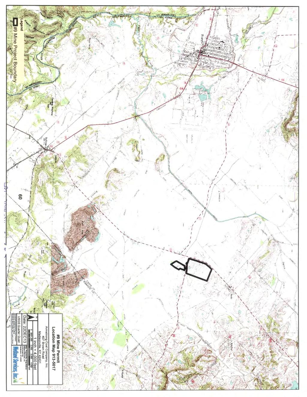
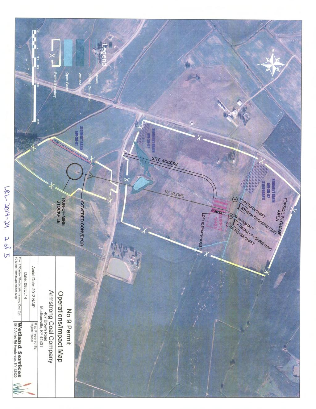
1 Public Notice US Army Corps of Engineers Louisville District Public Notice No. Open Date: Close Date: LRL mad 4 Aug Sep 2014 Please address all comments and inquiries to: U.S. Army Corps of Engineers, Louisville District ATTN: Mr. Matt Dennis, CELRL-OP-FW 6855 State Road 66 Newburgh, IN Phone: lrl.regulatorypubliccomment@usace.army.mil This notice announces an application submitted for a Department of the Army (DA) Permit, subject to Section 404 of the Clean Water Act: APPLICANT: Agent: Armstrong Coal Company, Inc 407 Brown Road Madisonville, Kentucky Wetland Services, Inc Trigg Turned Rd Corydon, Kentucky LOCATION: Tributaries and wetlands that drain to Smith Ditch, located south of Pride, Union County, Kentucky. Latitude: North Longitude: West 7.5 Minute Quad: Sturgis, KY PURPOSE: To construct an underground mine and associated surface facilities. DESCRIPTION OF WORK: The proposed project would result in discharges of fill and/or dredged material into waters of the United States on the surface disturbance area for the Armstrong #9 West Underground Mine, pending approval under Kentucky Department for Natural Resources (KDNR) Division of Mine Permits (KDMP) permit # The proposed work includes an underground mine operation in the Western Kentucky Number Nine (WKY#9) Coal Seam and construction of associated surface facilities. The operation to access the WKY #9 Coal Seam will include the construction of intake and return air shafts, a manshaft, and a slope entry. Surface facilities proposed include internal access road, mine office/bath house, and associated parking, shop/warehouse, supply yard, a coal stockpile, and conveyor. The total area within the project boundary is approximately 127 acres. The entire project area is located within the Smith Ditch HUC 12 ( ).
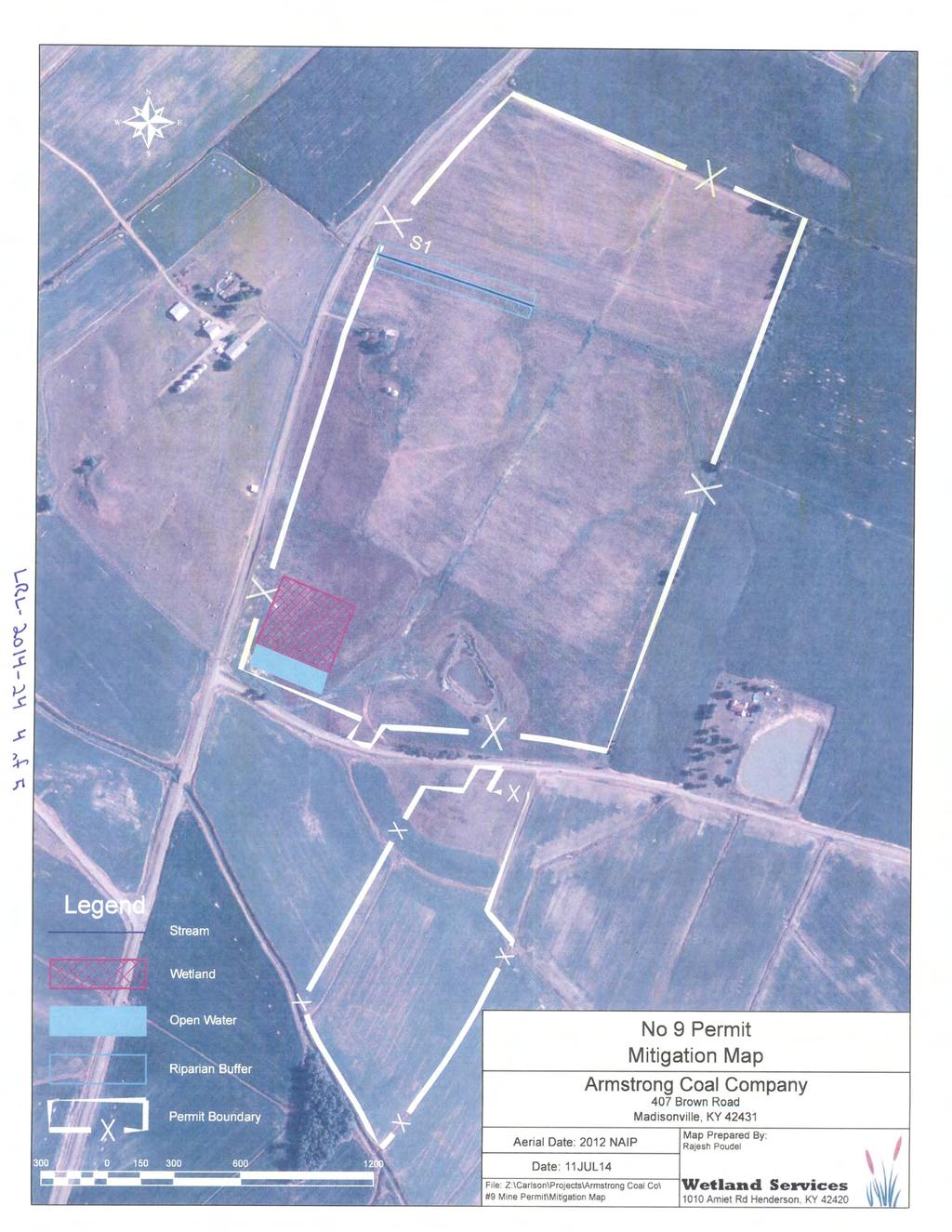
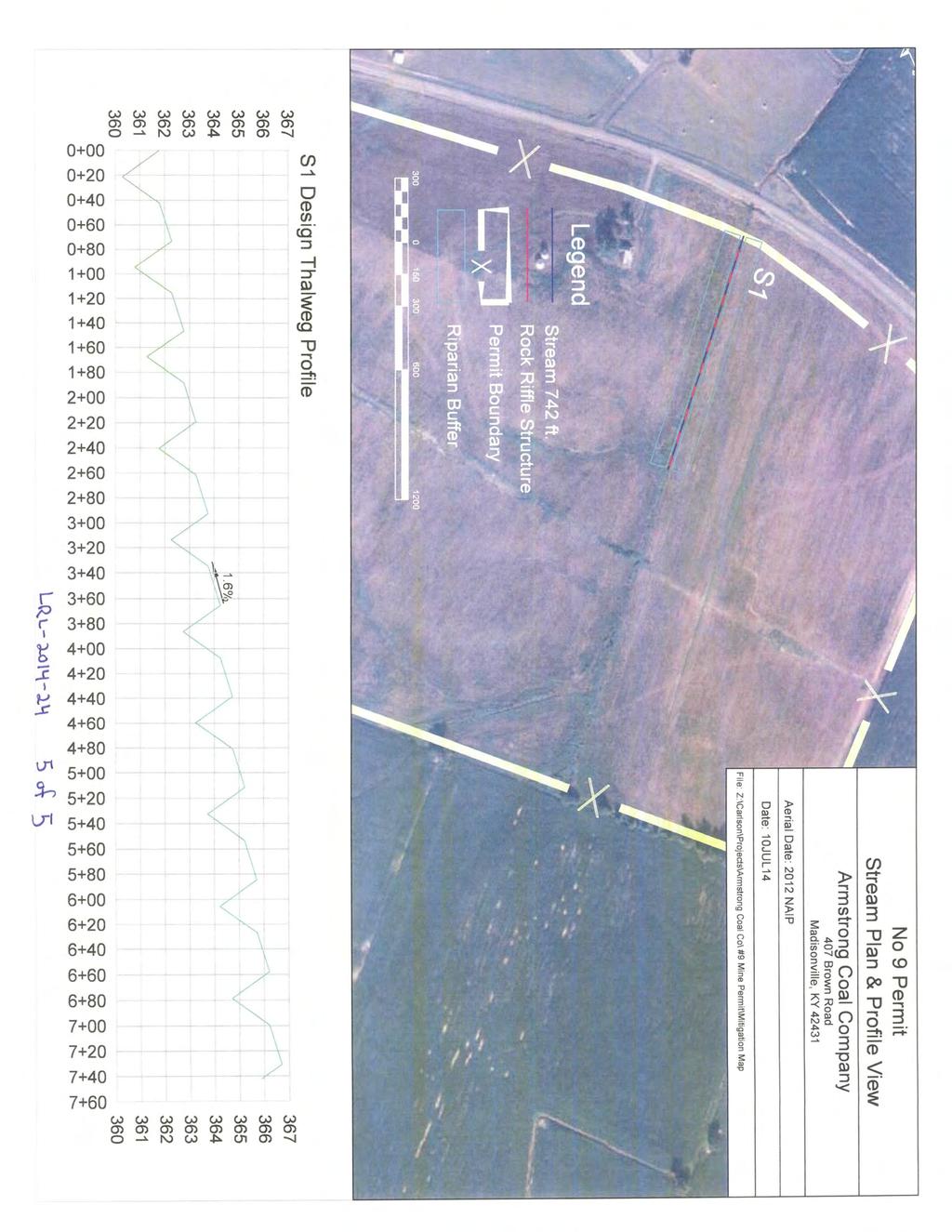
2 Operations Division Regulatory Branch (West) Public Notice No. LRL mad Streams, wetlands, and open water would be impacted from the construction of the underground mine and associated surface facilities. A total of 742 linear feet of intermittent stream (4AS1) would be impacted. Materials to be discharged into the stream include fill material needed to create a levee around a sediment basin, two 100 ft high-density polyethylene (HDPE) pipe culverts, and necessary backfill to set the culverts in place for the stream crossing. Additionally, 1.7 acres Palustrine Emergent Wetland (PEM) and 0.6 acre of open water would be impacted by surface facilities. Materials to be discharged into the wetland and open water would include a gravel access road, backfill created from the road construction, and land surface reshaping necessary to facilitate site drainage and construction of a parking lot and supply yard. AVOIDANCE, MINIMIZATION, AND MITIGATION MEASURES: The applicant has attempted to avoid and minimize impacts to jurisdictional Waters of the United States (U.S.). The applicant proposes avoidance of direct impacts to 1,010 linear feet of intermittent and 2,661 linear feet of ephemeral streams found within the project boundary. The applicant has chosen to avoid these streams and wetlands to reduce impacts to potential waters of the U.S. The design for the underground mine and surface facilities include the use of best management practices, reclamation, and mitigation to compensate for direct impacts. Stream and open water mitigation would be accomplished as permittee responsible on-site and in-kind mitigation, while wetland impacts would be mitigated on-site and outof-kind. It is proposed that the intermittent stream would be mitigated at a 1:1 ratio, for a total 742 linear feet of intermittent stream restored on-site. The mitigation would involve the restoration of the lower reach of intermittent stream (4AS1). The stream mitigation would be completed when Armstrong receives approval to remove the sediment basin. At that time, stream mitigation shall occur beginning at the permit boundary and proceeding upstream 742-ft. The restored stream would have similar drainage patterns and connectivity as existing conditions. The proposed stream design is based on geomorphic and hydrologic principles incorporated with natural channel design techniques utilizing in-stream structures for habitat diversity and stream bank protection. Stream morphology was determined by using regional curve data, collecting and studying data from existing streams, sediment transportation and hydrologic calculations. Through a series of rapids and scour pools, stream energy would be dissipated and channel stability maintained. Proposed stream substrate would range from silt/clay to small cobble. A diverse 50 foot forested riparian buffer would be established along each side of the intermittent mitigation stream reach. 2
3 Operations Division Regulatory Branch (West) Public Notice No. LRL mad Open water would be mitigated in-kind on-site in the form of the southwest basin which would be at least 0.6 acre. It is proposed that unavoidable impacts to the PEM wetland would be mitigated out-of-kind at a 1.5:1 ratio through the creation of 2.6 acres of Palustrine Forested Wetland (PFO). The proposed location for the mitigation wetland is adjacent to the southwest basin approximately 0.5 ft above the elevation of the spillway. The wetland area would be graded flat to temporarily hold water and ensure adequate hydrology to support a PFO wetland type. The southwest basin is not a typical mining basin, and would not receive refuse or deposits of high sediments loads. The applicant would be able to control the elevation and form the basin and wetland in a manner suitable to establish and maintain appropriate hydrology. Grading and herbaceous planting would be conducted after construction is complete. Existing wetland soils would be excavated and stockpiled to be used for the establishment of the mitigation wetland. Tree planting would consist of a diverse selection of hard mast species. Following site construction and watershed stabilization, all wetland and open water mitigation would be completed. This would allow the construction of the mitigation wetland concurrently with project development as the area is mostly outside the construction area, thus minimizing temporal loss. It is noted that this proposed mitigation plan is open to comment and subject to change. The Corps will make a determination of appropriate mitigation, upon review of all submitted information. REVIEW PROCEDURES: A DA Permit cannot be issued if any legally required Federal, State, or local authorization or certification is denied. A DA permit, if otherwise warranted, will not be issued until a State of Kentucky Water Quality Certification or waiver is on file at this office. In order to comply with Section 401 of the Clean Water Act, the applicant must apply for State certification from the Kentucky Energy and Environment Cabinet Division of Water (KDOW). Copies of this notice are sent to the appropriate Federal and State Fish and Wildlife Agencies. Their views and comments are solicited in accordance with the Fish and Wildlife Coordination Act of Based on available information, the proposed activity will not destroy or endanger any Federally-listed threatened or endangered species or their critical habitats, as identified under the Endangered Species Act, and therefore, initiation of formal consultation procedures with the U.S. Fish and Wildlife Service is not planned at this time. Any person may request, in writing, within the comment period specified in this notice, that a public hearing be held to consider this application. A request for a public hearing must state the specific interest which might be damaged by issuance of the DA Permit. 3
4 Operations Division Regulatory Branch (West) Public Notice No. LRL mad The National Register of Historic Places has been examined, and it has been determined that there are no properties currently listed on the Register which would be directly affected by the proposed work. If we are made aware, as a result of comments received in response to this notice, or by other means, of specific archaeological, scientific, prehistorical, or historical sites or structures which might be affected by the proposed work, the District Engineer will immediately take the appropriate action necessary pursuant to the National Historic Preservation Act of Public Law as amended (including Public Law ). The decision whether to issue a permit will be based on an evaluation of the probable impact of the proposed activity on the public interest. That decision will reflect the national concern for both protection and utilization of important resources. The benefits which reasonably may be expected to accrue from the proposal must be balanced against its reasonably foreseeable detriments. All factors which may be relevant to the proposal will be considered; among those are conservation, economics, aesthetic values, general environmental concerns, historic values, fish and wildlife values, flood damage prevention, land use, navigation, recreation, water supply, water quality, energy needs, safety, food production, and in general, the needs and welfare of the public. In addition, the evaluation of the impact of the activity on the public interest will include application of the guidelines (40 CFR Part 230) promulgated by the Administrator, United States Environmental Protection Agency, under authority of Section 404(b) of the CWA. The Corps of Engineers is soliciting comments from the public; Federal, State, and local agencies and officials; Indian tribes; and other interested parties in order to consider and evaluate the impacts of this proposed activity. It is presumed that all interested parties and agencies will wish to respond; therefore, a lack of response will be interpreted as meaning that there is no objection to the proposed project. Any comments received will be considered by the Corps of Engineers to determine whether to issue, modify, condition or deny a permit for this proposal. To make this decision, comments are used to assess impacts on endangered species, historic properties, water quality, general environmental effects, and the other public interest factors listed above. Comments are used in the preparation of an Environmental Assessment and/or an Environmental Impact Statement pursuant to the National Environmental Policy Act. Comments are also used to determine the need for a public hearing and to determine the overall public interest of the proposed activity. Written statements received in this office on or before the closing date will become a part of the official record and will be considered in the determination on this permit request. Any objections which are received during this period will be forwarded to the applicant for possible resolution before the determination is made whether to issue 4
5 Operations Division Regulatory Branch (West) Public Notice No. LRL mad or deny the requested DA Permit. A permit will be granted unless its issuance is found to be contrary to the public interest. Information pertaining to this application is available for public examination during normal business hours upon prior request. Drawings are available on Louisville District's Internet site at All comments regarding this proposal should be addressed to Mr. Matt Dennis; CELRL- OP-FW at the address noted above and should refer to the Public Notice Number LRL mad. If you desire to submit your comments by , you must comply with the following: a) In the subject line of your , type in ONLY the Public Notice ID No. LRL mad. Example: Subject: LRL mad b) Provide your physical mailing address and telephone number. c) Send your to: lrl.regulatorypubliccomment@usace.army.mil. d) If you are sending attachments greater than 1 Mb in size with your , you must send a hard copy (CD or paper) to the Corps physical address as well. 5
6
7
8
9
10