Lots 1 & 8, 315 Dutton Way and Lot 2 Princes Highway Bolwarra. Application for works Approval Abalone Farm
|
|
|
- Terence Richards
- 5 years ago
- Views:
Transcription
1
: Property Address: Cadastral: Lots 1 & 8 Development Description: GHCMA-W-2018-00285 Lots 1 & 8, 315 Dutton Way and Lot 2 Princes Highway Bolwarra.")
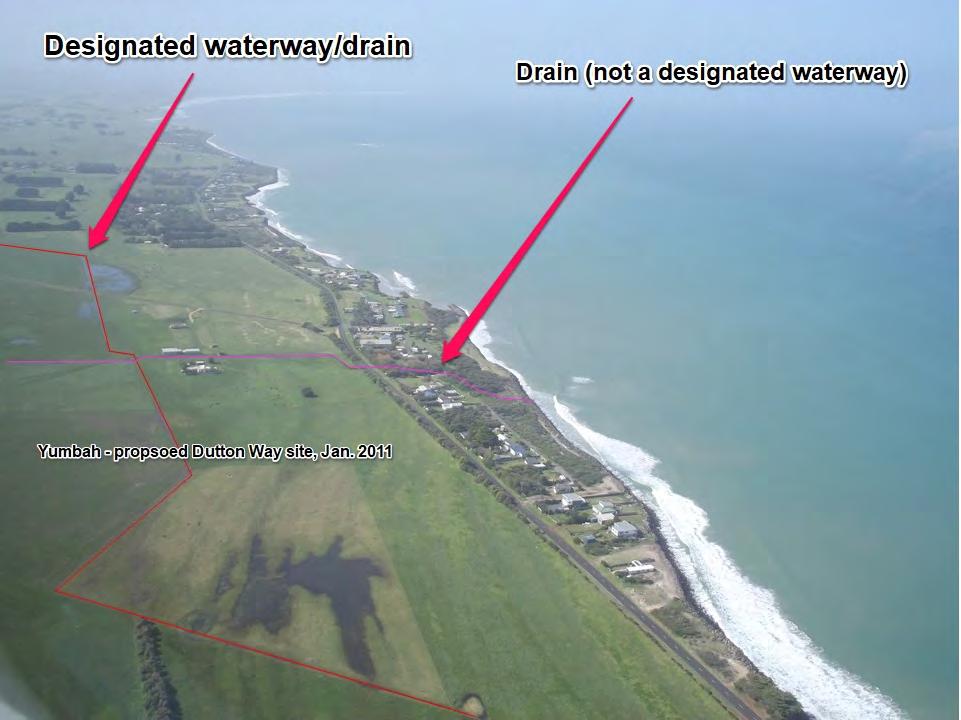
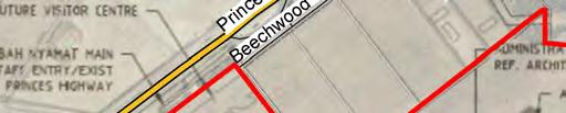
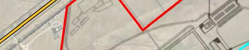
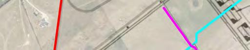
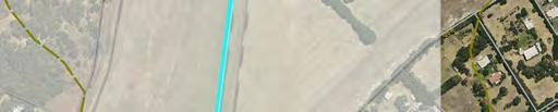
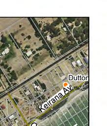
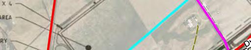
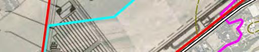
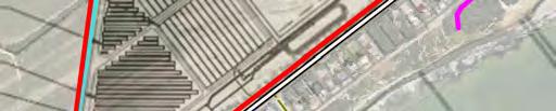
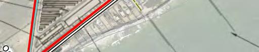
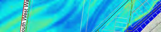
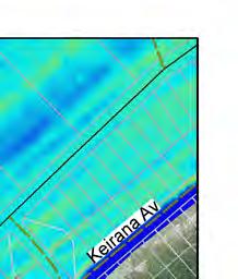
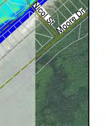
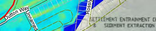
2 Your Ref: Date: 21 December 2018 Document No: 1 Rachel Manassa, Project Officer, Development Assessments EPA Victoria 200 VICTORIA Street CARLTON VIC 3053 Dear Rachel, Application Number (CMA Ref): Property Address: Cadastral: Lots 1 & 8 Development Description: GHCMA-W Lots 1 & 8, 315 Dutton Way and Lot 2 Princes Highway Bolwarra. Application for works Approval Abalone Farm Thank you for your referral received at our office on 28 November Whilst the CMA is a stakeholder in this issue it must be noted that the CMA is not the responsible authority for regulation of water quality or biosecurity impacts. The following response therefore relates solely to the matters relating to the CMAs statutory responsibilities with regard to the development, namely potential impacts of the development on inland waterways and flood risks associated with the development site. Waterway impacts. As shown on the attached Plan A, the site for the proposed development is bisected by 2 substantial waterways. One of these runs from north east to south west across the site and is a designated waterway within the Glenelg Hopkins CMAs gazetted waterway management district (see blue line on Plan A). Any works affecting the bed and/or banks of this waterway, including any new drainage outfalls require a Works on Waterways Licence from Glenelg Hopkins CMA. This is a low value waterway from a natural values perspective, being a man-made drain constructed in historical times for the purpose of draining the back-dune wetland system extending from Narrawong through to Dutton Way. The CMA has no data with regard to the flow conveyance capacity of this waterway/drain however aerial photography of the proposed development site taken in January 2011 (attached) indicates that the drain system may convey substantial volumes of water in wet years. The drainage function of the designated waterway described above is further augmented by a cross drain (see pink line on Plan A) which runs in a northwest to southeast direction again through the centre of the proposed development area. This second waterway/drain is not a designated waterway and therefore works affecting it do not require statutory approval from the CMA. The alignment of both waterways (drains) is clearly evident on the CMAs Digital Elevation Model mapping shown on Plan B and the attached 2011 aerial photograph. Glenelg Hopkins Catchment Management Authority Statutory Water Group A: PO Box 502, Hamilton Vic 3300 T: F: E: planning@ghcma.vic.gov.au W:
3 Irrespective of the need for the developer to obtain a Works on Waterway licence for any proposed works affecting a designated waterway, there is a clear need for consideration of appropriate management of surface water flows across the proposed development site. This matter has not been addressed by the Works Approval Application but will need to be addressed in an application for a Works on Waterways Licence from Glenelg Hopkins CMA. The CMAs understanding is that earthworks which change the rate of flow or the discharge point of water across a property boundary require a planning permit issued by Glenelg Shire, as per the Schedule to the Glenelg Planning Schemes Rural Living Zone. Potential Flood Impacts As indicated by the above mentioned 2011 aerial photo of the development site, the low lying nature of the topography and the presence of substantial drains, it is considered that the proposed development site is subject to waterlogging and potentially periods of inundation by catchment runoff in wet years. In addition, given the low-lying topography and proximity to the southern ocean, there is potential for the site to be affected by large storm tide flood events. Insufficient information currently exists to enable characterisation of the level of risk posed by storm tide flooding of the site both now and into the future. Recognition and consideration of this risk is also lacking in the submitted Works Approval Application. In closing, it is submitted that the above matters related to surface water management and flood risk should be addressed prior to the granting of Works Approval for this development. Contact should you have any queries. Please quote GHCMA- W to assist the CMA in handling your enquiry. Yours sincerely, The information contained in this correspondence is subject to the disclaimers and definitions below. Definitions and Disclaimers 1. The area referred to in this letter as the property is the land parcel(s) that, according to the CMA s assessment, most closely represent(s) the location identified by the applicant. The identification of the property on the CMA s GIS has been done in good faith and in accordance with the information given to the CMA by the applicant(s) and/or relevant local government authority. 2. While every endeavour has been made by the CMA to identify the proposed development location on its GIS using VicMap Parcel and Address data, the CMA accepts no responsibility for or makes no warranty with regard to the accuracy or naming of this proposed development location according to its official land title description. 3. No warranty is made as to the accuracy or liability of any studies, estimates, calculations, opinions, conclusions, recommendations (which may change without notice) or other information contained in this letter and, to the maximum extent permitted by law, the CMA disclaims all liability and responsibility for any direct or indirect loss or damage which may be suffered by any recipient or other person through relying on anything contained in or omitted from this letter. Glenelg Hopkins Catchment Management Authority Statutory Water Group A: PO Box 502, Hamilton Vic 3300 T: F: E: planning@ghcma.vic.gov.au W:
4 4. This letter has been prepared for the sole use by the party to whom it is addressed and no responsibility is accepted by the CMA with regard to any third party use of the whole or of any part of its contents. Neither the whole nor any part of this letter or any reference thereto may be included in any document, circular or statement without the CMA s written approval of the form and context in which it would appear. 5. The flood information provided represents the best estimates based on currently available information. This information is subject to change as new information becomes available and as further studies are carried out. 6. 1%AEP Flood A flood of this magnitude has a 1% chance of occurring in any given year. However a flood of this magnitude (or greater) may occur more frequently than once in any year. The 1% AEP flood extent is the minimum standard for land use and development planning decisions in Victoria (the planned for flood level). There is always a possibility that floods larger in height and extent than the 1% AEP flood may occur in the future. The 1% AEP flood is not the probable maximum flood (PMF). 7. AEP as Annual Exceedance Probability is expressed as a percentage (%) risk. 8. PMF as Probable Maximum Flood is the largest conceivable flood for a location 9. AHD as Australian Height Datum is the adopted national height datum that generally relates to height above mean sea level. Elevation is in metres. 10. Freeboard is a height allowance above a flood level. In the context of planning for development of flood-prone land, freeboard is applied to ensure floors are finished at a level above the estimated flood level. This lowers the risk of over-floor flooding due to floods bigger than the 1%AEP event and due to uncertainties in estimation of the planned for flood level. Uncertainties include factors such as the effect of waves caused by wind or the effect of vehicles moving through a flooded area, or the impact of rising mean sea level. 11. Nominal Flood Protection Level (NFPL) is the 1%AEP flood level plus a freeboard (height) allowance to provide increased protection against flooding. It is generally the minimum floor level for habitable spaces and the level below which no electrical outlets or sewer openings are permitted. Glenelg Hopkins Catchment Management Authority Statutory Water Group A: PO Box 502, Hamilton Vic 3300 T: F: E: planning@ghcma.vic.gov.au W:
5


6


7


8 28 November 2018 Richard Hook Senior Project Manager Development Assessment Unit EPA Victoria PO Box 4395 Melbourne VIC 3001 Dear Richard APPLICATION FOR WORKS APPROVAL Thank you for your letter dated 31 October 2018 regarding the Yumbah Aquaculture Limited. As discussed on the phone with you, this is the first time that our corporation has received an EPA notice. Information regarding the EPA was distributed to our members who are Gunditjmara traditional owners and native title holders with a request to provide their comments on the EPA notice regarding the proposed aquaculture facility at Dutton Way and Bolwarra. The comments received from the Gunditjmara community included the following concerns and questions: Dutton Way is classified as a rural living zone and the impact of the proposed facilities will affect the liveability of Gunditjmara living at Dutton Way. Why does the company locate its other aquaculture facilities in isolated areas while proposed to locate its proposed facility at Dutton Way and Bolwarra near homes where Gunditjmara live and reside? The water table at Dutton Way and Bolwarra is extremely close to the surface and Gunditjmara living at Dutton Way rely on groundwater. The Glenelg Shire Council had recently enforced Gunditjmara residents at Dutton Way to install sewage systems a few years ago to address the risk of contamination. What will be the impact of the proposed aquaculture facility and its operations on the groundwater at Dutton Way and Bolwarra? Given the massive size of the proposed aquaculture facility, what tests have been done to replicate the noise and vibration levels of such a large operation? What tests have been done to assess the potential impact of the noise and vibration on homes and surrounding lands? Is there any comparable data from an equally large operation? Continuing Connection to Country
9 Given the current smells and odours experienced at the Narrawong facility and the huge increase in size of the proposed farm, what test have been done to assess to the level of odours and the potential impact on surrounding residents? Why are we (as Gunditjmara) paying rates for? Where is the protection of our amenity? Has the council considered what impact Yumbah will have on land and home values for our community? Will there be compensation for negative financial outcomes for homeowners if Yumbah gets approval? Has there been any study on the impact on the burrowing crayfish and other resident wildlife? What testing has been done on the pipe noise and vibration to the breeding whales that visit Dutton Way? Has there been testing done in accordance with the size of the proposed facility? What testing has been done to measure the potential impact of the discharge back into the sea, of such an unprecedented size development and output of water, warmth and nutrients? What studies have been done or what comparisons have been made to assess the impact of such a huge farm on the surrounding environment? How can Yumbah verify its claims of meeting all noise and EPA standards when there is no comparative facility? As an Aboriginal person who has purchased her home on country I have a strong desire to continue my cultural connection to these ancestral grounds. My home is my sanctuary and offers me a direct connection to my land. I have borne witness to the inter-generational trauma my family goes through, in the form of drugs, alcohol, suicide and the dysfunction caused by many years of colonisation and forced removal of children from their family and people from their country. Owning my home on country is an opportunity for me to share my sanctuary and offer respite for those family members that need to rest and to rediscover their connection to their homeland for their spiritual health and well-being, away from local politics and extended family. A spiritual and physical healing place without bureaucratic red tape. Please note that our corporation is working with DPC Aboriginal Victoria on the development of the Cultural Heritage Management Plan under the Aboriginal Heritage Act If you require further information, please contact the GMTOAC office on Page 2 of 2

10 Friends of the Great South West Walk Inc A F PO Box 192 Portland Vic th September 2018 Mr Tim Rudge General Manager Yumbah Narrawong Portland Vic 3305 Dear Tim On behalf of the President, Lou Florakx and committee of the Friends of the Great South West Walk thank you for your presentation on 12 September 2018 to our committee outlining Yumbah s development plans for Lots1 8/315 Dutton Way and Lot 2 Princess Highway Bolwarra. Our committee considered the comprehensive outline of the project from yourself and Emma of the benefits of the project to the community of Portland including the enhancement of the Great South West Walk and resolved to support the proposal subject to approval from all relevant authorities and consistent with the Glenelg Shires Management plans. Matters positively considered to enhance the Great South West Walk were landscaping and interpretative signage along the current route to enhance walker experience and complement the local environment. Our committee welcomes the opportunity to discuss further enhancements to the Great South West Walk and advancement of the project as opportunities arise. Once again thank you for the presentation and opportunity to discuss this project to our mutual benefit. Yours faithfully

11 DF Folder: DF2018/00111 In reply please quote: D2018/ November 2018 Rachel Manassa Project Officer Works Approval Development Assessments Unit EPA Victoria 200 Victoria Street Carlton 3053 Dear Rachel, RE: APPLICATION FOR WORKS APPROVAL Application: Address: Use and Development of Land for an Aquaculture Facility, Associated Buildings and Works Lots 1 & 8, 315 Dutton Way & Lot 2 Princes Highway Bolwarra I refer to your letter received regarding the above application. Wannon Water is aware of this proposal. The proposal has been examined with regard to water and sewerage servicing requirements and Wannon Water does not object to the granting of the works approval providing the application is subject to the following conditions: 1. The provision, at the developers cost, of the required sewerage works necessary to serve the proposed development. The works are to be constructed and acceptance tested under the supervision of a consulting engineer in accordance with the plans and specifications approved by Wannon Water. 2. The provision, at the developers cost, of the required water supply works necessary to serve the proposed development. The works are to be constructed and acceptance tested under the supervision of a consulting engineer in accordance with the plans and specifications approved by Wannon Water. 3. The developer entering into an agreement with Wannon Water for payment of the new customer contributions applicable to the proposed development. 4. The developer obtaining the necessary consents and approvals for: - Alteration to or connection of on-site plumbing. The discharge of trade waste (other than domestic sewage) from the property. For Information Please note Wannon Water will require further detailed information on the proposed water supply, water connection, expected sewer discharge volumes ( including trade waste ) to determine what Wannon Water s requirements will be for the proposed development.
12 - 2 - If you require any additional information please contact on [1300 WANNON]. Yours faithfully,