A Decision Support System for Water Management
|
|
|
- Alexina Murphy
- 5 years ago
- Views:
Transcription
 Wolfer, J., Huber, M. & Hennings, V. (BGR) ARAB GERMAN TECHNICAL COOPERATION")
1 A Decision Support System for Water Management Droubi, A., Al-Sibai, M., Abdallah, A., Mahamed, J., Shahabi, O., Zahra, S. & Obeissi, M. (ACSAD) Wolfer, J., Huber, M. & Hennings, V. (BGR) ARAB GERMAN TECHNICAL COOPERATION
, Damascus, SYRIA www.acsad.org, www.acsad-bgr.org and the Federal Institute for Geosciences and Natural Resources (BGR), Hannover, GERMANY www.bgr.de, www.acsad-bgr.org Funded by the German Federal Ministry for Economic Cooperation and Development, www.")
2 Technical Cooperation Project: Management, Protection and Sustainable Use of Groundwater and Soil Resources in the Arab Region between the Arab Centre for the Studies of Arid Zones and Dry Lands (ACSAD), Damascus, SYRIA and the Federal Institute for Geosciences and Natural Resources (BGR), Hannover, GERMANY Funded by the German Federal Ministry for Economic Cooperation and Development,
3 What s new? NEW project phase 08/ /2011 NEW tool Modflow2Weap to link WEAP and MODFLOW NEW WEAP-functions NEW Tutorial on how to link WEAP and MODFLOW Integration of a NEW internal model in WEAP to calculate surface runoff, irrigation demand, irrigation scheduling and groundwater recharge NEW reports & publications WEAP user conference , Damascus, SYRIA NEW documentations in French (standard tutorial, WEAP- MODFLOW tutorial) aral_amo_ _250m_geo.tif Image date
4 NEW project phase 08/ /2011 Further DSS-dissemination and institutionalizing -> ACSAD-BGR project s main focus, Training workshops, WEAPuser-meetings, networking etc. -> finally decisions are made and enforced by respective water instituions based on the DSS results (fairly accurate water balances -> allocation, limits, protection, ) Incorporation of a more process-based soil water balance model into WEAP (MABIA) to calculate groundwater recharge and irrigation demands Manual for calibrating groundwater recharge and irrigation demand with respective WEAP-models. Regional recharge database Icorporation of optimization options (genetic algorithm) Incorporation of socio-economic aspects, GW-transport


5 DSS Training Workshop Tunisia introduction into WEAP-MODFLOW in March 2009 another workshop will be held to couple 5 local models with WEAP and apply them in the respective instututions in cooperation with the local GTZ project & INAT


6 NEW Tool to link MODFLOW and WEAP (Modflow2Weap) free download from 1. Create linkshapefile and read out MODFLOW inputs load Modflow model (.mfn/.nam) select packages to be read view Modflow Info select output options (shp/ dbf) select normalization option
7 OUTPUT 1 SPREADSHEET Column Header Type of Data sample data MF_Row Row-Number 5 MF_Col Column-Number 60 MF_RC Combined Row-Column-Numbers BND_L1 Boundary cond. of layer 1 1 to BND_Ln Boundary cond. of layer n 1 STD_L1 Starting head of layer to STD_Ln Starting head of layer n WEL_SP1 Well-Abstraction at stress period to WEL_SPn Well-Abstraction at stress period n DRN Drain cell yes/no (0 or 1) 0 RCH_SP1 Recharge-height at stress period to RCH_SPn Recharge-height at stress period n RIV River cell yes/no (0 or 1) 0 SHAPEFILE Column Header Type of Data sample data CATCHMENT The name of a WEAP-catchment Empty (by default) LANDUSE The name of a WEAP-land class Empty (by default) GROUNDWAT The name of a WEAP-GW node Empty (by default) RIVER The name of a river reach Empty (by default) DEMAND1 The name of a WEAP-demand site Empty (by default) DEMAND2 The name of a WEAP-demand site Empty (by default) AREA_M2 The cell s area in m² AREA_HA The cell s area in ha


8 NEW Tool to link MODFLOW and WEAP (Modflow2Weap) free download from 2. Create WEAP input files & GIS background layers for WEAP load Modflow model (.mfn/.nam) load linkshape-file (.shp) specify output folder select WEAP functions results as.csv-files, which can be read in by WEAP Year, Time Step, Value1, Value2,... select GIS functions results as shp-files, which can be loaded as background layers
9 OUTPUT 2 GIS FUNCTIONS Function Resulting geometry Required assignment in the linkage shapefile Outline The outer boundary of the model s active cells None Catchment One (multi-) polygon for each catchment Catchment names Landuse One (multi-) polygon for each landuse class inside a catchment s area Catchment names and landuse classes Wells One polygon for each set of connected well-cells None WellDemand Rivers One (multi-) polygon for each set of wells defined for each Demand site One polygon for each set of connected rivercells Demand sites None Riverreaches One polygon for each riverreach River reaches names Drains Recharge One polygon for each set of connected draincells One (multi-) polygon for each set of connected cells having an equal recharge-rate None None


10 , NEW WEAP functions: PumpLayer Demand Site Catchment if irrigation is modelled
11 MODFLOW Link Technical Details DOCUMENTATION (WEAP-HELP-FILE) When properly linked, data and results flow back and forth between WEAP and MODFLOW for each calculation timestep. The following description provides details of exactly what information is passed between WEAP and MODFLOW, and how the process happens. WEAP reads information from the MODFLOW packages before calculations begin, along with the linkage information that links MODFLOW cells to WEAP objects. Thereafter, at each calculation timestep, WEAP will write out a new set of MODFLOW package files, run MODFLOW, then read the results from the MODFLOW output files. (If you select the option to save all MODFLOW input and output files, the new MODFLOW package files created will be named with!mf! as a prefix and a suffix unique for each scenario, year and timestep. For example, if the original Recharge filename is Zabadani.rch, the new Recharge file written for the Current Accounts (scenario number 1) for March 2000 would be!mf!zabadani_s01_2000_03.rch. This allows you to inspect or modify the input files and rerun MODFLOW yourself, outside of WEAP. This could be an aid in debugging. However, keep in mind that all these files will be deleted and recreated the next time WEAP calculates results.) A MODFLOW model consists of many different "packages," most of which are optional. However, not all packages are used or allowed by WEAP. Used by WEAP: BAS6 (Basic), BCF6 (Block-Centered Flow), CHD (Constant-Head), DIS (Discretization), DRN (Drain), HUF2 (Hydrogeologic Unit Flow), LPF (Layer Property Flow), NAM (Name), OC (Output Control), RCH (Recharge), RIV (River), WEL (Well). WEAP reads information from each of these, and will write new versions of each with changes, as explained below. (The original files will not be changed.) WEAP only requires NAM, DIS, BAS6 and one of BCF6/HUF2/LPF--all other packages are optional. Allowed but not used by WEAP: ADV2 (Advective-Transport Observation), DE4 (Direct Solution), DRT (Drain Return), ETS (Evapotranspiration Segments), GAGE, GHB (Ground-Water Flow Process General-Head Boundary), HFB6 (Ground-Water Flow Process Horizontal Flow Barrier), HYD (HYDMOD), IBS (Interbed-Storage), KDEP (Hydraulic-Conductivity Depth-Dependence Capability of the HUF2), LMG (Link-AMG), LVDA (Model-Layer Variable-Direction Horizontal Anisotropy capability of the HUF2), MNW1 (Multi-Node, Drawdown-Limited Well), MULT (multiplier), PCG (Preconditioned Conjugate-Gradient), RES (Reservoir), SIP (Strongly Implicit Procedure), SOR (Slice-Successive Over-Relaxation), SUB (Subsidence and Aquifer-System Compaction), ZONE. Commented out in new name file: (Observation files might reference stress periods after the first, which no longer exist) CHOB (Constant-Head Flow Observation), DROB (Drain Observation), DTOB Drain Return Observation), GBOB (General-Head-Boundary Observation), HOB (Head-Observation), OBS (Observation Process), RVOB (River Observation), STOB (Streamflow-Routing Observation), LMT6 (Link-MT3DMS) Not allowed: ASP, DAF (DAFLOW surface-water), DAFG (DAFLOW ground-water), LAK (Lake), EVT (Evapotranspiration). FHB (Flow and Head Boundary), PES (Parameter Estimation), SEN (Sensitivity Process), STR (Streamflow-Routing).
12 NEW Tutorial on how to link WEAP to MODFLOW and how to create typical scenarios free download from

13 NEW WEAP-Tutorial and WEAP-MODFLOW Tutorial in FRENCH free download from and WEAP has a built in FRENCH user interface

 FAO, IRRIGATION DEMAND ONLY 3) FAO")

")
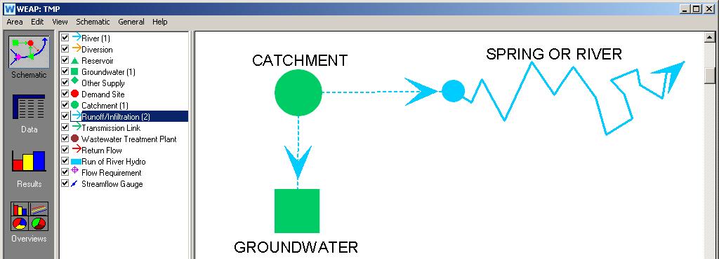
14 WATER EVALUATION & PLANNING SYSTEM - GW-RECHARGE/IRRIGATION DEMAND AND SURFACE RUNOFF CALCULATIONS IN WEAP: 1) ENTER AS HARD DATA 2) FAO, IRRIGATION DEMAND ONLY 3) FAO RAINFALL-RUNOFF MODEL (ETref, Kc) 4) SOIL MOISTURE MODEL (soil, plant & climate parameters) wellfields artificial recharge 5) MABIA MODEL (soil, plant & climate parameters) QUAL2K MODEL MODFLOW MODEL


15


16


17


18


19


20

21


22


23
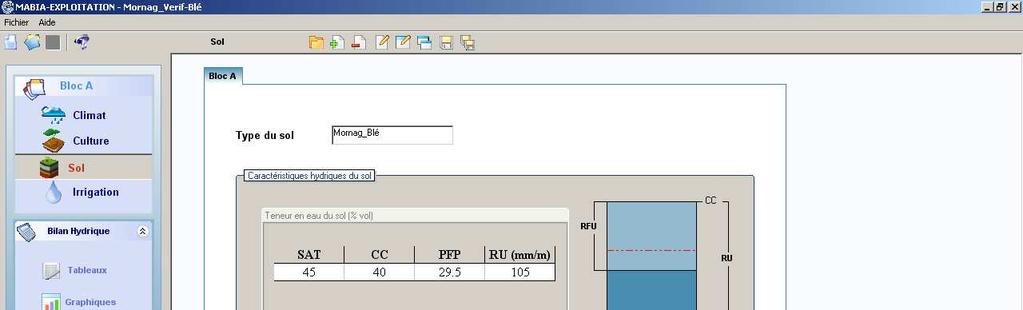
24 , M A B I A for details and a compiled version contact: sahli_inat_tn@yahoo.fr Powerful stand alone tool, french interface & documentation Integration of the MABIA algorythm by 05/2009 into WEAP Incorporation of the Crop Yield Reduction (Crop Yield response factor - according FAO paper 33) Data pre-processing to generate daily data if not available MABIA has a daily time step, but WEAP can have a monthly time step (aggregation/ disaggregation functions)


25 NEW REPORTS & PUBLICATIONS Project Reports (7/2008) SPRINGER PUBLICATION (4/2008)
26 Sponsors/ Organizers Arab-German Cooperation Sponsored by: German Federal Ministry for Economic Cooperation and Development United Nations Educational, Scientific and Educational Organization Regional Office, Cairo, EGYPT United Nations Environment Program Regional Office for West Asia (ROWA) Manama, BAHRAIN Stockholm Environment Institute Organized by: The Arab Center for the Studies of Arid Zones and Dry Lands (ACSAD) Contact: Dr. Abdallah Droubi Director Water Department Tel./Fax: / 3063 German Federal Institute for Geosciences and Natural Resources (BGR) Contact: Johannes Wolfer ACSAD-BGR Project Coordinator j.wolfer@bgr.de Arab-German Cooperation Regional Conference: ACSAD-BGR Cooperation ACSAD and BGR have been jointly working in various cooperation projects since more than two decades. The project Management, Protection and Sustainable Use of Groundwater and Soil Resources has been launched in April Applying WEAP as a Decision Support System (DSS) for IWRM May 2009 Damascus, SYRIA After developing and testing a user-friendly, efficient, inexpensive and easily sharable instrument for water management (Decision Support System, DSS) in the previous phase, the main objective of Phase IV (08/ /2011) is to distribute it with regard to a more integrated water resources management among the countries and the respective institutions of the Arab region. The application of a DSS for Soil and Groundwater Management will give decision makers the necessary insight into the current status and possible scenarios of the future development (e.g. population growth, climate change). Through visualizing and discussing the current status and future scenarios with the relevant stakeholders, jointly decided and accepted water shares can be fixed. This will reduce the conflict between concurrent water-users and will lead to a sustainable management of limited water resources for the current and future hydrologic years A report on the DSS-application of 2 pilot studies: Zabadani Basin, SYRIA Berrechid Basin, MOROCCO as well as other documentations (report on vulnerability mapping of the Zabadani Basin, DSShelper tools and Tutorial materials) can be downloaded from organized by The Arab Center for the Studies of Arid Zones and Dry Lands (ACSAD) & German Federal Institute for Geosciences and Natural Resources (BGR)
27 Conference Topics Background Dates WEAP applications in the field of: Water Planning Transboundary Water Policy Climate Change Studies Socio-economic Applications River Ecosystem Water Utilities Water Rights Administration Water Quality Safe Yield Analysis Multi Criteria Decision Analysis/ 0 Optimization Modeling Watershed Management Groundwater Recharge Modeling Irrigation Demand and Supply Modeling Groundwater Flow Model Integration 00(WEAP-MODFLOW-coupling) Reservoir Management Call for Papers till Water Resources are very scarce in the Arab region. Recent climate change models predict for the future years even more severe conditions, due to increasing temperatures and decreasing precipitation. Therefore it is important that water resources are managed carefully in a sustainable way following the IWRM concept. This is a very difficult task and reliable tools are needed to support the management and planning. In most countries of the region the key problem is the limited knowledge of the hydrological system and thus the water resources are not well evaluated. The impact of the limited knowledge and management of the resources is often overexploitation and water quality deterioration. ACSAD, BGR and SEI have jointly improved and applied such an IWRM-tool by combining WEAP and MODFLOW2000 water.usgs.gov/nrp/gwsoftware/modflow.html Various other institutions, researchers and projects have been applying WEAP as a Water Management and Planning tool in the region and beyond. The aim of the conference is to share this information between all interested people in the region and to start a user network to improve jointly the IWRM by applying and sharing powerful support tools like WEAP and respective experiences. The organizers are encouraging people from the region and beyond to present their case studies at the conference. Presentations will be 25 minutes, followed by 5 minutes discussion. The full papers need to be send in by Depending on the acceptance of the paper the organizers can sponsor the respective presenter by refunding travel and accommodation costs. Conference Dates: Deadline for Papers: Full papers need to be send in English as MS- Word or PDF-file via to water_dep@acsad.org and in CC to j.wolfer@bgr.de Acceptance of Papers: Application Deadline: Conference Cost: the conference itself will be free of charge. For presenters of accepted papers travel and accommodation expenses can be refunded by the organizers. Conference Venue: Damascus, SYRIA, exact address will be announced by April Conference Language: English Organizing Committee: Dr. Abdallah Droubi, ACSAD Johannes Wolfer, BGR Dr. Radwan Al-Weshah, UNESCO Dr. Ahmad Ali Ghosn, UNEP Dr. David Purkey, SEI Scientific Committee: Dr. Mahmoud Al Sibai, ACSAD Dr. Jihad Al Mahamid, ACSAD Johannes Wolfer, BGR Dr. Volker Hennings, BGR Jack Sieber, SEI
28

29
30

31

32 RESERVOIR