MEMORANDUM. Kathy Yager USEPA OSRTI Dick Goehlert USEPA Region 1 Darryl Luce USEPA Region 1 Mindy Vanderford, GSI Environmental, Inc.
|
|
|
- Eleanor Wood
- 5 years ago
- Views:
Transcription
1 MEMORANDUM To: From: Kathy Yager USEPA OSRTI Dick Goehlert USEPA Region 1 Darryl Luce USEPA Region 1 Mindy Vanderford, GSI Environmental, Inc. (GSI) Doug Sutton, GeoTrans, Inc. Rob Greenwald, GeoTrans, Inc Date: May 15, 2009 Subject: Summary/Update Regarding Site Conceptual Model Kearsarge Metallurgical Corporation Superfund Site, Conway, New Hampshire Introduction The purpose of this memo is to provide a condensed and updated summary of the site conceptual model for the groundwater contamination in the vicinity of the Kearsarge Metallurgical Corporation Superfund Site (the Kearsarge site or the Site ). The site is impacted by volatile organic compounds (VOCs), predominantly 1,1,1-trichloroethane (1,1,1-TCA) and 1,1-Dichloroethene (1,1- DCE), and to a lesser extent Trichloroethene (TCE). Figures from the Weston report Draft Final Post-Source Removal Data Evaluation Report (4/21/08) are included as Attachment A to this memo. These figures include a site plan, water level maps, and plume maps based on information collected through November GeoTrans was also provided with the Five-Year Review report (September 2008) as well as water level and water quality data collected subsequent to that Weston report (through August 2008). Therefore, the conceptual model update provided in this memo is based on data described in the Weston report dated 4/21/08, information provided in the Five-Year Review, and GeoTrans interpretation of data collected subsequent to those documents. This memo is intended to be used by Mindy Vanderford as a basis for performing optimization of long-term monitoring at the site. Hydrogeology and groundwater flow at the site are complex. The Site has historically been divided into two areas with different overburden geology, consisting of the Culvert Area (located on the eastern portion of the Site) and the Hobbs Street Area (located west of Hobbs Street on the western portion of the site). Both areas have been impacted by VOCs. Groundwater flow patterns and concentration trends have been further complicated by remedial activities that have included pumpand-treat (P&T) extraction and source area excavation. A brief summary of these activities is provided below. Fall 1993 P&T operation began Fall 2003 Source area excavation in the Culvert Area (to residual total VOC concentrations of approximately 3,000 μg/kg)
2 Early 2004 Culvert Area P&T extraction reconfigured to use only EW-13B within the excavation area (resulting in approximately double the flow of the previous Culvert Area system) February 2004 Hobbs Street Area P&T discontinued December 2005 Culvert Area P&T discontinued The locations of previous P&T extraction wells, and the location of the source area excavation, are illustrated on the figures in Attachment A. Specific components of the site conceptual model are detailed below. Relationship of Stratigraphy to Groundwater Flow Directions and Contaminant Transport A key feature of site stratigraphy is a silt layer with low permeability that is shallower on the eastern portion of the site than on the western portion of the site. The material above the silt is more transmissive (i.e., sands and gravels that coarsen to the west). The top of the silt is approximately 8 to 14 ft below ground surface (bgs) in the Culvert Area (i.e., the eastern portion of the site) but is more than 40 ft bgs in the Hobbs Street Area. This is illustrated on Figures 3 to 6 in Attachment B, which are cross-section figures created by Weston based on vertical profiling activities. The flow of groundwater appears to be controlled by variations in infiltration (i.e., no infiltration below the impermeable surfaces of the building), by areas of discharge, and by variations in the topography of the underlying silt. Groundwater flow is radially outward from the area of the previous excavation under current non-pumping conditions. To the east, groundwater discharges to a drain that ultimately discharges to Pequawket Pond. Flow of groundwater to the west and north may be due in part to mounding caused by the shallow silt layer in the eastern portion of the site. Potential discharge locations for water that flows to the north and west could include other portions of Pequawket Pond (i.e., to the northeast of the site and/or to the southwest of the site), and also perhaps to a river located north of the site and/or water supply wells CVD-1 and CVD-2 (operated by the Conway Village Fire District) that are located approximately 3,000 ft northwest of the Site. Historical water level maps from the 1990s consistently show a north/northwest component of groundwater flow in the western portion of the site. Figures 4 and 6 in Attachment B illustrate that, based on previous vertical profiling activities, the highest VOC concentrations have been observed at depth near the top of the silt. This is also illustrated in the immediate vicinity of the source area in Attachment C, which consists of Figures 6 and 7 from Appendix D of the Weston Report dated 4/21/08. Clean water from precipitation recharges the shallow groundwater, and as groundwater diverges from this area, relatively clean water remains in the upper portion of the sand, while more impacted to groundwater remains in or immediately above the silt. Variability in the top elevation of the silt (e.g., dipping, troughs, and valleys) likely plays a role in the direction of groundwater flow and the direction of contaminant transport. Groundwater flow (above the silt) to the east would be expected to be relatively fast compared to groundwater flow to the west. The aquifer is sand and the hydraulic gradient is steep. This is consistent with a thin aquifer that must accommodate recharge. Where the sand aquifer thickens to the west, the hydraulic gradient flattens due to the increased saturated thickness. Memorandum, 5/15/09, page 2
3 Changes in Water Level Patterns over Time Changes in the P&T remedy extraction have influenced groundwater flow patterns. As discussed in the Five-Year Review (September, 2008), after the excavation was completed extraction from existing extraction wells was discontinued and extraction well EW-13B was installed in the backfilled excavation (which served as an excavation trench), and pumping from EW-13B began in February 2004 and continued until December This resulted in inward flow towards EW-13B as illustrated on Figures 3 and 4 in Attachment A. Once pumping was discontinued in early December 2005, a ground water mound over the former excavation was established with radial flow away from the former excavation, as illustrated on Figures 6 to 8 in Attachment A. This is potentially significant with respect to contaminant transport. If the residual contamination left in place beyond the excavation is sufficiently strong, the residual contamination could potentially serve as a continuing source of dissolved contamination above cleanup standards in groundwater. Locations where water level data have been collected have changed over the years, and this has impacted water level interpretations. For example, since March 2006 water levels have not been collected near the pond, which results in changes in the interpreted potentiometric surface map. For instance, Figures 4 to 6 in Attachment A illustrate interpreted water level contours from Dec 2005 to March 2006, and they illustrate a component of flow to the south based on measured water level at MWS-201 (near the pond). However, Figures 7 to 10 in Attachment A illustrate interpreted water level contours from August 2006 to November 2007, and they do not illustrate this component of flow to the south. This change in interpretation appears to be due to the discontinued data collection at MWS-201 (near the pond) rather than an actual change in flow conditions. Groundwater flow patterns could potentially be influenced by water levels in Pequawket Pond. The Five-Year Review (September 2008) indicates that surface topography is generally flat, varying in elevation between 460 ft and 465 ft NGVD which is approximately 4 to 6 ft above the average water level of Pequawket Pond at the southern limit of the Site. The pond level is controlled by New Hampshire Water Resources Board via a downstream dam, and the Five-Year Review (September 2008) indicates that annual fluctuations up to 5 ft in the water level of the pond have been reported. However, the absence of water levels collected along the pond edge in the water level events illustrated in Attachment A makes it difficult to determine the extent to which changes in elevation of the pond might influence groundwater flow patterns. It is also noted that water levels are measured at very few wells west of Hobbs Street, leaving uncertainty in the groundwater flow pattern in this area. Contaminant Concentration Trends GeoTrans developed updated figures of concentration versus time for selected monitoring wells, listed below, with concentration data through August 2008: EW-13/EW-13B MWS-205 MW-7/MW-3008 (includes TCE) MW-3010 MW-211 (includes TCE) MW-3003 MW-5003 PZ-4002 Memorandum, 5/15/09, page 3
4 Those figures are included as Attachment D (note that some of these figures have the concentrations on logarithm scale, and others have the concentrations on linear scale). These wells were selected because they help illustrate the effects of the P&T and excavation remedies on contaminant transport at the site. EW-13 and replacement well EW-13B are located within the source area and historically exhibited high concentrations (e.g., 1,1,1-TCA approximately 10,000 ug/l through April 2003 and 4,000 ug/l through August 2003). In the fall of 2003 the source area was excavated and P&T was subsequently conducted from the backfilled trench using EW-13B as an extraction well. Concentrations of 1,1,1- TCA declined sharply by the next sample in January 2004 and continued to decline to below 10 ug/l. A similar trend is observed for 1,1-DCE. P&T was discontinued in December 2005 and concentrations remained low at EW-13B, presumably due to contamination removed from this area by the excavation. MWS-205 is approximately 100 ft north of the western portion of the source area, in an area where the underlying silt is shallow (approximately 14 feet bgs) and within the northerly groundwater flow path from this western portion of the source area (in the absence of remedy pumping). Concentration of 1,1,1-TCA was approximately 3,000 ug/l in 1992 and begin declining when P&T began in Fall 1993, and declines continued through April 2004 (after source area excavation and P&T modification). The P&T modification greatly increased the extent of the capture zone and modified groundwater flow directions in the area of MWS-205. Increases in the 1,1,1-TCA and 1,1-DCE concentrations through November 2005 (during pumping at EW-13B) are likely the result of pulling back contamination through the area of MWS-205 toward EW-13B or an otherwise similar change in the direction of contaminant transport caused by the remedy extraction. Concentrations of 1,1,1- TCA remained below the cleanup level of 200 ug/l, but concentrations of 1,1-DCE increased above the cleanup level of 7 ug/l. Concentrations then began decreasing again when P&T was discontinued in December 2005, such that concentrations of both 1,1,1-TCA and 1,1-DCE were below cleanup levels in the last two samples (June 2006 and August 2006). No samples have been collected from MWS-205 since August Given the observed trends, in the absence of pumping it is expected that future concentrations at this well would continue to decrease, or stabilize below cleanup levels. MW-7 (which was removed in 2003) and MW-3008 (which was installed in a similar location in 2005) are located east of the source area, along the drain where water discharges from the shallow sand aquifer. Concentrations were initially high (e.g., 1,1,1-TCA above 10,000 ug/l) but decreased immediately after P&T began in Concentrations then dropped and fluctuated (e.g., 1,1,1-TCA fluctuated between approximately 200 ug/l and non-detect) through The fluctuations were over a period that was approximately three to five years and did not appear to be seasonal. Given the proximity of MW-7 to an extraction well (EW-08), the fluctuations mostly likely resulted from variations in P&T extraction rates. Concentrations declined to non-detect when the source area P&T system underwent modification in Fall 2003, but concentrations have been slowly rising (as measured in MW-3008) since P&T was discontinued in ,1,1-TCA concentrations appear to plateau at a lower concentration (e.g., under 100 ug/l) than previous peaks during original P&T operation, but 1,1-DCE concentrations (about 100 ug/l) appear to be higher than previous peaks during original P&T operation. The recent concentrations of 1,1,1-TCA are below cleanup levels but the recent concentrations of 1,1-DCE are above cleanup levels. These recent concentrations may represent a new equilibrium based on residual contaminant mass beyond the excavation limits (which represents a reduced source term than previously existed, particularly for 1,1,1-TCA). MW-3010 is located northeast of the source area and was installed in early Results from this well indicated low or undetectable concentrations of 1,1,1-TCA and 1,1-DCE during operation of the Memorandum, 5/15/09, page 4
5 P&T system and then a timely increase in concentrations after P&T was discontinued in December Concentrations continued to rise or remain elevated for approximately one year and then decreased through early An increase was again noted in mid-2008 in MW-3010, but it is unclear if this trend will continue, level off, or will decrease. The concentration trend at MW-3010 is similar to that of MW-7/MW-3008 since early Because of their proximity to the source area they are good indicators of the concentration levels migrating from the eastern portion of the source area. History suggests that concentration trends at these two wells react quickly to P&T from EW- 13B if it is re-started. The currently observed concentrations may be representative of a new equilibrium based on reduced mass in the eastern portion of the source area. MW-211 is one of the furthest points to the west and is screened from approximately 31 to 41 feet below ground surface. This location is unique in that it is the only location at the site where TCE concentrations exceeded the concentrations of 1,1,1-TCA and 1,1-DCE. The trends in the three contaminants are similar, so it is expected that they generally derived from the same location. TCE concentrations were approximately 1,500 ug/l in 1992 before P&T. When P&T began in 1993 TCE concentrations decreased to less than 65 ug/l. 1,1-DCE and 1,1,1-TCA had lower initial concentration in 1992 and decreased to undetectable concentrations in 1996 and 2000, respectively. TCE did not decrease to undetectable concentrations until April 2004, which was after P&T discontinued in the vicinity of MW-211 and also after source area excavation and P&T modification. It is noteworthy that all of the wells directly between the source area and this well had lower or undetectable concentrations of site contaminants than those observed at MW-211. It appears likely that impacted groundwater flow from the source area (which leaches to the bottom of the sand from the underlying silt) is controlled by the topography of the underlying silt layer and that the troughs in this silt layer direct impacted ground water flow north toward MWS-205, then west to MW-3003, and then either west toward MW-211 or northwest toward the MW-112/108 cluster (which also was historically impacted). MW-3003, PZ-4002, and MW-5003 are located north and west of the source area. MW-3003 is located approximately 150 feet northwest of EW-13B and is located in the area where the underlying silt is deep (approximately 50 feet below ground surface). PZ-4002 is located approximately 200 feet north of the source area and is located in the area where the underlying silt is shallow (approximately 11 feet below ground surface). MW-5003 is located approximately 300 feet northwest of EW-13B and is located in the area where the underlying silt is deep (approximately 50 feet below ground surface). Two predominant flows path from the source area appear to be to the north toward MW- 205 and then continuing either to the north or to the west from MWS-205 to the three abovementioned wells. Concentrations in MW-3003 have consistently risen since the discontinuation of P&T whereas concentrations at PZ-4002 have consistently decreased since the discontinuation of P&T. The sampling record at MW-5003 is too short to determine a relation to remediation efforts given that sampling began in June 2007 and concentrations have increased and then decreased. It is likely that contamination at MW-3003 (and points further downgradient) will reach a temporary high and then begin decreasing. MW-3003 appears to have been on the fringe or immediately beyond the capture zone associated with the enhanced P&T system in the source area and likely had stable or decreasing concentrations during pumping. In the absence of pumping it is reasonable that contamination previously within the capture zone can now migrate to MW Monitoring wells MW-3004, MW-3005, and MW-3006 (which are directly between the source area and MW-3003) are not impacted, but concentrations at MWS-205 appear to be significantly influenced by remedial activities. The concentration trends at MW-3003 may therefore follow those at MW-205 (with some delay to account for contaminant transport). The concentrations at MWS-205 originally increased due to enhanced P&T in the source area, which is perhaps a result of being located within the capture zone and contamination being pulled back from other parts of the plume. However, in the absence of pumping concentrations are declining, and as groundwater migrates from MWS-205 toward MW- Memorandum, 5/15/09, page 5
6 3003, concentrations in MW-3003 will also likely decline. 1,1,1-TCA concentrations at MWS-205 reached a peak of 143, ug/l in June 2005, therefore concentrations at MW-3003 would be expected to remain below this level (assuming MWS-205 and MW-3003 are along the same flow path). In summary, the concentration trends at the above wells show direct influence from site remediation activities. The latest data suggest the following: declining concentrations in immediate area of the excavation (i.e., at EW-13B) concentrations in wells downgradient of the western portion of the source area (e.g., MWS- 205) beginning to show the signs of cleaner water flushing through the area concentrations in wells further downgradient to the west (e.g., MW-3003) slowly rising, perhaps as residual low-level contamination is being flushed from the historic capture zone (however, concentrations would be expected to stabilize and then ultimately decline in the future as a result of the excavation) concentrations in wells immediately to the east or northeast of the eastern portion of the source area slowly rising after the discontinuation of P&T but perhaps leveling off, possibly indicating a new equilibrium based on residual contamination beyond the previous excavation. Plume Stability with Respect to Statistical Analysis It appears that the plume is not stable as a result of remedial measures that have occurred and/or changed over time. Remedy pumping clearly had an impact on concentrations (such as at MWS-205 and MW-7), and the excavation of the source material also had a significant impact on concentration (such as at EW-13B). Subsequent elimination of pumping appears to also be having an impact on concentrations (e.g., declining concentrations at MWS-205, and rising concentrations at MW-3003, which is located further downgradient than MWS-205, until cleaner water reaches that location). To the extent that further changes in remedy do not occur, additional sampling will ultimately provide trends under more steady conditions. There may be some variation in groundwater flow conditions over time due to natural conditions and/or changes in pond levels, but those variations should have relatively minor impacts relative to the major changes that have occurred previously (e.g., start P&T, excavate the source, terminate P&T). Based on the conceptual model discussion provided above, it is likely that one of two outcomes will occur in the future: Concentrations will gradually decline to below cleanup levels at all locations, due to the mass removal associated with the source area excavations (though some short-term increases may occur while the system adjusts to the non-pumping condition); or Concentrations will generally decline over time (though some short-term increases may occur while the system adjusts to the non-pumping condition) but may stabilize above cleanup levels at some locations due to a continuing source associated with materials left in place beyond the previous excavation. Memorandum, 5/15/09, page 6
7 Given that the system is still adjusting to the excavation and the termination of P&T, it is not possible to determine which of the above outcomes will occur. At least several more years of monitoring is likely necessary, under relatively stable conditions, to determine if the previous excavation extent was sufficient to prevent groundwater concentrations from stabilizing above cleanup levels. Memorandum, 5/15/09, page 7
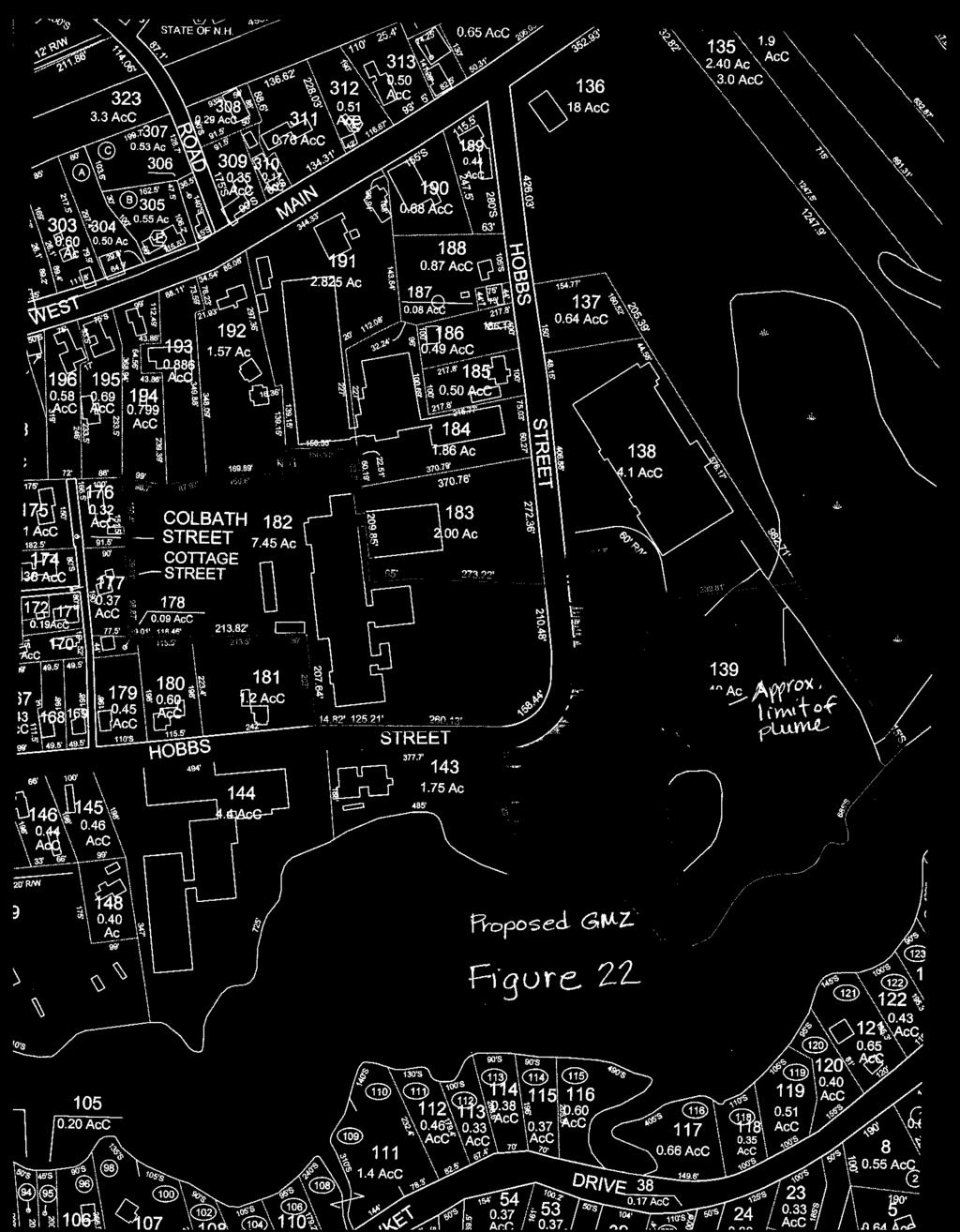
8 Attachment A: Figures from the Weston report Draft Final Post-Source Removal Data Evaluation Report (4/21/08)
9
10
11
12
13
14
15
16
17
18
19
20
21
22
23
24
25
26
27
28
29
30
31 Attachment B: Vertical Profile Figures from Appendix C of the Weston report Draft Final Post- Source Removal Data Evaluation Report (4/21/08)
32
33
34
35
36
37
38
39
40
41 Attachment C: Vertical Profile Figures from Appendix D of the Weston report Draft Final Post- Source Removal Data Evaluation Report (4/21/08)
42
43
44 Attachment D: Figures by GeoTrans of Concentration Versus Time for Selected Monitoring Wells
45 1,1,1-TCA and 1,1-DCE Concentration Trends at EW-13/13B Source Area excavation and P&T system modified Fall Concentration (ug/l) Source Area P&T discontinued December ,1-DCE 1,1,1-TCA Jan-98 Jan-00 Jan-02 Jan-04 Jan-06 Jan-08 Date
46 1,1,1-TCA and 1,1-DCE Concentration Trends at MWS P&T begins Fall 1993 Source Area excavation and P&T system modified Fall 2003 Source Area P&T discontinued December Concentration (ug/l) ,1-DCE 1,1,1-TCA 10 1 Jan-92 Jan-94 Jan-96 Jan-98 Jan-00 Jan-02 Jan-04 Jan-06 Jan-08 Date
47 1,1,1-TCA and 1,1-DCE Concentration Trends at MW-7/MW-3008 MW-3008 since April P&T begins Fall 1993 Source Area excavation and P&T system modified Fall Source Area P&T discontinued December 2005 Concentration (ug/l) ,1-DCE 1,1,1-TCA TCE 10 1 Jan-82 Jan-84 Jan-86 Jan-88 Jan-90 Jan-92 Jan-94 Jan-96 Jan-98 Jan-00 Jan-02 Jan-04 Jan-06 Jan-08 Date
48 1,1,1-TCA and 1,1-DCE Concentration Trends at MW P&T discontinued in December Concentration (ug/l) ,1-DCE 1,1,1-TCA Jan-05 Jan-06 Jan-07 Jan-08 Jan-09 Date
49 1,1,1-TCA and 1,1-DCE Concentration Trends at MW P&T Along Hobbs Street begins in Fall 1993 Source Area excavation and P&T system modified Fall 1000 P&T Along Hobbs Street discontinued in February 2004 Concentration (ug/l) 100 1,1-DCE 1,1,1-TCA TCE 10 1 Jan-91 Jan-93 Jan-95 Jan-97 Jan-99 Jan-01 Jan-03 Jan-05 Jan-07 Date
50 1,1,1-TCA and 1,1-DCE Concentration Trends at MW Concentration (ug/l) P&T discontinued in December ,1-DCE 1,1,1-TCA Jan-05 Jan-06 Jan-07 Jan-08 Jan-09 Date
51 1,1,1-TCA and 1,1-DCE Concentration Trends at PZ P&T discontinued in December 2005 Concentration (ug/l) ,1-DCE 1,1,1-TCA 50 0 Jan-05 Jan-06 Jan-07 Jan-08 Jan-09 Date
52 1,1,1-TCA and 1,1-DCE Concentration Trends at MW Concentration (ug/l) 30 P&T discontinued in December ,1-DCE 1,1,1-TCA Jan-05 Jan-06 Jan-07 Jan-08 Jan-09 Date