FORT ORD REUSE PLAN. Volume 4: Final Environmental Impact Report F O R T O R D R E U S E A U T H O R I T Y. SCH No Certified June 13, 1997
|
|
|
- Bryce Hall
- 5 years ago
- Views:
Transcription


1 F O R T O R D R E U S E A U T H O R I T Y FORT ORD REUSE PLAN Volume 4: Final Environmental Impact Report SCH No Certified June 13, 1997 EMC Planning Group Inc. and EDAW, Inc.
2 FORT ORD REUSE PLAN Environmental Impact Report SCH No Certified: June 13, 1997 Prepared For: Fort Ord Reuse Authority Prepared By: EMC Planning Group Inc. EDAW, Inc. Republished: November 2001 The Final Program Environmental Impact Report (EIR) is comprised of the comments and response to comments on the Fort Ord Reuse Plan Program EIR and the modifications to the text of the EIR. The modifications to the text of the EIR certified by the Board on June 13, 1997 have been incorporated into the Draft EIR and are presented herein.
3 TABLE OF CONTENTS 1.0 Introduction Background to the Project Background and Purpose of the EIR Intended Uses of the EIR Focus of the EIR Environmental Review Process Effects Found not to be Significant Organization of the Document Index to Other Environmental Documents Summary Proposed Project Summary of Setting, Impacts and Mitigation Summary of Other CEQA Considerations Summary of Alternative Analysis Summary Table Project Description Project Objectives Land Use Concept Local General Plan Modifications to Incorporate the Former Fort Ord Properties Redevelopment Planning for Former Fort Ord Properties Potential Changes in City, County and Special District Boundaries Approvals and Permits Required by Local Governments and Regulatory Agencies to Implement the Proposed Project Environmental Setting, Impacts, and Mitigation Land Use Socioeconomics Geology and Soils Public Services, Utilities and Water Supply Hydrology and Water Quality Public Health and Safety Traffic and Circulation Climate and Air Quality Noise Biological Resources Visual Resources Cultural Resources UC MBEST 4-199
4 5.0 Other CEQA Considerations Cumulative Impacts Growth-Inducing Impacts Significant irreversible Environmental Impacts Unavoidable Significant Impacts Alternatives Alternative 6R Alternative Alternative No Project Alternative Report Preparation List of Preparers Persons and Organizations Consulted Bibliography List of Acronyms 7-4 Appendices (Note: Available in hard copy at the Fort Ord Reuse Authority) Appendix A: Notice of Preparation Appendix B: Traffic Background Information Appendix C: Caline 4 Modeling Worksheets
5 LIST OF FIGURES Page Regional Context Map Proposed Project Land Use Concept Revised Land Use Areas Sphere of Influence and Annexation Requests Existing Development Pattern at Fort Ord Generalized Land Use Setting Major Soil Series and Types at Fort Ord Water and Coastal Erosion Potential at Fort Ord Soils with Excavation Caving and Piping Potential at Fort Ord Soils with Low Strength at Fort Ord Soils with High Shrink Swell Potential at Fort Ord Slope Map at Fort Ord Groundwater Containment Plumes Hazardous and Toxic Waste Sites (June 1995) Seismic Hazards Expected Locations of Unexploded Ordnance at Fort Ord Proposed 2015 Transportation Network Buildout Transportation Network Roadway Design Standards Proposed Bicycle Network CNEL Noise Contours for Monterey Peninsula Airport Construction Equipment Noise Ranges Forecast Year 2010 CNEL 65dB Noise Contour for Monterey Peninsula Airport Noise Contours for Marina Airport Biological Communities at Fort Ord Existing Views of East Garrison and Silas B. Hayes Hospital Existing Views of Coastal Dunes and Land East of SR Existing View of Main Entrance Archaeological Resources Sensitivity UC MBEST Land Use UC MBEST Parcelization/Land Use Strategy UC MBEST Center of Business Development Plan UC MBEST Landscape Concept Alternative 6R Land Use Alternative 7 Land Use Alternative 8 Land Use No Project Alternative Land Conveyances 6-23
6 LIST OF TABLES Page Index Table to Other Environmental Documents General Characteristics of the Proposed Project and Project Alternatives Comparison of Key distinguishing Impacts of the Proposed Project and Project Alternatives Summary Table of Proposed Project Impacts and Mitigation Monitoring Plan Revised Land Use Areas Historical and Projected Population of Monterey County and Cities within Monterey County Jobs to Housing Units for Monterey County Distribution of Employment Among Industrial Sectors Estimated Public Services and Utilities Requirements Hazardous and Toxic Waste Sites within Fort Ord LOS Grades by Facility Type Regional Off-Site Roadway Facilities LOS Summary Transportation Infrastructure Improvement Summary On-Site Facilities LOS Summary Roadway Design Standards Federal and State Ambient Air Quality Standards Attainment Status of the North Central Coast Air Basin Thresholds of Significance Criteria for Pollutants of Concern Operational Impacts Weighted Sound Levels and Human Response Monterey County s Land Use Compatibility Criteria for Exterior Community Noise City of Marina Maximum Allowable Ambient Noise Exposure Summary of Traffic Noise Near a Construction Site Distance Attenuation for Noise Near a Construction Site Noise Level Performance Standards for Non-Transportation Noise Sources Summary of Noise Modeling for the Draft Fort Ord Reuse Plan in Resources Considered in the HMP HMP Resources Resources Not Considered in the HMP Non-HMP Resources Summary Table of Proposed Project Impacts and Mitigation Monitoring Plan for UCMBEST Reasonably Foreseeable Future Projects in the Fort Ord Vicinity Comparison of Baseline Conditions, AMBAG Projections, 2015 Projections, and Ultimate Buildout Projections 5-12
7 1.0 Introduction Introduction This Draft Environmental Impact Report (Draft EIR) has been prepared by the Fort Ord Reuse Authority (FORA) as the Lead Agency in accordance with the California Environmental Quality Act (CEQA) and implementing guidelines. The proposed project is the adoption of the Draft Fort Ord Reuse Plan (Reuse Plan) for the former military base known as Fort Ord. As established by Senate Bill (SB) 899, FORA is a governing body, formed to accomplish the transfer of former Fort Ord property from the Department of the Army (Army) to the local communities. The Fort Ord Reuse Authority Act (Title 7.85, Section 67651(a)(b)(c)(d) of the Government Code) requires FORA to accomplish the following: a) To facilitate the transfer and reuse of Fort Ord with all practical speed; b) To minimize the disruption caused by the base s closure on the civilian economy and the people of the Monterey Bay area; c) To provide for the reuse and development of the base area in ways that enhance the economy and quality of life of the Monterey Bay community; and d) To maintain and protect the unique environmental resources of the area. The proposed project is the intended vehicle for achieving these goals. Section 67652(a) of the Government Code identifies the basis for establishing FORA as follows: The policy set forth in Section is most likely to be achieved if an effective governmental structure exists to plan for, finance, and carry out the transfer and reuse of the base in a cooperative, coordinated, balanced, and decisive manner. FORA is governed by a 13-member board consisting of representatives from the following jurisdictions: City of Carmel City of Del Rey Oaks City of Marina City of Sand City City of Monterey City of Pacific Grove City of Salinas City of Seaside County of Monterey Introduction Certified: June 13,
8 1.1 Background to the Project The former Fort Ord Base was downsized and realigned in 1991 pursuant to the Defense Base Closure and Realignment Act of 1990, commonly referred to as BRAC. Before former Fort Ord property can be transferred from military to civilian use, a reuse plan and an environmental review document on the reuse plan must be developed. This Draft EIR has been prepared to evaluate potential impacts to the environment under CEQA that may result from implementing the proposed Draft Fort Ord Reuse Plan, following disposal of former Fort Ord lands by the Department of the Army (Army). A FORA Interim Reuse Plan was presented and analyzed in the Army s Final Environmental Impact Statement (FEIS) SEIS and approved by the FORA Board on December 12, The basis of the Interim Reuse Plan was driven in large measure by the desires and needs of the land use agencies involved. Based on early assessments of the Interim Reuse Plan and extensive outreach to the community, a series of plan refinements were developed and incorporated that addressed both the shortcomings in the original plan and the substantial number of refinements initiated by each of the land use agencies. The result is a revised plan, referred to as the Draft Fort Ord Reuse Plan. The Draft Fort Ord Reuse Plan represents an ultimate buildout scenario for the reuse of the former Fort Ord over the next 40 to 60 years. The level of development proposed under the proposed project is consistent with the level of projected regional growth (as predicted by AMBAG until the year 2015). Some of the environmental impact analyses (e.g., projected traffic impacts) in Chapter 4.0 of this Draft EIR are based on the year 2015, in cases where specific requirements projected for a year buildout could not be realistically determined. A description of the 2015 development scenario is provided in the Draft Fort Ord Reuse Plan. Table in Chapter 5.0 of this Draft EIR also represents 2015 development scenario projections for employment, population, and housing. 1.2 Background and Purpose of the EIR Since the realignment of the former Fort Ord, the Army has prepared the following documents relating to the disposal and reuse of the military base: the Fort Ord Disposal and Reuse Final Environmental Impact Statement (June, 1993) and the Fort Ord Disposal and Reuse Draft Supplemental Environmental Impact Statement (December, 1995), herein referred to as the Army s FEIS and DSEIS. Senate Bill 1180 (as amended February 1995 and contained in CEQA Sections of the California Public Resources Code and the State CEQA Guidelines Section 15221) allows FORA to rely in part on the Army s previous analyses in the FEIS and DSEIS for environmental review of the proposed project. SB 1180 states that the Lead Agency may utilize an environmental impact statement prepared pursuant to federal law as the environmental impact report for a federal military base reuse plan, as defined by conditions described in SB 1180 Section (c). Section requires that the draft environmental impact report shall consist of all or part of the environmental impact statement and any additional information that is necessary to prepare a draft environmental impact report in compliance with this division. Therefore, in 1996 FORA determined it would prepare a Draft EIR with two major objectives: 1) To supply any missing elements from the NEPA documents required in order to comply with CEQA in adopting the Draft Fort Ord Reuse Plan; and 2) To evaluate revisions in the Reuse Plan made since December 12, Introduction 1-2 Certified: June 13, 1997
9 This program-level Draft EIR thus incorporates by reference pertinent background information and analysis from the previous NEPA documents, which is relevant to the identification and evaluation of base-wide environmental impacts addressed in this Draft EIR. This Draft EIR, as certified on June , is therefore a supplemental document to the FEIS and DSEIS prepared by the Army Indexing the Army s FEIS, DSEIS, and Other Documents An Index has been provided in Section 1.9 in the form of a table (Table 1.9-1), in order to simplify for the reader access to relevant information from the Army s previous documents. The Draft EIR summarizes key information from the FEIS and DSEIS where appropriate. Readers interested in further details of a particular resource or analysis will need to refer directly to the Army s FEIS and DSEIS. Since so much environmental documentation on the reuse of former Fort Ord is already available to the public, this Draft EIR seeks not to duplicate previous information, nor to provide additional extraneous detail, but to focus on the critical modifications to previous plans in a concise manner Baseline Determination As with the Army s FEIS and DSEIS, this Draft EIR determines whether the proposed project may have a significant impact on the environment based on physical conditions that were present at the time the decision became final to close Fort Ord as a military base (September, 1991). This complies with Section of the Public Resources Code and utilizes the extensive research already conducted for the Army s NEPA documents, which use the same baseline year. Section (b)(1) of the Public Resources Code states: When preparing and certifying an environmental impact report for a reuse plan, including when utilizing an environmental impact statement...the determination of whether the reuse plan may have a significant effect on the environment may be made in the context of the physical conditions which were present at the time that the federal decision became final for the closure or realignment of the base or reservation. 1.3 Intended Uses of the EIR This program-level EIR is intended to be used as the CEQA compliance document for all public and private actions taken pursuant to, or in furtherance of, a reuse plan [which] shall be deemed a single project (Public Resources Code, Section 21166). Additional, future CEQA analysis beyond this Draft EIR shall be conducted, however, if any of the events specified in Public Resources Code Section should occur, as follows: When an environmental impact report has been prepared for a project pursuant to this division, no subsequent or supplemental environmental impact report shall be required by the lead agency or by any responsible agency, unless one or more of the following events occurs: a) Substantial changes are proposed in the project, which will require major revisions of the environmental impact report; b) Substantial changes occur with respect to the circumstances under which the project is being undertaken which will require major revisions in the environmental impact report; or Introduction Certified: June 13,
10 c) New information, which was not known and could not have been know at the time the environmental impact report was certified as complete, becomes available. CEQA environmental review conducted for future individual projects that implement the Final Fort Ord Reuse Plan will be tiered to this EIR to the extent this program-level analysis remains adequate for such purposes. Section 15152(b) of the State CEQA Guidelines establishes: Where an EIR has been prepared for a program, plan, policy, or ordinance consistent with the requirements of this section, any Lead Agency for a later project pursuant to or consistent with the program, plan, policy, or ordinance should limit the EIR on the project to effects which: 1) Were not examined as significant effects on the environment in the prior EIR; or 2) Are susceptible to substantial reduction or avoidance by the choice of specific revisions in the project, by the imposition of conditions, or other means. Additional CEQA analysis may also be required at the specific project level to give decision makers more information about site-specific issues which are not addressed in this program-level EIR. Agencies that are expected to utilize this Draft EIR in project approvals include the following: Local Agencies County of Monterey City of Marina City of Seaside City of Del Rey Oaks Monterey County Local Agency Formation Commission (LAFCO) State Agencies Fort Ord Reuse Authority (FORA) California Coastal Commission California State Parks Department California State University Monterey Bay (CSUMB) University of California Federal Agencies United States Bureau of Land Management (BLM) United States Army (Army) Introduction 1-4 Certified: June 13, 1997
11 It is understood that certain project-specific environmental documents are in preparation for facilities such as UC MBEST and CSUMB. This document is intended to provide guidance for such project-specific documents and also adequate CEQA review of cumulative and base-wide issues, which may not need to be addressed in subsequent tiered documents. In response to comments received on the Notice of Preparation (NOP), this Draft EIR includes a listing of policies, programs, and CEQA-specific mitigations for which key land use agencies would be responsible. 1.4 Focus of the EIR The Draft EIR focuses on the additional CEQA analysis that is needed to supplement existing analyses in the Army s FEIS and DSEIS. The new information included in this document is highlighted below. [The Army s FEIS and DSEIS should be consulted for all other impact analyses, including impacts associated with the Army s disposal of the former Fort Ord.] CEQA considerations not present in the Army s FEIS and DSEIS The FEIS and DSEIS were reviewed for coverage of CEQA issues not required under NEPA, including: Areas of known controversy of the proposed project; Effects of the proposed project found not to be significant; Impacts to resources of local or statewide concern; Reasonable mitigation measures; Definition of significance criteria in the impact analyses and conclusions regarding the level of significance of each impact; Growth inducing impacts of the proposed project; Significant irreversible environmental changes resulting from the proposed project; and Unavoidable significant impacts of the proposed project. The above issues are addressed in this document Changes in the Proposed Project The Draft EIR also focuses on the proposed project as a modification of FORA s Interim Reuse Plan of December 12, 1994 (Alternative 7), which is analyzed in the Army s DSEIS. The proposed project includes a land use concept as well as several implementation plans and programs (refer to Chapter 3.0 for a more detailed description). The following project components are addressed in this document: The new Draft Fort Ord Reuse Plan, which contains revised land use areas (refer to Figure 3.2-2) that have been modified from the FORA Interim Reuse Plan of December 12, 1994, included the following: Introduction Certified: June 13,
12 Conservation plan; Recreation plan; Transportation plan Capital improvement program; Local general plan modifications to incorporate former Fort Ord properties; Redevelopment planning for former Fort Ord properties; and Potential changes in city, county and special district boundaries within former Fort Ord. The revised land use areas contained in the proposed project consist of additional golf, hotel, equestrian, grade school, community park, and convenience retail opportunities. Additional dwelling units and mixed-use areas are proposed, as well as a slight reconfiguration of the Presidio of Monterey (POM) annex (Now known as Ord Military Community ), and a smaller and less-costly circulation infrastructure. Accompanying plans and programs are included as part of the proposed project in order to implement the land use concept. The Draft EIR has been prepared concurrently with the Draft Fort Ord Reuse Plan (released May, 1996), so as to maximize opportunities to build necessary environmental mitigations into the project planning process. New policies and programs have been developed for each resource element in order to alleviate potential impacts and make the proposed project as self-mitigating as possible. The policies and programs organized as amendments to local general plans serve as a separation of mitigation responsibilities by jurisdiction. FORA must adopt the Reuse Plan, including all policies and programs incorporated in it, in order to approve implementation of the proposed project. This assumes implementation of the policies and programs as a pre-condition of reuse and represents a commitment embodied in the certification of the EIR by FORA Project Alternatives The Draft EIR evaluates a new No Project Alternative which takes into account the land conveyances that have already been completed. This differs from the No Project Alternative used in the DSEIS, which is primarily a caretaker alternative that would occur if the Army was unable to dispose of its property. In this Draft EIR, the No Project Alternative recognizes the current reality of land transfer agreements already in place. [Refer to Section 6.4 in this EIR for a description of lands conveyed under this alternative.] In addition, the Draft EIR considers three alternatives to the proposed project, which were analyzed in detail in the Army s FEIS and DSEIS: Alternatives 6R, 7 and 8. Alternative 6R is evaluated in the FEIS and represents the Revised Anticipated Reuse Plan in that document. Alternative 7 is evaluated as the proposed project in the DSEIS and represents the FORA Interim Reuse Plan of December 12, Alternative 8 is also evaluated in the DSEIS and represents a slight modification of Alternative 7. Introduction 1-6 Certified: June 13, 1997
13 1.5 Environmental Review Process A Notice of Preparation (NOP) was released on January 8, 1996 for a 30-day public review period. The NOP describes the proposed project that is examined in this Draft EIR (a copy is included as Appendix A). Two Public Information and Comment meetings were held on January 22, 1996 and February 12, 1996 to obtain comments on the scope of the EIR. Each issue that was raised during the scoping process has been considered, and those deemed to be within the scope of this EIR are addressed within the document. Following public review of this a Draft EIR, a Final EIR was will be prepared in response to written comments received during the review period. The Final EIR consists of the response to comments under separate cover, as well as the revisions to the text of the Draft EIR included herein. The FORA Board must take the took final action to certify the this EIR, as adequate for decision-making purposes and to approve or deny the proposed Reuse Plan, on June 13, Specific Findings of Fact pursuant to Public Resources Code Section will be were prepared and approved to reflect the final action of the FORA Board. FORA has conducted a continuous coordination program with the local community and regulatory agencies in the process of developing the Draft Fort Ord Reuse Plan through regular working group sessions. Other methods to involve the public in the EIR process have included and will include: publishing public notices of hearings; mailing public announcements; coordinating media coverage, press releases and feature articles; and creating and updating a mailing list to disseminate information. FORA has also been working to provides the public with an this EIR to be which is as simple to understand and as user-friendly as possible, while being consistent with and making reference to previous environmental documents. 1.6 Areas of Known Controversy As required by Section of the CEQA Guidelines, the areas of known controversy known to the lead agency are identified below and addressed in this EIR: Effects on traffic and the need for an adequate road network to serve the proposed level of development; Need for an available and adequate water supply and concern over seawater intrusion into the local groundwater aquifer; Need for and effects of economic development and local growth to replace economic losses due to the military base closure; Regional need for additional and appropriately-located housing, in order to balance the number of local jobs created and to accommodate projected regional population growth; Protection of the visual quality along State Highway 1, the scenic entry to the Monterey Peninsula; Preservation of natural resources and open space; and Effects on the coastal zone. Introduction Certified: June 13,
14 1.7 Effects Found Not to be Significant An Initial Study for the proposed project was not required (pursuant to State CEQA Guidelines Section 15063(a) and Public Resources Code Section ), since FORA determined that an EIR would be necessary based on FORA s decision to rely on the Army s FEIS and DSEIS in identifying significant issues. The NOP identified the following areas of potential impact: Land Use; Socioeconomics; Geology and Soils; Public Services, Utilities and Water Supply; Hydrology and Water Quality; Public Health and Safety; Traffic and Circulation; Climate and Air Quality; Noise; Biological Resources; Visual Resources; and Cultural Resources. The potential for the proposed project to result in significant adverse effects to these environmental resources is analyzed in Chapter 4.0. Effects on energy resources are discussed in this Draft EIR in terms of gas and electrical requirements under Public Services and Utilities, and as a significant irreversible impact (refer to Section 5.3). Potential effects of the proposed project on mineral resources were found not to be significant, because former Fort Ord lands do not contain significant mineral resources which would potentially be used for extraction, and proposed reuse activities are not expected to substantially alter landforms containing mineral resources. Effects on mineral resources are therefore not analyzed further in this Draft EIR. 1.8 Organization of the Document This document is organized into the following sections: Chapter Introduction The Introduction provides a context for the EIR and describes the EIR background and scope, the environmental review process leading to approval of the EIR, as well as some assumptions critical to the environmental analysis. Introduction 1-8 Certified: June 13, 1997
15 1.8.2 Chapter Summary This chapter summarizes the environmental impacts that would result from the proposed project and mitigation measures identified to reduce or eliminate these impacts, other CEQA considerations including cumulative impacts, and alternatives to the project and their associated impacts Chapter Project Description The Project Description describes the proposed project, including: its objectives; the policies and programs associated with the project; modifications to local general plans; redevelopment planning for former Fort Ord properties; and potential changes in city, county, and special district boundaries Chapter Chapter 4.0 briefly characterizes baseline conditions for former Fort Ord land (referencing the Army s FEIS and DSEIS), discusses the environmental impacts associated with the proposed project, identifies levels of significance, and identifies mitigation measures to reduce or eliminate the impacts Chapter Other CEQA Considerations Other considerations required by CEQA are analyzed in this section, including cumulative impacts of the project, growth-inducing impacts, significant irreversible environmental changes, and unavoidable significant impacts Chapter Alternatives This chapter discusses the alternatives to the proposed project and the impacts associated with each alternative. It provides a comparison of the impacts of the alternatives with those of the proposed project Chapter Report Preparation Report Preparation lists the document preparers, persons and organizations consulted, bibliography, and acronyms used in the Draft EIR Appendices The Appendices include supporting documentation for the environmental analyses. 1.9 Index to Other Environmental Documents Table indexes relevant resource sections of the Army NEPA documents and other key documents, and indicates where these resource sections are used in this Draft EIR. Page numbers refer to the first page of the referenced sections. Where necessary, the Draft EIR repeats or condenses key sections from the referenced documents. In general, the environmental setting descriptions presented in this Draft EIR essentially summarize the environmental setting (in 1991) Introduction Certified: June 13,
16 described in the FEIS. Additional information on the environmental setting provided in the Army s DSEIS is also incorporated where necessary. The Impacts and Mitigations and Cumulative Impacts sections of this Draft EIR differ in format and some content from similar sections in the other relevant environmental documents. However, the impact discussions contained in this Draft EIR reference the FEIS and DSEIS and incorporate applicable information wherever appropriate. The primary difference in the impact analyses contained in this Draft EIR is that new information pertaining to the proposed project and CEQA criteria are included. Table Index Table to Other Environmental Documents Issue Areas 1. Land Use Environmental Setting Impacts and Mitigations Cumulative Impacts Fort Ord Reuse Plan Draft EIR (March, 1996) p4-3 p4-7 p5-2 Army s Draft DSEIS (December, 1995) p4-1 p5-12; 5-87 p5-48; 5-92 Army s Final FEISvol. I (June, 1993) p4-3 p6-3 p6-6 Other Documents (see Key) 2. Socioeconomics Environmental Setting Impacts and Mitigations Cumulative Impacts 3. Geology and Soils Environmental Setting Impacts and Mitigations Cumulative Impacts 4. Public Services, Utilities and Water Supply Environmental Setting Impacts and Mitigations Cumulative Impacts 5. Hydrology and Water Quality Environmental Setting Impacts and Mitigations Cumulative Impacts 6. Public Health and Safety Environmental Setting Impacts and Mitigations Cumulative Impacts 7. Traffic and Circulation Environmental Setting Impacts and Mitigations Cumulative Impacts 8. Climate and Air Quality Environmental Setting Impacts and Mitigations Cumulative Impacts p4-20 p4-24 p5-3 p4-27 p4-29 p5-3 p4-36 p4-39 p5-4 p4-45 p4-47 p5-5 p4-53 p4-56 p5-6 p4-68 p4-76 p5-6 p4-90 p4-94 p5-6 p4-3 p5-12; 5-87 p5-49; 5-87 p4-8 p5-19 p5-52 p4-8 p5-20 p5-53 p4-8 p5-22; 5-87 p5-55; 5-93 p4-11 p5-23 p5-57 p4-11 p5-6; 5-88 p5-58; 5-93 p4-12 p5-26; 5-88 p5-61 p4-7 p6-7 p6-14 p4-31 p6-27 p6-31 p4-45 p6-32 p6-37 p4-53 p6-52 p6-56 p4-61 p6-62 p6-62 p4-65 p6-71 p6-74 p4-66 p6-76 p6-76 Soils (entire report); Other (p9-13 and 9-20) OPABS (p6-7 and p9-25) Introduction 1-10 Certified: June 13, 1997
17 9. Noise Environmental Setting Impacts and Mitigations Cumulative Impacts 10. Biological Resources Environmental Setting Impacts and Mitigations Cumulative Impacts 11. Visual Resources Environmental Setting Impacts and Mitigations Cumulative Impacts 12. Cultural Resources Environmental Setting Impacts and Mitigations Cumulative Impacts p-98 p-104 p5-8 p4-113 p4-124 p5-8 p4-143 p4-145 p5-9 p4-150 p4-151 p5-10 p4-13 p5-26 p5-65 p4-23 p5-32; 5-88 p5-66; 5-93 p4-33 p5-44 p5-85 p4-33 p5-45 p5-85 p4-72 p6-77 p6-95 p4-88 p6-106 p6-130 p4-120 p6-132 p6-134 p4-124 p6-135 p6-136 OPABS (Section 3 and p9-17) Key: FORP 4 =Draft Fort Ord Reuse Plan, Chapter 4.0 Reuse Plan Elements, sections indicated (May, 1996). FORP App = Draft Fort Ord Reuse Plan, Appendix: The Business and Operations Plan, sections indicated (May, 1996) Soils = Soils Baseline Study of Fort Ord, California (April, 1992). OPABS = Other Physical Attributes Baseline Study of Fort Ord, California (April, 1992). Introduction Certified: June 13,
18 This page intentionally left blank. Introduction 1-12 Certified: June 13, 1997
19 2.0 Summary Introduction This Draft Environmental Impact Report EIR has been prepared by the Fort Ord Reuse Authority (FORA) as the Lead Agency in accordance with the California Environmental Quality Act (CEQA) and implementing guidelines. The proposed project is the adoption of the Draft Fort Ord Reuse Plan (Reuse Plan) for the former military base known as Fort Ord. The Fort Ord Reuse Authority Act (Title 7.85, Section (a)(b)(c)(d) of the Government Code) requires FORA to accomplish the following: To Facilitate the transfer and reuse of Fort Ord with all practical speed; To minimize the disruption caused by the base s closure on the civilian economy and the people of the Monterey Bay area; To provide for the reuse and development of the base area in ways that enhance the economy and quality of life of the Monterey Bay community; and To maintain and protect the unique environmental resources of the area. The former Fort Ord base was downsized and realigned in 1991 pursuant to the Defense Base Realignment and Closure Act of 1990, since commonly referred to as BRAC. Before reuse of former Fort Ord property can be effectively transferred from military to civilian use ownership, a reuse plan and an environmental review document on the reuse plan must be developed. This Draft EIR has been prepared to evaluate potential impacts to the environment under CEQA that may result from implementing the proposed Draft Fort Ord Reuse Plan, following disposal of former Fort Ord lands by the Department of the Army (Army). Since the realignment of the former Fort Ord, the Army has prepared the following documents relating to the disposal and reuse of the military base: the Fort Ord Disposal and Reuse Final Environmental Impact Statement (June, 1993) and the Fort Ord Disposal and Reuse Draft Supplemental Environmental Impact Statement (December, 1995), herein referred to as the Army s FEIS and DSEIS. Senate Bill 1180 allows FORA to rely in part on the Army s previous analyses in the FEIS and DSEIS for environmental review of the proposed project. This Draft EIR has two major objectives: 1) To supply any missing elements from the NEPA documents required in order to comply with CEQA in adopting the Draft Fort Ord Reuse Plan; and 2) To evaluate revisions in the Reuse Plan made since December 12, This program-level Draft EIR thus incorporates by reference pertinent background information and analysis from the Army s FEIS and DSEIS, and essentially serves as a supplemental document to these previous NEPA documents. As with the Army s FEIS and SDEIS, this Draft EIR determines whether the proposed project may have a significant impact on the environment based on physical conditions that were present at the time the decision became final to close Fort Ord as a military base (September, 1991). Summary Certified: June 13,
20 CEQA environmental review conducted for future individual projects that implement the Final Fort Ord Reuse Plan will be tiered to this EIR to the extent this program-level analysis remains adequate for such purposes. Additional CEQA analysis may also be required at the specific project level to give decision makers more information about site-specific issues which are not addressed in this program-level EIR. 2.1 Proposed Project The proposed project represents an ultimate buildout scenario for the former Fort Ord over the next years. This EIR focuses on the development capacity through year Under the proposed project, more than 27,000 acres of the former Fort Ord would be transferred from the Department of the Army (Army) to a number of government agencies and local organizations which would have land use control within the former Fort Ord. The transfer and redevelopment of such a large area would necessitate substantial restructuring of local jurisdictional boundaries, the incorporation of new local policies and programs to guide development, implementation strategies including capital improvements, and future land management plans. The proposed project addresses all these factors and therefore serves as a long-term, regionally focused, and comprehensive reuse plan, functioning at the general plan level. The Draft Fort Ord Reuse Plan incorporates substantial development of educational, residential, office, light industrial, commercial, and recreational land uses with the majority of the former Fort Ord managed for open space and habitat protection under the Fort Ord Installation Wide Multi- Species Habitat Management Plan recently agreed to by the involved agencies. Implementation of the proposed project would result in the development of approximately 22,232 dwelling units (including dormitory housing), 45,457 jobs, and a buildout population of approximately 51,773 with an additional 20,000 CSUMB residential students. The adopted project is significantly reduced in size and accomplishes about 50% of these projections by [For a more detailed description, refer to Chapter 3.0 of this Draft EIR.] Accompanying policies and programs are included as part of the proposed project in order to implement the land use concept. The Draft EIR has been was prepared concurrently with the Draft Fort Ord Reuse Plan (released May, 1996), so as to maximize opportunities to build necessary environmental mitigations into the project planning process. New policies and programs have been developed for each resource element in order to alleviate potential impacts and make the proposed project as self-mitigating and possible. The policies and programs organized as amendments to local general plans serve as a separation of mitigation responsibilities by jurisdiction. FORA must adopt the Reuse Plan, including all policies and programs incorporated in it, in order to approve implementation of the proposed project. Significant Differences Between the Proposed Project and Alternatives Presented in the Army s FEIS and DSEIS The Army s DSEIS analyzes Alternative 7 (FORA s Interim Reuse Plan) and a minor modification of this alternative labeled Alternative 8. The Army s FEIS analyzes Alternatives 1 through 6R and their sub-alternatives. The proposed project in this Draft EIR is relatively similar to Alternatives 7 and 8, but is significantly different from Alternatives 1 through 6R. The principal differences Summary 2-2 Certified: June 13, 1997
21 CEQA environmental review conducted for future individual projects that implement the Final Fort Ord Reuse Plan will be tiered to this EIR to the extent this program-level analysis remains adequate for such purposes. Additional CEQA analysis may also be required at the specific project level to give decision makers more information about site-specific issues which are not addressed in this program-level EIR. 2.1 Proposed Project The proposed project represents an ultimate buildout scenario for the former Fort Ord over the next years. This EIR focuses on the development capacity through year Under the proposed project, more than 27,000 acres of the former Fort Ord would be transferred from the Department of the Army (Army) to a number of government agencies and local organizations which would have land use control within the former Fort Ord. The transfer and redevelopment of such a large area would necessitate substantial restructuring of local jurisdictional boundaries, the incorporation of new local policies and programs to guide development, implementation strategies including capital improvements, and future land management plans. The proposed project addresses all these factors and therefore serves as a long-term, regionally focused, and comprehensive reuse plan, functioning at the general plan level. The Draft Fort Ord Reuse Plan incorporates substantial development of educational, residential, office, light industrial, commercial, and recreational land uses with the majority of the former Fort Ord managed for open space and habitat protection under the Fort Ord Installation Wide Multi- Species Habitat Management Plan recently agreed to by the involved agencies. Implementation of the proposed project would result in the development of approximately 22,232 dwelling units (including dormitory housing), 45,457 jobs, and a buildout population of approximately 51,773 with an additional 20,000 CSUMB residential students. The adopted project is significantly reduced in size and accomplishes about 50% of these projections by [For a more detailed description, refer to Chapter 3.0 of this Draft EIR.] Accompanying policies and programs are included as part of the proposed project in order to implement the land use concept. The Draft EIR has been was prepared concurrently with the Draft Fort Ord Reuse Plan (released May, 1996), so as to maximize opportunities to build necessary environmental mitigations into the project planning process. New policies and programs have been developed for each resource element in order to alleviate potential impacts and make the proposed project as self-mitigating and possible. The policies and programs organized as amendments to local general plans serve as a separation of mitigation responsibilities by jurisdiction. FORA must adopt the Reuse Plan, including all policies and programs incorporated in it, in order to approve implementation of the proposed project. Significant Differences Between the Proposed Project and Alternatives Presented in the Army s FEIS and DSEIS The Army s DSEIS analyzes Alternative 7 (FORA s Interim Reuse Plan) and a minor modification of this alternative labeled Alternative 8. The Army s FEIS analyzes Alternatives 1 through 6R and their sub-alternatives. The proposed project in this Draft EIR is relatively similar to Alternatives 7 and 8, but is significantly different from alternatives 1 through 6R. The principal differences Summary 2-2 Certified: June 13, 1997
22 between the current Draft Fort Ord Reuse Plan and previous Alternatives 7 and 8 have resulted in a proposed project that: limits impacts on limited water supply; is more economically feasible; contains a down-scaled and less-costly circulation infrastructure; satisfies the demand for adequate housing in the local region; includes increased recreational and tourist opportunities; and Integrates land uses better. 2.2 Summary of Setting, Impacts and Mitigation This Summary provides an overview of the analysis contained in Chapter 4.0 Environmental Setting, Impacts on Mitigation. This summary includes discussion of: Beneficial impacts; Less than significant impacts; Significant but mitigable impacts; and Unavoidable significant impacts. The reuse of former Fort Ord under the Draft Fort Ord Reuse Plan would result in a number of beneficial impacts in comparison with 1991 conditions. Beneficial impacts include: Socioeconomic impacts associated with the improved employment base and jobs to housing balance; Visual quality improvements in existing developed or disturbed areas; and Cumulative biological resource protection due to implementation of the Habitat Management plan. The reuse of former Fort Ord under the proposed project would result in less than significant impacts in the following resource areas: Socioeconomics; Geology and Soils; Hydrology and Water Quality; Climate and Air Quality; Biological Resources; and Cultural Resources. Under CEQA, a significant effect on the environment is defined as a substantial, or potentially substantial, adverse change in any physical conditions within the area affected by the proposed project. Significant or potentially significant but mitigable impacts under the proposed project would include: Land use impacts relating to incompatible land uses and development in the coastal zone; Summary Certified: June 13,
23 Public services, utilities, and water supply impacts relating to the need for new systems, services, and supplies; Public health and safety impacts relating to the exposure to hazardous and toxic materials; Visual resources impacts relating to reduced visual quality from increased development within the former Fort Ord and reduced visual quality seen from the Salinas Valley. Significant impacts, which would be unavoidable under the proposed project, include: Proposed project and cumulative-level public health, and safety impacts relating to the increased demand for law enforcement services and the increased demand for fire protection/emergency services; Cumulative public services, utilities, and water supply impacts associated with the need for local water supplies; Proposed project and cumulative-level traffic and circulation impacts relating to the increased demand on the regional transportation system; and Cumulative visual resource impacts associated with landscape change along the SR1 corridor. A more detailed summary of the impact analyses contained in Chapter 4.0 is presented in Table at the end of this chapter. The summary table is arranged in seven columns. The first column registers impacts to the resources of concern that would result from the proposed project. The second column lists the policy and program statements developed in the Draft Fort Ord Reuse Plan (Reuse Plan), which are designed to mitigate potential impacts. These policies and programs represent commitments by FORA and its member agencies that are built in to the project, and in many cases additional mitigation measures are not needed. The level of significance before and after mitigation is also summarized in the table. Mitigation measures are identified for those impacts, which are considered to be significantly or potentially significant, after implementation of the Reuse Plan policies and programs. Generally, program-level mitigation for the impacts includes modifications to the Draft Fort Ord Reuse Plan or the addition of other requirements. The mitigations recommended to address significant impacts identified in this document form the basis of the mitigation monitoring plan Mitigation Monitoring Plan Mitigation measures are identified for those impacts, which are considered to be significant or potentially significant, after implementation of the Reuse Plan policies and programs. In compliance with CEQA Guidelines (Section of the Public Resources Code), a mitigation monitoring and reporting program must be developed as part of the CEQA process prior to project approval. The draft Mitigation Monitoring Plan for the proposed project has been combined with the summary of impacts and mitigation measures into Table (at the end of this chapter). The mitigation schedule and mitigation responsibility are included as columns six and seven of the summary table. Summary 2-4 Certified: June 13, 1997
24 2.3 Summary of Other CEQA Considerations This summary provides an overview of the analyses contained in Chapter 5.0 Other CEQA Considerations. The following discussion summarizes: Cumulative Impacts; Growth inducing impacts; Significant irreversible environmental changes; and Unavoidable significant impacts Cumulative Impacts In conformance with CEQA, a cumulative impact of the proposed project is the change in the environment which results from the incremental impact of the proposed project when added to other closely related past, present and reasonably foreseeable probable future projects (CEQA Guidelines, Section 15355(b)). The cumulative impact analyses in this Draft EIR refer to the combined effects of both the proposed project and AMBAG projections for regional growth, including reasonably foreseeable future projects in Monterey County and local cities as identified in Table These impacts are discussed in Section 5.1 of this Draft EIR and identified in Table Growth Inducing Impacts Under CEQA, a growth inducing impact of the proposed project is one that would foster economic or population growth, or the construction of additional housing, either indirectly or directly, in the surrounding environment. The initial phase of development to the year 2015 would not result in a growth inducing impact. Economic, population, and residential increases occurring until the year 2015, as proposed by the Reuse Plan, would constitute only a recovery to the approximate 1991 levels of activity. Beyond 2015, buildout of the proposed project is intended to absorb a substantial portion of Monterey Bay Peninsula ( Peninsula ) growth that is already predicted by AMBAG to occur. Because the proposed project is designed to capture much of the future growth, it is not expected that the Reuse Plan would substantially foster growth in the surrounding environment without. A component of additional growth is possible since the establishment of an educational/research center on the former Fort Ord has the potential to attract statewide and nationwide populations to the area which would not otherwise occur. However, the overall Reuse Plan is not expected to remove certain obstacles to growth. The regional water supply shortage in particular would not be solved by the proposed project and would remain a limitation on regional growth Significant Irreversible Environmental Changes Implementation of the proposed project is not expected to involve a large commitment of renewable resources, except for the building materials required to develop new structures. The reuse of existing buildings on the former Fort Ord would decrease the need for these materials. The proposed project would contribute to the permanent conversion of nondeveloped land to Summary Certified: June 13,
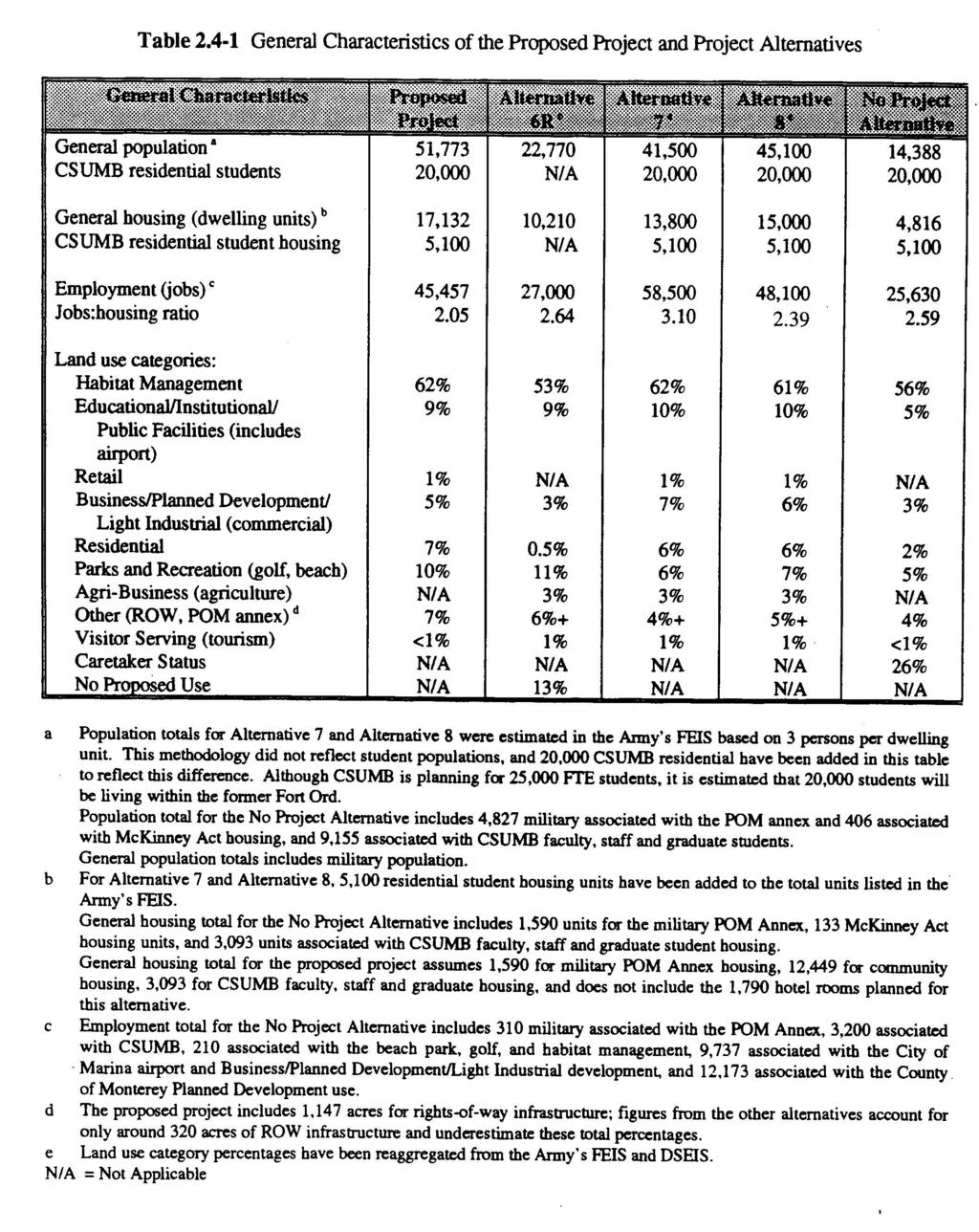
25 residential, business, public facility, educational, and mixed uses on the former Fort Ord. This would commit future generations to developed uses. The proposed project would result in the irretrievable commitment of energy resources for increased electricity and gas demands and in the form of gasoline for construction vehicles and vehicles commuting to the area. The proposed project would also result in the irretrievable commitment of water resources in the form of potable and non-potable water supplies. The proposed project is not expected to pose a high risk of environmental accidents Unavoidable Significant Impacts Under CEQA, a significant and unavoidable impact of the proposed project is one that would cause a substantial adverse effect on the environment and for which no mitigation is available to reduce the impact to a less-than-significant level if the Reuse Plan is approved. These impacts are discussed in Section 5.4 of this Draft EIR and identified in Table Summary of Alternative Analysis The four alternatives to the proposed project considered in this EIR consist of: Alternative 6R Alternative 7 Alternative 8 No Project Alternative (Revised Anticipated Reuse; as described in the Army s FEIS) (FORA Interim Reuse Plan; as described in the Army s DSEIS) (Slight modification of Alternative 7; as described in the Army s DSEIS) (New alternative; caretaker status under the Army except for existing conveyances) Table compares the general characteristics of Alternatives 6R, 7, 8, and No Project with the proposed project. The table provides a summary comparison of the population, housing, employment, and land use contained in Chapter 6.0. The five reuse scenarios propose total housing in the range of 4,816-17,132 dwelling units (not including student housing). Total population ranges from 14,388-51,773 (not including student population) and employment ranges from 25,630-58,500. These numbers represent the general levels of development being considered for the former Fort Ord area. Table summarizes the key distinguishing impacts of the project alternatives, as evaluated in Chapter 6.0, and compares it to the proposed project impacts (after application of mitigation measures) The Environmentally Superior Alternative The reuse scenario under the No Project Alternative would result in the least environmental impacts, and is, therefore, the environmentally superior alternative at a local level. This is based on Summary 2-6 Certified: June 13, 1997
26 the acreage of open space and habitat conservation in relation to development, projected population, and the level of construction for development and infrastructure. Under the No Project Alternative, only 13% of the total former Fort Ord property (or 3,800 acres) would be developed; this would include already existing development and land remaining under the Army. Approximately 56% of the former Fort Ord would be left undeveloped for habitat management (15,648 acres), 5% of the land would have little or no development for parks and recreation (1,320 acres), and an additional 26% (7,200 acres) would be left undeveloped under Army caretaker status. The No Project Alternative would have more adverse impacts than the proposed project in terms of jobs to housing ratios and regional traffic. It would have less impact in many categories, as show in Table However, the No Project Alternative would not meet the project objectives of developing an economic/employment recovery to compensate for base closure and accommodate regional growth. At the cumulative level, substantial regional growth would still be projected, with potentially greater impacts on other land (e.g., farmland or open space) should development occur outside the former Fort Ord. The CEQA Guidelines require that an additional environmentally superior alternative be identified in cases where the No Project Alternative represents the environmentally superior alternative. Alternative 6R has been selected as the second environmentally superior alternative. This selection is based on projected population and the assumption that the 3,700 acres (13% of the former Fort Ord) designated as No Proposed Use would not be developed. Under Alternative 6R, approximately 22.5% (6,100 acres) of total former Fort Ord land would be developed, and 53% (17,195 acres) would be left undeveloped for habitat management and parks and recreation. A comparative discussion with the proposed project is provided in the next section Comparisons with the Proposed Project Table provides a summary comparison of alternatives. Chapter 6.0 should also be consulted for more details of impacts by alternative. Compared with Alternative 6R, the proposed project would have less impact in terms of coastal land use compatibility, jobs to housing ratios, loss of coastal habitat, effects on beach/dune habitat, loss of oak woodland, effects on wetlands, and effects on visual resources. The proposed project would have more adverse impact in terms of potential incompatibility of land uses at East Garrison, increased generation of solid waste, demand for water supply, demand for law enforcement and fire protection services, increased traffic, and increased noise. However, unlike alternative 6R, the proposed project contains a comprehensive set of policies and programs, which reduce the potential impacts to these resources substantially, as described in Chapter 4.0. Alternative 6R would also not fully meet the project objectives. Compared with Alternative 7, the proposed project would have less impact in terms of general incompatibility of adjoining land uses within the former Fort Ord, jobs to housing ratios, hydrology and water quality, traffic noise, loss of coastal strand habitat, loss of dune scrub, effects of beach/dune habitat, loss of oak woodland, and effects on wetlands and visual resources. The proposed project would have more adverse impact in terms of potential incompatibility of land uses Summary Certified: June 13,
27 at East Garrison, increased generation of solid waste, and demand for law enforcement services. However, the project includes a comprehensive set of policies and programs, which reduce the potential impacts considerably, as described in Chapter 4.0. Relative to the proposed project, Alternative 7 would have greater cumulative and regional effect on traffic and associated environmental effects due to the creation of over 10,000 more jobs with a population at the former Fort Ord of approximately 10,000 fewer residents. The anticipated impacts of Alternative 8 would be very similar in general to those described above for Alternative 7 in relation to the proposed project. The principal difference would be that Alternative 8 would produce similar impacts as under the proposed project in terms of jobs to housing ratio and demand for law enforcement services and traffic, although without the benefits of the policies and programs. 2.5 Summary Table Table provides a detailed and comprehensive summary of proposed project impacts and mitigation measures. Summary 2-8 Certified: June 13, 1997
28
29
30
31
32
33
34
35
36
37
38
39
40
41
42
43
44
45
46
47
48
49
50
51
52
53
54 3.0 Project Description Introduction The proposed project being evaluated in this Draft EIR is the land use development plan and related implementation components contained in the Draft Fort Ord Reuse Plan. The Reuse Plan includes a land use concept as well as the following related components: Conservation plan; Recreation plan; Transportation plan; Capital improvement program; Local general plan modifications to incorporate former Fort Ord properties; Redevelopment planning for former Fort Ord properties; and Potential changes in city, county and special district boundaries within the former Fort Ord. The land use concept is the primary focus of the impact analyses contained in this Draft EIR. For the purpose of describing the comprehensive plan, the project components listed above are briefly summarized in this chapter. This chapter also describes the project objectives and the approvals and permits required by local governments and regulatory agencies to implement the proposed project. The Draft Fort Ord Reuse Plan is summarized in this chapter and is herein incorporated by reference. the document and should be read in conjunction with this Draft EIR. Project Site The project site is the former Department of the Army (Army) military facility known as Fort Ord. The former Fort Ord occupies approximately 27,964 acres of land along the Pacific Ocean, 100 miles south of San Francisco, California. The site is located in northern Monterey County and is adjacent to the Cities of Marina, Seaside, Sand City, Del Rey Oaks, and Monterey (refer to Figure 3.2-1). Under the proposed project, approximately 27,000 acres of former Fort Ord would be transferred from the Army to a number of government agencies and local organizations that would have land use control within former Fort Ord. The transfer and redevelopment of such a large area would necessitate substantial restructuring of local jurisdictional boundaries, the incorporation of new local policies and programs to guide development, implementation strategies including capital improvements, and future land management plans. The proposed project addresses all these factors and therefore serves as a long-term, regionally focused, and comprehensive reuse plan. Project Description Certified: June 13,
55 Figure Regional Context Map This figure can be found within the Maps section off the homepage of the FORA CD-ROM Application. Project Description 3-2 Certified: June 13, 1997
56 3.1 Project Objectives With the closure of the former Fort Ord, the local region has lost a substantial portion of its population, jobs, and amount of economic activity previously supplied by the Army. At the same time, however, the local region has gained a well-located and environmentally rich piece of property, which has effectively been unavailable to the community since The Draft Fort Ord Reuse Plan endeavors both to satisfy local community needs, and take advantage of new opportunities by replacing lost jobs and revenue and preserving the natural beauty and biological resources of the property. FORA s vision for the proposed project is a reuse and development strategy focused on the three Es: economic development, the environment, and education. The Fort Ord Reuse Authority Act (Title 7.85, Section 67651(a),(b),(c), and (d) of the Government Code) declares the following goals for the reuse of former Fort Ord to be the policy of the State of California: a) To facilitate the transfer and reuse of Fort Ord with all practical speed; b) To minimize the disruption caused by the base s closure on the civilian economy and the people of the Monterey Bay area; c) To provide for the reuse and development of the base area in ways that enhance the economy and quality of life of the Monterey Bay community; and d) To maintain and protect the unique environmental resources of the area. The Fort Ord Reuse Authority Act indicates that all former Fort Ord property that has been transferred from the federal government must be used in a manner that is consistent with the Reuse Plan, except for property transferred to the California State University or the University of California that is used for education related or research-oriented purposes, and excluding property transferred to the California Department of Parks and Recreation used for its recreational mission. The Draft Fort Ord Reuse Plan represents an ultimate buildout scenario for the former Fort Ord over the next 40 to 60 years. The level of development proposed under the proposed project is consistent with the level of projected regional growth (as predicted by AMBAG until the year 2015). It is the intent of the proposed project to accommodate a substantial portion of this regional growth, and also to share in the funding of regional expenditures such as circulation infrastructure improvements. The proposed project, as considered within the context of the overall Draft Fort Ord Reuse Plan, is also intended to be self-mitigating. Policy and program statements included in Chapter Reuse Plan Elements of the Draft Fort Ord Reuse Plan are designed to mitigate potential adverse effects of the proposed project Basis of the Reuse Plan FORA s Interim Reuse Plan was presented and analyzed in the Army s DSEIS and approved by the FORA Board on December 12, The basis of the Interim Reuse Plan was driven in large Project Description Certified: June 13,
57 measure by the desires and needs of the land use agencies involved. Early assessment of the plan concluded the following: Market Support. The balance of land uses in the plan did not match the market on the Peninsula for these uses. There was a significant oversupply of industrial/business park land uses and an insufficient amount of residential land uses. Circulation Capacity. The extent of new circulation network in the plan appeared to be significantly out of balance with the land served resulting in serious coast considerations. In addition, the roadway network pattern resulted in a significant impact on State Highway 1 by overloading the 12th Street interchange and under-utilizing the capacity of the Main Gate intersection. Infrastructure Costs. The cost estimates prepared during the FORIS Infrastructure Study completed in January 1995 indicated a potentially significant burden on the land that threatened the financial feasibility of the plan. Plan Refinements Based on the early assessments and on extensive outreach to the community, a series of plan refinements were developed. A Community Vision Session was sponsored by FORA to provide a forum to identify issues and concerns. Plan refinements were incorporated that addressed both the shortcomings in the original Interim Reuse Plan, and the substantial number of refinements prompted by the Community Vision Session and initiated by each of the land use agencies. The revised Draft Fort Ord Reuse Plan maintains the fundamental elements of the original community vision through incorporation of the following: Environmental Protection. The Fort Ord Installation Wide Multi-Species Habitat Management Plan (HMP) was respected, incorporated by reference, and only minor refinements of the boundary within the U. S. Bureau of Land Management (BLM) habitat lands were incorporated into the Land Use Concept. Mix of Land Uses. The same mix of land uses is retained. The proportional representation of each land use has been changed to reflect the Peninsula real estate market and a reuse strategy that leveraged the housing market to enhance the attractiveness of the former Fort Ord as a jobs center. Circulation System. Several changes were made to the circulation network to reduce land committed to roadways, reduce the size of the roadway, and take advantage of existing improvements to reduce costs. Development Strategies As a result of the refinement process, the focus shifted to the implementation strategies that could optimize the financial viability of the Reuse Plan. Development strategies were articulated for the market, circulation, infrastructure extension, community-building synergies, and fiscal strategies. Project Description 3-4 Certified: June 13, 1997
58 3.1.2 Significant Differences between the Proposed Project and Alternatives presented in the Army s FEIS and DSEIS The Army s DSEIS analyzed Alternative 7 (FORA s Interim Reuse Plan) and a minor modification of this alternative labeled Alternative 8. The Army s FEIS analyzed Alternatives 1 through 6R and their subalternatives. The proposed project in this Draft EIR is relatively similar to Alternatives 7 and 8, but is significantly different from Alternatives 1 through 6R. The principal differences between the current Draft Fort Ord Reuse Plan and previous Alternatives 7 and 8 have resulted in a proposed project that: is more economically feasible; contains a down-scaled and less-costly circulation infrastructure; satisfies the demand for adequate housing in the local region; includes increased recreational and tourist opportunities; and better integrates land uses. A more detailed description of the differences between the proposed project and Alternatives 7 and 8 is presented in Table Land Use Concept Figure shows the ultimate development land use concept for the proposed project. Implementation of the proposed project would result in the development of approximately 22,232 dwelling units (including 5,100 CSUMB on-campus housing), 45,457 jobs, and a buildout population of approximately 51,773 plus 20,000 CSUMB on-campus students. The appropriate division of total acreage on the former Fort Ord by land use category would be as follows: 62% Habitat Management; 9% Educational/Institutional/Public Facilities (includes airport); 1% Retail; 5% Business Park/Light Industrial/Planned Development; 7% Residential; 10% Parks and Recreation (beach, golf); 0% Agribusiness; 7% Other (rights-of-way 4%; POM annex 3%); and <1% Visitor Serving. Under the proposed project, 62% (or 17,367 acres) of the former Fort Ord would be left undeveloped and would be included as part of a habitat management program. The BLM would manage approximately 15,000 acres and the remainder would be managed by the California Department of Parks and Recreation (CDPR), the University of California Natural Reserve System, Monterey County, and the City of Marina. Under the proposed project, approximately Project Description Certified: June 13,
59 acres would stay under the Army as a military enclave (i.e., POM annex, reserve center). The remaining approximately 29% of former Fort Ord (or 7,919 acres) would be developed according to the urban land uses described above, and 10% of land (or 2,692 acres) would be developed or left undeveloped for parks and recreation. Consistent with the analysis in the Army s DSEIS, the easement for potential future SR 68 improvements in the southern portion of former Fort Ord is treated as an open space and habitat management area (refer to Figure 3.2-1). Caltrans and BLM have an approved MOU which addresses future uses of the Highway 68 Bypass easement and interim management of lands within the corridor Proposed Project Land Uses The proposed project is a modification of FORA s Interim Reuse Plan of December 12, 1994 (Alternative 7). Compared to Alternative 7, the proposed project represents lower land use densities associated with commercial and industrial uses, fewer overall jobs created, and a down-scaled circulation plan. The proposed project also represents an overall increase in dwelling units and mixed-use development, in order to create a more balanced jobs-housing ratio. The proposed project is more economically feasible than Alternatives 7 and 8 and responds to the lack of adequate housing in the local communities, while still providing educational opportunities, economic recovery, environmental protection, and recreational opportunities. The primary land use differences between Alternative 7 and the proposed project are described in Table and shown in Figure 3.2-2, and are represented as either substantially revised or slightly revised areas. Three polygon areas revised under the proposed project differ substantially from reuse alternatives considered in the Army s FEIS and DSEIS; these are polygons 1c, 4 and 1b. Polygon 1c is a light industrial use area in both Alternative 7 and the proposed project, but opportunities for golf and hotel are included under the proposed project. Polygon 4 is modified from low density to medium density residential, with opportunities for a golf course, high school, community park, and convenience retail. Polygon 11b is designated for agri-business use under Alternative 7 and has been changed to business park development with equestrian use opportunities. Several other polygons represent slightly different changes in land use intensity or type, and are associated primarily with residential, mixed-use areas, and recreational uses. A potential site for a desalination plant (polygon 14c) is assumed for purposes of the impact assessment. The reconfiguration of the military enclave is also considered a slight revision from Alternative Conservation Plan A conservation plan is described in the Conservation Element of the Draft Fort Ord Reuse Plan (refer to Chapter Reuse Plan Elements). The Conservation Element conveys goals and policies related to soils and geology, hydrology and water quality, biological resources, and air quality. The Conservation Element, which is state-mandated, requires that the natural resources within the boundaries of former Fort Ord are supervised in perpetuity and that these resources are not diminished. It identifies important natural resources at former Fort Ord, recognizes their irreplaceable value and limited quantities, and provides specific strategies for their preservation. The Conservation Element s contents respond to California environmental laws, including the Clean Water Act and the Clean Air Act. Project Description 3-6 Certified: June 13, 1997
60 would stay under the Army as a military enclave (i.e., POM annex, reserve center). The remaining approximately 29% of former Fort Ord (or 7,919 acres) would be developed according to the urban land uses described above, and 10% of land (or 2,692 acres) would be developed or left undeveloped for parks and recreation. Consistent with the analysis in the Army s DSEIS, the easement for potential future SR 68 improvements in the southern portion of former Fort Ord is treated as an open space and habitat management area (refer to Figure 3.2-1). CalTrans and BLM have an approved MOU which addresses future uses of the Highway 68 Bypass easement and interim management of lands within the corridor Proposed Project Land Uses The proposed project is a modification of FORA s Interim Reuse Plan of December 12, 1994 (Alternative 7). Compared to Alternative 7, the proposed project represents lower land use densities associated with commercial and industrial uses, fewer overall jobs created, and a down-scaled circulation plan. The proposed project also represents an overall increase in dwelling units and mixed-use development, in order to create a more balanced jobs-housing ratio. The proposed project is more economically feasible than Alternatives 7 and 8 and responds to the lack of adequate housing in the local communities, while still providing educational opportunities, economic recovery, environmental protection, and recreational opportunities. The primary land use differences between Alternative 7 and the proposed project are described in Table and shown in Figure 3.2-2, and are represented as either substantially revised or slightly revised areas. Three polygon areas revised under the proposed project differ substantially from reuse alternatives considered in the Army s FEIS and DSEIS; these are polygons 1c, 4 and 1b. Polygon 1c is a light industrial use area in both Alternative 7 and the proposed project, but opportunities for golf and hotel are included under the proposed project. Polygon 4 is modified from low density to medium density residential, with opportunities for a golf course, high school, community park, and convenience retail. Polygon 11b is designated for agri-business use under Alternative 7 and has been changed to business park development with equestrian use opportunities. Several other polygons represent slightly different changes in land use intensity or type, and are associated primarily with residential, mixed-use areas, and recreational uses. A potential site for a desalination plant (polygon 14c) is assumed for purposes of the impact assessment. The reconfiguration of the military enclave is also considered a slight revision from Alternative Conservation Plan A conservation plan is described in the Conservation Element of the Draft Fort Ord Reuse Plan (refer to Chapter Reuse Plan Elements). The Conservation Element conveys goals and policies related to soils and geology, hydrology and water quality, biological resources, and air quality. The Conservation Element, which is state-mandated, requires that the natural resources within the boundaries of former Fort Ord are supervised in perpetuity and that these resources are not diminished. It identifies important natural resources at former Fort Ord, recognizes their irreplaceable value and limited quantities, and provides specific strategies for their preservation. The Conservation Element s contents respond to California environmental laws, including the Clean Water Act and the Clean Air Act. Project Description 3-6 Certified: June 13, 1997
61 Figure Proposed Project Land Use Concept This figure can be found within the Maps section off the homepage of the FORA CD-ROM Application. Project Description Certified: June 13,
62 This page intentionally left blank. Project Description 3-8 Certified: June 13, 1997
63 Figure Revised Land Use Areas This figure can be found within the Maps section off the homepage of the FORA CD-ROM Application. Project Description Certified: June 13,
64 Polygon Number Land Use Under Alternative 7/Alternative 8 Table Revised Land Use Areas Land Use Under the Proposed Project Source of Difference 1a Airport (AIR) BP/LI/O/R&D Land uses are consistent 1b Habitat Preserve (HAB) Habitat Management Slight Boundary Shift 1c Business Park (AIR/BP) BP/LI/O/R&D with Hotel and Golf Course Opportunity Sites Hotel and Golf Course 1d This polygon was eliminated by the Blanco Road right-of-way reserve. 1e Habitat Preserve (HAB) Habitat Management Land uses are consistent 1f High Tech Business Park (TECH) Public Facility/Institutional and BP/LI/O/R&D 2a Retail (RET) Mixed-Use District, Med. Residential and Open Space/Recreation Land uses are consistent Med. Residential 2b Multiple Uses (HR/CBUS) Mixed-Use District Land uses are consistent 2c 2d High Tech Business Park (TECH) Retail (RET) and High Density Residential Mixed-Use District with Convenience Retail Mixed-Use District and Open Space/Recreational 2e Corporation Yard (CORP) Half of Polygon Now Considered Mixed-Use District Difference in predominant uses Difference in predominant uses Portion of polygon considered mixed-use district 2f Bus Transfer Center (BTC) Mixed-Use District Difference in predominant uses 2g Equestrian Center Equestrian Center Expansion of use to the south 3 University Community College (UNIV/CC) School/University Land uses are consistent 4 Low Density Residential (LR) Med. Residential with Residential Infill, Golf Course, and High School opportunities; Open space/recreation; and convenience retail Increase in housing density; potential golf course and high school; park 4a School (SCH) School/University Land uses are consistent 5a Retail (RET) Mixed-Use District with Convenience Retail and High School Opportunity Potential difference in predominant uses and potential high school 5b Business Park (BP) Habitat Management Difference in predominant uses 5c University Research Area (HAB) Habitat Management No Change 6a Reserve Center (RC) Military Enclave No Change 6b University Research Area (HAB) Habitat Management No Change Project Description 3-10 Certified: June 13, 1997
65 7a 7b 7c 8a 8b University Science Office (USO) University Research Area (HAB) University Science Office (USO) Landfill Research Area (LFRA); Golf Course Considered Under Alt. 8; Area Potentially Removed from HMP University Science Office ((USO) Mixed-Use District Habitat Management Mixed-Use District with Convenience Retail and Hotel Opportunity Open Space/Recreation; Habitat Management; Convenience Retail; Equestrian; Golf Course; and Public Amphitheater Considered Mixed-Use District Land uses are consistent; new road alignment Slight boundary shift Potential difference in predominant uses and potential hotel Potential Equestrian and public amphitheater; convenience retail Potential difference in predominant uses 8c Bus Transfer Center (BTC) Mixed-Use District Potential difference in predominant uses 8d 9a 9b University Community College (UNIV/CC) University Research Area (HAB) University Science Office (USO) Public Facility/Institutional Habitat Management Mixed-Use District 10 University (UNIV) Med. Housing with residential infill opportunities Potential difference in predominant uses Slight boundary shift 10a School School/University No Change 11a Habitat Preserve Habitat management and open space/recreational 11b Agri Center; Residential (AGRI); Public Safety Training Center (POST) Mixed-Use District with Equestrian Center; Potential Business Park Potential difference in predominant uses; slight boundary shift Potential increased housing density Land uses are consistent with Alt. 8 Change in Land Uses 12a Coastal Dune Zone (CDZ) Open Space/Recreation Land uses are consistent 12b Disturbed Habitat Zone (DHZ) Open Space/Recreation with Proposed Beach through Road 13 Aquaculture/Marine Research (AQ/MRC) and Desalination Facility 14a Multi-Use/Asilomar (MUA/ATF) Open Space/Recreation Visitor Serving with Hotel Opportunity Site Land uses are consistent except for Beach Through Road Removal of Developed Uses Land uses are consistent 14b Service Area (SA) Public Facility/Institutional Land uses are consistent 14c Not Identified in SEIS Public Facility/Institutional (Desalination) 15 Retail (RET) and Central Business District (CBUS) Regional Retail and Open Space/Recreation Specific location not determined. 16 University (UNIV) School/University No Change 17a Community Park Open Space/Recreation; Convenience Retail; Equestrian Opportunity Regional Retail may be an unanalyzed use Convenience Retail and Equestrian Opportunity Project Description Certified: June 13,
66 17b RV Park (RV) Habitat Management and Public Facility/Institution 18 Office Park (OP) and Med. Residential (MR) 19a Alt. 7 = Light Industrial (LI); Alt. 8 = Golf; Residential; and Public Facility/Institution; Open Space/Recreation/Military Enclave Low Density Residential with Golf Opportunity; and BP/LI/Office/R&D No Change Public Facility/Institution and open space/recreation (Military enclave considered consistent with MR) Low density residential adjacent to NRMA 20a Med. Residential (MR) and Resort Hotel (RH) Med. Residential 20b Med. Residential (MR) Med. Residential No Change Absence of Resort Hotel 20c Med. Residential (MR) Military Enclave Land Uses are consistent 20d Institutional (INST) and Office Park (OP) School/University 20e Office Park (OP) Mixed-Use District with Convenience Retail and Neighborhood Retail Potential difference in predominant uses Difference in predominant uses 20f School (SCH) School/University No Change 20g High Density Residential (HR) High Density Residential with Convenience retail Convenience Retail 20h Army s POM Annex (Army) Med. Residential with Convenience Retail; Army Enclave 20i School (SCH) School/University No Change 20j School (SCH) School/University No Change 20k School (SCH) School/University No Change Land Uses are consistent 21a Med. Residential (MR) Low Density Residential Reduction in housing density 21b Light Industrial (LI) Low Density Residential with Hotel Opportunity Low density residential adjacent to NRMA; hotel opportunity 21c School Habitat Preserve (HAB) School/University No Change 22 Golf Course (GOLF) Visitor Serving; 2 Golf Course Hotel Opportunity and 1 Hotel Opportunity 23 Resort Hotel (RH) and Low Density Residential (LR) Med. Residential and Neighborhood Retail 24 Office Park (OP) Med. Residential and Open Space/ Recreation Neighborhood Retail; increased housing density; exclusion of resort hotel; residential adjacent to NRMA Change in Land Uses and Residential Adjacent to NRMA Project Description 3-12 Certified: June 13, 1997
67 (portion of 25) Natural Resource Management Area (NRMA) 25 Natural Resource Management Area (NRMA) (refer to the small portion of the southwest part of polygon 25, located east of North/South Road and north of Broadway Ave. extended) Med. Residential Habitat Management Residential development proposed for portion of polygon No Change 26 Peace Officers Training (POST) Public Facility/Institutional No Change 29a Office Park (OP) and Golf Course Resort Hotel (GOLF/RH) Visitor Serving with Convenience Retail; Golf Course and Hotel Opportunity; BP/LI/O/R&D Convenience Retail 29b Office Park (OP) BP/LI/O/R&D Land uses are consistent 29c Office Park (OP) Public Facility/Institutional Potential difference in predominant uses 29d Office Park (OP) BP/LI/O/R&D Land uses are consistent 29e Community Park (CPRK) Open Space/Recreation No Change 30a 30b 30c Recreation Area Expansion (RAE) Recreation Area Expansion (RAE) Recreation Area Expansion (RAE) Open Space/Recreation Open Space/Recreation Open Space/Recreation No Change No Change No Change 31a Natural Area Expansion (NAE) Habitat Management No Change 31b Office Park (OP) BP/LI/O/R&D Land Uses are consistent 32 School Expansion (SE) Open Space/Recreation Land Uses are consistent 40 Monterey Institute for Research in Astronomy (MIRA) MIRA No Change 41 Transit Center (TC) TC-Public Facility/Institutional No Change 3.3 Project Plans and Programs Section 67675(c) of the Government Code requires that the Draft Fort Ord Reuse Plan include the following components in association with the land use concept: a conservation plan; a recreation plan; a transportation plan; and a capital improvement program Recreation Plan A recreation plan is described in the Recreation and Open Space Element of the Draft Fort Ord Reuse Plan (refer to Chapter Reuse Plan Elements). The Recreation and Open Space Element provides goals, policies, and programs for recreational uses of open space. Recreational opportunities at former Fort Ord include golf, baseball, tennis, track and field, mountain biking, stadium use, equestrian activities, and use of numerous neighborhood parks and playgrounds. Recreation standards for two types of community-oriented recreation facilities were considered in the reuse planning effort: Neighborhood Parks and Community Parks. Ample quantities of regional Project Description Certified: June 13,
68 parkland are provided in the Reuse Plan, due to the development of Fort Ord Dunes State Beach and the BLM lands, so standards for regional park demand were not developed Transportation Plan A transportation plan is described in the Circulation Element of the Draft Fort Ord Reuse Plan (refer to Chapter Reuse Plan Elements). The Circulation Element defines the long-term vision for a comprehensive circulation network for the movement of people, goods, and vehicles within and through former Fort Ord. It focuses on the system of freeways, arterials, bus and rail transit, and bicycle and pedestrian routes to determine the most effective design possible, while enhancing the community and protecting the environment. The Circulation Element also recognizes the close relationship between the transportation system and land use plan A Capital Improvement Program A capital improvement program is included within the Public Facilities and Implementation Plan of the Draft Fort Ord Reuse Plan (refer to the Appendix A). Capital improvements required to implement the proposed project have been developed based on a 20-year horizon to the year 2015, even though Section 67675(c)(5) of the Government Code only requires that a five-year capital improvement be developed. Capital improvement projects are identified for the following areas: Regional Transportation Improvements, Off-site and On-site Roadway Improvements, Potable Water Supply and Distribution Improvements, Wastewater Collection System and Pump Station Improvements, Existing Drainage Systems Modifications, and Habitat Management Improvements. The Draft Fort Ord Reuse Plan also plans for Community and Neighborhood Park Improvements to be financed by local jurisdictions. All infrastructure improvements would be developed through phasing as buildout of the former Fort Ord lands occurs Habitat Management Plan In addition, the proposed project accommodates the installation-wide Habitat Management Plan (HMP), as approved by the US Fish and Wildlife Service (USFWS) in February The HMP was developed as a mitigation measure for impacts on vegetation, wildlife, and wetland resources identified in the Army s FEIS. The HMP is intended to establish a regional conservation program for the HMP resources and thereby to obviate the need for review of individual projects by the USFWS and CDFG, and project-specific mitigation measures to protect such resources. For the HMP to be implemented in a manner that meets the requirements of relevant federal and state regulations, an Implementing/Management Agreement has been developed that establishes the conditions under which FORA and its member agencies will receive certain long-term permits and authorizations from the USFWS and the CDFG. The Implementing/Management Agreement (Agreement) defines the respective rights and obligations of FORA and its member agencies with respect to implementation of the HMP. Specifically, the Implementing/Management Agreement will ensure implementation of the conservation measures outlined in the HMP, contractually bind FORA and its members to fulfill and faithfully perform the obligations, responsibilities, and tasks assigned to it pursuant to the terms Project Description 3-14 Certified: June 13, 1997
69 of the HMP and Agreement; and provide remedies and recourse should FORA or any member agency fail to perform their obligations, responsibilities, and tasks as set forth in the HMP and the Agreement. 3.4 Local General Plan Modifications to Incorporate the Former Fort Ord Properties Upon the FORA Board s adoption of the Draft Fort Ord Reuse Plan for the future use and development of the land occupied by former Fort Ord, an agency that is a member of FORA may adopt and rely on the Reuse Plan as its local general plan for land in its jurisdiction that is also within the territory of former Fort Ord. The FORA Act indicates that all former Fort Ord property that has been transferred from the federal government must be used in a manner that is consistent with the Board s Reuse Plan, except for property transferred to the California State University or the University of California that is used for educationally-related or research-oriented purposes, and property transferred to the California Department of Parks and Recreation. Modifications to the local general plans are incorporated into the Reuse Plan Elements chapter of the Draft Fort Ord Reuse Plan. These modifications are embodied as policy and program statements, by jurisdiction. Goals, objectives, policies and programs for several resources of concern have been developed into the following elements: Land Use Element, Circulation Element, Recreation and Open Space Element, Conservation Element, Noise Element, and Safety Element. These elements focus on the specific provisions of the three land use jurisdictions with responsibility for controlling development of former Fort Ord lands: the City of Marina, the City of Seaside, and Monterey County. The applicable policies and programs included in the Reuse Plan Elements are identified in Chapter 4.0 of this Draft EIR under the impact section of each resource area. The policies and programs serve as mitigation measures to lessen or alleviate the potential impacts of the proposed project. The policies and programs are, in effect, a separation of mitigation responsibilities by jurisdiction and can be considered in that light when general plan amendments and master plans are proposed for adoption. The Draft Fort Ord Reuse Plan will assist local governments in determining what changes may need to be made to their local general plans so that the former Fort Ord properties may eventually be incorporated into the boundaries of local cities or Monterey County. 3.5 Redevelopment Planning for Former Fort Ord Properties Specific redevelopment plans have not been prepared as part of the overall Fort Ord reuse planning process. If future redevelopment plans are completed for areas inside former Fort Ord or for the former Fort Ord property as a whole, these plan(s) should be reviewed for consistency with the Draft Fort Ord Reuse Plan and the local general plan amendments. Pursuant to Section of the State CEQA Guidelines, this program-level EIR would provide the basis for the required environmental review of these subsequent plans. If it is determined that no new effects would occur or no new mitigation would be required, these subsequent plan could be approved as within the scope of this EIR, and no separate environmental documentation would be necessary. However, if the proposed plans would result in effects not covered in this EIR, subsequent CEQA documentation would be needed. This documentation may include: an Initial Study; Negative Declaration; or a Subsequent EIR. Project Description Certified: June 13,
70 3.6 Potential Changes in City and County and Special District Boundaries Within the boundaries of former Fort Ord, the City of Seaside currently has jurisdiction over 4,028 acres, the City of Marina has jurisdiction over 3,115 acres, and Monterey County has jurisdiction over 20,565 acres. Sphere of influence expansion and annexation requests submitted by the cities of Marina, Seaside, Del Rey Oaks, and Monterey would change the jurisdictional boundaries within former Fort Ord. The Local Agency Formation Commission (LAFCO) has a policy not to process any sphere of influence changes until a final Fort Ord reuse plan is approved and environmental documentation is provided. Figure reflects sphere of influence expansion and annexation requests that would be necessary to incorporate former Fort Ord land into the local cities and the County, and to set up special service districts, such as fire, water and sewer districts. These requests are summarized below (refer to Figure for the location of polygons referenced below) City of Marina The City Council approved a request on May 26, 1992 to expand the City s sphere of influence at the eastern boundary of former Fort Ord and in the dune area west of State Highway 1. This action has not reached the status of a formal application due to the LAFCO policy of not processing any Fort Ord requests City of Seaside In September 1991, the City submitted two separate requests to amend its sphere of influence, with the goal of defining its former Fort Ord sphere of influence for general planning purposes. The proposed Seaside sphere of influence boundaries would extend to the dunes area west of State Highway 1 and 10,000 feet into Monterey Bay, as well as east and south of the City s existing and general plan sphere of influence. As with all other requests related to former Fort Ord, the City s request to LAFCO is on hold pending certification of the EIR and adoption of the Reuse Plan City of Del Rey Oaks The City is currently meeting informally with LAFCO officials, the Cities of Monterey and Seaside, and its general plan consultants regarding sphere of influence extensions and annexations of former Fort Ord polygons 29a, 31a and 31b City of Monterey The City of Monterey passed a resolution in 1983 to expand its sphere of influence to include the former Fort Ord planning area between South Boundary Road and Ryan Ranch. It is still planning to request sphere of influence expansions and annexations of former Fort Ord polygons 29 b, c, d and e. Project Description 3-16 Certified: June 13, 1997
71 While these sphere adjustments and annexations act as an overlay to the proposed land use map, and are considered a required approval of the proposed project, they do not include any adjustments to the proposed land uses. The jurisdictional changes, therefore, are not the focus of attention in this Draft EIR. Most of the effects of boundary adjustments will be financial in nature or will relate to the detailed provision of public services and utilities. 3.7 Approvals and Permits Required by Local Governments and Regulatory Agencies to Implement the Proposed Project The following approvals and permits will be required by local governments and regulatory agencies in order to implement the proposed project: City of Marina General Plan Amendment Area Plan Amendment Zoning Amendment Sphere of Influence Amendments and Annexations Use Permit Approval Map Approval City of Seaside General Plan Amendment Area Plan Amendment Zoning Amendment Sphere of Influence Amendments and Annexations Use Permit Approval Map Approval County of Monterey General Plan Amendment Area Plan Amendment Zoning Amendment Sphere of Influence Amendments and Annexations Use Permit Approval Map Approval Project Description Certified: June 13,
72 3.7.4 California Coastal Commission Local Coastal Plan Amendment Proposed project activities must comply with the nonpoint source pollution control plan developed by the California Coastal Commission and the SWRCB (pursuant to Section 6217 of the Federal Coastal Zone Management Act Reauthorization Amendments of 1990), if any stormwater would be discharged into the ocean. Coastal Consistency Determination State Water Resources Control Board A stormwater discharge permit must be obtained for construction and industrial activities prior to discharging stormwater California Regional Water Quality Control Board Sewage treatment facilities must comply with waste discharge requirements State of California Health Department Distribution and storage for potable and non-potable water must comply with State Health Department (Title 22) regulations. The installation of water supply wells must comply with State of California Water Well Standards and well standards established by the Monterey County Health Department Monterey Bay Unified Air Pollution Control District Consistency Determination with 1994 Air Quality Management Plan Monterey Bay National Marine Sanctuary The Marine Protection, Research, and Sanctuaries Act of 1972 requires that entities discharging to the bay comply with a management plan aimed at protecting the bay s national marine sanctuary resources Monterey Peninsula Water Management District Future development that may use the Seaside sub-basin water will be required to obtain permits, to include the following: compliance with conservation and rationing ordinances and required permits for creating/amending/annexations of water distribution systems and obtaining individual water meters for specific development projects within the MPWMD. Project Description 3-18 Certified: June 13, 1997
73 Figure Sphere of Influence & Annexation Requests This figure can be found within the Maps section off the homepage of the FORA CD-ROM Application. Project Description Certified: June 13,
74 This page intentionally left blank. Project Description 3-20 Certified: June 13, 1997
75 4.0 Environmental Setting, Impacts, and Mitigation Introduction This chapter contains an analysis of each environmental issue and identifies the significant environmental impacts of the proposed project in accordance with the requirements of the California Environmental Quality Act (CEQA) and State CEQA Guidelines. Sections 4.1 through 4.13 describe for each environmental issue area: the Environmental Setting and the Environmental Impacts and Mitigation. The Setting sections describe physical and socioeconomic conditions at former Fort Ord that were present at the time the decision became final to downsize or close former Fort Ord as a military base (September, 1991). The Setting section also provides reference sources. The Environmental Impacts and Mitigation section first establishes the significance criteria for determining impacts. Specific criteria used for determining the significance of a particular impact are identified prior to the impact discussion in each subsection and are consistent with significance criteria set forth in the State CEQA Guidelines. The Environmental Impacts and Mitigation section then identifies impacts of the proposed project. Impacts are numbered consecutively within each section. In most sections, the initial impact discussion is followed by a listing of relevant policies and programs built into the proposed project (found in Chapter Reuse Elements of the Draft Fort Ord Reuse Plan) for the purpose of minimizing environmental impacts. A determination of these impacts which are significant or potentially significant, taking into account the applicable policies and programs, is then provided. Discussion of consistency with existing plans and policies is provided in section Land Use. Discussion of cumulative impacts can be found in Chapter Other CEQA Considerations. For all project impacts that are determined to be significant adverse environmental impacts, the State CEQA Guidelines require an EIR to describe feasible mitigation measures to avoid or substantially lessen such impacts [Section 15021(a) and 15126(c)]. Because of the general nature of the Reuse Plan, many of the impacts cannot be precisely quantified, and therefore identifying specific mitigation measures to address such undefined impacts is impractical. In such cases, CEQA case law has endorsed an approach that permits an agency to defer specific mitigation measures until later, if the agency commits to satisfying specific performance criteria articulated at the time of project approval. If a significant impact of the proposed project cannot be reduced to a less-than-significant level through the application of feasible mitigation measures, it is categorized as a significant unavoidable impact and as such must be given special attention in considering approval of the proposed project. In preparing the required findings, FORA must provide an explanation as to why no feasible mitigation is available. It should be noted that pursuant to CEQA statutes and the State CEQA Guidelines, FORA may balance the benefits of the proposed project against its unavoidable significant environmental impacts in determining whether to approve the project. If the benefits are found to outweigh the impacts, the adverse effects may be considered acceptable. In this scenario, FORA would have to adopt a Statement of Overriding Considerations in determining to approve the project. Certified: June 13,
76 Table in Chapter 2.0 provides a summary of applicable environmental impacts, policies and programs, mitigations, and residual impacts. Mitigation responsibilities under the mitigation monitoring plan provided in Table are specified in terms of the measure to be undertaken, the date for implementation, and agencies responsible. Those mitigations apply mainly to the three jurisdictions responsible for adopting general plan amendments under the Draft Fort Ord Reuse Plan, i.e. Monterey County, City of Marina and City of Seaside. However, state agencies with autonomy for land use decisions, e.g., University of California, California State University Monterey Bay (CSUMB), and California Department of Parks and Recreation (CDPR) may exercise their jurisdiction over the planning and approval of certain projects on their lands. In such cases, this EIR assumes that programs and policies in the Draft Fort Ord Reuse Plan and mitigation measures identified in this chapter will need to be adopted and implemented by the state agencies, in order for these agencies to gain the benefit of this EIR and Draft Fort Ord Reuse Plan. This program-level Draft EIR is essentially a supplement to the Army s 1993 FEIS and 1995 DSEIS, which analyzed the potential environmental impacts associated with the disposal and reuse of former Fort Ord. This Draft EIR is focused on the additional CEQA-required analysis which pertains to the reuse of Fort Ord, following the Army s disposal of the property, and on changes in the Reuse Plan since December 12, This Draft EIR incorporates by reference pertinent background information and analysis from the previous documents, which are relevant to the identification and evaluation of environmental impacts addressed in this Draft EIR. CEQA environmental review conducted for future individual projects that implement the Draft Fort Ord Reuse Plan as amended, will be tiered to the FEIS, Final SEIS, and the Final EIR to the extent this combined program-level analysis remains adequate for such purposes. Approach to Program-level Environmental Analysis The appropriate level of analysis required by CEQA is guided by the principle that EIR requirements must be sufficiently flexible to encompass very different projects with varying levels of specificity. As a result, a program-level EIR that addresses proposed amendments to a long range development plan need not be as precise as an EIR on the specific projects, which might follow. The degree of specificity in an EIR need only correspond to the degree of specificity involved in the underlying activity, which is described in the EIR, i.e. adoption of the Reuse Plan. The Draft Fort Ord Reuse Plan is intended to serve as a general plan to guide physical development on former Fort Ord and is not a commitment to any specific project, construction schedule, or funding priority. Each specific development project that implements the Reuse Plan will continue to be approved individually and will be accompanied by a tiered environmental analysis in accordance with CEQA. Future tiered environmental review prepared for individual projects will focus on environmental impacts that have not been fully addressed in the program-level environmental review prepared for the Draft Fort Ord Reuse Plan. The existing conditions described in this EIR will continue to evolve over time. Consistent with the direction of the State CEQA Guidelines for early preparation of EIRs, and with CEQA case law that indicates preparation need not await the conclusion of all potentially relevant studies, this EIR presents reasonable assumptions about those elements of the project that could affect the environmental analysis. These assumptions, where necessary, are identified. To the extent these assumptions may prove to be inaccurate in the future, additional environmental review at that time will be required. 4-2 Certified: June 13, 1997
77 4.1 Land Use Environmental Setting This section describes existing land uses and relevant plans and policies for former Fort Ord and the local jurisdictions approving development within the former Fort Ord. Currently, this responsibility lies with the Cities of Marina and Seaside, and the County of Monterey. The information incorporates by reference information from the Land Use Baseline Study of Fort Ord, California (US Army Corps of Engineers, Sacramento District, 1992b), the FEIS, and the DSEIS. Land Use Context Fort Ord General Characteristics. The former Fort Ord is bounded by Marina on the north; unincorporated county land on the east; Del Rey Oaks, Monterey, and unincorporated land on the south; and Sand City, Seaside, and Monterey Bay on the west (see Figure 4.1-1). Most of the approximately 28,000-acre former Fort Ord area consists of undeveloped training and open space areas, with approximately 82% (23,000 acres) undeveloped and 18% (5,000 acres) developed. The three major developed areas within former Fort Ord are the former Main Garrison and East Garrison areas and the Marina Municipal Airport, formerly known as Fritzsche Army Airfield. (See Figure ) City of Marina General Characteristics. The City of Marina is located immediately north of former Fort Ord and south of the Salinas River. Marina was incorporated in 1975 and consists of approximately 6,400 acres. The area located within former Fort Ord encompasses approximately 55% of the total number of acres within Marina. The Marina planning area, which excludes former Fort Ord but includes a substantial area north of Marina, totals 6,145 acres (City of Marina General Plan, 1982). A large portion of the land is undeveloped, but the predominant land use in the incorporated area is single-family residential. Marina's sphere of influence (SOI) extends north and east of the existing city limits. The northern portion of the SOI lies within the planning area, while the eastern portion includes former Fort Ord and is outside the planning area. A portion of Marina is located in the coastal zone, primarily the incorporated area west of Highway 1. The Local Coastal Program (LCP) is the controlling plan in these areas. Existing Land Use. The City of Marina s predominant land use is residential. Another major land use is the approximately 320-acre Armstrong Ranch. Located partially within the northern portion of the city boundaries, the ranch is currently undeveloped and used as cattle grazing land. The part of Armstrong Ranch, which is located in Marina, is designated in the general plan as a single family use. The remainder of the Armstrong Ranch is located within Marina s sphere of Certified: June 13,
78 influence (SOI) in unincorporated Monterey County. This adjoining portion is designated in the general plan as single family residential and parks and open space land use. The Monterey County General Plan designates the area as permanent grazing. CSUMB is an existing land use with housing, academic, and support facilities. Located north of Reservation Road is the 1,395-acre former Fritzsche Army Airfield, now renamed Marina Municipal Airport. The City of Marina received a public benefit conveyance from the Army of approximately acres for public airport use. The remainder of the site is the subject of a public benefit conveyance request by the University of California for the Monterey Business, Education, Science and Technology Center (UC MBEST Center). South of Reservation Road in the urbanized area of Marina, land adjacent to former Fort Ord is developed with single family homes, except at Highway 1, where office and public buildings are located on the east side and Marina State Beach and the Marina Coast Water District Headquarters are is on the west side. Commercial land uses front Reservation Road and Del Monte Avenue. City of Seaside General Characteristics. The City of Seaside is located in Monterey County near the south end of Monterey Bay, bordered by the Cities of Monterey and Del Rey Oaks to the south, Sand City to the west and former Fort Ord to the east and north. The City was subdivided in 1890 as a resort and incorporated in Seaside encompasses a total area of approximately nine square miles. It is divided into two distinct portions; Seaside proper consists of 2.69 miles, while the former Fort Ord portion comprises 70% of land within Seaside's city boundaries, and consists of 6.44 square miles (Seaside General Plan Update Program/Preliminary General Plan, November 1993). Seaside s SOI is currently the same as its city limits. Existing Land Use. The current area occupied by Seaside proper is essentially built out. Over 800 acres, or almost 50% of its land, are devoted to residential use, predominantly single-family housing. Seaside proper is characterized by a wide range of uses including residential, commercial, public, vacant land, and limited industrial/wholesale uses. Of these, residential is the largest single land use, making up 48.4% of all land use. The second largest use of land is rights-of-way for streets and the Southern Pacific Railroad, with 28.4% of all use. CSUMB is an existing land use with housing, academic, and support facilities. Seaside contains 500 feet of ocean frontage beach area adjacent to Monterey Bay (Del Monte Beach) and is approved for visitor serving commercial use, parking and beach access in the Local Coastal Plan (LCP). The California Department of Parks and Recreation (CDPR) has purchased and improved the area adjacent to the water for inclusion in the State Parks System. Other areas covered by the LCP include Roberts Lake and Laguna Grande, both located in the southern part of Seaside adjacent to Canyon Del Rey and Del Monte Boulevards. In addition, Seaside covers the area adjacent to the beach, which will be transferred to CDPR. The Central Business District and retail/commercial areas are located in the western part of Seaside between and adjacent to Del Monte and Fremont boulevards, as well as on the section of Broadway close to the commercial center. 4-4 Certified: June 13, 1997
79 Figure Existing Development Pattern at Fort Ord This figure can be found within the Maps section off the homepage of the FORA CD-ROM Application. Certified: June 13,
80 This page intentionally left blank. 4-6 Certified: June 13, 1997
81 Figure Generalized Land Use Setting This figure can be found within the Maps section off the homepage of the FORA CD-ROM Application. Certified: June 13,
82 This page intentionally left blank. 4-8 Certified: June 13, 1997
83 The existing areas adjacent to former Fort Ord are primarily developed with single-family homes (up to 9.9 units per acre). A retail shopping center is located at the Fremont Boulevard/Military Avenue intersection near Highway 1. The Mission Memorial Park cemetery, which also includes the Monterey Peninsula Mortuary, is located along North South Road General Jim Moore Boulevard. A few neighborhood parks are also located in the residential areas adjacent to former Fort Ord. The amount of vacant land currently available in Seaside is approximately 53 acres, or 3% of the total land within Seaside proper. Of the total, acres (46%) are located in residential zones; acres (44%) are in commercial zones; and 5.14 acres (10%) are in special treatment, or multizone areas. As Seaside proper is essentially built out, any new residential growth here will come on the few remaining vacant lots, through redevelopment, through expansion into former Fort Ord lands, or through density changes. County of Monterey General Characteristics. The County consists of 2,127,400 acres (3,324 square miles), of which 10% includes military reservations, and 22% is in the Los Padres National Forest and the Ventana Wilderness. Among the prominent geographic features in the County are the Santa Lucia and Gabilan Ranges, the Salinas and Carmel Valleys, and 100 miles of California's central coast. The County is divided into eight planning areas. The former Fort Ord is located in the Greater Monterey Peninsula Area Plan (GMPAP), adjacent to the Greater Salinas and Toro planning areas. The GMPAP consists of 140,222 acres and includes seven incorporated cities that constitute 15% of the total acreage. They are: Marina, Seaside, Sand City, Del Rey Oaks, Monterey, Pacific Grove, and Carmel. The former Fort Ord represents 27,954 acres of the total GMPAP area (Monterey County Peninsula Area Plan, 1984). Existing Land Uses. Public and quasi-public use is the largest category of existing land use in the County's unincorporated area, accounting for a total of 45,458 acres. The largest components of this land use category are military (primarily former Fort Ord), natural resource management (US Bureau of Land Management, portions of Los Padres National Forest, and the Salinas River Wildlife Area), recreational/cultural (primarily Jacks Peak Park, Laguna Seca Recreation Area, Garland Ranch Regional Park, Point Lobos State Reserve, and various public and private golf courses), transportation (primarily the Monterey Peninsula Airport, which has self-government status under state law, and State Highway 1 and US Highway 101, which link the north and south county), education, and emergency services facilities. CSUMB is an another existing land use with housing, academic, and support facilities. Unincorporated Monterey County includes the coastal zone of approximately 1,050 acres adjacent to former Fort Ord, extending 4 miles along Monterey Bay. Vacant/unimproved lands in Monterey County total 41,480 acres, much of which is located in the steeper southern portions of the GMPAP. Lands in this use category have traditionally sustained development pressure, primarily for residential purposes. Agricultural, grazing and rangeland uses total 25,603 acres and are primarily grazing land and range land north of Marina, in the hillside areas north and south of Carmel Valley, and to the east of Carmel Valley Village. Some row crops are grown north of the City of Marina near the Salinas River and on the floor of the Carmel Valley at the mouth and in the mid-valley area. Agricultural uses in the flatter areas have come under pressure for development of residential, commercial and industrial uses. Grazing land and rangeland areas have come under development pressure also, primarily for residential purposes. Certified: June 13,
84 Residential development in the County totals approximately 5,029 acres, of which 4,576 acres are developed in single-family residential units and 453 acres in multiple units. Most residential development in the unincorporated area is found in the Del Monte Forest, the Carmel Highlands, the Carmel Valley, the Aquajito area, and to a lesser extent, Hidden Hills, Toro Park and Laguna Seca Ranch. Commercial land uses in the County total 188 acres and include businesses which serve both residents and the large number of tourists who visit the former Fort Ord. Most of the major commercial uses in the unincorporated area are located in Carmel Valley. Industrial uses total 187 acres and include a variety of facilities such as the Dole processing and packaging plants near the Salinas River on State Highway 1 and near Soledad off State Highway 101, the Monterey Peninsula Regional Sanitation District landfill northeast of Marina, the Carmel Sanitary District sewage plant at the mouth of the Carmel Valley, and mineral extraction (sporadic) facilities in the Del Monte Forest area. Streets, highways and railroads in the GMPAP cover 1,760 acres. Major water bodies in the planning area total 55 acres and are all constructed water storage facilities. Included in this total is a portion of the San Clemente Reservoir. The other facility is the Forest Lake Reservoir in the Del Monte Forest (currently drained). Plans and Policies The following documents were reviewed to determine project consistency with relevant plans and policies pertaining to environmental issues: Local Land Policies Monterey County General Plan; Greater Monterey Peninsula Area Plan; City of Marina General Plan and Coastal Plan Land Use/Open Space Element; and City of Seaside General Plan Update Program. Regional Plans and Policies California Coastal Act of 1976, Chapter 3; Association of Monterey Bay Area Governments Regional Land Use Element; Monterey County Local Agency Formation Commission Spheres of Influence Policies and Criteria; Sand City Local Coastal Program Land Use Plan; City of Del Rey Oaks General Plan Land Use/Open Space Element; City of Monterey General Plan Land Use/Open Space Element; and City of Monterey Highway 68 Plan Certified: June 13, 1997
85 The above documents and relevant policies are described briefly in the FEIS, Vol. II. Section II.1, Table II.1-1. The entire text of these policies is contained in the appendices of the Land Use Baseline Study of Fort Ord (US Army Corps of Engineers, 1992). It is important to note that these plans and policies were developed before it was known that the former Fort Ord would be closed, and that local plans that would otherwise be applied to former Fort Ord would be superseded by the Reuse Plan Elements proposed for adoption as part of this proposed project. The physical environmental consequences of applying these new plans and policies to former Fort Ord are described in the impact sections for each resource, which follow in the remainder of this chapter. The impact of applying the existing local land use and environmental plans and policies to former Fort Ord is described under the No Project Alternative in Chapter Alternatives Environmental Impacts and Mitigation Significance Criteria In accordance with the State CEQA Guidelines and other professional standards, this analysis assumes that the proposed project would have a significant impact on land use if it resulted in: substantial conflicts between proposed land uses; substantial conflicts between proposed and existing adjacent land uses; or substantial conflicts with adopted land use goals and policies of the jurisdictions that encompass former Fort Ord. Comparison of FORA s Interim Reuse Plan of December 12, 1994 (Alternative 7) to the Proposed Project Compared to Alternative 7 in the Army s DSEIS, the proposed project s land use concept represents lower densities associated with commercial and industrial uses, but greater densities associated with housing, as well as a substantial increase in dwelling units, mixed-use development, and recreational opportunities. Among the revised land uses, shown in Figure and summarized in Table within Chapter Project Description, are three significantly altered uses which are described as follows: Airport Planning Area: Polygon 1c continues be designated as a light industrial use area, but opportunities for golf and hotel are included under the proposed project. Existing City of Marina Neighborhoods: Polygon 4 is modified from low density to medium density residential, with opportunities for a golf course, high school, community park, and convenience retail. Reservation Road Planning Area: Polygon 11 b (East Garrison area) has been changed from agri-business use to business park development with equestrian use opportunities. Certified: June 13,
86 The proposed project s slightly revised land uses include: Existing City of Marina Neighborhoods: Polygon 2a is modified from retail to a mixed-use district, with medium density residential use added. Polygon 5a has the same modification, with a potential high school site as an additional use. Airport Planning Area: Polygon 7c has changed from University Science Office to a mixed-use district, with an added potential hotel site. Recreational Planning Area: Polygon 8a has added a potential equestrian center, public amphitheater and convenience retail to its open space/recreation use. Fort Ord Dunes State Park: A desalination plant was relocated more specifically within Polygon 14c. The lodging unit numbers were reduced from 80 to 40. The proposed Aquaculture use was consolidated with the proposed State Parks maintenance yard. Recreational Planning Area: Polygon 17a was modified to include convenience retail and an equestrian opportunity site, in addition to an open space/recreation use. Eucalyptus Road Planning Area: The new land use under the proposed project on Polygon 21b is low density residential instead of the previous light industrial use. This land is located next to habitat management lands Natural Resource Management Area (NRMA) and includes a hotel and golf course opportunity site. Seaside Residential Planning Area: A hotel opportunity site was added to the golf course designation on Polygon 22. In the planned residential extension in polygon 23, added land uses are neighborhood retail, increased housing density, exclusion of a resort hotel, and residential adjacent to habitat management lands NRMA. Polygon 24 has been changed from office park to medium residential and open space/recreation, with residential land use located adjacent to the habitat management lands NRMA. Potential land use impacts from changes in these polygons are analyzed below. The FEIS and DSEIS address the same impact types, although they reflect differences in land use described above. The mitigation measures herein replace those identified in the FEIS and DSEIS. Discussion of potential land use conflicts from trespassing into areas with unexploded ordinance is provided in Section Public Health and Safety. Policy Consistency Consistency analysis has been conducted at the local level and the regional level. The Reuse Elements in Chapter 4.0 of the Draft Fort Ord Reuse Plan provide policy guidance to enable each of the local jurisdictions responsible for planning land uses at former Fort Ord (i.e. Marina, Seaside, and Monterey County) to reach their goals and visions for base reuse. The Fort Ord Reuse Authority Act indicates that upon the FORA Board s adoption of a Reuse Plan, an agency that is a member of FORA may adopt and rely on the Reuse Plan as its local general plan for land in its jurisdiction that is also within the territory of former Fort Ord. The FORA Act indicates that all former Fort Ord property that has been transferred from the federal government must be used in a manner that is consistent with the Draft Fort Ord Reuse Plan, except for property transferred to the 4-12 Certified: June 13, 1997
87 California State University or the University of California that is used for educationally-related or research-oriented purposes, and except for property transferred to the California Department of Parks and Recreation. Thus, the Draft Fort Ord Reuse Plan effectively replaces all environmental policies of the individual, adopted general plans of the local jurisdictions as they apply to former Fort Ord, so that policy consistency is ensured. No significant policy inconsistency is therefore anticipated at the local level. At the regional policy level, analysis of the documents identified above indicates that implementation of the Draft Fort Ord Reuse Plan would not result in significant policy inconsistencies impacts, with the potential exception of a conflict with the existing coastal consistency determination (described in Impact #2 below) in relation to environmental effects of development in the coastal zone. Land Use Compatibility Impacts The following impact analysis applies both to potential land use incompatibilities within former Fort Ord and between former Fort Ord properties and surrounding areas. No significant land use impacts of former Fort Ord reuse affecting adjoining, off-site land have been identified. 1. Impact: Incompatibility of Proposed Developments Adjacent to Open Space Areas Several developments included as part of the proposed project would be potentially incompatible with adjacent open space uses, upon implementation of the proposed project. They are all located on former Fort Ord lands under Monterey County jurisdiction, as follows: In the South Gate Planning Area (polygon 31a), a acre expansion of the Regional Park District for park use and habitat protection would expand the Frog Pond, which is already an open space protected area under the Monterey Peninsula Regional Park District. This use may be incompatible with the following planned surrounding uses: in the South Gate Planning Area, a 48-acre Office Park/R&D District that will accommodate 415,000 square feet of development; and in the adjacent York Road Planning Area, a 147-acre Office Park/R&D District with up to 413,000 square feet of development, and a 33-acre site for public facilities to be used as a future Monterey City corporation yard. Incompatibility could result from noise, visible activity, and air pollution adversely affecting recreation activities at the park. In the BLM habitat management/recreation area (polygon 25), approximately 39 acres are projected for Police Officer Safety Training (POST) under the Monterey Peninsula Community College direction. The training program would use the existing Military Operations Urban Terrain (MOUT) facility for various police training activities. For planning purposes, the Draft Fort Ord Reuse Plan assumes a combined program and some training activities (including SWAT team, KP, and chemical training but excluding firing ranges and emergency vehicle programs) with an employment center program. These uses may be incompatible with the surrounding open space/habitat management land, which is set aside for habitat conservation and passive recreational activities. The Reservation Road Planning Area includes the Youth Camp District (polygon 17b), a 125-acre public recreational facility subject to a public benefit conveyance by the County. One of the projected land uses in the adjacent East Garrison District calls for a Mixed Use Certified: June 13,
88 Urban Village and Employment Center with approximately 85 acres dedicated to Office/R&D and Business Park/Light Industrial land uses. These manufacturing and possibly labor-intensive uses could create nuisances including increased noise, traffic, and air pollution, which may adversely affect the recreational opportunities and experiences at the Youth Camp District. The MOUT POST facility would also potentially conflict with the Youth Camp District due to noise and public safety risks. The following policies and programs developed for the Draft Fort Ord Reuse Plan for Monterey County relate to both the protection of open space and compatibility of open space areas with adjacent areas: Land Use Element Recreation/Open Space Land Use Policy A-1: The County of Monterey shall protect encourage the conservation and preservation of irreplaceable natural resources and open space at former Fort Ord. Program A-1.1: The County of Monterey shall identify natural resources and open space, and incorporate them into Greater Monterey Peninsula Area Plan and zoning designations. Program A-1.2: The County of Monterey shall cause to be recorded a Natural Ecosystem Easement deed restriction that will run with the land in perpetuity for all identified open space lands. Recreation/Open Space Land Use Policy B-2: The County of Monterey shall use open space as a buffer between various types of land use. Program B-2.1: The County of Monterey shall review each development project at former Fort Ord with regard to the need for open space buffers between land uses. Recreation /Open Space Land Use: Program E-1.6: The Youth Camp District in the Reservation Road Planning Area is intended for rehabilitation of the existing travel camp. The County of Monterey shall assure that this planned use is compatible with adjacent land uses which may include a public safety agency training facility with shooting ranges in the East Garrison area located to the East. Institutional Land Use Policy A-1: The County of Monterey shall review and coordinate with the universities, colleges and other school districts or entities the planning of both public lands designated for university-related uses and adjacent lands. Program A-1.4: The County of Monterey shall minimize the impacts of proposed land uses which may be incompatible with public lands, such as major roadways near residential or university areas, location of the York School augmentation area adjacent to the habitat management area, and siting of the Monterey Peninsula College s MOUT law enforcement training program in the BLM Management/Recreation Planning Area. Further policies regarding the general protection of open space areas can be found in Section Recreation and Open Space Element of the Draft Fort Ord Reuse Plan. Additional policies and 4-14 Certified: June 13, 1997
89 programs to protect natural habitat resources and implement the HMP are listed in Section Biological Resources section of the Conservation Element. While these policies and programs require the identification of open space and natural habitat areas and review of compatibility with adjacent uses, they provide no mechanism for assuring that incompatible land uses will not be introduced. Therefore, significant adverse impacts on adjacent open space areas may occur. Implementation of the following mitigation measure would reduce potential impacts to the extent that they would be considered less than significant. Mitigation: Amend Program B-2.1 within the Fort Ord Reuse Plan to state: The County of Monterey shall review each future development project for compatibility with adjacent open space land uses and require that suitable open space buffers are incorporated into the development plan of incompatible land uses as a condition of project approval. When buffers are required as a condition of approval adjacent to habitat management areas, the buffer shall be at least 150 feet. Roads shall not be allowed within the buffer area except for restricted access maintenance or emergency access roads. 2. Impact: Development in the Coastal Zone Implementation of the proposed project would result in development of the coastal zone. In the Fort Ord Dunes State Park Planning Area, the Draft Fort Ord Reuse Plan proposes a 59-acre multi-use area, a 23-acre future desalination plant, and acres reserved for park and open space. This coastal area, which contains significant environmental and natural resources, would be managed by the California Department of Parks and Recreation (CDPR) for habitat restoration and limited visitor-serving activities. Development of the proposed multi-use area, which would potentially include a 40-room lodge (including Stilwell Hall) and other associated facilities, has the potential to destroy or disturb a portion of these resources. The following policy and programs relate to protection and appropriate use of the coastal area: Land Use Element Recreation/Open Space Land Use Policy E-1: The County of Monterey shall limit recreation in environmentally sensitive areas, such as dunes and areas with rare, endangered, or threatened plant or animal communities to passive, low-intensity recreation, dependent on the resource and compatible with its long term protection. Program E-1.1: The County of Monterey shall assist the CDPR to develop and implement a Master Plan for ensuring the management of the former Fort Ord coastal dunes and beaches for the benefit of the public by restoring habitat, recreating the natural landscape, providing public access, and developing appropriate day use and overnight lodging facilities (limited to a capacity of 40 rooms). Program E-1.2: The County of Monterey shall assist CDPR to carry out a dune restoration program for the Fort Ord Dunes State Park. Additional policies and programs to protect natural habitat in the coastal zone and to implement the HMP are described in Section 4.10 and are listed in the Biological Resources section of the Conservation Element. Any development in the coastal zone would need to be consistent with the Certified: June 13,
90 base-wide multispecies HMP, the State Parks General Plan, and the Coastal Zone Management Act/California Coastal Act, all of which provide protection for the affected species. While the policies and programs described above would protect coastal resources in general, the proposed project contains modified land uses that may be inconsistent with California Coastal Commission Determination CD This potential inconsistency with the California Coastal Act would constitute a potentially significant impact. Implementation of the following mitigation measure would ensure consistency and reduce this potentially significant impact to a less-thansignificant level. Mitigation: FORA and CDPR will coordinate future use of the coastal zone through the CDPR master planning process and shall comply with the requirements of the Coastal Zone Management Act and coastal consistency determination. 3. Impact: Expansion of School Adjacent to Proposed Transportation Corridor Implementation of the proposed project would result in the expansion of a school adjacent to the proposed transportation corridor. The proposed project includes a 66-acre expansion to the York School campus to provide additional low-intensity educational activities associated with the school s athletic program, primarily cross country sports activities. The expansion, which is located in the BLM/Recreation Area, extends north of the existing campus into the inland range area. The proposed Highway 68 bypass transportation corridor would be located immediately adjacent and north of the expansion area. This creates potential incompatibility between the proposed school expansion and transportation corridor uses due to safety, noise, and air pollution concerns. The following policies and programs in the Draft Fort Ord Reuse Plan relate to land use compatibility when planning for public lands designated for, or adjacent to, educational uses: Land Use Element Institutional Land Use Policy A-1: The County of Monterey shall review and coordinate with the universities, colleges and other school districts or entities on the planning of both public lands designated for university-related uses and adjacent lands. Program A-1.4: The County of Monterey shall minimize the impacts of proposed land uses which may be incompatible with public lands, such as major roadways near residential or university areas, location of the York School expansion area adjacent to the habitat management area, and siting of the Monterey Peninsula College s MOUT law enforcement training program in the BLM Management/Recreation Planning Area. Institutional Land Use Policy B-1: The County of Monterey shall provide a safe environment for schools serving Fort Ord areas when planning land use and infrastructure improvements. Program B-1.1: The County of Monterey shall review all planning and design for Fort Ord land use and infrastructure improvements in the vicinity of schools and ensure appropriate compatibility, including all applicable safety standards for development near schools, as a condition of project approval Certified: June 13, 1997
91 Because these policies and programs require compatible land use planning for lands adjacent to educational facilities and provide for a safe environment for schools, this impact is considered less than significant. Mitigation: None required. 4. Impact: Incompatibility of Expanded Regional Park District with Proposed Highway 68 Transportation Corridor Implementation of the proposed project would potentially result in incompatible uses related to the expanded regional park district and the proposed Highway 68 corridor. A potentially conflicting use in the BLM/Recreation Area would be the augmentation of the Laguna Seca Regional Park District, which would extend north of the current park facilities. Approximately 591 acres are set aside for uses associated with the park, including hiking, ecology, parking, and passive and active recreational uses. The proposed Highway 68 corridor would pass through this expansion area, separating its northern extension from the existing Laguna Seca Regional Park facilities. This creates a potential incompatibility between the proposed expansion and transportation corridor uses, because the highway would act as a physical or perceived barrier for recreational access and could potentially cause noise, air quality, and safety concerns. The following policies and programs relate to the protection of park land and other open space areas and their compatibility with adjacent areas: Land Use Element Recreation/Open Space Land Use Policy A-1: See Impact #1 above for description of policy. Program A-1.1: See Impact #1 above for description of program. Recreation/Open Space Land Use Policy B-2: See Impact #1 above for description of program. Program B-2.1: See Impact #1 above for description of program. While these policies and programs encourage protection of open space areas and their compatibility with adjacent uses, they provide no mechanism for assuring that incompatible land uses will not be introduced. Therefore, significant adverse impacts on adjacent open space may occur. Implementation of the following mitigation measure would reduce this potentially significant impact to a less-than-significant level. Mitigation: Amend Program B-2.1 within the Fort Ord Reuse Plan to state: The County of Monterey shall review each future development projects for compatibility with adjacent open space land uses and require that suitable open space buffers are incorporated into the development plan of incompatible land uses as a condition of project approval. Certified: June 13,
92 5. Impact: Incompatibility Between Land Uses Within the Historic East Garrison District Implementation of the proposed project may result in conflicting uses in the historic East Garrison District. The proposed project provides for several uses to accommodate competing visions for the development of the East Garrison District. A Mixed Use Urban Village and Employment Center is under evaluation by the County. This concept would include an East Garrison Village with an arts district, agricultural showcase and open space areas, as well as a 30-acre office park and 55-acre business park. A 150-room hotel and winery annex would be located on 33 acres in the District s Conservation Area. The remaining 550 acres would be protected habitat as provided for in the HMP. The Monterey Peninsula College (MPC) District has submitted a competing public benefit conveyance request for reuse of the East Garrison as a Police Officer Safety Training Center (POST). Existing training opportunities in the area would be continued by the college for the CDPR personnel and others, and could include firearms and high-speed pursuit training. For planning purposes, the Draft Fort Ord Reuse Plan assumes a program that combines some of the POST activities, without the firing ranges and emergency vehicle program, with an employment center program. Even with the reduced program for POST uses, the combined program may not constitute compatible use for this historic area, depending on whether POST uses are planned to encroach upon or abut the historic district. SWAT team, K-9 and chemical training would still be proposed for the site, making this use potentially incompatible with the other proposed uses of the historic area, including business and office park and a specialty retail center. The POST activities may also compromise the setting of the East Garrison historic district, which is discussed further in the Section Cultural Resources. The following programs relate to required planning and zoning procedures for various uses in the East Garrison District, and compatibility of uses in the East Garrison District and adjacent areas: Land Use Element (Residential Land Use) Program C-1.2: The County of Monterey shall amend the Greater Monterey Peninsula Area Plan and zone for the development of new housing and other use in the East Garrison historic district in the County Reservation Road Planning Area, to be designated as a Planned Development Mixed Use District. This district may include a residential component, perhaps in a village setting incorporated into the designated historic district, depending on the ultimate location of the POST facilities within former Fort Ord. Program E-1.2: The County of Monterey shall prepare one or more specific plans for the East Garrison District and incorporate provisions to support transportation alternatives to the automobile. (Recreation/Open Space Land Use) Program E-1.6: See Impact #1 above for description of program. The following additional policies and program address the consideration of facilities proposed by Monterey Peninsula College for the East Garrison District Certified: June 13, 1997
93 Land Use Element Institutional Land Use Policy A-1: See Impact #3 above for description of policy. Institutional Land Use Policy B-1: See Impact #3 above for description of policy. Program B-1.1: See Impact #3 above for description of program. The future status of the East Garrison District will remain unclear until the conflicting land use requests have been resolved. The policies and programs listed above require Monterey County to amend its planning process related to the East Garrison District and to consider compatibility of land uses and the special educational needs of Monterey Peninsula College. However, they do not assure that land uses incompatible with the historic character and proposed associated uses would be introduced, and therefore significant adverse effects of land use incompatibility may occur. These would be mitigated to a less-than-significant level through implementation of the mitigation measure identified below. Any further impacts should be addressed in greater detail during separate environmental review of individual development projects as they are proposed. Mitigation: Adopt a policy and/or program within the Draft Fort Ord Reuse Plan that states: The County of Monterey shall review future development projects at East Garrison to ensure compatibility with the historic context and associated land uses as a condition of project approval. 6. Impact: Incompatibility of Mixed-Use District Adjacent to Patton Elementary School Implementation of the proposed project would result in locating a mixed use district adjacent to Patton Elementary School. The Del Monte mixed use district is located on the extension of Del Monte Blvd., north of the 12th Street Gate, and shares a boundary with the existing City of Marina Neighborhoods Planning Area, including Patton Elementary School. This district is an extension of the existing commercial uses within the City of Marina and would provide the transition to the new Town Center for Marina. Permitted uses for this location include residential, office, and retail. Proximity of this district to the school may impact the safety of the students because of traffic and high levels of human activity. The following policies and programs for the City of Marina relate to land use compatibility and school safety: Land Use Element Institutional Land Use Policy A-1: The City of Marina shall review and coordinate with the universities, colleges and other school districts or entities, the planning of both public lands designated for university-related uses and adjacent lands. Institutional Land Use Policy B-1: The City of Marina shall provide a compatible and safe environment for schools serving Fort Ord areas when planning land use and infrastructure improvements. Program B-1.1: The City of Marina shall review all planning and design for land use and infrastructure improvements in the vicinity of public school or college facilities, especially with respect to land use compatibility (expected impacts of residential and other development), school safety and ensure appropriate compatibility, including all applicable safety standards for development near schools, as a condition of project approval. Certified: June 13,
94 Program B-1.2: The City of Marina shall inform the Monterey Peninsula Unified School District and Monterey Peninsula College of all proposed land use and infrastructure improvements which may impact school and college sites. Because these policies and programs require the City of Marina to ensure land use compatibility and safety in the vicinity of schools, this impact is considered less than significant. Mitigation: None required. 7. Impact: Incompatibility of Land Uses Adjacent to University Campus Implementation of the proposed project would result in locating potentially incompatible land uses adjacent to the California State University Monterey Bay (CSUMB) campus. The Town Center Planning Area is a planned development mixed use area that wraps around the CSUMB campus from State Highway 1 to the Imjin/12th Street corridor. Several planned uses in this area may constitute an incompatible use with the adjacent university area, including an equestrian center as a part of the proposed project in the Marina Village District, the 23-acre Marina City Corporation Yard, and a potential transit station. These uses could result in noise, traffic (including heavy vehicles), air pollution, odors, and other potential nuisance effects to an area designated for learning activities. The following policy and programs have been developed for the City of Marina to assure that planning in this area incorporates compatible, university-related uses. Land Use Element Institutional Land Use Policy A-1: The City of Marina shall review and coordinate with the universities, colleges and other school districts or entities the planning of both public lands designated for university-related uses and adjacent lands. Program A-1.1: The City of Marina shall be included in the master planning efforts undertaken by the University of California and California State University, and jointly with those agencies ensure compatible land uses between university lands and non-university land. Program A-1.2: The City of Marina shall designate the land surrounding the UC MBEST Center and CSUMB planning areas for compatible use, such as Planned Development Mixed Use Districts, to encourage use of this land for a university and research oriented environment and to prevent the creation of pronounced boundaries between the campus and surrounding communities. Program A-1.3: The City of Marina shall review and, if necessary, revise its zoning ordinance regulations on the types of uses allowed in areas adjacent to the MBEST Cooperative Planning District and the CSUMB Planning Area District, so as to ensure compatibility of uses; the City will adopt zoning standards to ensure a suitable transition of land use types, density, design, circulation and roadways to the areas designated for university-related uses. Program A-1.4: The City of Marina shall minimize the impacts of or eliminate land uses which may be incompatible with public lands, such as a public maintenance yard and a bus transfer station, and an existing equestrian center located in the Marina Village District north of the CSUMB campus Certified: June 13, 1997
95 Locating the proposed transit center in this area may expose existing and proposed noise-sensitive land uses, such as student housing, class rooms, and libraries, to excessive noise. For noise impacts related to the proposed transit center, Section Noise Element of the Draft Fort Ord Reuse Plan identifies the following policies and programs that address the effects of noise on existing and proposed noise-sensitive land uses: Policy A-1, Programs A-1.1, A-1.2, Policy B-1, Program B-1.1, and Policies B-2 through B-8. See Section Noise of this Draft EIR for a description of these policies and programs. Because these policies and programs, through extensive coordination between the City of Marina and the universities, require designation of compatible land uses adjacent to the campus, minimize impacts or eliminating land uses which are not compatible, and limit transit center noise levels to a normally acceptable level, this impact is considered less than significant. Mitigation: None required. 8. Impact: Incompatibility Between Equestrian Center and Public Amphitheater Adjacent to Residential Area and University Park Implementation of the proposed project would result in locating an equestrian center (described above in Impact 7) and public amphitheater adjacent to a residential area and university park. The Monterey County Recreational/Habitat District, located to the north of and immediately adjacent to the CSUMB campus, includes 141 acres reserved for parks and open space on a former landfill site. Uses considered for this site, following clean-up by the Army, incorporate an amphitheater, a golf course, and a region-serving equestrian center which may be potentially incompatible with each other and with adjacent land uses, including: the existing residential community to the north (in the City of Marina), the University housing area to the east, and University lands to the south and west. The equestrian center could also introduce potential nuisance effects of noise, odors, etc. and safety concerns due to horses and heavy vehicles in the vicinity. The following policies and programs for the County of Monterey relate to this area: Land Use Element Institutional Land Use Policy A-1: The County of Monterey shall review and coordinate with the universities, colleges and other school districts and entities in the planning of both public lands designated for university-related uses and adjacent lands. Program A-1.1: The County of Monterey shall be included in the master planning efforts undertaken by the University of California and California State University and jointly with those agencies ensure compatible land uses in the transition between university and nonuniversity lands. Program A-1.2: The County of Monterey shall review and, if necessary, revise its zoning ordinance regulations on the types of uses allowed in areas adjacent to the MBEST Cooperative Planning District and the CSUMB Planning Area District, so as to ensure compatibility of uses; the County will adopt zoning standards to provide a suitable transition of land use types, density, design, circulation and roadways to the areas designated for university-related uses. Certified: June 13,
96 Program A-1.3: The County of Monterey shall designate the land surrounding the UC MBEST Center and CSUMB planning areas for compatible use, such as Business Park/Light Industrial/Office/R&D and Planned Development Mixed Use, to encourage use of this land for a university and research oriented environment and to prevent the creation of pronounced boundaries between the campus and surrounding communities. (Recreation/Open Space Land Use) Program E-1.4: The County of Monterey shall work with and support the Army to investigate clean-up of the Recreation/HMP District in the Recreation Planning Area (Polygon 8a). This area is proposed to be used for remediation and reuse research, habitat management, open space/recreation (including an equestrian center, a golf course opportunity site, and an amphitheater), and a convenience center. This proposed use is subject to capping of the landfill and remediation of groundwater beneath it. A minimum of 120 acres will require mitigation measures by the Army. The polygon is considered for an annexation request by the City of Marina. Drainage, slumping, toxic fumes or gases associated with old landfill need to be considered. Locating the proposed amphitheater in this area may expose existing and proposed noise-sensitive land uses, such as residences, to excessive noise. The Noise Element of the Draft Fort Ord Reuse Plan identifies the following policies and programs that address the effects of noise from nontransportation sources on existing and proposed noise-sensitive land uses: Policy A-1, Programs A- 1.1, A-1.2, Policy B-1, Program B-1.1, and Policies B-2 through B-8. See Section Noise of this document for a description of these policies and programs. [Also see Section Public Health and Safety of this document for a description of potential impacts, policies, and programs related to risks associated with hazardous materials, and Section Visual Resources for a discussion of potential aesthetic effects of the amphitheater. The Recreation and Open Space Element of the Reuse Plan also contain policies and programs related to open space impacts]. Because these policies and programs, through coordination of land uses with adjacent universities, require the proper management of open space and park lands and implementation of policies and programs to limit theater noise levels to a normally acceptable level, this impact is considered less than significant. Mitigation: None required. 9. Impact: Possible Location of a New High School Near Incompatible Land Uses in the City of Marina Implementation of the proposed project would result in potentially locating a new high school near incompatible land uses in the City of Marina. The City of Marina is considering siting of a new high school at several optional locations at former Fort Ord. There is potential for the school to be located adjacent to land uses associated with noise, traffic, light industrial activity, and other safety or nuisance concerns. The following policy and programs for the City of Marina address this potential impact. Land Use Element Institutional Land Use Policy B-1: The City of Marina shall provide a compatible and safe environment for schools serving former Fort Ord areas when planning land use and infrastructure improvements Certified: June 13, 1997
97 Program B-1.1: The City of Marina shall review all planning and design for land use and infrastructure improvements in the vicinity of public school or college facilities, especially with respect to land use compatibility (expected impacts of residential and other development), school safety and ensure appropriate compatibility, including all applicable safety standards for development near schools, as a condition of project approval. Program B-1.2: The City of Marina shall inform the Monterey Peninsula Unified School District and Monterey Peninsula College of all proposed land use and infrastructure improvements which may impact school and college sites. Program B-1.3: The City of Marina shall designate the location of a new high school in accordance with state and local safety and siting standards. Implementation of this policy and its programs will provide for proper planning in locating the new high school to avoid substantial land use conflicts; therefore, this impact is considered less than significant. Mitigation: None required. 10. Impact: Incompatibility of Residential Developments Adjacent to Habitat Management Lands the Natural Resource Management Area (NRMA) Implementation of the proposed project would result in locating residential developments adjacent to the proposed habitat management lands NRMA. Potential incompatibility between residential land use and the habitat management areas NRMA may occur in newly added land uses in the County s Eucalyptus Road Planning Area, and in the Seaside Residential Planning Area. In general, residential development is considered to be a less-desirable land use adjacent to this sensitive area compared to open space and other less intensive uses, because of potential trespass activities, disturbance by residents, and possible conflicts between wildlife and humans. The following policy and programs address the need to designate open space areas and open space buffers and ensure compatible zoning in planning for the development of residential areas adjacent to the habitat management areas NRMA. Land Use Element Recreation/Open Space Land Use Policy B-2 (County of Monterey): The County of Monterey shall use open space as a buffer between various types of land use. Program B-2.1: The County of Monterey shall review each development project at former Fort Ord with regard to the need for open space buffers between land uses. Program B-2.2: The County of Monterey shall require clustering of all types of land uses, where appropriate, to allow for a portion of each project site to be dedicated as permanent open space. Program B-2.3: The County of Monterey shall designate open space areas, wherever possible, on the perimeter of all development undertaken at former Fort Ord. Certified: June 13,
98 Program B-2.4: The County of Monterey shall designate a fire-resistant buffer between BLM lands and residential land use. Residential Land Use Policy B-1 (Seaside and Monterey County): The City/County shall encourage land uses that are compatible with the character of the surrounding districts or neighborhoods and discourage new land use activities which are potential nuisances and/or hazards within and in close proximity to residential areas. Program B-2.1: The City/County shall revise zoning ordinance regulations on the types of uses allowed in districts and neighborhoods, where appropriate, to ensure compatibility of uses in the former Fort Ord planning area. Program B-2.2: The City/County shall adopt zoning standards for the former Fort Ord lands to achieve compatible land uses, including, but not limited to, buffer zones and vegetative screening. For further policies and programs regarding the development of residential areas adjacent to the habitat management areas NRMA, refer to Policy A-4 and Programs A-4.1 and A-4.2, as well as Policy A-5 and Programs A-5.1 and A-5.2 of the Biological Resources section in Section Conservation Element of the Draft Fort Ord Reuse Plan. Because implementation of these policies and programs in combination requires special siting considerations and measures to protect the habitat protection areas from negative impacts associated with residential development, this impact is considered less than significant. Mitigation: None required. 4.2 Socioeconomics This section presents the socioeconomic conditions of former Fort Ord in 1991 and the potential for socioeconomic impacts resulting from the proposed project. The impact analysis addresses the proposed project s effect on population, housing, employment, personal income, social services, military retiree benefits, and schools. Monterey County has been established as the region of influence (ROI) for the purpose of this analysis. For some issue areas, the Cities of Marina and Seaside, which are within and contiguous to the boundaries of former Fort Ord, are specifically discussed because of particular impacts on these communities Environmental Setting The discussion of the affected environment for socioeconomics is summarized from the Army FEIS, Section 4.2, which is incorporated herein by reference. Population In 1991, Monterey County s population was 361,560 residents, most of whom lived in urban areas of the Monterey Peninsula including: Monterey, Marina, Sand City, Seaside, Carmel-by-the-Sea, Pacific Grove, and Salinas Valley cities. The former Fort Ord lies within the incorporated areas of 4-24 Certified: June 13, 1997
99 Monterey County, and the western portions lie within the incorporated boundaries of the Cities of Marina and Seaside. Table shows the Historical and Recent Population of Monterey County. Table Historical and Projected Population of Monterey County and Cities within Monterey County Average Average Annual Annual Estimated Population Growth Rate Growth Rate County Area 1980 a 1990 a 2000 b,c 2010 b,c % % All Monterey County 290, , , , Carmel-by-the-Sea 4,707 5,160 4,671 4, Del Rey Oaks 1,557 1,661 1,671 1, Gonzales 2,891 5,180 7,200 8, Greenfield 4,181 7,290 10,800 12, King City 5,495 8,581 10,190 11, Marina 20,647 26,436 18,950 35, Monterey 27,558 31,954 32,727 34, Pacific Grove 15,755 16,117 16,758 17, Salinas 80, , , , Sand City Seaside 36,567 38,901 28,650 39, Soledad 5,928 8,090 20,380 22, Unincorporated County 83, , , , a Source: U.S. Bureau of the Census 1990 (1980 and 1990 county and city population). b Source: U.S. Bureau of Economic Analysis 1990 (2000 and 2010 projections for Monterey County). c Source: Association of Monterey Bay Area Governments 1994(2000 and 2010 projections for cities). The Cities of Seaside and Marina, which stand to experience the most direct population impacts as a result of the realignment and reuse of the former Fort Ord, are the second and fourth largest cities in the County respectively. In 1991, the population of Seaside was 40,288, while the population of Marina was 26,830. In total, the resident population of former Fort Ord was 31,270 during fiscal year (FY) Approximately 85% or 26,580 of the permanent military personnel and transient military and military family members resided on the former Fort Ord. The former Fort Ord s permanent military population during FY 1991 totaled 14,372 personnel, including 1,281 officers, 267 warrant officers, and 12,824 enlisted personnel. Former Fort Ord s civilian population totaled 3,855 resident employees, including 1,550 civilian employees, 879 Army-Air Force exchange service employees, 524 nonappropriated fund employees, 136 commissary employees, 585 medical and dental department employees, and 113 information management employees. Former Fort Ord also supported a total Certified: June 13,
100 of 18,283 personnel and family members, including 1,026 transient military personnel, 219 other active military personnel, and 17,038 family members of active duty personnel. On-base and off-base military and civilian personnel represented a substantial portion of the total population of local cities. Over 50% of Marina s population, 25% of Seaside s population and 5% of Monterey s population was comprised of former Fort Ord military and civilian personnel and their families. The largest number of former Fort Ord personnel residing off-base lived in the Cities of Marina and Monterey. During FY 1991, 1,251 former Fort Ord military personnel lived in Marina, 1,351 lived in Monterey and 231 lived in Seaside, representing 33%, 30%, and 6% respectively of total off-base personnel. In FY 91, 22% of former Fort Ord s civilian personnel resided in Marina, while 24% lived in Monterey and 13% lived in Seaside. Over 10,000 retired military lived within a 60-mile radius of former Fort Ord. Former Fort Ord personnel estimates indicate that 20,000 retirees and family members continued to use such facilities as the commissary and post exchange at former Fort Ord in Housing Characteristics of existing housing supply include the following: In 1990, the U.S. Bureau of the Census recorded 112,965 housing units in Monterey County, comprised of single family and multifamily units. Vacancy Rates: The county-wide 1990 vacancy rate was 6.8%, while the Cities of Seaside and Marina experienced a 4.3% and 5.3% vacancy rate respectively. Jobs-to-Housing Balance: Jobs:housing ratios demonstrate to what degree a community is providing sufficient housing to meet the needs of a local work force. Communities are generally considered to be in balance when the ratio of jobs to housing units lies within the range of (Sedway and Associates, 1992). Achieving a jobs-to-housing balance reduces excessive commute distances, automobile-related air pollution, and traffic congestion. Table shows the 1990 ratio for jobs:housing units for total Monterey County and selected housing market areas. According to this table, none of the cities maintains an optimum jobs:housing balance. The Cities of Marina and Seaside have historically provided housing for military personnel and civilians working at former Fort Ord, as indicated by their low ratios of jobs:housing. The Cities of Salinas and Monterey serve as employment centers within Monterey County, as indicated by their high ratios of jobs:housing. The total county jobs:housing ratio is based on 165,000 jobs and 112,965 housing units and reflects a moderate imbalance in the need for more housing overall. Former Fort Ord in 1991 held a large regionally significant supply of housing, supporting 23,716 housing units. This includes 6,365 family housing units and 9745 barracks for unaccompanied military personnel. The on-base jobs: housing ratio was approximately 0.77, taking into account the full complement of military employees Certified: June 13, 1997
101 Table Jobs to Housing Units for Monterey County Housing Market Area Jobs/housing Ratio Med. Single Family Housing Value Marina Monterey Seaside Salinas Total Monterey County 1.46 Source: Fort Ord Disposal and Reuse Final EIS, Volume I, June 1993 $172,500 $266,600 $150,000 $161,500 Rent $607 $654 $565 $528 Employment Monterey County s economy has historically relied on three main employment sectors: tourism, agriculture, and the military. The distribution of employment is shown in Table The government, including federal, state, and local agencies, accounts for almost 20% of county-wide employment. Not included in government employment figures are an estimated 21,600 military jobs (noncivilian positions at former Fort Ord, Camp Roberts, Fort Hunter-Liggett, the Defense Language Institute, the Naval Postgraduate school, the Presidio of Monterey, and the County of Monterey). Another large employment sector is retail trade (17%). Former Fort Ord in 1991 employed a total work force of 18,227, including 14,372 permanent military personnel, 3,855 civilian personnel, and a varying number of contractual workers. Personal Income The most recent personal income data for Monterey County was published in 1989 and reflects 1988 personal income levels. Personal income within Monterey County totaled approximately $6.8 billion in 1988, resulting in a per capita personal income of $19,500. Table Distribution of Employment in Monterey County, 1990 Employment Sector Percentage of Work Force in 1990 Agricultural 21% Services 20% Retail Trade 17% State and Local Government 13% Federal Government 6% Manufacturing 7% Wholesale Trade 4% Mining and Construction 3% Finance, Insurance, and Real Estate 4% Transportation and Public Utilities 3% Source: California Employment Development Department, 1991 Certified: June 13,
102 Social Services Social services are provided by Monterey County, local organizations, and the Army. Family-related services provided by Monterey County include basic subsistence, emergency services, services for adults and the elderly, services for children, family planning, and financial planning. These services are funded primarily by state and federal transfer payments. Support services available in Monterey County include substance abuse services, senior systems, suicide prevention, armed services retiree services, and disability services. The primary support organization for seniors (retired military) was Silas B. Hayes Army Community Hospital, which is currently closed but was operating in Specific numbers of individuals in substance abuse treatment were not available. Between 10% and 15% of the clients serviced by adult services were retired military, and 10% were family members of retired military. Almost 39,000 retired military, 23,286 active military, and 40,226 military family members used some type of family-related services, according to responses to a human services survey conducted by the Fort Ord Community Task Force (1992). A variety of job development and job placement resources exist within Monterey County, including the Private Industry Council, the Center for Employment Training, Joblink, Mission Trails Regional Occupation Program (ROP), and the county Office of Employment Training. Over 55,000 county residents (about 15.5% of total county population) were considered economically disadvantaged in Economically disadvantaged persons are defined as those persons whose income or family income was below the Federal Poverty Guideline ($12,700 for a family of four) and/or below 70% of the Lower Living Standard Income Level which varies by county of residence ($15,130 for a family of four in Monterey County). In May of 1990, almost 17,000 people within the County (5% of total county population) received basic assistance in the form of Aid to Families with Dependent Children. Almost 20,000 individuals received food stamps, 367 received general relief, and 22 received refugee cash assistance. About 250 emergency shelter bed spaces in Monterey County were available for the homeless on Of these, only 30 were located on the Monterey Peninsula. There are currently no transitional housing programs for the homeless in Monterey County (Fort Ord Community Task Force, 1992). An estimated 1,300-2,200 homeless adults and homeless children reside in Monterey County. The following represents the approximate distribution of the homeless population in the County: Salinas area 47%, Monterey Peninsula area 22%, North County area 8%, South County 15%, and unknown 8%. Military Retiree Benefits Access to free or low-cost medical treatment on a space-available basis at Silas B. Hayes Army Community Hospital was an important service available to retired military personnel in Other major services available to retirees at former Fort Ord included the commissary, post exchange, library, athletic facilities, and social clubs. The commissary served active-duty personnel, reservists, and their family members, in addition to retirees. It served an estimated 8,000 retirees and 12,000 of their family members in the local area. Details of military retiree benefits affected by realignment of the former Fort Ord are provided in the FEIS Section 4.2, which is incorporated herein by reference Certified: June 13, 1997
103 Schools The Monterey Peninsula Unified School District (MPUSD) serves the former Fort Ord and the Monterey Peninsula district-wide school enrollment was 14,152, and capacity was at 17,606. The MPUSD operated five schools at former Fort Ord on land leased from the Army. More than half of the students at two elementary schools in the City of Marina were from military families. Seaside High School's students were predominantly from military families. Approximately one-third of all enrolled students were children of military personnel or civilians who worked at former Fort Ord. The MPUSD received reimbursement from the federal government for each child of a former Fort Ord military or civilian family that attended a MPUSD school ($1,400 for resident child of Fort Ord, $14 for nonresident child). The City of Salinas has four elementary school districts: Salinas City, Alisal, Santa Rita, and Washington. All four districts were operating above capacity in There were plans to construct several facilities within the districts to increase capacity and decrease overcrowding, but funding has not been available. Through interdistrict agreements, approximately 185 students from former Fort Ord families attend classes in one of the elementary school districts in Salinas. Approximately 300 students from former Fort Ord families attended a Salinas Union High School District facility (RKG Associates 1992). By 2000, the district expects to more than double its enrollment. Growth plans include the addition of Alvarez High School. This facility would increase the district's capacity by 2,000 students. However, even if the district begins construction on Alvarez High School within the next 3 years, the district will still need another high school. The North County Unified School District (NCUSD) had an enrollment of approximately 4,900 students in 1991, and a capacity of approximately 200 additional students. NCUSD's current administration estimate that a maximum of approximately 75 students attending NCUSD facilities in 1991 were from former Fort Ord families. At least one-third of the students enrolled at Monterey Peninsula College in 1991 were not military personnel, but they attended that campus because of its convenient location. Approximately 20% of Golden Gate University's student body and their family members were military personnel Environmental Impacts and Mitigation Significance Criteria The significance criteria for socioeconomic impacts were formulated in accordance with Appendices G and I of the State CEQA Guidelines. The proposed project would result in a significant effect on the environment if it would: induce growth or change in concentration of population and employment resulting in substantial increases to existing jobs:housing imbalances; or substantially increase demand for additional public assistance programs, beyond available capacity, resulting in physical effects on the environment. Certified: June 13,
104 The impacts and mitigations addressed in the FEIS and DSEIS have generally been incorporated into the proposed action. The DSEIS concluded that no mitigations were required for socioeconomic impacts of Alternative 7, the alternative most similar to the proposed project. 1. Impact: Increase in Monterey County Population, Employment and Demand for Community Services Implementation of the proposed project would induce a change in concentration of population and employment, potentially resulting in adverse physical effects on the environment. The proposed project through total buildout is projected ultimately to increase Monterey County s total population by 51,773 residents plus 20,000 residential CSUMB students. This would include 12,837 residents in the City of Marina and 20,356 residents in the City of Seaside. At buildout, this would represent an increase of 40,503 over the 1991 population at former Fort Ord. When distributed over a buildout period of approximately years, this growth represents an average increase of approximately 810 persons per year. It is anticipated that approximately 28,859 residents plus 10,000 CSUMB students would be present at former Fort Ord in the year This would represent an increase of approximately 7,000 over 1991 baseline conditions and would be substantially lower than the Association of Monterey Bay Area Government (AMBAG) projections for former Fort Ord at 2015 (66,612 residents plus 20,000 CSUMB students). The proposed project would generate 45,457 jobs in contrast to the total work force of 18,227 (including 3,855 civilian jobs) which formerly existed at former Fort Ord. The largest proportion (11,350) of newly generated jobs would occur with the development of Office Park and Industrial land uses upon implementation of the proposed project. The remainder would occur in smaller increments with the development of retail, visitor serving, public facilities, parks and open space, and educational land uses. Because regional personal income is closely tied to the change in the number of jobs, it would experience increases commensurate with job increases generated by the proposed project. These would be beneficial impacts and no mitigation is required. A balance between the number of jobs and housing units available in a specific area reduces excessive commute distances, automobile-related air pollution and emissions, and traffic congestion, which in turn imparts beneficial impacts to the surrounding environment. Implementation of the proposed project would produce a jobs:housing ratio of 45,457 jobs to 22,232 dwelling units or 2.05 within the project area. This would reverse the historically imbalanced jobs:housing ratios for the City of Seaside (.55 in 1991) and the City of Marina (.13 in 1991). It would create a surplus of jobs for the project area population and reverse the strong local job shortage, while improving the overall housing supply, which would benefit Monterey County. It is a major improvement over the Alternative 7 jobs:housing ratio, especially in the City of Marina and the City of Seaside (see Table and Table in this Draft EIR). Thus, it is considered a beneficial impact. Implementation of the proposed project would result in some decreased demand for community services and job development programs because of decreased unemployment and increased economic activity in the region. Additionally, increased economic development would result in some reduction in the demand for services such as welfare and crisis intervention programs. Reduced demand for job development and welfare services is considered a less-than-significant impact. Buildout of the proposed project would result in a (school-age) student population of 7,250 in the former Fort Ord area. This number includes approximately 1,450 high school students, 1,450 middle school students, and 4,350 elementary students. Some of these students would attend 4-30 Certified: June 13, 1997
105 private schools. Existing public schools at former Fort Ord include Marshall, Hayes, Stilwell, and Patton elementary schools and Fitch Middle School. One new high school, one new elementary and the expansion of Patton Elementary School would be constructed as a result of the proposed project. Capacity of these and existing former Fort Ord schools would be 6,820 students. The increased population of school age youth in the region would be served by the existing and planned schools in the former Fort Ord region. Effects on educational services are considered less than significant, since capacity would be increased in step with demand for services. Mitigation: None Required. 2. Impact: Increase in Monterey County Housing Capacity Buildout of the proposed project would result in 17,132 dwelling units plus an additional 5,100 dormitory units for CSUMB at former Fort Ord. This figure assumes that approximately 4,066 currently existing dwelling units would remain and be reused, and 13,066 new housing units and 5,100 dormitory units would be developed. Compared with the 1991 housing stock at former Fort Ord, this represents a slight decrease in the number of dwelling units (from 23,716 to 22,232), but an overall substantial increase in housing capacity (from a residential population of 31,270 to 71,773). This is explained by the fact that many of the dwelling units at former Fort Ord in 1991 were barracks for enlisted personnel, whereas the majority of new housing units proposed under the proposed project would be single family dwellings and would be able to accommodate a greater number of persons per dwelling unit. The majority of existing dwelling units at former Fort Ord are not suitable for family housing, are in poor condition, and would be demolished under the Draft Fort Ord Reuse Plan. The Residential Land Use section of the Land Use Element of the Draft Fort Ord Reuse Plan contains policies and programs regarding density of residential development. Based on improvements in the supply of housing and policies/programs to accommodate increased densities and numbers of residents, the impacts of housing development is considered less than significant, and may be beneficial in restoring an improved jobs:housing balance in the region. [Refer to discussion under Impact #1 for additional information on jobs: housing balance.] The physical effects of construction of the additional housing under the proposed project are discussed in Sections Land Use, Geology and Soils, Air Quality and Climate, and Biological Resources of this Draft EIR. Mitigation: None required. 4.3 Geology and Soils Environmental Setting This section of the Draft EIR provides a general description of soils, geology, and topography at former Fort Ord. A more detailed description of these conditions is included in the Soils Baseline Study of Fort Ord, California and the setting section in the Army s FEIS (Vol. I). Certified: June 13,
106 Soils Most soils at former Fort Ord were formed by deposition of sand during the rising and falling sea levels associated with the ice ages of the mid- and late Pleistocene Epoch. Nearly 200 feet of sand were deposited in some areas, creating the sandstone and compacted sandy soils common throughout the base. More recently, very high dunes have developed along the coast as coastal beach and recent-age dune deposits. The soils at former Fort Ord are characteristically medium-grained sand of low organic content. The soils are low in fertility and water-holding capacity, highly erodible, and excessively well drained. Although there are some minor inclusions of other soils, most of the soils at former Fort Ord are represented in seven soil series (Oceano, Baywood, Santa Ynez, Arnold, Antioch, San Andreas, and Diablo) and three general classifications (Coastal beaches, Dune land, and Xerorthents) (Figure 4.3-1). Erosion The severe coastal erosion at former Fort Ord is a natural process that has been occurring for at least several thousand years. Some of the causes are the postglacial sea level rise and the wave patterns and geomorphic structure of Monterey Bay. The erosion rate has accelerated in this century from about 1.5 feet per year up to 7.0 feet per year in This increase is the result of reduced sediment supply from sand mining along the coast and sediment trapping in reservoirs in the Salinas River watershed, and loss of vegetation in shoreline dunes. Wind erosion can affect Dune land, Oceano, and Baywood soils, and wind and water erosion can affect Arnold soil if vegetation is removed and the ground surface is disturbed. Organic matter accumulation or minimal development of soil structure in the surface horizons of the Oceano and Baywood soils may retard wind erosion and lower the erosion hazard if the topsoil has not been disturbed or removed. Sand blown from exposed soils damages existing and replanted vegetation and accumulates in areas from which it must be removed. Wind erosion continues until the source areas are stabilized and revegetated. Removing trees that act as windbreaks increases the wind erosion potential. Two regions of former Fort Ord are highly susceptible to water erosion: the Arnold and Xerorthents soils of the Aromas formation and the Santa Ynez and Diablo soils of the Paso Robles formation (Figure 4.3-2). The red sandstone layer characteristic of the Aromas formation, and most evident in ridgetop edge outcrops, are slowly eroding. Rill and gully erosion sufficient to produce palisade or badlands-like features is a naturally occurring process. Excavations in this profile produce immediate springs above the sandstone layer where it is exposed. Such induce surface runoff accelerates the natural erosion process. Disturbances of this formation, such as by roadcuts, further accelerates erosion. The Paso Robles formation also has a high potential erosion hazard. The Santa Ynez soil series may include an infiltration-impeding layer of clay accumulation or may be underlain by unconsolidated alluvial deposits and sandstone. Under disturbed conditions, especially when concentrated in stream channels, induced erosion in the Paso Robles formation can be more extensive and dramatic than under the Aromas formation Certified: June 13, 1997
107 Figure Major Soil Series and Types at Fort Ord This figure can be found within the Maps section off the homepage of the FORA CD-ROM Application. Certified: June 13,
108 Figure Water and Coastal Erosion Potential at Fort Ord This figure can be found within the Maps section off the homepage of the FORA CD-ROM Application Certified: June 13, 1997
109 Soil Limitations Some soils on former Fort Ord have limitations as substrates for engineering and construction purposes. These limitations are primarily related to piping, low-strength, and shrink-swell potential. Soils with high piping potential are unconsolidated sands with very little organic or clay binders. Unconsolidated soils have large pore spaces between the soil particles. When water flows in these large pores, sand particles are washed away, which enlarges the pores further until they coalesce and form a continuous pipe-like passage. The flow rate accelerates, causing sand particles to break away and the pipe to enlarge. Concentrated flows of water or natural infiltration causes piping. Large amounts of soil material can be washed away below the soil surface without being detected until the surface collapses. Most of the soils at former Fort Ord have high piping potential, and special consideration must be given to this soil hazard when developing these areas (Figure 4.3-3). Soils with low strength lack adequate cohesion between the soil particles to support the weight of the soil. Sandy soils typically have low strength because of the lack of organic or clay materials to bind the grains together. When moisture is added to the soil, the weight may exceed the cohesive bonds. Low-strength soils typically fail on cut and fill banks that are excessively steep. Sandy soils, such as Baywood, Oceano, and Dune land, may be subject to low-strength conditions (Figure 4.3-4). In addition, soils with high shrink-swell potential contain clay minerals that expand when wet and shrink when the moisture content is reduced. These soils also have low-strength properties. High shrink-swell potential in soils typically causes seasonal uplifting of roads and foundations that result in cracking. Clay soils, such as Diablo and Santa Ynez, have limitations caused by both low-strength and shrink-swell potential (Figure 4.3-5). Extensive areas in the southwestern quadrant of former Fort Ord have slopes in excess of 30% (Figure 4.3-6). Certain areas have slopes approaching vertical. Development has been limited in these areas because of the severe erosion and landslide hazard that exists. Agriculture/Horticulture Before former Fort Ord was established as a military base, only limited agriculture was practiced on the property. Tomatoes and other vegetables were grown on the alluvial flats along Toro Creek; dryland spring peas were grown on the dunes at the north end of former Fort Ord; and hay may have been grown on the grassy flats amidst the sand dunes. Most of the soils on former Fort Ord are generally unsuitable and severely limited for agriculture. A small portion of former Fort Ord, less than 50 acres in the segment along the northeast boundary that extends out to and encompasses the Salinas River, consists of soils suitable for prime farmland. Extensive areas of Oceano soils and very limited areas of Antioch and Arnold soils are suitable as soils of statewide (farmland) importance. Extensive acreage in the southeast quadrant of former Fort Ord has value as grazing land and is presently used for that purpose. Certified: June 13,
110 Figure Soils with Excavation, Caving, & Piping Potential at Fort Ord This figure can be found within the Maps section off the homepage of the FORA CD-ROM Application Certified: June 13, 1997
111 Figure 4.3-4, Soils with Low Strength at Fort Ord This figure can be found within the Maps section off the homepage of the FORA CD-ROM Application. Certified: June 13,
112 Figure Soils with High Shrink Swell Potential at Fort Ord This figure can be found within the Maps section off the homepage of the FORA CD-ROM Application Certified: June 13, 1997
113 Figure 4.3-6, Slope Map at Fort Ord This figure can be found within the Maps section off the homepage of the FORA CD-ROM Application. Certified: June 13,
114 4.3.2 Environmental Impacts and Mitigation Significance Criteria The following significance criteria for soils and geology impacts were formulated based on Appendices G and I of the State CEQA Guidelines, professional judgment, and knowledge of the project area. The proposed project would result in a significant effect on the environment if it would result in: destruction of a substantial portion of any unique soil type or geologic feature; construction in a zone of high beach or coastal erosion; accelerated wind or water erosion, resulting in a substantial reduction in on-site soil productivity, revegetation potential, or siltation/sedimentation of receiving waters; exposure of people or property to erosion-related hazards such as landslides, surface collapse from piping, or other ground failures; or a substantial change in topography or ground surface relief features. The Army s FEIS and DSEIS address the impacts identified below. Implementation of the policies and programs identified below replace the mitigations incorporated in the FEIS and DSEIS. 1. Impact: Loss of Unique Soil Type Supporting Rare Plant Communities and Endangered and Threatened Species Implementation of the Draft Fort Ord Reuse Plan would result in disturbance or destruction of the soil component of the natural ecosystem supporting rare plant communities and endangered and threatened species at former Fort Ord. This loss would result from grading, paving, excavating, contouring, and landscaping of undeveloped lands. These areas are proposed for urban development and are within the city boundaries of Marina and Seaside and the western area of Monterey County within former Fort Ord, the East Garrison area, Laguna Seca satellite parking areas, and the southwest annexation areas west of the proposed North/South Road General Jim Moore Boulevard. The following policy and program for the Cities of Marina and Seaside and Monterey County address the conservation of natural soil ecosystem components. Conservation Element Soils and Geology Policy C-1: The City/County shall support and encourage existing state and federal soil conservation and restoration programs within its borders. Program C-2.1: The City/County shall require that the land recipients of properties within the former Fort Ord implement the HMP. In addition, policies and programs from the Biological Resources section of the Conservation Element of the Draft Fort Ord Reuse Plan are also applicable. (See Section of this Draft EIR for a description.) These policies and programs, especially those related to implementation of the HMP, require the preservation, management, and enhancement of habitat management areas and 4-40 Certified: June 13, 1997
115 the resources within those areas to offset impacts associated with future development of the former Fort Ord (see section for more details). The habitat management areas comprise 62% of the former Fort Ord. The HMP was developed as part of the Army s FEIS process for disposal and reuse to mitigate impacts to biological resources and associated soil ecosystem in such a way that there would be no net loss for species and biological resources specifically addressed in the HMP. Because these policies and programs require the preservation, management, and enhancement of natural areas and resources and potentially affected areas, they mitigate potential destruction of the soil component. This impact is considered less than significant. Mitigation. None required. 2. Impact: Long-term Loss of Soil Fertility Caused by Fire Suppression The suppression of low-temperature natural wildfires could result in a buildup of fuel and the eventual occurrence of a high-temperature wildfire, which could severely deplete the soil surface horizon reserve of organic matter on undeveloped lands. In sandy soils with very low clay content, such as in the Oceano, Baywood, and Arnold series, organic matter represents the only reserve of soil fertility, and its loss could severely reduce the soil s ability to support rare plant communities. The loss of organic matter, caused by a high-temperature wildfire, could result from the suspension of fire management activities caused by the proximity of development to natural areas or the decision of natural land managers not to utilize wildfire as a habitat management tool. The following program for the Cities of Marina and Seaside and Monterey County addresses the use and management of wildfires in natural areas: Conservation Element (Soils and Geology) Program C-2.1: The City/County shall require that the land recipients of properties within the former Fort Ord implement the HMP In addition, policies and programs from the Biological Resources section of the Conservation Element are applicable. (See Section of this Draft EIR for a description of these policies and programs.) The HMP includes habitat management requirements for parcels identified as habitat preserve areas. For some of these parcels, controlled burning is specifically required as a habitat management tool. For those parcels in which controlled burning is not included as a specific requirement in the HMP, the HMP calls for implementation of actions to maintain special-status species populations. These actions would require controlled burning or other forms of fuel management. Because these policies and programs require controlled burning and implementation of actions to maintain special status populations, this impact is considered less than significant. Mitigation. None required. 3. Impact: Potential Loss of Coastal Facilities Due to Construction in a Zone of High Beach or Coastal Erosion Implementation of the proposed project would result in construction in a zone of high beach or coastal erosion. Facilities proposed in the coastal zone, including reuse of Stilwell Hall as a visitor s center in the multi-use area (polygon 14a) and development of public/institutional uses in the proposed service area (polygon 14b) would be subject to coastal erosion and may be harmed or Certified: June 13,
116 destroyed. The following policies and programs for the Cities of Marina and Seaside and Monterey County address the prevention of coastal erosion. Conservation Element Soils and Geology Policy A-1: In the absence of more detailed site specific information, the City/County shall use the Natural Resources Conservation Service s Soil Survey of Monterey County in determining the suitability of soil for particular land uses. Soils and Geology Policy A-2: The City/County shall require developers to prepare and implement erosion control and landscape plans for projects that involve high erosion risk. Each plan shall be prepared by a registered civil engineer or certified professional in the field of erosion and sediment control and shall be subject to approval of the public works director for the City/County. The erosion component of the plan must at least meet the requirements of Storm Water Pollution Prevention Plans (SWPPPs) required by the California State Water Resource Control Board. Program A-2.3: The City/County shall develop and make available a list and description of feasible and effective engineering and design techniques that address the soil limitations characteristic of the former Fort Ord. Soils and Geology Policy A-3: Through site monitoring, the City/County shall ensure that all measures included in the developer s erosion control and landscape plans are properly implemented. Soils and Geology Policy A-4: The City/County shall continue to enforce the Uniform Building Code to minimize erosion and slope instability problems. Soils and Geology Policy A-5: Before issuing a grading permit, the City/County shall require that geotechnical reports be prepared for developments proposed on soils that have limitations as substrates for construction or engineering purposes, including limitations concerning slope and soils that have piping, low-strength, and shrink-swell potential. The City/County shall require that engineering and design techniques be recommended and implemented to address these limitations. Program A-5.2: The City/County shall designate areas with severe soil limitations, such as those related to piping, low-strength, and shrink-swell potential, for open space or similar use if adequate measures cannot be taken to ensure the structural stability of these soils. This shall be designated at the project-specific level though a geotechnical study. Because these policies and programs require the analysis of soil and slope conditions prior to development, the implementation of measures to prevent coastal erosion, and the exclusion of development in areas where adequate measures cannot be taken to ensure the structural stability of soils and slopes, this impact is considered less than significant. Mitigation. None required Certified: June 13, 1997
117 4. Impact: Accelerated Wind Erosion Development of relatively undisturbed areas at former Fort Ord would remove vegetation and disrupt the soil surface horizon in areas where soils are highly susceptible to wind erosion (areas with Dune land, Oceano, Baywood, and Arnold soils, as shown in Figure 4.3-1). Sediment and sand blown from exposed soils could damage structures and existing and replanted vegetation and would accumulate in wetlands and natural and developed areas. This could occur with both short-term construction impacts and long-term erosion where vegetative cover is not re-established. The following policies and programs for the Cities of Marina and Seaside and Monterey County relate to the prevention of wind erosion: Conservation Element Soils and Geology Policy A-2: See Impact #3 above for a description of this policy. Program A-2.1: The City/County shall develop and make available a list and description of feasible and effective erosion control measures for various soil conditions within the City/County to be used by all future development at former Fort Ord. Program A-2.2: The City/County shall develop and make available a list of recommended native plant and non-invasive non-native species, application rates, and planting procedures suitable for erosion control under various soil, slope, and climatic conditions that may be encountered in the City s/county s sphere of influence. Program A-2.3: See Impact #3 above for a description of this policy. Soils and Geology Policy A-3: See Impact #3 above for a description of this policy. Soils and Geology Policy A-4: See Impact #3 above for a description of this policy. Because these policies and programs require that soil conditions be analyzed prior to development and that appropriate measures be taken to prevent wind erosion, this impact is considered less than significant. Mitigation. None required. 5. Impact: Accelerated Water Erosion Development under the Draft Fort Ord Reuse Plan would remove vegetation and disrupt the soil surface horizon over areas with soils highly susceptible to water erosion (areas with Arnold, Xerorthent, Santa Ynez, and Diablo soils, as shown in Figure 4.3-2). Soil disturbance associated with construction and the concentration of run-off from impermeable surfaces could result in greatly accelerated water-induced erosion. Results of accelerated water erosion could include gullying, channel incisions, sedimentation in wetlands or stream channels downslope from erosion sites, and landslides in some areas. Severe erosion could ultimately jeopardize the stability of the proposed developments. Under the Draft Fort Ord Reuse Plan, polygon 11b is proposed as a planned development mixed use district with equestrian opportunities and possible business park and light industrial uses. Although Certified: June 13,
118 earlier versions of the Reuse Plan limited development of this polygon to the northern portion of the area, the proposed project allows development of the southern portion of this area, which contains steep slopes and soils highly susceptible to water erosion. If development in the southern portion of polygon 11b occurs, implementation of extensive engineering and design measures and erosion control techniques would be required to prevent adverse effects. The following relevant policies and programs for the Cities of Marina and Seaside and Monterey County address erosion control: Conservation Element Soils and Geology Policy A-1: See Impact #3 above for a description of this policy. Soils and Geology Policy A-2: See Impact #3 above for a description of this policy. Program A-2.1: See Impact #4 above for a description of this program. Program A-2.2: See Impact #4 above for a description of this program. Program A-2.3: See Impact #3 above for a description of this program. Soils and Geology Policy A-3: See Impact #3 above for a description of this policy. Soils and Geology Policy A-4: See Impact #3 above for a description of this policy. Soils and Geology Policy A-5: See Impact #3 above for a description of this policy. Program A-5.2: See Impact #3 above for a description of this program. Because these policies and programs require consideration of soil conditions prior to development, the implementation of appropriate erosion control and design techniques to prevent water erosion, and the exclusion of development in areas where adequate measures cannot be taken to ensure the structural stability of soils, this impact is considered less than significant. Mitigation. None required. 6. Impact: Increased Landslide Susceptibility Implementation of the proposed project could result in development occurring on slopes susceptible to landslides. The risk of landslides is related to several factors including slope, soil type, and previous landslide history. The following policies and programs for the Cities of Marina and Seaside and Monterey County address slope instability problems: Conservation Element Soils and Geology Policy A-2: See Impact #3 above for a description of this policy. Program A-2.1: See Impact #4 above for a description of this program. Program A-2.2: See Impact #4 above for a description of this program. Program A-2.3: See Impact #3 above for a description of this program. Soils and Geology Policy A-4: See Impact #3 above for a description of this policy. Soils and Geology Policy A-5: See Impact #3 above for a description of this policy Certified: June 13, 1997
119 Soils and Geology Policy A-6 (Seaside and Monterey County): The City/County shall require that development of lands with a prevailing slope above 30% include implementation of adequate erosion control measures. Program A-6.1: The City/County shall prepare and make available a slope map to identify locations in the study area where slope poses severe constraints for particular land uses. Program A-6.2: The City/County shall designate areas with extreme slope limitations for open space or similar use if erosion control measures and engineering and design techniques cannot be implemented. Because these policies and programs minimize or eliminate the susceptibility of development to landslides through the analysis of soil conditions prior to development, the implementation of appropriate design techniques to accommodate soil conditions and limitations, and the exclusion of development in areas where adequate measures cannot be taken to ensure the structural stability of soils, this impact is considered less than significant. Mitigation: None required. 7. Impact: Increased Sedimentation Increased erosion and landslide susceptibility as a result of proposed developments could result in increased creek channel sedimentation downslope and downstream of developments. Sedimentation reduces a creek s water carrying capacity and increases the risk of the creek overflowing its banks during storms. Affected creeks would include those in Impossible Canyon, Barloy Canyon, Pilarcitos Canyon, other small drainage in the southeast quadrant of former Fort Ord, and the small drainage near the southwestern boundary of former Fort Ord. Toro Creek presents the greatest hazard because sedimentation already creates a potential flood hazard to developments outside the former Fort Ord boundary. The following policies and programs for the Cities of Seaside and Marina and Monterey County address the prevention of sediment accumulations in creek channels. Conservation Element Soils and Geology Policy A-2: See Impact #3 above for a description of this policy. Program A-2.1: See Impact #4 above for a description of this program. Program A-2.2: See Impact #4 above for a description of this program. Program A-2.3: See Impact #3 above for a description of this program. Soils and Geology Policy A-3: See Impact #3 above for a description of this policy. Soils and Geology Policy A-4: See Impact #3 above for a description of this policy. Soils and Geology Policy A-5: See Impact #3 above for a description of this policy. Program A-5.2: See Impact #3 above for a description of this program. Because these policies and programs reduce erosion caused by wind, water, and other factors, they also reduce the deposition of sediment in stream channels. Implementation of these policies and programs would reduce this impact to a less-than-significant level. Mitigation. None required. Certified: June 13,
120 8. Impact: Engineering Limitations on Use of Soils Areas of proposed development on Baywood, Oceano, and Arnold soils, as shown in Figure 4.3-1, have severe limitations to engineering as a result of excavation caving and slope and embankment piping potential. Development proposed in these areas would require the implementation of engineering techniques that can be costly. Proposed development on Baywood, and Dune land soil would have engineering limitations because of low strength. Santa Ynez and Diablo soils would have limitations due to shrink swell properties. Soils with low strength and shrink swell limitations are primarily located in the southeast portion of former Fort Ord. The high potential for erosion, landslides and sedimentation as a direct consequence of the Highway 68 roadway extension planned for construction on Santa Ynez and Diablo soils, together with low strength and shrink-swell limitations, could make road construction costly and hazardous. The following policies and programs for the Cities of Seaside and Marina and Monterey County address engineering limitations associated with the soil series at former Fort Ord: Conservation Element Soils and Geology Policy A-1: See Impact #3 above for description of this policy. Program A-2.3: See Impact #3 above for description of this program. Soils and Geology Policy A-5: See Impact #3 above for description of this policy. Program A-5.2: See Impact #3 above for description of this program. Because these policies and programs ensure that engineering limitations associated with site-specific soil conditions are identified and addressed prior to construction, this impact is considered less than significant. Mitigation. None required. 4.4 Public Services, Utilities and Water Supply This section describes the public services, utilities infrastructure, and water supply conditions that existed at former Fort Ord in 1991 when the military was present. Potential impacts to services, utilities and water supply that would result from the proposed project are also addressed. [For a more detailed discussion, refer to the Army s FEIS (vol. I, p.4-4 and p.4-56).] Most of the infrastructure described below has, since 1991, been deactivated by the Army and put into long-term storage (closed status) pending transfer of the facilities from the Army to the new landowners. Some portions of this infrastructure are still active in support of properties that have already been transferred, are under an interim lease, or are still being used by the Army or Army contractors pending transfer. The Army has agreed to provide for the reservation of easements where required for infrastructure and utilities in conjunction with disposal or transfer of property. In addition, the Army will conduct periodic maintenance for utilities and infrastructure until the systems components are disposed of, transferred, or abandoned Certified: June 13, 1997
121 4.4.1 Environmental Setting Wastewater The former Fort Ord lies within the service boundary of the Monterey Regional Water Pollution Control Agency (MRWPCA). Wastewater is collected on former Fort Ord by a system of mains and pump stations owned and operated by the Army and is treated by MRWPCA s regional treatment plant and the East Garrison sewage treatment plant. MRWPCA s regional treatment plant is located north of Marina. This plant has a design capacity of 29.6 million gallons per day (mgd), is permitted to treat 27 mgd, and received average flows of 20 mgd in Former Fort Ord purchased 3.3 mgd of capacity at this plant, of which it consumed an average of approximately 2.4 mgd. The East Garrison sewage treatment plant treated up to 0.03 mgd in The FEIS predicted that the treatment of more than these flows may not allow the plant to comply with Central Coastal Regional Water Quality Control Board standards. Maintenance of all wastewater collection facilities has been hampered by a lack of telemetry equipment to monitor pump station operation and pipe condition and by insufficient maintenance staff. Treatment plants on the installation that are no longer in use include the Ord Village (only a pump station remains), Main Garrison (in a state of disrepair), and Fritzsche Army Airfield wastewater treatment (no longer in existence). Solid Waste Solid waste generated on former Fort Ord is collected by Monterey Disposal Company and is deposited in the Monterey Regional Waste Management District s landfill in Marina. The Marina landfill has a capacity of approximately 32 million tons and accepted 1,000 tons of refuse per day in Approximately 94 tons-per-day of this amount originated at former Fort Ord. Incorporating anticipated growth and waste reduction measures, the landfill life was estimated in 1991 to be approximately 100 years. Recyclable materials are also collected and stored at the landfill. A waste transfer station is operated at former Fort Ord by the Directorate of Engineering and Housing with a permitted capacity to store approximately 100 cubic yards of material. Some unauthorized dumping of solid waste has occurred at former Fort Ord. Unauthorized disposal of waste concrete and asphalt has occurred, and tree trimmings from Toro Park, a subdivision located adjacent to the eastern boundary of former Fort Ord, have been dumped into adjacent former Fort Ord property. There have been no known incidences of hazardous waste dumping. Telephone Service The former Fort Ord maintains its own telephone system, which is networked into the Pacific Bell telephone system. Former Fort Ord s switching center on North South Road General Jim Moore Boulevard (Building 4250) is served by underground copper cables delivered from the Pacific Bell Seaside station. Pacific Bell provides substantial support to former Fort Ord through a lease signed in 1976, which allows for the reciprocal use of telephone infrastructure. Service in 1991 was provided under a modified version and extension of this lease. Certified: June 13,
122 Pacific Bell provides direct telephone service to the following areas from two switching centers: the Seaside switching center servicing Hayes Park, Fitch Park, Thorson Village, Brostrom Mobile Home Park, Marshall Park, two child development centers, and the Fort Ord Credit Union. The Marina switching center serves Patton Park, Abrams Park, Frederick Park, Schoonover Park, and a minimart post exchange. Pacific Bell leases poles and conduit to serve portions of the residential areas and the Army switching center. No Pacific Bell facilities are in the East Garrison area or at Fritzche Army Airfield. Gas and Electric Service In 1991, Pacific Gas and Electric Company (PG&E) provided gas and electric service to former Fort Ord under a general services agreement. In addition, two modifications to the general services agreement covered gas service to the Army s commercial-type uses at former Fort Ord. These two modifications extend until August, 1993 and cover the Presidio of Monterey (POM) annex and former Fort Ord. The facilities serving former Fort Ord are divided into three categories: transmission, regulation/substation, and distribution. Transmission of gas occurs through two PG&E lines that traverse the installation and serve former Fort Ord and surrounding cities within the Monterey Bay area. The 1991 rate of consumption of gas on the installation was 146 million cubic feet per hour (MCFH). Two electric transmission line systems traverse former Fort Ord. An easement for a future Neponset transmission exists adjacent to the easement for the existing 60-kV line. Annual electricity consumption on the installation in 1991 was approximately 105,000 megawatts (MW). Gas is regulated at various metering stations on former Fort Ord. The distribution lines are primarily Army owned, and the condition of the lines varies depending on the age and composition of gas mains. Some of the lines do not meet California Public Utility Commission standards. The substation equipment, belonging to PG&E, is on Army property but is secured by an easement. All seven Army owned and operated distribution feeders begin from this station. The Army s distribution and metering systems provide gas and electric service to the entire former Fort Ord, except for several parks and schools. Cable Television Cable television service to former Fort Ord is provided and maintained primarily by Coastside Cable TV, doing business as WestStar Cable TV. Cable infrastructure exists throughout former Fort Ord but is primarily at two facilities. A 15-year nonexclusive franchise use contract composed of two leases was initiated with the Army on October 1, Two contracts servicing former Fort Ord and the POM allowed Coastside to serve 6,500 customers in Storm Drainage System An extensive design of storm sewer branches, separate from the sanitary sewer lines, feed into major lines running either to Monterey Bay or inland to the Salinas River basin. Surface runoff is directed to catch basins or pipe inlets from housing and recreational areas, motor pools, maintenance yards, and industrial facilities Certified: June 13, 1997
123 The primary storm drain lines for the Main Garrison area discharge at three outfalls in the dune and beach areas, and four additional storm drain lines discharge directly into Monterey Bay. The three major outfalls draining the East Garrison discharge into agricultural land south of the Salinas River. The Fritzsche Army Airfield is drained by a storm drain line that also discharges into agricultural land south of the Salinas River. The remainder of former Fort Ord is drained by minor outfalls discharging into depressions or open fields. The existing drainage system functions without any major problems. Army maintenance consists of periodic clearing of sediment and debris from culverts and drain site areas. The condition of some portions of the existing storm drainage system is unknown. Water Distribution System Wells provide the sole source of water supply for former Fort Ord. The main potable supply wells are located in the Salinas Valley groundwater basin, and one supply well is located in the Seaside groundwater basin. These wells are within the Cities of Marina and Seaside near the northwest and southwest corners of former Fort Ord, respectively. A total of 29 wells in the Salinas Valley groundwater basin have been used at various times for water supply, but only four were in regular use in Because of seawater intrusion in the 180-foot aquifer, the City of Marina obtains all of its water from one well completed in the 400-foot aquifer and three wells perforated in the 900-foot aquifer. The City of Seaside Water System receives water supplies from local groundwater and surface water from the Carmel River distributed by the Cal-Am Water Company. The former Fort Ord s water storage and distribution system includes 13 reservoir/tanks, with a combined capacity of 10.3 mg, and six pump stations and distribution mains covering a 20 squaremile area. Most of former Fort Ord s water mains have been inconsistently maintained; 10% of water pumped is assumed lost due to leaks in the system. Since 1991 conditions, the existing water distribution system has been found to have operational deficiencies. Water Supply Two regional water management agencies have jurisdiction at former Fort Ord. The Monterey County Water Resources Agency (MCWRA) is responsible for regulation and supply of water from the Salinas Valley, and the Monterey Peninsula Water Management District (MPWMD) is responsible for regulation and supply of water from the Seaside Valley Basin. Through an agreement between the Army and MCWRA, 6,600 acre feet per year (afy) of water is available from the Salinas Valley groundwater basin for former Fort Ord land uses, provided that such provisions do not aggravate or accelerate the existing seawater intrusion. The Seaside Valley groundwater basin supplies an additional 400 afy of water, which is used for the City of Seaside golf course. Regulatory Issues The general stormwater discharge permitting system, adopted by the SWRCB in 1991, requires that a stormwater discharge permit be obtained for construction and industrial activities prior to discharging stormwater. Certified: June 13,
124 Assembly Bill 939 (AS 939) mandates a reduction in all California jurisdiction s Monterey County s generated solid waste stream by 50 percent by the year 2000, which is based on a 1990 baseline. by setting a target rate of 5.4 pounds per person per day (lb/cap/day) of solid waste. Waste discharge requirements must be complied with for the operation of sewage treatment facilities, as established by the California Regional Water Quality Control Board. The installation of water supply wells must comply with State of California Water Well Standards and well standards established by the Monterey County Health Department. Distribution and storage for potable and non-potable water must comply with State Health Department regulations through Title 22. Proposed project activities must comply with the nonpoint pollution control plan developed by the California Coastal Commission and the SWRCB, pursuant to Section 6217 of the Federal Coastal Zone Management Act Reauthorization Amendments of 1990, if any stormwater is discharged into the ocean Environmental Impacts and Mitigation Significance Criteria In accordance with the State CEQA Guidelines, this analysis assumes the proposed project would have a significant impact on public services, utilities and water supply if it would: result in the need for new systems or supplies exceeding capacity, or substantial alterations to: water distribution, stormwater, or wastewater utility systems, or telephone, cable, gas and electric services; substantially decrease landfill life relative to projected capacity; or result in the need for new systems or supplies exceeding capacity, related to local or regional water supply. 1. Impact: Need for New and Upgraded Utility Systems and Services Implementation of the proposed project would result in the need for new systems and supplies and substantial alterations to wastewater, solid waste, water distribution and stormwater infrastructure systems, as well as telephone, cable, gas and electric services, as a consequence of development and associated increases in population. The current capacities of these systems serving former Fort Ord are inadequate to handle the future needs generated by the proposed project. Table summarizes the estimated public services and utilities requirements needed to support ultimate buildout of the proposed project. As shown in this table, the proposed project would result in increased requirements for all systems and services Certified: June 13, 1997
125 Table Estimated Public Services and Utilities Requirements Public Services and Utilities Issue of Concern Original Condition (Army Present in 1991) Total Requirements for Ultimate Buildout of the Proposed Project Wastewater generated (mgd) Solid waste generated (tpd) Landfill life reduction (years) 100 less than 10 years Telephone service area (developed acres) 5,190 8,701 Gas service (MCFH) Electric service (MW) Cable television area (developed acres) 5,160 8,701 Storm drainage (developed acres) 4,960 8,701 Water distribution (acres) 1,700 8,701 Key: mgd = million gallons per day tpd = tons per day MCFH = million cubic feet per hour MW = megawatts N/A = not applicable afy = acre feet per year To serve reuse activities under the proposed project, the existing services and utilities would require expansion and upgrading. The Draft Fort Ord Reuse Plan (Appendix A B: Business and Operations Plan Public Facilities Implementation Plan) includes capital improvement projects recommended for construction between 1996 and The need for additional improvements to public services and utilities beyond the year 2015 would be evaluated and necessary improvements would be implemented on a project-by-project basis. Capital improvement projects are identified for those utility systems with limited facility or service capacities, including: Potable Water Supply and Distribution Improvements, Wastewater Collection System and Pump Station Improvements, and Existing Drainage Systems Modifications. Telephone, cable, and gas and electric services would need to be expanded as necessary to accommodate increased demand. The increased demand for these public services is not considered to be a significant impact of the proposed project, because needs generated by the project would not exceed existing capacity. All structural improvements necessary to provide these services at former Fort Ord would be considered costs of the project. The Draft Fort Ord Reuse Plan (Appendix A: Public Facilities Implementation Plan) also includes transition strategies for transferring utilities systems from the Army to private service providers. The second significance criterion relates to the decrease in landfill life. The reduction in landfill life would be less than ten years. Solid waste generation of 193 tons per day at buildout was estimated for the proposed project based on a population of 71,773 and a generation rate of 5.4 lb/cap/day, Certified: June 13,
126 the target rate mandated by Assembly Bill 939. This calculation rate assumes a solid waste reduction and recycling program for former Fort Ord. The decrease of landfill life resulting from the increase in solid waste generated by the proposed project would not be considered a significant impact. The Draft Fort Ord Reuse Plan contains the policies and programs below for the Cities of Marina and Seaside and Monterey County, which address wastewater and stormwater drainage systems. [See also Section Hydrology and Water Quality for a discussion of Policy C-2 and Program C-2.1, which both address stormwater drainage as it relates to water quality impacts. Conservation Element Hydrology and Water Quality Policy C-5: The City/County shall support all actions necessary to ensure that sewage treatment facilities operate in compliance with waste discharge requirements adopted by the California Regional Water Quality Control Board. Hydrology and Water Quality Policy C-7: The City/County shall condition all development plans on verification of adequate wastewater treatment capacity. Program C-1.1: The City/County shall comply with the nonpoint pollution control plan developed by the California Coastal Commission and the SWRCB, pursuant to Section 6217 of the Federal Coastal Zone Management Act Reauthorization Amendments of 1990, if any stormwater is discharged into the ocean. Program C-1.2: The City/County shall comply with the General Industrial Storm Water Permit adopted by the SWRCB in November 1991 that requires all storm drain outfalls classified as industrial to apply for a permit for discharge. Program A-1.1: The City/County shall develop and make available a description of feasible and effective best management practices and site drainage designs that could be implemented in new development to ensure adequate stormwater infiltration. These policies and programs do not adequately address all the regulatory requirements identified above, and therefore the following programs should be added to the Draft Fort Ord Reuse Plan. Mitigation: Write a program to be adopted by the Cities of Marina and Seaside and the County of Monterey that states: the City/County shall comply with Assembly Bill 939, which mandates a reduction in generated solid waste to a target rate of 5.4 lb/cap/day, by developing and enforcing a solid waste reduction and recycling program for the former Fort Ord area. Mitigation: Write a program to be adopted by the Cities of Marina and Seaside and the County of Monterey that states: the City/County shall carry out all actions necessary to ensure that the installation of water supply wells comply with State of California Water Well Standards and well standards established by the Monterey County Health Department. Mitigation: Write a program to be adopted by the Cities of Marina and Seaside and the County of Monterey that states: the City/County shall carry out all actions necessary to ensure that distribution and storage of potable and non-potable water comply with State Health Department regulations through Title Certified: June 13, 1997
127 Because these policies, programs, and mitigation measures include regulatory compliance and planning for wastewater capacity and stormwater infiltration measures, and because proposed capital improvements support development under the proposed project until at least 2015, the impact is considered less than significant. 2. Impact: Need for New Local Water Supplies (2015) Implementation of the proposed project would result in the need for new water supplies, as a consequence of development and the associated increases in demand. The current water supply yields serving former Fort Ord are inadequate to handle the future needs generated by the proposed project. It is estimated that ultimate buildout of the proposed project would result in a water demand of approximately 13,500 afy 18,262 afy (this figure allows for a 10% loss due to leaks). This demand represents a significant increase in comparison with 1991 conditions, when water demand averaged 4,700 afy, and conditions between 1986 and 1989, when water demand averaged 5,100 afy. Future demand also exceeds the current permitted water allowance for former Fort Ord of 6,600 afy from the Salinas River Basin and 400 afy from the Seaside Valley Basin. In light of the existing, regionwide water supply shortage, this increased demand is the primary constraining factor for the proposed project. By reason of an Army agreement with the Monterey County Water Resources Agency (MCWRA), a potable water supply of 6,600 afy is assumed to be assured from well water until a replacement is made available by the MCWRA (provided that such withdrawals do not accelerate the overdraft and seawater intrusion problems in the Salinas Valley groundwater aquifer). The 6,600 afy of well water could support the first phase of development of the proposed project to the year Development to 2015 would result in a water demand of 6,469 afy; this figure accounts for a 10% distribution loss due to leaks and does not include an additional demand of 1,952 afy expected to be supplied by reclaimed water. However, given the existing condition of the groundwater aquifer, there is public concern over the ability of the water wells to assure even 6,600 afy. Assuming groundwater wells on former Fort Ord were able to supply 6,600 afy, an additional 11,662 afy of water would need to be secured to support ultimate buildout of the proposed project. It is estimated that approximately 3,330 afy could be supplied from reclaimed water, which would include recycled water used for parks and golf courses and approximately 1,200 afy of water reclaimed from institutional and public facility water use. [Contrary to the Army s DSEIS, this EIR does not assume there would be significant water recharge in the newly developed areas from leaks in underground pipes.] In addition, 400 afy of water needed for the existing City of Seaside golf course could continue to be supplied by the Seaside Valley Basin, which has historically supported this golf course without exceeding the basin s safe yield. The remaining 7,932 afy would need to be supplied by other sources. Other water supply sources being considered include an on-site desalination plant, on-site recharge ponds, on-site storage facilities, and the importation of water from other sources. A desalination plant opportunity site (west of State Route 1) has been included as part of the proposed project and could potentially satisfy the remaining water demand. This is a costly alternative, however, and additional evaluation of water supply alternatives would be necessary before Certified: June 13,
128 If groundwater wells were unable to supply the projected 2015 demand of 6,600 afy of water for former Fort Ord land uses, e.g., if pumping caused further seawater intrusion into the Salinas Valley aquifer, the desalination plant could be developed earlier than the year It is recommended that an alternate water supply source, such as on-site storage facilities, be considered. In order to ensure the water supply issue is resolved and the proposed project does not aggravate or increase the seawater intrusion problem, policies and programs have been developed that would need to be adopted before development of the proposed project could proceed. The following policies and programs for the Cities of Marina and Seaside and Monterey County relate to water supply. [Also refer to the policies and programs related to groundwater recharge in Section 4.5.2]. Conservation Element Hydrology and Water Quality Policy B-1: The City/County shall ensure additional water supply to critically deficient areas. Program B-1.1: The City/County, with assistance input from FORA and the MCWRA MPWMD, shall identify potential reservoir and water impoundment sites on the former Fort Ord and zone those areas for watershed use, which would preclude urban development. Program B-1.2: The City/County shall work with FORA and the MCWRA appropriate agencies to determine the feasibility of developing additional water supply sources for the former Fort Ord, such as water importation and desalination, and actively participate in implementing the most viable options(s). Program B-1.3: The City/County, in conjunction with FORA, shall adopt and enforce a water conservation ordinance, which includes requirements for plumbing retrofits and is at least as stringent as Regulation 13 of the MPWMD Monterey County s ordinance, to reduce both water demand and effluent generation. Program B-1.4: The City/County shall continue to actively participate in and support the development of reclaimed water supply sources by the water purveyor and the MRWPCA to insure adequate water supplies for the former Fort Ord. Program B-1.5: The City/County shall promote the use of on-site water collection, incorporating measures such as cisterns or other appropriate improvements to collect surface water for in-tract irrigation and other non-potable use. Program B-1.6: The City/County shall work with FORA to assure the long-range water supply for the needs and plans for reuse of the former Fort Ord. Program B-1.7: The City/County, in order to promote FORA s Development and Resource Management Plan (DRMP) shall provide FORA with an annual summary of the following: 1) the number of new residential units, based on building permits and approved residential projects, within its former Fort Ord boundaries and estimate, on the basis of the unit count, the current and projected population. The report shall distinguish units served by water from FORA s allocation and water from other available sources; 2) estimate of existing and projected jobs within its Fort Ord boundaries based on development projects that are ongoing, completed, and approved; and 3) approved projects to assist FORA s monitoring of water supply, use, quality, and yield Certified: June 13, 1997
129 Hydrology and Water Quality Policy B-2: The City/County shall condition approval of development plans on verification of an assured long-term water supply for the projects. Hydrology and Water Quality Policy C-3: The MCWRA and the City/County shall cooperate with MCWRA and MPWMD to mitigate prevent further seawater intrusion based on the Salinas Valley Basin Management Plan, to the extent feasible. Program C-3.1: The City/County shall continue work with the MCWRA and MPWMD to estimate the current safe yields within the context of the Salinas Valley Basin Management Plan for those portions of the former Fort Ord overlying the Salinas Valley and Seaside groundwater basins, to determine available water supplies. Program C-3.2: The City/County shall work with the MCWRA and MPWMD appropriate agencies to determine the extent of seawater intrusion into the Salinas Valley and Seaside groundwater basins in the context of the Salinas Valley Basin Management Plan and shall participate in developing and implementing measures to prevent further intrusion. These programs and policies serve to define the local jurisdictions involvement in future water supply planning for former Fort Ord, identify potential water supply sources on- and off-site, and affirm the local jurisdictions commitment to preventing further harm to the local aquifers. They also ensure that water supply remains the primary constraining factor for ultimate buildout of the proposed project, by limiting development in accordance with the availability of secured supplies. However, these programs and policies do not adequately address groundwater recharge; therefore, the following mitigation measures have been recommended for consideration. Mitigation: Write a program to be adopted by the Cities of Marina and Seaside and the County of Monterey prior to implementing the proposed project that states: the City/County shall adopt and enforce a stormwater detention plan that identifies potential stormwater detention design and implementation measures to be considered in all new development, in order to increase groundwater recharge and thereby reduce potential for further seawater intrusion and augment future water supplies. Mitigation: A Development and Resource Management Plan (DRMP) to establish programs and monitor development at Fort Ord to assure that it does not exceed resource constraints posed by transportation facilities and water supply shall be established by FORA. Because a number of reasonable, new water supply sources have been identified to support the proposed project, including the siting of an on-site desalination plant assuming adoption of the policies, programs, and mitigations identified above, the increased demand for water would be considered a less than significant impact at the project level. (See Section 5.1 for a discussion of water demand as a significant cumulative impact.) 3. Impact: Need for new Local Water Supplies (Buildout) A. Imported Water From Outside Monterey County San Felipe Project Certified: June 13,
130 Description of Water Source There is the potential that the San Felipe Project water could be obtained and piped to Monterey County from an existing 96-inch San Felipe Project water line in San Benito County. This line would traverse agricultural land in San Benito County, and potentially traverse wetlands habitat in San Benito County and northern Monterey County. This source of water is discussed in concept only. It is not a project. Environmental Considerations If water were imported from the San Felipe Project, it is presumed that this would result in temporary construction related impacts to agricultural land and potentially to sensitive/endangered/threatened plant species that occur in wetlands habitat and other environments. The installation of pipelines would be the primary impact activity. Mitigation of this sort of activity would require re-establishing the agricultural operations and revegetation of disturbed areas. In some cases it may be required that a more extensive mitigation program be implemented in the case of impacts to endangered/threatened species (e.g., habitat replacement on a ratio prescribed by a federal or state agency). Also, because San Felipe Project water is used for agricultural purposes only, there would be an amount of agricultural land that would become fallow somewhere in the central California area that is currently served by San Felipe Project water. The acreage of agricultural land lost is unknown because it cannot be determined how much water could potentially be taken from this source. There is also the potential for growth inducement if the agricultural land taken out of cultivation is near an urban area. Another potential environmental impact requiring consideration includes potential impacts to archaeological resources. Because the San Felipe Project is a part of the federal Central Valley Project, the water cannot be used in areas that are not included in the existing federal environmental documents and existing water program. Therefore, San Felipe Water as a source of water for development at Fort Ord is speculative. B. Imported Water From the Salinas Valley Groundwater Description of Water Source The discussion of the impacts of imported water require a general discussion of the potential impacts of water withdrawal and water conveyance. This analysis is relevant to the potential importation of water through new pipes between future MCWRA sources of water and Fort Ord. The discussion that ensues is derived from the Hydrogeology and Water Supply of Salinas Valley, a White Paper Prepared by the Salinas Valley Ground Water Basin Hydrology Conference on behalf of the Monterey County Water Resources Agency, June Future Water Withdrawal From the Salinas Valley Future water withdrawal from MCWRA sources is projected to impact the Salinas Valley ground water basin. The Salinas Valley is a 120 mile long, broad, flat bottomed drainage that flows northwest towards Monterey Bay in central coastal California. The valley is filled with river alluvium up to several hundred feet thick Certified: June 13, 1997
131 This basin is commonly divided into four subareas for purposes of analysis: Pressure (includes part of Fort Ord and the area near the coast), East Side (includes the north half of the Salinas Valley between the coast and the Forebay subarea), Forebay and the Upper Valley (area farthest upstream). The alluvial deposits underlying the riverbed are deepest in the Forebay subarea and relatively shallow along the coast and at the southern end of the valley. The Upper Valley and Forebay subareas are unconfined and in direct hydraulic connection with the Salinas River. There are no barriers to the horizontal flow between these subareas, although aquifer characteristics decrease the rate of ground water flow in certain parts of the basin. Ground water in the East Side consists of 74,000 acres and is primarily of unconfined aquifers that are recharged by runoff from the western slope of the Gabilan Range east of the project area, from groundwater underflow originating in the adjoining Forebay and Pressure Areas, and to a lesser degree, percolation of rainfall and irrigation water. Water wells in the Salinas Valley range in depth from a few hundred feet to as much as 1,000 feet. Production rates in the range of 1,500 to 2,500 gallons per minute (GPM) are common. The Pressure Area is composed primarily of confined and semi-confined aquifers separated by clay layers (aquitards) that limit the amount of vertical recharge. The Pressure Area covers an approximately 91,000 acres between Gonzales and Monterey Bay. These deposits include at least three separate fresh water aquifers labeled the 180-foot, 400-foot and Deep Zone. Extensive groundwater pumping for agricultural, municipal and industrial uses has affected the groundwater supplies of the basin in terms of both quantity and quality. Annual pumping in excess of recharge has caused a gradual lowering of water tables and pressure heads. This overdraft condition is the primary cause of salt water intrusion into the Pressure subarea. Both the 180-foot and 400-foot aquifers are in contact with the salt water of Monterey Bay which has intruded inland causing agricultural and domestic water supply wells along the coast in the Pressure subarea to be abandoned. The exact nature of the connection between the Deep Zone and the ocean is unknown. Seawater intrusion has not been detected in Deep Zone wells, but there is no evidence indicating that the Deep Zone is not connected to the ocean. Lacking this evidence, it must be assumed that the Deep Zone, like the 180-foot and 400-foot aquifers above it, is connected to the ocean and vulnerable to seawater intrusion if ground water levels fall below sea level. Similarly, the aquitards between the 400-foot and the Deep Zone are subject to leakage of degraded water downward to the Deep Zone as the water level is lowered. The Upper Valley and Forebay Areas are unconfined and in direct hydraulic connection with the Salinas River. The Upper Valley Area covers an area of approximately 92,000 acres near the south end of Salinas Valley from Greenfield to Bradley. Primary ground water recharge to the Upper Valley area occurs from percolation in the channel of Salinas River. The Forebay area from Gonzales to Greenfield consists of approximately 87,000 acres (including Arroyo Seco Cone) of unconsolidated alluvium. Principal recharge to the Forebay Area is from percolation of water from Salinas River and Arroyo Seco Cone, and ground water outflow from the Upper Valley. Certified: June 13,
132 The Arroyo Seco Cone is located on the west side of southern Salinas Valley and is a part of the Forebay Area. Arroyo Seco Cone receives recharge from percolation in channels of Arroyo Seco Cone may provide some opportunity for additional recharge. Sources of Recharge in the Salinas Valley Ground water recharge in the Salinas Valley is principally from infiltration from Salinas River, Arroyo Seco Cone, and, to a much lesser extent, from deep percolation of rainfall. Minor amounts are derived from infiltration from small streams and inflow from bedrock areas adjoining the basin. Deep percolation of applied irrigation water is the second largest component of the ground water budget, but because it represents recirculation of existing ground water rather than an inflow of new water, it is not considered a source of recharge for this discussion. Seawater intrusion is another source of inflow of the basin, but because it is not usable fresh water it is also excluded as a source of recharge. Infiltration from the Salinas River and deep percolation of rainfall would occur under natural conditions, but both are increased by present water use patterns in the Valley. Ground water extraction increases the amount of infiltration from the river upstream of Salinas. Irrigation increases the amount of rainfall that percolates past the root zone by increasing antecedent soil moisture at the beginning of the rainy season. The low permeability of the Salinas Valley aquitard in the Pressure Area decreases but does not altogether eliminate deep percolation of rainfall and irrigation return flow directly to the 180-foot aquifer in the Pressure Area. Average annual amount of recharge in the entire Salinas Valley during 1970 to 1992 (most current information available) derived from various sources is 514,000. Seawater Intrusion in the Salinas Valley Analysis of water samples from wells in the Pressure Area has indicated that seawater has been intruding the aquifers for the last 60 years or so. The intrusion is in the 180- and 400-foot aquifers and has moved 6 miles inland in the 180-foot aquifer and 2 miles inland in the 400-foot aquifer, rendering wells in the intruded area unusable and decreasing usable basin storage. The Castroville Seawater Intrusion Project addresses, in part, the sea water intrusion problem. Additionally, measures must be taken, primarily the delivery of water from inland locations to the mouth of the Salinas Valley, in order to further hinder the encroachment of seawater up the Salinas Valley. Seawater is another source of inflow into the basin. However, the chloride content of seawater makes it unusable. The average seawater intrusion totals about 17,000 afy. Combined with the average annual groundwater extraction, which is 20,000 afy more than total fresh water inflow, the valley wide water budget shows an average fresh water deficit of 37,000 afy. Environmental Considerations There are two potential environmental impacts associated with Salinas Valley water as a long-term water source option for Fort Ord. The projected environmental impacts are associated with the withdrawal of water from the Salinas Valley (surface or groundwater) and the impact of conveying the water to the users. Pertaining to impacts associated with conveyance are potential biological impacts, the loss of agricultural land, impacts to archaeological resources and growth inducement Certified: June 13, 1997
133 As it pertains to the long-term water source for Fort Ord development, it is assumed in this scenario that 10,500 afy would be taken from the Salinas Valley Ground Water Basin, either through existing Fort Ord wells or from wells located elsewhere in the Salinas Valley, and conveyed to Fort Ord via water pipes. Withdrawal of 10,500 afy from an aquifer that is currently being pumped at a rate of 535,000 afy appears insignificant. However, the Salinas Valley Ground Water Basin is in deficit condition in the amount of 37,000 (20,000 afy from overdraft and 17,000 afy from seawater intrusion), with the greatest impact occurring in the Pressure and East Side Areas of the Salinas Valley Ground Water Basin. The overdraft has precipitated a sea water intrusion condition that has been known since 1946 when the California Department of Water Resources conducted a study of the basin and provided recommendations to stave off seawater intrusion and reduce overdraft. A recent White Paper prepared for the MCWRA by a number of hydrologists reiterates the 1946 study and draws the same conclusions, which is that to solve the Salinas Valley seawater intrusion problem there must be redistribution of water from the inland areas to the mouth of the Salinas Valley where there is seawater intrusion. The second impact pertains to conveying the water from the source to the users. It cannot be determined what the path of a water line would be so it cannot be determined exactly what the potential environmental impacts associated with construction activities will be. However, it should be assumed that there are potentially significant temporary adverse impacts to plant and wildlife species as a result of construction activities. Implementation of federally and state mandated plant and wildlife mitigations would adequately mitigate the potential impacts associated with pipeline construction activities off Fort Ord. Implementation of the Fort Ord HMP for construction activities on Fort Ord would adequately mitigate the potential impacts. Short term construction related impacts to agricultural land is not considered to be significant. Archaeological impacts would need analysis as well as growth inducement. An increased water supply would both address seawater intrusion and future development. The HMP describes a cooperative federal, state, and local program of conservation for plant and animal species and habitat of concern known to occur at Fort Ord. The HMP establishes a longterm program for the protection, enhancement and management of all HMP resources with a goal of no net loss of HMP populations while acknowledging and defining an allowable loss of such resources through the land development process. The HMP establishes the conditions under which the disposal of Fort Ord lands to public and private entities for reuse and development may be accomplished in a manner that is compatible with adequate preservation of HMP resources to assure their sustainability in perpetuity. Therefore, the HMP establishes performance standards for all future developments to implement and are assured to be implemented by local agencies and jurisdictions. Off-site Storage in the Salinas Valley Description of Water Source Another source of new water that could be used to both hinder seawater intrusion and provide for future development in the County and at Fort Ord is the construction of water storage facilities in the Salinas Valley. Currently the MCWRA is investigating in greater detail two potential future water storage facilities, the Merritt Lake site and the Espinosa Lake site. A number of sites have been identified besides these two and are identified in a Technical Memorandum dated June 1996 Certified: June 13,
134 prepared by Montgomery Watson for the MCWRA. A program EIR on the construction of these two storage facilities is currently being prepared and is anticipated to be available for public review by the end of At this time, the information provided in the discussion below is the only data available on the Merritt Lake and the Espinosa Lake sites. Based on the Montgomery Watson report, the most feasible water storage facility appears to be the Merritt Lake site. Merritt Lake is approximately 1.5 miles southeast of Castroville and in the area bound by state Highway 101 to the east, State Highway 156 to the north and State Highway 1 to the west. The potential size of the Merritt Lake site would be up to 40,000 acre-feet. The next most feasible water storage facility is the Espinosa Lake site. Espinosa Lake is approximately 2.5 miles southeast of Castroville. The existing lake is formed by a small man made dike which impounds a shallow pond which currently results in a wetland habitat. The potential size of the Espinosa Lake site would be approximately 20,000 acre-feet. Environmental Considerations Merritt Lake: The topographic, geologic and construction material situation appears to be favorable for construction of a dam and reservoir of the size and type needed. It appears that reservoir seepage would not be an issue at the Merritt Lake site. In addition to geo/hydro-technical issues, the loss of agricultural land will be an important issue (Montgomery Watson 1996). Espinosa Lake: Issues associated with this project would include temporary loss of wetlands habitat, potential inundation of residences if the storage facility is larger than 10,000 acre-feet and geo/hydro-technical issues (ibid.). Associated with either of these scenarios will be potential impacts associated with archaeological resources, wetlands, plant and wildlife resources and growth inducement impacts associated with increased water supply. C. Desalination Description of Water Source Another source of water is desalination of seawater from the Monterey Bay. This water source would require a desalination plant in the dunes area where existing industrial structures are located or on the east side of Highway 1. These facilities would take sea water through intake pipes, process the sea water to extract potable non-salty water, and then dispose of brine through a separate set of pipes back to the Monterey Bay. There is an existing document titled Near-Term Desalination Project Final Environmental Impact Report (EIR) (EIP 1992), prepared for the Monterey Peninsula Water Management District, which discusses the potential environmental impacts associated with a 3 million gallon per day (MGD) desalination plant at a Sand City site. This document is incorporated by reference. Refer to this document for a general discussion of the characteristics of a desalination plant. [Note: any future desalination plant on Fort Ord would require a separate environmental analysis, but some of the Sand City project information could be used]. Environmental Considerations 4-60 Certified: June 13, 1997
135 Impacts pertinent to desalination projects include impacts to aquatic plants and animals, terrestrial vegetation and wildlife, air quality, and others issues. In the Near-Term Desalination Project Final EIR, prepared for the Monterey Peninsula Water Management District (December 1992), for a proposed 3,000 afy desalination project, all impacts that were identified as potentially significant were reduced to a less than significant level through implementation of prescribed mitigations, except one, noise impacts. The short-term construction impacts would generate a level of noise that could not be reduced to a less than significant level. Growth inducement impacts associated with the increased water supply would also occur. D. On-site Storage at Fort Ord Description of Water Source In the Technical Memorandum dated June 1996 prepared by Montgomery Watson for the MCWRA one Fort Ord water storage site is identified. Environmental Considerations This Fort Ord site considered in the technical memorandum has been eliminated from further consideration because, though the costs of a water storage facility in Barloy Canyon appears to be slightly lower than for the Merritt and Espinosa Lake sites (currently favored by the MCWRA), the foundation and embankment stability problems could not be overcome during seismic loading. Exacerbating this issue is the fact that Barloy Canyon is located within the Fort Ord habitat management area, which would present significant environmental constraints. Though earlier considered a viable location for a large water storage facility, Fort Ord s geologic and environmental constraints make it one of the least desirable. Consequently, pending environmental analysis by the MCWRA for viable water storage projects precludes Fort Ord as an option (except in terms of alternatives analysis). However, small cisterns could be incorporated in future developments that would be used to offset potable water use for landscaping. These cisterns would be located throughout the community and constructed simultaneous with new and/or remodeled structures. The impacts of this type of water storage would not be expected to present any significant environmental impact. However, it would reduce the need for groundwater resources used for landscaping, car washes, etc., thus would reduce seawater intrusion a small incremental amount. Potential recharge of groundwater resources through cisterns or small ponds is negligible and is not counted in net water use for Fort Ord. Archeological resources would also have to be investigated associated with a Barloy Canyon project. The proposed project would not be expected to be growth inducing outside of the context of the water supply providing service to the project (i.e., Fort Ord reuse). Water would not be available for other off-base users. Because a number of reasonable long-term water supply options exist and are discussed herein, including the siting of an on-site desalination plant assuming adoption of the policies, programs, and mitigations identified on page 4-43 of the Draft EIR, the increased demand for water would be considered a less than significant impact at the project level. Certified: June 13,
136 4.5 Hydrology and Water Quality This section contains a brief discussion of hydrology and water quality at former Fort Ord. A more detailed discussion of these systems can be found in the setting sections in the Army s FEIS (vol. I) and DSEIS Environmental Setting Surface Water Hydrology The former Fort Ord, located between the Salinas and Carmel River watersheds, covers approximately 44 square miles. The area has a moderate Mediterranean climate, receiving 90% of its 14.2 inches of annual precipitation from November through April. The topography of former Fort Ord is characterized by stabilized sand dunes in the western half of the base, transitioning to rolling hills and canyons in the eastern half. The sandy soils in the western half of the base are highly permeable and absorb much of the rainfall and runoff without forming distinct creek channels. The streams in the canyons in the eastern part of the base are small and intermittent. A number of creeks drain into the Salinas River. Canyon Del Rey drains the southern portion of the base and empties into Monterey Bay, a designated national marine sanctuary. Groundwater Hydrology Three distinct geological and hydrological regions exist at former Fort Ord (see Figure in the Army s FEIS vol. I). The northwest part of former Fort Ord overlies a small part of the Salinas Valley groundwater basin, which contains several aquifers separated by aquicludes or clay layers. Beneath the Salinas Valley Aquiclude in the Main Garrison area is the 180-foot aquifer, the shallowest of the aquifers in former Fort Ord used for water supply. The aquiclude is absent along a strip near the coast and in an area extending south from East Garrison. In these areas, recharge from the surface can percolate down to the 180-foot aquifer. Beneath the 180-foot aquifer are two deeper aquifer zones referred to as the 400-foot and 900-foot aquifers. Historically, most pumpage from former Fort Ord and the City of Marina came from the 180-foot aquifer. By the early 1980s, seawater intrusion caused by pumping extended approximately 2.5 miles into the 180-foot aquifer and 1.2 miles into the 400-foot aquifer in the vicinity of Marina. Intrusion has slowed if not stabilized in the aquifers since the 1980s as the result of decreases in the number of Army personnel, conservation, changes in well depths and locations, and drought-related decreases in total pumpage. The southwest part of former Fort Ord overlies the Seaside groundwater basin. The fomer Fort Ord overlies most of the northern part of the basin and supplies a substantial amount of total recharge to the basin. The only pumpage from this basin by former Fort Ord is for irrigation at the golf course. Most of the remaining pumpage is by municipal wells in Seaside and Sand City. With the exception of one shallow well near the shoreline, seawater has not intruded into wells in this basin. The historical amount of pumping appears to be close to the safe yield of the basin Certified: June 13, 1997
137 The eastern part of former Fort Ord is hilly and lacks the surficial dune deposits that cover the western part of former Fort Ord. Although the geological formations of the eastern part of former Fort Ord are less permeable than the sands of the western part, they are capable of supporting water wells. The recharge that occurs in the eastern part of former Fort Ord contributes groundwater inflow to the western part. Surface Water Quality Surface water quality of drainage channels within the base varies with the seasons. During the first strong rains of the season, ditches and storm drainage systems draining the urban areas of the base receive the highest concentration of urban pollutants, such as oils, grease, heavy metals, pesticide residues, and coliform bacteria. In general, surface waters of this region are hard and high in total dissolved solids. Streams may contain elevated levels of sulfates, bicarbonates, calcium, magnesium, and sodium, depending on local conditions. Urban stormwater runoff discharging into the ocean may locally impair coastal water quality. Because Monterey Bay is designated as a national marine sanctuary, resource protection is assigned a higher priority than research, education programs, and visitor use. The Marine Protection, Research, and Sanctuaries Act of 1972 requires a management plan to protect the sanctuary s resources. Winter storms contribute to erosion and gullying in some areas, particularly the drainage of the eastern half of the installation. Surface erosion can cause high concentrations of suspended sediment loading in streams causing increased siltation, turbidity, and accompanying high total dissolved solids. Groundwater Quality Groundwater quality within former Fort Ord is variable, depending on the location and depth of the well. The safe yield of the Seaside basin in the vicinity of former Fort Ord approximately equals historical pumpage, and any increase in pumpage in the southern part of former Fort Ord could cause total pumpage to exceed the Seaside basin s safe yield. Safe yield is the amount of groundwater that can be pumped annually on a long-term basis without causing undesirable effects. The concept of safe yield is usually applied to an entire groundwater basin. However, overdraft can result in seawater intrusion locally, with other parts of the basin maintaining a positive groundwater balance. In the Salinas Valley groundwater basin, recent pumpage in former Fort Ord exceeded safe yield in the 180-foot and 400-foot aquifers, as indicated by seawater intrusion and water levels below sea level. Conditions in the 900-foot aquifer are uncertain, although seawater has not intruded into any of the Marina wells there. Seawater intrusion from groundwater pumping has caused the water to be unacceptable for drinking in most wells in the 180-foot and 400-foot aquifers in the Main Garrison area. Water quality data for other active and standby potable supply wells in the East Garrison area and the golf course well in the Seaside basin have shown some concentrations of dissolved solids that exceed the recommended limit for drinking water. However, water from wells with high salinity can be blended with higher quality water to meet drinking water standards. [Refer to section Water Supply for additional information on groundwater quality and supply.] Certified: June 13,
138 Regulatory Issues A number of regulations designed to protect water resources from the impacts of urbanization are applicable to the former Fort Ord area: Section 6217 of the Federal Coastal Zone Management Act of 1972, Reauthorization Amendments of 1990, requires local entities that discharge any stormwaters into the ocean to participate in a non-point-pollution control plan developed by the California Coastal Commission and the State Water Resources Control Board (SWRCB). The general stormwater discharge permitting system, adopted by the SWRCB in 1991, requires that a stormwater discharge permit be obtained for construction and industrial activities prior to discharging stormwater. The Marine Protection, Research, and Sanctuaries Act of 1972, as amended, and its implementing regulations require that entities discharging to the bay comply with a management plan aimed at protecting the bay s national marine sanctuary resources. Under this act, the Marine and Estuarine Management Division of the National Oceanic and Atmospheric Administration can regulate all substances that enter the sanctuary from outside sources that can injure sanctuary resources Environmental Impacts and Mitigation Significance Criteria In accordance with Appendix G of the State CEQA Guidelines, this analysis assumes the proposed project would have a significant impact on hydrology and water quality if it has the potential to: substantially degrade water quality; contaminate a public water supply; substantially degrade or deplete groundwater resources; substantially interfere with groundwater recharge; or cause substantial erosion or siltation. The Army s FEIS and DSEIS address these same impacts described below. The policies and programs below replace the mitigations incorporated in the FEIS and DSEIS. 1. Impact: Increased Site Runoff Implementation of the proposed project would result in the conversion of land from open space to urban and other uses, which would alter site runoff peaks and duration could interfere with groundwater recharge and accelerate surface erosion and sedimentation. This could reduce the volume of groundwater infiltration by increasing the area of impervious surfaces and causing runoff to move across areas suitable for infiltration at a faster rate, which could interfere with groundwater recharge. The Draft Fort Ord Reuse Plan identifies the following policies and programs for the Cities of Marina and Seaside and Monterey County related to site runoff: 4-64 Certified: June 13, 1997
139 Conservation Element Hydrology and Water Quality Policy A-1: At the project approval stage, the City/County shall require new development to demonstrate that all measures will be taken to ensure that runoff is minimized and infiltration maximized in groundwater recharge areas. Program A-1.1: The City/County shall develop and make available a description of feasible and effective best management practices and site drainage designs that shall be implemented in new development to ensure adequate stormwater infiltration. Program B-1.1: The City/County, with input from MCWRA, shall identify potential reservoir and water impoundment sites on the former Fort Ord and zone those areas for watershed use that precludes urban development. Hydrology and Water Quality Policy A-2 (Monterey County): To avoid adverse effects on groundwater recharge or surface water users in downstream areas, the County shall ensure that land use and drainage facilities on newly developed lands do not decrease the magnitude and duration of flows less than the mean annual flow in creeks downstream of the development sites. Program A-2.1: The County shall implement a stream gauging program for creeks in the eastern part of former Fort Ord if proposals are submitted for development in that area. The gauging program should shall be partially or entirely funded by Fort Ord development fees. Because these policies and programs require minimization of runoff and maximization of infiltration and the identification of potential water impoundment sites, this impact is considered less than significant. Mitigation: None required. 2. Impact: Water Quality Degradation from Urban Runoff The proposed project would cause an increase in urban runoff and associated urban runoff pollutants. Runoff from urban areas can carry a variety of accumulated pollutants such as oil, grease, heavy metals (lead, cadmium, copper), sediment, pesticide residues, fertilizers, and coliform bacteria from roadways, parking lots, rooftops, and other surfaces. The highest concentrations of these pollutants are typically found during fall when pollutants accumulated during the dry period are washed away by the first storms of the season. Increases in urban runoff would degrade downstream water quality, aquatic habitat, and resources in surface waterways (Salinas River, El Toro Creek, and Canyon Del Rey) and in Monterey Bay, a designated marine sanctuary. The following policies and programs for the Cities of Marina and Seaside and County of Monterey address water quality degradation from urban runoff: Conservation Element Hydrology and Water Quality Policy C-1: The City/County shall comply with all mandated water quality programs and establish water quality programs as needed. Certified: June 13,
140 Program C-1.1: The City/County shall comply with the nonpoint pollution control plan developed by the California Coastal Commission and the SWRCB, pursuant to Section 6217 of the Federal Coastal Zone Management Act Reauthorization Amendments of 1990, if any stormwater is discharged into the ocean. Program C-1.3: The City/County shall comply with the management plan to protect Monterey Bay s resources in compliance with the Marine Protection, Research, and Sanctuaries Act of 1972, as amended, and its implementing regulations. Hydrology and Water Quality Policy C-2: At the project approval stage, the City/County shall require new development to demonstrate that all measures will be taken to ensure that on-site drainage systems are designed to capture and filter out urban pollution. to the extent feasible. Program C-2.1: The City/County shall develop and make available a description of feasible and effective measures and site drainage designs that could be implemented in new development to minimize water quality impacts. Hydrology and Water Quality Policy C-6: In support of Monterey Bay s national marine sanctuary designation, the City/County shall support all actions required to ensure that the bay and intertidal environment will not be adversely affected, even if such actions should exceed state and federal water quality requirements. Program C-6.1: The City/County shall work closely with other Fort Ord jurisdictions and the CDPR to develop and implement a plan for stormwater disposal that will allow for the removal of the ocean outfall structures and end the direct discharge of stormwater into the marine environment. The program must be consistent with State Park goals to maintain the open space character of the dunes, restore natural landforms, and restore habitat values. These policies and programs, in addition to compliance with applicable water quality regulations, would require development of on-site drainage systems for new developments and protection of Monterey Bay. This impact is therefore considered less than significant. Mitigation: None required. Add a new program that shall require preparation of a Master Drainage Plan should be developed for the Fort Ord property to assess the existing natural and man-made drainage facilities, recommend area-wide improvements based on the approved Reuse Plan and develop plans for the control of storm water runoff from future development, including detention/retention and enhanced percolation to the ground water. This plan shall be developed by FORA with funding for the plan to be obtained from future development. All Fort Ord property owners (federal, state, and local) shall participate in the funding of this plan. Reflecting the incremental nature of the funding source (i.e. development), the assessment of existing facilities shall be completed first and by the year 2001 and submitted to FORA. This shall be followed by recommendations for improvements and an implementation plan to be completed by 2003 and submitted to FORA Certified: June 13, 1997
141 3. Impact: Water Quality Degradation from Golf Course Adjacent to Natural Area Expansion Implementation of the proposed project may result in water degradation from the golf course which would be adjacent to a natural area expansion. An 18-hole golf course is proposed on 164 acres (including a 300-room hotel) adjacent to the 22-acre augmentation of the Regional Park District, which includes the Frog Pond. Although golf courses offer a park-like setting that would be more compatible with the natural area than some urban uses, landscape management may require the heavy use of chemical fertilizers and pesticides, which can introduce water pollution into the adjacent natural area. These adjoining uses may potentially be incompatible. The following policies and programs in the Draft Fort Ord Reuse Plan relate to the protection of open space and use of buffers between adjacent land uses and address runoff into the Frog Pond: Land Use Element Recreation/Open Space Land Use Policy B-2 (Monterey County): The County of Monterey shall use open space as a buffer between various types of land use. Program B-2.1: The County of Monterey shall review each development project at former Fort Ord with regard to the need for open space buffers between land uses. Conservation Element Biological Resources Policy A-8 (Monterey County): The County shall maintain the quality of the habitat in the Frog Pond Natural Area. Program A-8.1: The County shall prohibit development in Polygon 31b to discharge stormwater or other drainage into the ephemeral drainage in this parcel that feeds into the Frog Pond. Hydrology and Water Quality Policy C-1 (Marina, Seaside and County of Monterey): The County shall comply with all mandated water quality programs and establish local water quality programs as needed. Program C-1.1: The City/County shall comply with the nonpoint pollution control plan developed by the California Coastal Commission and the State Water Resources Control Board, pursuant to Section 6217 of the Federal Coastal Zone Management Act Reauthorization Amendments of 1990, if any stormwater is discharged into the ocean. Hydrology and Water Quality Policy C-2: At the project approval stage, the City/County shall require new development to demonstrate that all measures will be taken to ensure that on-site drainage systems are designed to capture and filter out urban pollution, to the extent feasible. Program C-2.1: The City/County shall develop and make available a description of feasible and effective measures and site drainage designs that will could be implemented in new development to minimize water quality impacts. Certified: June 13,
142 Non-point source groundwater contamination from fertilization of landscaped areas and should be addressed in greater detail during separate environmental review of individual development projects as they are proposed. Because the above policies and programs require open space protection, compliance with applicable water quality regulations, and development of on-site drainage systems for new developments, this impact is considered less than significant. Mitigation: None is required. 4. Impact: Water Quality Degradation from Increased Erosion During Construction Implementation of the proposed project would require extensive construction and grading throughout the watersheds and possible disturbance of existing drainage channels. Construction and grading activities could temporarily cause significant increases in site erosion associated with storm runoff. Sediment-laden runoff entering nearby drainage causes increased channel siltation. Increased erosion may degrade downstream aquatic habitat in streams and in Monterey Bay. The following policies and program for the Cities of Marina and Seaside and County of Monterey address water quality degradation related to construction and erosion control: Conservation Element Hydrology and Water Quality Policy C-4: The City/County shall prevent siltation of waterways, to the extent feasible. Program C-4.1: The City/County, in consultation with the National Resources Conservation Service, shall develop a program that will provide to every landowner, occupant, and other appropriate entities, to owners of property near waterways information concerning vegetation preservation and other best management practices that would prevent siltation of waterways in or downstream of the former Fort Ord. Program C-1.3: See above for description of program. Hydrology and Water Quality Policy C-6: See above for description of policy. Conservation Element Soils and Geology Policy A-2: The City/County shall require developers to prepare and implement erosion control and landscape plans for projects that involve high erosion risk. Each plan shall be prepared by a registered civil engineer or certified professional in the field of erosion and sediment control and shall be subject to the approval of the public works director for the City/County. The erosion component of the plan must at least meet the requirements of Storm Water Pollution Prevention Plans (SWPPPs) required by the SWRCB. Program A-2.1: The City/County shall develop and make available a list and description of feasible and effective erosion control measures for various soil conditions within the City/County to be used by all future development at former Fort Ord Certified: June 13, 1997
143 Program A-2.2: The City shall develop and make available a list of recommended native plant species, application rates, and planting procedures suitable for erosion control under various soil, slope, and climatic conditions that may be encountered in the City/County s sphere of influence. Program A-2.3: The City/County shall develop and make available a list and description of feasible and effective engineering and design techniques that address the soil limitations characteristic of the former Fort Ord. Because these policies and programs require the implementation of siltation control measures and protection of Monterey Bay, this impact is considered less than significant. Mitigation: None required. 5. Impact: Degradation of Water Quality from Potential Hazardous Material Spills During Construction Construction related to implementation of the proposed project would require the use of gasoline and diesel-powered heavy equipment, and hazardous materials could potentially spill on-site and wash into nearby drainage. Bulldozers, backhoes, water pumps, air compressors, and construction materials would be on-site during construction activities. Chemicals such as gasoline, diesel fuel, lubricating oil, hydraulic oil, lubricating grease, automatic transmission fluid, paints, solvents, glues, and other substances would also be on-site during grading and construction activities. An accidental spill of any of these substances could degrade the water quality of surface water in the drainage systems on- and off-site. Hazardous spills entering adjacent waterways and groundwater may lead to degradation of downstream aquatic habitat and other beneficial uses. The following program for the Cities of Marina and Seaside and County of Monterey relate to water quality degradation from hazardous material spills: Conservation Element (Hydrology and Water Quality) Program C-1.5: The City/County shall adopt and enforce a hazardous substance control ordinance that requires that hazardous substance control plans be prepared and implemented for all construction activities involving the handling, storing, transport, or disposal of hazardous waste materials. Because this program requires adoption and enforcement of a hazardous substance control ordinance, this impact is considered less than significant. Mitigation: None required. 6. Impact: Changes in the Amount and Quality of Groundwater Recharge The increase in impervious area, related to implementation of the proposed project, could decrease direct rainfall recharge, as noted under Impact #1. Much of the rain that falls on impervious areas would still become recharge if it runs off to adjacent pervious areas or if it is routed to stormwater detention ponds that allow it to percolate into the ground. Urbanization of former Fort Ord could would also off-set, to some extent, the loss of tend to increase groundwater recharge from leaky pipes and through irrigation return flow in landscaped areas. Also by concentrating recharge in Certified: June 13,
144 small areas, thereby decreasing evapotranspiration losses, where recharge is most likely to occur due to geologic conditions, a net increase in overall recharge could potentially be achieved if an aggressive recharge program throughout Fort Ord is implemented with urbanization. Increased recharge from urbanization would not be able to directly reach the 180-foot aquifer in areas underlain by the Salinas Valley aquiclude. However, the aquiclude is discontinuous along the coast and in the vicinity of the East Garrison, and recharge would eventually flow to the 180-foot aquifer in those areas. Increased recharge near the coast would elevate the existing low-water level and thereby tend to repel seawater intrusion near the Main Garrison. Increased recharge near the East Garrison would increase the availability of water to existing potable supply wells in that area. Under the proposed project, urbanization would occur in areas overlying both the Salinas Valley and Seaside groundwater basins. The increase in recharge would increase the local safe yield of both groundwater basins. The amount of increase cannot be estimated accurately until details regarding landscaping, stormwater disposal, and water conservation measures are known. Groundwater recharge from urban areas could contain contaminants that would deteriorate existing water quality. Most of the proposed urban development would require new construction. Regulations that apply to new construction would reduce potential contamination from point sources, such as underground storage tanks and handling or hazardous materials transfer areas. Non-point-source contaminants would be most likely to significantly impair groundwater quality, particularly nitrate from leaky sewer pipes and fertilization of landscaped areas. This is a secondary impact and should be addressed during separate environmental review of individual development projects as they are proposed. The following policy and program for the Cities of Marina and Seaside and County of Monterey address changes in groundwater recharge: Conservation Element Hydrology and Water Quality Policy A-1: See above for description of policy. Program A-1.1: See above for description of program. Hydrology and Water Quality Policy A-2 (Monterey County): See above for description of policy. Program A-2.1: See above for description of program. The proposed project would result in a beneficial impact associated with an increase in the quantity of recharge, and an adverse but mitigatable impact associated with deterioration of the quality of recharge. Because the policies and programs listed above require that runoff be minimized and infiltration maximized, the overall impact to groundwater recharge is considered less than significant. Mitigation: None required Certified: June 13, 1997
145 4.6 Public Health and Safety This section addresses the potential public health and safety effects of the proposed project as they relate to the provision of law enforcement services, fire protection services, emergency medical services, and seismic safety. This section also discusses existing hazardous materials contamination Environmental Setting Law Enforcement Law enforcement for former Fort Ord was provided by the Army's Law Enforcement Command, which employed 144 federal civilian and 10 military patrol personnel who responded to crimes at the installation. Other law enforcement agencies in the vicinity of former Fort Ord included the Monterey County Sheriff's Department, the Marina Public Safety Department, and the Seaside Police Department. The Army will continue to provide law enforcement services to former Fort Ord until these responsibilities are transferred to the appropriate agencies that will have jurisdiction. While large portions of former Fort Ord are presently closed to the public, isolated incidents of trespassing have been reported. Fire Protection Fire protection services at former Fort Ord were provided by the Fort Ord Fire Prevention and Protection Division, Directorate of Engineering and Housing, which operated two fire stations and a total of 12 fire vehicles. The fire stations were staffed by 40 firefighters, and responded to an average of 2,243 calls per year. The eastern portion of the property is located in the Salinas Rural Fire Protection District, which maintained an automatic aid agreement with former Fort Ord for fire response. The Salinas Rural Fire Protection District operates three fire stations; the closest to the former base is located in the Toro area. Other fire protection agencies in the vicinity of former Fort Ord include the Marina Public Safety Department and the Seaside Fire Department. Fire protection services at former Fort Ord are currently provided by the U.S. Navy under an interservice support agreement with the Army until responsibilities are transferred to the appropriate agencies that will have jurisdiction. The automatic aid agreement with the Salinas Rural Fire Protection District is also still in effect. Emergency Medical Services Emergency medical services at former Fort Ord were previously provided by the Silas B. Hays Army Community Hospital, which has since been converted to non-medical use, and other regional facilities. At present, emergency medical services are provided exclusively by civilian hospitals in neighboring communities. These include Natividad Medical Center and Salinas Valley Memorial Hospital located in the City of Salinas, and the Community Hospital of the Monterey Peninsula located in the City of Monterey. Limited non-emergency out-patient medical services are provided at the Presidio of Monterey (POM) clinic during normal working hours. Certified: June 13,
146 Seismic Safety Several inferred or concealed earthquake faults (i.e., the Reliz or Gabilan, Chupines, Ord Terrace, and Seaside faults) either cross or are adjacent to former Fort Ord. The Palo Colorado-San Gregorio and Monterey Bay faults are within 14 miles and lie offshore of former Fort Ord, respectively. None show activity in the last 10,000 years, but the potential cannot be ruled out. The San Andreas fault, historically active in the last 200 years, is within 25 miles of former Fort Ord. The potential of earthquake damage from ground shaking is moderate to very high, with the highest potential in the coastal dune zone. Most buildings on former Fort Ord were built before modern seismic safety provisions were incorporated into the California building codes and Army technical manuals, and therefore do not comply with current local buildings codes. Other earthquake-related hazards of concern include liquefaction and landslides. High to very high liquefaction potential exists on recent alluvial sediments along Toro Creek. Landslide potential as an earthquake effect is present in landslide-prone areas, including the Aromas formation and the shoreline dune cliffs. (See Section Geology and Soils of the Draft EIR for further discussion of landslides. Further discussion of safety issues is found in section 4.3 of the Army s FEIS, which is incorporated herein by reference.) Hazardous Materials The Army is currently conducting separate, but overlapping clean-up actions for hazardous, toxic and radioactive waste (HTRW) and ordnance and explosives (OE). Under the Comprehensive Environmental Response, Compensation, and Liability Act (CERCLA), the Army is required to remediate chemical contamination of soil and groundwater. The Army is also clearing OE from the multi-range area and other locations. Former Fort Ord was added to the National Priorities List of Hazardous Waste Sites (Superfund List) on February 21, The identification, remediation, and disposal of hazardous waste associated with the Superfund clean-up process at former Fort Ord is regulated by the Resource Conservation and Recovery Act (RCRA); CERCLA; the Superfund Amendments and Reauthorization Act; California Code of Regulations (CCR), Titles 22 and 23; the California Water Code; and other relevant requirements. Under the Federal Facilities Agreement (FFA), the Army is responsible for conducting the Superfund clean-up process, and the U.S. Environmental Protection Agency (EPA) is the lead agency for regulatory enforcement and oversight of Superfund activities. However, the Army must also submit findings to the Department of Toxic Substances Control (DTSC) and the Central Coast Regional Water Quality Control Board (RWQCB), both of which are part of the California EPA (Cal EPA). The Central Coast RWQCB also regulates non-hazardous wastes that have affected groundwater. The FFA, as well as the Army s Record of Decision (ROD) on the FEIS, identify the Army's responsibility for long-term monitoring and clean-up. The site characterization and Remedial Investigation/Feasibility Study (RI/FS) process associated with the CERCLA clean-up process has progressed at former Fort Ord since certification of the FEIS and adoption of the ROD by the Army Certified: June 13, 1997
147 Table Hazardous and Toxic Waste Sites in Fort Ord SITE NO. SITE NAME ACTION CATEGORY 2 Main Garrison sewage treatment plant remedial investigation 3 Beach trainfire ranges remedial investigation 5 Range 36A (east of 39) remedial investigation 6 Range 39 (abandoned car dump) interim action 8 Range 49 (Molotove cocktail range) interim action 9 Range 40A (flame field expedient training area (part of 39) remedial investigation 10 Burn pit interim action 12 Lower meadow, automotive yard, parts salvage yard remedial investigation maintenance facility interim action 15 Directorate of Engineering and Housing yard interim action 16 Maintenance yard and Pete's Pond remedial action block motor pool remedial action 20 South parade grounds, 3800 block motor pool, and 519 motor pool interim action /4500 block motor pool, east block interim action /4500 block motor pool, west block interim action motor pool interim action 24 Old Directorate of Engineering and Housing yard interim action 30 Driver training area interim action 31 Former dump site remedial investigation 34 FAAF fueling facility interim action 39 Multi-range area (includes sites 5, 6, and 9) remedial investigation 39A East Garrison ranges interim action 39B Inter-Garrison training area interim action 40 FAAF defueling area interim action 41 Crescent Bluff fire drill area interim action Notes: The locations of the sites listed above are shown in Figure Sites where no further action is required (sites 1, 4, 7, 11, 13, 18, 19, 25, 26, 29, 32, 33, 35, 36, 37, and 38) are not shown in the table or in Figure Source: Based on the Basewide Remedial Investigation/Feasibility Study Site Characterization Draft Final (Harding Lawson Associates 1994). A RI/FS was completed in 1993 for the former Fort Ord landfills, and a remedial action ROD was issued for clean-up in August Clean-up will include extracting and treating contaminated groundwater and capping the landfills to limit future infiltration and minimize additional leaching. Potentially hazardous sites have been characterized in the Basewide Remedial Investigation/Feasibility Study for Fort Ord, California (Harding Lawson Associates 1994). After initial characterization by the Basewide RI/FS, the sites were categorized as remedial investigation (RI) sites, interim-action sites, or Certified: June 13,
148 no-action sites. No-action sites have been determined not to warrant remedial action under CERCLA. Interim-action sites have a limited volume and extent of contaminated soil and, as a result, are easily excavated and remediated without further investigation. RI sites have sufficient contamination to warrant full remedial investigations, baseline human health risk assessments, ecological risk assessments, and feasibility studies. Figure shows the location of groundwater contaminant plumes and Figure shows the location of hazardous and toxic waste sites. Sites shown in Figure are listed in Table below. Buildings and areas at former Fort Ord that potentially were used to store or maintain licensed radioactive equipment or materials were identified in a memo Revised List of Buildings at Fort Ord Recommended for Radiological Decommissioning (Chmar 1993). Radiological surveys, conducted in accordance with Nuclear Regulatory Commission (NRC) Regulatory Guide CR 5489, began in January 1994 and were completed in April 1994 for buildings located in the BRAC priority parcels 1, 2, 3, and 5. Surveys are continuing in buildings outside the priority parcels. Surveys were conducted by the U.S. Army Environmental Hygiene Agency. Minor remediation was performed by the survey teams. Major remediation, if needed, will be performed by the Army Material Command, Low-level Radioactive Waste Office (Harding Lawson Associates 1994). Section 4.1 of the DSEIS should be consulted for details of remedial investigations, risk assessments, and feasibility studies conducted for former Fort Ord, and is incorporated herein by reference. Discussion of OE, including unexploded ordnance is found in section 4.12 of the Army s DSEIS and is incorporated herein by reference Environmental Impacts and Mitigation Significance Criteria Based on the State CEQA Guidelines, the proposed project would have a significant effect on the environment if it would: result in a need for new or altered police protection services beyond available capacity; result in a need for new or altered fire protection services beyond available capacity; disrupt or reduce the effectiveness of emergency response or evacuation plans; subsequently increase exposure of people or structures to major geologic hazards; expose the public to risks from hazardous and toxic materials; or potentially create an undue risk of death and/or injury to property and/or persons due to deliberate and/or accidental exposure to Ordnance and Explosives (OE). upset (accidents) related to human or environmental health or safety Certified: June 13, 1997
149 Figure 4.6-1, Groundwater Contamination Plumes This figure can be found within the Maps section off the homepage of the FORA CD-ROM Application. Certified: June 13,
150 Figure 4.6-2, Hazardous and Toxic Waste Sites This figure can be found within the Maps section off the homepage of the FORA CD-ROM Application Certified: June 13, 1997
151 1. Impact: Increased Demand for Law Enforcement Services Implementation of the proposed project would increase the demand for new law enforcement services required at former Fort Ord, as a result of development and an associated population increase. The Army s FEIS (vol. I, p. 6-60) estimated that two law enforcement officers would be needed for every 1,000 residents, resulting in a demand for 103 officers under the proposed project (this figure is based on a community population of 51,773 and does not include the 20,000 CSUMB students). The FEIS also estimated that one law enforcement ranger or officer would be needed for every 5,000 acres of parks and recreation, resulting in a demand for more than one ranger (full-time equivalents). The Army has made arrangements for law enforcement services to be provided at former Fort Ord by federal police until property is transferred to other entities. When property is transferred, law enforcement would be provided by the receiving entities. Under the local jurisdictions obtaining control of the former Fort Ord property, the Monterey County Sheriff's Department, the Marina Public Safety Department, and the Seaside Police Department would provide law enforcement service, including equipment, within their respective boundaries. Mutual aid agreements could be maintained by all jurisdictions to provide for rapid law enforcement response. Although the Army s FEIS found that the local cities have generally been able to maintain adequate law enforcement services, the Monterey County Sheriff s Department has exhibited a steady decline in funding. The increased demand for law enforcement without increased funding to provide those services would constitute a significant impact. Mitigation: FORA, jointly with the local city managers and law enforcement agencies involved, shall develop a regional law enforcement program that promotes joint efficiencies in operations, identifies additional law enforcement needs, and identifies and seeks to secure the appropriate funding mechanism to provide the required services. Since FORA cannot be assured that funding will be obtained to support adequate law enforcement services, even with implementation of the mitigation measure, this impact should be considered significant and unavoidable. 2. Impact: Increased Demand for Fire Protection and Emergency Response Services Implementation of the proposed project would increase the demand for new fire protection and emergency response services required at former Fort Ord, as a result of development and an associated increase in population. The Army s FEIS (vol. I, 6-65) described a substantial impact on fire protection that would result from the disposal of excessed property, because the Army's fire response would be limited to lands it owned. Through an inter-service support agreement with the U.S. Navy, the Army currently provides fire protection services for Army-owned lands and has mutual aid agreements with local fire protection entities. The disposal of former Fort Ord lands would increase the area that must be served by local fire protection entities, as the Army will cease providing this service once land is transferred from Army ownership. Certified: June 13,
152 Local fire service agencies have expressed an inability to provide the additional needed service, given the current lack of financing for these services. While service agencies under local city jurisdictions could receive minimal funding from redevelopment funds, rural agencies under the County of Monterey would not receive similar funding. This impact is considered potentially significant, since demand for fire protection services would exceed capacity and emergency response capabilities would be compromised. The Draft Fort Ord Reuse Plan contains the following policies and programs for the Cities of Marina and Seaside and Monterey County related to fire protection services and emergency response services: Safety Element Fire, Flood and Emergency Management Policy A-1: The City/County shall reduce fire hazard risks to an acceptable level by inventorying and assigning risk levels for wildfire hazards and regulating the type, density, location, and/or design and construction of new developments, both public and private. Program A-1.1: The City/County shall incorporate the recommendations of the City Fire Department for all residential, commercial, industrial, and public works projects to be constructed at the former Fort Ord in high fire hazard areas before a building permit can be issued. Such recommendations shall be in conformity with the current applicable Uniform Building Code (UCB) Fire Hazards Policies. These recommendations should include standards of road widths, road access, building materials, distances around structures, and other standards for compliance with the UCB Fire Hazards Policies. Fire, Flood and Emergency Management Policy A-2: The City/County shall provide fire suppression water system guidelines and implementation plans for existing and acquired former Fort Ord lands equal to or greater than those recommended in the Fort Ord Infrastructure Study (FORIS) (Table 4.1.8) for fire protection water volumes, system distribution upgrades, and emergency water storage. Fire, Flood and Emergency Management Policy A-3: The City/County shall develop, in cooperation with other former Fort Ord jurisdictions and the surrounding communities fire protection agencies, a fire management plan to ensure adequate staff levels, response time, and fire suppression operations in high fire hazard areas of the former Fort Ord. The fire management plan shall also include a fire fuel management program in conjunction with the County of Monterey and the Bureau of Land Management. Program A-3.1: The City/County shall develop with appropriate fire protection agencies a mutual and/or automatic fire aid agreement to assure the most effective response. Program A-3.2: The City/County shall develop a public education program on fire hazards and citizen responsibility, including printed material, workshops, or school programs, especially alerting the public to wildfire dangers, evacuation routes, fire suppression methods, and fuel management including methods to reduce fire hazards such as bush clearing, roof materials, plant selection, and emergency water storage guidelines Certified: June 13, 1997
153 Fire, Flood and Emergency Management Policy A-4: The City/County shall evaluate the need for additional fire station and fire suppression facilities and manpower within areas of the former Fort Ord which the City/County plans to annex in order to provide acceptable fire/emergency response time. Fire, Flood and Emergency Management Policy C-1: The City/County shall develop an emergency response preparedness and management plan, in conjunction with the City of Marina, City of Seaside, and the County of Monterey, and appropriate fire, medical, and law enforcement agencies. Program C.1-1: The City/County shall identify city emergency evacuation routes and emergency response staging areas with those of the City of Marina, City of Seaside, and the County of Monterey, and shall adopt the Fort Ord Evacuation Routes Map as part of the city/county s emergency response plans. Program C-1.2: The City/County shall establish a community education program to train volunteers to assist police, fire, and civil defense personnel during and after a major earthquake, fire, or flood. Program C-1.3: The City/County shall identify a critical facilities inventory, and in conjunction with appropriate emergency and disaster agencies, establish guidelines for operations of such facilities during an emergency. The local jurisdictions ultimately obtaining control of the former Fort Ord property would provide fire protection and emergency response services within their respective boundaries. Mutual aid agreements could be maintained by all jurisdictions to provide for rapid response. Monterey County, the State of California, and/or other jurisdictions would prepare and implement fire protection master plans, or incorporate newly acquired areas into existing plans. The plans would identify goals for staff levels and response times in urban, rural and undeveloped areas. The plans would also identify mechanisms that could be used to meet these goals, such as mutual and automatic aid agreements and alternative financing mechanisms. Approval of new development could be conditioned on availability of fire protection response consistent with standards specified in the fire protection master plans. Project proponents could be required to prepare a statement indicating how fire protection response that would be required by their project would be met from the time of building occupancy. Implementation of these policies and programs would provide guidelines, agreements, and planning measures related to the demand for additional fire protection services. These policies and programs, however, fail to ensure an adequate financing mechanism to fund these services. The capital improvements section of the Draft Fort Ord Reuse Plan identifies a financing plan for an additional fire station, and recommends a development impact fee to finance the portion of a fire station that can be determined to be of base-wide significance; the appropriate basis for levying the fee would be the acreage being served. However, no mechanism for ensuring the funding of other portions of the fire station is identified. The potential lack of adequate fire services is considered to be a significant impact. Therefore, the following additional mitigation measure is recommended for inclusion in the Draft Fort Ord Reuse Plan. Certified: June 13,
154 Mitigation: FORA, jointly with the local city managers and fire protection agencies involved, shall develop a regional program that promotes joint efficiencies in operations, identifies further sources of funding for additional required fire protection services such as a special fire district or other standard mechanism, and seeks to secure adequate funding to maintain existing levels of service. Since FORA cannot be assured that funding will be obtained to support adequate fire protection and emergency response services in allowances, even with the policies/programs and mitigation m 3. Impact: Risk of Injury or Damage from Seismic Activity Implementation of the proposed project would result in exposing increased numbers of people and structures to major geologic hazards, with potential for moderately high to very high ground-shaking due to seismic activity (see Figure 4.6-3). New construction on former Fort Ord would be required to meet current seismic safety standards. However, most of the 8,000 buildings existing on former Fort Ord were not constructed to meet current local building codes and those which are not demolished would need substantial modifications to comply with current seismic regulations. The FEIS points out that seismic safety provisions of California building codes focus on buildings that receive concentrated public or sensitive uses. At former Fort Ord, this category includes public schools, owned and operated by the Monterey Peninsula Unified School District. Other affected buildings in the project area include theaters, recreational facilities, and community centers generally constructed before The FEIS also identifies earthquake hazards related to liquefaction along Toro creek and other localized areas and landslides in areas of the Aromas formation and along the shoreline dune cliffs. The following policies and programs for the Cities of Marina and Seaside and Monterey County relate to seismic safety: Safety Element Seismic and Geologic Hazards Policy A-1: The City/County shall develop standards and guidelines and require their use in new construction to provide the greatest possible protection for human life and property in areas where there is a high risk of seismic or geologic occurrence. Program A-1.1: The City/County shall regularly update and make available descriptions and mapping of seismic and geologic hazard zones and associated risk factors for each, including feasible and effective engineering and design techniques that address the seismic and geologic hazard zone characteristics of the former Fort Ord. Seismic and geology hazard zones should include areas and risk factors associated with ground-shaking, ground rupture, ground failure and landslides susceptibility, liquefaction, and tsunamis. Program A-1.2: The City/County shall establish setback requirements for new construction, including critical and sensitive facilities, for each seismic hazard zone with a minimum of 200 feet setback to a maximum of one quarter (1/4) mile setback from an active seismic fault. Critical and sensitive buildings include all public or private buildings essential to the health and safety of the general public, hospitals, fire and police stations, public works centers, high occupancy structures, schools, or sites containing or storing hazardous materials Certified: June 13, 1997
155 Figure 4.6-3, Seismic Hazards This figure can be found within the Maps section off the homepage of the FORA CD-ROM Application. Certified: June 13,
156 Seismic and Geologic Hazards Policy A-2: The City/County shall use the development review process to ensure that potential seismic or geologic hazards are evaluated and mitigated prior to construction of new projects. Program A-2.1: The City/County shall require geotechnical reports and seismic safety plans when development projects or area plans are proposed within zones that involve high or very high seismic risk. Each plan shall be prepared by a certified geotechnical engineer and shall be subject to the approval of the Planning Director for the City/County Public Works Director. Program A-2.2: Through site monitoring, the City/County shall ensure that all measures included in the project s geotechnical and seismic safety plans are properly implemented and a report shall be filed and on public record prepared by the Planning Director and/or Building Inspector, confirming such through site monitoring. Program A-2.3: The City/County shall continue to update and enforce the Uniform Building Code to minimize seismic hazards impacts from resulting from earthquake induced effects such as ground shaking, ground rupture, liquefaction, and or soils problems. Seismic and Geologic Hazards Policy A-3: The City/County shall designate areas with severe seismic hazard risk as open space or similar use if adequate measures cannot be taken to ensure the structural stability of habitual buildings and ensure the public safety. Program A-3.1: As appropriate, the City/County should amend its General Plan and zoning maps to designate areas with severe seismic hazard risk as open space if not other measures are available to mitigate potential impacts. Seismic and Geologic Hazards Policy B-1: The City/County shall develop an inventory of critical and sensitive buildings and structures on former Fort Ord, including all public or private buildings essential to the health and safety of the general public, hospitals, fire and police stations, public works centers, high occupancy structures, school, or sites containing or storing hazardous materials. Program B-1.1: The City/County shall evaluate the ability of critical and sensitive buildings to maintain structural integrity as defined by the Uniform Building Code (BBC) in the event of a 6.0 magnitude or greater earthquake. The Public Works Director shall inventory those existing facilities determined to be unable to maintain structural integrity, and make recommendations for modifications and a schedule for compliance with the UBC. The City/County shall implement those recommendations in accordance with the schedule. Seismic and Geologic Hazards Policy C-1: The City/County shall, in cooperation with other appropriate agencies, create a program of public education for earthquakes which includes guidelines for retrofitting of existing structures for earthquake protection, safety procedures during an earthquake, necessary survival material, community resources identification, and procedures after an earthquake Certified: June 13, 1997
157 Program C-1.1: The City/County shall prepare and/or make available at public libraries and other public places, information and educational materials regarding earthquake preparedness. Implementation of the proposed project, including the policies and programs listed above, would reduce existing hazard levels, even with an increased population. This would be achieved through construction of new and safer buildings, demolition of older buildings, and retrofit of critical and sensitive buildings. Therefore seismic impacts are considered to be less than significant. Mitigation: None required. 4. Impact: Exposure to Hazardous and Toxic Materials As a result of redeveloping currently contaminated lands and introducing new land uses with the potential to produce or handle certain hazardous materials, the proposed project could potentially expose the public to risks from hazardous and toxic materials. As part of the continuing base reuse process, existing buildings containing asbestos and lead-based paint will be demolished, posing a potential hazard to people or animal populations in the immediate demolition area. It has been assumed that contaminated sites at former Fort Ord will be remediated to a level commensurate with proposed land uses. Clean-up levels are being determined subsequent to the site identification and characterization process outlined in the Other Physical Attributes Environmental Baseline Study (U.S. Army Corps of Engineers, Sacramento District 1992e). The results of the process are described in the Basewide RI/FS (Harding Lawson Associates 1994) and the Final Supplemental Environmental Impact Statement (U.S. Army Corps of Engineers, Sacramento District 1996). These studies were completed in late 1994 and are awaiting approval of the FFA agencies. Before potentially contaminated land or remediated parcels are transferred to non-federal agencies, the Army and FFA agencies must complete a remedial action ROD certifying that the lands are clean and protective of human health and the environment. The ROD will specify the Army's longterm clean-up and monitoring responsibilities. In some instances, long-term remedial action may continue as an Army responsibility after property transfer. In these cases, remedial action will have to be proven effective prior to transfer. A Finding of Suitability is completed to document the environmental conditions of the property. This ongoing process, combined with the implementation of the above policies and programs, will ensure that no significant risks are associated with the transferring of property. The proposed project identifies, by density, residential uses and a possible golf course in polygons 1a, 1b and 21, which were previously designated for Light Industrial uses under Alternative 7 in the DSEIS. These areas would require higher levels of clean-up in order to meet residential standards. The proposed project may lead to the potential use of hazardous materials, most likely connected to the educational institutions to be located at former Fort Ord. Hazardous materials may be used by CSUMB educational labs and by the UC MBEST Center in educational settings, research, and potential manufacturing processes. This use could potentially expose employees to situations that exceed accepted worker health or safety standards. Also, several light industrial areas where hazardous materials may be utilized have been designated for the project within the boundaries of each responsible land use jurisdiction. Certified: June 13,
158 The following policies and programs for the Cities of Marina and Seaside and Monterey County relate to hazardous and toxic waste site remedial actions and address safe handling of hazardous materials within former Fort Ord. Safety Element Hazardous and Toxic Materials Safety Policy A-1: The City/County shall monitor and report to the public all progress made on the remedial action record of agreement (RA- ROD). Program A-1.1: The City/County shall make timely reviews of the RA-ROD implementation progress and maintain a public record of property locations which contain hazardous material, including a timetable for and the extent of remediation to be expected. Program A-1.2: The City/County shall make timely reviews of the Army s RA-ROD implementation progress and report to the public the Army s compliance with all of the federal Environmental Protection Agency s rules and regulations governing munitions waste remediation including treatment, storage, transportation, and disposal. Hazardous and Toxic Materials Safety Policy B-1: The City/County shall monitor implementation procedures of the RA-ROD and work cooperatively with the U.S. Army and all contractors to ensure safe and effective removal and disposal of hazardous materials, ensure compliance with all applicable regulations of hazardous materials, and provide for the protection of the public during remediation activities. Program B-1.1: The City/County shall develop and make available a list of the locations and timeframe for remediation of buildings scheduled for renovation which contain asbestos and/or lead base paint. Program B-1.2: The City/County shall ensure public safety for asbestos and/or lead paint removal by reviewing remediation plans and determining that such remediation is being conducted by licensed and certified asbestos abatement and building demolition contractors. Program B-1.4: The City/County shall require, by resolution, permits from all hazardous remediation contractors for the transport of hazardous material, including ordnance and explosives, through City/County streets. The permit will require disclosure of the type, volume, risk factor, transport routes and any other such information deemed necessary by the City/County for protection of the public safety. Hazardous and Toxic Materials Safety Policy B-2: The City/County shall monitor implementation procedures of the RA-ROD and work cooperatively with the U. S. Army and all contractors and future users/operators of landfill or hazardous materials storage sites at the former Fort Ord. Program B-2.1: The City/County shall develop and make available a list of the locations and timeframe for remediation of landfill or hazardous materials storage sites, including closure and postclosure activities Certified: June 13, 1997
159 Program B-2.2: The City/County shall review and make public its review of administrative covenants on remediation of landfills or hazardous materials storage to ensure that landfill closure or hazardous materials storage restoration activities are complete and in compliance with all applicable regulations, that liability responsibilities are identified to entities intending to use the landfill, and that such uses are consistent with the administrative covenants and all post closure activities. Hazardous and Toxic Materials Safety Policy B-3 (Marina): The City shall follow all applicable procedures and regulations for the Marina Municipal Airport (formerly Fritzsche Airfield) underground and above ground storage tanks, maintenance inventory and documentation of hazardous material and dispose of hazardous waste at properly certified facilities. Hazardous and Toxic Materials Safety Policy C-1: The City/County of Monterey shall require hazardous materials management and disposal plans for any future projects involving the use of hazardous materials. Program C-1.1: The City/County of Monterey shall review the use of hazardous materials as a part of environmental review and/or include as a condition of project approval a hazardous materials management and disposal plan, subject to review by the Environmental Health Department. These policies and programs do not address the potential change in clean-up levels required by the revised land uses proposed as part of the proposed project. This is particularly relevant in those areas previously designated for Light Industrial use in Alternating 7 and now being proposed for residential use. Clean-up levels are being determined subsequent to the site identification and characterization process outlined in the Other Physical Attributes Environmental Baseline Study (U.S. Army Corps of Engineers, Sacramento District 1992e). The results of the process are described in the Basewide RI/FS (Harding Lawson Associates 1994). This impact is considered potentially significant. The following additional mitigation measure is recommended for the Cities of Seaside and Marina and Monterey County: Mitigation: FORA, through consultation with the Army and involved agencies, shall ensure that clean-up levels are consistent with all revised land uses proposed in the Fort Ord Reuse Plan. Implementation of these policies and programs and mitigation measure would render this impact less than significant. 5. Impact: Long-term Exposure to Unexploded Ordnance Implementation of the proposed project would potentially expose people to unexploded ordnance in the long term, thus creating risk of death and/or injury to property and/or persons due to deliberate and/or accidental exposure to Ordnance and Explosives (OE) upset (accidents) related to human or environmental health or safety. The Army has and is currently involved in finding and removing Ordnance and Explosives (OE). Following hazardous waste cleanup activities implemented by the Army health and safety risks Certified: June 13,
160 would still exist from long-term exposure to OE. However, as stated in the Army s Engineering Evaluation/Cost Analysis (EE/CA), any area of the installation may potentially contain OE and the Army s recommendations contained in the EE/CA are not intended to persuade individuals that any area is safe or clean, rather, the recommendations are based solely on analysis of available information and on the professional judgement of the preparers (Earth Tech 1997). This risk is due to physical and economic limitations associated with the Army not finding all the OE that may have been buried at Fort Ord since its inception. The Army is currently removing OE from various sites it has identified through its archival searches and through interviews. However, this is the extent practical that the Army can address the OE issue. The Army does not propose to systematically traverse the entire base with metal detectors to find every OE. The Army does, however, provide recommendations for specific sites and general recommendations for the remainder of the base to reduce risk. The recommendations are included in the EE/CA which will be circulated in April The Army does not state or imply that its removal activities will reduce the impact to a less than significant level. The responsibility for OE search and removal is the Army s, not FORA s. FORA does not have the necessary means or resources to address the OE issue, nor does FORA have the means to mitigate the impact. FORA is dependent upon the Army to address OE in perpetuity. The Army acknowledges its responsibility in this regard (Earth Tech 1997). Where necessary, the Army has cordoned off areas for future removal activities. Implementation of the proposed project could expose people to these risks where the inland trainfire ranges were previously located (refer to Figure 4.6-4). For example, the highest density of unexploded ordnance and spent ammunition is expected in the central portion of the inland range area (refer to Figure 4.6-4). Lower densities of unexploded ordnance are expected in the outer portions of the inland range area and in the training areas to the north and east of the inland range area. These lands have been conveyed to the Bureau of Land Management for habitat management use, and they will be closed off to public access. Appropriate fencing and signage is expected to minimize the incidence of trespassing in areas (where there would otherwise be potential land use, conflicts, e.g.). closest to public access and residential land uses. The public will be permanently excluded from the High Density Unexploded Ordnance area because this areas OE is expected not to be cleaned up until the development of better ordnance clean-up technology is available. Unexploded ordnance on former Fort Ord property is recognized in this Draft EIR as a hazardous waste, and policies and programs that make reference to hazardous waste include unexploded ordnance. In addition, the following program for the Cities of Marina and Seaside and Monterey County specifically relates to unexploded ordnance: Safety Element (Hazardous and Toxic Materials Safety) Program B-1.3: The City/County shall develop and make available a list of the locations and timeframe for remediation of those sites containing ordnance and explosive (OE) and shall work cooperatively with responsible agencies, including the Bureau of Land Management, in notification, monitoring, and review of administrative covenants for the reuse or closure of such OE sites Certified: June 13, 1997
161 Figure 4.6-4, Expected Locations of Unexploded Ordnance at Fort Ord This figure can be found within the Maps section off the homepage of the FORA CD-ROM Application. Certified: June 13,
162 Implementation of this program, though it reduces risk, will not would render this impact to a less than significant level. The following mitigations are added to reduce risks. Mitigation: None required a. All construction plans for projects in the City/County shall be reviewed by the Presidio of Monterey, Directorate of Environmental and Natural Resources Management (DENR), to determine if construction is planned within known or potential OE areas. Construction crews and contractors must stop all work and contact the federal police when ordnance is found. The contractor must have an Army approved plan for OE avoidance and the avoidance must be performed by a trained OE specialist. b. Before construction activities commence on any element of the proposed project, all supervisors and crew shall attend an Army sponsored OE safety briefing. This briefing will identify the variety of OE that are expected to exist on the installation and the actions to be taken if a suspicious item is discovered. 4.7 Traffic and Circulation This section describes the existing and future transportation characteristics of former Fort Ord and the surrounding area. The transportation system examined includes freeways, arterials, bus and rail transit, and bicycle and pedestrian routes. It also includes both facilities and services internal to former Fort Ord, as well as key facilities on the regional network outside former Fort Ord. State Highway 1 extends across the former Army base in a north-south alignment approximately one-quarter mile inland from the ocean. State Highway 1 provides connections between Marina on the north and Seaside/Sand City to the south. There are two east-west corridors in the vicinity of former Fort Ord: Highway 68 runs along the south and east margins of former Fort Ord, connecting Salinas with the Monterey Peninsula; and Reservation Road extends through the base on the north between Marina and East Garrison. Blanco and Davis Roads intersect Reservation Road, providing connections to Salinas. The primary entrances to former Fort Ord are the gates at Lightfighter (Maingate) and 12th Street. These entrances are accessed from Highway 1. Entrances to former Fort Ord are also provided on Reservation Road, at Imjin and Inter-Garrison, Fremont, Broadway, and Highway. Internally, the existing road system was developed by the Army as the base expanded over the past fifty years. The layout is a collage of roadways and parking facilities scattered about to serve the Army's unique needs. The Army, unlike the civilian sector, was not constricted by property lines, easements, or aesthetic standards. In addition, land use patterns by the Army did not produce the same types of traffic patterns as those that might be found in a civilian urban population. This has resulted in a roadway system that is, in many instances, not compatible with the proposed civilian land uses. The proposed land use plan includes approximately 45,457 jobs and approximately 22,232 housing units at buildout. In addition, the California State University Monterey Bay (CSUMB) campus is to be located on former Fort Ord. CSUMB is expected to have 25,000 full-time equivalent students, with on-campus housing for 80% (or 20,000) of these students. The redevelopment of former Fort Ord would increase the demand for transportation infrastructure and services both within the base 4-88 Certified: June 13, 1997
163 area and the region. The transportation plan for former Fort Ord reuse includes strategies and improvements for the system on-site, as well as for those regionally significant facilities that provide access to former Fort Ord Analysis Approach The analysis of existing and future traffic conditions requires a methodology both to evaluate system performance and to forecast future year conditions. These methodologies are described below. Level-of-Service Methodology For this study, the performance of the roadway network is described using the LOS concept. LOS refers to a hierarchy of performance measures describing different levels of operational conditions within a traffic stream and the perception of these conditions by motorists and/or passengers. LOS is represented by a continuum of six grades of progressively more congested traffic flow, LOS A through LOS F, where LOS A represents free and unobstructed traffic flow, and LOS F represents "stop and go" traffic. A number of methodologies exist for determining roadway LOS. Since the methodology used in this study must be applied to both existing and forecasted future year conditions, a key determinant in selecting the appropriate methodology was the nature of forecast outputs available from the regional travel demand forecasting model. Because the model used in this study produces only daily forecasts of traffic volumes, a methodology based on daily volumes was required. The Congestion Management Program (CMP) uses the intersection level of service methodology from the Highway Capacity Manual (HCM) to determine which signalized roadway section requires deficiency plans. The FDOT arterial LOS methodology is used by the CMP to forecast future LOS using MCTAM model outputs and assess the cumulative impacts of forecasted development on the regional transportation system. To convert daily traffic volume to an LOS grade, the methodology described in the Florida Department of Transportation's (FDOT) Level of Service Standards and Guidelines Manual (August 1995) was used. The FDOT methodology is derived from the methods contained in the 1994 Highway Capacity Manual, and results in a range of daily volumes that correspond to each LOS grade. This methodology is the same as the one used by the Monterey County Congestion Management Agency (CMA) to prepare their Congestion Management Program (CMP). The FDOT manual includes three sets of LOS tables representing different area types: urbanized, transitioning and rural. These tables reflect differences in the assumed capacities and free flow speeds that are primarily a function of differences in driver behavior between these area types. The "transitioning" area type tables were selected for this analysis because the former Fort Ord region is a mix of low density urban and rural areas. The "urbanized" tables were also considered, but were not selected because they are intended to be used for major metropolitan areas. The ranges of daily volumes corresponding to each LOS grade for the facility types examined in this study are identified in Table As indicated in the table, the range of daily volumes corresponding to a particular LOS grade varies depending on the type of the facility. Facility type refers to a categorical classification of roadways based on speed, capacity, and signal spacing (e.g. freeways, arterials, and local roads). The roadway categories used in this study are listed below. Certified: June 13,
164 Freeways: These are high-speed facilities designed to carry large volumes of traffic. Freeways are limited-access roadways, so traffic can only enter and exit at specific locations. Uninterrupted Flow Highways/Arterials: These are facilities with one or more travel lanes in each direction with no fixed causes of delay or interruptions external to the traffic stream. Interrupted Flow Arterials: This classification refers to a range of roadways that include urban and rural streets. Arterials have one or more lanes, with traffic signals, STOP or Yield signs, or other fixed causes of periodic delay or interruption to the traffic stream. Arterials are generally designed to serve through traffic. They are categorized in four classes according to the number of signalized intersections per mile. Class IA arterials are generally rural roads, while Class III arterials are found in densely-developed urbanized areas. Local Roads: These facilities are designed for lower volumes of traffic. Intersections are controlled by stop signs or signals. It should be noted that volume ranges for LOS A or B are not defined for some facility types. As a result, local roads identified as operating at LOS C may actually be operating at a higher LOS and have reserve capacity available before falling to LOS D. Another important consideration is that LOS F does not necessarily indicate that congested traffic conditions exist throughout the day. When using LOS grades based on daily volumes (as in Table 4.7-1), an LOS grade of F indicates that traffic volumes during certain periods are greater than the roadway was designed to handle, and that there may be congestion during these periods. One common way to establish where roadway system deficiencies exist is to observe where the calculated LOS falls below the acceptable level of performance. The Transportation Agency of Monterey County (TAMC) has established acceptable service levels as LOS D or better. It should be noted, however, that the Congestion Management Program (CMP) states that the CMP LOS standard shall be equal to existing (1991) LOS if that LOS was below LOS D. For this study, a roadway service level goal of LOS D was used. It must be recognized that traffic volumes will vary within a given roadway segment due to vehicles entering or exiting at minor intersections or driveways. Thus, for this analysis, the median traffic volume within a given segment was used to determine LOS. This approach is consistent with that used by the Monterey County CMA. Forecasting Methodology Future year conditions in this study were forecasted using the Monterey County Traffic Analysis Model (MCTAM). As with all travel demand forecasting models, the MCTAM uses forecasts or assumptions regarding future year land uses and the transportation network as inputs to estimate future travel demand. This model is maintained by the Transportation Agency for Monterey County (TAMC). It covers the Monterey Bay region, but is focused specifically for Monterey County Certified: June 13, 1997
165 Table LOS Grades by Facility Type Facility Type Design Attributes* Traffic Volume Threshold by LOS** A B C D E Freeway 4 - Divided 20,100 32,500 47,900 60,400 68, Divided 30,400 48,500 72,200 91, ,300 Uninterrupted Highway/Arterial 2 - Undivided 8,400 13,000 17,000 23,300 31,000 Arterial - Class Ia (less than 2.5 signalized intersections per mile) Arterial - Class Ib (2.50 to 4.50 signalized intersections per mile) Arterial - Class II (more than 4.50 signalized intersections per mile) 4 - Divided 20,600 34,500 47,800 57,000 66, Undivided *** 11,500 14,000 15,300 15, Divided *** 25,500 30,600 32,800 33, Divided *** 39,600 46,400 49,700 50, Undivided *** *** 8,000 13,200 14, Divided *** *** 17,600 28,600 31, Divided *** *** 26,900 43,600 47, Divided *** *** *** 24,600 30, Divided *** *** *** 37,800 47,000 Other Local Road 2 - Undivided *** *** 4,700 9,200 10,600 Lanes 2 2 Multi Multi 4 - Divided *** *** 10,300 20,500 22,800 ADJUSTMENTS (alter corresponding two-way volume by indicated percent) One-Way Lanes 2 3 Median Divided Undivided Undivided Undivided DIVIDED/UNDIVIDED ONE-WAY Left Turn Bays Yes No Yes No Corresponding Two-Way Lanes 4 6 * Assume Left Turn Bays in all cases (except for freeways where not applicable) ** volume cannot exceed threshold to classify roadway at the LOS grade *** cannot be achieved Source: Florida Department of Transportation, 1995 Adjustment Factors + 5% - 20% - 5% - 25% Adjustment Factor - 40% - 40% Certified: June 13,
166 Land use inputs for MCTAM include the number of households and jobs by Traffic Analysis Zone (TAZ). A TAZ is a small geographic area, often bounded by major roadways. Because MCTAM is a regional model, these land use inputs were required for TAZ both inside former Fort Ord and the region. Land use forecasts for the area outside former Fort Ord were provided by the Association of Monterey Bay Area Governments (AMBAG). Assumptions regarding the transportation network include the location, number of lanes, free flow speed and capacity of roadways. The model network does not contain every roadway in Monterey County, but does include most collectors, as well as all arterials, highways and freeways. Using a set of mathematical formulas, the number of trips generated by each TAZ is calculated. These trips are then distributed to destination zones based on their relative attractiveness (for example, a zone with a significant amount of housing would produce a large number of work trips, while a zone with a large number of jobs would attract such trips). The trips are then assigned to the transportation network. Buildout of former Fort Ord is expected to occur in approximately years, and ideally, transportation conditions for this year would be modeled. However, regional land use forecasts from AMBAG were not available beyond year Thus, the assessment of buildout roadway needs for former Fort Ord is based upon a qualitative extrapolation of the year 2015 results obtained through the forecasting methods described above. Compared to buildout, approximately 13,000 housing units and 18,000 jobs are expected at former Fort Ord by the year A number of alternative transportation systems were tested to develop an effective and cost-efficient transportation system Setting Streets and roads form the basic element of the transportation system. Accessibility and mobility of former Fort Ord relies upon both its internal roadway network and the network of major regional roadways. This regional network includes state highways and major arterial roads that serve intraand inter-regional travel needs of former Fort Ord and Monterey County. Figure illustrates the primary existing roadway facilities within former Fort Ord, as well as the elements of the regional roadway network considered most relevant to former Fort Ord. For this study, the regional network is comprised of all major arterials and state facilities included in the CMP network in the vicinity of the former Fort Ord area. Internal Roadway Network The roadway network within former Fort Ord consists of a mix of arterial and local roads. The older area of former Fort Ord (area of WWII vintage barracks and structures) was laid out in a traditional street pattern (integrated). Subsequent residential development on the former base Figure 4.7-1, Existing Transportation Network incorporated the curvilinear and cul-de-sac street patterns common to residential developments following WWII. The existing roadway system in former Fort Ord generally consists of four types of roads: 2-lane Rural local, Residential local, Urban Arterial (both 4 and 6-lane) and Rural Arterial. The 2-lane rural roads primarily serve the artillery ranges and remote areas of the Base, examples are: Parker Flats Road and Barloy Canyon Road. These roads are paved but not engineered to any specific standard. The residential streets serve permanent housing areas as well as several mobile home park facilities such as Marshall Park Family Housing and Patton Park Family Housing Certified: June 13, 1997
167 Four lane urban arterials consist of streets such as Gigling Road, Lightfighter Drive (main entrance road) and the portion of North South Road General Jim Moore Boulevard between Lightfighter Drive and Ardennes Circle. These streets have curbs and in some cases sidewalks and a median. Rural arterials such as Inter-Garrison Road, Reservation Road, and the remaining portion of North South Road General Jim Moore Boulevard have no curbs, sidewalks, or medians. Existing roadways within former Fort Ord provide the foundation for planning the future network within the reuse area. The key existing roadways within former Fort Ord include 2nd Avenue, Light Fighter Drive, Gigling Road, Imjin Road, Inter-Garrison Road, Coe Avenue, North South Road General Jim Moore Boulevard, and Eucalyptus Road. These facilities are described below. 2nd Avenue - This roadway is a north-south facility aligned east of State Highway 1. It connects Light Fighter Drive east of the Main Gate to 11th Street. 12th Street - 12th is an east-west collector road running between Imjin Road and Highway 1. Access to State Highway 1 is provided at the 12th Street interchange. 8th Street/8th Street cut-off - This arterial runs from the railroad tracks just east of Highway 1 eastward toward Imjin Road. Near this location the roadway turns to a southeast direction and intersects Inter-Garrison Road. Light Fighter Drive - Light Fighter Drive is a short east-west arterial that provides access to State Highway 1 via former Fort Ord s Main Gate. It also connects to 2nd Avenue and North South Road General Jim Moore Boulevard. Gigling Road - This roadway is a east-west facility in the central part of former Fort Ord, aligned south of Light Fighter Drive. It connects with several north-south streets, including North South Road General Jim Moore Boulevard, which provides access to Light Fighter Drive and the Main Gate. Imjin Road - Imjin Road is an arterial roadway running south from Reservation Road through former Fort Ord where it ends at 8th Street. The northern portion of Imjin is four lanes, narrowing to two lanes in the southern portion. Inter-Garrison Road - Inter-Garrison Road is an east-west two-lane arterial that provides a connection from Reservation Road to the central area of former Fort Ord, where Inter- Garrison Road becomes 3rd Street. Inter-Garrison could become a major east-west facility for former Fort Ord, and could be used to relieve congestion from the Blanco Road/Imjin corridor. Coe Avenue - Coe Avenue, a two-lane arterial, currently provides access to former Fort Ord areas south of the golf courses from North South Road General Jim Moore Boulevard. It starts at North South Road General Jim Moore Boulevard and ends immediately east of State Highway 1 at its intersection with Monterey Road. North South Road General Jim Moore Boulevard - This facility is the major north-south roadway through the southern part of former Fort Ord. It begins north of State Highway 218 and follows the western edge of former Fort Ord at the Seaside city limits. There is a gate at Broadway, that was recently reopened and provides access to Seaside. Certified: June 13,
168 Farther north, North South Road General Jim Moore Boulevard intersects the Coe Avenue/Eucalyptus Road intersection, and continues to an intersection with Light Fighter Drive, which provides access to the Main Gate. North South Road General Jim Moore Boulevard ends at 3rd Street, where it becomes 4th Avenue in central, former Fort Ord. It is currently a two- to four-lane facility. The roadway has the potential to operate as a parallel facility to Highway 1 providing a link from the Marina area to the Cities of Seaside and Del Rey Oaks. Eucalyptus Road - This facility begins at the intersection of Coe Avenue and North South Road General Jim Moore Boulevard just north of Seaside. It is aligned to the northeast. The pavement ends before it intersects another roadway. While Eucalyptus Road does not currently provide any connections, future improvements in the eastern part of former Fort Ord in county jurisdiction could make this an important element in the roadway system. Access into former Fort Ord is limited to a number of entry gate locations. Since the closure of the base, some of the gates have remained closed, limiting access into the former Fort Ord area. As the transition to civilian use continues, additional gates will be opened. The gates that are relevant to the Draft Fort Ord Reuse Plan are illustrated in Figure and described below. The Main Gate, at Light Fighter Drive, east of the State Highway 1 freeway interchange and west of 1st Avenue. The 12th Street Gate, across 1st Avenue near 12th Street immediately east of the State Highway 1 freeway interchange. The Imjin Gate, at Imjin Road, immediately south of Reservation Road, east of Marina. The East Garrison Gate, at Inter-Garrison Road, immediately southwest of Reservation Road. (This gate is currently closed to the general public.) The Barloy Canyon Road Gate, Barloy Canyon Road, immediately north of State Highway 68. (This gate is currently closed to the general public.) The North South Road General Jim Moore Boulevard Gate, at North South Road General Jim Moore Boulevard, immediately north of State Highway 218. (This gate is currently closed to the general public.) The Broadway Gate, at Broadway Avenue, immediately west of North South Road General Jim Moore Boulevard at the border of Seaside and former Fort Ord. The Ord Gate, at Ord Avenue in the southwest corner of former Fort Ord south of Coe Avenue and immediately east of State Highway 1. Regional Roadway Network The major regional roadways that are most significant for former Fort Ord are summarized below Certified: June 13, 1997
169 State Highway 1 - State Highway 1 is a major north-south roadway that roughly follows the Pacific Coast from Northern California to Los Angeles and points south. The roadway is aligned immediately to the west of former Fort Ord, providing access to Watsonville and Santa Cruz (to the north) and Monterey and Carmel (to the south). State Highway 1 is a limited access (freeway) facility from Castroville to just north of Carmel. In the project vicinity, there are freeway interchanges at Reservation Road, Del Monte Boulevard, 1st Ave (12th Street Gate), Light Fighter Drive (Main Gate), and Fremont Boulevard in Seaside. State Highway 68 - Within the study area, State Highway 68 is aligned to the south and east of former Fort Ord, from State Highway 1 to Salinas. State Highway 68 primarily provides access from Salinas to Monterey and areas south of Seaside. South of the study area, State Highway 68 extends west of State Highway 1 into Pacific Grove, and is known as Holman Highway. State Highway State Highway 156 links State Highway 1 (north of Marina) with U.S. 101 to the northeast. State Highway State Highway 183 is aligned roughly east-west to the north of former Fort Ord and connects Salinas to State Highway 1 to the west. State Highway State Highway 218 starts at State Highway 1 in Sand City and provides access through Del Rey Oaks to the southeast where it joins State Highway 68. State Highway 218 is an alternative route to the westernmost segment of Route 68. It also serves areas on the south side of the City of Seaside. U.S The U.S. 101 freeway is a major north-south route in California. It is aligned to the east of State Highway 1, through Prunedale and Salinas in the vicinity of former Fort Ord. Del Monte Avenue/Boulevard - Del Monte Avenue/Boulevard is a non-continuous roadway, roughly parallel to State Highway 1, extending from Washington Avenue in Monterey to the interchange with State Highway 1 on the north side of Marina. Fremont Street/Boulevard - Fremont Street/Boulevard is a key four-lane arterial providing an important link through Seaside. It runs north-south, roughly parallel to State Highway 1, and has interchanges with State Highway 1 at either end. Broadway Avenue - Broadway Avenue is a four-lane arterial that provides an east-west connection between Del Monte Boulevard, Fremont Boulevard, and North South Road General Jim Moore Boulevard. Reservation Road - This facility is aligned approximately east-west, from State Highway 1 past the northern boundary of former Fort Ord to State Highway 68 south of Salinas. It is currently classified as a rural highway east of Imjin Road, and a signalized arterial from Imjin Road west to State Highway 1. Blanco Road - Blanco Road is an east-west route north of former Fort Ord that provides a connection between Highway 101 and Reservation Road. This facility currently provides an important link between former Fort Ord and Salinas. Certified: June 13,
170 Davis Road - Davis Road is an arterial between Salinas and Reservation Road, aligned approximately parallel to State Highway 68. Transit Service Monterey-Salinas Transit (MST) provides local bus service for the Monterey Peninsula. The service area includes former Fort Ord as well as Seaside, Monterey, Marina, Carmel, and other Peninsula cities. Service originates from two primary locations: the Monterey Transit Plaza in downtown Monterey, and the Salinas Transit Center in downtown Salinas. There is connecting service between Monterey and Salinas via former Fort Ord, as well as a Monterey-Marina line that serves former Fort Ord. In October 1995, the Monterey-Marina line was modified to include service to CSUMB. This line (#7) operates with service approximately once each hour. Within former Fort Ord, bus stops are located on North South Road General Jim Moore Boulevard, Gigling Road, Imjin Road, Abrams Drive, and Preston Drive. Not all bus stops have shelters. Bus stop locations and bus headways are subject to change. Pedestrian and Bicycles Network Non-motorized modes of travel are an important focus for any circulation system. The two most common non-motorized modes of travel are walking (pedestrian) and bicycling. Both pedestrian and bicycle travel are non-polluting, do not contribute to roadway congestion, and are healthy alternatives to vehicular travel. Sidewalks currently exist on some former Fort Ord roadways, but a comprehensive network of pedestrian facilities is not in place. No sidewalks are available on Inter-Garrison Road or Imjin Road, and are missing on parts of Lightfighter Road, Gigling Road, and North South Road General Jim Moore Boulevard. Also, on many former Fort Ord roadways, there are no shoulders or parking lanes, so vehicular traffic may pass close to pedestrians even where sidewalks do exist. Currently, there are no bicycle facilities within former Fort Ord. There are a limited number of bicycle facilities in the vicinity of former Fort Ord. The most significant is the CalTrans Pacific Coast Bikeway, which roughly follows the coastline. It is aligned along Del Monte Boulevard through Marina, and then it follows State Highway 1 past former Fort Ord and into Seaside and Sand City. There are, however, no connections to the Pacific Coast Highway from former Fort Ord, and there are no other bicycle facilities within former Fort Ord or connecting to Marina or Seaside. Also, at present there are no designated bicycle networks in either Marina or Seaside Operating Conditions With the closure of former Fort Ord as a military base, roadways within former Fort Ord currently carry only low volumes of traffic. For this reason, no current LOS analysis for these roadways was performed. However, many of the regional roadways that provide access to and from former Fort Ord continue to carry high volumes of traffic. The existing (1993/94) daily volumes and LOS for the relevant regional road segments are presented in Table The LOS analysis was based on traffic volumes obtained from TAMC Certified: June 13, 1997
171 Table Regional Off-Site Roadway Facilities LOS Summary Roadway State Highway 1 State Highway 68 Segment State Highway 68 to Del Monte Blvd (Seaside) Del Monte Blvd (Seaside) to State Highway 218 Existing (1993/94) Condition POM Use only Scenario Daily Volume/LOS 2015 Forecasted Financially Constrained Scenario Optimistic Financing Scenario 56,000/D 66,700/E 65,000/E 65,000/E 60,000/D 72,700/F 72,200/F 71,900/D State Highway 218 to Fremont Blvd 59,000/D 75,000/F 87,500/F 89,000/D Fremont Blvd to Main Gate 75,000/D 92,600/E 101,200/E 99,700/E Main Gate to 12th Street 65,000/C 77,900/D 80,200/D 79,700/D 12th Street to S. Marina (Del Monte Blvd) S. Marina (Del Monte Blvd) to Reservation Road Reservation Road to N. Marina (Del Monte Blvd) N. Marina (Del Monte Blvd) to State Highway 156 State Highway 156 to Santa Cruz County line 71,000/C 84,100/D 75,100/D 75,600/D 35,500/C 41,500/C 48,400/D 48,900/D 35,500/C 41,200/C 47,400/C 47,600/C 37,500/C 46,700/C 53,800/D 52,800/D 30,000/E 60,800/F 60,200/F 70,700/F State Highway 1 to State Highway ,800/F 27,600/F 36,300/F 38,700/C State Highway 218 to San Benancio Road (Highway) State Highway 218 to San Benancio (Freeway Bypass) 20,600/F 25,500/F 30,200/F 10,000/B N/A N/A N/A 21,900/B San Benancio Road to Reservation Road 25,000/B 30,800/B 36,000/C 34,600/C State Highway 156 Reservation Road to E. Blanco Road 29,500/B 34,600/C 43,900/C 42,500/C Hwy 1 to 0.1 miles East of Castroville Blvd. 0.1 miles East of Castroville Blvd. to US ,000/B 31,060/B 35,600/C 30,900/B 25,000/E 31,700/F 26,500/E 35,500/C State US 101 to Davis Road 29,500/E 43,900/F 37,900/F 38,900/F Highway 183 Davis Road to Espinosa Road 16,000/C 33,800/F 32,900/F 30,700/B Espinosa Road to State Highway ,000/D 53,900/F 53,300/F 50,900/D State State Highway 1 to Fremont Boulevard 14,000/D 17,200/D 19,700/D 22,600/D Highway 218 Fremont Boulevard to North South Road General Jim Moore Boulevard North South Road General Jim Moore Boulevard to Hwy 68 10,850/B 12,000/C 10,900/B 12,200/C 10,850/B 12,000/C 16,500/B 17,800/B Del Monte El Estero to Highway 1 34,300/F 38,900/F 50,000/F 49,300/D Boulevard State Highway 1 to Broadway Ave 27,026/D 26,900/D 29,500/D 29,400/D Broadway Ave to Fremont Blvd 9,757/C 10,500/C 9,400/C 10,000/C Certified: June 13,
172 Roadway Fremont Blvd Broadway Avenue Reservation Road Segment State Highway 1 (S. Marina) to Reservation Road Reservation Road to State Highway 1 (N. Marina) State Highway 1/State Highway 68 to Broadway Ave Existing (1993/94) Condition POM Use only Scenario Daily Volume/LOS 2015 Forecasted Financially Constrained Scenario Optimistic Financing Scenario 28,836/D 37,800/E 29,700/D 29,600/D 4,825/A 9,400/B 10,800/B 9,800/B 25,166/D 29,200/E 27,200/D 27,500/D Broadway Ave to State Highway 1 16,363/C 16,800/C 31,300/F 28,200/D Del Monte Blvd to Noche Buena Street 13,895/C 14,200/C 16,800/C 16,800/C Noche Buena Street to North South Road General Jim Moore Boulevard 8,742/C 9,000/C 15,100/C 15,000/C Hwy 1 to Del Monte Boulevard 10,205/B 13,800/C 14,800/D 14,800/D Del Monte Boulevard to Crescent Ave 26,046/E 33,300/F 31,600/D 30,000/D Crescent Ave to Imjin Road 22,874/B 25,600/D 32,300/D 32,300/D Imjin Road to Blanco Road N/A 27,100/C 47,500/D 29,700/C Blanco Road to Inter-garrison Road 3,700/A 4,300/A 22,700/B 15,600/B Inter-Garrison Road to Davis Road 4,700/A 4,300/A 24,200/E 15,600/C Davis Road to State Highway 68 6,200/A 10,200/B 9,600/B 11,600/B Blanco Rd Reservation Road to Davis Road 20,252/E 25,700/F 18,300/D 36,300/C Blanco Rd/ Sanborn Rd Davis Road to State Highway 68 18,836/B 23,500/B 18,400/B 23,100/B State Highway 68 to US ,600/C 35,100/F 31,100/C 30,700/D Davis Road Reservation Road to Blanco Road 7,500/A 10,900/B 23,800/E 14,800/B Source: JHK Associates, 1996 Blanco Road to Rossi Street (Hwy 183) 24,000/E 29,300/E 29,000/E 24,100/E Rossi Street (Hwy 183) to US ,829/F 38,300/F 35,900/F 36,300/F As noted above, the LOS analysis presented in this section is based on 1993/94 traffic volumes. This differs from the FEIS, which used 1991 as its base year. This variance is due to the need to use more detailed and comprehensive 1993/1994 data for developing the Reuse Plan rather than the more limited traffic data used in the FEIS. From 1991 to 1993/94, activity at former Fort Ord was significantly reduced, resulting in similar reductions in traffic volumes on on-site roadways and former Fort Ord-related volumes on regional roadways off the base. During this period, however, regional traffic volumes grew, with the net impact being that the traffic volumes observed in 1993/94, overall, varied only slightly from those observed in According to the Traffic Volumes on California State Highways manual produced by CalTrans, volumes on Highway 1 directly adjacent to former Fort Ord decreased from 1991 to 1993/94, but increased slightly on most other state highway segments. Based on this finding, it is assumed that the assessment of project impacts is not affected by the use of differing base year for traffic analysis Certified: June 13, 1997
173 As shown in Table 4.7-2, most existing road segments in the region operate at LOS D or better, with a few notable exceptions. Roadway segments currently operating at LOS E or worse include: State Highway 1 north of Castroville (LOS E), State Highway 68 from State Highway 1 to San Benancio Road (LOS F), State Highway 156 (LOS E), State Highway 183 in Salinas (LOS E), portions of Del Monte Boulevard in Monterey (LOS F), Reservation Road in Marina ( LOS E), Blanco Road (LOS E), and Davis Road in Salinas (LOS E and F) Environmental Impacts and Mitigation Assumptions on Future Conditions The reuse of former Fort Ord along with growth throughout the remainder of the region would place increased demands on the roadway system. Enhancements to the roadway network would be needed to respond to this increased demand. Within former Fort Ord this means developing a roadway network to meet the needs of development that, for the most part, does not yet exist. In some instances, particularly in the near term, existing facilities may be used with only minor improvements. In the longer term, upgraded roadways along existing alignments may be necessary. The opportunity also exists for "wiping the slate clean" and developing a new roadway network designed specifically for the redevelopment land use plan. The Draft Fort Ord Reuse Plan proposes a combination of these approaches be used for the internal former Fort Ord roadway network. For the regional network, there is much less flexibility. For the most part, the layout of the network may be viewed as fixed. Improvements to existing roadway would be needed, with only limited opportunity for the construction of new facilities. In both instances, there are numerous physical, environmental and financial constraints. The key goals of the roadway element of the Draft Fort Ord Reuse Plan are to reduce the infrastructure needs, both internally to former Fort Ord and regionally, and to reduce traffic volumes on key roadways as an effort to eliminate or reduce deficient service levels and other traffic-related impacts. The principal method proposed in the Reuse Plan to achieve these goals is to enhance the distribution of trips among the travel routes available by: enhancing regional access alternatives; providing additional local access routes; and enhancing the internal circulation system to reduce through trips on facilities in the higher density or otherwise sensitive areas. As part of the reuse planning process, transportation impacts under three scenarios were examined which reflect differing roadway network and land use assumptions for former Fort Ord and the region: "POM Use Only" Scenario - In this scenario, growth within the region to the year 2015 levels (as protected projected by AMBAG, 1994) was assumed, but the redevelopment of former Fort Ord was limited to continued POM Annex use. The network included the opening of existing, former Fort Ord roads to public travel, plus committed off-base projects. This scenario was used to identify the location and magnitude of regional deficiencies that would occur even without the civilian reuse of former Fort Ord. This scenario does not apply to the proposed project, but is relevant to the No Project Alternative discussed in Section 6.4. Certified: June 13,
174 "Financially Constrained" Scenario - For this scenario, land uses within former Fort Ord were modified to reflect the proposed project at the year An internal roadway system, assumed as part of the Draft Fort Ord Reuse Plan, Business and Operations Plan, was incorporated into the model network. Off-site improvements were limited to those currently committed or those on facilities directly adjacent to the base and deemed critical to the redevelopment of former Fort Ord. Off-site improvements included widening of State Highway 68 in Monterey, Del Monte Boulevard in Monterey/Seaside, State Highway 218 south of Seaside, and Reservation Road in Marina. This scenario was used to define the internal transportation system (a system that would result in roadway service levels of LOS D or better.) This scenario also identifies the added impact of civilian reuse on the regional system if this system remains largely as it currently exists. Thus, this scenario reflects the unmitigated impacts on the regional roadway network of the project plus cumulative growth through 2015 (See Table for assumptions on cumulative growth). "Optimistic Financing Scenario" - In this scenario, the land use assumptions for 2015 were the same as in the Financially Constrained Scenario, but improvements to the regional transportation system were added in order to achieve LOS goals. These improvements were designed to address the system deficiencies identified in the previous scenario, while recognizing environmental and financial constraints. This network represents the proposed system of roadways, both outside and within former Fort Ord, that serves the 2015 development in the area. Key improvements include the widening of State Highway 1 both in Seaside/Sand City and north of Castroville, State Highway 156 east of Castroville, State Highway 183 north of Salinas, State Highway 218 south of Seaside, Blanco Road west of Salinas, Reservation Road in from Del Monte to Inter-Garrison, and Del Monte Boulevard in Marina. Major new regional facilities included the State Highway 68 By-pass Freeway and the Prunedale By-pass. A summary of the roadway improvements included in each scenario is provided in Table Forecasted volumes and service levels for key off-site roadway segments under each of these scenarios is provided in Table Year 2015 volumes and service levels for on-site facilities under both buildout scenarios are presented in Table LOS results for the individual scenarios are presented in Appendix C B. Results of Traffic Modeling The addition of former Fort Ord development under the Financially Constrained Scenario would increase volumes on many of the region s roadways relative to 1991 and existing conditions. The addition of an arterial network on former Fort Ord, however, would result in traffic decreases on some roadways, notably Del Monte and Reservation in Marina (refer to Table 4.7-3). Service levels on these segments would improve to LOS D or better. Service levels on the widened segments of Highway 68 and Highway 218 would also improve. Roads that would exhibit little or no change of LOS E/F include: State Highway 1 in Seaside and north of Castroville, State Highway 68 south of former Fort Ord, State Highway 183 north of Salinas, Del Monte Boulevard in Monterey, and Davis Road in Salinas. Roads that would experience a reduction in LOS from D or better to LOS E/F include: Fremont Boulevard in Seaside, Reservation Road from Inter-Garrison Road to Davis Road, and Davis Road south of Blanco Certified: June 13, 1997
175 The assumptions of the proposed 2015 roadway network for the Optimistic Financing Scenario for the former Fort Ord area, including the number of lanes on key facilities, are illustrated in Figure The proposed internal roadway network for buildout of former Fort Ord is illustrated in Figure Arterial components of the roadway element within former Fort Ord for 2015 and full buildout are described more fully in Appendix C. As a result of the roadway network improvements, under the Optimistic Financing Scenario, the service levels for several roadway segments would improve significantly (refer to Table 4.7-3). Portions of Highways 1, 68, 156 and 183 would all improve from LOS E/F to LOS D or better. Reservation, Fremont and Davis would also experience similar improvement. Segments of Highway 1, Highway 183, and Davis Road would remain at LOS E or F due to constraints limiting improvements to these facilities. As shown in Table 4.7-4, however, several segments would remain at, or be reduced to, LOS E or F. Significance Criteria A project would normally have a significant effect on the environment if it would result in: an increase in traffic which is substantial in relation to existing traffic load and capacity of the street system, particularly if the LOS on area roadways drops to E or F as a result of project implementation; or reduced circulation, access, or safety for pedestrians and bicycles; or result in the need for new or altered transit services that are not funded in their entirety. Transportation Impacts The assessment of transportation impacts is based on the modeling conducted for the purpose of reuse planning, as described above. This analysis, while going considerably beyond the level of detail a geographic coverage of studies conducted in the FEIS and DSEIS, requires further interpretation in order to permit conclusions of impact significance. Specifically, the following assumptions and extrapolations have been made: The project-specific assessment incorporates AMBAG projections for regional growth, and therefore is effectively the same as the cumulative impact analysis, at least where addressing off-site impacts. The existing (1993/1994) traffic estimates are assumed to be similar to those of the 1991 baseline year for overall traffic volumes, although local variations due to reduced volumes within former Fort Ord are recognized. Transportation impacts of full buildout are assumed to be similar to, or worse than, those projected for year 2015, as a conservative worst-case estimate in the absence of definitive data. Certified: June 13,
176 Figure 4.7-2, Proposed 2015 Transportation Network This figure can be found within the Maps section off the homepage of the FORA CD-ROM Application Certified: June 13, 1997
177 Figure 4.7-3, Buildout Transportation Network This figure can be found within the Maps section off the homepage of the FORA CD-ROM Application. Certified: June 13,
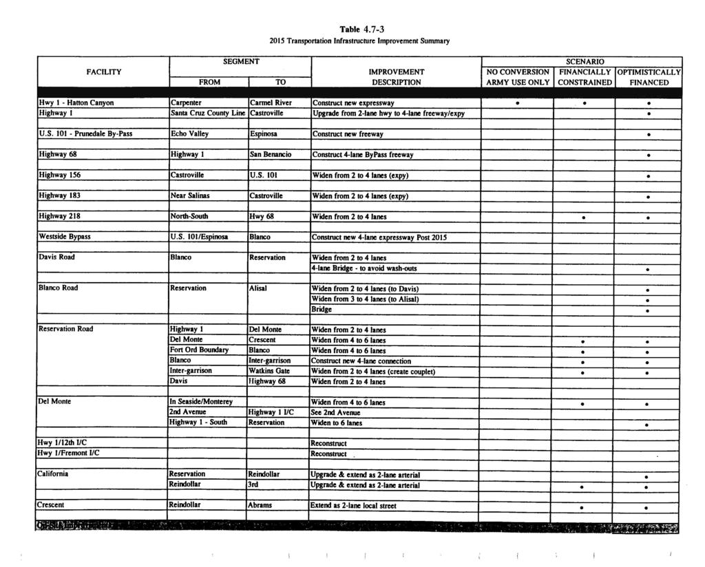
178
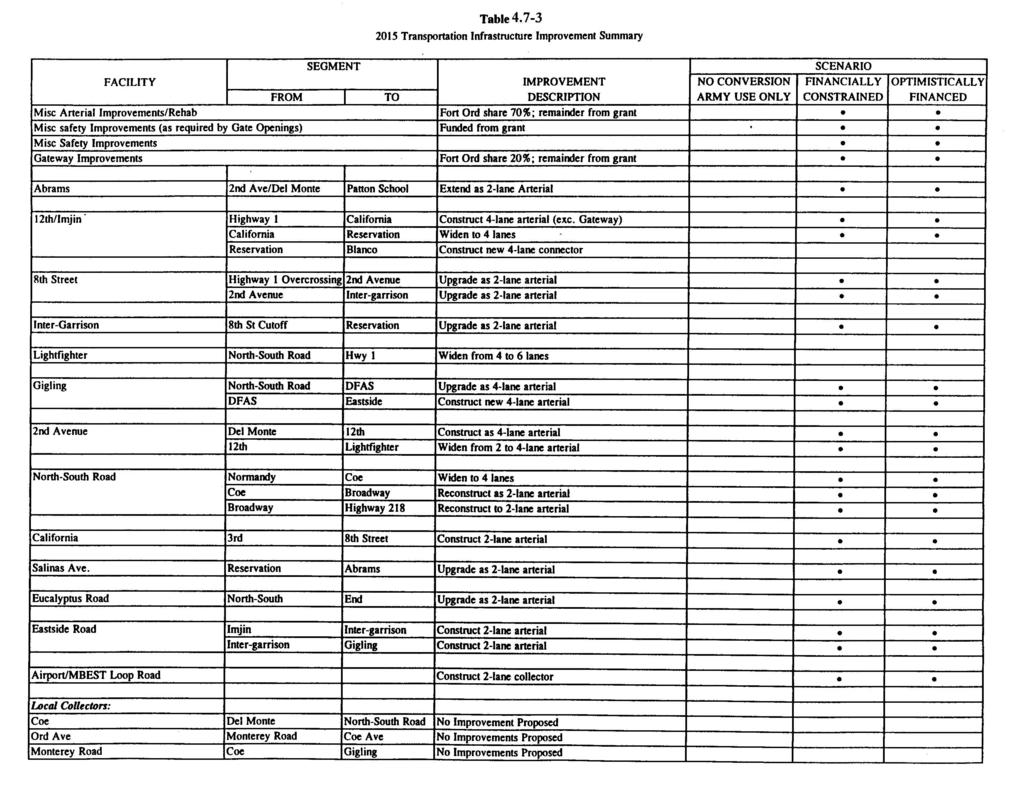
179
180
181 Table On-Site Facilities LOS Summary POM Use Roadway Segment Only Scenario 2015 Forecasted Daily Volume/LOS Financially Constrained Scenario Optimistic Financing Scenario 12th/Imjin State Highway 1 to California Avenue 20,800/D 19,900/D California Avenue to Eastside Road N/A 12,800/B 12,500/B Eastside Road to Reservation Road 19,400/B 7,00/B Blanco/Imjin Connector Eastside to Reservation N/A N/A 10,800/B 8th Street State Highway 1 Overpass to 2nd Avenue N/A 300/C 300/C 2nd Avenue to Inter-garrison 2,800/C 2,500/C Inter-garrison Road 8th Street to Gigling Connector N/A 3,500/B 3,000/B Lightfighter Gigling Coe Avenue Gigling Connector to Reservation Road 13,100/C 7,400/A State Highway 1 to North South Road General Jim Moore Boulevard North South Road General Jim Moore Boulevard to Eastside Ord Avenue to North South Road General Jim Moore Boulevard N/A 24,400/D 23,500/D N/A 16,900/B 15,200/B N/A 600/C 600/C 2nd Avenue Del Monte Blvd to 12th Street N/A 3,900/C 3,900/C North South Road General Jim Moore Boulevard 12th Street to Lightfighter 12,100/D 11,800/D Lightfighter to Gigling N/A 19,700/D 18,400/D Gigling to Coe/Eucalyptus 16,900/B 16,200/B Coe to Broadway 15,500/E 14,900/D Broadway to State Highway 218 5,500/A 5,400/A California Avenue Reservation Road to 12th Street N/A 9,600/D 13,200/D 12th Street to 8th Street 1,700/D 2,100/D Eastside Road Imjin to Gigling N/A 9,900/B 12,100/C Source: JHK Associates, 1996 The Optimistic Financing Scenario is assumed to represent the proposed project, since it reflects FORA s specific attempts in the Draft Fort Ord Reuse Plan to mitigate any impacts resulting from reuse. However, to the extent that the mitigating measures built into the plan for off-site improvements lie within the jurisdiction of agencies outside FORA s control, and cannot therefore be assured by FORA, the ultimate basis for existing impact significance at the regional level must remain the Constrained Financing Scenario. The Draft Fort Ord Reuse Plan policies and programs on transportation, which are cited below, are considered to promote the achievement of the Optimistic Financing Scenario and/or to provide additional mitigations which may reduce the impacts identified under the traffic scenarios. The latter type of mitigations would include transit development and Transportation Demand Management. Certified: June 13,
182 1. Impact: Increased Travel Demand on Regional Transportation System The proposed project would increase the demand placed on the regional transportation infrastructure and services that provide access to and from former Fort Ord. As would be expected, traffic volume increases related to former Fort Ord would be most significant for those facilities, such as Reservation and Blanco Roads, that are adjacent to or feed directly into former Fort Ord. The proposed project combined with regional traffic growth would result in worsening of several currently deficient roadway segments, and the degradation of several additional roadways to deficient levels (LOS E or F). These effects are discussed in the previous section and are summarized in Table With the proposed project, travel demand forecasts indicate that there would be approximately 185,000 person trips between former Fort Ord and the surrounding region by the year 2015; based on current mode choice characteristics in Monterey County, this would equate to over 130,000 vehicle trips. This number is estimated to increase to over 220,000 with buildout. For comparison, traffic counts taken at the former Fort Ord gates in 1990 (Army FEIS, 1993) suggest 58,000 such trips occurred. To a large extent, the attractiveness of former Fort Ord for redevelopment will depend on the ability of the regional transportation system to provide for efficient intra- and inter-regional travel. Efforts and improvements that address the efficient operation of the regional transportation system would be required. These may include roadway improvements, transit connections and demand management programs. The Draft Fort Ord Reuse Plan contains policies and programs related to each of these areas, as discussed below. Adding system capacity through roadway improvements represents the most direct means of mitigating the impacts of increased demand. The operating analysis presented in the previous section identified those roadway facilities which are forecast to operate at deficient service levels in 2015 (see Table 4.7-3), where roadway improvements would be needed to achieve or maintain acceptable service levels (see Table 4.7-2). The proposed regional roadway network includes a number of major improvement projects with varying levels of relationship to the reuse of former Fort Ord. In some instances, these improvements address existing system deficiencies or future deficiencies to which former Fort Ord has an insignificant contribution. With respect to Fort Ord, roadway facilities considered most critical include those most proximate to former Fort Ord (State Highway 1, Reservation Road, Del Monte Boulevard, Fremont Boulevard), those that connect to Salinas (State Highway 68, Blanco Road, Davis Road), and those to the north that provide connections to Santa Cruz and the Bay Area (State Highway 1, State Highway 156, U.S. 101). A key step in the transportation analysis process was the identification of former Fort Ord s contribution to the volume increases on the regional roadways examined in this study. This analysis, termed a nexus test, was used to determine former Fort Ord s fair share requirement for each of the proposed improvements. This information was in turn used to develop a funding mechanism by which former Fort Ord development would pay for its share of the impact on the regional transportation system. The Draft Fort Ord Reuse Plan also highlights the need for high quality connections between the regional network and the internal network. Provision of multiple connections would provide the opportunity for trips to be direct between their origin and destination. As a result, this will reduce vehicle miles of travel (VMT) and emissions and avoid overloading a small number of existing roadways. It is important that these connections be between arterial and higher class roadways to Certified: June 13, 1997
183 avoid excessive volumes on local streets. Furthermore, this interface must take into consideration the movement of goods along designated truck routes. The Draft Fort Ord Reuse Plan identifies the following policies and programs for the Cities of Marina and Seaside and for Monterey County, intended to mitigate the impact on regional roadway system improvements to the extent possible: Circulation Element Streets and Roads Policy A-1: FORA and each jurisdiction with lands at former Fort Ord shall coordinate with and assist TAMC in providing funding for an efficient regional transportation network to access former Fort Ord. Program A-1.1: FORA and each jurisdiction with lands at former Fort Ord shall provide a funding mechanism to pay for Fort Ord's share of impact on the regional transportation system. Program A-1.2: FORA and each jurisdiction with lands at former Fort Ord shall identify specific transportation issues that affect former Fort Ord and support and participate in regional and state planning efforts and funding programs to provide an efficient regional transportation effort to access former Fort Ord. Streets and Roads Policy B-1: FORA and each jurisdiction with lands at former Fort Ord shall design all major arterials within former Fort Ord to have direct connections to the regional network (or to another major arterial that has a direct connection to the regional network) consistent with the Reuse Plan circulation framework. Program B-1.1: Each jurisdiction shall coordinate with FORA to design and provide an efficient system of arterials consistent with (EIR) Figure (for year 2015 ) and (EIR) Figure (for buildout) in order to connect to the regional transportation network. Program B-1.2: Each jurisdiction shall identify and coordinate with FORA to designate local truck routes to have direct access to regional and national truck routes and to provide adequate movement of goods into and out of former Fort Ord. Transit service is also an essential component of the regional transportation system and can eliminate or delay the need for roadway improvements. It is especially important for the elderly, students, the disabled, and others who cannot drive or who do not have access to an automobile. Also, it can be an attractive transportation alternative for those who want to avoid the cost, stress, and delays of driving, and the nuisance of parking. Transit vehicles are generally less polluting on a per passenger basis, and can help to lessen roadway congestion. Bus and rail transit are both potentially viable options as transit service is expanded to serve former Fort Ord. The aggregate impact of an effective fixed-route transit system (i.e., rail) complemented by lower-capacity transit vehicles (i.e., buses) can be a logical and reasonable alternative to automobile use in areas where there is sufficient housing and employment. The Draft Fort Ord Reuse Plan contains the following policies and programs for the Cities of Marina and Seaside and Monterey County, which address mitigation of the impact on the regional transportation system: Certified: June 13,
184 Circulation Element Transit Policy A-1: Each jurisdiction with lands at former Fort Ord shall coordinate with MST to provide regional bus service and facilities to serve the key activity centers and key corridors within former Fort Ord. Program A-1.1: Each jurisdiction shall identify key activity centers and key corridors, coordinate with MST to identify bus routes that could serve former Fort Ord, and support MST to provide service responsive to the local needs. Program A-1.3: Each jurisdiction shall identify the need for transit/paratransit services for the elderly and disabled and coordinate with and support MST to implement the needed transit services. Transit Policy B-1: Each jurisdiction shall support TAMC and other agencies to provide passenger rail service that addresses transportation needs for former Fort Ord. Program B-1.1: Each jurisdiction shall support TAMC and other agencies to assess the need, feasibility, design and preservation of rights-of-way for passenger rail service that addresses transportation needs at former Fort Ord. Transit Policy C-1: Each jurisdiction shall support the establishment of intermodal centers and connections that address the transportation needs at former Fort Ord. Program C-1.1: Each jurisdiction shall coordinate with and support TAMC and MST to identify the need, location, and physical design of intermodal centers and regional and local transportation routes to connect with the intermodal centers. It is clear that the redevelopment of former Fort Ord, plus growth throughout the remainder of Monterey County and the region, would significantly increase the demand placed on the region's transportation infrastructure and services. To some extent, the increases in travel demand would be managed by building or improving transportation facilities and services, but there exists a variety of concepts and objectives that can be used to minimize the demand for vehicle trips as an alternative to increasing roadway capacity. Transportation Demand Management (TDM) of the Draft Fort Ord Reuse Plan, attempts to reduce the number of people who drive alone and to increase the number of people who walk and who use carpools, vanpools, transit, and bicycles. The approach being taken as part of the proposed project seeks to balance these two elements to achieve a transportation system that is both financially feasible and operationally acceptable. The TDM section programs for the Cities of Marina and Seaside and Monterey County address mitigation of the impact on the regional transportation system, as follows: Circulation Element Transportation and Demand Management Policy A-1: TDM programs shall be encouraged. Program A-1.1: Promote TDM programs at work sites Certified: June 13, 1997
185 Program A-1.2: Promote TDM programs in residential developments, retail centers, and other activity centers. Program A-1.3:Require new development to incorporate design features that will strengthen TDM programs. Program A-1.4:Enforce CMP trip reduction programs. The following policy and program for the Cities of Marina and Seaside and Monterey County relate to reducing the number of vehicle trips: Conservation Element Air Quality Policy A-3: Integrate the land use strategies of the California Air Resources Board s The Land Use - Air Quality Linkage - How Land Use and Transportation Affect Air Quality, into local land use decisions. Program A-3.1: Each jurisdiction shall plan and zone properties, as well as review development proposals to promote the Land Use-Air Quality linkage. This linkage includes, but is not limited to, enhancement of Central Business Districts, compact development patterns, residential densities that average above seven dwelling units per acre, clustered employment densities and activity centers, mixed use development, and integrated street patterns. The policies and programs described above would implement improvements and strategies that minimize former Fort Ord s impact on the regional transportation system and would result in former Fort Ord contributing its fair share for improvements needed to achieve or maintain acceptable LOS (LOS D or better) on the major regional roadways impacted by the reuse of former Fort Ord. In some areas, beneficial impacts could occur with the Optimistic Financing Scenario, as shown in Table However, even under the Optimistic Financing Scenario, some reductions in level of service to E or F would occur, resulting in significant adverse impacts. Furthermore, funding for the non-fort Ord share of off-site improvements may not be available, leading to a great number of significant impacts as indicated in the Constrained Financing Scenario in Table The policies and programs for transit, transportation demand management, and non-vehicular circulation within the Draft Fort Ord Reuse Plan would help to reduce impacts, but would not be sufficient to eliminate significant impacts due to deterioration of LOS on regional roadways. Mitigation: Amend Streets and Roads Policy A-1.2 to add the following wording: FORA shall review the options for distributing its financial contributions to all or selected off-site transportation improvements so as to maximize the effectiveness of these contributions in reducing traffic impacts to the regional roadway system. This mitigation measure would reduce the number or geographic distribution of locations sustaining deterioration in LOS, but some significant unavoidable impacts would remain. Certified: June 13,
186 Mitigation: A Development and Resource Management Plan (DRMP) to establish programs and monitor development at Fort Ord to assure that it does not exceed resource constraints posed by transportation facilities and water supply shall be established by FORA. 2. Impact: Increased Travel Demand Within Former Fort Ord The reuse of former Fort Ord would greatly increase the demand placed on the internal transportation system: Although an internal transportation system exists, it was designed for military uses and would be incompatible with the proposed civilian uses. With reuse, many roadways would be expected to operate at unacceptable service levels if maintained in their current condition. Furthermore, the designs of the existing roads are not consistent with accepted civilian-use standards related to safety and multimodal travel. The internal system would need to accommodate a portion of those trips going to or coming from outside the former Fort Ord boundaries, as well as those trips between points within former Fort Ord. Forecasts for the year 2015 indicate that former Fort Ord would generate approximately 290,000 person trip ends. This includes the 185,00 person trips to or from points outside former Fort Ord, as well as approximately 106,000 person trip ends between points within former Fort Ord (for internal trips, one trip involves two trip ends). For buildout, the number of person trip ends is expected to increase to over 550,000. Based on current mode choice characteristics, this equates to 205,000 vehicle trip ends in 2015 and 390,000 for buildout. The reuse of most areas provides the opportunity to redesign the transportation network to meet these new needs. This system must provide access to areas identified for redevelopment and do so as directly and efficiently as possible. Part of the efficiency is recognizing that different roads would serve different functional purposes. Another element is maintaining acceptable service levels to provide mobility. An efficient system operates with little or no congestion, thus limiting negative impacts such as delay, vehicle emissions, and intrusion into residential areas. The roadway network would form the backbone of the internal transportation system, but it is important to acknowledge the role of transit, non-motorized modes and transportation demand management in mitigating the impacts on the internal system and minimizing infrastructure requirements. As part of the travel demand forecasting and service level analysis conducted for the Draft Fort Ord Reuse Plan, an internal arterial roadway system was developed and tested. The extent of the network and size (number of lanes) of individual facilities were assessed. The goal of this process was to develop a network that met the access and circulation needs at an acceptable LOS, while minimizing infrastructure costs. The following policies and programs for the Cities of Marina and Seaside and Monterey County relate to mitigation of the impact on the internal transportation system: Circulation Element Streets and Roads Policy C-1: Each jurisdiction shall identify the functional purpose of all roadways and design the street system in conformance with Reuse Plan design standards. Program C-1.1: Each jurisdiction shall assign classifications (arterial, collector, local) for each street and design and construct roadways in conformance with the standards provided by the Reuse Plan (Table and Figure 4.7-4) Certified: June 13, 1997
187 Table Roadway Design Standards Rural Arterial Rural Local Urban Arterial Urban Collector No. of Lanes Design Traffic Volume Urban Local 1800 VPHPL <5000 ADT 1200 VPHPL <10000 ADT <2000 ADT Design Speed 65 MPH 55 MPH Preferred 40 MPH Min. Stopping SD Passing SD Alignment Minimum Radius Grade Profile Grade Cross Slope ROW Width (w/o slopes) Vertical Clearance Signing and Pavement Delineation 725 ft ft ft ft MPH MPH 25 MPH Min ft N/A ft N/A 150 ft N/A 1600 ft 300 ft 1500 ft 600 ft 300 ft 3-5% max for l level & rolling terrain 2% or standard superelevation per CalTrans HDM 6-9% for level & rolling terrain 2% or standard superelevation per CalTrans HDM 5-8% max 2% except, standard superelevation for expressway 9-11% max 0.40% min 0.50% min desirable 2% 110 ft 60 ft ft ft 56 ft 16.5 ft 15 ft ok if allowed by local ordinance Per CalTrans Traffic Manual 15 ft 16.5 ft 15 ft ok if allowed by local ordinance Per CalTrans Traffic Manual Per CalTrans Traffic Manual Key ADT Average Daily Traffic MPH Miles per Hour ROW Right of Way SD Sight Distance VPHPL Vehicles Per Hour Per Lane Source: Fort Ord Reuse Infrastructure Study, Traffic Safety Standards (HMH, Incorporated) 15 ft 15 ft Per CalTrans Traffic Manual Residential: <15% Comm/Indust: <8% <5% desirable 2% Per CalTrans Traffic Manual Certified: June 13,
188 Figure 4.7-4, Roadway Design Standards This figure can be found within the Maps section off the homepage of the FORA CD-ROM Application Certified: June 13, 1997
189 Program C-1.2: Each jurisdiction shall preserve sufficient right-of-way for anticipated future travel demands based on buildout of the FORA Reuse Plan. Program C-1.3: Each jurisdiction shall assign an appropriate threshold performance standard for its roadway system in order to measure the impacts of future growth on the system. Program C-1.4: Each jurisdiction shall design and construct the roadway network consistent with the phasing program identified in the Fort Ord Business and Operations Plan (Appendix B in the Reuse Plan). Program C-1.5: Each jurisdiction shall designate arterials and roadways in commercially zoned areas as truck routes. Streets and Roads Policy C-2: Each jurisdiction shall provide improvements to the roadway network to address high accident locations. Program C-2.1: Each jurisdiction shall collect accident data, identify and assess potential remedies at high accident locations and implement improvements to lower the identified high accident rates. As with the regional transportation system, transit service is an important component of the internal transportation system. Public transit can serve both longer, regional trips and shorter, local trips. An efficient and effective transit system requires the provision of both services and transit-related facilities. In most instances, these would be provided by region s public transit agency, Monterey- Salinas Transit (MST), however other entities may also provide complimentary services. For example, CSUMB has discussed plans to operate a shuttle between the campus and surrounding area for students, staff and visitors. It is important to coordinate such services with those provided by MST. The following policies and programs for the Cities of Marina and Seaside and Monterey County relate to mitigation of the impact on the internal transportation system and reducing the number of vehicle trips: Circulation Element Transit Policy A-1: Each jurisdiction with lands at former Fort Ord shall coordinate with MST to provide regional bus service and facilities to serve the key activity centers and key corridors within former Fort Ord. Program A-1.1: Each jurisdiction shall identify key activity centers and key corridors, coordinate with MST to identify bus routes that could serve former Fort Ord, and support MST to provide service responsive to the local needs. Program A-1.2: Each jurisdiction shall develop a program to identify locations for bus facilities, including shelters and turnouts. These facilities shall be funded and constructed through new development and/or other programs in order to support convenient and comprehensive bus service. Program A-1.3: Each jurisdiction shall identify the need for transit/paratransit services for the elderly and disabled and coordinate with and support MST to implement the needed transit services. Certified: June 13,
190 Program A-1.4: MST shall coordinate with the Santa Cruz Metropolitan Transit District to provide an integrated intercounty bus transit system. Program A-1.5: Existing rideshare programs shall be expanded to accommodate intercounty travel. Transit Policy C-1: Each jurisdiction shall support the establishment of intermodal centers and connections that address the transportation needs at former Fort Ord. Program C-1.1: Each jurisdiction shall coordinate with and support TAMC and MST to identify the need, location, and physical design of intermodal centers and regional and local transportation routes to connect with the intermodal centers. Conservation Element Air Quality Policy A-3: Integrate the land use strategies of the California Air Resources Board s The Land Use - Air Quality Linkage - How Land Use and Transportation Affect Air Quality, into local land use decisions. Program A-3.1: Each jurisdiction shall plan and zone properties, as well as review development proposals to promote the Land Use-Air Quality linkage. This linkage includes, but is not limited to, enhancement of Central Business Districts, compact development patterns, residential densities that average above seven dwelling units per acre, clustered employment densities and activity centers, mixed use development, and integrated street patterns. The potential future construction projects related to road widening may have environmental impacts. The general nature of these impacts are as follows: Highway 68 in Monterey. The project would entail four-laning most or all of the existing highway. The impacts would be primarily associated with the removal of existing trees. Del Monte Boulevard in Monterey/Seaside. This would primarily entail installation of turn movement lanes within developed areas. Building frontage area between existing structures and Del Monte Boulevard would be narrowed. There are no know potentially significant environmental impacts associated with this project. However roadwork would occur within the coastal zone. Highway 218 south of Seaside. This section of the roadway is adjacent to riparian habitat which flanks the highway. Further study of project impacts would be required and mitigations may be required. Reservation Road in Marina. This project would entail expansion to six lanes. Maritime chaparral and associated plant and animal species adjacent to Reservation Road would be potentially impacted. Highway 1 in Seaside/Sand City. This would entail 6-laning the existing 4-lane highway. Impacts would pertain to views and sand dune habitat. Highway 1 north of Castroville. This would entail 4-laning the existing 2-lane highway. The primary impacts would be related to loss of agricultural land. In the area of Moss Landing, the primary impact would relate to the slough and associated wildlife and encroachment into commercial areas Certified: June 13, 1997
191 Highway 156 east of Castroville. This would entail 4-laning the existing 2-lane highway. The primary impacts would be associated with the loss of agricultural land and trees. Noise impacts relative to the existing residential subdivision would be expected to be increased. Highway 183 north of Salinas. Located between Davis Road and Highway 156. This would entail 4- laning the existing 2-lane highway. The primary impact would be associated with the loss of agricultural land. Blanco Road west of Salinas. This would entail 4-laning the existing 2-lane highway. The primary impact would be associated with the loss of agricultural land. Highway 68 Bypass. Located north of the existing alignment and on Fort Ord property. The primary impacts would be associated with the noise impacts to existing residences and impacts to maritime chaparral and associated plant and animal species. Based on an approximately 6 mile length and an average road right-of-way width of 1,000 feet, it would be expected that approximately 740 acres of maritime chaparral and other habitat would be removed. Del Monte Boulevard in Marina. This would entail 6-laning the existing 4-lane frontage space between the existing structures and Del Monte Boulevard would be narrowed. A third critical element of the internal transportation system is facilities and services to support nonmotorized travel. Non-motorized modes of travel are an important focus for the former Fort Ord circulation system. The two most common non-motorized modes of travel are walking (pedestrian) and bicycling. Both pedestrian and bicycle travel are non-polluting, do not contribute to roadway congestion, do not require the higher level of capital that roadway infrastructure requires, and are healthy alternatives to vehicular travel. People often find walking and bicycling to be pleasant experiences when they have clearly defined facilities and feel safe using them. A critical factor in promoting pedestrian activity is to have land uses that permit trips that can be easily and safely walked. Some examples of pedestrian-friendly land uses are a mixture of uses located in proximity to one another, or transit stops placed near residential areas. Creating an interesting pedestrian environment with landscaping and minimal building setbacks in commercial areas also helps to encourage pedestrian activity. However, people will not take pedestrian trips if safe places to walk are not provided. By providing pedestrian facilities and routes, walking can be encouraged as an alternative to vehicle use. Similarly, bicycle transportation can be encouraged with the right mixture of land uses and good bicycle routes. To be a feasible alternative to driving, bicycling must be convenient and safe. The following policies and programs for the Cities of Marina and Seaside and Monterey County relate to mitigation of the impact on the internal transportation system. Circulation Element Pedestrian and Bicycles Policy A-1: Each jurisdiction shall provide and maintain an attractive, safe, and comprehensive pedestrian system. Program A-1.1: Each land use jurisdiction shall prepare a Pedestrian System Plan that includes the construction of sidewalks along both sides of urban roadways, sidewalks and pedestrian walkways in all new developments and public facilities, crosswalks at all signalized Certified: June 13,
192 intersections and other major intersections, where warranted, and school safety features. This plan shall be coordinated with adjacent land use jurisdictions, FORA, and appropriate school entities. Pedestrian and Bicycles Policy B-1: Each jurisdiction shall provide and maintain an attractive, safe and comprehensive bicycle system. Program B-1.1: Each jurisdiction shall prepare a Bicycle System Plan that includes an overall bicycle network consistent with the Reuse Plan (Figure 4.7-5) and local bicycle networks with the appropriate class of bikeways for each functional class of roadway. The Bicycle System Plan shall include appropriate design standards to accommodate bicycle travel and secure bicycle parking facilities at public and private activity centers. This plan shall be coordinated with adjacent land use jurisdictions, FORA, and appropriate school entities. Program B-1.2: Each jurisdiction shall review new development to provide bicycle system facilities consistent with the Reuse Plan and the Bicycle System Plan concurrently with development approval. Because these policies and programs contain improvements and strategies that will result in an internal transportation system that operates in a safe and efficient manner (LOS D or better), and provides for increased opportunities for effective alternatives to automobile travel, this impact is considered less than significant. Mitigation: None required. Impact: Increased Demand for Transit Services The reuse of Fort Ord will increase the demand for transit services. However, FORA will only to fund capital facilities such as new buses, a new transit center and two new park and ride lots. FORA does not propose to fund MST operations and maintenance. Based on MST information, this would leave MST with an unfunded $37.5 million operations deficit associated with Fort Ord development. O&M funding for transit agencies is traditionally the responsibility of the transit agency. Funds for transit operations and maintenance are derived through a combination of sources including federal Section 9 funds, State Transit Assistance (STA) and Transit Development Act (TDA) funds, and farebox revenues. In the event that FORA did contribute towards MST O&M funding, there would remain an outstanding unfunded amount associated with regional development. Since FORA cannot assure that funding will be obtained to support adequate transit services, even with funding of capital facilities, this impact should be considered significant and unavoidable Certified: June 13, 1997
193 Figure 4.7-5, Proposed Bicycle Network This figure can be found within the Maps section off the homepage of the FORA CD-ROM Application. Certified: June 13,
194 4.8 Climate and Air Quality Subsequent to preparation of the Army s FEIS and DSEIS, the Monterey Bay Unified Air Pollution Control District (MBUAPCD) prepared the CEQA Air Quality Guidelines, which establishes specific guidelines for analysis of potential air quality impacts. In order to be consistent with CEQA, this section of the Draft EIR reflects these guidelines. The previous impact analysis prepared for the Army could not be used in this Draft EIR because the premise of the analysis assumes full buildout in 2010 and uses different model methodology Environmental Setting Topography and Meteorology The proposed project is located in the North Central Coast Air Basin (NCCAB) which is comprised of Monterey, Santa Cruz and San Benito counties. The NCCAB lies along the central coast of California covering an area of 5,159 square miles. The northwest sector of the NCCAB is dominated by the Santa Cruz Mountains. The Diablo Range marks the northeastern boundary, and together with the southern extent of the Santa Cruz Mountains, forms the Santa Clara Valley which extends into the northeastern tip of the NCCAB. Farther south, the Santa Clara Valley evolves into the San Benito Valley, which runs northwest-southeast and has the Gabilan Range as its western boundary. To the west of the Gabilan Range is the Salinas Valley, which extends from Salinas at the northwest end to south of King City. The western side of the Salinas Valley is formed by the Sierra de Salinas, which also forms the eastern side of smaller Carmel Valley; the coastal Santa Lucia Range defines the western side of the valley. The semi-permanent high pressure cell in the eastern Pacific is the basic controlling factor in the climate of the NCCAB. In the summer, the high pressure cell is dominant and causes persistent west and northwest winds over the entire California coast. Air descends in the Pacific High forming a stable temperature inversion of hot air over a cool coastal layer of air. The onshore air currents pass over cool ocean waters to bring fog and relatively cool air into the coastal valleys. The warmer air aloft acts as a lid to inhibit vertical air movement. The generally northwest-southeast orientation of mountainous ridges tends to restrict and channel the summer onshore air currents. Surface heating in the interior portion of the Salinas and San Benito Valleys creates a weak low pressure, which intensifies the onshore air flow during the afternoon and evening. In the fall, the surface winds become weak, and the marine layer grows shallow, dissipating altogether on some days. The air flow is occasionally reversed in a weak offshore movement, and the relatively stationary air mass is held in place by the Pacific High pressure cell, which allows pollutants to build up over a period of a few days. It is most often during this season that the north or east winds develop to transport pollutants from either the San Francisco Bay area or the Central Valley into the NCCAB. During the winter, the Pacific High migrates southward and has less influence on the NCCAB. Air frequently flows in a southeasterly direction out of the Salinas and San Benito Valleys, especially during night and morning hours. Northwest winds are nevertheless still dominant in winter, but easterly flow is more frequent. The general absence of deep, persistent inversions and the occasional storm systems usually result in good air quality for the basin as a whole in winter and early spring Certified: June 13, 1997
195 Regulatory Setting Federal and State Ambient Air Quality Standards Historically, air quality laws and regulations have divided air pollutants into two broad categories of airborne pollutants: criteria pollutants and toxic air contaminants. In general, criteria pollutants are pervasive constituents such as those emitted in vast quantities by the use of fossil fuels. Toxic air contaminants are a category of air pollutants which are highly toxic in small doses. Toxic air contaminants are only briefly discussed herein because they are generally associated with commercial, industrial and agricultural sources and are regulated separately from criteria pollutants. Future proposed projects that are known to emit toxic air contaminants would be subject to a separate level of federal and state restrictions, oversight and application processes administered by the MBUAPCD. Criteria Pollutants. Both the State of California and the federal government have developed ambient air quality standards for the criteria pollutants, which include ozone, carbon monoxide, nitrogen dioxide, sulfur dioxide, and suspended particulates 10 microns and less. Table indicates both federal and state ambient air quality standards for criteria air pollutants. The state standards are more stringent than those of the federal standards. The relevant standards for which this proposed project is subject are the state standards. The state standards are not to be equaled or exceeded. When standards are exceeded an attainment plan must be prepared that outlines how an air quality district will comply. Generally, these plans must provide for district-wide emission reductions of 5% per year averaged over consecutive three-year periods. California also grants air districts explicit statutory authority to adopt indirect source regulations and transportation control measures, including measures to encourage or require the use of ridesharing, flexible work hours, or other measures that reduce the number or length of vehicle trips. Table Federal and State Ambient Air Quality Standards Pollutant Averaging Time Federal Standard California Standard Ozone 1 hour 0.12 ppm 0.09 ppm Carbon Monoxide Nitrogen Dioxide Sulfur Dioxide Particulates* (PM 10 ) 1 hour 8 hour 1 hour Annual 1 hour 24 hours Annual 24 hours Annual ppm 9.00 ppm ppm 0.14 ppm 0.03 ppm Key: ppm = parts per million; mg/m 3 = microns per cubic meter. PM 10 = Particulate matter less than 10 microns in diameter. * Promulgated in µg/m 3 only. Source: California Air Resources Board ppm 9.00 ppm 0.25 ppm 0.25 ppm 0.04 ppm µg/m µg/m µg/m µg/m 3 Certified: June 13,
196 Note also that Table of the FEIS summarizes the total existing (1992) criteria pollutants emission from all sources at former Fort Ord. Table summarizes emissions from former Fort Ord s permitted sources (i.e. sources for which the Army held a permit to operate from the MBUAPCD). The total pollutant emissions and total permitted emissions are compared in Table in the FEIS. During closure,the Army has transferred air permits to new owners or has maintained the equipment requiring such permits under active permits. obtained emission reduction credits as Ft Ord s emission sources were shut down. Emission reduction credits are surplus emission reductions that represent a permanent, enforceable and quantifiable decrease in emissions. Emission reduction credits are only needed in the MBUAPCD s permitting process for major sources of air emissions over 137 lbs/day of reactive organic gases or oxides of nitrogen. Emission reduction credits are important to the reuse of former Fort Ord lands because credits may be used to offset emissions associated with future economic growth (COE 1993). In general, emissions from population and economic growth related to Fort Ord are accommodated in the planning process rather than through emission reduction credits. The 1994 AQMP accommodates projected growth at Fort Ord through the year Toxic Air Contaminants. Toxic air contaminants are highly toxic in small doses. Examples include certain chlorinated hydrocarbons, certain metals and asbestos. Adverse health effects of toxic air contaminants may be carcinogenic (cancer-causing), short-term (acute) non-carcinogenic, and long-term (chronic) non-carcinogenic. Several hundred such pollutants are currently regulated by various federal, state and local programs. Toxic air contaminants are generated by a number of sources, including stationary sources, such as dry cleaners, gas stations and laboratories; mobile sources such as automobiles, aircraft, and railroads; natural sources, such as wind blown dust and wildfires; and area sources, such as forms, construction sites, or residential areas. The regulatory structure that deals with toxic air contaminants includes the National Emission Standards for Hazardous Air Pollutants, Assembly Bill 1807 (a.k.a., the Tanner Bill) and Assembly Bill 2588 (a.k.a., the Air Toxics Hot Spots Information and Assessment Act of 1987). The MBUAPCD regulates toxic air contaminants (TAC) from new or modified sources under Rule 1000, which applies to any source which requires a permit to construct or operate pursuant to District Regulation II and has the potential to emit any of 23 carcinogenic TAC or any of several hundred non-carcinogenic TACs listed in Title 8 of the California Administrative Code ( 5155). Rule 1000 also requires that sources of carcinogenic TACs install best control technology and reduce cancer risks to less than one incident per 100,000 population. Attainment Status of the NCCAB The NCCAB is designated a moderate nonattainment area for the federal ozone standard. However, the NCCAB has met the federal ozone standards since 1990, but until the Environmental Protection Agency formally redesignates the basin (expected to be by mid year 1996), it remains classified as nonattainment Certified: June 13, 1997
197 Under the California Clean Air Act (CCAA), the basin is also a moderate nonattainment area for the state ozone standard. The CCAA states that an ozone nonattainment area becomes nonattainmenttransitional if the state standard is not exceeded more than three times at any monitoring station in the air basin. Table summarizes the attainment status of the NCCAB. The MBUAPCD Air Quality Management Plan is designed to bring the NCCAB into attainment with state ozone standards. Table Attainment Status of the North Central Coast Air Basin Pollutant Federal State Ozone (O 3 ) Moderate Nonattainment Moderate Nonattainment Carbon Monoxide (CO) Unclassified/Attainment Monterey Co.-Attainment San Benito Co.-Unclassified Santa Cruz-Unclassified Nitrogen Dioxide (NO 2 ) Unclassified/Attainment Attainment Sulfur Dioxide (S0 2 ) Unclassified Attainment Inhalable Particulates(PM 10 ) Unclassified Nonattainment Source: MBUAPCD Existing Ambient Air Quality Ambient air quality in the project area is monitored at eight locations in the MBUAPCD. In addition, the National Park Service operates a station at the Pinnacles National Monument. Based on the monitoring data provided by the MBUAPCD, ozone concentrations exceeded state standards on nine days in 1992, sixteen days in 1993 and six days in 1994, eight days in 1995 and twenty one days in 1996 (Janet Brennan, pers.com,. November 4, 1996). The majority of these violations occurred at the Pinnacles monitoring station, where the State Ambient Air Quality Standards (AAQS) was exceeded on 20 different days between For PM 10, the NCCAB violated the state standard one time in 1992, seven times in 1993 and one time in 1994, and exceeded one day in 1995 (MBUAPCD 1995). Health Effects of Pollutants The primary air quality problems in the NCCAB are ozone and suspended particulates (PM 10 ). The following is a discussion of the health effects of Ozone and PM 10 pollutants. Ozone Ozone is produced by chemical reactions, involving nitrogen oxides (NO x ) and reactive organic gases (ROG), that are triggered by sunlight. Nitrogen oxides are created during combustion of fuels, while reactive organic gases are emitted during combustion and evaporation of organic solvents. Since ozone is not directly emitted to the atmosphere, but is formed as a result of photochemical reactions, it is considered a secondary pollutant. Ozone is a seasonal problem, occurring roughly from April through October. Certified: June 13,
198 Ozone is a strong irritant that attacks the respiratory system, leading to the damage of lung tissue. Asthma, bronchitis and other respiratory ailments, as well as cardiovascular diseases are aggravated by exposure to ozone. A healthy person exposed to high concentrations may become nauseated or dizzy, may develop a headache or cough, or may experience a burning sensation in the chest. Research has shown that exposure to ozone damages the alveoli (the individual air sacs in the lung where the exchange of oxygen and carbon dioxide between the air and blood takes place). Research has shown that ozone also damages vegetation. PM 10 PM 10 is small suspended particulate matter, 10 microns or less in diameter, that can enter the lungs. The major component of PM 10 are dust particles, nitrates, and sulfates. PM 10 is directly emitted to the atmosphere as a byproduct of fuel combustion, wind erosion of soil and unpaved roads. Small particles are also created in the atmosphere through chemical reactions. Particles greater than 10 microns in diameter can cause irritation in the nose, throat, and bronchial tubes. Natural mechanisms remove much of these particles, but particles less than 10 microns in diameter are able to pass through the body's natural defenses and the mucous membranes of the upper respiratory tract and enter into the lungs. The particles can damage the alveoli, tiny air sacs responsible for gas exchange in the lungs. The particles may also carry carcinogens and other toxic compounds, which adhere to the particle surfaces and can enter the lungs. Air Quality Rules Consistency with Air Quality Management Plan A consistency analysis of the proposed project with the adopted Air Quality Management Plan would be required as part of the approval process. This analysis and subsequent determination would be performed by the Association of Monterey Bay Area Governments (AMBAG). A consistency determination with AMBAG population figures is required to base a conclusion that consistency with the Air Quality Management Plan exists. As indicated in Table on page 5-11 of the PEIR, the AMBAG 2015 population projection for Fort Ord is 66,612 (of this 20,000 are students). The Reuse Plan forecast for Fort Ord for the year 2015 is 38,859 (of this 10,000 are students). Therefore, the Reuse Plan is consistent with the adopted forecast for the region. Furthermore, AMBAG s employment forecast (21,468) is above that of the Reuse Plan s (18,342). Therefore, the Reuse Plan is considered to be consistent with the adopted AMBAG forecast and is therefore also consistent with the Air Quality Management Plan. Transportation Conformity Rule The Conformity Rule will not apply to the proposed project. However, future transportation facilities subject to NEPA and/or CEQA, such as new highways or other projects that would be included in the Metropolitan Transportation Plan or are regionally significant, will be subject to the Conformity Rule Certified: June 13, 1997
199 MBUAPCD Rule 216 Future expansion of sewage treatment facilities associated with project buildout will require implementation of the requirements of Rule 216. Specifically, future project proponents of projects that would require expansion of treatment facilities will be required to prove their project to be consistent with the MBUAPCD s Air Quality Management Plan (AQMP) Environmental Impacts and Mitigation In the Monterey Bay Unified Air Pollution Control District s October, 1995 CEQA Air Quality Guidelines, CEQA and the State CEQA Guidelines identify several types of EIRs, each of which require a different level of air quality analysis. For example, program-level EIRs generally apply to multiple projects, phased projects, and/or regulatory programs. The air quality analysis for a program-level EIR will be less detailed than a project-level EIR because the effects cannot be predicted with the same level of accuracy. Program-level EIRs are prepared for projects that involve the implementation of a series of actions that can be characterized as one large project, such as multiple and phased projects, general plans, specific plans and zoning ordinances. A program-level EIR characterizes the overall program by analyzing the cumulative effects of the elements that comprise the proposed project (i.e., the Draft Fort Ord Reuse Plan). It is important to note that the air quality analysis of an EIR for a general plan will necessarily defer any unknown impacts related to subsequent projects to future EIRs or negative declarations (MBUAPCD 1995). Therefore, this air quality analysis is limited to the analysis of the existing physical conditions and the regulatory environment, as well as cumulative conditions. The cumulative analysis provided in Section 5.1 of this Draft EIR presents the results of the Caline 4 modeling exercise which was conducted for CO 2 based on cumulative traffic conditions (in the year 2015). The significance criteria for determining potential impacts are included below for reference only and should be used in conjunction with the MBUAPCD CEQA Air Quality Guidelines for future projects on the former Fort Ord. Significance Criteria Appendix G of the State CEQA Guidelines states that a proposed project would have a significant impact on climate and air quality if it results in: a violation of any ambient air quality standard which contributes substantially to an existing or projected air quality violation or exposes sensitive receptors to substantial pollutant concentrations. The following impact analysis considers both construction and operational activity effects to climate and air quality. Certified: June 13,
200 Criteria for Determining Construction Impacts The construction impacts relate to emissions associated with construction activities, which are temporary. All quality impacts can nevertheless be acute during construction periods, resulting in significant localized impacts to air quality. For example, the greatest source of construction-related impacts would be expected to be associated with disturbing large acreage of land, such as development of a golf course, or a large residential or business park development. Within the category of construction impacts, there are three primary emissions constituents of concern: Inhalable particulates, ozone and other pollutants. Inhalable Particulates (PM 10 ). Inhalable particulates associated with construction activities (e.g. excavations, grading, on-site construction vehicles) which directly generate 82 pounds or more of PM 10 would have a significant impact on local air quality. Because there are no specific projects associated with the Draft Fort Ord Reuse Plan, all future projects on former Fort Ord would be subject to an air quality analysis that determines the potential to exceed the 82 pound threshold (MBUAPCD 1995). A general rule of thumb to determine if a proposed future project may have a significant construction related impact is to determine if it would disturb 1.2 acres per day through grading and/or excavation. Ozone. Construction projects which temporarily emit precursors of ozone (i.e., reactive organic gases (ROG) or oxides of nitrogen (NOx), are accommodated in the emission inventories of stateand federally-required air plans and would not have a significant impact on the attainment and maintenance of ozone AAQS. The state and federal air plans are premised on the AMBAG population projections. Therefore, it is important to note that upon approval of the Final Reuse Plan and certification of its EIR by the FORA Board, AMBAG will commence with new population projections based on this approved Reuse Plan, whereby all future development on the former base will be consistent with the new AMBAG population projections. Other Pollutants. Construction projects which may cause or substantially contribute to the violation of other state or national AAQS or which could emit toxic air contaminants could result in temporary significant impacts. Potential toxic air contaminants associated with any future project on the former base will be an issue discussed and resolved at the time an application is submitted to the local jurisdiction. Criteria for Determining Operational Impacts Emissions from long-term operations generally represent a project s most substantial air quality impact. Table summarizes the project-level thresholds of significance for operational impacts by pollutant that are relevant to future projects. An exceedance of any threshold would represent a significant impact on local or regional air quality. Other Pollutants. Construction projects which may cause or substantially contribute to the violation of other state or national AAQS or which could emit toxic air contaminants could result in temporary significant impacts. Potential toxic air contaminants associated with any future project on the former base will be an issue discussed and resolved at the time an application is submitted to the local jurisdiction Certified: June 13, 1997
201 Future projects which would emit pollutants associated with objectionable odors in substantial concentrations could result in significant impacts if odors would cause injury, nuisance, or annoyance to a considerable number of persons or would endanger the comfort, health, or safety of the public. Table Thresholds of Significance Criteria for Pollutants of Concern Operational Impacts* POLLUTANT ROG NO x as NO 2 PM 10 CO SO x as SO 2 THRESHOLD(S) OF SIGNIFICANCE 150 lb/day (direct + indirect) 150 lb/day (direct + indirect) 82 lb/day (on-site)** AAQS exceeded along unpaved roads (off-site) LOS at intersection/road segment degrades form D or better to E or F or V/C ratio at intersection/road segment at LOS E or F increases by 0.05 or more or reserve capacity at unsignalized intersection at LOS E or F decreases by 50 or more*** 550 lb/day (direct)*** 150 lb/day (direct)** * Projects that emit other criteria pollutant emissions would have a significant impact if emissions would cause or substantially contribute to the violation of State or national AAQS. Criteria pollutant emissions could also have a significant impact if they would alter air movement, moisture, temperature, climate, or create objectionable odors in substantial concentrations. When estimating project emissions, local or project-specific conditions should be considered. ** District-approved dispersion modeling can be used to refute (or validate) a determination of significance if modeling shows that emissions would not cause or substantially contribute to an exceedance of State and national AAQS. *** Modeling should be undertaken to determine if the project would cause or substantially contribute (550 lb/day) to exceedance of CO AAQS. If not, the project would not have a significant impact. Source: Monterey Bay Unified Air Pollution Control District. 1. Impact: Potential Violation of Ambient Air Quality Standards Proposed future development may result in a violation of ambient air quality standards that contributes substantially to an existing or projected air quality violation or exposes sensitive receptors to substantial pollutant concentrations. The Draft Fort Ord Reuse Plan identifies the following policies and programs for the Cities of Marina and Seaside that address potential significant impacts to the NCCAB. Conservation Element Air Quality Policy A-1: Each jurisdiction shall participate in regional planning efforts to improve air quality. Program A-1.1: Each jurisdiction shall continue to cooperate with the MBUAPCD in carrying out the regional Air Quality Management Plan. Program A-1.2: Each jurisdiction shall coordinate with the TAMC to carry out the Congestion Management Plan. Certified: June 13,
202 Air Quality Policy A-2: Each jurisdiction shall promote local efforts to improve air quality. Program A-2.1: Each jurisdiction shall use the CEQA process to identify and avoid or mitigate potentially significant project specific and cumulative air quality impacts associated with development. As a Responsible Agency, the MBUAPCD oversees issuance of air pollution permits for toxic air contaminants, and thus is responsible for U.S. EPA health standards as they relate to air emissions. As a Responsible Agency, the MBUAPCD implements rules and regulations for many direct and area sources of criteria pollutants and toxic air contaminants. Program A-2.2: Each jurisdiction shall use Transportation Demand Management Ordinance and similar transportation measures to encourage commute alternatives. Air Quality Policy A-3: Integrate the land use strategies of the California Air Resources Board s The Land Use - Air Quality Linkage - How Land Use and Transportation Affect Air Quality, into local land use decisions. Program A-3.1: Each jurisdiction shall plan and zone properties, as well as review development proposal to promote the Land Use-Air quality link-age. This linkage includes, but is not limited to, enhancement of Central Business Districts, compact development patterns, residential densities that average above seven dwelling units per acre, clustered employment densities and activity centers, mixed use development, and integrated street patterns. Program A-3.2: Each jurisdiction shall zone high density residential and employment land uses to be clustered in and near activity centers to maximize the efficient use of mass transit. Because implementation of these policies and programs would help to limit the amount of air pollution generated within former Fort Ord and reduce potential violations of ambient air quality standards, this impact is considered less than significant. Mitigation. None required. 4.9 Noise Environmental Setting This section describes the noise environment in and around former Fort Ord in 1991, when the 7 th Infantry Division (IDL) was stationed at the base. For a more detailed discussion, refer to the Army s FEIS vol. I and the Other Physical Attributes Baseline Study of Fort Ord (US Army Corps of Engineers, Sacramento District 1992 e). The baseline study, hereby incorporated by reference, provides background information on environmental noise and includes a discussion of existing noise-sensitive locations, sources of noise, Department of the Army noise standards, and local agency noise standards for planning Certified: June 13, 1997
203 Terminology Sound level meters measure pressure fluctuations caused by sound waves. These measurements are reported in a logarithmic decibel (db) scale. Most sounds consist of a broad range of sound frequencies. Because the human ear is not equally sensitive to all frequencies, several different frequency-weighting schemes have been used to develop composite db scales that approximate the way the human ear responds to noise levels. The A-weighted db scale (dba) is the most widely used for this purpose. Typical A-weighted noise levels for various types of sound sources are summarized in Table The equivalent continuous sound level (L eq ) is used to develop a single-value description of average noise exposure over various periods. This average noise exposure often includes additional weighting factors for annoyance potential attributable to time of day or other considerations. The L eq data used for these average noise exposure descriptors are generally based on A-weighted sound level measurements. Average noise exposure over a 24-hour period is often presented as a day-night average sound level (DNL). DNL is calculated from hourly L eq values, with the L eq values for the nighttime period (10 p.m.-7 a.m.) increased by 10 db to reflect the greater disturbance potential from nighttime noises. The community noise equivalent level (CNEL) is also used to characterize average noise levels over a 24-hour period, with weighting factors for evening and nighttime noise levels. The L eq values for the evening period (7 p.m.-10 p.m.) are increased by 5 db, whereas L eq values for the nighttime period (10 p.m.-7 a.m.) are increased by 10 db. Except in unusual situations, the CNEL descriptor will be within 1.5 db of the L eq descriptor for the same set of noise measurements. Most people have difficulty distinguishing the louder of two noise sources that differ by less than db. Except in controlled laboratory conditions, an increase of less than 1 db cannot be perceived. Outside of laboratory conditions, an increase in noise of 3 db is typically considered to be the threshold of perceptibility. An increase of at least 5 dba can be described as being a distinctly noticeable increase and is typically required before a noticeable change in community response to noise can be expected. For this reason, an increase in noise of 5 db is often used as the threshold for a substantial noise increase. Noise Standards Relevant local noise standards are summarized below. Monterey County The noise element of the Monterey County General Plan identifies goals, objectives, and policies related to noise. The County uses the land use compatibility guidelines in Table to guide planning in the County. City of Marina The noise element of the City of Marina General Plan identifies goals, policies, and standards related to noise. The plan specifies the maximum acceptable sound levels for various land uses that are identified in Table Certified: June 13,
204 City of Seaside The noise element of the City of Seaside General Plan identifies goals, policies, and standards related to noise. The plan designates land uses exposed to exterior noise levels exceeding 60 db (DNL or CNEL) as being noise impacted. Table Weighted Sound Levels and Human Response Noise Source db(a)* Human Response Carrier Deck Jet Operation 140 Limit of Amplified Speech 130 Painfully loud Jet Takeoff (200 feet) Automobile Horn (3 feet) Riveting Machine Jet Takeoff (2,000 feet) Shout (6 inches) New York Subway Heavy Truck (50 feet) Pneumatic Drill (50 feet) Freight Traffic (50 feet) Garbage Disposal in Home 120 Threshold of feeling and pain Very annoying 90 Hearing damage (8-hour exposure) 80 Annoying Freeway Traffic (50 feet) 70 Telephone use difficult Air-conditioning Unit (20 feet) Light Automobile Traffic Speech in Normal Voice (15 feet) 50 Quiet In-house Movement of People, No Television or Radio Soft Whisper (15 feet) 30 Very quiet Recording Studio Very faint 0 Threshold hearing Key: * Typical A-weighted sound levels. The A-weighted decibel scale approximates the frequency response of the human ear. Source: U.S. Council on Environmental Quality Certified: June 13, 1997
205 Table Monterey County's Land Use Compatibility Criteria for Exterior Community Noise Noise Ranges (Ldn or CNEL) db Land Use Category I II III IV Passively used open spaces Auditoriums, concert halls, amphitheaters Residential low density single family, duplex, mobile homes Residential multi-family Transient lodging motels, hotels Schools, libraries, churches, hospitals, nursing homes Actively used open spaces playgrounds, neighborhood parks Golf courses, riding stables, water recreation, cemeteries Office buildings, business, commercial and professional Industrial, manufacturing, utilities, agriculture Notes: Noise ranges are applicable at the property boundary. Noise Range I Normally acceptable: Specified land use is satisfactory, based on the assumption that any buildings involved are of normal conventional construction, without any special noise insulation requirements. Noise Range II Conditionally acceptable: New construction or development should be undertaken only after a detailed analysis of the noise reduction requirements is made and needed noise insulation features included in the design. Conventional construction, but with closed windows and fresh air supply systems or air conditioning will normally suffice. Noise Range III Normally unacceptable: New construction or development should generally be discouraged. If new construction or development does proceed, a detailed analysis of the noise reduction requirements must be made and needed noise insulation features included in the design. Noise Range IV Clearly unacceptable: New construction or development should generally not be undertaken. Source: Monterey County Planning Department (1982). Table City of Marina Maximum Allowable Ambient Noise Exposure Zone of Property Receiving Noise Maximum L dn Residential Low density 60 Multifamily 65 Transient lodging 65 Schools, libraries, churches, hospitals 65 Auditoriums 60 Playgrounds, parks 65 Commercial 70 Industrial 75 Source: City of Marina (1985) Certified: June 13,
206 Noise Sensitive Receptors on Post and in the Vicinity of Former Fort Ord On-post noise-sensitive receptors located in the Main Garrison include family and troop housing, schools, existing CSUMB housing, and Silas B. Hayes Hospital. The East Garrison consists of buildings that are used primarily for storage purposes and is maintained to retain expansion capabilities. Civilian residential areas adjacent to former Fort Ord are the most sensitive off-post noise receptors. Substantial residential encroachment has occurred on the southwest, south, southeast, and northwest sides of former Fort Ord, with more planned for the future. In addition to residential areas, the City of Marina general plan noise element identifies additional sensitive receptors within the City including churches, schools, and open space/park areas. Sensitive receptors in the City of Seaside include schools, churches, parks, rest homes, and a library. Similar residential, park, school, and health care facilities are located in the City of Monterey, directly southwest of former Fort Ord, and in the City of Salinas, approximately 1 mile northeast of the northern boundary of former Fort Ord. A small number of residential and park uses are in Del Rey Oaks. Sand City is a commercial and industrial city with fewer than 100 residences. In addition to residential areas in the unincorporated county, the Monterey County general plan identifies school, park, and recreation areas as noise-sensitive areas. Sources of Noise Fort Ord 7 th IDL With the departure of the 7 th IDL, roadway traffic and aircraft using local airports remain the primary sources of noise in the area. City of Marina Traffic on roadways is the major source of noise within the City of Marina. Major highways and roadways within the city include: State Route (SR) 1; Del Monte Boulevard; Reservation Road; Blanco Road; and Imjin Road. Table summarizes existing traffic noise ( , depending on the roadway segment) modeling results for these roadways taken from the Other Physical Attributes Baseline Study of Fort Ord, California report. Freight rail service is provided to former Fort Ord and local industries via the Southern Pacific tracks that run parallel to SR 1 through former Fort Ord. A spur line parallel to Del Monte Boulevard in the Cities of Marina and Seaside provides service to these cities. Service to local industries is provided approximately two to three times a week. Because of the infrequency of train activity, noise from these operations is not a major concern Certified: June 13, 1997
207 Table Summary of Traffic Noise Analysis for Existing Conditions ( ) Roadway Segment Ldn at 100 Feet from Centerline of Roadway Distance (in feet) from Centerline of Roadway to Ldn Contour Line (db) 65 Ldn 60 Ldn 55 Ldn SR 1 SR 68 to Del Monte Avenue ,820 Del Monte Avenue to SR ,905 SR 218 to Ord Village interchange ,876 Ord Village Interchange to 0.5 mile north of Ord Village , mile north of Ord Village to Main Gate ,047 2,256 Main Gate to 12th Street Gate ,057 12th Street Gate to South Marina interchange ,015 2,188 South Marina interchange to Reservation Road ,491 SR 218 SR 1 to Fremont Boulevard Fremont Boulevard to SR SR 68 SR 1 to SR SR 218 to Toro Park Toro Park to Spreckels Boulevard ,096 Spreckels Boulevard to Blanco Road Reservation Road Del Monte Boulevard to Marina city limit Marina city limit to East Garrison Road East Garrison Road to SR Davis Road Blanco Road to Market Street Del Monte Boulevard Marina city limit to SR Blanco Road Reservation Road to Davis Road Fremont Boulevard South of SR SR 218 to Broadway Avenue Broadway Avenue to SR Broadway Avenue Del Monte Boulevard to Fremont Boulevard Fremont Boulevard to North South Road General Jim Moore Boulevard Del Monte Boulevard SR 218 to Broadway Avenue Broadway Avenue to Fremont Boulevard Imjin Road Abrams Drive to Reservation Road Inter-Garrison Road 8th Street to East Garrison Road North South Road General Jim Moore Boulevard North of Broadway Source: U.S. Army Corps of Engineers, Sacramento District (1992) Certified: June 13,
208 City of Seaside Traffic on roadways is the major source of noise within the City of Seaside. Table summarizes traffic noise modeling results for the following roadways taken from the Other Physical Attributes Baseline Study of Fort Ord. Major highways and roadways within the city include: SR 1; SR 68; SR 218; Fremont Boulevard; Del Monte Boulevard; North South Road General Jim Moore Boulevard; and Broadway Avenue. Aircraft activity around Monterey Peninsula Airport is another significant source of noise in Seaside. Figure depicts noise contours around the airport. The CNEL contour affects only a small portion of the southerly limits of the City of Seaside. According to the Federal Aviation Regulation Part 150 Noise Compatibility Program for the airport, no residential units in Seaside would require mitigation as a result of adoption of the Comprehensive Land Use Plan for the Monterey Peninsula Airport. As discussed previously, the Southern Pacific spur line paralleling Del Monte Boulevard provides service to the City of Seaside. Because of the infrequency of train activity, noise from these operations is not a major concern. Monterey County Unincorporated Monterey County, in the vicinity of former Fort Ord, does not have major or largescale noise problems. Traffic on highways and roadways is the primary source of noise in the county. Table summarizes traffic noise modeling results for the following roadways taken from the Other Physical Attributes Baseline Study of Fort Ord. Major highways and roadways in the county near former Fort Ord include: SR 1; SR 68; SR 183; SR 218; Fremont Boulevard; Del Monte Boulevard; North South Road General Jim Moore Boulevard; Reservation Road; Blanco Road; Imjin Road; Inter-Garrison Road; Davis Road; and Blanco Road Certified: June 13, 1997
209 Figure 4.9-1, 1991 CNEL Noise Contours for Monterey Peninsula Airport This figure can be found within the Maps section off the homepage of the FORA CD-ROM Application. Certified: June 13,
210 Aircraft activity around Monterey Peninsula Airport is another significant source of noise in the area. Figure depicts noise contours around the airport. Although industrial facilities, foodpacking plants, and several mining operations are located in the county, none of these operations creates noise conflicts in the vicinity of former Fort Ord. As discussed previously, the Southern Pacific spur line parallel to Del Monte Boulevard provides service to the City of Marina. Because of the infrequency of train activity, noise from these operations is not a major concern Environmental Impacts and Mitigation Significance Criteria According to the State CEQA guidelines, a project will normally have a significant effect on the environment if it: substantially increases the ambient noise levels for adjoining areas; or exposes people to severe noise levels. In practice, more specific professional standards have been developed to implement the intent of the State CEQA guidelines. This analysis judges impacts to be significant if the project would result in: the generation of noise that would conflict with applicable noise regulations or standards; a substantial increase in existing ambient sound levels for affected uses; or land uses that are incompatible because of noise. The Monterey County compatibility guidelines presented in Table are used in this evaluation to determine the significance of noise impacts. These guidelines are generally consistent with guidelines lines used by the Cities of Seaside and Marina. A noise level of 60 db-dnl is used as the significance threshold for residential uses. 1. Impact: Excessive Noise from Construction Activities Implementation of the proposed project may result in excessive noise from construction activities. Figure illustrates noise levels produced by various types of construction equipment. Properly maintained equipment would produce noise levels near the middle of the indicated ranges. The types of equipment that would be used for grading and constructing the proposed development would typically generate noise levels of A-weighted decibels (dba) at a distance of 50 feet while the equipment is operating. Construction equipment operations can vary from intermittent to fairly continuous, with several pieces of equipment operating concurrently. Assuming that a bulldozer (87 dba), backhoe (90 dba), grader (90 dba), and front-end loader (82 dba) are operating concurrently in the same area, peak construction-period noise would generally be about 94 dba at 50 feet from the construction site Certified: June 13, 1997
211 Figure 4.9-2, Construction Equipment Noise Ranges This figure can be found within the Maps section off the homepage of the FORA CD-ROM Application. Certified: June 13,
212 Noise impacts expected in the vicinity of an active construction site based on a composite source noise level of 94 dba at 50 feet are summarized in Table The atmospheric absorption parameter in Table reflects minimal absorption for typical construction equipment noise spectra (e.g., bulldozer, water truck). Locations within about 1,900 feet of a construction site would be exposed to occasional episodes of noise levels greater than 60 dba. Areas within about 740 feet of a construction site would be exposed to episodes of noise levels greater than 70 dba. However, such episodes of high noise levels would not be continuous throughout the day and would typically be restricted to daytime hours. Heavy trucks transporting construction materials to construction sites could be a source of excessive noise. The extent of potential noise impacts is highly variable depending on the intensity of construction on a given site, the amount of materials that must be trucked to the site, the number of access roads to the construction site, and the distance of noise-sensitive receptors to access roads. Table Distance Attenuation for Noise Near a Construction Site Receptor Distance (feet) Distance Attenuation Noise Level at Receptor (dba) Noise Contour Value (dba) Distance to db Contours Contour Distance (feet) Notes: ,000 1,500 2,000 2,500 3,000 4,000 5,280 7, ,115 1,918 2,902 4,006 5,365 7,407 The following assumption were used: Basic sound-level drop-off rate = 6.0 db/doubling. Atmospheric absorption coefficient = 0.5 db/100 meters. Reference noise level = 94 dba. Distance for reference noise level = 50 feet. Drop-off calculations include atmospheric absorption at 0.5 db/100 meters centered at reference distance. Except for sounds with highly distinctive tonal characteristics, noise from a particular source will not be identifiable when its incremental noise level contribution is significantly less than background noise levels. Contour distance calculations are most accurate within the decibel range of the direct attenuation calculations Certified: June 13, 1997
213 This construction would result in increased noise levels in areas around construction sites and along access roads to construction sites. These increased noise levels have the potential to adversely affect residences and other noise-sensitive land uses near these sites or roads. Ambient noise levels may be substantially increased or local noise standards may be exceeded. The Draft Fort Ord Reuse Plan identifies the following policies and programs for the Cities of Marina and Seaside and Monterey County that address noise from construction activity: Noise Element Noise Policy A-1: The City/County shall coordinate with the other local entities having jurisdiction within the former Fort Ord in establishing a consistent set of guidelines for controlling noise. Program A-1.1: The City/County shall adopt the land use compatibility criteria for exterior community noise shown in Table for application in the former Fort Ord. Program A-1.2: The City/County shall adopt a noise ordinance to control noise from nontransportation sources, including construction noise, that incorporates the performance standards shown in Table 4.9-6, for application in the former Fort Ord. Noise Policy B-1: The City/County shall ensure that the noise environments for existing residences and other existing noise-sensitive uses do not exceed the noise guidelines presented in Tables and 4.9-6, where feasible and practicable. Program B-1.1: The City/County shall develop and implement a program that identifies currently developed areas that are adversely affected by noise impacts and implement measures to reduce these impacts, such as constructing noise barriers and limiting the hours of operation of the noise sources. Program B-1.2: Wherever practical and feasible, the City/County shall segregate sensitive receptors, such as residential land uses, from noise generators through land use planning. Noise Policy B-2: By complying with the noise guidelines presented in Tables and 4.9-6, the City/County shall ensure that new development does not adversely affect existing or proposed uses. Noise Policy B-9: The City/County shall require construction contractors to employ noise-reducing construction practices. Because these policies and programs will limit how noise from construction can effect existing and planned noise-sensitive uses and how construction noise will be limited to normally acceptable levels, this impact is considered less than significant. Mitigation: None required. Certified: June 13,
214 Table Noise Level Performance Standards for Non-Transportation Noise Sources Cumulative Number of Minutes Allowed in Any One-Hour Time Period Exterior Noise Level Standards, dba Daytime (7:00 a.m. - 10:00 p.m.) Nighttime (10:00 p.m. - 7:00 a.m.) Note: Noise ranges are applicable at the property boundary. 2. Impact: Exposure of Existing Noise-Sensitive Land Uses to Excessive Traffic Noise and Substantial Increases in Ambient Noise Levels Implementation of the proposed project would result in the exposure of existing noise-sensitive land uses to excessive traffic noise and substantial increases in ambient noise levels. Projected traffic noise levels have been evaluated based on traffic conditions projected for 2015 with implementation of the proposed project. Table summarizes the modeled 2015 traffic noise day-night average sound levels at a fixed distance of 100 feet from the roadway centerline of each roadway segment analyzed. This table also summarizes the predicted distance to the 55-, 65-, and 70-dB contour lines. Traffic noise levels under ultimate buildout would be expected to be within 1 to 2 db of those projected for The traffic noise modeling results indicate that the noise criterion for residential land uses of 60 db would be exceeded within 100 feet of the centerline of many existing roadways and that substantial increases in noise (increases in excess of 5 db) would occur along some roadways. Noise-sensitive land uses (primarily residential) exist adjacent to all of the existing roadway segments evaluated. Some of the noise-sensitive land uses adjacent to these roadways include educational, religious, and healthcare facilities. Residential land uses vary from rural residential with scattered houses adjacent to roadways, to high-density urban residential development. Commercial, industrial, and recreational land uses also exist adjacent to some of the roads. However, impacts are evaluated based on the most sensitive land use that exists adjacent to a given roadway segment. The following policies and programs for the Cities of Marina and Seaside and Monterey County address roadwaytraffic noise on existing noise-sensitive land uses. Noise Element Noise Policy A-1: See above for description of this policy. Program A-1.1: See above for description of this program. Noise Policy B-1: See above for description of this policy. Program B-1.1: See above for description of this program. Program B-1.2: See above for description of this program Certified: June 13, 1997
215 Table Summary of Noise Modeling for the Draft Ford Ord Reuse Plan in 2015 Ldn at 100 from Centerline of Roadway Distance (in feet) from Centerline of Roadway to Ldn Contour Line Roadway Segment (db) 70 Ldn 65 Ldn 60 Ldn 55 Ldn State Route 1 SR 68 to Del Monte Avenue ,752 Del Monte Avenue to SR ,093 SR 218 to Fremont Boulevard ,082 2,330 Fremont Boulevard to Main Gate ,078 2,323 Main Gate to 12th Street Gate ,049 2,260 12th Street Gate to South Marina interchange ,025 2,209 (Del Monte Boulevard) South Marina (Del Monte Boulevard) to ,612 Reservation Road Reservation Road to North Marina (Del Monte ,485 Boulevard) North Marina (Del Monte Boulevard) to SR ,586 SR 156 to County line ,849 State Route 68 SR 1 to SR ,716 SR 218 to San Benancio Road ,209 Old Highway 68 San Benancio Road to Reservation Road ,621 Reservation Road to East Blanco Road ,314 SR 218 to San Benancio Road State Route 156 SR 1 to 0.1 miles east of Castroville Boulevard , miles east of Castroville Boulevard to U.S , State Route 183 U.S. 101 to Davis Road Davis Road to Espinosa Road ,139 Espinosa Road to SR ,328 State Route 218 SR 1 to Fremont Boulevard Fremont Boulevard to North South Road General Jim Moore Boulevard North South Road General Jim Moore Boulevard to SR Del Monte Boulevard SR 1 to Reservation Road SR 1 to Broadway Avenue Broadway Avenue to Fremont Boulevard SR 1 (South Marina) to Reservation Road Reservation Road to SR 1 (North Marina) Fremont SR 1 / SR 68 to Broadway Avenue Boulevard Broadway Avenue to SR Certified: June 13,
216 Broadway Avenue Del Monte Boulevard to Noche Buena Street Noche Buena Street to North South Road General Jim Moore Boulevard Reservation SR 1 to Del Monte Boulevard Road Del Monte Boulevard to Crescent Avenue Crescent Avenue to Imjin Road Imjin Road to Blanco Road Blanco Road to Inter-Garrison Road Inter-Garrison Road to Davis Road Davis Road to SR Blanco Road Reservation Road to Davis Road ,009 Davis Road to SR SR 68 to US Davis Road Reservation Road to Blanco Road Blanco Road to Rosi Street (SR 183) Rosi Street (SR 183) to US th SR 1 to California Avenue Street/Imjin Road California Avenue to Eastside Road th Street Eastside Road to Reservation Road SR 1 overpass to 2nd Avenue 2nd Avenue to Inter-Garrison Road Inter-Garrison 8th Street to Eastside Road Road Eastside Road to Reservation Road Lightfighter Road Gigling Road SR 1 to North South Road General Jim Moore Boulevard North South Road General Jim Moore Boulevard to Eastside Road Coe Avenue Ord Avenue to North South Road General Jim Moore Boulevard th Street to Lightfighter Road 2nd Avenue Del Monte Boulevard to 12th Street North-South Lightfighter Road to Gigling Road Road Gigling Road to Coe Road cont. Coe Road to Broadway Avenue Broadway Avenue to SR California Reservation Road to 12th Street Avenue 12th Street to 8th Street Eastside Road Imjin Road to Gigling Road Eucalyptus Road Presidio of Monterey Collector to North South Road General Jim Moore Boulevard Abrams Road Del Monte Boulevard to Imjin Road Monterey/Ord Fremont Boulevard to Gigling Road Certified: June 13, 1997
217 Presidio of Monterey Collector Notes: Gigling Road to Eastside Road Contour does not extend beyond the edge of the road. 2 Based on transportation data provided by Terry Klim (pers. comm.). Discussion pertaining to this program: strips of office space could buffer homes or school buildings from industrial buildings or high volume roadways. The use of parking lots as a buffer between residential uses and noise generators. Within industrial park areas, the heavy industrial use should be located as far from sensitive receptors as possible. Noise Policy B-2: See above for description of this policy. Because implementation of these policies and programs will limit traffic noise levels to normally acceptable levels at existing residential and other sensitive areas, this impact is considered less than significant. Mitigation: None required. 3. Impact: Exposure of New Noise-Sensitive Land Uses to Excessive Traffic Noise Implementation of the proposed project may result in the exposure of new noise-sensitive land uses to excessive traffic noise. Table summarizes the modeled 2015 traffic noise day-night average sound levels at a fixed distance of 100 feet from the roadway centerline of each roadway segment analyzed. This table also summarizes the predicted distance to the 55-, 65-, and 70-dB contour lines. Based on predicted 2015 traffic noise levels, traffic noise levels under ultimate buildout of the proposed project would be expected to be within 1 to 2 db of those projected for The traffic noise modeling results indicate that the noise criterion of 60 db for residential land uses would be exceeded within 100 feet of the centerline of many existing roadways and that substantial increases in noise (increases in excess of 5 db) would occur along some roadways. It is likely that these conclusions for 2015 conditions would also apply to plan buildout. The following policies and programs for the Cities of Marina and Seaside and Monterey County address roadway-traffic noise on new noise-sensitive land uses: Noise Element Noise Policy A-1: See above for description of this policy. Program A-1.1: See above for description of this program. Program B-1.1: See above for description of this program. Program B-1.2: See above for description of this program. Noise Policy B-2: See above for description of this policy. Noise Policy B-3: The City/County shall require that acoustical studies be prepared by qualified acoustical engineers for all new development that could result in noise Certified: June 13,
218 environments above noise range I (normally acceptable environment), as defined in Table The studies shall identify the mitigation measures that would be required to comply with the noise guidelines, specified in Tables and 4.9-6, to ensure that existing or proposed uses will not be adversely affected. The studies should be submitted prior to accepting development applications as complete. Noise Policy B-4: The City/County shall enforce the State Noise Insulation Standards (California Administrative Code, Title 24) which require that interior sound levels of 45 db- L dn be achieved for new multi-family dwelling, condominium, hotel, and motel uses. Noise Policy B-5: If, through site planning or the architectural layout of buildings, it is not feasible or practicable to comply with the noise guidelines presented in Tables and 4.9-6, the City/County shall require the following, as conditions to approval: that noise barriers be provided for new development to ensure that the noise guidelines are met; or that acoustical treatments be provided for new buildings to ensure that interior noise levels would be reduced to less than 45 db-l dn. Noise Policy B-6: If the ambient day-night average sound level (DNL) exceeds the normally acceptable noise range for residential uses (low density single family, duplex, and mobile homes; multi-family; and transient lodging), as identified in Table 4.9-6, new development shall not increase ambient DNL in residential areas by more than 3 dba measured at the property line. If the ambient DNL is within the normally acceptable noise range for residential uses, new development shall not increase the ambient DNL by more than 5 dba measured at the property line. Noise Policy B-7: If the ambient DNL exceeds the normally acceptable noise range for commercial (office buildings and business, commercial, and professional uses) or industrial (industrial, manufacturing, utilities, and agriculture) uses, as identified in Table 4.9-6, new development in commercial or industrial areas shall not increase the ambient DNL by more than 5 dba measured at the property line. Noise Policy B-8: If the ambient DNL exceeds the normally acceptable noise range for public or institutional uses (passively and actively used open spaces; auditoriums, concert halls, and amphitheaters; schools, libraries, churches, hospitals and nursing homes; golf courses, riding stables, water recreation areas, and cemeteries), as identified in Table 4.9-6, new development shall not increase ambient L dn by more than 3 dba measured at the property line. Because implementation of these policies and programs will limit traffic noise levels to normally acceptable level at planned residential and other sensitive areas, this impact is considered less than significant. Mitigation: None required Certified: June 13, 1997
219 Figure 4.9-3, Forecast Year 2010 CNEL 65 db Noise Contour for Monterey Peninsula Airport This figure can be found within the Maps section off the homepage of the FORA CD-ROM Application. Certified: June 13,
220 4. Impact: Exposure of New Noise-Sensitive Land Uses to Noise from Monterey Peninsula Airport and Marina Municipal Airport Implementation of the proposed project may result in exposure of new noise-sensitive land uses to noise from Monterey Peninsula Airport and Marina Municipal Airport. Figures and depict future noise contours from Monterey Peninsula Airport and Marina Municipal Airport. Sound levels in excess of 60 db may occur at planned noise-sensitive uses. The following policies and programs address aircraft noise on new noise sensitive land uses: Noise Element Noise Policy A-1: See above for description of this policy. Program A-1.1: See above for description of this program. Noise Policy B-2: See above for description of this policy. Noise Policy B-3: See above for description of this policy. Noise Policy B-4: See above for description of this policy. Noise Policy B-5: See above for description of this policy. Noise Policy B-6: See above for description of this policy. Noise Policy B-7: See above for description of this policy. Noise Policy B-8: See above for description of this policy. Because implementation of these policies and programs will limit aircraft noise levels to normally acceptable level at residential and other sensitive areas, this impact is considered less than significant. Mitigation: None required. 5. Impact: Exposure of Existing and Planned Noise-Sensitive Land Uses to Noise from Non-Transportation Sources, Including the Proposed Amphitheater, Peace Officers Training Facility, and the Transit Center Implementation of the proposed project may result in the exposure of existing and planned noisesensitive land uses to noise from non-transportation sources, including the proposed amphitheater, peace officers training facility, and the transit center. Proposed land uses that may potentially generate noise include the amphitheater, peace officers training facility, and the transit center. Use of these proposed facilities may expose existing and planned noise-sensitive land uses to excessive noise. The following policies and programs address the exposure of existing and proposed noise sensitive land uses to noise from non-transportation sources: Noise Element Noise Policy A-1: See above for description of this policy Certified: June 13, 1997
221 Figure 4.9-4, 2010 Noise Contours for Marina Airport This figure can be found within the Maps section off the homepage of the FORA CD-ROM Application. Certified: June 13,
222 This page intentionally left blank Certified: June 13, 1997
223 Program A-1.1: See above for description of this program. Program A-1.2: See above for description of this program. Noise Policy B-1: See above for description of this policy. Program B-1.1: See above for description of this program. Program B-1.2: See above for description of this program. Noise Policy B-2: See above for description of this policy. Noise Policy B-3: See above for description of this policy. Noise Policy B-4: See above for description of this policy. Noise Policy B-5: See above for description of this policy. Noise Policy B-6: See above for description of this policy. Noise Policy B-7: See above for description of this policy. Noise Policy B-8: See above for description of this policy. Because implementation of these policies will limit noise from these sources to normally acceptable levels at planned residential and other sensitive areas, this impact is considered less than significant. Mitigation: None required Biological Resources This section summarizes the description of biological resources at former Fort Ord that can be found in detail in the following documents: Flora and Fauna Baseline Study of Fort Ord, California (December 1992); Draft Fort Ord Disposal and Reuse Biological Assessment (February 1993); Supplement to the Draft Fort Ord Disposal and Reuse Biological Assessment (April 1993); Final Environmental Impact Statement, Fort Ord Disposal and Reuse (April 1993); Installation-Wide Multispecies Habitat Management Plan for Fort Ord, California (February 1994); and University of California-Fort Ord Step Center Biotic Study, Phase I (July 1994) Environmental Setting The former Fort Ord is located on California's central coast, a floristically diverse and unusual region. The wide range of climatic, topographic, and soil conditions at former Fort Ord contribute to the variety and uniqueness of the biological communities present. Eight broad categories of biological communities have been identified at former Fort Ord: beaches, bluffs & coastal strand; disturbed dune; coastal scrub; maritime chaparral; coast live oak woodland & savanna; native grassland; annual grassland and wetlands. A description of each of these communities follows. Biological Communities Coastal Strand and Dune Communities Certified: June 13,
224 Coastal strand and dune communities occur adjacent to Monterey Bay and west of State Highway 1. The native dune vegetation at former Fort Ord is mostly absent or degraded because of the aggressive growth of African ice plant. Native plants have been largely excluded except in scattered patches and at the far north end of the dunes. Five types of coastal strand and dune communities are recognized on former Fort Ord: beaches, bluffs and blowouts; disturbed dunes; coastal strand; dune scrub; and ice plant mats Most of the coastal areas at former Fort Ord support a stabilized dune community dominated by the non-native, aggressive ice plant - about 575 acres. This ice plant spreads as large, thick mats derived from individual seeds or vegetative clones. It crowds out native perennial species by taking up space, water, and light, and eliminates habitat for native annual species by stabilizing dune sands. Ice plant mats provide cover for some wildlife but they provide very little forage. The beaches, bluffs, and blowouts adjacent to Monterey Bay, and disturbed dunes comprise about 300 acres. These areas are generally devoid of vegetation because of the frequently moving substrates or intense ground disturbance in firing ranges, around structures, and in borrow pits. The vegetation that does establish in these areas consists of species tolerant of frequent ground disturbance such as sea rocket, beach primrose, soft chess, ripgut brome, annual fescue and kukuya grass. Common wading birds, such as sanderlings, plovers, and godwits occur along the beaches; California ground squirrels, deer mice, gray fox, red-tailed hawk, red-shouldered hawk, American kestrel, loggerhead shrike and red foxes occur in the disturbed dune. Coastal strand and dune scrub are of limited extent at former Fort Ord. Coastal strand occurs on approximately 89 acres and dune scrub comprises only 8 acres. These communities contain native perennial herbs and subshrubs including wild buckwheat, broadleaf paintbrush, Douglas' bluegrass, bush lupine and coyote brush. Wildlife diversity increases in the central dune scrub relative to other dune communities because soils are more stable and vegetation is more abundant. Maritime Chaparral Maritime chaparral is former Fort Ord's dominant vegetation type, covering approximately 12,500 acres. This vegetation is characterized by a wide variety of evergreen, sclerophyllus (hard-leaved) shrubs occurring in moderate to high density on sandy, well-drained substrates within the zone of coastal fog. Maritime chaparral integrates with coastal scrub and coast live oak woodland. This community is primarily dominated by shaggy-barked manzanita. Other species found in the shrub layer include chamise, Toro manzanita, sandmat manzanita, toyon, blue blossom ceanothus and Monterey ceanothus. The greatest diversity of wildlife species at former Fort Ord occur in the chaparral. Birds such as orange-crowned warbler, rufous-sided towhee, and California quail nest in the chaparral. Small mammals such as California mouse and brush rabbit forage in this habitat and serve as prey for gray fox, bobcat, spotted skunk and western rattlesnake. Many special-status plant species occur in this community, including Toro manzanita, sandmat manzanita, Hooker's manzanita, Monterey ceanothus, Eastwood's ericameria, Monterey spineflower and sand gilia Certified: June 13, 1997
225 Coastal Scrub Coastal scrub occurs near the coast on sandy soils and on inland hills on shallow soils. It integrates with grassland, maritime chaparral, coast live oak woodland and dune scrub. More inland areas of former Fort Ord support coastal sage scrub on rocky slopes as habitat patches within annual grassland and oak woodland. The vegetation is characterized by sparse to dense cover of softleaved, low-stature shrubs such as coyote brush, California sagebrush, and black sage. Wildlife using this habitat are similar to those species expected in the maritime chaparral. Approximately 550 acres of coastal scrub occurs at former Fort Ord. The coastal scrub at former Fort Ord is classified as Lucian or Central coastal scrub in Holland's (1986) classification. Lucian coastal scrub is locally abundant on the west side of the Santa Lucia range between Monterey and Point Conception. Coastal scrub is considered an important natural community because it provides habitat for several special-status plants, provides forage for wildlife, and stabilizes sandy soils and steep slopes. Coast Live Oak Woodland and Savanna The coast live oak is the dominant tree of woodlands and savannas at former Fort Ord. The live oak woodland is an open-canopied to nearly closed-canopied community with a grass or sparsely scattered shrub understory. Coastal forms of this community are characterized by short, windpruned trees exposed to persistent salt spray, which grow on sandy soils. Inland coast live oaks grow tall because they are protected by topographic position from the coastal weather influences. There are approximately 5,000 acres of oak woodlands at former Fort Ord. Oak habitats in general are important for a variety of wildlife species. Oaks provide nesting sites and cover for birds and cover for many mammals. Common wildlife species in coast live oak woodlands include black-tailed deer, California mouse, raccoon, California quail, scrub jay, and Nuttall s woodpecker. Red-tailed hawks and great-horned owls nest and roost in the inland coast live oaks, but probably make little use of the coastal oaks because the tightly spaced branches discourage them from entering the tree canopies. Oak woodlands and savannas are considered important natural communities because they provide a variety of ecological, aesthetic, and economic values. The extent of oak woodlands in California has declined as a result of agricultural conversion, urban development, fuelwood harvesting, and grazing activities. Because of this decline, the California Department of Forestry and Fire Protection, California Department of Fish and Game, California Native Plant Society, and The Nature Conservancy have identified the conservation and management of oak woodlands as a priority. State agencies are encouraged by California Senate Concurrent Resolution Number 17 (California Resolution Chapter 100, 1989) to preserve and protect native oak woodlands (sites with greater than five trees per acre) to the maximum extent feasible or to provide replacement plantings where Blue, Engleman, Valley or Coast Live Oak are removed. In its Joint Policy on Hardwoods, the Fish and Game Commission recognizes the importance of the hardwood resources (including oaks) in California and establishes joint policies with the California Department of Forestry for managing and maintaining these resources. In addition, several local jurisdictions maintain policies to preserve and protect native vegetation. Monterey County specifically addresses the preservation of oak trees through a County Ordinance (Ordinance No. 3420). Certified: June 13,
226 Grasslands The former Fort Ord supports mostly annual grassland comprised of non-native species but there are some areas where native perennial bunchgrasses are well-represented. Grasslands occur at the most inland, southeast section of former Fort Ord; at the Marina Municipal Airport; and as scattered, small meadows within coast live oak woodland and maritime chaparral. Approximately 4,240 acres of annual grasslands, and 475 acres of perennial grasslands occur at former Fort Ord. Annual grasslands dominated by introduced species such as slender wild oats, soft chess, and ripgut brome are the most common grassland community at former Fort Ord. Perennial grasslands are of two types at former Fort Ord: valley needlegrass grassland and blue wildrye. Valley needlegrass grassland, dominated by native purple needlegrass, is scattered throughout the southeastern portion of the installation. Small patches of blue wildrye grassland occur sporadically in the southeastern portion of the installation. Common wildlife species include California ground squirrel, Heerman s kangaroo rat, narrow-faced kangaroo rat, western meadowlark, and kestrel. Riparian Communities Riparian communities occur on the banks of seasonal or permanent creeks and drainages. There are approximately 37,170 linear feet of creeks and drainages total and 7,660 linear feet of creeks and drainages with riparian habitat. Riparian habitats at former Fort Ord are limited to the Salinas River, Toro Creek, Pilarcitos Canyon, and Merrill Ranch Canyon. The riparian communities along the Salinas River and Toro Creek are mixed riparian forests supporting a variety of tree species. The communities in Pilarcitos and Merrill Ranch Canyons are oak riparian forests dominated by coast live oaks with a dense understory of annual grasses. Riparian corridors are important wildlife habitat because they typically support the highest diversity of wildlife and provide movement corridors between different communities. Common wildlife species that occur in riparian communities include red-legged frog, Pacific tree frog, California slender salamander, Wilson s warbler, dark-eyed junco, striped skunk, coyote, and black-tailed deer. Wetland and Open Water Communities Four major types of wetland and open water communities are scattered throughout former Fort Ord: vernal pools, freshwater marshes, ephemeral drainages, and artificial ponds. Wetlands include sites of both permanent and seasonal inundation. The general distribution of these wetland and open water communities is illustrated on Figure Vernal pools are small, seasonally flooded basins in grasslands. Plant and wildlife species in these pools are specially adapted to live through winter and spring flooding and summer and fall drought. Common plant species include common spike-rush, hyssop loosestrife, and Vasey s coyote thistle. Common wildlife species include western spadefoot toad, garter snake, and northern rough-winged swallow. At former Fort Ord, vernal pools are most common on sites mapped as Antioch soils in isolated grassland patches within a matrix of maritime chaparral. The largest of these vernal pools is at Machine Gun Flats. Freshwater marshes are characterized by perennial, emergent plants that thrive in areas permanently flooded or saturated by fresh water. This community is usually found around freshwater ponds and Certified: June 13, 1997
227 Figure , Biological Communities at Fort Ord This figure can be found within the Maps section off the homepage of the FORA CD-ROM Application. Certified: June 13,
228 This page intentionally left blank Certified: June 13, 1997
229 perennial stream channels. Common plants include water smartweed and broad-leaved cattail. Common wildlife species include mallard, red-winged blackbird, and marsh wren. At former Fort Ord, freshwater marsh occurs around the perimeter of ponds and in patches in the channels of Toro Creek and the Salinas River. The former Fort Ord is bordered on the north by the Salinas River, which carries water year round. Most of the other drainages at former Fort Ord are intermittent or ephemeral. Intermittent streams carry water during the rainy season. Ephemeral streams are watercourses that convey runoff during and immediately after rainfall events to intermittent and perennial drainages. Drainages in Pilarcitos and Merrill Ranch Canyons are intermittent and ephemeral watercourses occur in areas adjacent to Toro Creek and the Salinas River. Poorly defined drainages are dominated by upland plants including soft chess, Italian wildrye, barley and wild oats. More well-defined drainages support more moisture-tolerant species such as rabbitfoots grass and Mediterranean barley. Deeply cut drainages that transport larger amounts of water support dense bank vegetation, including coast live oak, California blackberry, and coyote brush. Wildlife species found in drainages with at least seasonal moisture are similar to those occurring in vernal pools and freshwater marshes. Artificial ponds have been constructed throughout former Fort Ord to provide water for livestock and wildlife. Most of the ponds, however, occur in the southeastern portion of the base and are associated with the livestock grazing lease. The largest pond at former Fort Ord is Mudhen Lake. The immediate edges of most of these ponds are typically unvegetated because of widely fluctuating water levels. When ponds and reservoirs are full, mallards, cinnamon teal, canvasback, pintail and other waterfowl forage and rest in the open water. Other species that use freshwater marsh habitat around rivers and vernal pools will also use the limited marsh habitat available at ponds and reservoirs. Marine Community The marine environment of Monterey Bay is widely recognized as important habitat for an array of marine wildlife and has been approved for federal protection as part of the Monterey Bay National Marine Sanctuary. Approximately 27 species of marine mammals and 94 species of seabirds are known to occur in the Monterey Bay region, including nine special-status mammals, 17 special-status birds, and three endangered sea turtles. Most species occur as nonbreeding residents or spring and fall migrants. All the special-status birds may fly over the marine range area at former Fort Ord or float in the open water, and southern sea otters may occasionally feed in the marine range area; however, no important marine mammal haul-out or breeding areas or seabird nesting colonies occur at former Fort Ord. Special Status Species For purposes of this report, special status species are those which fall into the following categories: Plants or animals listed or proposed for listing as threatened or endangered under the federal Endangered Species Act. Certified: June 13,
230 Plants or animals that are Category C 1 or 2 candidates for possible future listing as threatened or endangered under the federal Endangered Species Act. Plants or animals listed or proposed for listing by the State of California as threatened or endangered under the California Endangered Species Act. Plants or animals that meet the definitions of rare or endangered under the California Environmental Quality Act. Plants listed under the California Native Plant Protection Act. Plants considered by the California Native Plant Society (CNPS) to be rare, threatened, or endangered in California. Plants listed by CNPS as plants about which more information is needed to determine their status and plants of limited distribution which may be included as special-status species on the basis of local significance or recent biological information. Animal species of special concern to the California Department of Fish and Game (CDFG). Botanical surveys during spring 1992 identified populations of 22 special-status plant species at former Fort Ord. Three of the species are listed as threatened or endangered under the federal or state endangered species acts: sand gilia, Monterey spineflower, and Seaside bird s beak. There are also 22 special-status wildlife species known to occur or have potential to occur in terrestrial and freshwater environments at former Fort Ord. Two species, Smith s blue butterfly and American peregrine falcon, are federally listed as endangered, and coastal populations of the western snowy plover are listed as threatened. The Army s FEIS for the disposal and reuse of former Fort Ord identified the need to develop and implement an installation-wide multispecies Habitat Management Plan (HMP) as a mitigation measure for impacts on vegetation, wildlife, and wetland resources, The HMP was developed with input from federal, state, local and private agencies and organizations concerned with the natural resources and reuse of former Fort Ord. The final HMP was completed in February 1994 and has been approved and signed by the U.S. Fish and Wildlife Service. The wildlife and plant species addressed in the HMP are a subset of the species analyzed in the FEIS. The species addressed in the HMP are those that were federally listed or proposed for listing as threatened or endangered, species with a significant portion of their range at former Fort Ord, or species with a significant portion of their local distribution at Fort Ord. Habitats important to these species also were included in the HMP. A list of the species and habitats addressed by the HMP is provided in Table There are other sensitive biological resources at former Fort Ord that were not addressed in the HMP. These resources typically include species or habitats that have limited legal protection status but may be considered sensitive for various reasons by CDFG, other resource agencies and interest organizations. These non-hmp species and habitats are listed in Table Certified: June 13, 1997
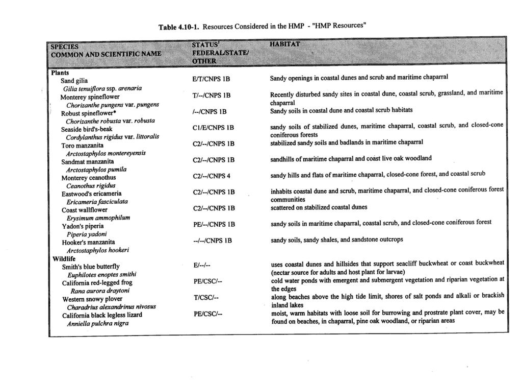
231
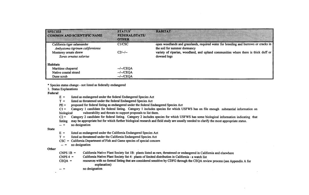
232
233
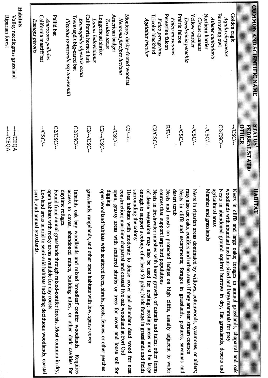
234