April 20, John Fleming, Division Head, Environmental Division
|
|
|
- Shanon Goodwin
- 5 years ago
- Views:
Transcription
 (S) Route 1, Section 14 Cross County Tier 2 Categorical Exclusion The Environmental Division has reviewed the referenced project and it falls within the definition of a Tier 2")
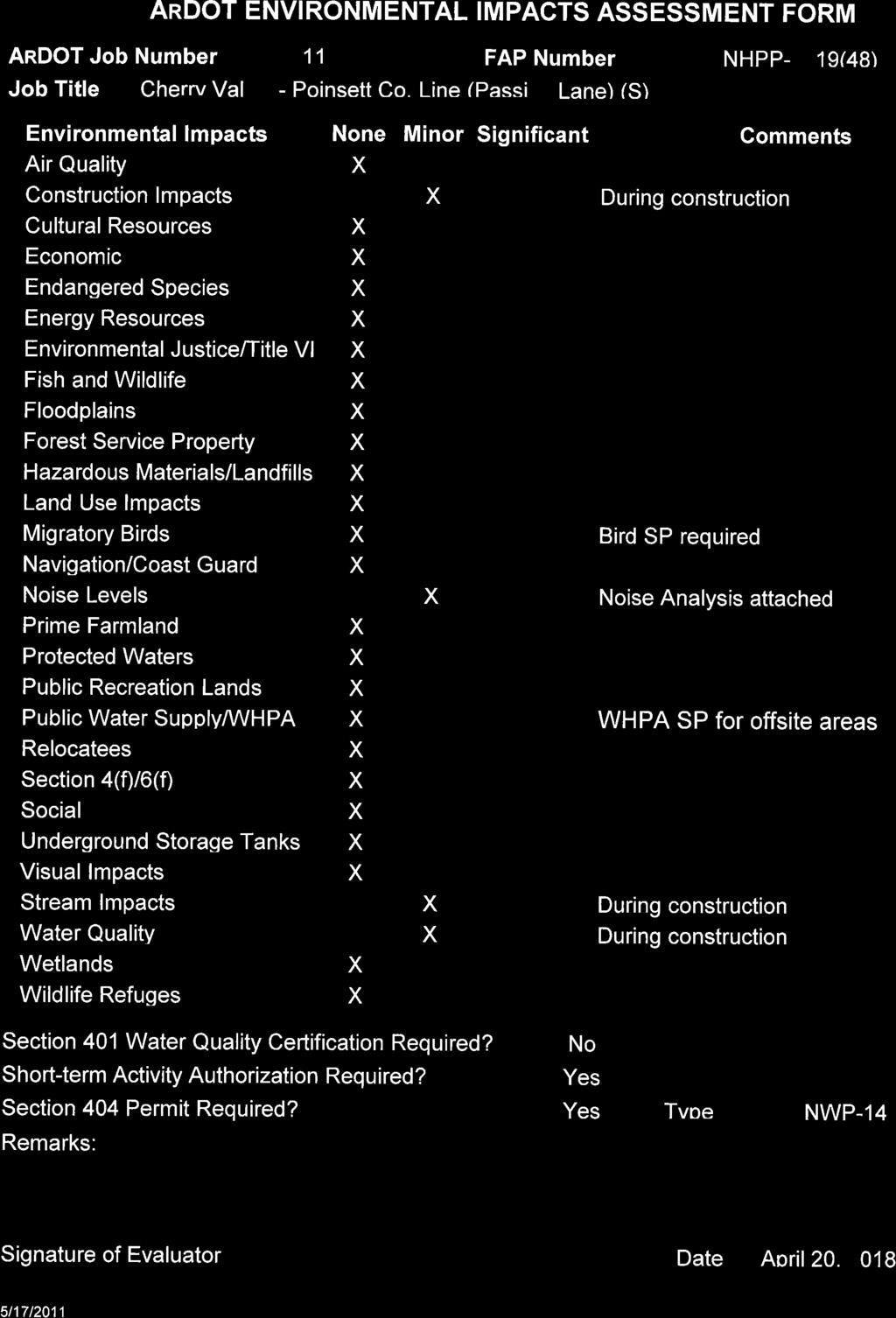
1 April 20, 2018 TO: Master Files FROM: John Fleming, Division Head, Environmental Division SUBJECT: Job Number FAP Number NHPP-0019(48) Cherry Valley - Poinsett Co. Line (Passing Lane) (S) Route 1, Section 14 Cross County Tier 2 Categorical Exclusion The Environmental Division has reviewed the referenced project and it falls within the definition of a Tier 2 Categorical Exclusion under 23 Code of Federal Regulations, Section , and the ARDOT/FHWA Memorandum of Agreement on the processing of Categorical Exclusions. A public hearing will not be offered for this project. The purpose of this project is to construct a northbound passing lane on Highway 1 north of Cherry Valley in Cross County. Total length of the project is 1.2 miles. A project location map is attached. The existing roadway consists of two 11-foot wide paved travel lanes with 8-foot wide paved shoulders. Existing right of way width is 60 feet. Proposed improvements include widening the existing lanes to 12 feet and adding a 12-foot wide passing lane on the northbound side. The paved shoulder widths will be 6 feet on the passing lane side and 8 feet on the opposite side of the road. New right of way width will average 80 feet. Approximately 1.82 acres of additional right of way will be required for this project. Design data for this project is as follows: Design Year Average Daily Traffic Percent Trucks Design Speed , mph , mph There are no relocatees, prime farmland, or environmental justice issues associated with this project. Field inspections found no evidence of existing underground storage tanks or hazardous

2
3 C Woodham Rd 1 End Job Hydrick Rd County Line Rd Poinsett County Cross County Union Pacific Railroad Begin Job Project Location! 1 1 B Cherry Valley 4 2 ³ 0 1,000 2,000 Feet ARDOT - Environmental GIS - Hopkins March 26, 2018 Job Cherry Valley - Poinsett Co. Line (Passing Lane) (Hwy. 1) Cross County Project Location


4
5 ARDOT JOB NUMBER NOISE ANALYSIS Fundamentals of Sound and Noise Noise is defined as an unwanted sound. Sounds are described as noise if they interfere with an activity or disturb the person hearing them. Sound is measured in a logarithmic unit called a decibel (db). The human ear is more sensitive to middle and high frequency sounds than it is to low frequency sounds, so sound levels are weighted to more closely reflect human perceptions. These Aweighted sounds are measured using the decibel unit db(a). Because the db(a) is based on a logarithmic scale, a 10 db(a) increase in sound level is generally perceived as twice as loud while a 3 db(a) increase is just barely perceptible to the human ear. Sound levels fluctuate with time depending on the sources of the sound audible at a specific location. In addition, the degree of annoyance associated with certain sounds varies by time of day, depending on other ambient sounds affecting the listener and the activities of the listener. The time-varying fluctuations in sound levels at a fixed location can be quite complex, so they are typically reported using statistical or mathematical descriptors that are a function of sound intensity and time. A commonly used descriptor of the equivalent sound level is Leq, which represents the equivalent of a steady, unvarying level over a defined period of time containing the same level of sound energy as the time varying noise environment. Leq(h) is a sound level averaged over one hour. For highway projects, the Leq(h) is commonly used to describe traffic-generated sound levels at locations of outdoor human use and activity (such as residences). Noise Impact Criteria Traffic noise impacts take place when the predicted traffic noise levels approach or exceed the noise abatement standard, or when the predicted traffic noise levels exceed the existing noise level by ten db(a) (decibels on the A-scale). The noise abatement standard of 67 db(a) is used for sensitive noise receptors such as residences, schools, churches, and parks. The term approach is considered to be one db(a) less than the noise abatement standard. The number of noise receptors was estimated for this project utilizing the Federal Highway Administration s Traffic Noise Model 2.5, existing and proposed roadway information, existing traffic information, and projected traffic levels for 2038.
6 ARDOT Job Noise Analysis Page 2 of 2 Traffic noise analyses Traffic noise analyses were performed for the project utilizing a roadway crosssection for Highway 1 consisting of three 12-foot paved travel lanes and 6 and 8- foot wide paved shoulders. Effects of Project The traffic noise estimates for the project resulted in a noise abatement distance of 125 feet from the centerline of Highway 1. Approximately three sensitive receptors are predicted to experience noise impacts resulting from noise levels that approach or exceed 67 db(a) during the design year. Traffic Noise Abatement Since noise impacts are predicted within 500 feet of the proposed project, the feasibility and reasonableness of potential noise abatement measures must be evaluated. Based upon ARDOT s Policy on Highway Traffic Noise Abatement, any noise abatement effort using barrier walls or berms is not warranted for this project. In order to provide direct access to the highway from adjacent properties, breaks in the barrier walls or berms would be required. These necessary breaks for highway access would render any noise barrier ineffective. To avoid noise levels in excess of design levels, any future receptors should be located a minimum of 10 feet beyond the distance that the noise abatement standard is projected to occur. This distance should be used as a general guide and not a specific rule since the noise will vary depending upon the roadway grades and other noise contributions. Any excessive project noise, due to construction operations, should be of short duration and have a minimum adverse effect on land uses or activities associated with this project area. In compliance with Federal guidelines, a copy of this analysis will be transmitted to the East Arkansas Planning and Development District for possible use in present and future land use planning.
7 United States Department of the Interior FISH AND WILDLIFE SERVICE Arkansas Ecological Services Field Office 110 South Amity Suite 300 Conway, AR Phone: (501) Fax: (501) In Reply Refer To: January 10, 2018 Consultation Code: 04ER SLI-0347 Event Code: 04ER E Project Name: ArDOT Cherry Valley - Poinsett Co. Line (Passing Lane) (S) Subject: List of threatened and endangered species that may occur in your proposed project location, and/or may be affected by your proposed project To Whom It May Concern: The enclosed species list identifies endangered, threatened, proposed, and candidate species, as well as proposed and final designated critical habitat, that may occur within the boundary of your proposed project and/or may be affected by your proposed project. The species list fulfills the requirements of the U.S. Fish and Wildlife Service (Service) under section 7(c) of the Endangered Species Act (Act) of 1973, as amended (16 U.S.C et seq.). This letter only provides an official species list and technical assistance; if you determine that listed species and/or designated critical habitat may be affected in any way by the proposed project, even if the effect is wholly beneficial, consultation with the Service will be necessary. The purpose of the Act is to provide a means whereby threatened and endangered species and the ecosystems upon which they depend may be conserved. Under sections 7(a)(1) and 7(a)(2) of the Act and its implementing regulations (50 CFR 402 et seq.), federal agencies are required to utilize their authorities to carry out programs for the conservation of threatened and endangered species and to determine whether projects may affect threatened and endangered species and/or designated critical habitat. More information on the regulations and procedures for section 7 consultation, including the role of permit or license applicants, can be found on our website. Please visit our website at for speciesspecific guidance to avoid and minimize adverse effects to federally endangered, threatened, proposed, and candidate species. Our web site also contains additional information on species life history and habitat requirements that may be useful in project planning.
8 01/10/2018 Event Code: 04ER E If your project involves in-stream construction activities, oil and natural gas infrastructure, road construction, transmission lines, or communication towers, please review our project specific guidance at The karst region of Arkansas is a unique region that covers the northern third of Arkansas and we have specific guidance to conserve sensitive cave-obligate and bat species. Please visit to determine if your project occurs in the karst region and to view karst specific-guidance. Proper implementation and maintenance of best management practices specified in these guidance documents is necessary to avoid adverse effects to federally protected species and often avoids the more lengthy formal consultation process. If your species list includes any mussels, Northern Long-eared Bat, Indiana Bat, Yellowcheek Darter, Red-cockaded Woodpecker, or American Burying Beetle, your project may require a presence/absence and/or habitat survey prior to commencing project activities. Please check the appropriate species-specific guidance on our website to determine if your project requires a survey. We strongly recommend that you contact the appropriate staff species lead biologist (see office directory or species page) prior to conducting presence/absence surveys to ensure the appropriate level of effort and methodology. Under the ESA, it is the responsibility of the Federal action agency or its designated representative to determine if a proposed action "may affect" endangered, threatened, or proposed species, or designated critical habitat, and if so, to consult with the Service further. Similarly, it is the responsibility of the Federal action agency or project proponent, not the Service, to make no effect determinations. If you determine that your proposed action will have no effect on threatened or endangered species or their respective critical habitat, you do not need to seek concurrence with the Service. Nevertheless, it is a violation of Federal law to harm or harass any federally-listed threatened or endangered fish or wildlife species without the appropriate permit. Through the consultation process, we will analyze information contained in a biological assessment that you provide. If your proposed action is associated with Federal funding or permitting, consultation will occur with the Federal agency under section 7(a)(2) of the ESA. Otherwise, an incidental take permit pursuant to section 10(a)(1)(B) of the ESA (also known as a habitat conservation plan) is necessary to harm or harass federally listed threatened or endangered fish or wildlife species. In either case, there is no mechanism for authorizing incidental take after-the-fact. For more information regarding formal consultation and HCPs, please see the Service's Consultation Handbook and Habitat Conservation Plans at endangered/esa-library/index.html#consultations. New information based on updated surveys, changes in the abundance and distribution of species, changed habitat conditions, or other factors could change this list. Please feel free to contact us if you need more current information or assistance regarding the potential impacts to federally proposed, listed, and candidate species and federally designated and proposed critical habitat. Please note that under 50 CFR (e) of the regulations implementing section 7 of the Act, the accuracy of this species list should be verified after 90 days. This verification can be
9 01/10/2018 Event Code: 04ER E completed formally or informally as desired. The Service recommends that verification be completed by visiting the ECOS-IPaC website at regular intervals during project planning and implementation for updates to species lists and information. An updated list may be requested through the ECOS-IPaC system by completing the same process used to receive the enclosed list. We appreciate your concern for threatened and endangered species. The Service encourages Federal agencies to include conservation of threatened and endangered species into their project planning to further the purposes of the Act. Please include the Consultation Tracking Number in the header of this letter with any request for consultation or correspondence about your project that you submit to our office. Attachment(s): Official Species List
10 01/10/2018 Event Code: 04ER E Official Species List This list is provided pursuant to Section 7 of the Endangered Species Act, and fulfills the requirement for Federal agencies to "request of the Secretary of the Interior information whether any species which is listed or proposed to be listed may be present in the area of a proposed action". This species list is provided by: Arkansas Ecological Services Field Office 110 South Amity Suite 300 Conway, AR (501)

11 01/10/2018 Event Code: 04ER E Project Summary Consultation Code: 04ER SLI-0347 Event Code: Project Name: Project Type: 04ER E ArDOT Cherry Valley - Poinsett Co. Line (Passing Lane) (S) TRANSPORTATION Project Description: Addition of a north bound passing lane to existing highway Project Location: Approximate location of the project can be viewed in Google Maps: Counties: Cross, AR
12 01/10/2018 Event Code: 04ER E Endangered Species Act Species There is a total of 3 threatened, endangered, or candidate species on this species list. Species on this list should be considered in an effects analysis for your project and could include species that exist in another geographic area. For example, certain fish may appear on the species list because a project could affect downstream species. See the "Critical habitats" section below for those critical habitats that lie wholly or partially within your project area under this office's jurisdiction. Please contact the designated FWS office if you have questions. Birds NAME Piping Plover Charadrius melodus Population: [Atlantic Coast and Northern Great Plains populations] - Wherever found, except those areas where listed as endangered. There is final critical habitat for this species. Your location is outside the critical habitat. Species profile: STATUS Threatened Clams NAME Fat Pocketbook Potamilus capax No critical habitat has been designated for this species. Species profile: STATUS Endangered Flowering Plants NAME Pondberry Lindera melissifolia No critical habitat has been designated for this species. Species profile: STATUS Endangered Critical habitats THERE ARE NO CRITICAL HABITATS WITHIN YOUR PROJECT AREA UNDER THIS OFFICE'S JURISDICTION.
13
14 ROADWAY DESIGN REQUEST Date Sent: March 20, 2018 Job Number FAP No. NHPP-0019(48) County Cross Job Name Cherry Valley Poinsett Co. Line (Passing Lane) (S) Design Engineer George W. Davison Environmental Staff Brief Project Description Adding passing lane to existing roadway. A. Existing Conditions: Roadway Width: 38-0 Shoulder Type/Width: 8 Paved Number of Lanes and Width: 2-11 Existing Right-of-Way: 60 Sidewalks? N/A Location: Width: Bike Lanes? N/A Location: Width: B. Proposed Conditions: Roadway Width: 50-0 Shoulder Type/Width: 6-8 Paved Number of Lanes and Width: 3-12 Proposed Right-of-Way: 80 Sidewalks? N/A Location: Width: Bike Lanes? N/A Location: Width: C. Construction Information: If detour: Where: N/A Length: D. Design Traffic Data: 2018 ADT: ADT: 6000 % Trucks: 11 Design Speed: 60 m.p.h. E. Approximate total length of project: 1.2 mile(s) F. Justification for proposed improvements: G. Total Relocatees: N/A Residences: N/A Businesses: N/A H. Have you coordinated with any outside agencies (e.g., FHWA, City, County, etc.)? Agency/Official Person Contacted Date