Mapping and estimating the potential for geological storage of CO2 in the Nordic countries a new project in NORDICCS
|
|
|
- Randolph Logan
- 5 years ago
- Views:
Transcription

1 Mapping and estimating the potential for geological storage of CO2 in the Nordic countries a new project in NORDICCS Karen L. Anthonsen NORDICCS Conference contribution D (1) November 2012
2
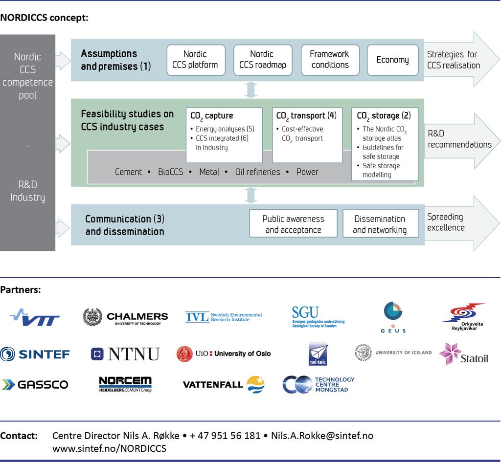
3 Summary Previous European projects mapped and estimated the potential storage for hydrocarbon fields, notmineable coal beds and saline aquifers. The European projects only included two Nordic countries (Norway and Denmark) and a unified database covering all of the Nordic countries does not exist. In November 2011, the Nordic countries research program - the Nordic Top-level Research Initiative (Nordic Innovation Center), launched NORDICCS Nordic Competence Centre for CCS. One of the Centers major tasks is the creation of a Nordic CO2 storage atlas. NORDICCS will build a database of geological information on potential storage sites, improve methods to quantify storage capacity and defining criteria to characterise a safe storage site. Further the option to store CO2 in basalts will be considered and potential areas mapped. Keywords Authors CCS, Nordic, storage potential, saline aquifers, basalts Karen Lyng Anthonsen, GEUS Geological Survey of Denmark and Greenland, Denmark, kla@geus.dk Date November 2012 About NORDICCS Nordic CCS Competence Centre, NORDICCS, is a networking platform for increased CCS deployment in the Nordic countries. NORDICCS has 10 research partners and six industry partners, is led by SINTEF Energy Research, and is supported by Nordic Innovation through the Top-level Research Initiative. The views presented in this report solely represent those of the authors and do not necessarily reflect those of other members in the NORDICCS consortia, NORDEN, The Top Level Research Initiative or Nordic Innovation. For more information regarding NORDICCS and available reports, please visit
4 ER 2: Mapping and Estimating the Potential for Geological Storage of CO 2 in the Nordic countries a new project in NORDICCS Karen Lyng Anthonsen, GEUS Geological Survey of Denmark and Greenland, Copenhagen, Denmark. kla@geus.dk Abstract: To reduce human impact on climate changes in the near future it is considered necessary to reduce CO 2 emissions from fossil fuel combustion. This fact has intensified research in methods capable of reducing emissions substantially and one of the methods being looked into is carbon capture and storage (CCS). CCS could relatively fast help to reduce CO 2 emissions form large point sources e.g. power stations, because the technology builds on already existing knowledge from oil and gas production. To be prepared for a possible future implementation of CCS it is, however, important to know where and how much CO 2 can be stored in the sub-surface. Several EU co-funded projects has mapped the potential for geological storage of CO 2 in Europe, beginning with the Joule II project in 1993, estimating a total storage capacity of 800 giga tonne (Gt), to GeoCapacity estimating a total storage capacity of 360 Gt in The results from these projects concluded that EU has sufficient storage capacity to store the yearly emission of CO 2 of 1.9 Gt from large stationary point sources. The European projects mapped and estimated the potential storage for hydrocarbon fields, not-mineable coal beds and saline aquifers. The GeoCapacity project concluded that the aquifers have by far the largest storage capacities with a total capacity of 325 Gt. The European projects only included two Nordic countries (Norway and Denmark) and a unified database covering all of the Nordic countries does not exist. It is clear, that the very different geology of the Nordic countries reflects the variation in CO 2 storage capacity, from the old basement rocks beneath Finland and most of Sweden, across the Caledonian mountains on-shore Norway, the large sedimentary basins in the sub-surface of Denmark and off-shore Norway to the active rift zone in Iceland. This was recently illustrated in a research study comprising an overview of the potential for applying CCS in the Nordic countries, where Finland and Sweden only had limited storage capacity; Denmark and especially Norway large CO 2 storage potential, and on Iceland the basaltic rocks offers the possibility to store CO 2 by mineral trapping, a method where the CO 2 is chemically attached to minerals in the basalts. In November 2011, the Nordic countries research program - the Nordic Top-level Research Initiative (Nordic Innovation Center), launched NORDICCS Nordic Competence Centre for CCS. One of the Centers major tasks is the creation of a Nordic CO 2 storage atlas. NORDICCS will build a database of geological information on potential storage sites, improve methods to quantify storage capacity and defining criteria to characterise a safe storage site. Further the option to store CO 2 in basalts will be considered and potential areas mapped.
5 Mapping and Estimating the Potential for Geological Storage of CO 2 in the Nordic countries a new project in NORDICCS Karen Lyng Anthonsen Geological Survey of Denmark and Greenland Danish Ministry of Climate, Energy and Building Nordic Geological Winter Meeting, Januar 9th 2012, Reykjavik
6 Outline of talk What is CCS? Key geological indicators for CO2 storage sustainability Mapping of potential CO2 storage options in Europe Results of European CO2 storage capacity projects Calculation of CO2 storage capacity - aquifers Nordic geological CO2 storage projects - NORDICCS
 Coal fields (unmineable)")
7 Carbon, Capture and Storage - CCS Emission source with CO2 capture facilities Transport Pipeline Ship Storage Hydrocarbon fields Aquifers (saline) Coal fields (unmineable) SINTEF
8 CO2 storage options Oil- and gas fields Limited storage capacity, but well-known geology and proven capability to retain hydrocarbons Possibility to use CO2 for enhanced oil/gas recovery (EOR/EGR) Aquifers (saline) Large storage volumes, but relatively unknown geology and therefore uncertainties about reservoir integrity and properties Coal fields Very limited storage capacity and injection rates, but possible to use CO2 for production of methane Mineral trapping Research area with large perspectives

9 Trapping mechanisms Stratigraphical trapping Porous layer bounded by tight seal Structural trapping Porous layer topped by tight seal Structural trapping Porous layer in fault contact with seal
10 Key geological indicators for storage site suitability Reservoir Properties Positive Indicators Cautionary Indicators Depth >800 m, <2500 m <800 m, >2500 m Reservoir thickness >50 m <20 m Porosity >20% <10% Permeability >500 md <200 md Salinity >100 gl 1 <30 gl 1 Stratigraphy Uniform Complex lateral variation and complex connectivity of reservoir facies Capacity Caprock Properties Estimated effective capacity much larger than total amount of CO 2 to be injected Estimated effective capacity similar to total amount of CO 2 to be injected Lateral continuity Stratigraphically uniform, small or no faults Thickness >100 m <20 m Lateral variations, medium to large faults Chadwick et al., 2008

11 CO2 density changes with increasing depth

12 The relationship between porosity and permeability with depth, exemplified by a Danish reservoir sandstone Porosity decreases with depth Permeability decreases with decreasing porosity The optimal depth window for CO2 storage is meter
13 CO2 storage capacity projects Joule II finalised 1993 The joule II project: The underground disposal of carbon dioxide All Europe GESTCO finalised 2003 Geological Storage of CO2 from Combustion of Fossil Fuel Belgium, Denmark, France, Germany, Greece, Netherlands, Norway, UK Castor (WP 1.2) finalised 2006 Bulgaria, Croatia, Czech Rep., Hungary, Poland, Romania, Slovakia, Slovenia GeoCapacity finalised 2008 Assessing European Capacity for Geological Storage of Carbon Dioxide Bulgaria, Croatia, Czech Rep., Denmark, Estonia, France, Germany, Greece, Hungary, Italy, Latvia, Lithuania, Netherlands, Poland, Romania, Slovakia, Slovenia, Spain, UK (Albania, FYROM, Bosnia-Herzegovina, Luxembourg)

14 Mapping of CO2 storage capacity in Europe
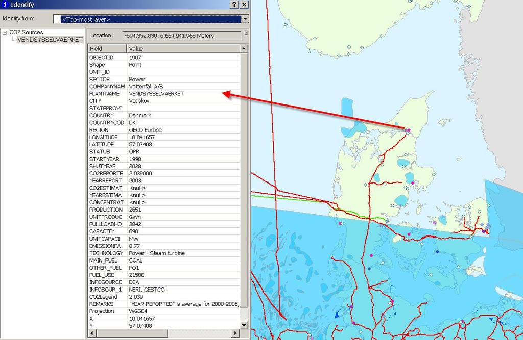
15 Mapping of emission sources and infrastructure Stationary CO2 emission sources exceeding 100 kt CO 2 / year Data sources: annual reports for the EU ETS national allocation plans qualified estimations where data not available Infrastructure mapping pipelines
16
17 CO2 emission sources
18 Clustered CO2 emission sources
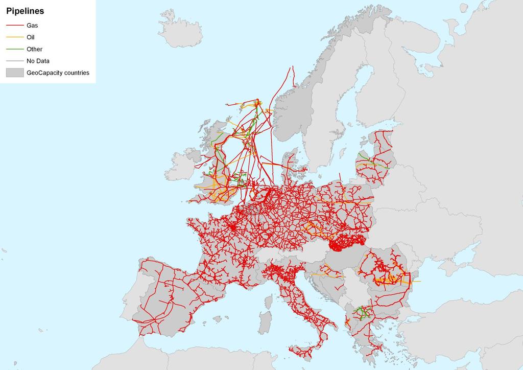
19 Pipelines
20 Potential CO2 storage sites
21 Results from the EU projects Joule II estimated a total storage capacity for Europe of 800 Gt GeoCapacity Emissions from large point sources in the GeoCapacity database is 1.9 Gt CO 2 /year (1,900,000,000 tones) Total European storage capacity in GeoCapacity database is 360 Gt CO Gt in aquifers 32 Gt in hydrocarbon fields 2 Gt in unmineable coal beds Offshore storage capacity is 244 Gt, onshore capacity is 116 Gt CO 2 Almost 200 Gt is located offshore Norway Total conservative European storage capacity is 117 Gt CO 2 96 Gt in aquifers 20 Gt in hydrocarbon fields 1 Gt in unmineable coal beds

22 Calculation of CO2 storage capacity for aquifers

23 Theoretical vs. effective capacity Theoretical capacity: M CO 2t = A h CO 2r Effective capacity: M CO 2e = A h CO 2r S eff M CO 2: Storage capacity A: Area of aquifer h: Height net to gross ratio : Average reservoir porosity CO 2r: CO 2 density at reservoir conditions S eff : Storage efficiency factor - depends on connectivity to surrounding aquifer Based US DOE methodology S eff for regional aquifers is 2%

24 Open and semi-closed structures
25 General considerations for saline aquifers Distinguish between estimates for bulk volume of regional aquifers and estimates for individual stratigraphic/structural traps For estimates based on the bulk volume of regional aquifers a storage efficiency factor of 2% based on work by US DOE is suggested For trap estimates the choice of storage efficiency factor depends on whether the aquifer system is open, semi-closed or closed For traps in open or semi-closed aquifer systems we suggest a rule-of-thumb approach with values for the storage efficiency factor in the range between 3-40% Storage capacity estimates should always be accompanied with information on assumptions and approach for storage efficiency factor
26 Techno-Economic Resource-Reserve pyramid Practical capacity with economic and regulatory barriers applied to effective capacity and with matching of sources and sinks: Site specific efficiency factor from reservoir simulations Effective capacity with technical/geological cut off limits applied to theoretical capacity: Detailed estimates with evaluated efficiency factor Theoretical capacity including large uneconomic/unrealistic volumes: Estimates without efficiency factor
27 Techno-Economic Resource-Reserve pyramid? Practical capacity Effective capacity GeoCapacity (2008) Gt Theoretical capacity Joule II (1993) 800 Gt
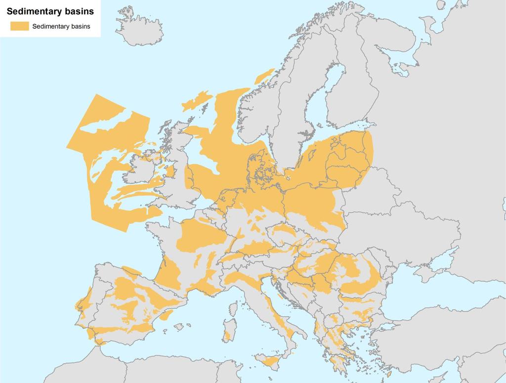
28 Sedimentary basins
29 Sedimentary basins - offshore

30 Why a Nordic CO2 Storage Atlas? NORDICCS
31 Nordic mapping projects 2010 Oljedirektoratet (Norwegian Petroleum Directorate) CO 2 storage atlas for Norway published December The Nordic Top-level Research Initiative announces a call for proposals to support the establishment of a Nordic User Driven Competence Centre for realisation of Carbon Capture and Storage NORDICCS is granted 35 mill. NOK for a 4 year period - One of the major tasks is the creation of a Nordic CO 2 Storage Atlas.
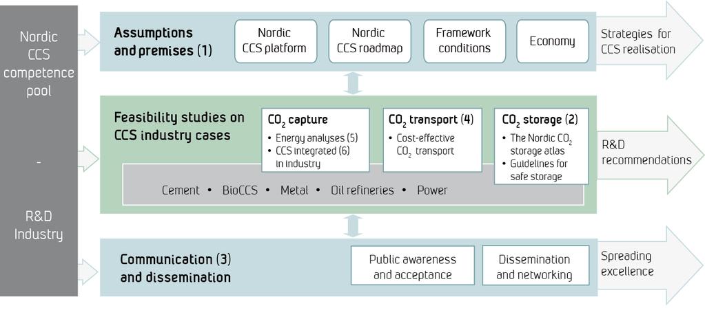
32 NORDICCS is the Nordic CCS research and innovation platform involving the major CCS stakeholders in the five Nordic countries. NORDICCS Activities Integrating activities Building the Centre Defining a common basis Joint R&D Collaborative research and development activities Sharing expertise and research infrastructure Spreading excellence Communication to the general public Structured information dissemination among partners

33 NORDICCS
34 NORDICCS Partners working with the Nordic storage atlas: GEUS, SINTEF-PR, University of Oslo, SGU, University of Iceland, Reykjavik Energy The Nordic CO2 Storage Atlas Review and update existing data bases and generate The Nordic CO 2 Storage Atlas Guidelines for Safe Storage in the Nordic area Define criteria, methods and timeframe for CO2 storage in the Nordic area Safe Storage Modelling Investigate the filling capacity for selected storage site cases and narrow the uncertainty in storage capacity assessment

35 Expected result in 2015 a GIS based Nordic CO2 storage atlas NORDICCS


36

37 Thank you! IGME 5000