Air Quality Analysis Technical Memorandum
|
|
|
- Flora Jacobs
- 5 years ago
- Views:
Transcription
, Florida July")
1 Air Quality Analysis Technical Memorandum Segment 3: State Road 400 (SR 400)/Interstate 4 (I-4) from One Mile East of SR 434 to East of SR /US Seminole County (77160), Florida July 2016
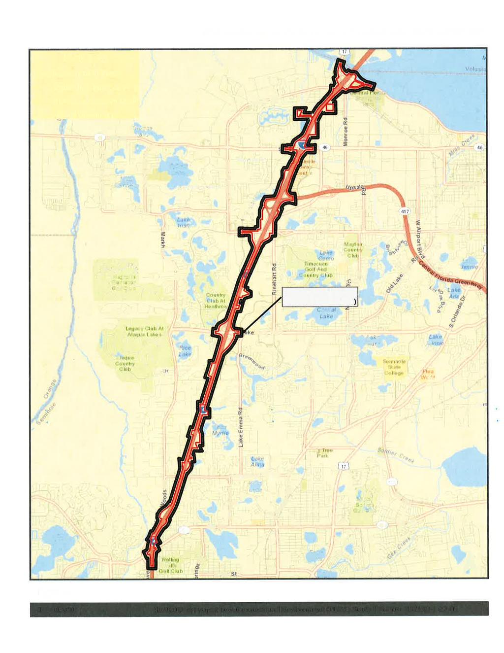
2 Air Quality Analysis Technical Memorandum AIR QUALITY ANALYSIS TECHNICAL MEMORANDUM Date: July 2016 To: From: FDOT District 5 through HNTB Corporation John Moore Jr., PE, Stantec Consulting Services, Inc. Subject: PD&E Study for Interstate 4 from East of SR 434 to US 17/92 Re: Air Quality Screening FDOT is proposing to reconstruct and widen I 4 as part of the I 4 Beyond the Ultimate (BtU) concept. This involves the build out of I 4 to its ultimate condition through Central Florida, including segments in Polk, Osceola, Orange, Seminole and Volusia Counties. The project limits for the segment analyzed in this report are within an approximate 10-mile segment of I-4 which extends from east of SR 434 (Milepost 4.050) to east of US (Milepost ) in Seminole County (herein referred to as I-4 Segment 3). The concept design proposes the addition of two new express lanes in each direction, resulting in a total of ten dedicated lanes for the majority of the I-4 Segment 3 corridor [6 general use lanes (GUL) + 4 express lanes (EL)]. The section of I-4 from the begin project limits to just south of Lake Mary Boulevard will have three GUL and one auxiliary lane in each direction, resulting in a 12-lane section (6 GUL + 2 Aux + 4 EL) through this portion of the corridor. Although, the interstate is a designated east-west corridor, the alignment follows a southwest to northeast orientation through the limits of Segment 3. The study area in this section from east of SR 434 to east of US includes the interchanges at Lake Mary Boulevard, CR 46A, SR 417 (Seminole Expressway)/SR 429 (future Wekiva Parkway), SR 46 and US The land use adjacent to I-4 within the proposed project limits consists of primarily of Commercial and Services, Residential, and Industrial with some natural lands. Some undeveloped natural areas are located in the vicinity of the eastbound rest area including Grace Lake, along portions east of the right-of-way north of West Lake Mary Boulevard, along portions west of right-of-way in the vicinity of the SR 417 Interchange, along Lake Monroe at the US 17/92 interchange, and various other small isolated patches. The Little Wekiva River and the Wekiva River Preserve are adjacent to the project area just to the west of Markham Woods Road north of SR 434 and west of I-4. The majority of the corridor along Lake Mary Boulevard, CR 46A (H E Thomas Jr. Parkway), SR 417, SR 46, and US 17/92 is commercial, retail, hotel and restaurants, and includes the Country Club at Heathrow Golf Course, the headquarters for the American Automobile Association, the Seminole Towne Center Mall, and the Central Florida Zoo. The referenced proposed project was reviewed for air quality impacts consistent with the guidance provided by the Federal Highway Administration (FHWA). Seminole County is an area currently designated as being attainment for the following air pollutants: ozone, nitrogen dioxide, particulate matter (2.5 microns in size and 10 microns in size), sulfur dioxide, carbon monoxide, and lead. SR 400 (I-4) Project Development and Environment (PD&E) Study FM No.:
3 Air Quality Analysis Technical Memorandum The project was subjected to a carbon monoxide (CO) screening model that makes various conservative worst-case assumptions related to site conditions, meteorology and traffic. The FDOT s screening model, CO Florida 2012 (released March 12, 2012) uses the United States Environmental Protection Agency (USEPA) approved software (MOVES 2010a and CAL3QHC2) to produce estimates of one-hour and eight-hour CO at default air quality receptor locations. The onehour and eight-hour estimates can be directly compared to the one-hour and eight-hour National Ambient Air Quality Standards (NAAQS) for CO that are 35 parts per million (ppm) and 9 parts per million (ppm), respectively. The roadway intersection forecast to have the highest total approach traffic volume (for both the Build and No-Build scenarios) is the intersection of Lake Mary Boulevard and Lake Emma Road/Primera Boulevard. The Build and No-Build scenarios for the opening year (2020) and the design year (2040) were evaluated (for design hour volumes). The traffic data input used in the evaluation is attached to this memorandum. Estimates of CO were predicted for the default receptors which are located 10 feet to 150 feet from the edge of the roadway. Based on the results from the screening model, the highest project-related CO one-hour and eight-hour levels are not predicted to meet or exceed the one-hour or eight-hour National Ambient Air Quality Standards (NAAQS) for this pollutant with either the Build or No-Build alternatives. As such, the project passes the screening model. The results of the screening model are attached to this memorandum. The project is located in an area which is designated attainment for all of the National Ambient Air Quality Standards under the criteria provided in the Clean Air Act. Therefore, the Clean Air Act conformity requirements do not apply to the project. References: FDOT s PD&E Manual Part 2, Chapter 16 Air Quality Analysis ( ) SR 400 (I-4) Project Development and Environment (PD&E) Study FM No.:
4 Air Quality Analysis Technical Memorandum Date: December 17, 2014 TRAFFIC DATA FOR AIR QUALITY ANALYSIS Prepared by: John Moore Jr., PE Project Description: PD&E Study for Interstate 4 from East of SR 434 to US 17/92 Opening Year: 2020 Land Use: Intersection: Lake Mary Boulevard and Lake Emma Road/Primera Boulevard No. of Lanes EB WB NB SB Speed (mph) Build 6X4 2,113 1,836 1, * No-Build 6X4 2,153 1,735 1, * *NOTE: All roads at this intersection are 45 mph with the exception of Primera Boulevard, which is 30 mph. The calculations were adjusted accordingly. Design Year: 2040 Land Use: Intersection: Lake Mary Boulevard and Lake Emma Road/Primera Boulevard No. of Lanes EB WB NB SB Speed (mph) Build 6X4 3,700 2,250 2,089 1,405 45* No-Build 6X4 2,238 1,866 1, * *NOTE: All roads at this intersection are 45 mph with the exception of Primera Boulevard, which is 30 mph. The calculations were adjusted accordingly. SR 400 (I-4) Project Development and Environment (PD&E) Study FM No.:
5 CO Florida Results Wednesday, December 17, 2014 Project Description Project Title I-4 PD&E Air Quality Facility Name Stantec User's Name Mike Holdsworth Run Name Segment 3 Build FDOT District 5 Year 2040 Intersection Type 6 X 4 Speed Arterial 30 mph Approach Traffic Arterial 3700 vph Environmental Data Temperature 47.8 F Reid Vapor Pressure 13.3 psi Land Use Stability Class D Surface Roughness 175 cm 1 Hr. Background Concentration 5.0 ppm 8 Hr. Background Concentration 3.0 ppm Results (ppm, including background CO) Receptor Max 1-Hr Max 8-Hr *****************PROJECT PASSES****************** *NO EXCEEDANCES OF NAAQ STANDARDS ARE PREDICTED*
6 CO Florida Results Wednesday, November 27, 2013 Project Description Project Title I-4 PD&E Air Quality Facility Name Stantec User's Name Mike Holdsworth Run Name Segment 3 No-Build FDOT District 5 Year 2040 Intersection Type 6 X 4 Speed Arterial 30 mph Approach Traffic Arterial 2238 vph Environmental Data Temperature 47.8 F Reid Vapor Pressure 13.3 psi Land Use Stability Class D Surface Roughness 175 cm 1 Hr. Background Concentration 5.0 ppm 8 Hr. Background Concentration 3.0 ppm Results (ppm, including background CO) Receptor Max 1-Hr Max 8-Hr *****************PROJECT PASSES****************** *NO EXCEEDANCES OF NAAQ STANDARDS ARE PREDICTED*
7 CO Florida Results Wednesday, November 27, 2013 Project Description Project Title I-4 PD&E Air Quality Facility Name Stantec User's Name Mike Holdsworth Run Name Segment 3 Build FDOT District 5 Year 2020 Intersection Type 6 X 4 Speed Arterial 30 mph Approach Traffic Arterial 2113 vph Environmental Data Temperature 47.8 F Reid Vapor Pressure 13.3 psi Land Use Stability Class D Surface Roughness 175 cm 1 Hr. Background Concentration 5.0 ppm 8 Hr. Background Concentration 3.0 ppm Results (ppm, including background CO) Receptor Max 1-Hr Max 8-Hr *****************PROJECT PASSES****************** *NO EXCEEDANCES OF NAAQ STANDARDS ARE PREDICTED*
8 CO Florida Results Wednesday, November 27, 2013 Project Description Project Title I-4 PD&E Air Quality Facility Name Stantec User's Name Mike Holdsworth Run Name Segment 3 No-Build FDOT District 5 Year 2020 Intersection Type 6 X 4 Speed Arterial 30 mph Approach Traffic Arterial 2153 vph Environmental Data Temperature 47.8 F Reid Vapor Pressure 13.3 psi Land Use Stability Class D Surface Roughness 175 cm 1 Hr. Background Concentration 5.0 ppm 8 Hr. Background Concentration 3.0 ppm Results (ppm, including background CO) Receptor Max 1-Hr Max 8-Hr *****************PROJECT PASSES****************** *NO EXCEEDANCES OF NAAQ STANDARDS ARE PREDICTED*
9
10 Air Quality Analysis Technical Memo: Segment 3 (SR 434 to US 17-92)- Aerial Map Map Key Em m a Ro ad Lake La ke Mary Boulevard Lake Mary Lake Emma Rd/Primera Blvd era Prim 1 " = 175 ' Figure 2 d evar Boul SR 400 (I-4) Project Development and Environment (PD&E) Study FM No