Office Consolidation of the Official Plan of the Muskoka Planning Area
|
|
|
- Lizbeth Bridges
- 5 years ago
- Views:
Transcription
1 Office Consolidation of the Official Plan of the Muskoka Planning Area Consolidation November 19, 2010 Prepared by The District of Muskoka Planning and Economic Development Department
2
3 TABLE OF CONTENTS SECTION A - INTRODUCTION INTRODUCTION... TITLE AND COMPONENTS... APPLICATION AND INTERPRETATION... A1 A1 A2 SECTION B - GENERAL GOAL AND OBJECTIVES STRATEGIC VISION... GOAL... OBJECTIVES... B1 B2 B2 SECTION C - STRATEGIC AND GENERAL DEVELOPMENT POLICY INTRODUCTION... GENERAL DEVELOPMENT POLICY... ECONOMIC DEVELOPMENT... Tourist Commercial... Resorts... COMMUNITY BUILDING... Housing... Intensification and Redevelopment. C1 C2 C3 C5 C6 C8 C10 C12 SECTION D - SETTLEMENT PATTERN AND POLICY INTRODUCTION... URBAN CENTRES... COMMUNITIES... NEW COMMUNITIES... WATERFRONT... Residential Development Form... Georgian Bay... RURAL... OTHER DEVELOPMENT POLICY... Special Character Areas... Highway 11 South Gravenhurst... Highway 69/ Muskoka Airport... Correctional Services Canada... Estate Residential Development... Site Specific Development Policy... Echo Valley... Muskoka Beach... Principles... Function... Development Policy... Minett... Principles... Function... Development Policy... D1 D3 D5 D6 D7 D9 D10 D10 D12 D12 D12 D13 D14 D14 D15 D16 D16 D19 D19 D19 D19 D21 D21 D21 D21 SECTION E - RESOURCES INTRODUCTION... PRINCIPLES FOR RESOURCE DEVELOPMENT... GENERAL POLICY... MINERAL, AGGREGATE AND ORGANIC RESOURCE... E1 E1 E1 E1
4 - 2 - Consolidation November 19, 2010 TABLE OF CONTENTS Implementation... E3 FORESTRY... Implementation... AGRICULTURE... E4 E4 E5 SECTION F - ENVIRONMENT INTRODUCTION... OBJECTIVES... GENERAL POLICY... ENVIRONMENTAL LIMITATIONS... Lake System Health... Key Program Components... Recreational Water Quality... General Development Policies... Low Sensitivity Waterbodies... Moderate and High Sensitivity and Over Threshold Waterbodies... Site Plan Control and Development Permits... Public Lands... High Sensitivity Waterbodies Specific Policy... Over Threshold Waterbodies Specific Policy... Acidic Deposition... Lands Prone to Flooding... Optimum Water Levels... Areas of Natural Constraint... Wetlands... Narrow Waterbodies... Building Hazard Areas... Implementation... BIOLOGICAL CONSTRAINTS... Deer Wintering Areas... Fisheries... Other... FILL, DREDGING AND CONSTRUCTION... SIGNIFICANT HERITAGE AREAS... Historical... Geological... Scenic... Archaeological... Biological... Other Policy and Implementation... F1 F1 F2 F3 F3 F3 F4 F5 F6 F6 F6 F6 F7 F8 F10 F11 F12 F12 F13 F13 F13 F14 F15 F15 F15 F16 F17 F18 F18 F18 F19 F19 F19 F19 SECTION G - TRANSPORTATION INTRODUCTION... OBJECTIVES... ROAD SYSTEMS... Provincial Highways... Class I, Freeways and Expressways... Class II, Staged Freeways and Expressways... Class III, Special Controlled Access Highways... Class IV, Major Highways and Class V, Minor Highways... District Roads... Area Roads... ACTIVE TRANSPORTATION... RAIL TRANSPORT... AIR TRANSPORT... G1 G1 G1 G3 G3 G4 G4 G4 G4 G6 G7 G8 G8
5 - 3 - Consolidation November 19, 2010 TABLE OF CONTENTS Muskoka Airport... G9 Float Plane Facilities... G9 Aerodromes... WATER TRANSPORT... G10 G10 SECTION H - UTILITIES AND RELATED SERVICES INTRODUCTION... OBJECTIVES... POTABLE WATER AND SANITARY SEWAGE... Municipal Water and Sanitary Sewage Disposal Facilities... Private Potable Water and Sanitary Sewage Disposal Facilities... Private Multi-Unit Servicing... STORMWATER... SOLID WASTE... General Policy... Private Waste Disposal Sites... Aces Waste Management... Recycling... Implementation... ENERGY AND COMMUNICATION FACILITIES... H1 H1 H2 H2 H5 H7 H9 H9 H10 H11 H12 H13 H13 H13 SECTION I - COMMUNITY SERVICES INTRODUCTION... GENERAL POLICY... RECREATION AND LEISURE... Introduction... Policies... EDUCATION... HEALTH AND SOCIAL SERVICES... Group Homes... Institutions... Programs... I1 I1 I1 I1 I1 I2 I3 I3 I3 I4 SECTION J - ADMINISTRATION AND FISCAL MANAGEMENT GENERAL... GENERAL POLICY... J1 J1 SECTION K - IMPLEMENTATION GENERAL... Introduction... Review... Effect... OFFICIAL PLAN AMENDMENTS... Introduction... Alternate Notice... Circulation and Submission... COMMUNITY IMPROVEMENT AND PROPERTY STANDARDS... Introduction... Policies... SUBDIVISION CONTROL... General Policies... Specific Subdivision Control Policies... K1 K1 K1 K1 K3 K3 K3 K3 K4 K4 K4 K4 K4 K5
6 - 4 - Consolidation November 19, 2010 TABLE OF CONTENTS Subdivisions, Condominiums, Consents and Part Lot... K5 Deeming... K6 SITE PLAN CONTROL... K6 General Policies... K6 Specific Policies... K7 ROAD ALLOWANCES... K8 Introduction... K8 Stopping Up and Selling... K8 Stopping Up and Leasing... K8 Licence of Occupation for District Road Allowances... K8 General... K9 SHORELINE STRUCTURES AND WORKS... K9 Introduction... K9 Policies... K10 NONCONFORMING AND NONCOMPLYING USES... K10 Introduction... K10 Definition... K11 Policies... K11 AESTHETICS... K11 Introduction... K11 SERVICE LIMITATIONS... K12 Introduction... K12 Policy... K12 SIGNS ON OR ADJACENT TO PROVINCIAL OR DISTRICT ROADS... K12 Introduction... K12 General Policy... K12 Provincial... K12 District... K13 Implementation... K13 HOUSING... K14 SCHEDULES SCHEDULE A Settlement Pattern SCHEDULE B Aggregates SCHEDULE E Areas of Natural Constraint (Not included within document, hard copy map only) SCHEDULE F Lake Classification by Phosphorus Sensitivity SCHEDULE G Sensitive Areas (Not included within document, hard copy map only) SCHEDULE H Transportation APPENDICES APPENDIX A - Matters to Which a Pit and Quarry By-law Shall Have Regard APPENDIX B - Matters to Which a Trees By-law Shall Have Regard APPENDIX C - Guidelines on How to Measure Narrow Waterbodies APPENDIX D, APPENDIX E and APPENDIX F Deleted APPENDIX G - Historic Significance APPENDIX H - Potential Solid Waste Disposal Areas APPENDIX I - Criteria for Evaluation of Significant Heritage Areas APPENDIX J - Lake System Health Terms of Reference Water Quality Impact Assessments APPENDIX K Over Threshold Lakes for Recreational Water Quality MAPS TO OFFICIAL PLAN AMENDMENTS LIST OF TABLES Table 1: Population... C2
7 - 5 - Consolidation November 19, 2010 TABLE OF CONTENTS Table 2: Population Projections... C2 Table 3: Labour Force by Industry Division... C4 Table 4: Trends in Number of Resorts... C7 Table 5: Projected Growth in the Number of Households... C9
8 Official Plan Amendments to the Official Plan of the Muskoka Planning Area OPA # TITLE ADOPTED CONSOLIDATED Muskoka Official Plan June 17, 1991 Adopted November Technical Amendment August 9, 1991 August 9, Renumbering Plan January 31, 1992 August 9, General Amendment 1 April 24, 1995 May 31, Marcus May 7, 1992 May 15, Finnson November 13, 1992 September 7, McCann August 13, 1993 September 7, Beverley March 31, 1994 April 8, Resources (Section E) August 5, 1999 August 9, 1999 (Schedules B, C, & D are deleted and replaced with Schedule B Resources) 15 Height Policies July 5, 1994 July 19, North Muldrew Water November 21, 1996 January 6, 1997 Quality 17 General Water Quality May 12, 1998 June 5, Access, Building Hazard August 18, 1997 October 16, 1997 Areas and Servicing 19 Echo Valley November 26, 1998 December 4, Spiller/Fornele September 24, 1998 August 10, 1999 (Reclassifies a portion of District Road #4) 21 Muskoka Beach April 12, 2000 May 3, Sections A to D, G & K December 20, 2000 (Approved by OMB) (A D - December 20, 2000) (G & K May 28, 2001) 23 Services and Utilities December 4, 2000 December 7, 2000 (Section H) 24 Technical Amendment January 8, 2002 January 15, Baysville Urban Centre October 29, 2002 November 11, Nortrees Developments March 17, Technical Amendment April 19, 2004 May 18, Echo Valley October 17, 2005 April 3, Affordable Housing December 19, 2005 April 3, Private Communal May 9, 2007 (Approved November 12, 2007 Servicing by OMB) 31 Minett March 4, 2008 November 19, 2010 (Approved by OMB) 32 Lake System Health June 28, 2007 November 12, 2007 (Approved by OMB) 33 Schedule H October 31, 2006 November 12, 2007 Transportation 34 Provincial Planning Reform April 28, 2008 October 15, Aces Waste Management April 20, 2009 November 19, Urban Condominiums Active Transportation September 27, 2010 November 19, 2010
9 SECTION A INTRODUCTION Consolidation November 19, 2010 INTRODUCTION The Official Plan of the Muskoka District Area is a legal document containing objectives and policies established primarily to manage and direct physical change and the effect on the social, economic and natural environments of Muskoka and will be referenced as the Muskoka Official Plan. All applicable sections of the Plan are to be used in conjunction with each other without need of specific cross-reference. Muskoka Official Plan The Muskoka Official Plan is a strategic document that addresses issues of a broad nature. It consists of a set of policies that will help guide the economic, environmental and community-building decisions affecting the use of land. The policies in this Plan coordinate and set the stage for more detailed planning by the area municipalities. The Plan provides a framework to coordinate planning with adjacent municipalities. These efforts provide certainty as to the form of development and the protection of the environment in Muskoka. This balanced approach will ensure that Muskoka remains an attractive place to live and work. TITLE AND COMPONENTS The Muskoka Official Plan consists of the following text, being Sections A through K inclusive, and Schedules referenced herein, inclusive of: SCHEDULE A - SETTLEMENT PATTERN SCHEDULE B - AGGREGATES SCHEDULE E - AREAS OF NATURAL CONSTRAINTS SCHEDULE F - LAKE CLASSIFICATION BY PHOSPHORUS SENSITIVITY SCHEDULE G - SENSITIVE AREAS SCHEDULE H - TRANSPORTATION The unnumbered text forms part of the Plan and provides general direction and a philosophical basis for planning policy. Numbered text provides specific direction applicable to development proposals. Both portions of the policy document must be read together. Schedules Schedules E and G are separate from this consolidation Format A 1
10 SECTION A INTRODUCTION Consolidation November 19, 2010 APPLICATION AND INTERPRETATION The Muskoka Official Plan recognizes the statutory, delegated and assigned duties of the District to maintain in effect and implement an Official Plan that provides guidance primarily for the physical development of Muskoka. In this regard, the Plan contains policy that is of general application throughout Muskoka. Goals, objectives, and interests are identified including matters that transcend local municipal boundaries, as well as provincial policies required to be included in official plans. The District role to provide research, resources, and educational data is also recognized. Specifically, the division of responsibility between the District and the Area Municipalities has been set out in various Acts and municipal policy. In carrying out District responsibilities and functions, the District has interests in the following areas: District Interests Amended per OPA #37 a) Managing natural areas, lakes and resources in a manner that respects ecological processes and sustainability; b) Broad scale planning for future population change and growth in accordance with the principles of sustainable development; c) Providing opportunities for the development of housing which meets the needs of the diversity of households throughout the District; d) Promoting and enhancing activities and development which respect and augment the human, cultural and natural resources of Muskoka; e) Planning for an integrated transportation system which stresses safe and efficient movement of vehicles and encourages the use of alternative modes of transportation, such as walking and bicycling; f) Managing public water supply and waste disposal systems to efficiently serve the households, businesses and industry of Muskoka, while minimizing negative environmental impacts of all public and private systems; g) Managing public solid waste disposal while minimizing negative environmental impacts of all public and private systems; h) Addressing broad social, health and economic issues and providing opportunities for individual and community well-being; and i) Supporting and promoting the cultural, historical and recreational resources of Muskoka. These interests are the underlying basis and focus for policy contained in this Plan. It is incumbent on the District to recognize and accommodate the subtle differences in development focus for each area municipality and to be able to facili- A 2
11 SECTION A INTRODUCTION Consolidation November 19, 2010 tate appropriate development in each. The Plan acknowledges and assumes that more specific policy and implementation provisions will be developed at the area municipal level. Policy in a Local Official Plan may be more restrictive than policy in this Plan. A.1 Schedules A and B (and schedules E,F,G and H until such time as they have been modified or deleted) to this Plan are general in nature. They have been provided to act as indicators of influences on or constraints to the development of land and must be considered and read in conjunction with the applicable policies. Amendments to the Plan are not required in order to make minor adjustments, deviations, or final definition of these schedules. Refinements to these schedules may be provided in local official plans or zoning by-laws. A.2 Where numerical quantities are identified in the Plan, such quantities will be interpreted as guidelines and minor variations to specific requirements may be permitted as long as the intent of the Plan is maintained. A.3 Where there are numeric requirements in this Plan, imperial equivalents have been provided for information purposes only and the metric value will be used as the standard. A.4 Where this Plan requires a site evaluation report, it will not be applicable for public sector undertakings that satisfy the requirements of the Environmental Assessment Act, R.S.O. 1980, as amended. A.5 Where this Official Plan refers to a lot, the word lot shall also mean a unit in a vacant land condominium. Schedules to the Plan Interpretation of Numerical Quantities Amended per OPA #32 Imperial Equivalents Environmental Assessment Act Exemption Added per OPA #32 The Muskoka Official Plan has no specific terminal year as its planning horizon. The Plan will be subject to continuing review in order to ensure that the goals and objectives are being achieved and the policies are practical. Notwithstanding the foregoing, projections and land requirements are based on a twenty year forecast. A 3
12 SECTION B GENERAL GOAL AND OBJECTIVES Consolidation November 19, 2010 STRATEGIC VISION The Official Plan sets the overall direction for growth in Muskoka and includes policies to achieve this desired growth. The Plan includes strategic land use designations, and environmental and infrastructure policies to help ensure the long-term economic, social and environmental health of Muskoka. The guiding vision is one of a predominately forested landscape that supports diverse and functioning ecosystems including lakes, wetlands, forests, barrens and open fields. Interspersed in the natural setting are small to midsized communities and rural and waterfront development that provide a wide range of economic opportunities and lifestyle options. Policies in the Official Plan strike a balance between growth and development and the preservation of the natural Muskoka environment. B.1 This vision will be implemented through policies that are based on the following principles: Vision Principles a) The forested landscape of Muskoka will be protected. b) Development will be based on the principle of a carrying capacity to ensure that the quality of the environment is maintained. c) Tourism and recreational opportunities will be enhanced. d) Improvement to services that support economic development will be promoted. e) Urban-type development will occur in serviced urban areas. B 1
13 SECTION B GENERAL GOAL AND OBJECTIVES Consolidation November 19, 2010 GOAL Goal B.2 To protect the quality of the cultural and natural environment of Muskoka and accommodate growth by facilitating traditional and contemporary development that recognizes the character of Muskoka. OBJECTIVES Settlement Pattern Servicing Environment Community Economy Encourage Tourism Facilities Resources Transportation Housing B.3 To strengthen the community structure of Muskoka as a composite of waterfront, rural and urban type communities which supports strong Urban Centres and Communities and appropriate development in the Rural and Waterfront designations. B.4 To manage growth in a way that will make the most efficient use of land, infrastructure, public services and facilities. B.5 To manage land use and development in a way that maintains the quality of the natural and cultural heritage of Muskoka. B.6 To maintain the character and integrity of communities in Muskoka. B.7 To encourage the growth and diversification of the economy of Muskoka. B.8 To encourage the growth and development of facilities, services, resorts, accommodations and attractions consistent with the primary recreational economic base of Muskoka. B.9 To encourage the wise and proper management of renewable and nonrenewable resources. B.10 To maintain and improve the transportation and communication networks. B.11 To encourage the provision of a wide array of housing opportunities, including housing that is affordable to a full range of income groups in Muskoka. B 2
14 SECTION C STRATEGIC AND GENERAL DEVELOPMENT POLICY Consolidation November 19, 2010 INTRODUCTION Muskoka has many lakes and provides a high quality recreation environment. It is comprised of interconnecting lakes, rivers, streams and wetlands inhabited by an attractive variety of plants and animals. There is a mosaic of rural and forested landscapes and a natural resource base that has traditionally contributed resource products to the people of Muskoka and Ontario. In this natural setting, second homes and resorts have developed along with attractive communities of varying size, character and function. C.1 Growth, by way of development and redevelopment, in all major segments of the economy will be encouraged and accommodated in the context of the goal, objectives and principles of this Plan. Encourage Growth C.2 Growth necessary to continue to rejuvenate and take forward the economy of Muskoka must have respect for the environmental constraints, physical influences and ultimately the character of Muskoka. Growth will Respect the Natural Environment C.3 The growth permitted by the Plan will be monitored and reviewed on a regular basis to ensure that the carrying capacity of the natural environment is not significantly affected in the adverse and the development pattern as identified in the Plan is achieved in a fiscally and socially sound manner. Monitor development Muskoka is 381,619 ha in area and ranges from Georgian Bay in the west to Algonquin Park in the east and from the Severn River in the south to north of Huntsville and Mactier. It is comprised of 31% Crown land (excluding lake beds) and 69% patent land. Muskoka is located two hours north of the large population in southern Ontario, which significantly influences the economic, social and cultural development of the District. Strategic policy must recognize the value of this market and channel investment in a positive and sound manner. Policy must also recognize that the land base of Muskoka is owned and used by many people for many different purposes; yet the land resources entrusted to the people of Muskoka must serve individual purposes and function within a broader system. In the end, we must keep in mind the proverb that we have not inherited this land from our parents but borrowed it from our children. How we plan the growth and development of Muskoka will determine what resources we leave our children. In 1996 the permanent population of Muskoka was 50,305 and projected to increase to 75,040 by the year In addition, there were approximately 1 Marshall Macklin Monaghan The District Municipality of Muskoka Population Projections, December 1997 C 1
15 SECTION C STRATEGIC AND GENERAL DEVELOPMENT POLICY Consolidation November 19, ,290 seasonal residents 2. Growth in the seasonal population is difficult to predict, as it is not dependent on normal demographic trends. Policy must be structured to accommodate the growth anticipated in Muskoka in a sustainable fashion. TABLE 1: POPULATION POPULATION MUNICIPALITY PERMANENT POPULATION SEASONAL POPU- LATION TOTAL POPULATION Bracebridge 13,220 8,609 21,829 Georgian Bay 2,230 18,385 20,615 Gravenhurst 10,030 14,210 24,240 Huntsville 15,915 8,673 24,588 Lake of Bays 2,850 13,970 16,820 Muskoka Lakes 6,060 29,444 35,504 Muskoka (total) 50,305 93, ,596 Marshall Macklin Monaghan, The District Municipality of Muskoka Population Projections, December 1997 TABLE 2: POPULATION PROJECTIONS Municipality Bracebridge 13,220 15,336 17,488 19,819 22,532 Georgian Bay 2,230 2,244 2,261 2,245 2,213 Gravenhurst 10,030 10,803 11,402 11,947 12,540 Huntsville 15,915 18,163 20,429 22,852 25,658 Lake of Bays 2,850 3,256 3,622 4,007 4,452 Muskoka Lakes 6,060 6,345 6,774 7,186 7,646 Muskoka (total) 50,305 56,148 61,976 68,056 75,040 Marshall Macklin Monaghan, The District Municipality of Muskoka Population Projections, December 1997 GENERAL DEVELOPMENT POLICY Criteria for Growth C.4 Appropriate growth will be accommodated within all land use designations subject to the following criteria: 2 District of Muskoka, Demographics and Growth A background Report to the Muskoka Official Plan March, 1998 C 2
16 SECTION C STRATEGIC AND GENERAL DEVELOPMENT POLICY Consolidation November 19, 2010 a) The quality of the landscape and natural environment will be protected; b) A large portion of the Muskoka land base will be preserved in a forested state; and c) Growth is consistent with the growth strategy for the area. C.5 The height of buildings will respect the character and height of the natural environment and the characteristics of adjacent structural development. C.6 Development that has, or may have, a significant detrimental impact on the environment will not be permitted. C.7 Development will retain, enhance or create views and viewing points as possible and appropriate for the site. C.8 Development will be promoted in locations where public and private services will be optimized. Similarly, development will be encouraged where services can be provided most economically. C.9 New uses or interests in land will be compatible with: a) Other legally existing land uses in the vicinity so as to ensure the continued operation of such uses and to allow expansion where feasible and appropriate; and b) The type and character of the community or area in which the use is being proposed. C.10 Proper and adequate means of access will be provided to all new lots to a standard appropriate to the situation. Where access is restricted due to a lack of frontage on a year round publicly maintained road, services may be limited. C.11 Development should be designed in a manner which promotes active transportation and provides connections to adjacent neighbourhoods and other areas. C.12 Crown Land that has been released for private development will conform to the policies of this Plan, local policy and zoning by-laws. C.13 Where development is proposed, including a new or expanded golf course, the following issues will be addressed to the satisfaction of the District and as appropriate for the site: a) Water quality; b) Protection of shorelines; c) Impact on Heritage Areas and Provincially significant wetlands; and d) Access as it relates to District facilities. Building Height Detrimental Impact Create views Development and Services Compatibility Access Active Transportation Added by OPA # 37 Crown Land Review of development Proposals ECONOMIC DEVELOPMENT Muskoka has a diverse economy with industrial, commercial, institutional and tourist commercial establishments. Industry divisions that relate to the seasonal C 3
17 SECTION C STRATEGIC AND GENERAL DEVELOPMENT POLICY Consolidation November 19, 2010 Tourism Economy and tourist population of Muskoka account for upward of 45% of the labour force and include construction, wholesale and retail trade, real estate, and accommodation. C.14 It is envisioned that the tourism and recreation industry will continue to form the basis of the economy in Muskoka. As such, development will occur in an aesthetically pleasing manner and in a fashion that will protect the quality of the natural and cultural environment. INDUSTRY % Change Total % Total % Primary Manufacturing Construction Transportation and Storage Communication and other utilities Wholesale + Retail trade Finance, real estate and insurance Business services Government services Educational services Health and social services Accommodation Other services TOTAL Source: Statistics Canada, Census Data, 1996 TABLE 3: LABOUR FORCE BY INDUSTRY DIVISION Expansion of Economic Base Other significant sectors include manufacturing, and health and social services. Both of these sectors have increased since The increase in health services reflects the aging population. The increase in manufacturing indicates some real, long term economic growth that should result in a sustained increase in the work force. There was an increase in the total number of jobs in Muskoka between 1991 and 1996 and this trend is expected to continue as firms take advantage of the economic opportunities provided across Muskoka. C.15 The expansion and diversification of the economic base of Muskoka will be promoted by: a) Supporting and building upon existing businesses and encouraging the establishment of new businesses; b) Providing and upgrading services that support and encourage clean industry to locate in Muskoka; and C 4
18 SECTION C STRATEGIC AND GENERAL DEVELOPMENT POLICY Consolidation November 19, 2010 c) Taking opportunities to strengthen transportation and communication links to major provincial, national, and international markets. C.16 A broad range of employment opportunities will be encouraged in areas suitable for development. Encourage Employment Future Economic Growth C.17 Sufficient land and services should be made available to provide for future growth. In this regard, a) Socio-economic and demographic data will be maintained; b) Employment forecasts will be developed on a regular basis and area municipalities will be encouraged to maintain an adequate supply of zoned and serviced employment lands; and c) The integrity of lands for commercial or industrial purposes will be maintained by prohibiting the intrusion of incompatible uses. C.18 Major employers, other than tourism and resource related industries, should locate in Urban Centres consistent with the capability of the community to accommodate the use. Locations outside Urban Centres may be considered for uses where the location relates to the character or special needs of the business. C.19 The second home population has a significant influence on the economy of Muskoka. Development and re-development as well as the provision of goods and services that support this sector will be encouraged. C.20 Industrial uses that contribute noxious effluent, emissions or vibrations to the natural environment in any quantity will not be permitted unless mitigating measures are provided to the satisfaction of the authorized approval authorities. C.21 Education and training facilities that support the economic and business needs of Muskoka, will be encouraged to locate in appropriate locations. Major Employers Second Home Population Noxious Effluent Education and Facilities Economic Monitoring C.22 A variety of economic indicators will be monitored to track the growth of the local economy and identify relevant trends. Tourist Commercial Tourism is a principal contributor to the economy of Muskoka and impacts a wide variety of economic activities. The future health of the tourism sector is dependent on both a sustained natural environment and the maintenance and development of quality accommodations, attractions and services. Principles for Tourism Growth C.23 The tourism sector will be strengthened, enhanced, expanded and diversified by encouraging the upgrading and expansion of existing facilities or operations and the establishment of new uses. Growth and development in this sector will be based on the following principles: a) Existing facilities should rejuvenate and expand their operations; C 5
19 SECTION C STRATEGIC AND GENERAL DEVELOPMENT POLICY Consolidation November 19, 2010 Year Round Tourism Encourage New Attractions Criteria for Tourist Commercial Development b) Large land holdings that are designated and zoned tourist commercial and have water frontage will be encouraged to be maintained and redeveloped as appropriate; c) Facilities and services that support tourist commercial operations will be encouraged; and d) The quality of the cultural and natural heritage of Muskoka will be preserved. C.24 Efforts to make commercial tourism year round will be supported. C.25 The development of new attractions, facilities, services and events that enhance and complement the existing tourism base will be encouraged. C.26 As appropriate for the designation, the scale of development and the size of the property, new, expanded or redeveloped tourist commercial development, especially along the water, will: Resorts a) Respond to the topographic constraints and opportunities of the site; b) Preserve the quality of the natural and cultural heritage of the area; c) Incorporate open space opportunities; and d) Maintain substantial natural shoreline vegetation. Resorts are a vital component of the tourism industry, providing an historic link between the origins of tourism in Muskoka and present day use. The rejuvenation and expansion of existing tourist commercial facilities is encouraged to enhance and maintain the tourism potential of Muskoka. In support of this requirement, existing and new facilities should be designed and developed comprehensively to support the creation of a four season year-round market. Resorts are found in all designations and serve different functions. It is expected that resorts will change and evolve as the demands of the industry change. The intent of policy is to be flexible and accommodate changing situations while recognizing the historic character of Muskoka. Current trends indicate a significant decrease in resort facilities although the total number of rooms may not have changed that substantially. Maintenance of existing resorts, especially those with a large land base, is important to support the tourist economy and maintain the resort/cottage mix in the waterfront that is fundamental to the character of the area. C 6
20 SECTION C STRATEGIC AND GENERAL DEVELOPMENT POLICY Consolidation November 19, 2010 RESORTS Bracebridge Georgian Bay Gravenhurst Huntsville Lake of Bays Muskoka Lakes Muskoka Total Source: Ontario Department of Travel and Publicity, Where to Stay in Ontario - Vacation Area 18, (Toronto: Parliament Buildings, 1957) Ontario Department of Tourism and Information, Where to Stay in Ontario - Vacation Area 18, (Toronto: Parliament Buildings, 1965) Ontario Ministry of Tourism and Recreation, Accommodations, (Toronto: Queen s Printer for Ontario 1976) Ontario Ministry of Tourism and Recreation, Accommodations, (Toronto: Queen s Printer for Ontario 1986) TABLE 4: TRENDS IN NUMBER OF RESORTS C.27 Resort development with a mix of multi-residential and commercial units will only be permitted on municipally owned sewer and water services. Where this type of development is proposed, the following criteria will apply: a) The residential units will form part of an integrated commercial resort that has a variety of on-site facilities all of which are available to the residential and commercial resort components of the development; b) The commercial component will be operated under central management on location for profit, and will provide ongoing services and recreational facilities normally provided in a commercial setting; and c) The commercial resort component of the proposal will be developed within the first phase of the project. C.28 New resort development may only be established in the Waterfront Designation by amendment to the Local Official Plan. C.29 In the Waterfront, Rural and Community designations: Section C.27 was adopted by Council on December 20, 2000, was appealed and is before the OMB Requirement for Local Official Plan Amendment Resorts in the Waterfront, rural and Community designations a) All forms of tenure will be considered for new, expanded or redeveloped resorts within the principles, goals and objectives of this C 7
21 SECTION C STRATEGIC AND GENERAL DEVELOPMENT POLICY Consolidation November 19, 2010 Down Zoning Monitoring Plan. A resort is defined as lodging or other accommodation other than tent and trailer parks. b) Regardless of the form of tenure, accommodation units within a resort development will be made available to the travelling public, be operated under central management on location for profit, and will provide ongoing services and recreational facilities normally provided in a commercial setting. Documentation, enforceable by the municipalities, including both zoning and appropriate agreements will require commercial use and maintenance of the commercial components of the development. c) New resorts, complementary facilities and attractions are encouraged to locate in appropriate locations subject to the following issues being satisfactorily addressed: i) the scale, size, and density of development ii) compatibility of use iii) site characteristics iv) water quality v) protection of shorelines vi) preservation of the quality of the natural and cultural heritage vii) impact on Heritage Areas and Provincially significant wetlands viii) servicing ix) access as it relates to District facilities C.30 The preservation of the quality tourist commercial land base fronting on water is essential to the long term health of the local tourism industry of Muskoka. The down zoning of resort commercial properties with significant land holdings and frontage on water will not generally be supported. In extenuating circumstances down zoning may be considered where the impact of the loss of the commercial land base has been analyzed and it is demonstrated that it would not negatively affect the critical mass of the tourism infrastructure and land base in Muskoka. C.31 Changes in resort properties will be monitored to analyze tourism trends in Muskoka and ensure development opportunities are realized. COMMUNITY BUILDING There are a variety of types of communities across Muskoka that serve the seasonal and permanent population. A community is based not only on how it is laid out, but on how people interact and the quality of life they enjoy. Where communities are being developed, a holistic approach to providing services and facilities will be taken. Based on the population projections developed for Muskoka, household projections have been developed. It is projected that an additional 12,000 new permanent dwelling units will be required by the year Some of these units will be conversions of seasonal properties to permanent dwellings and this trend should be understood in planning for new residential developments. C 8
22 SECTION C STRATEGIC AND GENERAL DEVELOPMENT POLICY Consolidation November 19, 2010 Total Projected Household (Muskoka) Projected Growth in Households ,341 21,322 24,653 27,084 31, Muskoka (Total) 1,356 2,116 3,331 2,431 4,157 Bracebridge 766 1, ,603 Georgian Bay* Gravenhurst Huntsville 814 1, ,660 Lake of Bays Muskoka Lakes Marshall Macklin Monaghan The District Municipality of Muskoka Population Projections, December 1997 * Georgian Bay has historically been a seasonal community, however, it is anticipated that recent improvements to sewer and water facilities in Port Severn and the extension of Highway 400 through the municipality will encourage substantial new permanent growth over the next 20 year time frame. Projections based on past trends do not recognize these external factors. TABLE 5: PROJECTED GROWTH IN THE NUMBER OF HOUSE- HOLDS Community Components C.32 All components of communities will be designed and developed in a manner which will: a) Provide access to a wide range of community and recreational services and facilities, at a level appropriate for the community; b) Accommodate the efficient provision of sewer and water services; c) Provide for the safe and efficient movement of vehicular, pedestrian and non-motorized means of transportation; and d) Preserve the quality of the natural and cultural heritage of Muskoka. C.33 Large residential based proposals, with or without associated recreational and community facilities, will be encouraged to locate in, or as an expansion to, an existing Urban Centre with the servicing capacity to accommodate the development. Large Residential Proposals Phasing C.34 In order to encourage the development of well rounded communities, large residential or residential/commercial developments should proceed in phases, with second and subsequent phases only proceeding once the C 9
23 SECTION C STRATEGIC AND GENERAL DEVELOPMENT POLICY Consolidation November 19, 2010 Commercial and Institutional Uses Linked Communities Amended by OPA # 37 previous phase is substantially developed. Generally any proposed community or resort amenities will be constructed in the first phase of the development. C.35 Residential developments should be planned to incorporate commercial and institutional uses appropriate for the area and scale of development. C.36 Communities across Muskoka will be linked by roads and other active transportation infrastructure to facilitate access to employment, learning, recreation and other community services. Housing The growing need to provide residential densities which are more cost and energy efficient will be balanced by a persistently strong consumer desire for single detached dwelling units. It is expected that throughout the planning period, the District of Muskoka will continue to maintain a strong single detached dwelling unit base, while at the same time, encouraging opportunities for alternative forms of housing in order to address the need for more affordable housing, including those of an ageing population and those with special needs. Definition of Affordable Housing C.37 Housing developments should be affordable to the residents of Muskoka. However, it is important to distinguish between affordable housing and social housing. For the purposes of this Plan, affordable housing is defined as the following: In the case of ownership housing, the least expensive of: a) Housing for which the purchase price results in annual accommodation costs which do not exceed 30 percent of gross annual household income for low and moderate income households; or b) Housing for which the purchase price is at least 10 per cent below the average purchase price of a permanent residential resale unit in Muskoka. In the case of rental housing, the least expensive of: a) A unit for which the rent does not exceed 30 percent of gross annual household income for low and moderate income households; or b) A unit for which the rent is at or below the average market rent of a unit in Muskoka. Full Range of Housing For the purposes of this Plan, social housing is defined as subsidized housing for households that would otherwise be required to spend more than 30% of their income on accommodation costs. C.38 A full range of housing, in terms of form, tenure and affordability, to meet the projected demographic and market requirements for current and future residents will be encouraged. A full range of housing includes: ownership housing and rental housing, social housing, supportive housing, and housing for those with special needs. C 10
24 SECTION C STRATEGIC AND GENERAL DEVELOPMENT POLICY Consolidation November 19, 2010 C.39 Proponents of large new residential developments will make efficient use of infrastructure and should provide a broad mix and range of lot sizes, dwelling types and tenure choices suited to the needs and desires of the community. C.40 Area Municipal Official Plans and Zoning By-laws will ensure that a broad range of housing forms, types, sizes and tenures is accommodated within the Area Municipality, subject to the servicing needs and desires of the community. C.41 To encourage the provision of affordable housing, and increase the supply of rental units, secondary dwelling units will be encouraged within the Urban Centre designations, where services are available. For the purposes of this Plan, a secondary dwelling unit will be defined as a separate dwelling unit, which is contained in a single detached or semi-detached dwelling. C.42 Notwithstanding sections D.34 and D.60, secondary dwelling units may be permitted in the Community and Rural designations, subject to the other policies in this Plan. C.43 The conversion of rental housing with five or more rental units to condominium ownership shall generally be considered premature unless the following two criteria are satisfied: a) the rental vacancy rate by dwelling/structure type for the District of Muskoka and the applicable Area Municipality as defined and reported yearly through the Canada Mortgage and Housing Corporation (CMHC) Rental Housing Market Survey has been at or above 3 percent for the preceding two year period; and Large new Residential developments Broad range of Housing Secondary Dwelling Units Amended per OPA #30 Conversion of rental units b) The existing market rents of the units proposed for conversion are at or above the average market rent levels for the corresponding CMHC survey zone (Area Municipality) in the District of Muskoka, as reported yearly by the CMHC Survey for rental units of a similar dwelling/structure and bedroom type. C.44 In conjunction with Area Municipalities, the District of Muskoka will: a) Maintain at all times the ability to accommodate residential growth for a minimum of 10 years through residential intensification and redevelopment and, if necessary, lands which are designated and available for residential development; and b) Maintain at all times where new development is to occur, land with the servicing capacity sufficient to provide at least a 3 year supply of residential units available through lands suitably zoned to facilitate residential intensification and redevelopment, and land in draft approved and registered plans. Supply for Housing C 11
25 SECTION C STRATEGIC AND GENERAL DEVELOPMENT POLICY Consolidation November 19, 2010 Surplus lands Special needs Housing Non-profit Housing C.45 Surplus District-owned land and/or buildings should be considered for the provision of housing required to meet the social, health and wellbeing requirements of current and future residents, including special needs requirements. Area Municipalities are encouraged to take the same approach when considering the disposal of surplus lands and/or buildings. C.46 Housing required to meet special needs and an ageing population shall generally be located within Communities and Urban Centres in proximity to appropriate community services and facilities. C.47 The District of Muskoka encourages the creation of housing provided by community based private non-profit and co-operative groups and will investigate financial, and other incentives in this regard. C.48 Housing provided by community based groups such as municipal nonprofit and private non-profit and co-operative groups, including group homes, is encouraged in Muskoka s Urban Centres and Communities and should take into account need, accessibility to employment opportunities, services and facilities. This housing should generally be incorporated into existing communities and neighbourhoods. Intensification and Redevelopment In accordance with the Provincial Policy Statement and in consultation with the Area Municipalities, Muskoka will identify targets for intensification and redevelopment within Urban Centres and Communities. Intensification Location criteria C.49 In the interim, when considering development applications, the District and Area Municipalities will support opportunities to increase the supply of affordable housing through intensification in appropriate locations, subject to the following criteria: a) Existing and planned services can support new households in the intensified area; b) The proposed intensification is compatible with the existing built form; and c) The proposed intensification is located within close proximity to appropriate community facilities and public open space. C.50 Housing intensification in the Urban Centre designation, which may involve the development of Brownfields, shall include, but not be limited to the following: Brownfields a) The conversion of single detached dwellings, in appropriate locations, into multiple residential units; b) The creation of new residential units on vacant or underdeveloped lands through infilling in the Urban Centre designation; and c) The creation of residential units above commercial uses. C 12
26 SECTION D SETTLEMENT PATTERN AND POLICY Consolidation November 19, 2010 INTRODUCTION The support of settlement areas and the protection of the natural environment in Muskoka requires that growth is managed. The settlement pattern detailed in this Plan provides general direction as to the form of settlements and how they will be serviced with roads, sewers and piped water. This Plan outlines a settlement pattern that: Function of Settlement Pattern a) establishes areas of settlement within which the projected urban population and employment growth can occur; b) identifies and protects heritage areas, sites and corridors; c) ensures the preservation of the waterfront and rural character of Muskoka; and d) proposes a network of transportation and public works to service anticipated development. There is room in Muskoka to protect the natural environment and accommodate growth. To do this, growth choices must be made and clear policies established to direct development. This Plan identifies a structure of urban and rural communities set in a rural and waterfront environment. Each designation is separate and distinct with specific policy applicable to the designation. Urban Centres are the focus of development as they can accommodate the mixed-use development necessary to provide the employment needed to support the projected population for Muskoka. Rural and Waterfront Communities are identified and provide a small community atmosphere. The Rural and Waterfront designations are a mix of low density development and natural areas typical of how Muskoka has developed historically. D.1 Growth that requires a range of urban services will be directed to Urban Centres as identified on Schedule A. D.2 The Area Municipalities will be encouraged to develop growth management strategies that support the existing built form of communities and preserves the character of the rural and waterfront areas. These strategies should identify the logical, efficient and continuous progression of development based, among other things, on efficient provision of water, sewer, roads, schools and other human services. Growth in Urban Centres Growth Management Strategies D 1
27
28 SECTION D SETTLEMENT PATTERN AND POLICY Consolidation November 19, 2010 URBAN CENTRES Urban Centres are rural, urban and waterfront service centres. Each Urban Centre is different in terms of scale and function which will be detailed through local policy. Urban Centres are expected to grow in population and physical size as the works necessary to support such growth are made available. Local policy should support identified Urban Centres and encourage most urban forms of development to locate appropriately. All Urban Centres are serviced with both public sewer and water facilities and expansions to those systems will be undertaken based on need and subject to the necessary environmental approvals. The influence of Urban Centres extends beyond the identified limits of the community. Areas outside Urban Centres should relate to and depend upon these communities for the provision of a broad range of goods, services and employment opportunities. The size and density of Urban Centres are of District interest related to the maintenance of the surrounding rural community; the management of significant natural areas; the provision of required municipal services; and the provision of residential and employment opportunities to meet the projected population and employment forecasts for Muskoka. D.3 The following communities are designated as Urban Centres: Bracebridge Gravenhurst Huntsville Hidden Valley Bala Port Carling MacTier Port Severn Baysville (urban area) (urban area) (urban area) (Huntsville) (Muskoka Lakes) (Muskoka Lakes) (Georgian Bay) (Georgian Bay) (Lake of Bays) D.4 Local Official Plans will address specific development issues in Urban Centres and in particular they will determine the scale and function of development and ensure that: Urban Centres Amended per OPA #25 Scale and Function a) The land needs of the municipality to meet urban population and employment targets are met; b) Adequate sewer and water services are available to accommodate proposed development; c) An adequate transportation system including arterial and collector roads as well as pedestrian and cycling facilities is developed and maintained; d) A broad range of housing is provided; e) An evaluation to ensure the qualities of the natural and cultural Amended by OPA # 37 D 3
29 SECTION D SETTLEMENT PATTERN AND POLICY Consolidation November 19, 2010 Full Municipal Services heritage of the community are maintained; f) Hazard lands are identified and protected; g) The character of the surrounding rural area is recognized and maintained; and h) Development is located and designed in a safe manner to facilitate an appropriate level of police and emergency services. D.5 Substantial development will proceed on the basis of municipal sewer and water facilities. Where municipal sewer and water services are not yet available within the Urban Centre, only infilling of a minor nature will be permitted except where more detailed policy provides otherwise and under such servicing conditions as deemed necessary, subject to the following: Expansion to Urban Boundaries a) the uses are restricted to those of a non-toxic, low effluent producing nature; b) a private waste disposal system can be accommodated on the lot to the satisfaction of the authority having jurisdiction; and c) The development is consistent with future growth strategies. D.6 An expansion to the boundaries of an Urban Centre will proceed by Local Official Plan amendment and will be considered based on a growth management study that assesses the need of the community. In particular, the following issues will be addressed: Major Services in Urban Centres a) The need for expansion to accommodate the demographic characteristics and population and employment forecasts; b) The need for expansion relative to the availability of other developable land within the Urban Centre; c) The availability of municipal services to accommodate the proposed expansion; d) The cost to provide municipal services to the area of expansion and an examination of alternatives; e) The impact on the surrounding rural community; f) The impact on significant natural areas; g) The development of non-hazardous lands; h) The development of the community in a compact manner unless soil, servicing and other physical features prevent it; and i) The impact on the delivery of police and emergency services. D.7 It is anticipated that most major employment generators, health and social service facilities and educational institutions will locate in Urban Centres. D 4
30 SECTION D SETTLEMENT PATTERN AND POLICY Consolidation November 19, 2010 COMMUNITIES Communities are small development nodes that generally function as service centres for the immediate rural and waterfront areas. They are expected to grow more slowly and at a density that can be serviced with private individual services. The scale and function of individual Communities will be determined by the Area Municipality and are expected to accommodate a variety of land uses. The size and density of Communities are of District interest related to the maintenance of the surrounding rural or waterfront community; the management of significant natural areas; the impact on water quality and the provision of required municipal services. D.8 The following have been identified as Communities: Muskoka Falls (Bracebridge) Barkway (Gravenhurst) Severn Bridge (Gravenhurst) The Locks (Huntsville) Port Sydney (Huntsville) Glen Orchard (Muskoka Lakes) Windermere (Muskoka Lakes) Milford Bay (Muskoka Lakes) Dwight (Lake of Bays) Hillside (Lake of Bays) Kilworthy (Gravenhurst) Kluey s Bay (Gravenhurst) Housey s Rapids (Gravenhurst) Utterson (Huntsville) Novar (Huntsville) Torrance (Muskoka Lakes) Foot s Bay (Muskoka Lakes) Honey Harbour (Georgian Bay) Dorset (Lake of Bays) D.9 Uses permitted in Communities include low density residential development and accessory uses, resort development, recreational facilities, and small scale commercial, institutional and industrial establishments. D.10 Development will proceed on the basis of individual services and at a density that will avoid future servicing problems. Private communal services may be considered for resort development where technically feasible based on the proposed use and scale. D.11 Small scale multiple unit residential development may be permitted in locations where it can be adequately serviced based on recommendations from a hydrogeological study and provided the units remain in one ownership. D.12 Only infilling of a minor nature will be permitted except where more detailed policy provides otherwise and under such servicing conditions as deemed necessary, subject to the following: a) the uses are restricted to those of a non-toxic, low effluent producing nature; b) a private waste disposal system can be accommodated on the lot to the satisfaction of the authority having jurisdiction; and c) The development is consistent with future growth strategies. Communities Amended per OPA # 25 and OPA # 31 Uses Services Multiple Unit Residential Amended per OPA # 30 Criteria for Infilling D 5
31 SECTION D SETTLEMENT PATTERN AND POLICY Consolidation November 19, 2010 Expansion to Boundaries D.13 An expansion to the boundaries of a Community will proceed by Local Official Plan amendment and will be considered based on a growth management study that addresses the needs of the Community and in particular the following issues will be addressed: a) The need for expansion to accommodate the demographic characteristics and population and employment forecasts; b) The need for expansion relative to the availability of other developable land within the Community; c) The ability of the hydrogeology of the area to assimilate additional private services; d) The impact of the expansion on surface water quality; e) The accommodation of municipal services if a problem arises; f) The compatibility with the surrounding rural and waterfront communities; g) The impact on the cultural and natural heritage of the area; h) The impact on natural shorelines including recognition of appropriate setbacks of development from the water; i) The development of non-hazardous areas; j) The expansion of the community in a compact manner, unless soil, servicing or other physical features prevent it; and k) The impact on the delivery of police and emergency services. NEW COMMUNITIES It is anticipated that proposals for New Communities will be received in the coming years. A New Community, sometimes referred to as a lifestyle community, provides an alternative lifestyle opportunity, and is generally marketed to a specific age group. The form of these proposals generally includes a large residential component with accessory recreational and community based facilities but does not include a substantial commercial or industrial base. Over time, these New Communities will become part of the settlement pattern of Muskoka and require the same type of hard and soft services available to other residents of Muskoka. Where a New Community is proposed, the general principles and policies applicable to guide Community Building will apply. Criteria for New Communities D.14 Where a New Community is proposed it will be subject to the policies of this Plan and in particular to the Community Building section and will meet the following criteria: a) Have a minimum of 300 lots/units; b) Be serviced with a municipal water and sewage system; and c) Be consistent with future growth strategies for Muskoka. D 6
32 SECTION D SETTLEMENT PATTERN AND POLICY Consolidation November 19, 2010 D.15 A New Community will proceed by amendment to this Plan which will provide site specific development policy. The amendment will: a) Define the primary function and focus of the Community; b) Identify the principle components of the Community; c) Establish the phasing of the development, and require that major recreational amenities be included in the first phase; and d) Provide for municipal services. D.16 The following analysis will be required in support of a proposal for a New Community to ensure the suitability of the proposed development: Need for Official Plan Amendment Analysis for New Community WATERFRONT a) An analysis that demonstrates the feasibility of the proposed type and scale of development, including at least the following: i) the demand for the type and scale of the development proposed in relation to the demographic characteristics of the Area Municipality; and ii) the evolution of the community as the demographics of the area changes over time. b) An evaluation of the long term impacts on municipal servicing costs both within the proposed New Community and on District user rates; c) An evaluation of the impact on the natural and cultural environment; d) An evaluation to ensure that the necessary infrastructure and public facilities can be provided in an efficient and environmentally sound manner; e) An evaluation to ensure that the scale and design of the proposed development is compatible with that of the existing development and with the rural or waterfront setting in general; and f) An evaluation of the impact of the proposed development on the character of the surrounding urban and rural communities. The Waterfront designation generally includes those lands extending inland 150 metres (500 feet) from any standing Waterbody greater than 8 hectares (20 acres) in area or any substantive river or other waterbody identified in this plan or local official plan except as further provided herein. Waterfront definition a) Lands which physically or functionally relate to the Waterfront designation, although extending beyond 150 metres (500 feet) from the waterbody, will be deemed to be within the Waterfront designation. D 7
33 SECTION D SETTLEMENT PATTERN AND POLICY Consolidation November 19, 2010 b) Lands which do not physically or functionally relate to the Waterfront designation, although within 150 metres (500 feet) of the waterbody will be deemed not to be within the Waterfront designation. Lands, which form the bed of any waterbody defined above, will generally be considered as part of the Waterfront designation. The Waterfront designation will not extend within any limit of any other designation. Permitted Uses D.17 The Waterfront is a sensitive area and as such permitted uses are limited to: a) Single unit residential dwellings; b) Tourist Commercial and other commercial uses that relate to the waterfront area (ie. resorts, camps, restaurants and attractions); c) Industrial development that services the waterfront community (ie. contractors yards, boat repair and accessories); d) Open space uses; and e) Waterfront landings. Accessible to Public Lot sizes Maintain Shoreline Vegetation Boating Floating Residences D.18 The Waterfront is a major recreation resource area that should be made accessible to both public and private users. D.19 The Area Municipalities will establish a variety of lot sizes and frontages reflective of environmental constraints. In particular, waterfront lots should be of sufficient size to accommodate the use proposed, related structural requirements and private individual services. In addition, waterfront lots should be sized and designed to recognize environmental, man-made or other influences including soil, terrain, water quality, fish habitat and waterbody constraints among others. D.20 The maintenance of the shoreline of lakes and rivers is key to preserving the quality of the natural and cultural heritage of Muskoka within the Waterfront designation. Tree cover, vegetation and other natural features are encouraged to be retained to uphold the visual and environmental integrity of the Waterfront. Where development is proposed, a natural, substantially undisturbed buffer is recommended at the water s edge to generally meet a target of 8 metres (26 feet) in width for three-quarters of the water frontage. D.21 Increased boating density on many lakes is a significant issue. Discussions with senior levels of government should be undertaken to address issues of congestion, speed and use. D.22 Although municipalities do not presently have jurisdiction over surface water usage, this is an issue directly related to land use planning. Therefore, as a statement of policy, floating dwellings or similar structures, supported by a barge type hull capable of remaining in the water year round and are substantially unpowered and which are used for either residential or commercial purposes, will not be permitted on waterbodies within Muskoka. D 8
34 SECTION D SETTLEMENT PATTERN AND POLICY Consolidation November 19, 2010 Residential Development Form Single unit residential development with significant natural vegetation is envisioned for the Waterfront designation. The traditional form of residential development along the shoreline is linear with some backlot development in limited locations. Cluster development, where it is undertaken in an appropriate manner will also be permitted and can maintain the natural appearance of the shoreline. It can also maintain an open shoreline and focus communal docking outside of sensitive areas which will protect sensitive shoreline areas. D.23 The forms of residential development, which are permitted within the Waterfront designation, include shoreline development, back lot development and cluster development. D.24 Shoreline development consists of single unit dwellings and accessory buildings and structures located on individual lots which are situated in a linear fashion along the shoreline. D.25 Back lot development consists of single unit dwellings on individual lots which are physically separated from the shoreline by a legally conveyable parcel of patent land which has development potential. Back lots are usually located in a linear fashion along a road which generally runs parallel to the shoreline, but back lots may also be located on a road which runs perpendicular to the shore. D.26 Cluster development consists of a group of single unit dwellings, each located on an individual lot or unit on a vacant land condominium, which are set back from the shoreline, with the shoreline area being maintained as communal open space. Cluster development is not permitted behind a shoreline residential development. D.27 New residential shoreline lots will have a minimum lot area of 0.4 hectares (1 acre) and a minimum water frontage of 60 metres (197 feet). D.28 New residential back lots will have substantially increased lot sizes with respect to frontage and area on a publicly open and maintained road. Forms of Residential Development Shoreline Development Backlot Development Cluster Development Shoreline Lot Size Backlot Size D.29 New residential cluster development will proceed by way of a comprehensive planning process that will address: a) Number of lots or units and siting of the cluster; b) Lot or unit sizes, with the minimum lot size being 0.4 hectares (1 acre) and a minimum road frontage of 60 metres (197 feet); c) The suitability of the site for the development; d) Impact on water quality; e) The natural features of the site to ensure that substantial natural vegetation is preserved; f) The provision of open space areas; Criteria for Cluster Development D 9
35 SECTION D SETTLEMENT PATTERN AND POLICY Consolidation November 19, 2010 g) Servicing issues associated with private individual services; h) Access provisions on a year round publicly maintained road; i) The ratio of lots to water frontage; and j) The use, ownership and design of the waterfront area. Location of Cluster Development D.30 New cluster developments on one lot or which involves multiple family units will not be permitted. Georgian Bay The Georgian Bay waterway is part of an open water system and an international waterbody. It is a water based community separated from other parts of Muskoka by significant tracts of Crown Land where there are no roads. Planning along the Bay tends to look away from the land base of Muskoka to the water. Transient boating is a key issue and encourages strong economic ties to Midland, Penetanguishene and Parry Sound. The amount of boating in the Bay also creates a need for more specific policy that addresses congestion and compatibility issues. Although the environmental issues along Georgian Bay are substantially the same as other parts of Muskoka, water quality must be addressed differently. Through the Severn Sound Remedial Action Plan (RAP) and the Great Lakes Water Quality Agreements, different parameters and issues have been identified and policies to address this unique situation are required. RURAL The Rural designation is identified as those lands in the District not directly identified as being subject to any other strategic land use designation specified in this Plan. The rural area is a community generally comprised of a mix of resource related activities, single unit residential and other small scale or space extensive developments. The character of the community is for the most part an expansive, aesthetically pleasing, and predominantly open landscape with large tracts of land remaining in a natural state. Uncontrolled development and lot creation in the rural area can result in fragmentation of significant natural habitat, sterilization of resources and strip or ribbon development, which can detract from the rural character of the area. Policies in this section of the Plan are designed to ensure that rural development does not undermine the rural function and character of Muskoka. A key consideration for development in the rural area will be the ability of the site to sustain private services. Muskoka comprises a unique setting for the provision of servicing due to the major constraints posed by the topography of the Canadian Shield. Much of Muskoka is comprised of either shallow till over bedrock or exposed bedrock. The relief is extremely undulating with numerous local bedrock depressions, knobs and ridges. D 10
36 SECTION D SETTLEMENT PATTERN AND POLICY Consolidation November 19, 2010 Swamps and bogs are often located in depressions, and there are only isolated areas of sand or clay plains, with the exception of the sand plain along the Highway #11 corridor. The high variability in bedrock relief and in the distribution in the thickness and type of the overlying soils makes it very difficult to estimate the geologic conditions over areas of more than several hectares. D.31 Permitted uses in the Rural designation include resource management, wildlife management, recreation and low density development areas within Muskoka. D.32 Rural lots should be of sufficient size to accommodate the use proposed, related structural requirements and private individual services. In addition, rural lots should be sized and designed where appropriate to facilitate resource management practices or environmental, manmade or other influences, including soil, terrain and water quality constraints, among others. D.33 The Area Municipalities will establish a variety of lot sizes and frontages reflective of the rural environment. Rural residential lots will be encouraged to be one hectare (2.5 acres) in area. Larger lot sizes should be developed for hinterland or resource areas and where five (5) or more lots are proposed that are smaller than one hectare (2.5 acres) a study that has demonstrated that the hydrogeology of the area is suitable to sustain the proposed private systems will be required. The minimum lot size will be no less than.4 hectares (1 acre). D.34 Rural residential development will consist of single unit dwellings and accessory buildings and structures located on individual lots and be encouraged to locate: a) in proximity to existing rural residential uses in order to create a sense of community; b) in areas that do not preclude the use or exploitation of resource values; c) in areas that do not have a significant detrimental effect on the natural or cultural systems of Muskoka; d) in areas that optimize the demand on public services such as fire, police and home care; e) in areas that have reasonable access to community facilities such as schools, and recreation centres; f) in areas accessible by year round roads; and g) in areas that do not consist of hazard lands. Permitted Uses Lots to Accommodate Uses Lot Sizes Locational Criteria Amended per OPA #30 D.35 Industrial, commercial and institutional uses that require urban services will be directed to Urban Centres. Some large-scale industrial, commercial and institutional uses may be permitted in the Rural designation subject to the following: Industrial and Commercial Uses a) the proposed use is resource based or cannot be accommodated in an Urban Centre or Community and does not require urban services; D 11
37 SECTION D SETTLEMENT PATTERN AND POLICY Consolidation November 19, 2010 b) the proposed use is non-toxic, low effluent producing and can be serviced with individual water and sewage services and the use conforms to the other servicing policies of this plan; c) the proposed use does not negatively impact the natural and cultural heritage of the area; and d) the proposed use is compatible with surrounding uses. Small Scale Uses Tourist Commercial Uses Restriction on Uses D.36 Small-scale industrial, commercial and institutional uses will be regulated by the Area Municipality subject to the general servicing and environmental policies of this plan. D.37 Tourist commercial uses will be permitted in appropriate locations in the Rural designation. D.38 Certain forms of development in the Rural Designation immediately surrounding Urban Centres should be severely restricted. This will help create a sense of community for the Urban Centre, reduce potential land use conflicts between rural and urban type uses, and facilitate the orderly and proper extension of the urban community in the future. OTHER DEVELOPMENT POLICY Special Character Areas Special Character Areas are developments that do not conform to the policies of the surrounding designation, yet are an appropriate type of development due to such matters as historic development patterns, land requirements, servicing requirements, local character of an area, or market forces. They may be identified in local policy or by amendment to this Plan. Each Character Area is distinctive in scale and function. Specific policy will define the development potential of these areas. Special Character Areas will be identified through District policy where they have a general impact to Muskoka or where the District owns them. Highway 11 South - Gravenhurst Highway #11, south of the Urban Centre of Gravenhurst, is a major entrance point to Muskoka with a Summer Average Daily Traffic count of 27,200 vehicles. The visual amenities along this portion of Highway #11 are important, as they are the first impression people have of Muskoka. Maintaining the visual attractiveness of the highway while encouraging establishments that serve the travelling public are both important as a foundation for the tourism and recreational economy of the area. D.39 The principle for development along Highway #11, south of the Urban Centre of Gravenhurst, will be to: Principle for Development a) Improve the facade of existing buildings and ensure a high quality D 12
38 SECTION D SETTLEMENT PATTERN AND POLICY Consolidation November 19, 2010 facade for new development; b) Reduce the number of entrances through consolidation, where possible; and c) Develop service roads to service development and reduce traffic conflicts along the highway. D.40 The long term vision for this stretch of highway includes a variety of uses that: a) Serve the travelling or motoring public, or b) Cater to the recreational or tourist market and include such uses as outfitters, outdoor equipment sales, and tourist information centres or artisan studios. D.41 The Town of Gravenhurst will be encouraged to consider the following matters as development and redevelopment proceed along the highway corridor: Permitted Uses Design Standards a) Retention of existing mature trees or planting of new native species; b) Setback of wells; and c) Improvements to building facades and signs. D.42 Servicing will be provided by private individual sewer and water systems. Highway 69/400 Servicing Highway 69/400 through Georgian Bay is a new or expanded Provincial Highway and is the major road entrance to the western portion of Muskoka. The visual amenities along this highway are outstanding with scenic waterways and undisturbed natural areas. With the twinning and upgrading of this highway it is anticipated that new development opportunities will arise. Maintaining the visual attractiveness of the highway while encouraging establishments that serve the travelling public are both important as a foundation for the tourism and recreational economy of the area. D.43 The scenic amenity of the Highway 69/400 corridor should be protected as development occurs. Retention of existing vegetation or planting of new native species will be encouraged in appropriate locations. D.44 In undertaking or considering any development adjacent to or within the sight line of Highway 69/400, including hydro transmission lines, utilities, services and pipelines, the authority having jurisdiction will be encouraged to protect the scenic features and views from the highway. D.45 Development along Highway 69/400 will be focused within the Urban Centre of Port Severn and at other interchanges. Uses that serve the travelling or motoring public will be encouraged to locate in these areas and include such uses as restaurants, motels/hotels, automotive Scenic Amenity Scenic Features Permitted Uses D 13
39 SECTION D SETTLEMENT PATTERN AND POLICY Consolidation November 19, 2010 gas bars, repair and service stations and limited retail commercial accessory to a highway commercial use. Muskoka Airport The Muskoka Airport is located at the northern end of the Town of Gravenhurst and is owned and operated by the District of Muskoka. It has a total land area of 198 hectares and includes an air terminal building, maintenance garage, several aviation businesses and private hangers and two runways. A report prepared for The Muskoka Airport Advisory Committee indicated that the airport played a significant role in supporting the tourism, manufacturing and service sectors of the Muskoka economy. The report indicated that there are both direct and indirect benefits to the airport. The direct economic benefit was estimated to be $1,863,484 annually in 1994 while the indirect economic benefit was estimated to be $1,888,392 annually. The spin off affects from activity at the airport was estimated to be $7,503,752 for a total economic generator of $11,185,128 annually. D.46 Development in close proximity to the airport may generate land use conflicts and, therefore, proposed uses will be compatible with airport operations. In particular, residential development will not be permitted. Reduce Land Use Conflicts Industrial and Commercial Uses Airport Related Uses Approach Surface Expansion of Services D.47 Rural industrial and commercial uses which support the airport or are in compliance with Section D. 50 will be permitted on lands adjacent to the airport. D.48 Lands on the airport property will generally be used for aviation or airport related uses. Airport specific zoning should be adopted for the airport lands. On airport lands that cannot be provided with airside access, other uses may be considered provided they comply with the provision of this section. D.49 Development of lands located within the approach surface, transitional surface and outer surface surrounding the Muskoka Airport will comply with zoning regulations prepared by Transport Canada. Appropriate regulations will be implemented through local official plans and zoning by-laws. D.50 Expansion of the aviation related industrial and commercial uses, including Customs facilities, is encouraged. D.51 The airport may be serviced with municipal services if warranted. Correctional Services Canada Services Correctional Services Canada operates a medium and minimum security facility in the northern part of the Town of Gravenhurst. These facilities are major employment generators, both on site and for suppliers. In total, approximately 330 people are employed on a permanent basis at these institutions with 85 employed at the Beaver Creek Institution and 248 at the Fenbrook Institution. D 14
40 SECTION D SETTLEMENT PATTERN AND POLICY Consolidation November 19, 2010 D.52 Correctional Services Canada facilities will be serviced with municipal water and sewer systems. D.53 The predominant use of land may include the establishment of secure prison facilities, administration offices, and personnel training facilities. Estate Residential Development Estate Residential Development provides an alternative lifestyle opportunity within the Waterfront or Rural designation that is a desirable option in Muskoka. Estate development should be planned and developed to provide an enjoyable environment while maintaining the natural character of Muskoka. It is intended that Estate development will constitute a limited portion of the total housing stock within Muskoka. Servicing Land Use D.54 An Estate Residential Development will only be permitted if it retains the rural or waterfront character of the landscape and minimizes the disturbance to the natural environment. D.55 The overall structure and form of an Estate Residential Development will be sympathetic to the site s natural features to ensure that the natural rather than the man-made character of the site is retained. D.56 Where an Estate Residential Development is proposed the following analysis will be undertaken to justify the suitability of the proposed development: a) A hydrogeological study to determine the feasibility of private individual services; b) A biophysical report to identify and mitigate any environmental impacts; c) An analysis to ensure that the scale and design of the proposed development is compatible with that of the existing development and with the rural setting in general; and d) An analysis of the impact of the development on water quality as determined by the Muskoka Water Quality model. Maintain Character Sympathetic to Natural Analysis Required D.57 The following areas are considered unsuitable for Estate Residential Development: a) Areas within, or adjacent to one concession block of an existing Urban Centre or Community; b) Areas that are not accessible by public road or are remote from community facilities and services; c) Areas adjacent to or nearby an existing Estate Residential Development where the proposed development would change the character of the area or it would require upgrading existing services; d) Areas adjacent to or within close proximity to existing or future landfill sites, quarries, or aggregate extraction areas; Locational Criteria D 15
41 SECTION D SETTLEMENT PATTERN AND POLICY Consolidation November 19, 2010 e) Areas that are featureless and devoid of trees; f) In or within close proximity of heritage areas, ANSI s, provincially significant wetlands or other significant natural area as identified from time to time where the proposed development would have a negative impact on the feature; and g) Areas that consist of hazard lands. D.58 Estate Residential Development will be serviced with private individual water and sewage disposal systems. Services Number of Lots Permitted Uses Location D.59 The maximum number of lots in an Estate Residential Development is 30 with a minimum of 33% of the property left in private or public open space. D.60 Uses permitted in Estate Residential Development will be limited to single unit detached dwellings, accessory and open space uses. Site Specific Development Policy Echo Valley D.61 Notwithstanding any policy of this plan to the contrary, and subject to all other applicable policies of this plan, a rural residential lifestyle development consisting of a number of vacant land condominium descriptions within the context of an open space system, comprised of both natural and recreational open space, will be permitted on the lands shown in Schedule A, Map 1-A, and described as being: Lot 8, Concession XIV; Part of Lots 6 and 7, Concession XIV; Part of Lot 13, Concession XIV, more particularly described as Parts 8 and 11 on Plan 35R-15215; Part of Lots 13 and 14, Concession XIV, more particularly described as Part 5 on Plan 35R-15215; Lots 8, 9,10,11,12,13, Concession XIII, and Part Lot 14, Concession XIII, more particularly described as Part 1 on Plan 35R-12371; Lots 11,12, and 13, Concession XII, all in the former Township of Franklin, now in the Township of Lake of Bays, and in the District Municipality of Muskoka. The development will be known as Echo Valley. Definition Phasing D.62 Echo Valley will be a rural residential development with a recreational focus. This development will be located within a setting of open space, which includes both active recreational amenities; including a golf course, a community centre and recreational trails, among other facilities and natural open space. D.63 Development will proceed in a phased manner to ensure that it occurs in an orderly and sustainable fashion. D.64 The integrity of the landscape and natural environment, particularly the wetland areas, shorelines and water resources of the development will be protected. Integrity of Landscape D.65 Substantial portions of the development will be comprised of active and or natural open space. D 16
42 SECTION D SETTLEMENT PATTERN AND POLICY Consolidation November 19, 2010 D.66 Echo Valley will function primarily as a rural residential development with a recreational focus, offering an alternative lifestyle opportunity. D.67 All components of the Echo Valley development, including roadways and services, will be designed and developed in a manner which will: a) Ensure that the ecological functions and features of the Boyne Creek Wetland and the Lee Lassetter Wetland will be protected; b) Ensure that fish and significant wildlife habitat is protected; c) Promote the conservation of the overall natural landscape, tree cover and vegetation in order to preserve the overall natural appearance of the property; and Open Space Function Development Policy d) Ensure that any potential archaeological resources which may be identified on the property are conserved through removal and documentation, or preservation on site. D.68 Detailed stormwater management and construction mitigation plans will be required for each phase of residential development, and the golf course, prior to site alteration or development of that component of the development. The plans will incorporate mitigation measures to prevent negative impacts on ground and surface water quality from the development, including the golf course. D.69 The Echo Valley development will consist of a maximum of 207 homes. A maximum of 185 land units may be created by way of vacant land condominium descriptions. Twenty two (22) dwelling units, which are subject to land lease arrangements currently exist on the property. The interest in the portion of the property containing these existing dwelling units may be divided by way of a vacant land condominium description. Recreational amenities will include a golf course, a community centre and recreational trails, and may include other recreational or community facilities. Stormwater Management Development Components D.70 The Echo Valley Development will include 535 hectares of land. The maximum gross density of development will be one home per 1.4 hectares. At least 61% of the total development land base will remain as active or natural open space. D.71 The vacant land condominium development will proceed in phases, with the second and subsequent phases proceeding if hydrogeological and environmental assessments are supportive. The front nine holes of the golf course and community centre will be constructed in the first phase of the development. D.72 Recreational trails, viewing opportunities and facilities for educational interpretation may be permitted within the areas of natural open space, provided that any such facilities within the Boyne Creek Wetland will not have a negative impact on the ecological functions and features of the wetland. D.73 The Echo Valley Development will be serviced by private individual wa- Density Phasing Recreational Trails D 17
43 SECTION D SETTLEMENT PATTERN AND POLICY Consolidation November 19, 2010 ter and sewer services. Services D.74 Prior to the final approval of Phase 1, a hydrogeological study will be undertaken to determine how many of the existing 22 residential units may be sustainably serviced by private individual water and sewer services in their current location. Where demonstrated, existing residential units may remain their current location. Where an existing dwelling unit must be moved, if possible, prior to the expiry of the land leases, it will be relocated to a vacant land condominium unit elsewhere on the lands, or off the property. However, on expiry of the lease, such dwelling units shall be relocated to a vacant land condominium unit elsewhere on the lands, or off the property. The existing private communal water and sewage disposal system servicing these dwelling units will be decommissioned by the end of D.75 A development agreement with Muskoka will detail how and when the existing private communal water and sewage disposal system, which is owned and operated by the Owners of the land and currently services 22 dwelling units, will cease to operate. Hydrogeological Assessment Environmental Assessment D.76 Hydrogeological assessment supports the construction of the first phase of residential development as well as the front nine holes of the golf course. However, prior to the draft approval of each subsequent phase of the development, or back nine holes of the golf course, further detailed hydrogeological assessment including a water supply and nitrate impact assessment will be required to confirm individual well and suitable septic system locations are available for each land unit within the phase. This analysis will also address any potential negative impacts on wetland features and functions, including associated habitat. A monitoring program will be established to evaluate pre and post development conditions. D.77 Environmental analyses support the construction of the first phase of residential development as well as the front nine holes of the golf course. Specific mitigation measures related to the anticipated impacts of these phases of the development will be implemented through zoning and development agreements where applicable. Prior to the draft approval of each subsequent phase of the development, including the back nine holes of the golf course, further detailed environmental evaluation including vegetation and wildlife surveys will be undertaken to guide the location of roads, residences and accessory structures. The additional evaluation will also ensure that the development of each phase and the remaining nine holes of the golf course will not have a negative impact on adjacent land uses or the ecological functions and features of the Boyne Creek Wetland or the Lee Lassetter Lake Wetland. A monitoring program will be established to evaluate pre and post development conditions. D.78 Prior to the final approval of the first phase of residential development, a solid waste and recycling facility shall be established and operated by the appropriate condominium corporation. All solid waste collection from the development shall be subject to tipping fees at the prevailing commercial rates, or as specified by agreement with the authority having jurisdiction. Solid Waste and Recycling D 18
44 SECTION D SETTLEMENT PATTERN AND POLICY Consolidation November 19, 2010 D.79 Recommendations of all background studies will be implemented through the vacant land condominium description process, zoning and through development agreements registered on the title of the lands. Implementation Muskoka Beach Muskoka Beach is located in the Town of Gravenhurst and extends inland from the shores of Lake Muskoka at the mouth of the Hoc Roc River. The community has developed as a residential, recreational and tourist commercial node. The residential component, for the most part, consists of Plan 8, a resort residential plan of subdivision registered in 1926 and linear waterfront development along Lake Muskoka and the Hoc Roc River. The existing Muskoka Sands Inn is located in the northern portion of Muskoka Beach on the shores of Lake Muskoka. The Muskoka Sands Golf Course is located to the west of the Hoc Roc River and a public beach is located on the shores of Lake Muskoka south of the Hoc Roc River. A significant expansion to the Muskoka Sands Inn is proposed for the interior of the area south east of Muskoka Road No. 17. The proposed expansion would consist of resort and residential units, golf courses and associated facilities, a recreational centre, an outdoor recreation centre with associated hiking and skiing trails and restaurant facilities. Once developed, Muskoka Beach would be a centre for recreational, resort and residential development. Principles D.80 Muskoka Beach has developed as a node with a distinct residential, recreational and tourist commercial character and this character is to be continued. D.81 Development within Muskoka Beach should take full advantage of the natural and recreation resources upon which the community is based. Character Natural and Recreation Resources Function D.82 Muskoka Beach is a concentration of tourist commercial, recreational and residential uses. Uses Development Policy D.83 The size and density of Muskoka Beach is of District importance related to the achievement of tourism, residential and recreational objectives and to the provision of required services. D.84 The Local Official Plan shall, among other matters, identify: a) the specific physical limits of Muskoka Beach; b) policies respecting development form and density in Muskoka Beach; c) servicing schedules and policies applicable to Muskoka Beach; and d) the nature of phasing provisions. Size and Density Local Official Plan Matters D 19
45 SECTION D SETTLEMENT PATTERN AND POLICY Consolidation November 19, 2010 Principles D.85 Muskoka Beach shall be planned based on the following principles: a) Muskoka Beach shall be a comprehensively planned community with resort development limited to the Resort Commercial and the Resort Commercial Muskoka Sands Expansion designations as identified in the Local Official Plan; b) the tourism, recreational and residential focus of the community shall be enhanced; c) a major portion of the community is to be for passive and recreational open space uses; d) recreational amenities shall be an integral component of any commercial resort development in order to maintain the recreational character of the community; e) the in-depth development of Muskoka Beach shall be designed so that it blends harmoniously with the linear development of the adjacent Waterfront designation while providing for spatial interest and variety; f) development shall incorporate the topography of the area into design so that the community blends into the surrounding environment; g) the conservation of vegetation and the provision of vegetative buffers will be promoted in order to help preserve the open space and recreational character of the area. Servicing D.86 Substantial development will proceed on the basis of municipal water and sanitary sewer services. Where municipal water and sanitary sewer services are not yet available within Muskoka Beach, only infilling of a minor nature will be permitted except where more detailed policy provides otherwise and under such servicing conditions as deemed necessary, subject to the following: a) the uses are restricted to those of a non-toxic, low effluent producing nature; and, b) a private sanitary waste disposal system can be accommodated on the lot to the satisfaction of the authority having jurisdiction. Phasing Servicing Allocation Community Design D.87 Substantial development will proceed in phases subject to an agreement with respect to the provision of sewage and water allocations involving the District of Muskoka and the Town of Gravenhurst. This agreement will include a schedule with respect to completion of all or portions of phases as a precondition to the subsequent granting of the allocation of capacity. D.88 The allocation of municipal water and sanitary sewer capacity to development shall be undertaken in accordance with the approved Gravenhurst Strategy for Water and Sewer Capacity Allocation. D.89 Development within Muskoka Beach, including roadways and services, will be designed and developed in a manner, which will ensure that the environmental policies of this Plan are addressed. D 20
46 SECTION D SETTLEMENT PATTERN AND POLICY Consolidation November 19, 2010 D.90 Detailed stormwater management and construction mitigation plans will be prepared for any major development, including golf courses, prior to site alteration or development. The plans will incorporate mitigation measures to prevent negative impacts on surface water quality from the developments, including golf courses. Stormwater Management Minett The community of Minett is located along the western shoreline of Lake Rosseau and has a well established history of resort development which dates back to the 1860 s. Despite a decline of tourist and service commercial uses in the Township of Muskoka Lakes and throughout Muskoka, one large resort, Clevelands House, and one marina, Wallace Marine, continue to operate within Minett. The former Paignton House resort property is currently being redeveloped with a J. W. Marriott Resort. The function of this community as a resort node has been recognized and encouraged in local planning policy for some time. Added by OPA # 31 This role and function will be enhanced through the introduction of municipal piped water and sanitary sewer services and the development of Red Leaves Resort. The Red Leaves Resort is a master planned four season resort village which involves the development of resort and residential units, a marina, retail shops, restaurants, recreational facilities with associated hiking and skiing trails and restaurant facilities. Once developed, the Red Leaves Resort would enhance Minett s role as a centre for recreational, resort and residential development. The installation of municipal services in Minett will also facilitate the redevelopment of Clevelands House property in the future. Development in the areas of Minett without municipal water and sanitary sewer services will be limited until such services are available. Principles D.91 Minett has developed as a node with a distinct recreational, tourist commercial and residential character. This character is to be continued and enhanced. D.92 Development within Minett should take full advantage of the natural and recreation resources upon which the community is based. Function D.93 Minett is a concentration of tourist commercial, recreational and to a lesser extent, residential uses. D.94 The role and function of Minett is of District importance related to the achievement of tourism and economic development objectives and to the efficient and cost-effective provision of required services. Development Policy D.95 Minett shall be planned based on the following principles: a) the tourism, recreational and residential focus of the community shall be enhanced; b) a major portion of the community is to be for tourism and recreational uses; D 21
47 SECTION D SETTLEMENT PATTERN AND POLICY Consolidation November 19, 2010 c) development and redevelopment shall occur in accordance with the policies of this Plan and as detailed in the Local Official Plan; d) recreational amenities shall be an integral component of any commer -cial resort development in order to maintain the recreational character of the community; e) multiple unit, mixed use resort development which includes tourist commercial accommodation and residential accommodation, shall only be permitted where municipal piped water and sanitary sewer services are available to serve the development, and provided the commercial character and function of the operation are maintained by requiring the following in zoning and municipal agreements: i) a minimum of 50% of the units will remain in commercial use; ii) a central management will operate on site for profit; and the ongoing services and recreational facilities that are a normal part of a resort commercial establishment will be maintained; f) the lands within Minett outside the areas to be developed or redeveloped for tourism or recreational purposes may accommodate commercial uses at a scale that serves the community and complements the character of Minett and subject to the policies of this Plan and as detailed in the Local Official Plan; g) development shall incorporate the topography of the area into design so that the community blends into the surrounding environment; h) the conservation of vegetation and the provision of vegetative buffers will be promoted in order to help preserve the open space, shorelines and the recreational character of the area; i) development within Minett, will be designed and developed in a manner which will ensure that appropriate upgrades to infrastructure, including roadways and services, as well as the environmental policies of this Plan are addressed; j) detailed stormwater management and construction mitigation plans will be prepared for any major development, prior to site alteration or development. The plans will incorporate mitigation measures to prevent negative impacts on surface water quality from the development. D.96 Development shall proceed on the basis of municipal water and sanitary sewer services, which shall be designed, built and conveyed by the developer to the satisfaction of Muskoka. D.97 In the portion of the servicing schedule to the Township Official Plan identified as Full Service Area, until such time as the municipal water and sewer services are commissioned, the development of commercial uses in Phase 1 as identified in detail in the Township Official Plan servicing policies may proceed on the basis of a private water supply and sewage disposal system. In addition, minor expansions to existing development elsewhere in the portion of the servicing schedule to the Township Official D 22
48 SECTION D SETTLEMENT PATTERN AND POLICY Consolidation November 19, 2010 Plan identified as Full Service Area may be permitted on the basis of a private water supply and sewage disposal system. When municipal water and sewer services are available, connection to these services shall be compulsory. D.98 In the portion of the servicing schedule to the Township Official Plan identified as Future Service Area, only development of existing lots or infilling of a minor nature will be permitted provided: a) the uses are restricted to low density residential; and, b) a private sanitary waste disposal system can be accommodated on the lot to the satisfaction of the authority having jurisdiction and subject to the policies of this plan. D.99 The Local Official Plan shall, among other matters, identify: a) the specific physical limits of Minett; b) policies respecting use, development form and density; c) policies to ensure that adequate sewer and water services are available to accommodate proposed development; d) policies to ensure that an adequate system of arterial and collector roads is developed and maintained; e) phasing provisions for substantial development as well as the timing for infrastructure improvements; f) policies to ensure that environmentally sensitive areas are identified and protected. D.100 An expansion to the boundaries of Minett may only occur by way of a comprehensive review of the Local Official Plan. D 23
49 SECTION E RESOURCES Consolidation November 19, 2010 INTRODUCTION Muskoka is in a transition zone between agricultural southern Ontario and the forests of northern Ontario; between the rich aggregate deposits south of the Severn River and the granite bedrock of the Canadian Shield. The limited resources that do exist and support the economic base of Muskoka should be managed in such a way that they provide the optimum benefit to the long-term prosperity of Muskoka while maintaining its natural beauty that is essential to the tourism base of the area. Policies to guide the appropriate use of land and resources will assist in ensuring continued availability of resources. A priority has not been placed on individual resources however, as there is such a wide variety in resource availability and quality of the resource from one area to another. As such, the policies of this section give general guidance to development adjacent to or in resource areas. Each development proposal will be individually evaluated for the long term use and public good of the resource. PRINCIPLES FOR RESOURCE DEVELOPMENT E.1 The resources of Muskoka will be managed to provide optimum benefit for the greater public good so that the economy will continue to grow and develop. E.2 Resource lands are non-renewable and once they have been developed for an alternative use the resource is no longer available for economic development purposes. Greater Public Good Non Renewable GENERAL POLICY E.3 Resource development should not conflict with the tourism base of Muskoka. Rehabilitation to a compatible end use will be encouraged. E.4 Resource development will only be permitted in Heritage Areas where there is no negative impact on the values for which the area has been identified. E.5 Options will be explored to develop a cost contribution system for resource operators in Muskoka toward the maintenance and upgrade of District Roads that are subject to significant heavy truck traffic as a result of resource operations. Rehabilitation Heritage Areas Cost Contribution to Roads MINERAL, AGGREGATE AND ORGANIC RESOURCES The policies of this section have been provided to identify guidelines for the establishment and location of development relative to aggregate and other mineral or organic resources and to protect and enhance management of such resources. E 1
50 SECTION E RESOURCES Consolidation November 19, 2010 Management of Aggregate Resources Schedule B Permitted Use Protect Primary and Secondary Resource Compatibility Minimize Impact on Natural Environment Protection of Significant Landscape Features Peat E.6 The identification, management and use, including rehabilitation, of Muskoka's aggregate and mineral resource lands on a long term basis and in a manner which is sympathetic with the natural, social and man made environments will be encouraged. E.7 Schedule B identifies those areas throughout the District with particular significance for aggregate extraction. The identification of such resources does not constitute a land use designation and is provided for the purpose of indicating geological information only. Specific boundaries may be defined in local policy. E.8 Pits and quarries are permitted uses throughout the Rural designation, but generally will not be permitted in the Waterfront, Urban Centre or Community designations. Where such uses now exist in these designations, they will cease to exist in the long run, and in the interim will be regulated to minimize any impact. E.9 In the Rural designation, aggregate resources, which are of primary and secondary significance, should be protected from incompatible uses to allow for future extraction of the resource. In these areas, the primary use of the land shall generally be industrial extractive or a land use that will not preclude or impact significantly upon future extraction. All other uses of the land shall be considered secondary and generally discouraged until such time as the resource is substantially depleted. E.10 Mineral and aggregate extraction is generally considered to be incompatible with sensitive land uses such as residential because of the increase in noise, dust, vibration, processing, outdoor storage and truck traffic. Where a sensitive land use and a mineral or aggregate operation are proposed in close proximity to each other, measures to mitigate any conflict should be employed. E.11 All extraction and processing operations should be located and operated in such a manner as to minimize the impact on the natural, social or man-made environments. Not limiting the generality of the foregoing, both surface and ground water shall be protected from adverse impacts of extraction. E.12 Mineral or aggregate extraction or stone quarrying shall not be permitted to occur where it would require the elimination of significant landscape features. Significant landscape features include any combination of topography and vegetation, which create scenic vistas vital to the tourism industry and will be defined through local policy. E.13 The extraction of peat deposits shall be controlled wherever possible. Prior to peat extraction proceeding in a wetland, a wetland evaluation will be undertaken to determine its significance under the provincial system. Where the wetland has been identified as Provincially significant, the extraction of peat will be prohibited. E 2
51 SECTION E RESOURCES Consolidation November 19, 2010 Implementation E.14 Local Official Plan policy will identify aggregate resources and provide an adequate level of protection for the resource. E.15 The establishment of a new pit or quarry or the expansion of an existing pit or quarry beyond the existing zone boundary will not require an amendment to this Plan, but will require a local approval process that includes public review. E.16 An application to permit the establishment of a pit or quarry shall be accompanied by a report, which assesses and addresses the potential impacts and mitigation measures to the satisfaction of the Area Municipality and with input from the District where District interests are involved. The report shall include an evaluation of: Local Official Plan Policy Requirement for Local Approval Process New Pit or Quarry a) Appropriateness of the location; b) Impact on wildlife habitat or other sensitive features; c) Off-site impacts including: truck traffic volumes, haul routes, noise, dust; d) Visual impact including existing and estimated final contours; e) Surface drainage and the potential impact on quality and quantity of surrounding waterbodies; f) Groundwater quality and quantity; g) Impact on the surrounding land uses, especially residential; h) The quality and quantity of the resource to be produced; and i) Location and size of proposed stock piles. E.17 Development proposed adjacent to an existing pit should assess the long term compatibility of locating adjacent to an existing or potential pit operation. Issues to be addressed should include but not be limited to: Locate Adjacent to an Existing Pit or Quarry a) off-site impacts such as truck traffic, noise, and dust; b) the visual impact; c) surface drainage; d) groundwater impacts; e) location and size of any proposed stock piles. E.18 Wayside pits and quarries and portable asphalt plants shall be permitted except in areas that are environmentally sensitive, heritage areas, waterfront areas and community type designations. Wayside pits and quarries and portable asphalt plants are defined as temporary facilities open and used solely in the completion of a project undertaken by a public road authority or its agents. E.19 Municipalities shall generally zone legally existing pits and quarries in such a fashion that no uses or other activities are permitted in that zone that would be incompatible with the pit or quarry operation. In addition, Area Municipalities are encouraged to recognize total land holdings purchased for aggregate resource extraction and control the expansion of pits and quarries with the use of holding zones or similar regulatory tools. Wayside Pit or Quarry Zone Legally Existing Pits and Quarries E 3
52 SECTION E RESOURCES Consolidation November 19, 2010 Pit and Quarry By-law E.20 Area Municipalities will be encouraged to pass by-laws pursuant to the Municipal Act to regulate the use, address issues of rehabilitation and permit execution of operational agreements with pit operators to ensure that the pit is operated to its satisfaction. FORESTRY Forests in Muskoka are generally managed for three purposes, those being recreation, commercial productivity, and conservation. It is important that a forested environment be maintained in Muskoka over time in order to support the tourism and logging industries and to maintain the environmental integrity of the region. Management of Forested Areas Forestry as a Conservation Land Use Development of Forested Lands Reforestation and Maintenance of Vegetation Maintain Forested Appearance Protect Wildlife Habitat E.21 The conservation and management of productive forests, particularly those of high capability for the continuous production of good quality timber and associated wildlife, water conservation, recreation and aesthetic purposes will be encouraged. E.22 Forestry management shall be encouraged and protected as a conservation land use important to Muskoka's recreation based economy and of District significance as a resource industry. E.23 In considering the development of forested lands, regard shall be had to: a) maintaining existing commercial forestry operations and encouraging the retention of forested lands suitable and appropriate for future commercial forestry development; b) maintaining the forested appearance of Muskoka to promote recreational and tourist development; c) maintaining necessary tree cover for conservation purposes. E.24 Maintenance of vegetation or reforestation of all sites in Muskoka will be encouraged and in particular it will be promoted in, stream valleys, banks, hazard lands and cut over areas so as to reduce flooding and excessive soil erosion and to improve suitable fish and wildlife habitat. E.25 Where appropriate, public and private landowners shall be encouraged to maintain the forested appearance of the landscape. E.26 Forests should be managed to protect provincially, regionally or locally significant wildlife habitat as identified from time to time. Implementation Long Term Forest Management Program Good Forestry Practices By-law E.27 Landowners of properties identified as having a high forestry potential will be encouraged to enter into appropriate long-term forest management programs. E.28 The District of Muskoka will adopt and implement a good forestry practices by-law. E 4
53 SECTION E RESOURCES Consolidation November 19, 2010 AGRICULTURE E.29 The conservation and management of existing pockets of productive agricultural land will be encouraged. E.30 Agricultural uses are permitted uses throughout the Rural designation but generally will not be permitted in the Waterfront or community type designations. Where such uses now exist in community or Waterfront designations, they will cease to exist in the long run, and in the interim will be limited or regulated to minimize any impact. E.31 Where an existing agricultural operation is located adjacent to a waterbody the impact of the operation on water quality will be minimized. In particular, a buffer consisting of natural vegetation should be provided where possible between areas of high nutrient export and the waterbody. E.32 The conversion of wetlands to agricultural purposes will be controlled where possible. Prior to agricultural operations proceeding in a wetland, a wetland evaluation will be undertaken to determine its significance under the provincial system. Where the wetland has been identified as Provincially significant, the agricultural use will be prohibited. E.33 Agricultural uses, in the Rural designation, will be encouraged to grow and expand as appropriate for the operation. E.34 All farm and non-farm uses will comply with the Provincial Minimum Distance Separation Formula One or Two as amended from time to time. E.35 New intensive animal operations, such as those using bulk liquid waste storage facilities, shall not be established adjacent to existing unrelated uses or residential areas. Conservation of Productive Agricultural Land Agriculture in Rural Designation Impact on Water Quality Wetlands Encourage Growth Minimum Distance Separation Formulas Intensive Animal Operations E 5
54
55 SECTION F - ENVIRONMENT Consolidation November 19, 2010 INTRODUCTION F.1 This section outlines resource management policies and environmental constraints or influences to development within the District. F.2 In addition to general policies, certain specific policies have been provided in the following two categories: a) Environmental Limitations: Environmental limitations are defined as characteristics of the land, water or air that may render an area unsuitable for active use without careful consideration of the impact the development may have on the natural environment and in some cases adjacent properties. Environmental limitations include: water quality, acidic deposition, lands prone to flooding, optimum water levels, natural constraints, and biological constraints. b) Significant Heritage Areas: Significant Heritage Areas are natural or man-made features that should be protected and maintained in their current state as they enhance the character and beauty of Muskoka. Significant Heritage Areas include: historical, geological, archaeological, and scenic features. Environmental Limitations Significant Heritage Areas OBJECTIVES F.3 To maintain and enhance the quality of Muskoka's natural resources by, among other matters: a) minimizing and reducing, where possible, the pollution of water, air and land. b) protecting significant fish and wildlife habitat. c) encouraging and participating in the identification, preservation, management and formal study of Muskoka's distinctive biophysical features and areas in cooperation with responsible public authorities and interested private individuals and organizations. F.4 To maintain and enhance the quality of Muskoka's other resources by, among other matters: a) identifying lands subject to environmental hazards in an effort to protect life and property by permitting development only in suitable areas as contained in this Section of the Plan (specifically as detailed in those sections on lands prone to flooding and building hazard areas) and in some cases subject to more stringent controls. b) maintaining and improving public access to and opportunities for public enjoyment and use of the lakes and rivers of Muskoka in a manner which is compatible with established uses and the recreational carrying capacity of these waterways. Natural Resources Pollution Habitat Biophysical Features Other Resources Hazards Public Access F 1
56 SECTION F - ENVIRONMENT Consolidation November 19, 2010 Scenic Views Upgrade Facilities Heritage Resources c) preserving and encouraging public use of scenic views and of scenic land and water routes in the District from or on public lands. d) encouraging the establishment and upgrading of a variety of appropriate recreation, open space and cultural facilities throughout the District. e) encouraging the protection, maintenance, conservation and interpretation of heritage resources including archaeological sites; buildings and structures of historic and architectural value; and those waterfront, rural and community landscapes which reflect special traditional aspects of Muskoka as contained in this Section of the Plan (specifically as detailed in those sections on wetlands, narrow waterbodies, biological constraints and significant heritage areas). GENERAL POLICY Mitigate Pollution Management of Resources Protect Natural Areas Discourage Use of Chemicals Maintain Vegetation F.5 The District will continue to investigate, maintain and develop programs or initiatives designed to protect and improve the environmental resources of Muskoka. Not limiting the generality of the foregoing, the District shall initiate, maintain or support programs or other initiatives necessary to mitigate point and nonpoint sources of pollution. F.6 The wise and proper management of renewable and non-renewable resources shall be encouraged within any development or redevelopment proposal. F.7 Special provisions may be established in documents implementing this Plan to prevent and restrict the construction of buildings, structures or other facilities permitted on adjacent lands from causing a destruction of habitat, or other significant heritage areas, as a result of erosion, surface water runoff, structural development or fill, or the migration of chemical or other elements. F.8 The use of chemicals or compounds for the treatment or maintenance of the land or ground cover shall be discouraged particularly where cost effective alternatives are available. F.9 The general maintenance of ground or vegetative cover and the natural landscape of Muskoka shall be encouraged where possible in an effort to maintain the natural appearance and aesthetics of the District and provide a natural buffer particularly in the Rural and Waterfront designations. Without limiting the generality of the foregoing, in the Waterfront designation where shorelines have been artificially altered by man in a manner that is not environmentally sound, encouragement shall be given to undertakings that would restore and preserve natural habitat. F 2
57 SECTION F - ENVIRONMENT Consolidation November 19, 2010 F.10 Notwithstanding that application of the Plan is primarily directed to natural resources within the Muskoka District Area, it is acknowledged that many resource issues do not respect political jurisdiction, particularly those that relate to air or watersheds. As such, the provisions of the Environmental Limitations Section shall be encouraged to be applied in documentation affecting such air or watersheds under other jurisdiction. F.11 The enhancement and preservation of the natural and man-made environments shall be incorporated within any development or redevelopment proposal. Inter-municipal Resource Management Enhance Environments ENVIRONMENTAL LIMITATIONS Lake System Health Water significantly contributes to Muskoka s geography, biology and cultural heritage. The water that connects Muskoka plays a key role in its economy and lifestyle and represents part of its important natural assets. Therefore, the District of Muskoka has an interest in the protection of all of the water resources within its jurisdiction and it is important that the District continues to be a leader in the protection of this key asset. Amended per OPA #32 In January, 2003, Muskoka District Council approved the Muskoka Water Strategy. The Strategy is a comprehensive framework of integrated strategic initiatives to protect Muskoka s water resources. A significant component of that Strategy is Lake System Health. This program has evolved from the review of the Muskoka recreational water quality model. It incorporates the best available science and a variety of implementation techniques designed to minimize the impact of human activities on water resources, protect and enhance the environmental health and quality of life in Muskoka and protect the future of Muskoka as a premier recreational region and represents good planning. The program is to be implemented in concert with the Area Municipalities and other stakeholders. Key Program Components The following sections describe key components of the Lake System Health program. F.12 The District of Muskoka will, in collaboration with the Area Municipalities and other stakeholders, undertake limits to growth assessments for waterbodies in Muskoka, with those lakes considered to have surpassed an acceptable threshold for phosphorus taking priority. Limits to growth assessments are intended to identify the development limits of a waterbody by using existing base data and applying the various applicable official plan policies to determine potential development capacity. These limits to growth assessments will provide background information for local municipal planning decisions and initiatives and lake plans. F.13 The District of Muskoka will, in collaboration with any affected Area Municipalities, the lake community and other stakeholders, facilitate and participate in remedial action programs for lakes considered to have surpassed an acceptable threshold for phosphorus. The purpose F 3
58 SECTION F - ENVIRONMENT Consolidation November 19, 2010 of remedial action programs is to identify areas of degradation or sources of contamination in and around these lakes and to develop a plan with actions to remediate and improve the situation. F.14 The District of Muskoka will promote, and where possible and appropriate, require stormwater management approaches and practices that will protect the health of lakes and rivers within Muskoka. F.15 Stewardship programs engage the local community and empower individuals to care for or remediate specific portions of the watershed. Local stewardship is especially important on waterbodies that have been identified as being Over Threshold or of high sensitivity, as defined elsewhere in this Plan. The District, will, in collaboration with the Area Municipalities, the Muskoka Watershed Council, lake communities and other stakeholders, participate in stewardship initiatives as appropriate. F.16 Recreational water quality monitoring and modeling is an important component of Lake System Health. Recreational water quality will continue to be monitored and modeled by The District of Muskoka as one measure of a waterbody s capacity to sustain development. F.17 The District of Muskoka will continue, through its development review and approvals function, to ensure that water quality is protected and will require Municipalities to adopt provisions in Area Municipal official plans and zoning by-laws in order to achieve this objective. Recreational Water Quality The single most significant impact on water quality on most recreational lakes and rivers in Ontario is the increased levels of phosphorus, that are entering surface waterbodies. Sources of phosphorus are both natural and man made. Natural sources of phosphorus include such things as precipitation and natural drainage form the watershed. Man made sources of phosphorus include increases in overland flow as a result of disruption in the natural vegetation (leading to erosion) in and beyond the riparian zone, use of fertilizers, increased stormwater run-off from impervious surfaces and effluent from septic systems and sewage treatment plants. Based on the recreational water quality model as detailed in the report prepared by Gartner Lee Limited in 2005 entitled Recreational Water Quality Management in Muskoka, the lakes and rivers in Muskoka have been classified as having high, moderate or low sensitivity to phosphorus. This classification is based on the responsiveness of a waterbody to phosphorus and its mobility within the watershed and will not change. Lakes of low sensitivity respond only minimally to the input of phosphorus and it is unlikely that development related phosphorus will increase concentrations by more than 50% of the undeveloped phosphorus load. Lakes of moderate sensitivity have some ability to receive phosphorus without a significant decrease in water quality. Where a lake is classified as being of high sensitivity, there is the potential for development to input more phosphorus into a lake than it can sustain, causing the measured phosphorus levels to increase beyond the acceptable threshold. Where the phosphorus loading to a waterbody exceeds 50% of the undeveloped F 4
59 SECTION F - ENVIRONMENT Consolidation November 19, 2010 phosphorus load, the lake or river is considered as being Over Threshold for phosphorus loading. "Over Threshold" lakes require a higher level of development control as a precautionary action to protect the long-term health of the lake. General Development Policies F.18 The District of Muskoka will maintain a recreational water quality model and monitoring program and will review it on an ongoing basis. This model has been designed to address recreational water quality only and does not include factors to address fisheries values. F.19 Lake and river classifications are identified in Schedule F. Any lake or river not listed is assumed to be of moderate sensitivity unless otherwise identified by Muskoka. F.20 Through the review of the Muskoka recreational water quality program, it has been determined that the overall health of lakes and rivers in Muskoka is very good to excellent and that the cautious approach to development taken in Muskoka has been beneficial. This cautious approach will be continued. In this regard, new lot creation, development or redevelopment will only be permitted where it is determined that phosphorus impacts on water quality can be effectively eliminated. F.21 The role of natural vegetated shorelines in buffering waterbodies from erosion, siltation and nutrient migration adjacent to the sensitive littoral zone is critical to the protection of water quality. Preservation and restoration, where appropriate, of shoreline buffers is therefore required. At a minimum, a target of 75% of the linear shoreline frontage of a lot will be maintained in a natural state to a target depth of 15 metres from the shoreline where new lots are being created and where vacant lots are being developed. Where lots are already developed and further development or redevelopment is proposed, or where the lot is located within an urban centre or community, these targets should be achieved to the extent feasible. Where these targets cannot be met, a net improvement over the existing situation is required. F.22 A minimum 30 metre setback from any shoreline will be required for leaching beds. Where this is not feasible, on-site phosphorus management, as outlined in section F.26, will be required. F.23 A minimum 20 metre setback from any shoreline will be required for all development, excluding shoreline structures. Where this setback cannot be achieved, a lesser setback may be considered where on-site phosphorus management is implemented and in the following circumstances: a) Sufficient lot depth is not available; b) Terrain or soil conditions exist which make other locations on the lot more suitable; c) The proposal is for an addition to an existing building or replacement of a leaching bed where the setback is not further reduced; F 5
60 SECTION F - ENVIRONMENT Consolidation November 19, 2010 d) Redevelopment is proposed on an existing lot and a net improvement is achieved; or e) The lot is located within an urban centre or community and a net improvement over the existing situation is achieved. Low Sensitivity Waterbodies F.24 Area Municipalities are encouraged to require site plan approval or a development permit for substantial development on lots abutting low sensitivity waterbodies. In addition, Area Municipalities are encouraged to require site plan approval or a development permit for all shoreline and non-shoreline commercial, institutional and industrial development in order to ensure that stormwater management and construction mitigation techniques are implemented. Moderate and High Sensitivity and Over Threshold Waterbodies F.25 In order to ensure no negative impact on recreational water quality, all substantial development on a lot within the waterfront designation (including backlots), and on shoreline lots in the urban centre and community designations, of moderate and high sensitivity and Over Threshold waterbodies will be subject to site plan control or development permitting. Site Plan Control and Development Permits F.26 Where site plan control or a development permit is required, or where on-site phosphorus management is required, the following matters will be addressed: Public Lands a) appropriate location of buildings, structures and sewage disposal systems; b) retention or restoration of a natural vegetative buffer in accordance with Section F.21 to prevent erosion, siltation and nutrient migration; c) maintenance or establishment of native tree cover and vegetation on the lot wherever possible; d) appropriate location and construction of roads, driveways and pathways, including use of permeable materials; and e) implementation of stormwater management and construction mitigation techniques, including proper re-contouring, discharging of roof leaders, use of soak away pits and other measures to promote infiltration. F.27 The release of Crown land, other than lands under water, for private development is discouraged, particularly in the Waterfront designation. Should the Province dispose of Crown land for private development, such land will not be further divided unless it is to alleviate problems F 6
61 SECTION F - ENVIRONMENT Consolidation November 19, 2010 associated with existing development and no more than one single family dwelling will be permitted on those lands as of right. F.28 The maintenance, enhancement or restoration of native vegetative buffers along shorelines in municipal parks and other municipal lands is strongly encouraged. High Sensitivity Waterbodies Specific Policy Lot Creation F.29 In general, no lot creation will be permitted on waterbodies identified as being of high sensitivity unless the lot is connected to municipal water and sewer services. F.30 Notwithstanding Section F.29, lot creation on private services may be permitted where the Area Municipality has the resources and tools in place and is prepared to implement the following requirements: a) The lot creation may only proceed where a water quality impact assessment, undertaken and implemented to the satisfaction of Muskoka and the Area Municipality demonstrates that the development can proceed without negatively impacting water quality and which outlines the circumstances under which development should occur. b) The water quality impact assessment shall consist of the following main elements at a minimum. Phase 1 Site condition analysis to determine if the required conditions exist on site so that development can occur in a manner that will ensure the protection of water quality and shall include analysis of the site and surrounding area, soil characteristics, and vegetation cover. The Phase 1 report must be completed to the satisfaction of the District of Muskoka and the Area Municipality before proceeding to Phase 2. Phase 2 i. Identification of recommended building and septic system (including the leaching bed) envelope and mitigation measures, including but not limited to, detailed construction mitigation plans, shoreline setbacks and buffers, measures for protecting natural vegetation, and stormwater management; ii. Monitoring will be required to confirm that the vegetative buffer and stormwater mitigation measures are in place until such time as construction is complete and an occupancy permit is issued and at a time approximately two years following the issuance of an occupancy permit; F 7
62 SECTION F - ENVIRONMENT Consolidation November 19, 2010 iii. The use of a septic system with soils that have a demonstrated ability to effectively eliminate phosphorus will be required; and iv. The recommendations of such a report and the monitoring and septic system requirements are required to be implemented through an official plan or zoning amendment and in Section 51(26) (subdivision, condominium or consent) and site plan agreements or development permits. A detailed terms of reference is contained in Appendix J. Development of Vacant Lots on Private Services F.31 Development of a vacant lot on private services will only be permitted where it is demonstrated through a Phase 2 Water Quality Impact Assessment that building and septic system envelopes, together with appropriate mitigation measures, including but not limited to, detailed construction mitigation plans, shoreline setbacks and buffers will protect water quality and where these requirements are implemented in site plan agreements. F.32 The use of a septic system with soils that have a demonstrated ability to effectively eliminate phosphorus will be required. Redevelopment on Private Services F.33 Redevelopment on private services will only be permitted where mitigation measures are implemented in order to prevent negative impacts on water quality, including phosphorus management measures. F.34 Where the setback requirements cannot be met due to insufficient lot depth or the existence of terrain or soils conditions which make other locations on the lot more suitable, or where existing buffers or stormwater management practices do not satisfy the requirements outlined in this Plan, an overall net improvement shall be achieved through onsite phosphorus management measures. F.35 A net reduction of phosphorus loading to the lake will be required for commercial redevelopment. Over Threshold Waterbodies Specific Policy Lot Creation - General F.36 In general, no lot creation will be permitted on waterbodies identified as being Over Threshold unless the lot is connected to municipal water and sewer services. Lot Creation - Moderate and Low Sensitivity Waterbodies F.37 Notwithstanding Section F.36, lot creation on private services may be permitted on waterbodies identified as being of moderate or F 8
63 SECTION F - ENVIRONMENT Consolidation November 19, 2010 low sensitivity where the Area Municipality has passed a municipal site alteration and tree cutting by-law or a development permit by-law and is prepared to implement the following requirements: a) An amendment to the local Official Plan will be required to implement specific development policy. b) Lot creation may only proceed where a water quality impact assessment, undertaken and implemented to the satisfaction of Muskoka and the Area Municipality demonstrates that development can proceed without impacting water quality and which outlines the circumstances under which development should occur. c) The water quality impact assessment shall consist of the following main elements at a minimum: Phase 1 Site condition analysis to determine if the required conditions exist on site so that development can occur in a manner that will ensure the protection of water quality and shall include analysis of the site and surrounding area, soil characteristics, and vegetative cover. The Phase 1 report must be completed to the satisfaction of the District of Muskoka and the Area Municipality before proceeding to Phase 2. Phase 2 i. Identification of recommended building and septic system (including the leaching bed) envelope and mitigation measures, including but not limited to, detailed construction mitigation plans, shoreline setbacks and buffers, measures for protecting natural vegetation, and stormwater management; ii. iii. iv. Monitoring will be required to confirm that the vegetative buffer and stormwater mitigation measures are in place until such time as construction is complete and an occupancy permit is issued, and on an annual basis until such time as the waterbody is no longer considered to be Over Threshold; The use of a septic system with soils that have a demonstrated ability to effectively eliminate phosphorus; and The recommendations of such a report and the monitoring and septic system requirements will be implemented through the official plan amendment and in the zoning amendment and Section 51(26) (subdivision, condominium or consent) agreements and site plan agreements or development permits. A detailed terms of reference is contained in Appendix J. F 9
64 SECTION F - ENVIRONMENT Consolidation November 19, 2010 Development of Vacant Lots on Private Services F.38 Development of a vacant lot on private services will only be permitted where it is demonstrated through a Phase 2 Water Quality Impact Assessment that building and septic system envelopes, together with appropriate mitigation measures, including but not limited to, detailed construction mitigation plans, shoreline setbacks and buffers will protect water quality and where these requirements will be implemented in site plan agreements. F.39 The use of a septic system with soils that have a demonstrated ability to effectively eliminate phosphorus will be required. Redevelopment on Private Services F.40 Redevelopment on private services will only be permitted where phosphorus mitigation measures are implemented in order to prevent negative impacts on water quality, including measures such as setbacks, vegetative buffers and stormwater management. F.41 Where the setback requirements cannot be met due to insufficient lot depth or the existence of terrain or soils conditions which make other locations on the lot more suitable, or where existing buffers or stormwater management practices do not satisfy the requirements outlined in this Plan, an overall net improvement should be achieved through the use of phosphorus management techniques. F.42 A net reduction of phosphorus loading to the waterbody will be required for commercial redevelopment. Amended per OPA #32 Reduce Acid Rain F.43 Site plan agreements or development permits will be required to implement buffers, stormwater and phosphorus management and building and septic system (including the leaching bed) envelopes. Acidic Deposition F.44 The District encourages efforts to reduce acidic deposition. To this end, the District: a) supports the continuation of research programs undertaken by the Provincial Government, the Federal Government, universities and the private sector. b) supports the continuation of the lake monitoring programs undertaken by agencies within Muskoka. Emission Control Standards F.45 Industries shall be required to comply with all emission control standards as established by Federal and Provincial agencies from time to time. F 10
65 SECTION F - ENVIRONMENT Consolidation November 19, 2010 Lands Prone to Flooding F.46 Lands prone to flooding are defined as those lands adjoining a river, stream or lake which are susceptible to flooding during the regulatory flood. F.47 A two zone approach to reviewing development proposals in flood susceptible areas may be used where adequate data are available to determine both a flood way and flood fringe. F.48 New development will not generally be permitted where it would be subject to the regulatory flood. Where adequate technical data are available that show that development can safely be accommodated on a site-specific flood plain, without significant off-site impact, a twozone approach (floodway/flood fringe) may be used. In addition, a special policy area approach may be utilized in existing developed urban type centres where provincial (technical) and municipal (community based) requirements can be met and where local or other policy documentation identifies Special Policy Areas. F.49 Floodway is defined as the channel of a watercourse and that inner portion of the flood plain where flood depths and velocities are generally higher than those experienced in the flood fringe. The floodway represents that area required for the safe passage of flood flows and/or that area where flood depths and/or velocities are considered to be such that they pose a potential threat to life and/or property. F.50 Flood fringe is defined as the outer portion of the flood plain between the floodway and the limit of the regulatory flood. F.51 Lands prone to flooding are generally delineated on Schedule E, Areas of Natural Constraints and, where available, regulatory flood elevation at stillwater conditions are identified on Schedule F, Water Management, to this Plan. F.52 The regulatory flood level in Muskoka shall be defined as the 100 year flood or the regional event, whichever is greater. F.53 New development or works in the floodway are prohibited except for marine related structures (such as docks and boat houses) which shall generally be permitted subject to the approval of the Municipalities and the Ministry of Natural Resources and any other applicable authority. F.54 Development or works may be permitted within the flood fringe where technical information to the satisfaction of the Ministry of Natural Resources has been compiled. This information shall: Definition Two Zone Approach No Development in Flood Plain Definition Floodway Definition Flood Fringe Schedules 100 Year Flood No Development in Floodway Exemption in Flood Fringe a) identify the location of the floodway and flood fringe on a major reach basis; and b) establish that development will not result in significant increased off-site flood impacts; and c) identify that development can be adequately flood protected. F 11
66 SECTION F - ENVIRONMENT Consolidation November 19, 2010 Floodplain Mapping Filling, Channelization Not Permitted Implementation Site Specific Identification Site Specific Modifications Co-ordinate Agencies Schedule F Definition Regard for Level Definition F.55 The applicant or owner will generally be required to provide detailed floodplain mapping where there is insufficient information to identify an adequate building envelope outside of lands prone to flooding. F.56 Filling, channelization or construction shall not be permitted where same would significantly impact on flood flows. F.57 Where data are available, Area Municipalities shall identify flood prone areas in comprehensive zoning by-laws. However, on a site specific basis, a variety of tools may be utilized by Municipalities to implement controls on flood prone lands including, but not limited to statements and schedules in local or other documentation including the provision of such methods as special or holding provisions in zoning by-laws and the utilization of site plan control. The minimum requirements respecting such identification shall include the stillwater regulatory flood elevation in comprehensive zoning by-laws. Local or other documentation may identify more restrictive flood elevations that take into account protection for structural development from wind set-up and wave run-up. F.58 Specific site identification of flood elevation contours shall be required to be endorsed by the Ministry of Natural Resources. F.59 Where flood prone lands have been delineated using mapping based on air photo interpretation, an amendment to this Plan is not required for changes to the boundary where the Ministry of Natural Resources, in consultation with the municipalities, deem such changes appropriate. Where such changes occur, the appropriate abutting land use designation shall apply and the zoning by-law may be amended accordingly. F.60 In recognition of the several agencies having direct regulation of control structures in the Muskoka watershed, including the Ministry of Natural Resources, Hydro One, Bracebridge Hydro, and Orillia Water Light and Power, the District shall continue ongoing communication with such agencies in an effort to assist in maintaining the coordination of varying water demands between such agencies. Optimum Water Levels F.61 Optimum water levels on various waterbodies affected by control structures are detailed on Schedule F. F.62 An optimum water level is generally referred to as the normal or controlled high water mark. F.63 Development around waterbodies shall have regard to optimum water levels. Areas of Natural Constraint F.64 Areas of Natural Constraint include Wetlands, Narrow Waterbodies, and Building Hazard Areas. F 12
67 SECTION F - ENVIRONMENT Consolidation November 19, 2010 Wetlands F.65 Wetlands are defined as combined land and water areas that are poorly drained such as bogs, swamps and marshes. F.66 Wetlands are generally identified on Schedule E, Areas of Natural Constraint. F.67 Specific areas shall be identified or confirmed as wetlands only after a site inspection by the appropriate authority. F.68 In reviewing development and redevelopment proposals, regard shall be had to the preservation and protection of wetland areas. F.69 Limited development, compatible with wetland areas, may be permitted in wetland areas where the integrity of the wetland resource can be preserved and the suitability of the lot is confirmed by a site evaluation report. Definition Schedule E Site Inspection Preserve Wetlands Limited Development Permitted Narrow Waterbodies F.70 A Narrow Waterbody shall generally be defined as an area where: Definition a) The minimum general distance from shoreline to shore line is less than 150 metres +/- (500 feet +/-) on a lake. b) The minimum general distance from shoreline is less than 30 metres +/- (100 feet +/-) on a river. F.71 Where development is proposed on lots fronting on or immediately adjacent to narrow waterbodies, lot frontages shall be increased by up to a maximum width of 120 metres (400 feet) in consideration of the severity of the narrowness of the channel and upon having regard to the impact of the development on such matters as density, water quality, navigation, aesthetics, channel congestion and views amongst other matters. In addition, a variety of techniques may be used to further mitigate these concerns, such as, site evaluation reports, and increased building setbacks amongst others. Where increased frontages are required, it is anticipated that increases will be substantial to address the concerns noted in this policy. F.72 Appendix C, affixed hereto, provides guidance for the definition of narrow waterbody. Building Hazard Areas F.73 The District interest in Building Hazard Areas relates to ensuring the long term integrity of the area through maintaining water quality; protecting natural areas including both fish and wildlife habitat; and managing the character and visual attractiveness of the landscape. F.74 There are two classifications of Building Hazard Areas with policy applicable to development proposals for each: Increased Frontage Appendix C F.73 Modified per OPA #18 Maintaining Building Hazard Areas F.74 Modified per OPA #18 Classification F 13
68 SECTION F - ENVIRONMENT Consolidation November 19, 2010 a) Lands with slopes greater than 20% and up to, but not including 40%, subject to policy F.75 detailed below; and F. 75 Amend per OPA 5,then deleted and replaced per OPA #18 Slopes 20% to 40% F.76 Modified per OPA #18 Slopes Greater Than 40% b) Lands with slopes 40% or greater, subject to policy F.76 detailed below. F.75 For class (a) of Building Hazard Areas identified in policy F.74 herein, the local municipality shall require that existing vegetation be substantially retained on all slope faces of 20%, or greater. If vegetation can not be substantially retained, then a site evaluation report that addresses specific mitigation measures shall be required. In addition, local municipalities may require a site evaluation report. F.76 For class (b) of Building Hazard Areas identified in policy F.74 herein, analysis of the constraint shall be undertaken either by: a) detailed policy in the local official plan that addresses the issues detailed in policy F.77 herein, or where local policy documentation does not exist; b) the submission and implementation of a satisfactory site evaluation report addressing the same issues. Notwithstanding the generality of the foregoing, a site evaluation report shall not be required for undertakings that satisfy the Environmental Assessment Act. Implementation F.77 Modified per OPA #18 Site Evaluation Report F.77 Where more information regarding the suitability of the lot(s) for development in Areas of Natural Constraint is required, a site evaluation report shall be submitted. An informal meeting with planning staff is recommended to help determine matters to be addressed. Analysis shall address the impact of all the components of the proposal and make recommendations on if and how development can be appropriately accommodated and mitigated. The following provides a checklist of issues to be addressed in a site evaluation report: a) location of building envelopes which meet setback requirements defined in local zoning by-laws; b) adequate area, depth and suitability of soils for supporting an appropriate on-site sewage system; c) the availability of a potable water supply; d) the provision of access to an appropriate standard; e) for properties that are adjacent to waterbodies, suitable water access availability including locations of shoreline structures and pathways that minimize erosion and slope instability; f) maintenance of vegetation on slope faces (for all properties) and frontyard setback areas (for properties adjacent to waterbodies) to address the visual and environmental integrity of the site; F 14
69 SECTION F - ENVIRONMENT Consolidation November 19, 2010 g) construction mitigation measures and stormwater management techniques that address slope stability, soil erosion, surface drainage, ground water infiltration and water quality; h) the protection of significant wildlife habitat, significant wetlands, fisheries and other environmentally sensitive areas for their ecological functions and features; and i) generally address all components of the development proposal and its construction which have potential on-site or off-site impacts. F.78 Development in areas defined as Areas of Natural Constraint may be required to be subject to Site Plan Control. BIOLOGICAL CONSTRAINTS Deer Wintering Areas F.79 Major deer wintering areas are identified on Schedule G, Sensitive Areas. Deer wintering areas are locales in which deer annually congregate during the winter because of the availability of shelter and food. These areas include areas of significant conifer shelter, feeding areas, and travel corridors upon which deer depend for survival. F.78 Modified per OPA #18 Site Plan Control Schedule G F.80 Development in identified deer wintering areas shall generally be subject to: a) review and consultation with the Ministry of Natural Resources. Development Policy b) consideration and appropriate utilization of development control techniques to ensure the impact of the development is minimized such as zoning (increased lot sizes, increased building setbacks, and location of buildings and structures), site plan control (retention of vegetation); and subdivision control or other agreements. F.81 Provision shall be included in a District By-law, authorized under the Trees Act, to promote the protection of significant vegetation contributing to deer habitat. Fisheries F.82 Schedule G identifies significant fisheries habitat, including important spawning, nursery, and feeding areas as well as certain migratory routes. Additional significant fish habitat may be identified upon site inspection of individual properties. Tree By-law Schedule G F.83 These sites as well as significant littoral zones, nursery habitat, and water quality shall be protected and managed to assist in ensuring the long range health of the fish population, consistent with the Canada Fisheries Act. F 15
70 SECTION F - ENVIRONMENT Consolidation November 19, 2010 F.84 Applications for development within or immediately adjacent to fishery areas may be permitted subject to: Protect Habitat Development Policy Amended per OPA 34 Lake Trout Lakes At Capacity a) review and consultation with the Ministry of Natural Resources. b) consideration and appropriate utilization of development control techniques to ensure the impact of the development is minimized such as zoning (increased lot sizes, increased building setbacks, and location of buildings and structures); site plan control (retention of vegetation); and subdivision control or other agreements. F.84.1 In addition, water quality objectives may be established on cold water lakes on the basis of retaining optimal fisheries habitat. Where such restriction is based solely on fishery concerns, Schedule G (Sensitive Areas) identifies such basis by symbol. F.84.2 Prior to any additional cold water lakes being considered for use restriction on the basis of optimal fisheries habitat where such lake has patented land immediately adjacent (Shore Road Allowance separation) or abutting same, a provincial policy statement respecting such restriction should be issued. Other F.85 Schedule G identifies other significant wildlife habitat and natural areas including bird nesting areas. Additional significant habitat may be identified upon site inspection of individual properties. F.86 These sites shall be protected and managed to assist in ensuring the long term health of the identified species as well as the diversity of habitat in Muskoka. F.87 Applications for development within or immediately adjacent to significant wildlife habitat and natural areas may be permitted subject to: Implementation a) review and consultation with the Ministry of Natural Resources; b) the submission of a site evaluation report, prepared by a wildlife biologist or other qualified person, addressing the sensitivity of the habitat to development and identifying possible mitigating measures. Notwithstanding the generality of the foregoing, a site evaluation report shall not be required for undertakings that satisfy the Environmental Assessment Act; c) consideration and appropriate utilization of development control techniques to ensure the impact of the development is minimized such as zoning (increased lot sizes, increased building setbacks, and location of buildings and structures); site plan control (retention of vegetation); and subdivision control or other agreements. F 16
71 SECTION F - ENVIRONMENT Consolidation November 19, 2010 FILL, DREDGING AND CONSTRUCTION F.88 As generally detailed in Section F.9, the general appearance and aesthetics of the District should be maintained. In addition, the maintenance of the integrity of terrestrial and aquatic ecosystems are similarly important. As such, lands above and below water should remain in their natural state with only such clearing and improvement as is necessary and reasonable for permitted uses and, under strict control, where possible. Lands to Remain in Natural State F.89 Filling, dredging or like activities on shore land areas are under the jurisdiction of the Public Lands Act, as administered by the Ministry of Natural Resources. F.90 Any persons undertaking filling, dredging or like activities on Crown lands or shore lands, must first obtain a Work Permit from the Ministry of Natural Resources. Shore lands include public or private lands covered by the waters of a lake, river, stream or pond, including land seasonally inundated. F.91 In approving these shore land alterations, the Ministry of Natural Resources will have regard for the provisions of this Official Plan and other local area official plans and zoning by-laws. F.92 Where necessary public works are considered for approval, the design of such works will be such as to detract as little as possible from the appearance and character of the areas affected. F.93 The passage of By-laws or Regulations respecting the prohibition or regulation of the destruction of trees or other natural vegetation, or any class or classes thereof, and the excavation or other alteration of contours of any land in the waterfront or rural areas, shall be encouraged subject to the exemptions of the Weed Control Act. F.94 Prior to consenting to any works detailed in Section F.93, the authority having jurisdiction shall be satisfied that the character of the area is not adversely affected and shall have regard to: Impact of Public Works By-laws Character of the Area a) changes of a representative or restorative nature which enhance or improve the lands; b) the nature of vegetation, slope, soil, geology and water quality of the site. F.95 Where dredging, filling or alteration of shoreline areas above and below the normal or controlled high water mark is authorized by the authority having jurisdiction, any artificial increase in lot frontage or area shall not confer additional development rights on the subject lands. No Additional Development Rights F 17
72 SECTION F - ENVIRONMENT Consolidation November 19, 2010 Definition Protect Areas Schedule G SIGNIFICANT HERITAGE AREAS F.96 Significant Heritage Areas are generally defined as those areas of Muskoka's landscape that on a local, district, provincial or federal scale, exhibit entities of historic, geologic, archaeologic, scenic or other heritage value (such as biologic). F.97 Areas possessing or encompassing such values shall generally be protected from incompatible uses or activities. F.98 Schedule G and Appendix G hereto identify some significant heritage areas. It is acknowledged that other such areas have not yet been inventoried. In order to properly address this matter, the District shall undertake, in cooperation with local conservation groups, to identify and qualify additional such areas. F.99 Appendix I hereto, provides general criteria for the further evaluation and identification of significant Heritage Areas. Historical Protect Historical Sites Adverse Affect Conservation of Historic Areas Schedule G Geologic Sites Development Standards F.100 Appendix G identifies buildings and structures having historic significance within the District. F.101 In reviewing development proposals, regard should be had to the protection of historic sites. F.102 Development should not be encouraged where it would adversely affect historic buildings and structures. F.103 All government jurisdictions shall encourage the conservation of areas of historic or unique interest and the preservation of structures and sites of particular historic interest under the provisions of such legislation as the Ontario Heritage Act, or other implementation tools. Geological F.104 Significant geologic sites have been identified on Schedule G to this Plan. F.105 Applications for development adjacent to significant geologic sites shall be reviewed in consultation with the Ministry of Natural Resources to ensure the impact of development is minimized. F.106 Development adjacent to significant geologic sites may occur subject to consideration and appropriate utilization of development controls, addressing among other matters:. increased lot sizes. location of buildings and structures. restriction of the removal of important vegetation. F 18
73 SECTION F - ENVIRONMENT Consolidation November 19, 2010 Scenic F.107 Applications for development shall have regard to maintaining or improving the viewing potential for the general public of significant scenic vistas within the District. F.108 In undertaking road improvements or considering road related approvals, the authority having jurisdiction shall consider the scenic qualities of the road and attempt to retain, enhance or otherwise protect scenic features. Viewing Potential Road Improvements Archaeological F.109 Policy not used F.110 Application for development adjacent to or on significant archaeological sites shall be reviewed in consultation with the Ministry of Culture and Communications to ensure the impact of development is minimized. F.111 Development adjacent to or on significant archaeological sites may be permitted to proceed subject to consideration and appropriate utilization of the following development controls, addressing among other matters: Development Standards. increased lot sizes. location of buildings and structures. restriction of the removal of vegetation or artifacts. parkland dedication to protect and preserve the significant feature. Biological F.112 Sites of significant biotic interest have been identified on Schedule G to this Plan. F.113 Applications for development adjacent to or on identified biotic sites shall be reviewed in consultation with the Ministry of Natural Resources to ensure the development is permissible and the impact of same minimized. Other Policy and Implementation F.114 Where environmental or heritage areas have been inventoried or approved for protection in local or other policy documentation, special provisions should be established in implementing documents to adequately guarantee the protection of such heritage resources including, among other matters, the utilization of special zoning categories in bylaws. In the interim, and prior to the formal inventory of such resources being completed, encouragement shall be given to the use of interim control by-laws or other mechanisms to protect such resources or character areas. Protection of Heritage Areas F 19
74 SECTION F - ENVIRONMENT Consolidation November 19, 2010 Local Identification F.115 As identified in Section F.77 of the Plan, other heritage values may be identified in local or other documentation. In the development of such provisions (affecting all strategic land use designations in the District), heritage values should address matters of character related to built form and landscape. F 20
75 Consolidation November 19, 2010 SCHEDULE F Lake Classification by Phosphorus Sensitivity Lake Name Area Municipality Sensitivity Lake Name Area Municipality Sensitivity Ada ML Moderate Buchanan HT High Adams GB Moderate Buchanan LOB Moderate Allen Lakes LOB Moderate Buck GB Moderate Angel LOB Moderate Buck HT Moderate Arrowhead HT Low Buck LOB Moderate Atkins BB Low Buck (Ryde) GR Moderate Axe HT Moderate Buckhorn GB Moderate Axle LOB Moderate Burns LOB Moderate Barkway GR Moderate Butterfly ML Low Barnes ML Moderate Cabin GR Moderate Barron's GB Moderate Camel ML Moderate Bass GR Moderate Camp LOB Moderate Bass ML Moderate Campstool LOB Moderate Bastedo ML Moderate Carcass LOB Moderate Baxter GB Moderate* Cardwell ML Moderate Bear GB Moderate Cassidy ML Moderate Bear ML Moderate Chain HT Moderate Bearpaw ML Moderate Chub HT Moderate Beaton ML Moderate Chub LOB Moderate Beatty HT Moderate Circular LOB Moderate Bella LOB Moderate Clark HT Low Ben GR Low Clarke Pond ML Moderate Benson LOB Moderate Clear BB Moderate Big Hoover LOB Moderate Clear (Torrance) ML Moderate* Big Orillia BB Moderate Clearwater GR Moderate* Big Otter ML Moderate Clearwater HT Moderate* Big Stephen LOB Moderate Coldwater (Swan) GB Moderate Bigwind BB Moderate Concession ML Moderate Bing HT Moderate Cooper LOB Low Bird BB Moderate* Cornall GR Moderate Black (Black R) LOB Moderate Cotter LOB Moderate Black (Muskoka L) ML Low Cowan ML Moderate Black (Muskoka R) LOB Moderate Cream LOB Moderate Blue Chalk LOB Moderate Crosson BB Moderate Bogart ML Moderate Crotch LOB Moderate Boleau ML Moderate Dan LOB High Bonnie BB Moderate Dark ML Moderate* Brandy ML Moderate Davies GB Moderate Brooks LOB Moderate* Deer GR High Brophy GB Moderate Devine HT Moderate Brotherson's ML Moderate Dickie LOB Low Bruce ML Moderate Dividing HT Moderate * See Appendix K "Over Threshold Lakes"
76 Consolidation November 19, 2010 Area Area Sensitivity Lake Name Sensitivity Lake Name Municipality Municipality Docker LOB Moderate Gray GB Moderate Doe (Doeskin) GR Moderate Greenish LOB Moderate Dotty LOB Low Grindstone LOB Moderate Doughnut LOB Moderate Grouse LOB Moderate Duffy ML Moderate Groves HT Moderate Dunn HT Moderate Gull GR Moderate Eagle GB Moderate Gullfeather BB Moderate East Buck BB Moderate Gullwing ML Moderate Eastell LOB Moderate Haggart GB/ML Low Echo LOB Moderate Halfway BB Moderate Echo ML Moderate Hardup LOB Moderate Eighteen Mile LOB Moderate Hardy ML Moderate Ellis LOB Moderate Harp HT Moderate Ennis BB Moderate Hart (Wood S.) ML Moderate Fairy HT Moderate Harts (Medora-Wood) ML Moderate Fawn BB/HT Moderate Healey BB Moderate Fawn HT Moderate Heck LOB Moderate Fawn (Lowe) BB/GR Moderate Heeney LOB Low Fifteen Mile LOB Moderate Helve LOB High Fitzell LOB Moderate Henderson HT Moderate Flatrock GB Moderate* Henshaw ML Moderate Fleming HT Moderate Hesner's ML Moderate Fleming LOB Moderate High ML Moderate* Flossie LOB Moderate Hillman ML Moderate Fly LOB Moderate Hoc Roc River GR Moderate Foote LOB Moderate Horse LOB Moderate Fowler LOB High Indian River ML Moderate Fox HT Moderate Insula LOB Moderate Gagnon ML Moderate Irvine GB Moderate Galla GB Low Jerry LOB Moderate Gartersnake GR Moderate Jessop HT Moderate Gibson GB Moderate Jevins GR Moderate Gibson R. GB Moderate Jill LOB Moderate Gilleach BB Moderate Joseph - Cox Bay ML Moderate* Gloucester Pool GB Moderate Joseph - Little Lake Joe ML Moderate Go Home GB Moderate* Joseph - Main ML High Go Home R. GB Moderate Joseph River ML Moderate Golden City HT Low Juniper ML Moderate Goldstein GB High Kahshe GR Moderate Goodman LOB Moderate Kenney GB Moderate Gooley GB Moderate Keyhole BB Moderate Gosling LOB Moderate Lafarce GB Moderate Grandview LOB Moderate Lake of Bays - Haystack Bay LOB Moderate * See Appendix K "Over Threshold Lakes"
77 Consolidation November 19, 2010 alake Name Lake of Bays - Main & Dwight Lake of Bays - Rat Bay Lake of Bays - S. Muskoka River Bay Lake of Bays - S. Portage Bay Lake of Bays - Ten Mile Bay Lake of Bays - Trading Bay Area Municipality Sensitivity Lake Name Area Municipality Sensitivity LOB/HT Moderate Lower Twin LOB Moderate LOB Moderate Lunnen GB High LOB Moderate Lynch HT Moderate LOB Moderate Lynx HT Moderate LOB Moderate Mainhood HT Moderate LOB Moderate Mansell LOB High Lamberts HT Moderate Margaret LOB Moderate Lamorie GR Moderate Marion LOB Moderate Lancelot HT Moderate Martin LOB Moderate Lassetter LOB Moderate Mary HT Moderate Leclaric GB Moderate Mary Jane ML Moderate Lee LOB Moderate Mathews HT Moderate Leech BB Moderate* McReynolds LOB Moderate Lena HT Moderate McCan ML Moderate Leonard ML Moderate* McCrea GB Moderate Lili ML High McDonald GB Moderate Little GB Moderate McEwen LOB Moderate Little GR Moderate McKay BB Moderate Little Arrowhead HT Moderate McMaster GB Moderate Little Clear LOB Moderate McRey BB Moderate Little Go Home Bay GB Moderate Medora ML Moderate* Little Hellangone GB Moderate Menominee HT/LOB Low Little Nelson LOB Moderate Mink LOB Moderate Little Orillia BB Moderate Mirror ML Moderate* Little Otter BB Moderate Montgomery HT Moderate Little Oxbow LOB Moderate Moon R. ML/GB Moderate Little Pell LOB Moderate Moose GR Moderate Little Spaniel LOB Moderate Moot LOB Moderate Little Sunny GR Moderate Morrison GR Moderate Lone GB Moderate Mosquito ML Moderate Long ML High* Mug LOB Moderate Longline LOB Moderate* Muskoka - Bala Bay ML Moderate Long's (Utterson) HT Moderate Muskoka - Dudley Bay ML Moderate Loon GR Moderate* Muskoka - Main ML Moderate Loon LOB Moderate Lower Eagle GB Moderate Muskoka - Muskoka Bay Muskoka - Whiteside Bay GR ML Moderate* Lower Galla GB Moderate Muskoka River HT/BB Moderate Lower Raft LOB Moderate Musquash River GB Moderate Lower Schufelt LOB High Myers GB High* Low * See Appendix K "Over Threshold Lakes"
78 Lake Name Area Municipality Sensitivity Lake Name Area Municipality Consolidation November 19, 2010 Sensitivity Narrow ML Moderate Rosseau Main ML Moderate Neilson ML Moderate Rosseau - Portage Bay ML High* Nelson LOB Moderate Rosseau - Skeleton Bay ML Moderate Nine Mile ML Moderate Roundabout LOB Moderate North Bay GB Low Rutter ML Moderate* North Dotty LOB Moderate Sage LOB Moderate North Healey BB Moderate Sahanatien GB Moderate North Muldrew GR Moderate Saucer LOB Moderate Nutt ML Moderate* Saw BB Moderate Onawan HT Moderate Sawyer ML Moderate Otter HT Moderate Schufelt LOB Moderate Oudaze HT Moderate Seventeen Mile (Dwight) LOB Moderate Oxbow LOB Moderate Seventeen Mile (Vernon) LOB Moderate Pairo (Twin) 1 LOB Moderate Severn River GR/ML/ GB Moderate Pairo 2 LOB Moderate Shack BB High Palette HT Moderate Shapter LOB Moderate Palmer HT Moderate Shaw ML Moderate Paul's (Reay) BB Moderate Shoe LOB Moderate Peeler LOB Moderate Siding HT Low Pell LOB Moderate Silver GR Moderate Penfold HT Moderate Silver ML High* Peninsula HT/LOB Moderate Silversands GB Moderate Pennsylvania ML Moderate Sims HT Moderate Perch HT Moderate Six Mile - Cedar Nook Bay GB Moderate* Pigeon GR Moderate Six Mile - Channel GB Moderate Pine BB Moderate* Six Mile Main GB Moderate Pine GR Moderate Six Mile - Prov. Park Bay GB High* Porcupine LOB Moderate Sixteen Mile LOB Moderate Pretzel LOB Moderate Skeleton HT/ML Moderate Prospect BB Moderate Slim LOB Moderate Pup LOB Moderate Slocombe HT Moderate Rat (Cana) GR Moderate Sly LOB Moderate Rebecca LOB Low Solitaire LOB Moderate Red Chalk LOB Moderate South Bay GB Moderate* Ricketts ML Low South Muldrew GR Moderate Ridout LOB High South Nelson LOB Moderate Ril LOB Moderate* South Tasso LOB High Riley GR Moderate Spaniel LOB Moderate Ripple HT Moderate Sparrow GR Moderate Roderick ML Moderate Spence BB Moderate Rose HT Moderate Spider HT Moderate Rosseau - Brackenrig Bay ML Moderate* Splatter LOB Moderate * See Appendix K "Over Threshold Lakes"
79 Lake Name Area Municipality Sensitivity Lake Name Consolidation November 19, 2010 Area Sensitivity Municipality Spring BB Moderate* Turtle (Long Turtle) GR Moderate* St. Germaine ML Moderate Twelve Mile Bay GB Moderate St. Mary (Paint) LOB Moderate Twin Lakes GB Moderate Steeple LOB Moderate Upper Eagle GR Moderate Stewart GB/ML Moderate* Upper Oxbow LOB Moderate Stinking HT Moderate Upper Raft LOB Moderate Stoneleigh BB Moderate Upper Twin HT Moderate Stuart GB Moderate Verner LOB Moderate Sugar Bowl LOB Moderate Vernon HT Moderate Sunny GR Moderate Walker LOB Moderate* Surerus GB Moderate Waseosa HT Moderate Surprise LOB Moderate Webster GB Moderate Tackaberry LOB Moderate Weeduck HT Moderate Tadenac GB Moderate Weismuller BB Moderate Tadenac Bay GB Moderate Wells LOB Moderate Tar ML Moderate West Buck BB Moderate Tasso LOB Moderate White GB High Teapot LOB Moderate Whitehouse LOB Moderate Thinn (Reay) BB/GR Low Wier ML Moderate Three Island LOB Moderate Wildcat LOB Moderate Three Mile GR Moderate Wilson LOB Moderate Three Mile ML Moderate* Wolfkin LOB Moderate Toad LOB Moderate Wood BB Moderate* Tock (Otter) HT High Woodbine BB Moderate Tom LOB Moderate Woodland ML Moderate Toms HT Moderate Woods ML Moderate Tongua HT Moderate Wrist BB Moderate Tooke LOB Moderate* Young ML Moderate Toronto GB Low Trackler HT High Tucker HT High Turtle ML Moderate * See Appendix K "Over Threshold Lakes" LEGEND BB Bracebridge GB Georgian Bay GR Gravenhurst HT Huntsville LOB Lake of Bays ML Muskoka Lakes
80 SECTION G - TRANSPORTATION Consolidation November 19, 2010 INTRODUCTION G.1 The purpose of this section is to provide policy to protect and maintain a functional transportation network throughout the District. Purpose OBJECTIVES G.2 To encourage the development of transportation systems that have due regard for natural, physical and environmental features, aesthetic, recreational and cultural assets and proposed and existing land uses of the District. G.3 To encourage the maintenance, improvement and development of a variety of transportation modes and facilities within and to Muskoka. Regard for Natural Areas Variety of Modes ROAD SYSTEMS G.4 Public roads are travelled roads which are generally owned or maintained by a public authority. G.5 Private roads are travelled roads which are not generally maintained by a public authority. G.6 Provincial Highways are roads under the jurisdiction of the Province of Ontario, Ministry of Transportation. G.7 District Roads are roads under the jurisdiction of the District Municipality of Muskoka. G.8 Area Roads are roads under the jurisdiction of an Area Municipality within the District of Muskoka. G.9 Where a road is maintained but not owned by a public authority, such roads shall, where possible and feasible, be fully assumed. However, there is no commitment or requirement by any public authority to assume responsibility for ownership or maintenance of any private road. G.10 There is no commitment or requirement for any public authority to maintain an open but presently undeveloped road allowance. Development and maintenance of roads will be at the discretion of the appropriate road authority. G.11 Development of any kind on the lands constituting any public road allowance may only be permitted after approval of the public road authority having jurisdiction. G.12 Development may be permitted abutting or immediately adjacent to a public road where approvals have been or may be obtained from the road authority having jurisdiction. Prior to issuing a building permit on lands abutting or immediately adjacent to a Provincial Highway or District road, an Area Municipality shall ensure that any permits required from the relevant road authority have been obtained. Public Roads Private Roads Provincial Highways District Roads Area Roads Road Assumption Discretion of Road Authority Approval Permits G 1
81 SECTION G - TRANSPORTATION Consolidation November 19, 2010 G.13 Where development is proposed, Capacity Road Improvement Internal Road System Change of Use Widenings Crown Lands Exemptions a) the abutting and adjacent roads required to service such development shall generally have the capacity to accommodate additional vehicular traffic generated. b) improvements to roads under various jurisdictions may be required. G.14 Along Provincial Highways and District Roads, lots within proposed plans of subdivision shall generally be required to front upon internal road systems. G.15 Where an existing entrance or permit has been approved by a public authority for a specific use, it will not necessarily be altered to support a proposed change of use on the subject property. G.16 Where the existing road allowance width is less than the road allowance width required by the authority having jurisdiction, road allowance widenings shall generally be acquired as a condition precedent to final clearance in a planning approval process. G.17 The Province of Ontario through local agencies, shall be encouraged not to issue approvals for construction of or increased use of crown land access roads until full consultation with other affected provincial agencies and municipalities in order to better evaluate the long term planning consequences of such road. G.18 Where development adjacent to a Provincial Highway or District road is desirable and would not satisfy the policies detailed in Sections entitled "Provincial Highways" and "District Roads", same may be favourably considered in the following situations: a) where access is from a local road, or b) where there is a split frontage and neither frontage is further reduced, or c) there can be a shared entrance provided that there are not more than two (2) lots in 300m (1000 feet) of frontage on provincial highways and Class A District roads or 268m (880 feet) of frontage on Class B District roads, or d) there is a terrain feature that physically separates the proposed lots, or e) to divide two existing uses providing there is a shared entrance, or Amended per OPA #5 f) to re-create previously existing lots subject to the criteria established in Policies K.28 and K.29, or g) where a lot is proposed to be created that abuts both a District Class A roadway or Class V provincial highway and the water (or shore road allowance), lesser lot frontage on the road may be permitted provided there is or will be a shared entrance and there are G 2
82 SECTION G - TRANSPORTATION Consolidation November 19, 2010 Provincial Highways not more than two lots in 150 metres (500 feet) of road frontage and provided that Ministry of Transportation safety requirements are met. G.19 Development adjacent to or impacting on Provincial Highways requires the issue of permits from the Ministry of Transportation so that the long term function of the highway is maintained. Conditions may include but are not limited to: Conditions for Development. increased building setbacks. 0.3 metre reserves. closing multiple entrances. increased frontages. improvements to provincial and other roads. G.20 Wherever possible and feasible, road access to a proposed subdivision or development shall be from an adequate existing municipal travelled public road, rather than directly from a Provincial Highway. G.21 Permits from the Ministry of Transportation are required for all new buildings and entrances located within 46m (150 feet) of the highway property line and a radius of 395m (1300 feet) from the centrepoint of the intersection of a local road and a Provincial Highway (Class I, II, III). The Ministry requires permits be obtained for all new buildings and entrances located within 46m (150 feet) of the highway property line and a radius of 180m (600 feet) of the centrepoint of the intersection of a Kings Highway (Class IV and V) and a local road. G.22 Where provincial highways pass through substantive built areas, local or other documentation shall not be approved except with the full understanding and endorsement of the Ministry of Transportation where specific designations would require extensive direct access to the provincial highway in order to access the permitted land use. G.23 Provincial Highways within the District of Muskoka have been identified on Schedule H and have been categorized into five classifications those being: Class I, Freeways and Expressways Class II, Staged Freeways and Expressways Class III, Special Controlled Access Highways Class IV, Major Highways Class V, Minor Highways G.24 Class I, Freeways and Expressways Access from Municipal Road Permits Built-up Areas Schedule H Class I a) Development requiring entrances onto a Class I Highway shall not be permitted. b) Where development adjacent to a Class I Highway is desirable, municipalities shall encourage the creation of service roads and shall promote land use patterns conducive to the development of same. G 3
83 SECTION G - TRANSPORTATION Consolidation November 19, 2010 Class II G.25 Class II, Staged Freeways and Expressways a) Development or division of property requiring entrances onto a Class II Highway shall not be permitted. b) Where development adjacent to a Class II Highway is desirable, municipalities shall encourage the creation of service roads and shall promote land use patterns conducive to the development of same. Class III G.26 Class III, Special Controlled Access Highways a) Development requiring entrances onto a Class III Highway shall generally not be permitted. b) Where development adjacent to a Class III Highway is desirable, municipalities shall encourage the creation of service roads and shall promote land use patterns conducive to the development of same. c) Division of properties with two or more existing uses may be favourably considered provided no additional entrances are generally required. d) New development having legal development rights and requiring direct highway access may only be permitted where the sharing of existing entrances can be achieved and where the proposal meets all other requirements of the Ministry of Transportation. Class IV G.27 Class IV, Major Highways and Class V, Minor Highways District Roads a) No lot shall be divided unless there is a minimum frontage of 300 metres (1000 ft.) so that, following division, i) an average minimum spacing of one entrance per 150 metres (500 ft.) of highway frontage will be achieved; and ii) new lots shall generally have minimum road frontage of 150 metres (500 ft.) b) Division of property with two or more existing uses may be favourably considered provided no additional entrances are generally required and the further policy provisions of the Ministry of Transportation can be met. Entrance Permit Conditions for Development G.28 All District roads are controlled access highways and an entrance permit shall be required for all access points in accordance with the District Road Access Policy. G.29 Development adjacent to or impacting on District Roads may be subject to conditions imposed by the District Municipality of Muskoka in order that G 4
84 SECTION G - TRANSPORTATION Consolidation November 19, 2010 the long term function of the road is maintained. Conditions may include but are not limited to:. increased building setbacks;. 0.3 metre reserves;. closing multiple entrances;. increased frontages;. improvements to district and other roads. G.30 Where road improvements are required as a result of proposed development, the cost of such improvements shall generally be borne by the developer. G.31 Existing lots of record that do not meet the requirements of this Plan at the time of approval of this Plan not possessing approved entrances or permits may be considered for an entrance permit if the proposed entrance complies with current applicable District access by-law provisions. G.32 The District will review its road classification system on a regular basis. G.33 The minimum road allowance width on all District Roads shall generally be 26 metres (86 feet). G.34 The District may acquire or require dedication of road allowance widths sufficient to meet District or Ministry of Transportation design criteria. G.35 District Roads have been categorized into three classifications, those being Class A, Class B, and Class C roadways. G.36 District Roads are categorized and delineated on Schedule H to this Plan. G.37 Class A Roadways are District roads which a) have a minimum speed limit of 80 km/hr; or b) currently have a speed limit of less than 80 km/hr due to road conditions but will be upgraded to 80km/hr as funds permit road reconstruction; and Cost of Improvements Lots of Record Review Road Allowance Dedication Classifications Amended per OPA #33 Schedule H Class A Amended per OPA #33 c) connect development centres or are generators or substantial traffic; d) are shown on Schedule H and are generally located in the Rural and Waterfront designation; or e) are constructed, or will be constructed, to standards which should be protected in order to preserve the primary road function of the efficient movement of traffic. G.38 All new lots that front on a Class A roadway shall generally have a minimum lot frontage on the road of 150 metres (500 feet). G.39 When the division of property with two or more existing uses is being considered, the use of shared entrances shall be encouraged where appropriate. Frontage Shared Entrances G 5
85 SECTION G - TRANSPORTATION Consolidation November 19, 2010 G.40 Class B Roadways are District roads which Class B a) have a speed limit of less than 80km/hr; b) currently have a speed limit of less than 80km/hr due to road conditions but will be upgraded to 80km/hr as funds permit road construction; and c) are shown on Schedule H and are generally located in the Rural or Waterfront designation; or d) are intended to provide equally for the safe, efficient movement of traffic, and the provision of access to abutting lands; and e) are constructed or will be constructed to standards which should be protected in order to preserve the road function. Frontage Exemptions G.41 All new lots that front on a Class B roadway shall generally have a minimum lot frontage on the road equivalent of 135 metres (440 feet) on the road. In exceptional cases, lots may be created with lesser lot frontage and area where all of the following can be accommodated: a) the lot is in character with the existing lots in the surrounding area; b) the lot meets all road entrance requirements; and c) the long term function of the road is not adversely affected. G.42 Class C Roadways are District Roads which: Class C Amended per OPA #33 a) have a speed limit of less than 80km/hr; b) are generally located within Urban Centres, Communities, New Communities, Special Character Areas, and the more built up areas within the Waterfront and Rural designations; and c) are intended to provide equally for the safe, efficient movement of traffic and the provision of access to abutting land. G.43 Lots fronting on a Class C roadway generally exhibit lot frontage standards detailed in local or other documentation. Amended per OPA #33 Amended per OPA #33 Conditions for Development Classification Area Roads G.44 Development adjacent to Area roads is subject to conditions imposed by the Area Municipality. Conditions may include but are not limited to:. building setbacks..3 metre reserves. closing multiple entrances. increased frontages G.45 Area Municipalities shall be encouraged to classify their road system and protect the function of same through appropriate land use and other controls. G 6
86 SECTION G - TRANSPORTATION Consolidation November 19, 2010 ACTIVE TRANSPORTATION Walking and cycling are popular recreational activities and they also provide a means of purposeful transportation that is affordable and accessible for most of the population. There are numerous human health, community and environmental benefits to integrating active transportation into our communities. The policies contained herein have been developed in recognition that the District has a strategic interest in the provision of active transportation. G.46 Active transportation in Muskoka is defined as any human-powered mode of transportation, including purposeful and recreational travel. Active transportation infrastructure includes, but is not limited to, sidewalks, offroad trails, bike lanes, paved shoulders and signage. G.47 The development of a regional cycling network, based primarily on the existing District road network linking communities, tourism destinations and other amenities across Muskoka will be the focus of Muskoka s active transportation efforts. G.48 The creation of programs and facilities that encourage walking and cycling throughout Muskoka will be encouraged. G.49 The incorporation of active transportation infrastructure will be considered when constructing new District roads, or when undertaking District road widenings and District road reconstruction. The provision of District of Muskoka active transportation infrastructure will be guided by the Muskoka Active Transportation Strategy. G.50 The District of Muskoka supports efforts of the Area Municipalities to complete local Active Transportation Strategies. G.51 Local Official Plans will ensure that long range transportation planning includes specific consideration of the needs of pedestrians and cyclists. G.52 When reviewing applications for substantial development in urban centres and communities, including plans of subdivision and condominium descriptions, the following matters will be addressed in order to promote active transportation in Muskoka: Added as per OPA # 37 Introduction Definition Muskoka s focus Programs and facilities District roads Local Active Transportation Strategies Local Official Plans Matters to be Addressed in Urban Centres and Communities a) sidewalks or off-road trails should be provided to promote walking within the development and to surrounding areas, particularly where sidewalks exist in surrounding neighbourhoods; and b) roads should be wide enough to safely accommodate bicycles. G.53 When reviewing applications for substantial development in the rural and waterfront areas, including plans of subdivision and condominium descriptions, active transportation infrastructure and facilities should be provided to public shorelines and open space areas, where feasible and appropriate. G.54 Area Municipalities are encouraged to require active transportation infrastructure and facilities, such as sidewalks and bike racks, through the site plan control process. Matters to be Addressed in Waterfront and Rural Areas Site Plan G 7
87 SECTION G - TRANSPORTATION Consolidation November 19, 2010 RAIL TRANSPORT Introduction Transportation Links Passenger Service Relocation of Corridors Noise Vibration Safety G.55 The policies of this section recognize the important influence rail transportation has and will continue to have on development in Muskoka. The policies provide guidelines for the protection of the rail system and adjacent land uses as well as development guidelines respecting certain such facilities. G.56 Rail corridors in Muskoka are recognized as transportation links of local, provincial, national and international importance respecting the movement of raw material, finished products, and people. G.57 Encouragement will be given and regulation recommended to maintain and develop passenger type "station" facilities in or immediately adjacent to affected Urban Centres in order to better facilitate the service requirements of such communities and encourage the use of rail transport. G.58 Where possible and where the provisions of preceding sections respecting rail transport can be maintained, encouragement shall be given to the relocation of rail corridors, particularly yard and material storage facilities, to lands outside of core areas of subject communities. G.59 Rail related noise, vibration and safety sensitive areas shall be considered to include those lands abutting or immediately adjacent to rail corridors or rights of way. G.60 The District will assist, where appropriate, in ensuring that noise, vibration and safety standards associated with rail corridor development or development adjacent to rail corridors are incorporated into required planning approval documents. Specific processes and land use controls shall be levied on such lands and may include the following, among others: a) development related applications shall be circulated to the affected rail authority for comment where circulation or such application is prescribed in a planning process; b) requirement by the planning authority having jurisdiction to require the undertaking of an analysis of the impact of any of the sensitive rail matters previously described; c) the application of specific standards related to the use of setbacks, natural or artificial berms, or barriers and building materials, among other. Airport Aerodromes AIR TRANSPORT G.61 Airports are defined as federally licensed establishments for the landing of aircraft and can include land or water based facilities. G.62 Aerodromes are defined as private, unlicensed establishments for the landing of aircraft and do not include a commercial component. G 8
88 SECTION G - TRANSPORTATION Consolidation November 19, 2010 G.63 Air transportation is an integral part of the total transportation system in the District of Muskoka and should be facilitated where appropriate. Muskoka Airport G.64 Existing airports are illustrated on Schedule H to this Plan. G.65 The Muskoka Airport acts as a key transportation link for local resorts, industries and business to other parts of the Province. As such, it is important to maintain its function, protect its operation from incompatible uses and permit and encourage future expansion as required. G.66 The federal government shall be encouraged to upgrade the airport by, among other matters, providing instrument landing capability and the preparation of noise exposure forecast mapping. The noise exposure forecast mapping shall be used as a guide in assessing proposed sensitive development adjacent to airports. G.67 Existing and future development capabilities of the airport shall be protected. In particular, incompatible land uses such as those that emit significant amounts of smoke, dust, or steam or facilities containing significant amounts of food garbage such as sanitary landfill sites shall not be permitted to locate in aerial proximity to or along the approaches to the airport. G.68 Area Municipalities shall have regard to the guidelines of Transport Canada respecting the Muskoka Airport within local or other documentation. In particular, lands located within the approach surface, transitional surface and outer surface surrounding the Muskoka Airport shall generally comply with the Zoning Regulations prepared by Public Works Canada. Facilitate Development Schedule H Function Upgrade Airport Protect Airport Zoning Regulations Float Plane Facilities G.69 Float plane facilities are recognized as important and necessary elements in the tourism and commercial sectors of Muskoka's economy. G.70 Existing licensed float plane facilities will be encouraged to upgrade and expand as required to meet the changing demand in Muskoka. G.71 Existing licensed float plane facilities shall generally be protected from incompatible uses. G.72 More detailed provisions respecting licensed float plane facilities shall be included in local or other documentation including the requirement for processing of a local plan amendment to accommodate any new such facility. Importance of Facilities Upgrade Incompatible Uses Local Policy G 9
89 SECTION G - TRANSPORTATION Consolidation November 19, 2010 Aerodromes Location of Aerodromes Zoning By-law G.73 Aerodromes or unlicensed facilities should be permitted in appropriate locations throughout the District subject to further provisions in local or other documentation. G.74 The use of land for aerodrome purposes where permitted shall be detailed on a site specific basis in implementing zoning by-laws in order to avoid conflict with similar uses on adjacent lands and to permit evaluation of compatibility of the aerodrome use with adjacent effected properties. WATER TRANSPORT Introduction Recreation Use Concerns G.75 The surface water resources of the District of Muskoka are required to satisfy varied and numerous demands of the permanent and tourist populations of the District and Province. Without in anyway limiting the generality of the foregoing statement, waterbodies provide a major source of potable and other water supplies for consumption, are required to receive various levels of treated domestic and industrial wastes, provide an aquatic environment for support and maintenance of fish and wildlife populations, provide commercial and other transportation corridors, and provide a four season recreational resource to large numbers of people. Much attention has been paid to all these demands on the surface of waterbodies through the establishment of comprehensive programs, guidelines, and formal control mechanisms, both regulatory and prohibitory in effect, in order to protect and maintain the water resource - with the exception of the recreational resource component. G.76 This section is primarily designed to identify certain of the problems associated with the recreational use of the surface of waterbodies and suggest recourse necessary to address such problems in the hope that all levels of government and the public at large may work together toward the provision of effective remedies to problem areas and, in turn, to provide the necessary protection this unmatched, irreplaceable resource requires. G.77 Concerns with respect to the recreational use of waterbodies may be categorized as social, environmental, operational and jurisdictional. a) Social concerns are primarily related to the perception of use rights at the interface of the land and water (either above or below water). b) Environmental concerns generally relate to the issues of noise generated by the users of the resource and the quantifiable impact on water quality of certain present users of the water resource or including grey water, black water, sanitary waste and the impact of boater activity on shoreline erosion. c) Operational concerns generally relate to safety and management aspects of recreational boating including signalling devices, communication devices and the licensing of operators. d) Jurisdictional concerns centre around the major government agencies with a stake in the recreational water resource and the interests of such agencies, sometimes conflicting, including the num- G 10
90 SECTION G - TRANSPORTATION Consolidation November 19, 2010 ber of levels of government involved, the number of agencies, the legislative authorities under which such agencies operate, and the indefinite and unclear limits or authority of many such agencies. G.78 The establishment of comprehensive programs lead by senior levels of government designed to address jurisdictional, operational, environmental and social impacts shall be requested and supported by the District. G.79 The regulation of the surface use of the recreation waters of Muskoka is recognized as not being directly related to land use or development proposals. G.80 Municipalities will be encouraged to facilitate the provision of services necessary to serve the boating public including docking, pump out facilities, park areas and boat launching sites. Senior Levels of Government Regulation Provision of Services G 11
91 Schedule "H" Transportation Con o da on No embe $5 129$5 129$5 129$5 129$ ,OIUDFRPEH,OIUDFRPEH,OIUDFRPEH,OIUDFRPEH,OIUDFRPEH <HDUOH\ <HDUOH\ <HDUOH\ <HDUOH\ <HDUOH\ HOLVVD 0HOLVVD 0HOLVVD 0HOLVVD 0HOLVVD 0HOLVVD RRGVWRZQ +RRGVWRZQ +RRGVWRZQ +RRGVWRZQ +RRGVWRZQ $VKZRUWK $VKZRUWK $VKZRUWK $VKZRUWK $VKZRUWK $VKZRUWK & Z :LOOLDPVSRUW :LOOLDPVSRUW :LOOLDPVSRUW :LOOLDPVSRUW :LOOLDPVSRUW :LOOLDPVSRUW &,QWHUODNHQ,QWHUODNHQ,QWHUODNHQ,QWHUODNHQ,QWHUODNHQ,QWHUODNHQ 5DYHQVFOLII 5DYHQVFOLII 5DYHQVFOLII 5DYHQVFOLII 5DYHQVFOLII (WZHOO (WZHOO (WZHOO (WZHOO (WZHOO (WZHOO HNNOD +HNNOD +HNNOD +HNNOD +HNNOD +HNNOD &DPS :DEDQDNH &DPS :DEDQDNH &DPS :DEDQDNH &DPS :DEDQDNH &DPS :DEDQDNH $VSGLQ $VSGLQ $VSGLQ $VSGLQ $VSGLQ 'HHUKXUVW 'HHUKXUVW 'HHUKXUVW 'HHUKXUVW 'HHUKXUVW +,//6,'( +,//6,'( +,//6,'( +,//6,'( +,//6,'( DUWLQ 6LGLQJ 0DUWLQ 6LGLQJ 0DUWLQ 6LGLQJ 0DUWLQ 6LGLQJ 0DUWLQ 6LGLQJ 0DUWLQ 6LGLQJ /DQFHORW /DQFHORW /DQFHORW /DQFHORW /DQFHORW %HQW 5LYHU %HQW 5LYHU %HQW 5LYHU %HQW 5LYHU %HQW 5LYHU %HQW 5LYHU 7+( /2&.6 7+( /2&.6 7+( /2&.6 7+( /2&.6 7+( /2&.6 8OOVZDWHU 8OOVZDWHU 8OOVZDWHU 8OOVZDWHU 8OOVZDWHU 8OOVZDWHU $OOHQVYLOOH $OOHQVYLOOH $OOHQVYLOOH $OOHQVYLOOH $OOHQVYLOOH $OOHQVYLOOH : P ':,*+7 ':,*+7 ':,*+7 ':,*+7 ':,* :,1'(50(5( :,1'(50(5( :,1'(50(5( :,1'(50(5( :,1'(50(5( :,1'(50(5( 'HH %DQN 'HH %DQN 'HH %DQN 'HH %DQN 'HH %DQN D\PRQG 5D\PRQG 5D\PRQG 5D\PRQG 5D\PRQG ( ( ( ( ( ( <'1(< <'1(< <'1(< <'1(< <'1(< 8IIRUG 8IIRUG 8IIRUG 8IIRUG 8IIRUG 3RUW 3RUW 3RUW 3RUW 3RUW 6DQGILHOG 6DQGILHOG 6DQGILHOG 6DQGILHOG 6DQGILHOG 6DQGILHOG :LQGHUPHUH &RUQHUV :LQGHUPHUH &RUQHUV :LQGHUPHUH &RUQHUV :LQGHUPHUH &RUQHUV :LQGHUPHUH &RUQHUV HZKROP 1HZKROP 1HZKROP 1HZKROP 1HZKROP 1HZKROP %UDFNHQULJ %UDFNHQULJ %UDFNHQULJ %UDFNHQULJ %UDFNHQULJ */(1 */(1 */(1 */(1 */(1 25&+$5' 25&+$ 25&+$5' : )DLUYLHZ,VODQG )DLUYLHZ,VODQG )DLUYLHZ,VODQG )DLUYLHZ,VODQG )DLUYLHZ,VODQG :KLWHVLGH :KLWHVLGH :KLWHVLGH :KLWHVLGH :KLWHVLGH %DUGVYLOOH %DUGVYLOOH %DUGVYLOOH %DUGVYLOOH %DUGVYLOOH %DUGVYLOOH %HDXPDULV %HDXPDULV %HDXPDULV %HDXPDULV %HDXPDULV %HDXPDULV 6DKDQDWLHQ 6DKDQDWLHQ 6DKDQDWLHQ 6DKDQDWLHQ 6DKDQDWLHQ 6DKDQDWLHQ )DONHQEXUJ )DONHQEXUJ )DONHQEXUJ )DONHQEXUJ )DONHQEXUJ 6WQ 6WQ 6WQ 6WQ 6WQ '256(7 '256(7 '256(7 '256(7 '256(7 '256( ,/)25' 0,/)25' 0,/)25' 0,/)25' 0,/)25' 0,/)25' %$< %$< %$< %$< %$< 0RUWLPHUV 3RLQW 0RUWLPHUV 3RLQW 0RUWLPHUV 3RLQW 0RUWLPHUV 3RLQW 0RUWLPHUV 3RLQW *LEVRQ *LEVRQ *LEVRQ *LEVRQ *LEVRQ %LJZLQ %LJZLQ %LJZLQ %LJZLQ %LJZLQ,VODQG,VODQG,VODQG,VODQG,VODQG,VODQG * %HDWULFH %HDWULFH %HDWULFH %HDWULFH %HDWULFH 6SULQJGDOH 6SULQJGDOH 6SULQJGDOH 6SULQJGDOH 6SULQJGDOH %$<69,//( %$<69,//( %$<69,//( %$<69,//( %$<69,//( =LVND =LVND =LVND =LVND =LVND =LVND WRQHOHLJK 6WRQHOHLJK 6WRQHOHLJK 6WRQHOHLJK 6WRQHOHLJK $1&( 7255$1&( 7255$1&( 7255$1&( 7255$1&( %DQJRU /RGJH %DQJRU /RGJH %DQJRU /RGJH %DQJRU /RGJH %DQJRU /RGJH %DQJRU /RGJH *ROGHQ %HDFK *ROGHQ %HDFK *ROGHQ %HDFK *ROGHQ %HDFK *ROGHQ %HDFK *ROGHQ %HDFK :DONHU 3RLQW :DONHU 3RLQW :DONHU 3RLQW :DONHU 3RLQW :DONHU 3RLQW W (OPRV 6W (OPRV 6W (OPRV 6W (OPRV 6W (OPRV %URZQLQJ,VODQG %URZQLQJ,VODQG %URZQLQJ,VODQG %URZQLQJ,VODQG %URZQLQJ,VODQG 5RFNVERURXJK 5RFNVERURXJK 5RFNVERURXJK 5RFNVERURXJK 5RFNVERURXJK 5RFNVERURXJK )UDVHUEXUJ )UDVHUEXUJ )UDVHUEXUJ )UDVHUEXUJ )UDVHUEXUJ )UDVHUEXUJ WHSKHQV %D\ 6WHSKHQV %D\ 6WHSKHQV %D\ 6WHSKHQV %D\ 6WHSKHQV %D\ (< +21(< +21(< +21(< +21(< +$5%285 +$5%285 +$5%285 +$5%285 +$5%285 +$5% XVNRND )DOOV 0XVNRND )DOOV 0XVNRND )DOOV 0XVNRND )DOOV 0XVNRND )DOOV : %LJ %LJ %LJ %LJ %LJ &KXWH &KXWH &KXWH &KXWH &KXWH &KXWH 3XUEURRN 3XUEURRN 3XUEURRN 3XUEURRN 3XUEURRN 3XUEURRN XVNRND 0XVNRND 0XVNRND 0XVNRND 0XVNRND 0XVNRND %HDFK %HDFK %HDFK %HDFK %HDFK %HDFK Muskoka Airport 0XVNRND 0XVNRND 0XVNRND 0XVNRND 0XVNRND &HQWUH &HQWUH &HQWUH &HQWUH &HQWUH &HQWUH 6HYHUQ )DOOV 6HYHUQ )DOOV 6HYHUQ )DOOV 6HYHUQ )DOOV 6HYHUQ )DOOV ' XVNRND 0XVNRND 0XVNRND 0XVNRND 0XVNRND :KDUI :KDUI :KDUI :KDUI :KDUI :KDUI HD\ 5HD\ 5HD\ 5HD\ 5HD\ :HVW :HVW :HVW :HVW :HVW :HVW *UDYHQKXUVW *UDYHQKXUVW *UDYHQKXUVW *UDYHQKXUVW *UDYHQKXUVW DWWKLDVYLOOH 0DWWKLDVYLOOH 0DWWKLDVYLOOH 0DWWKLDVYLOOH 0DWWKLDVYLOOH RXWKZRRG 6RXWKZRRG 6RXWKZRRG 6RXWKZRRG 6RXWKZRRG 8IILQJWRQ 8IILQJWRQ 8IILQJWRQ 8IILQJWRQ 8IILQJWRQ *HUPDQLD *HUPDQLD *HUPDQLD *HUPDQLD *HUPDQLD 9DQNRXJKQHW 9DQNRXJKQHW 9DQNRXJKQHW 9DQNRXJKQHW 9DQNRXJKQHW RUULVRQ 0RUULVRQ 0RUULVRQ 0RUULVRQ 0RUULVRQ 0RUULVRQ /DQGLQJ /DQGLQJ /DQGLQJ /DQGLQJ /DQGLQJ LOOZRUW\ 6WQ.LOOZRUW\ 6WQ.LOOZRUW\ 6WQ.LOOZRUW\ 6WQ.LOOZRUW\ 6WQ DKVKH 6WQ.DKVKH 6WQ.DKVKH 6WQ.DKVKH 6WQ.DKVKH 6WQ kilometres 6(9(51 %5,'*( 6(9(51 %5,'*( 6(9(51 %5,'*( 6(9(51 %5,'*( 6(9(51 %5,'*( PROVINCIAL ROADS CLASS I CLASS II CLASS III CLASS IV MUSKOKA ROADS CLASS A CLASS B CLASS C &RRSHUV )DOOV &RRSHUV )DOOV &RRSHUV )DOOV &RRSHUV )DOOV &RRSHUV )DOOV Muskoka Airport Produced by the District of Muskoka under licence from Ontario Ministry of Natural Resources, Copyright (c) Queens Printer The information contained herein may be erroneous, inaccurate or misleading. The parties compiling and/or disclosing the information make no warranties whatsoever as to the accuracy of any or all of the information contained herein. Any party relying on this information does so at their own risk and shall not, under any circumstances, make any claim against anyone on the grounds that the information was erroneous, inaccurate or misleading. This road network information has been generated or adapted from Ontario Road Network Database, a database built from source data provided by the Municipalities of Ontario to the Government of Ontario under licence. The Ontario Road Network Database is the property of the Government of Ontario and is used under licence from the Government of Ontario. Muskoka Official Plan October 12, 2006
92 SECTION H - SERVICES AND UTILITIES Consolidation November 19, 2010 INTRODUCTION The provision of services and utilities in an efficient manner is an important objective in the planning process. The District s interest in services and utilities is due not only to its ownership and direct responsibility for some of these services but also in the recognition that these services go hand in hand with development. Well-planned services lead to well-planned communities. Policies which ensure that well-planned services are provided and used efficiently not only help to avoid the costs of future upgrading and rehabilitation that is common with poorly planned services, but also aid in the protection of the natural environment and public health. Thus, the policies contained within this section are intended to ensure that development is sustainable. The District, Area Municipalities and other agencies make available or provide a wide variety of services to property owners. The delivery of such services and the policies of this section may be implemented through the use of zoning or urban service area by-laws or other mechanisms such as capital budgets and comments on environmental assessments. Muskoka s Interests Implementation In general, the responsibility for utility ownership, operation and maintenance is vested in several public and private agencies. The policies of this Plan primarily deal with the services that are the direct responsibility of the District or which may have regional significance or impact. In addition, provisions are included which may affect certain private utilities such as communication utilities or private individual potable water and sanitary sewage disposal systems. OBJECTIVES H.1 To ensure that present and future populations are provided adequate and sustainable services and utilities. H.2 To maintain and improve the quality of the cultural and natural environments by providing and upgrading services including: sanitary sewer, water supply, storm water management and solid waste disposal facilities, where feasible. H.3 To accommodate growth in an orderly and planned manner that ensures the efficient and effective use of services minimizes capital and operating costs of systems and avoids premature development. H.4 To ensure that private water and sanitary sewage systems are sustainable as private systems in perpetuity and to prevent future public expenditures to address improperly functioning private systems. Adequate Services Maintain and Improve Environment Orderly and Planned Growth Sustainable private services H 1
93 SECTION H - SERVICES AND UTILITIES Consolidation November 19, 2010 POTABLE WATER AND SANITARY SEWAGE Comment on servicing needs Guidelines for the establishment of services Servicing Requirements From time to time various agencies are required to process or comment on a variety of development applications which require the provision of potable water and sanitary sewage disposal facilities. Responsibility for approval of such facilities is generally vested in the Ministry of the Environment, the District or the Area Municipalities. The policy contained herein has been developed in order to identify requirements or guidelines for the establishment and location of a variety of potable water and sanitary sewage disposal facilities throughout the District. H.5 The requirements of the authorities having jurisdiction to grant approvals respecting potable water and sanitary sewage disposal facilities will be met by all development. Municipal Water and Sanitary Sewage Disposal Facilities Municipal water supply and sanitary sewage disposal facilities refer to piped water and sanitary sewage services that are connected to a centralized water or sanitary sewage treatment facility and provided by the District of Muskoka. For the most part, these systems are located within Urban Centres and are intended to service development within them. The ultimate goal is that all development within Urban Centres will be connected to full municipal services. A significant public investment has been made throughout Muskoka in order to locate and develop municipal water supply and sanitary sewage disposal systems. The efficient and effective use of this public investment is a fundamental principle of planning for development within Muskoka. Of particular importance in this regard is the development of servicing schedules, as the establishment and implementation of a co-ordinated long term approach between the land use and servicing plan is essential for efficient infrastructure planning. Requirements for services in urban areas Exemptions H.6 Within Urban Centres, connection to municipal water supply and sanitary sewage disposal service will be compulsory and prerequisite for all development except in the following limited instances. Development may be exempt from connection to such works where, among other matters: a) The development represents limited infilling in an established built area or is an existing lot of record where such service is not currently available and where no present or immediately foreseeable water or sanitary problem would be further compounded; or b) A specific capital funding reserve has been approved to provide public service on the subject land or area, but the works are not scheduled for construction; or c) The development is a singular low intensity permitted use on a large lot in an undeveloped area and services are not immediately available; or d) Approved servicing schedules provide for an exemption. H 2
94 SECTION H - SERVICES AND UTILITIES Consolidation November 19, 2010 H.7 Substantial new development will not be permitted on a single municipal service. A single service may be extended; however, to remedy a health hazard or environmental concern, or if deemed to be in the public interest. H.8 The extension of full municipal services to existing single municipal service areas is anticipated over time. H.9 Multi-unit resort commercial development using condominium registration and located outside Urban Centres may be serviced with municipal water supply and sanitary sewage disposal facilities. H.10 Municipal water supply and sanitary sewage capacity allocation strategies will be prepared and maintained for all municipal water supply and sanitary sewage disposal facilities in order to provide a clear method of identifying and allocating capacity for development. Servicing capacity allocation strategies should be based on the following principles: Single service Extension of full services Multi-unit resort Allocation strategies a) Maximize the efficient use of municipal water supply and sanitary sewage disposal capacity for the benefit of the community being served; b) Ensure continued development within various land use categories and retain capacity for public or community related projects; c) Ensure servicing capacity that is allocated is used within a reasonable time frame and not held in the long term without performance; and d) Promote conservation measures as an integral component of an efficient servicing system. H.11 Water and sewer service schedules for each Urban Centre or area serviced by a municipal water supply or sanitary sewage disposal system will be prepared co-operatively by the District and Area Municipalities. These schedules may form part of either the Local Official Plan or this Plan. District approval of these servicing schedules will be required. Such servicing schedules should: Servicing schedules a) Identify the location and phasing of areas for municipal water and sewer services; b) Take into account proposed distribution, collection and treatment capacities and District interests and jurisdiction in such systems; and c) Provide policies for areas which are not currently on full municipal services. H.12 Where water and sewer schedules have been approved, development will be required to connect to those services in accordance with the servicing schedules and subject to any specific servicing provisions contained within the Local Official Plan or this Plan implementing the servicing schedules. Compliance with servicing schedules H 3
95 SECTION H - SERVICES AND UTILITIES Consolidation November 19, 2010 Extension of sewer and water Public investment H.13 The extension of municipal water supply and sanitary sewage disposal systems beyond the servicing limits identified in this Plan or Local Official Plans will generally not be permitted except by amendment to such documentation. Notwithstanding, municipal services may be extended beyond the prescribed limits in the following situations: a) To facilitate the installation of works which have been determined to be in the public interest; or, b) Where an order to extend has been issued by a Director of the Ministry of the Environment or the Medical Officer of Health in order to remedy a health hazard or environmental concern. Where such an order has been issued, lands abutting such service will be required to connect, where possible, to such service. In developing, maintaining and upgrading municipal water supply and sanitary sewage disposal facilities, the District has made a significant investment of public funds. As sites are developed or redeveloped, the District acquires land and undertakes additional measures to eliminate or reduce the impact these sites have on neighbouring property owners. Where new development is proposed in close proximity to existing facilities, it is in the public interest to ensure that planning policy protects the public investment and reduces the potential for future conflict which, in turn, would reduce the effectiveness and life span of the public facility. Setbacks H.14 Development adjacent to sanitary sewage disposal facilities including sewage lagoons will be discouraged. Where such development is proposed it will generally be limited to passive recreation and open space uses. Other uses should be setback from specific facilities as detailed in the Ministry of the Environment Guidelines. Setbacks from municipal systems are detailed in the table below: FACILITY Sanitary sewage disposal site (other than residential uses) Sanitary sewage disposal site (residential use) Waste stabilization ponds (all uses) Hauled sewage lagoon (all uses) MINIMUM SETBACK 150 metres (500 feet) 200 metres (660 feet) 400 metres (1320 feet) 400 metres (1320 feet) H 4
96 SECTION H - SERVICES AND UTILITIES Consolidation November 19, 2010 H.15 Where a change in land use is proposed adjacent to any municipal sanitary sewage disposal facility the onus will be on the proponent to demonstrate that the use is not sensitive to odour. Where necessary, separation distances and other mitigative measures will be required to adequately address any compatibility concerns. H.16 Development within 1000 metres (3,280 feet) of a municipal water supply intake or municipal sanitary sewage outfall is not permitted unless Muskoka is satisfied that the proposal will have no detrimental impact on the municipal servicing system. Where necessary the proponent will provide sufficient data to demonstrate no impact. Changes in land use within 1000 metres (3,280 feet) of a municipal water supply intake or municipal sanitary sewage outfall will be monitored. H.17 Local Official Plans and Zoning By-laws will recognize and protect municipal water supply and sanitary sewage disposal facilities and associated lands from incompatible uses. H.18 In accordance with the provisions of the Planning Act, zoning by-laws will implement the policies of this section respecting the provision of municipal water supply and sanitary sewage disposal facilities by prohibiting the use of land until such services are available to the subject lands. H.19 Holding provisions in zoning by-laws may be used to manage the allocation of servicing capacity or to facilitate the phasing of development, as municipal services become available to serve the subject lands. H.20 In accordance with the provisions of the Muskoka Act, urban service areas or similar financing approaches will be used to implement policy respecting the financing of municipal water supply and sanitary sewage disposal facilities. As urban service areas are established based on property boundaries and recognize existing situations, the limits of by-laws describing urban service area boundaries are not required to coincide exactly with the service limits identified in this Plan or Local Official Plans. Change in land use Development near service intakes or Official Plans and Zoning Zoning by-laws Holding provisions Urban service area by-laws Private Potable Water and Sanitary Sewage Disposal Facilities Muskoka represents a unique situation in Ontario with respect to both its physical setting and the associated recreational lifestyle that this environment encourages and supports. The District has responsibility for the overall water quality management of the watersheds in Muskoka, as such, there is an interest in ensuring that private water and waste disposal systems function properly and are maintained. Support for local municipalities that are charged with the approval of on-site septic systems will be provided through water quality monitoring and educational programs. Implementation of re-inspection programs by local municipalities will also be encouraged. Muskoka s interest in private services The District Municipality currently maintains septage lagoons or special sewage treatment facilities designed to receive, and where possible, process hauled sewage. A monitoring program will be undertaken, as necessary, at municipal septage lagoon sites. Remedial action will be undertaken where a problem has been identified. Due to the varying quantity and quality of such wastes and the problems and costs associated with receiving and processing it, holding tanks H 5
97 SECTION H - SERVICES AND UTILITIES Consolidation November 19, 2010 will only be permitted in extenuating circumstances. As such, individual lots should be self sufficient with respect to water and waste disposal services where such services are not publicly owned. Responsibility for private services Outside urban centres Service to only one lot Proper siting Holding tanks Groundwater The responsibility for the review, analysis and approval of private potable water and sanitary sewage disposal facilities is multi-jurisdictional. The policies contained within this section recognize this, and are intended to ensure that policy approaches are co-ordinated and that lots are self sufficient and sustainable. H.21 Development outside of Urban Centres will proceed on private individual potable water supply and sanitary sewage disposal systems, unless otherwise provided for herein. H.22 Private potable water supply and sanitary sewage disposal systems will not generally provide service to more than one (1) lot legally capable of being conveyed. H.23 Where development is permitted on private services, lots will have sufficient and suitable area to adequately accommodate such services, and will satisfy the authority having jurisdiction with respect to the approval of private potable water supply or private sanitary sewage disposal facilities. H.24 Notwithstanding H.21, holding tanks will not be permitted except on a temporary basis or to remedy a problem or situation or upgrade to minimum standards for an existing structure on an existing developed lot that is deemed to be unsuitable for any other type of disposal facility. H.25 Where potable water is to be supplied by ground water sources, lots will have sufficient area to accommodate the use so that: a) a potable water supply can be located with minimal danger of cross contamination from sanitary sewage disposal facilities; and, b) there is no significant draw-down of ground water levels beyond the boundaries of the lot. Rural Servicing Study Hydrogeological assessment Based on the guidelines provided in the District of Muskoka Rural Servicing Study dated May 1998 and prepared by Stanley Consulting Group, a hydrogeological assessment may be required in order to ensure that the above criteria are satisfied. Where it is determined by the approval authority that a hydrogeological assessment is required it should meet the study requirements detailed in Appendix A. H.26 A hydrogeological assessment will generally be required by the approval authority where: a) private groundwater and sanitary sewage disposal services are proposed for approval of more than five (5) lots or units, where all or some of the lots or units are less than 1 hectare (2.5 acres) in area, or b) a residential development on private groundwater and sanitary sewage disposal services is proposed that requires the construction of new roads, or H 6
98 SECTION H - SERVICES AND UTILITIES Consolidation November 19, 2010 c) commercial, industrial, institutional, resort or other uses which would produce an effluent flow of greater than 5,000 litres per day, or d) there are areas of known or suspect water shortage or areas of known or suspect water quality; e) private groundwater and sanitary sewage disposal devices are proposed for approval of an individual lot less than 1 hectare (2.5 acres) in area on lands adjacent to existing lot development where the cumulative impacts of private water and sewer services are deemed of significant concern by the authority having jurisdiction. H.27 Notwithstanding H.26 a hydrogeology assessment will not be required where the lot or unit is a shoreline lot and the groundwater flow does not affect adjacent backlot or rural properties unless, more specific policy dictates otherwise. Shoreline Development Private Multi-Unit Servicing Tourism and resort development is important to the economy of Muskoka. In order to finance the development and redevelopment of resort properties, resort owners have used the Condominium Act. Under the Condominium Act, the condominium corporation is responsible for the water supply and sanitary sewage disposal system which services a multi-unit commercial development. The Ministry of the Environment may refer to this form of servicing as communal and it is, therefore, their position that where development is registered by way of condominium description the municipality has a liability to ensure that the system remains operable and safe. In order to minimize the liability of the municipality, reserve funds and an ongoing maintenance program is required. H.28.1 Where property has been registered by way of condominium description, private servicing may be permitted where: a) the sewage works have been built or upgraded to a standard satisfactory to the Ministry of the Environment and the District Municipality of Muskoka. Need for Multi- Unit Services Multi-unit resort Amended per OPA #30 b) an authorized and enforceable agreement is registered against the title of each unit within the condominium: i) requires the establishment and administration of a reserve fund to ensure that adequate revenue is available to repair, maintain, replace and upgrade the works as required. The reserve fund for capital replacement shall provide for one hundred (100) percent value of the works plus the cost of inflation within a period not greater than ten (10) years; and ii) outlines and requires implementation of financial controls to the satisfaction of the Province and District to ensure the provision of i) preceding and requires the annual review of same by the District and the Ministry of the Environment; and iii) references an operation and maintenance program manual H 7
99 SECTION H - SERVICES AND UTILITIES Consolidation November 19, 2010 accepted by the Ministry of the Environment and District which includes, but is not limited to, a description of normal operating procedures, sampling procedures including frequency of sampling, and the requirement of an annual operation and maintenance inspection by the District; and iv) requires operation of the private works by a qualified operator certified under a provincial certification program; and, v) requires the owner on demand by the District to do all things necessary including the transfer of easements and/or ownership of the works into the name of the District Municipality of Muskoka, among other matters, where required and necessary to fulfill the statutory obligations required of the District; and, vi) requires the owner to submit to the District and the Ministry of the Environment, an annual report prepared by a Certified Chartered Accountant and a Registered Professional Engineer outlining the status of the reserve fund and deficiencies in the works on an annual basis. c) The development is in accord with all other policies of this Plan and constitutes multi-unit resort commercial development. H.28.2 Where property has been registered by way of condominium description, private servicing may be permitted where: Amended per OPA #30 a) the water works have been built or upgraded to a standard satisfactory to the Ministry of the Environment and the District Municipality of Muskoka. b) an authorized and enforceable agreement is registered against the title of each unit within the condominium which: i) requires the establishment and administration of a reserve fund to ensure that adequate revenue is available to repair, maintain, replace and upgrade the works as required. The reserve fund for capital replacement shall provide for one hundred (100) percent value of the works plus the cost of inflation within a period not greater than ten (10) years; and ii) outlines and requires implementation of financial controls to the satisfaction of the Province and District to ensure the provision of preceding and requires the annual review of same by the District and the Ministry of the Environment; and iii) references an operation and maintenance program manual accepted by the Ministry of the Environment and District which includes, but is not limited to, a description of normal operating procedures, sampling procedures including frequency of sampling, and the requirement of an annual operation and maintenance inspection by the District; and iv) requires operation of the private works by a qualified operator cer- H 8
100 SECTION H - SERVICES AND UTILITIES Consolidation November 19, 2010 tified under a provincial certification program; and, v) requires the owner on demand by the District to do all things necessary including the transfer of easements and/or ownership of the works into the name of the District Municipality of Muskoka, among other matters, where required and necessary to fulfill the statutory obligations required of the District; and, vi) requires the owner to submit to the District and the Ministry of the Environment, an annual report prepared by a Certified Chartered Accountant and a Registered Professional Engineer outlining the status of the reserve fund and deficiencies in the works on an annual basis. c) The development is in accord with all other policies of this Plan and constitutes multi-unit resort commercial development. STORMWATER Stormwater management and construction mitigation is principally a responsibility of the Area Municipalities. The District has an interest in stormwater management as it relates to District roads and other facilities, and water quality. Where development is proposed, appropriate stormwater management and construction mitigation measures should be implemented. H.29 Local municipalities will be encouraged to consider the cumulative and off -site impact of stormwater from development. H.30 The requirements of the authority having jurisdiction to grant approvals or comment respecting stormwater drainage will generally be met by all development. H.31 Proponents should use best management practices for stormwater management and construction mitigation for all development and address the effect of stormwater upon receiving waterbodies with respect to velocity, sedimentation, water quality and identified significant fish or other habitat. Off-site impact Requirements of authority Best management practices H.32 Where development affects a District interest as generally defined in this Plan such as District Roads and recreational water quality objectives, the District may require that measures be undertaken in order to mitigate the potential impact of stormwater drainage. SOLID WASTE The policy contained herein has been developed in order to identify the District interest in solid waste management and to provide land use related procedural and locational guidelines for the planning of waste disposal sites in Muskoka. The provisions of this section apply to all waste disposal sites including landfill sites, dumps and facilities for the recycling of material. H 9
101 SECTION H - SERVICES AND UTILITIES Consolidation November 19, 2010 The Ministry of the Environment also has jurisdiction over the approval and regulation of waste disposal sites. The requirements of the Ministry of the Environment will be detailed in the Certificate of Approval for individual sites and operations and may include any necessary site monitoring programs, remedial action plans, and closure plans. General Policy Muskoka s responsibility Requirements of authority Setback Preliminary technical report Expanded influence area H.33 The District of Muskoka has responsibility for solid waste management under the Regional Municipalities Act. As such, proposals that negatively impact on the ability of the District to provide an efficient and cost effective service will not be permitted. H.34 The requirements of the Ministry of the Environment, the District of Muskoka and Area Municipalities authorized to grant approvals or comment respecting waste disposal will be met. H.35 No development will be permitted within 30 metres of any waste disposal site. Conversely, no waste disposal site will be permitted within 30 metres of any other development. H.36 Where new development is proposed within 500 metres of a waste disposal site or a waste disposal site is proposed within 500 metres of any development, a preliminary technical report will be prepared. The report will evaluate the presence and impact of any adverse effects or risk to health and safety, and identify any remedial measures that should be taken to mitigate any concerns. H.37 A preliminary technical report may also be required where there is reason to believe that the influence area of a waste disposal site extends beyond the 500-metre distance. In the case of operating sites, a modified influence area may be applied where information such as monitoring or a closure plan is available to justify a change in the radius or shape of the 500- metre area of influence. H.38 A comprehensive technical report will be prepared and implemented where a need for further analysis is identified in or through the review of a preliminary technical report. Comprehensive Technical report Preparation and Implementation of Reports No risk to development H.39 Preliminary and comprehensive technical reports will be prepared and implemented to the satisfaction of the District of Muskoka, the approval authority and any other authority having jurisdiction. Where District facilities are affected by the proposal the District Engineer will be satisfied that there will be no negative impact on those facilities. H.40 Prior to development proceeding in close proximity to an abandoned waste disposal site, the authority having jurisdiction to approve the application and the District of Muskoka will be satisfied that there will be no adverse effects or risk to health on the development from the waste disposal site. H 10
102 SECTION H - SERVICES AND UTILITIES Consolidation November 19, 2010 Private Waste Disposal Sites H.41 New private tire disposal sites and hazardous waste sites will not be permitted in Muskoka. Tire transfer sites will only be permitted where they are ancillary to a tire retailing operation located on the site. H.42 The establishment of other types of private waste disposal sites will be discouraged. However, where an application for a new waste disposal site, has been received, the following review process will be implemented: No tire or hazardous sites Other private sites Discouraged a) Where a site is over 2.5 hectares or includes ignitable waste a District Official Plan Amendment is required. b) Where a site is 0.4 hectares to 2.5 hectares, a local Official Plan Amendment is required. c) Where a site is less than 0.4 hectares, a local approval process that includes a public review will be required. In addition, new private waste disposal sites with outside storage or fill areas will only be permitted in the Rural Designation. H.43 The following are minimum standards for the location of new private solid waste disposal sites: Rural designation Minimum standards for new sites a) The site will not be subject to flooding and will be located so that no direct drainage leads to a watercourse. b) Drainage from the site that may cause pollution will not be discharged into any watercourse or leach into the groundwater. c) Drainage from the site will not adversely affect adjoining property owners and natural drainage will not be obstructed. d) The site will be at least 500 metres from any watercourse. e) The site will not be located on fractured bedrock without appropriate mitigating measures to ensure the long term protection of the groundwater in the area. f) Access roads and on-site roads will be provided so that vehicles hauling waste to and on the site may travel readily on any day under normal weather conditions. g) A green belt or natural zone will be provided around the site and the site will be screened from public view. h) The site will be at least one kilometre from the nearest residential dwelling and at least 500 metres from the nearest public road. i) Emergency services can access all portions of the site effectively and efficiently. H 11
103 SECTION H - SERVICES AND UTILITIES Consolidation November 19, 2010 Matters to be addressed Aces Waste Management Added by OPA # 35 H.44 In reviewing a new solid waste disposal site the following matters, among others, will be addressed on site and in the surrounding area to the satisfaction of the approval authority: a) Compatibility with surrounding uses; b) Geologic, biologic and hydrologic conditions and suitability; c) Location, condition, traffic and loading capacity of haul routes; d) Progressive rehabilitation sequences during the life cycle of the site including after active use management and use; e) Buffering, screening and security of the site; f) Monitoring program for on-site and off-site impacts with a mitigation plan to address potential problems; and g) Posting of performance securities. Aces Waste Management H.45 Notwithstanding Section H.43 h) of this plan, and subject to all other applicable policies of this plan, a private waste transfer facility will also be permitted on the lands described as being: Part Lot 9, Concession 5, more particularly described as Parts 1 & 2, Registered Plan No. 35R-2694, and Part 1, Registered Plan No. 35R-2694 and DM222694, Macaulay Ward, now in the Town of Bracebridge, in the District Municipality of Muskoka. Definition H.46 A private waste transfer facility shall mean an operation in which recyclable materials are sorted from solid, non hazardous, non putrescible construction waste and temporarily stored on site. Development Policy H.47 Any sorting of construction waste transferred on site, shall be confined within a building which is designed or retrofitted to prevent deleterious substances from leaching onto groundwater. H.48 Outdoor storage of recycled materials sorted from construction waste is permitted provided: a) the location of the proposed storage area is limited to the easterly half of the subject lands and specifically defined in local documentation; b) a detailed stormwater management plan that incorporates mitigation measures to prevent negative impacts on ground and surface water quality and quantity shall be completed to the satisfaction of the Town H 12
104 SECTION H - SERVICES AND UTILITIES Consolidation November 19, 2010 Recycling of Bracebridge. The outdoor storage area for recyclable materials shall be designed and constructed to prevent deleterious substances from leaching onto groundwater. c) the storage area is buffered from view from Provincial Highway No. 11 as specifically defined in local documentation; and d) the storage occurs for a temporary duration, the maximum length of which shall be defined in the Certificate of Approval issued by the Province of Ontario. H.49 Programs to promote public awareness of waste issues, innovative approaches to waste reduction and a better understanding of the environmental effects of waste of all sorts will be encouraged. Waste Diversion H.50 Local businesses and institutions will be encouraged to become involved in the development and operation of innovative methods of reducing or diverting waste that they generate. Implementation The development of significant municipal solid waste disposal operations and facilities is regulated under the Environmental Assessment Act. The approval process under the Environmental Assessment Act requires substantial public review and input. H.51 To avoid duplication, municipal proposals do not require an amendment to this Plan or local planning documents. H.52 Lands used for a waste disposal site will be identified in a separate category in an implementing zoning by-law and be subject to site plan control. H.53 An inventory of active and decommissioned waste disposal sites and waste management facilities will be developed. Zoning Inventory ENERGY AND COMMUNICATION FACILITIES The policy contained in this section provides guidelines for input and comment on applications made to other authorities for the establishment or development of energy and communication facilities in Muskoka. H.54 Where energy or communication facilities are proposed, they will minimize and avoid potentially adverse social, health, environmental, and aesthetic impacts and in particular the following issues should be addressed: a) Impact on aeronautical navigation; b) Distance from significant nearby structures or land uses to: H 13
105 SECTION H - SERVICES AND UTILITIES Consolidation November 19, 2010 i) reduce "ghosting" ii) reduce distortion of radiation patterns iii) prevent malfunction of electronic devices and appliances iv) provide long term build out capability. c) Retention of prominent views and vistas; d) Impact on natural areas including provincially significant wetlands, heritage areas and significant habitat. Locate in Existing Corridors Facilities within Land use designations H.55 New energy and communication facilities will be encouraged to locate in or along existing energy, communication or transportation corridors, subject to Policy H.54. H.56 Existing energy and communication facilities and the development of new such facilities will be permitted within all strategic land use designations without the need for an Official Plan Amendment, provided that the development satisfies the provisions of the Environmental Assessment Act and other relevant statutes, and is carried out having regard for the provisions of this Plan. The impact of energy and communication facilities depends on the scale and purpose of the facility. Additional attention is required around generation sites and major transmission facilities such as 230 and 500 kv hydro lines, the Trans- Canada Pipeline and communication towers that are part of a regional or national network. Where development is proposed in close proximity to an existing energy or communication facility, proponents will be encourage to consult with appropriate energy and communication companies early in the development process so that they may be advised of requirements for development near the facility. Where an approval is being sought for the installation and operation of a radio communication system the Area Municipality is encouraged to hold a public meeting to seek input prior to the submission of comment to the regulatory authority. Buffering Advertizing H.57 Buffering or screening of generation and transmission facilities will be encouraged. Setbacks from sensitive land uses, such as residential, will be specifically encouraged. H.58 Advertising on prominent energy or communication facilities will not be permitted. H 14
106 SECTION I - COMMUNITY SERVICES Consolidation November 19, 2010 INTRODUCTION I.1 The purpose of this section is to provide policy to improve, enhance and guide the development of community based services including recreation and leisure; educational facilities; and health and social services. GENERAL POLICY I.2 Community facilities which provide a regional as well as a local service should be: Community Facilities a) reviewed jointly by the affected levels of government; b) have regard for locational and design criteria. At a minimum, facilities should be: i) located in proximity to major transportation routes; ii) located centrally within the service area; iii) located adjacent to or in combination with other community facilities or support services; and iv) located and sited to accommodate hard and soft servicing requirements, such as waste, water and parking. I.3 Where areas are poorly served by Community facilities or where resources are unavailable to support programs or facilities, emphasis should be placed upon joint programs and shared use of resources (eg. schools). I.4 Prior to approval of new community services or facilities, costs of long term maintenance and operation of same shall be evaluated, among other matters. Joint Programs Cost RECREATION & LEISURE Introduction I.5 Local municipalities may approve or develop from time to time individual projects or "Recreation Master Plans" or other similar policy documents related to the delivery of recreation or related leisure services and facilities. The recommendations of such studies or plans may be incorporated into federal, provincial or local land use planning documentation. I.6 The policy contained herein has been developed in recognition that the District has a strategic interest in recreation and leisure land use planning and that the District may serve as a coordinating body for such interests within Muskoka. Recreation Master Plans Co-ordinating Body Policies I.7 Area municipalities shall be encouraged to prepare and implement comprehensive "recreation master plans" or other similar plans. Comprehensive Plans I 1
107 SECTION I - COMMUNITY SERVICES Consolidation November 19, 2010 Regional Scale Parks Recreation Programs Interjurisdictional Programs I.8 The District shall determine the demand for regional scale parks and encourage area municipalities to incorporate provisions respecting same into local "recreation master plans" or similar plans. District initiatives in support of tourism related to recreational planning may include such matters as the improvement and development of parks and public access to waterbodies in strategic locations in Muskoka. I.9 The District shall encourage and support the establishment and maintenance of senior level of government recreation and leisure programs in the region where consultation with municipal government has been undertaken. Among other matters, the application and activation of provincial tourism signage policies and rest or scenic park area development, shall be encouraged. I.10 The District shall facilitate and assist in interjurisdictional recreation and leisure planning particularly in areas of special interest. In this regard, the District may take an active role in coordinating development plans affecting such areas as the Trent Severn Waterway, the coastline of Georgian Bay, and interior joint jurisdiction lakes. EDUCATION Introduction District Interests New School Strength Community Structure Assist in Planning Monitor I.11 Municipalities may from time to time process approvals for new educational facilities, develop policies in official plans influencing educational facilities, or require comment from educational institutions respecting specific policy plans, subdivision or development control applications. I.12 The policy contained herein has been developed in order to identify strategic District interests or requirements in educational planning related to land use. I.13 The development of new educational facilities shall, among other criteria, have regard to the strengthening of the identified community structure in municipal policy documentation. In order to assist in ensuring this end, significant structural facilities of the Boards (public, private or separate) shall be placed in separate categories in comprehensive implementing zoning by-laws. I.14 The District shall establish and maintain a formal and continuing liaison with educational institutions operating within Muskoka in order to assist in demographic and land use planning of significant structural facilities for education. I.15 The District and Boards shall monitor and provide for the delivery of land use related educational services at an optimal level. In this regard, land use planning approval agencies authorized under the Planning Act shall ensure that: a) the provision of education related transportation services to remote locations where the demand for significant undue extension of such service, would be required (such as hinterland areas) is not facilitated, among other matters. I 2
108 SECTION I - COMMUNITY SERVICES Consolidation November 19, 2010 HEALTH AND SOCIAL SERVICES I.16 The District is required to develop and maintain comprehensive social and health programs in accordance with the provisions of various authorizing statutes. I.17 The policy contained herein has been developed in order to identify certain Provincial and District interests and to assist in the planning and delivery of health and social programs. I.18 Proposals for new health care and social service facilities shall be reviewed by the District and the Ministry of Community and Social Services. I.19 The District shall encourage major health care and social service facilities to locate in Urban Centres. I.20 The District shall encourage the inclusion of design concepts in building, planning, and other approvals that facilitate access by the physically handicapped and the elderly. Social Programs District Interest New Facilities Urban Communities Accessibility Group Homes I.21 Group homes generally provide care for persons with physical, social, or mental handicaps. A group home is generally defined as a single housekeeping unit in a residential dwelling in which a range of three to six residents (excluding staff or receiving family) live as a family under responsible supervision consistent with the requirements of its residents. The home is licensed and approved under senior government statute. A group home must provide a residential service as opposed to a boarding or other commercial type service. I.22 In local or other documents implementing this Plan, group homes shall generally be encouraged and permitted within residential designations, among others. I.23 Local or other documentation should contain provisions which further regulate group home locations and may include such matters as separation distances between homes in an effort to foster and maintain a residential atmosphere. Group Home Definition Residential Designation Regulations Institutions I.24 Institutional uses include a wide range of service delivery uses generally providing facilities to the public. Most such facilities are owned and operated by one or more levels of government or are licensed to operate by the government in community or health care fields. For purposes of this section, institutional uses are generally limited to health or social service functions (such as hospitals, homes for the aged, etc.) and do not generally include other community institutional uses (such as schools). I.25 More detailed policies respecting institutional uses shall be provided in local or other documentation. Institution Definition Local Documents I 3
109 SECTION I - COMMUNITY SERVICES Consolidation November 19, 2010 New Uses Urban Communities I.26 New Institutional uses shall generally be restricted to locations designated in local or other documentation. Said documentation may contain policies which subdivide institutions into categories by size or function of the institution. I.27 Institutions will be encouraged to locate in Urban Centres and Communities. Programs Community Information Centre Funding Home for the Aged Health and Social Services Facilities Accommodating Needs I.28 The District shall encourage the development of a Muskoka-wide community service information system using local information services. I.29 The District shall consider requests for funding assistance from private or community agencies in establishing or operating publicly accessible health and social services or facilities. I.30 The District shall encourage and maintain an effective level of residential and extended care facilities including Homes for the Aged, and support programs and other alternatives which reduce the need for seniors to enter care institutions. I.31 The District shall support and encourage the extension of adequate health and social services to all regions of the District as need and financial capability dictate. I.32 Where facilities, staff and funding are available, the District will assist provincial and private agencies in accommodating those in need from outside the limits of the District Municipality. I 4
110 SECTION J - ADMINISTRATION AND FISCAL MANAGEMENT Consolidation November 19, 2010 GENERAL J.1 The purpose of this section is to provide policy to encourage and facilitate public review and comment of District policy and to ensure that significant programs are adequately financed or capitalized. Introduction GENERAL POLICY J.2 Public participation shall be encouraged when considering changes to this Plan or other matters related to this Plan, by using publicity, in the form of advertising and other techniques including the following: Public Participation a) special information materials; b) news media; c) open houses; d) meetings; e) displays and exhibits; f) speaking engagements. J.3 Development proposals required to be processed by the District or Municipalities shall be circulated to impacted agencies and regard shall be had to agency concerns in the final approval of such proposals. J.4 Where significant development is proposed, financial and/or economic impact studies to determine the costs and benefits to the municipality from such development shall be undertaken by the developer. J.5 All new development shall generally pay an appropriate share of municipal costs. In this regard, Development Charges shall be levied in accordance with the Development Charges Act, 1989, and amendments thereto. Circulation Impact Studies Share Costs J 1
111 SECTION K - IMPLEMENTATION Consolidation November 19, 2010 GENERAL Introduction K.1 The implementation section of the Plan has been designed to identify some of the procedures and policies utilized to implement and achieve planning guidelines and hence facilitate understanding and processing of certain development applications. Introduction Review K.2 The District shall review the Official Plan at regular intervals and, when necessary, revise the Plan to reflect the changing needs of the District. K.3 In addition to regular review, the District may undertake amendments to the Plan on a regular basis in order to incorporate changing legislation, regulations or policy statements as declared from time to time and to address or otherwise accommodate changing conditions or applications within the District as requested by other levels of government, agencies, corporations, organizations or individuals. Regular Review Amendments Effect K.4 Government agencies and departments shall have regard to the provisions of this Plan in preparing and administering plans and programs in Muskoka in accordance with the provisions of Section 6 of the Planning Act, S.O. 1983, as amended. K.5 Plans and policies of the Federal and Provincial Governments which affect Muskoka and those Provincial policy statements which have been released prior to the date of adoption of this Plan, have been incorporated and tempered in the preparation and review of this Plan. K.6 In accordance with the provisions of Section 24 of the Planning Act, S.O as amended, no public work shall be undertaken and no bylaw shall be passed for any purpose that does not conform with this Official Plan. K.7 In accordance with the provision of Section 27 of the Planning Act, S.O as amended, all official plans and zoning by-laws in effect in Muskoka shall be amended to conform with the provisions of this Plan. K.8 The preparation of local or other documentation which provides more detailed development or other policy and which complements the policies contained in this Plan will be encouraged. K.9 Notwithstanding any specific reference in this Plan, encouragement shall be given to the use of special or innovative by-laws or regulatory type mechanisms such as interim control or holding by-laws as may be authorized under provincial or federal legislation in order to more effectively implement the provisions of this Plan. K.10 Where this plan makes reference to "local or other documentation", such documentation shall be authorized under the Planning Act or other related statute and may include local official plans, zoning or other by-laws and schedules or secondary policy plans to this or local Senior Levels of Government Provincial Policy Statements Section 24 of the Planning Act Section 27 of the Planning Act Local Documentation Regulatory Mechanism Local or other Documentation K 1
112 SECTION K - IMPLEMENTATION Consolidation November 19, 2010 Special Purpose Bodies Amended per OPA #34 Other Required Information documentation among other authorized tools or mechanisms. K.11 Encouragement may be given to the establishment and use of special purpose bodies or Committees to assist in implementing the policies of this Plan. K.12 In addition to the information prescribed by the Planning Act, or Regulations thereto, an application for an amendment to the Muskoka Official Plan or a Plan of Subdivision or Condominium Description, other additional information or reports as determined by Muskoka, may be required to support the application. This information may include, but is not limited to the following: Planning: Planning Justification Report Financial Impact Assessment Environmental/Cultural: Biophysical Report Fisheries Impact Assessment Preliminary and or Detailed Site Assessment for Species at Risk Wetland Impact Assessment Archaeological Assessment Phase 1 and 2 Water Quality Impact Assessment Environmental Review including Phase 1 Environmental Site Assessment, Phase 2 Environmental Site Assessment and Record of Site Condition and Risk Assessment Engineering: Hydrogeological and Terrain Analysis Assessment Preliminary and Detailed Stormwater Management Assessment Flooding and Erosion Assessment Geotechnical Assessment Functional Servicing Options Assessment Transportation/Traffic Impact Assessment Blasting Impact Assessment Noise and Vibration Assessment The applicant shall ensure that any additional requirements set out in Muskoka and/or Area Municipal documentation is also addressed. Reports by Consultants K.13 All reports shall be conducted by a qualified professional consultant in accordance with Muskoka policy and guidelines, and in consultation with Muskoka staff. The consultant shall be retained by the applicant and at the expense of the applicant. Where appropriate technical expertise is required to review the report, Muskoka shall require a peer review of any report by a professional consultant retained by Muskoka at the applicant s expense. Where it considers appropriate, Muskoka may, at its discretion, permit the required studies to be completed in a municipally directed fashion. In such cases, Muskoka shall retain a consultant and direct the study at the applicant s expense. The content and scope of any required report or peer review will be dependent on the scale and scope of the pro- K 2
113 SECTION K - IMPLEMENTATION Consolidation November 19, 2010 posal, its relationship to adjacent uses and the type of planning approval required. This may be determined by Muskoka as part of the preconsultation process. OFFICIAL PLAN AMENDMENTS Introduction K.14 The District Municipality of Muskoka is required to receive and consider from time to time applications to amend the District Official Plan. K.15 The policy contained herein has been developed in order to clarify and facilitate the review of applications submitted for such purposes. Official Plan Amendments Policy Alternate Notice K.16 A public meeting required pursuant to Section 17(2) of the Planning Act, 1983, shall be held not sooner than twenty (20) days after the requirements for the giving of notice have been complied with. K.17 Council may provide by resolution that the setting of a public meeting date and the giving of notice thereof may be delegated to a Committee of Council or an appointed official. K.18 Where Council proposes to convene any subsequent public meeting or meetings pursuant to Section 17(2) of the Planning Act, 1983, such meetings shall be held not sooner than ten (10) days after the requirements for the giving of notice have been complied with. K.19 Where it is found necessary to make a technical amendment to the Plan which does not change the effect of the Plan, such as correcting clerical, grammatical or typographical errors or the numbering of provisions, Council may forego the public meeting required pursuant to Section 17(2) of the Planning Act, 1983, as amended. K.20 Measures and procedures for informing and securing the views of the public shall be as required by Statute and Regulations made thereto, or where not inconsistent, as Council determines to be appropriate. K.21 The District shall ensure that other affected municipalities are provided notice of the public meeting in accordance with the required time frames detailed in this section. Alternate Notice Delegate to Committee Subsequent Meeting Technical Amendment Securing Public Views Circulate Other Municipalities Circulation and Submission K.22 Where an amendment has been adopted in accordance with the maximum notice provisions of the Act, the District shall request the Minister to withhold formal approval of the subject amendment until the twenty (20) day period after the provisions of Section 17(8) of the Planning Act, S.O. 1983, as amended, has passed. Approval by Minister K 3
114 SECTION K - IMPLEMENTATION Consolidation November 19, 2010 COMMUNITY IMPROVEMENT AND PROPERTY STANDARDS Introduction Community Improvement Plans District Interest K.23 Municipalities may develop and amend from time to time Community Improvement Plans. K.24 The policy contained herein has been developed in order to identify certain District interests in Community Improvement and hence facilitate primary endorsement and approval of such plans at the Area municipal level. Policies Encourage Plan Development Co-ordinate Improvements Property Standards By-laws K.25 The District will encourage Area Municipalities to develop and establish community improvement policies and associated Community Improvement Plans, where possible and mutually advantageous, to include District works as part of such programs. K.26 In order to ensure the proper coordination and development of public works, adequate notification of proposed community improvement plans shall be provided to the District and other appropriate public agencies and no works shall proceed affecting such public works interests until the required approvals of the District have been committed or secured. K.27 In order to assist in improving the structural integrity and aesthetic appeal of buildings, structures and the environment in Muskoka, the District shall encourage Area Municipalities to establish, update and implement detailed property standards (maintenance and occupancy) by-laws on an ongoing basis. SUBDIVISION CONTROL General Policies Where Consent Appropriate K.28 Subdivision of land shall proceed via registered plan of subdivision or registered condominium description except where: a) it is not necessary for the proper and orderly development of the parcel of land, the surrounding area or the municipality and, without limiting the generality of the foregoing: i) would not impair the ultimate development potential of the parcel of land or adjacent properties, ii) iii) iv) generally would not result in the development of new roads or the significant upgrading of existing roads or the extension of services, would not generally be necessary to confer with an extensive number of agencies or individual departments within such agency, commissions, authorities, corporations, departments or persons, would not require the imposition of extensive or detailed implementation mechanisms. K 4
115 SECTION K - IMPLEMENTATION Consolidation November 19, 2010 b) A significant number of lots would not be created or no potential exists to create a significant number of further lots on the lands subject to application or adjacent lands after approval. c) An alternative procedure is appropriate under special circumstances such as part lot control or validation. K.29 Interests in or parcels of land may only be created by subdivision where same conform and comply to the provisions of an implementing zoning by -law in effect. Specific Subdivision Control Policies Conform to By-law Plans of Subdivision, Plans of Condominium, Consent and Part Lot K.30 Where abutting lots have previously existed as conveyable parcels and have inadvertently merged in title under the applicable section (s) of the Planning Act, a consent granting authority may consider the re-creation of the original lots in accordance with the policies of this Plan and local official plan policies, where applicable, and subject to the following specific criteria being addressed: Merged Lots a) Evidence is provided that the proposed lots previously existed as conveyable separate lots and have merged through inadvertent circumstances such as the contents of a will or the purchase of abutting land; and b) The effect of the lot creation would not result in further impairment of water quality and an overall net improvement is achieved in accordance with the redevelopment policies in the water quality section of this plan. Amended per OPA #32 A site evaluation report may be required prior to any lot being re-created to address any water quality or other environmental issues and to ensure that the lot is a viable building lot. K.31 Lots which existed as of June 1991 and which do not meet the specific lot standards of this Plan with respect to minimum lot frontage and area may be recognized subject to the policies of this Plan and provided that the lot is a viable building lot. A site evaluation report may be required prior to any lot being recognized to address environmental issues and ensure that the lot is a viable building lot. K.32 The size, shape and dimension of any lot or interest shall be appropriate to the use proposed. In this regard, lots should have approximate uniform depth and shape taking into account: Existing lots of record Size of Lots a) character of the area, b) topography and other natural features, c) environmental and resource considerations of this Plan, and d) any other applicable provisions of this Plan and other implementing documentation. K 5
116 SECTION K - IMPLEMENTATION Consolidation November 19, 2010 Landlock Property 0.3 metre reserve Road Widenings Road Access Legally Existing Uses Amended per OPA #32 Exception to Lot Sizes Section 50(6) Agreement K.33 The creation of a new lot or lots shall not effectively isolate or landlock land. K.34 Access to lots created by subdivision may be limited by the imposition of a 0.3 meter (1 foot) reserve along road frontage. The location of access shall be approved by the authority having jurisdiction. K.35 Road widenings from a parcel of land subject to subdivision, may be required to be dedicated to the appropriate authority. K.36 Subdivision may be granted only where the sight lines, curves and grades along the roads on which the subdivided land is to have access are satisfactory to ensure that vehicles are able to enter and leave the roadway in a safe and unobstructed manner and the function of the road is maintained. K.37 Where uses legally exist on the lands subject to the application that do not comply with the general frontage, area or other requirements of this plan and local or other documentation but otherwise would comply with the provisions of this plan and other implementing documentation, an exception to the stated requirements may be considered provided water quality would not be further impaired and an overall net improvement is achieved in accordance with the redevelopment policies in the water quality section of this plan. K.38 Exceptions to minimum lot size requirements as detailed in this Plan may be considered where more than one primary, substantive, structurally sound building legally exists and the severed and retained lots and use would be in character with the area and generally in compliance with the policies of this Plan as determined by the District. K.39 Where an agreement is required in accordance with Section 50(6) of the Planning Act, 1983 as a condition of draft approval, no works shall be undertaken prior to execution of same. Deeming Deeming By-laws Environmental Issues K.40 Municipalities are encouraged to pass by-laws pursuant to Section 49 of the Planning Act, S.O deeming old registered plans not to be registered for purposes of the Planning Act where such plans do not conform with the policies of this Plan or current planning policies. K.41 In particular and without limiting the generality of the foregoing, where the water quality objectives specified in Schedule F to this plan cannot generally be achieved, registered plans of subdivision should be deemed. SITE PLAN CONTROL General Policies Site Plan Issues K.42 District site plan interests shall generally be limited to the following: a) matters affecting District roads including widenings and dedications thereof. K 6
117 SECTION K - IMPLEMENTATION Consolidation November 19, 2010 Specific Policies K.43 In areas described as being proposed Site Plan Control Areas and where a local by-law defines an area or use as being subject to Site Plan Control, the following provisions shall apply where same are reasonable and related to the application: a) As authorized by Section 40(9), where a proposed development is within the described site plan control area, the dedication free and clear of all encumbrances to the appropriate authority of the following shall be provided where required: Site Plan Control i) a widening of the road allowance or road bed to the respective District standard along the abutting or immediately adjacent lot line or part thereof. The road allowance standards of any highway under the jurisdiction of the District Municipality of Muskoka may be widened, as required, to the width specified in section G.33 of this Plan. In general, road widenings will be required to be dedicated in equal widths from the centreline on each side of the road allowance. However, when constraints such as topography, preservation of historical features, insufficient setbacks from buildings or structures or the previous pattern of dedication dictate; dedication may require that the road dedication be taken on one side of the road. However, in such cases, only one half of the widening described will be taken through site plan control. ii) iii) a dedication for sight triangles and turning lanes primarily at the intersection of public roads, to meet engineering standards as described in road related by-laws of the appropriate municipality or other prescription required to meet applicable Ministry of Transportation standards where such dedication would extend beyond the road allowance widths as stated in Section K.39a)i); a dedication for an area necessary to construct grade improvements or separations where the proposed development requires such improvements respecting traffic volume or hazards to the respective District road onto which the proposed development abuts or is immediately adjacent to, which extends beyond the road allowance widths as stated in Section K.39a)i). Such dedication may only be to the requirements prescribed in the road related by-law of the appropriate municipality or other prescription to meet applicable Ministry of Transportation and Communication requirements. Sight Triangles Grade Improvements b) As authorized by Section 40(7), the dedication free and clear of all encumbrances of easements. K 7
118 SECTION K - IMPLEMENTATION Consolidation November 19, 2010 ROAD ALLOWANCES Road Allowances Review of Applications Introduction K.44 The District Municipality of Muskoka is required to receive and consider or approve from time to time applications for stopping up and selling, stopping up and leasing and licenses of occupation respecting the use of municipal or crown road allowances or portions thereof. K.45 The policy contained herein has been developed in order to facilitate the review of applications submitted for such purposes. Stopping Up and Selling Conditions for Sale K.46 Where original road allowances have been laid out in the original survey of a municipality, reserved in a patent from the Crown or otherwise dedicated, by-laws passed by municipalities to stop up and sell such road allowances shall be supported by the District provided that: a) the portion of the road allowance to be closed has no significant present or foreseeable municipal function for public travel, public use, public access, or any other municipal purpose; and b) where the road allowance leads to or is located adjacent to water: i) the portion of the road allowance to be closed has no present or foreseeable function as a public waterfront area, portage or harbour; and ii) only the portion of the road allowance above the normal or controlled high water mark may generally be conveyed out of public ownership. Stopping Up and Leasing Conditions for Leasing K.47 Where original road allowances have been laid out in the original survey of a municipality, reserved in a patent from the Crown or otherwise dedicated, by-laws passed by municipalities to stop up and lease such road allowances shall be supported by the District where no present municipal use exists for a specific portion of such road allowance but there may be a foreseeable municipal use or the municipality otherwise does not wish to stop up and sell the road allowance. Such road allowance may be stopped up and leased only for such length of time, not exceeding thirty years, as the municipality deems reasonable; and a) where the road allowance leads to or is located adjacent to water: i) only that portion of the road allowance above the normal or controlled high water mark may generally be leased. License of Occupation Licence of Occupation For District Road Allowances General K.48 The occupation of a District road allowance may be authorized where the K 8
119 SECTION K - IMPLEMENTATION Consolidation November 19, 2010 District does not have an immediate use for that road allowance or portion thereof and such occupation would not interfere with municipal or public use of the road allowance or portion thereof. K.49 A licence of occupation should generally be issued only for the benefit of an owner of an adjoining property abutting a District road allowance. K.50 A licence of occupation shall provide that the occupation and use of the road allowance is only for the benefit of the person or persons to whom the licence is issued and no formal or informal subletting or further grant of the occupation of the road allowance shall be permitted. K.51 All uses and structures authorized by a licence of occupation shall comply with the legal requirements, if any, of the Area municipality and other affected public regulatory agencies. Notices of application for a licence of occupation shall be forwarded to the Area upon receipt by the District. Property Abutting District Road To Benefit Only Property Owner Requirements of Regulatory Agencies Limitation on License of Occupation K.52 A licence may only be issued where the use or development proposed would: a) be in character with the principal use of the adjoining property and the general character of the area and would not create or lead to conflicts related to the use of adjacent properties; and b) would not create a demand for vehicular parking along or on the said road allowance; and K.53 Where the occupation is on a shore road allowance, a licence shall not be issued where: License Not to be Issued a) same would permit the construction of a habitable building or structure; and b) it would contribute to a high density of structures along a shoreline. K.54 Notwithstanding the foregoing policies, a licence of occupation which has been issued prior to the adoption of this policy and is not in compliance with the policies of this Plan may be renewed provided that it is deemed in the public interest not to revoke or cancel such licence and where the existing uses and structures located on the road allowance continue in their pre-existing structural form. Existing License SHORELINE STRUCTURES AND WORKS Introduction K.55 Municipalities and other public agencies are required from time to time to consider and approve development applications for structures or works on public property below the normal or controlled high water mark. K.56 The policy detailed herein has been developed in order to identify and consolidate certain municipal and provincial interests and procedures in shoreline improvement structures or works and hence facilitate review of such matters. Shoreline Structures Interests K 9
120 SECTION K - IMPLEMENTATION Consolidation November 19, 2010 Structures Permitted K.57 Muskoka supplies special opportunities for marine related development due primarily to the abundance of watercourses and waterbodies in the District. As such, certain forms of development shall be permitted on or along the shoreline and on the bed of such waterways subject to the applicable policies of this Plan. Policies Approval of MNR Dredging Structures Beyond High Water Mark K.58 As authorized by provincial and federal legislation, no structure or work including facilities such as docks, boathouses, retaining walls, breakwalls, piers and groins, among others, will be permitted beyond the normal or controlled high water mark without the prior written approval of the Ministry of Natural Resources and other required and authorized approval agencies. Such additional agencies shall include the Area Municipality and may include Transport Canada (if a navigable waterway) and the District of Muskoka (if District property). K.59 No dredging, filling or other alteration of the shoreline of any natural water course or waterbody shall be permitted without the prior written approval of the Ministry of Natural Resources and any other authorized approval agency. K.60 Buildings, structures, or works extending beyond the normal or controlled high water mark or located at the shoreline shall be designed and located in a manner which: a) does not have a significant detrimental effect on critical fish and wildlife habitat; b) does not have a significant detrimental effect on property by facilitating erosion; c) minimizes the obstruction to the natural flow of water; d) minimizes potential damage from flood and ice heaving; and e) implements shoreline and resource development and environmental policies of the affected agency. NONCONFORMING AND NONCOMPLYING USES Nonconforming Use Introduction K.61 Municipalities are required to receive and consider from time to time, applications for development of land on which development or uses exist which do not conform or comply, with respect to certain provisions, to implementing zoning or other by-laws. K.62 The policy contained herein has been developed in order to clarify and facilitate the review of such applications and maintain the general intent and purpose of this official plan. K 10
121 SECTION K - IMPLEMENTATION Consolidation November 19, 2010 Definition K.63 Any land use legally existing at the date of adoption of this Official Plan which does not conform with the permitted use provisions of this Plan as may be further detailed in local or other documentation and as implemented by an authorized by-law, is termed a legal "nonconforming use". Noncomplying Use K.64 Any land use legally existing at the date of approval of this Official Plan which does conform with the permitted use provisions of this Plan, local or other policy documentation and authorized implementing by-law but does not comply with other provisions of said documents as implemented in a by-law, may be termed a "noncomplying use". Policies K.65 Nonconforming uses should cease to exist in the long term so that the land affected may revert to a permitted use in conformity with the provisions of policy plans and implementing by-laws. K.66 Local or other policy documentation shall provide more detailed provisions respecting nonconforming uses. In special instances, it may be desirable to consider minor extension or enlargement or conversion of nonconforming uses. Such considerations may be made in accordance with the provisions of sections 34(10) or 44(2) of the Planning Act, S.O as amended and shall take into account such matters as the evaluation and feasibility of municipal or other acquisition and alternatives for establishment or relocation of the nonconforming use. Extension, enlargement or conversion may then be considered subject to additional evaluation of the impact and appropriateness of the proposal particularly with respect to nuisance, traffic, character, services and other like matters both on and off site. Uses Cease to Exist More Detail in Local Document AESTHETICS Introduction K.67 The District Municipality of Muskoka recognizes that the appearance of the District is a prime component in the tourist based economy of the area. Approval and regulatory authorities should be cognizant of the visual impact development has in an area and strive to mitigate adverse impacts. K.68 As such, the following tools should be used where necessary to improve or maintain the long term aesthetic appeal of the District:. Maintenance and occupancy standards By-laws. Section 210(13) of the Municipal Act. Part VI of the Environmental Protection Act Visual Implementation Tools K 11
122 SECTION K - IMPLEMENTATION Consolidation November 19, 2010 SERVICE LIMITATIONS Introduction K.69 The policy contained herein has been developed in order to address provincial, municipal, and agency concern related to the planning and provision of certain services outside the limits of designated communities in Muskoka. Policy Service Limitations K.70 Notwithstanding any other provision of this Plan, certain services such as those related to transportation, sanitation or other facilities may not be made available by the agencies responsible for the provision of such services: a) to all parts of the District area; or, b) on an equivalent basis to all parts of the District area. Optimize Use of Services Local Documentation K.71 Where services are provided, encouragement shall be given to the optimization of the use of same. K.72 Local or other policy documentation may provide more detailed policy respecting service limitations. SIGNS ON OR ADJACENT TO PROVINCIAL OR DISTRICT ROADS Introduction K.73 The policies of this section have been provided in order to facilitate vehicular safety on roads as well as enhance the natural and man-made environments of Muskoka adjacent to roads. K.74 This policy has been developed in recognition of businesses or establishments whose economies are partially dependent upon the need of exposure or direction to the travelling public. General Policy Provincial Provincial Sign Standards Identify Attractions K.75 The District will encourage the Province of Ontario to adopt and maintain in force stringent sign policy that will enhance the natural environment of Muskoka while at the same time, provide appropriate traffic direction and adequate low visual impact advertising to uses (primarily tourism related) largely dependent on transient trade. In this regard, the District will further encourage the Province to review and adopt where appropriate models established in other jurisdictions. K.76 The District will also support initiatives to facilitate the identification of attractions deemed significant to the District on major entry or service corridors to Muskoka. K 12
123 SECTION K - IMPLEMENTATION Consolidation November 19, 2010 District K.77 Signs, notices or other advertising devices shall not be permitted to be erected or otherwise placed on any District road allowance or adjacent to any District road allowance. Adjacent shall mean within 400 meters (1,320 feet) of any District road located within a Waterfront or Rural designation of this Plan or within 100 metres (320 feet) of any District Road located within any other designation of this Plan. Exemption to such provision; Location of Signs on District Roads a) shall be provided for any sign, notice, or other advertising device of any public road, water, or air authority, b) shall be provided in built urban type areas outside of the Waterfront and Rural designations of this Plan where an Area Municipality has passed a local sign by-law in consultation with and endorsed by the District, c) may be provided where the specific sign, notice, or advertising device has been individually approved by the District and regulated by permit in accordance with the provisions of a District Sign By-law. K.78 The design and location of signs, notices, and advertising devices shall: a) minimize diversion of driver attention, Location of Signs b) minimize destruction of driver view, c) not impede, directly or indirectly, the flow of vehicular traffic, d) minimize impairment of aesthetic character of an area both natural and man made. Implementation K.79 District sign policy shall be implemented by passage and enforcement of a District Sign By-law and may also be implemented through the site plan provisions of the Planning Act or sign by-law provisions of Area Municipalities authorized by the Municipal Act. K.80 The District sign by-law shall, among other matters: a) require the issuance of permits for the placing or erecting of permitted signs, notices or devices, Sign By-law b) specify the fees required to be levied for such permits, c) require the removal of any sign, notice or advertising device which has been erected contrary to this Plan, sign by-law or predecessor thereof; K 13
124 SECTION K - IMPLEMENTATION Consolidation November 19, 2010 HOUSING d) identify the type of sign, notice or advertising device permitted and may specify design, location, material and illumination standards for same. Processing of applications Servicing Capacity Alternate Development Standards Financial Incentives K.81 The processing of development applications for housing that meets the eligibility criteria for affordable housing as contained in the Development Charges By-law or the definition of affordable housing as contained in Section C.36, will be given priority. Area Municipalities are encouraged to take a similar approach. K.82 When the servicing capacity for the community is limited, preference for residential development will be given to affordable housing proposals, or proposals for those with special needs. K.83 In the review of subdivision and condominium applications in the Urban Centre designation, consideration will be given to the approval of alternate development standards in order to reduce potential development costs and to facilitate the provision of more affordable housing. K.84 Area Municipalities are also encouraged to evaluate and where appropriate, investigate financial and other incentives in order to facilitate the provision of affordable housing. K 14
125 Consolidated November 19, 2010 June, 1991 APPENDIX A MATTERS TO WHICH A PIT AND Q1JARRY BY-LAW SilALL HAVB REGARD A. A development plan should include: a) setback requirements from the outer edge ofan excavation t<;> residentiai dwellings, street and any liver, stream, lake or other navigable waterway. b) setback requirements for bu.ilding's, st~dures, plan~ or stock piles.from lot Ijnes. c) p~ovisionfor scree.~ng and benning pfthe pit or qu~rry from fesidential areas or the stie t ' d) provision offences and gates to secure the operation. B. An operation plan should include: a) hours ofoperation b) requirements ofthe Ministry ofthe Environment for taking and discharging water c) requirement for signs~ d) noise restrictions, e) requirement for a site plan. f) definition ofan inactive pi~,or quany. g) requirement for rehabilitation c. IrnpIem.entation requirements ofthe pit and quany by-law should be adequate to ensure compliance with the provision ofthe by~law. The utilization ofse~ritjesto guarantee progressive rehabilitation is recommended.
126 Consolidated November 19, 2010 June, 1991 APPENDIXB MATTERS TO WHICH A TREES BY!"LAW SHALL HAVB REGARD A trees by-law pa.ss~d under section 4 ofthe Trees Act s~ould contain the following provisions: a) exemp~qri~ prq~.~e~ ~nder ~he Trees A~t. b) specific n.~qtiiremerits for cutting tree species. c) ~eq~~rem~~t for '.l ~it~ plan to include patter~ ofro~~s) skid trails, and landings d) requ;irement for giving ofnotice of9utting. e) l:llllethq9 ofaq1~nding by. taw. f) provi~io'n foi p'~~ tecting significant vegetation in deer' wint~ring areas.
127 Consolidated November 19, 2010 _A~pend'ix 19-' June 1991 Guidelines on How ;0 Measure Narrow Wilferbodi'~s NARROW WATERBOOY lv No. :.1r R OW WATERSODY I I NO NARROW WATERBOOY
128 Consolidated November 19, 2010 APPENDIXG June, 1991 ~- HISTORIC SIGNlFICANCE The identification ofhistorically significant structures in Muskoka is anongoing proce~s. This Appendix will be updated as additional information becomes available mstoric FEATURE Woodcbester Villa Old Post Office Birds Mill Pump House Anglican ChUI~h Library Big Chute Bethune Hous~ RMS Segwun Opera House Train Station Albion Hotel Library Augustine House Severn River Inn Muskoka Centre Gazebo Fire College. Post Office Gilmour Hotel Fire CoHege - Scott Halt Knox Presbyterian Church the Locrks 11art House Proudfoot llouse Town Hall HowI~d IIouse The Forester Christ Church (Ang,) Butcher Rumney House Fonner Handshell StistedAgricultura] Society Building Madill Church Dyer Memorial CNRStatibn Muskoka Pioneer Village TPe Canal (between Fairy and Peninsula Lake) MUNICIPALITY Bracebridge ~nicebridge Bracebridge Bracebridge Bracebridge Georgian Bay Gravenhurst Gravenhurst Gravenhurst Gravenhurst Gravenhurst Gravenhurst Grav~nh!Ir~t. Gr avenhurst Gt avenhurst GravenhuIst Gravenhurst Gravenhurst Gravenhurst Gravenhurst Huntsville Huntsville Hunt~il1e Hunfsville Huntsville Huntsville Huntsville Huntsville Huntsville Huntsville :auntsville Huntsville Huntsville Huntsville Huntsville SIGNIFICANCE Provincial (D~s) Local (De.~) l,oql1 (Des) Local (Des) Local (Des) Pr~vjnc~al National Pr~vi~cial Regional (Des) Regional (Des) Local (Des) Local (Des) Local (Des) Local (Des) Provincial Provincial Local Local Provincial Regi~nal 'Regio~a1 Local (Des) LQcal(Des) Local (Des) Local (Des) Local (Des) LbcaJ (Des) Local (De.s) Local (Des) Local (Des) Local Local Local (Des) Regional' Local
129 Consolidated November 19, 2010 Appendix G -2 June, ]991 mstorlc FEATURE MuNIelPALITY SIGNlFICANCE Hoodstown site"' G W MaitiQ Mill Site Dorset Fire Tower Portage Railway Bigwin Island Hotei Humpback Bridge (Dorset) Huntsville Huntsville Lake o(8~ys ~ake ofbays Lake ofbays Lake ofbays Local Local Provincial Provincial Local Regional Generally main streets in all Urban type strategic land use designations District
130 Consolidated November 19, 2010 APPENDIXH POTENTIAL SOLID WASTE DISPOSAL AREAS June, 1991 SITE NO MUNICIPALITY LOT NO CONCESSION WARD _. A51Q204 AS A5I0409 A5~9S01 A5~b5Q5 A A ASI0601 A.51060i' ; A A A5I0610 ASI0735 AS Ioiol A A5102'O.3 A A A A5I0213 A A A A51030S A A A A A A5104Q3: A5I04~4~ A51040~ A A51050~ A Bracebridge Gravenhursf Huntsville Georgian Bay Georgian Bay Georgian Bay G~orgian Bay Lake ofbays Lake ofbays Lake ~fbay~ Lake afbays Lake ofbays Muskoka Lak~s I3,racebridge Bracebridge ~rac.ebr'idge Br~cebridge Bracebticlge Bracebddge Bracebridge Gravenhut-st Gravenhurst Gravenhurst Gr~venhurst Gr~venhulst Gravenhurst Grav~nhurst Huntsville 'Huntsville ;HuI?-tsville : Huntsvil1~ H~tsvilIe H1.Jntsville Georgian Bay Lake ofbays Pt. Lot 9 Pt.. Lot 26~-27 Pt.. Lot 12W1I2 Pt. Lot 27 Pt Lot 11 Pt. Lot Pt. Lot 7-8 PI. Lot 4 Pt Lot 17 Pt Lot 9 Pt.. Lot 1 Pt Lot 4 Pt. Lot Pt. Lot 21 Pt. Lot 3SWl/4 Lot 2 Lot 12 Lot 23 Lot 21 Lot 5 Lot 3 Pt. Lot;l8 Lot 27 Lot 26 Lot Lot 26 Pta Lot 5Wl/2,6E Lot Pt. Lot 10 Pt. Lot 19 Lot 14 Pta Lot 14 Pt. Lot 20 Lot 26 Lot _. 3 Macaulay Wl\1R Morrison 4 Chaffey! 6 :Baxt~r 4 Freeman 13 Gibson: 1 Freen)an S Sinclair 9 McLean; 7 Finlayson lq Ridout 8 'Frank~in 1 :Medora 4 10 MuskbkaN. 13 Drape~ 3 Monp~ 4 ' Oakley' 4 '. :~ Draper 7-8 :! 6 Mllsk9.~a S. 5 'Ryde wmr Morris.on 3 Motri~qri: ~ -. Muskoka }{AY Morrison A 13 Chaffey.3 8 Stephenson 10 BruneI 10 3 Chaffey 3 Freeman. 8 Franklin
131 Consolidated November 19, 2010 APPENDIXH -2 June, 1991 SITE NO. MUNICIPAlITY LOT NO CONCESSION wart> A Lake ofbays A Lake ofbays ASI0612 Lak.e ofbays A Muskoka Lakes A Muskoka Lakes A5107()4 Muskoka Lakes A5I0405 Huntsville A Huntsville A Muskoka Lakes A Muskoka LaKes A Muskoka Lakes I, A5107Q8 Muskoka Lakes A Muskoka Lakes A Muskoka Lakes ASI0711 Muskoka Lakes A5I0712 Muskoka Lakes A5I0713 Muskoka Lakes Asio714 Muskoka Lakes A ' Muskoka Uikes A5107"24 ', Muskoka Lakes A : M~skoka Lak S A Muskoka Lakes ASI0727 M~skoka Lak~ A Muskoka "Lakes A Musko~a Lakes A5107~O Muskoka Lakes ASI0731 Muskoka Lakes A MuskQka Lakes A Muskoka Lakes A Muskoka Lakes X4i70. Lake ofbays X4171 Lake ofbays X4172 Lakeo~Bays X4173 LaJee afbays X4174 Lake ofbays X4175 Lak~ ofaays X4176 Lake ofbays Lot 26 ~ot 15 Pt. Lot 4 Pt. Lot 66 Lot 17 Lot Pt. Lot 20 Pt. Lots 9 & 10 Lot 14 Lot 30 'Lot 22 Lot 2 Lot 16 - Lot 21 Lot 32 Lot 12 Lot 28 Lot 23 Lot Lot 41 Lot 29 Lot 27 LotIO Lot 23 Lot 11 NAV,Lot 24 Lot 3-4 'Lot 33 Lot 16 Lot i Lot 23 Lot 22 Lot 28 Lot 28 Lot 6 Lot A C G B B 1 10 A 12 5 NAV G Ridout Franklin Sinclair Cardwell Wood Watt Stephehs~:)ll Stisted nala Watt :M;on<~k Me~ora Medora Watt W~tt WooeJ Watt Medora Medora Watt Sinclair Sinclair Sinc1a!1' FrankA~ Franklin franklin Franklili
132 Consolidated November 19, 2010 APPENDIXH - 3 June, 1991 SITE NO_ MUNICIPALITY LOT NO. CONCESSION WARD X4177 X4178 X4119 X4180 X418I X4182 X4183 X4184 X4185 X4l86 X4187 X4i88 X4189 X4190 X41~1 )(4192 X4193 X4194 X4195 X4196 X4197 X4198 X4199 X4200 X4201 X4402 X4203 X4204 )(4205 X4206 X4207 X4208 X4209 X4211 X4212 X4213 X4214 t~eofbays Lak~ ofbays Lake ofbays Lake ofbays I...a.ke ofbays Lake ofbays Lake ofbays Lake ofbays Lake ofbays Lake ofbays Lake ofbays Lake ofbays Lake ofbays Lake ofbays Lake of~ays Bracebddge ~r~cebridge Braceb1idge Muskoka Lakes Musko.ka Lakes Muskoka Lakes Muskoka Lakes Georgian Bay Muskoka La.kes Muskoka Lakes Muskoka Lakes Muskoka Lakes Muskoka Lakes Muskoka Lakes Muskoka Lakes Muskoka Lak-es Lake ofbays Huntsyille Lake ofbays Lake ofbays Muskoka Lakes Huntsville Lot 2 Lot 2 Lot 29 Lot 24 Lot 20 Lot 20 Lot 2 Lot II Lot 3 Lot 4 Lot 4 Lot 12 Lot 24.Lqt 25 Lot 3 Lot 73 Lot 21 Lot 4 Lot 2 Lot 11-1~ Lot 23 Lot 11 Lot 31 Lot 16 Lot 31 Lot 22 Lot 25 Lot 27 Lot 3 Lot 16 Lot 32 Lot 11 ;NAV Lot 28 Lot 19 Lot 28 L9t 19 8 Fra~in 8 Ftanklin 5 Franklin 4 Franklin 4 Franklin 4 Franklin.5 Fr~~lin 4 Franklin 3 Franklin 2 Franklin 2 Framdin 11 Ridout 8 ~d6ut 8 Ridout 8 McLean 4 Oakley NAV OIdSU \ Draper Monck Wood Monck Wood Baxter Watt Watt Watt Watt Medora Medora Watt Rido~t NAV Chaffey 516 Franklin 3 Sinclair 8 Watt 8 Stephenson
133 Consolidated November 19, 2010 APPENDIXH -4- June, 1991 SITE NO MUNICIPALITY LOT NO. CONCESSION WARD X4215 Gravenhurst Lot 30 5 Muskoka X4216 Huntsville Lot BruneI X4217 Gravenhurst Lot Musko~a
134 Consolidated November 19, 2010 June, 1991 APPENDIX I CRlTElUA FOR EVALUATION OF SIGNIFICANT HERITAGE AREAS 1.. The area represents a distinctive and unusual landform within the municipality, Ontario or Canada 2. The ecoiogi~al function ofthe area is vital to the health maintenance of a natural system beyond its boundaries, such as serving as a water storage or recharge area, important wildjife mignitoiy stopover or concentration point, or a linkage of suitable habitat between natural biological communities. 3. The plant andlor animal communities ofthe area ~re identified as unusual or ofbigh quahty locally within the municipality, Ontario or Canada. 4 The area is an unu$ual habitat with limited representation in the municipality, Ontario or Canada, or a small remnant ofparticular habitats which have virtually disappeared within the munidpality< 5. Tbe area has an unusually high diversity ofbioiogieal communities and assoyiated plants and animals due to a variety ofgeomorpholigical features, soils, water, sunlight and associated vegetation and microclima#c dfects. 6.. The area provides habitat for rare or endangered indigerious species that are endangered regionally, provincially, or nationally.. 7, The area is large, potentially affording a habitat for species that require extensive bjoc~s of suitable habitat. 8. The location qfthe area, combined with its natural features, make it particularly suitable for scientif!c reseaich and conservation education purposes. 9. The combination of landforms and habitats is identified as having high aesthetic value in the context ofthe surround~ng' landscape and any alteration would significantly lowers its amenity value..
135 Consolidated November 19, 2010 APPENDIX 'J' LAKE SYSTEM HEALTH TERMS OF REFERENCE WATER QUALITY IMPACT ASSESSMENTS June 7,2007 Water Quality Impact Assessments will be carried out by a professional who can be qualified by the Ontario Municipal Board as an expert witness on these matters, if required, on the basis of education and experience in one or more of the following disciplines: soils science, hydrogeology, or limnology and with demonstrated experience working in Precambrian Shield environments" Water Quality Impact Assessments consist of three main steps. Firstly, a site condition analysis is required. Should this analysis determine that site conditions exist such that development can proceed without affecting water quality, the second step would involve the identification of a suitable building envelope and any required mitigation measures. As a third step, the final report will be reviewed by municipal staff and may also be subjected to a peer review. Phase 1: Site Condition Analysis A site condition analysis will be undertaken to determine if the required conditions exist on site so that development can occur in a manner that will ensure the protection of water quality. This analysis will include: 8. Site and Surrounding Area A plan will be provided that identifies the physical features associated with the site and surrounding lands including land use, topographic features, watercourses, ponds, designated protected areas, and wetlands. b. Site Description A Plan will be provided showing a detailed description of the site including: Lot size including frontage, depth, area and general shape. Location of public and private access roads. Location of significant features, both geological and man-made, including such features as wetlands, off-site streams and other surface water. Site contours at an interval not more than 5 metres (OBM). Areas of slope between 0 to 9%; 10 to 25%; and over 25%, The location of all depressions and gullies that will channel stormwater toward the lake.. The location of all permanent and seasonal or intermittent streams as well as details concerning observations of the amount of flows experienced within the streams at various times of year (minimum of spring freshet and summer drought periods) and an outline of the expected path of surface runoff from the development site to the lake of interest. Areas of aquatic vegetation and ecological description (dominant species, emergentlsubmergentlfloating leaved).. A description of the terrestrial vegetation community - size, composition, age and general health, as detailed below. c. Soil Characteristics The Impact Assessment will include a documentation and mapping of soil conditions in order to characterize the soils to be used in the construction of septic system leaching beds as well as the native soils in the mantle between the leaching beds and any surface water receptors.,
136 Consolidated November 19, 2010 June 7, 2007 The location of the proposed septic system leaching bed and the expected pathway of the subsurface nutrient flow (septic plume) in relation to the ultimate receptor (waterbody) of the nutrient flow must be delineated on the Plan submitted. The proponent will also: Undertake manual auguring to map soil depth along the flow path of each septic plume within 30m of the tile field, with soil depths inferred from a minimum of twenty (20) points, or as many as required to ensure the integrity of the soil mantle. Document the location of sources of suitable soil to construct the partially or totally raised tile fields. Provide descriptions of soil characteristics -type, texture and colour for any soils (native or off site) used to construct the tile field and present in the mantle, as determined from soil profiles taken at the site of the tile field or source of the soil, as appropriate, and the mantle area. For lakes which are either highly sensitive or over the water quality threshold - provide an analysis of soil chemistry (lab analyses of phosphorus adsorption capability, mineral content and particle size) for any soils proposed for use in the tile field, and from the native soil mantle. Map the location of all on-site sample locations, and off-site locations of soils that are to be imported. d. Vegetation cover The Impact Assessment will map the location and characteristics of shoreline and upland vegetation communities and provide an explanation of the site characteristics that will provide natural buffer protection for the adjacent waterbody from overland and subsurface flow of sediment, nutrient and other potential pollutants. The Impact Assessment will include a photographic documentation of the property showing vegetative cover. The record shall include the fojlowing photographs, at a minimum: The shoreline across the entire width of the lot as viewed from the lake, The tile field and mantle areas, along the direction of subsurface flow towards the lake The building envelope, along the shortest distance between the envelope and the lake e. Findings A determination of the suitability of the site conditions to ensure development will not adversely impact water quality will be provided. Phase 2: Identification ofrecommended Building and Septic Envelope and Mitigation Measures Where a site has been determined to have the conditions required to permit development based on the findings of the Site Condition Analysis, a Plan will be provided showing a detailed description of the manner in which development should occur to protect water quality, including: Building location, septic system location, paths, decks, accessory buildings, shoreline structures, parking areas and any other hard surfaces; Proximity to significant features, both geological and man-made, including such features as wetlands, off-site streams and other surface water" 2
137 Consolidated November 19, 2010 June 7,2007 The location of proposed leaching beds in relation to permanent and intermittent streams or other drainage courses. Specific mitigation measures necessary for the effective elimination of the impacts of nutrient and sediment loading on water quality should also be identified, including: Detailed construction mitigation plans including methods to deal with sediment and nutrient loading. Map the proposed location of all proposed facilities. Detail and map stormwater mitigation measures including methods to deal with sediments and nutrient loading during construction and occupation.. The location, design and construction of septic systems and leaching beds. Shoreline setbacks and buffer areas. The delineation of building envelopes for proposed building structures and uses, including septic systems for each lot Building envelopes are defined as the area bounded by the minimum setback from the shoreline and minimum yard setbacks for all development. Measures for protecting the natural vegetation, slopes and soil mantle for the area located outside of the building envelopes. Design criteria (including size and construction materials) for uses, buildings and structures that may be permitted within this area. (e..g.. boat docks, meandering walkways to the shoreline, and driveways). Step 3: Municipal Review The District of Muskoka and/or the Local Municipality will review the Impact Assessment, or submit it to peer review to establish: The completeness of the assessment regarding the requirements herein, Interpretation of the assessment by the proponent, The effectiveness of the mitigation measures proposed The likelihood that the assessment supports a conclusion of no nutrient impact to the subject water body. The assessment will be maintained on file for the possibility of re-assessment of the site to ensure that mitigation measures have been implemented and maintained over time. 3
138 Consolidated November 19, 2010 October 15, 2008 APPENDIX K "Over Threshold" Lakes for Recreational Water Quality Lake Name Baxter Bird Brooks Clear (Torrance) Clearwater Clearwater Dark Flatrock Go Home High Joseph - Cox Bay Leech Leonard Long Longline Loon Medora Mirror Muskoka - Muskoka Bay Myers Nutt Pine Ril Rosseau - Brackenrig Bay Rosseau - Portage Bay Rutter Silver Six Mile - Cedar Nook Bay Six Mile - Provo Park Bay South Bay Spring Stewart Three Mile Tooke Turtle (Long Turtle) Walker Wood Area Municipality Georgian Bay Bracebridge Lake of Bays Muskoka Lakes Gravenhurst Huntsville Muskoka Lakes Georgian Bay Georgian Bay Muskoka Lakes Muskoka Lakes Bracebridge Muskoka Lakes Muskoka Lakes Lake of Bays Gravenhurst Muskoka Lakes Muskoka Lakes Gravenhurst Georgian Bay Muskoka Lakes Bracebridge Lake of Bays Muskoka Lakes Muskoka Lakes Muskoka Lakes Muskoka Lakes Georgian Bay Georgian Bay Georgian Bay Bracebridge Georgian Bay I Muskoka Lakes Muskoka Lakes Lake of Bays Gravenhurst Lake of Bays Bracebridge
139
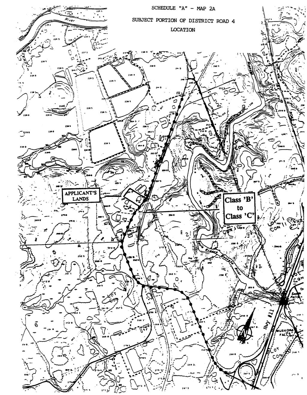
140
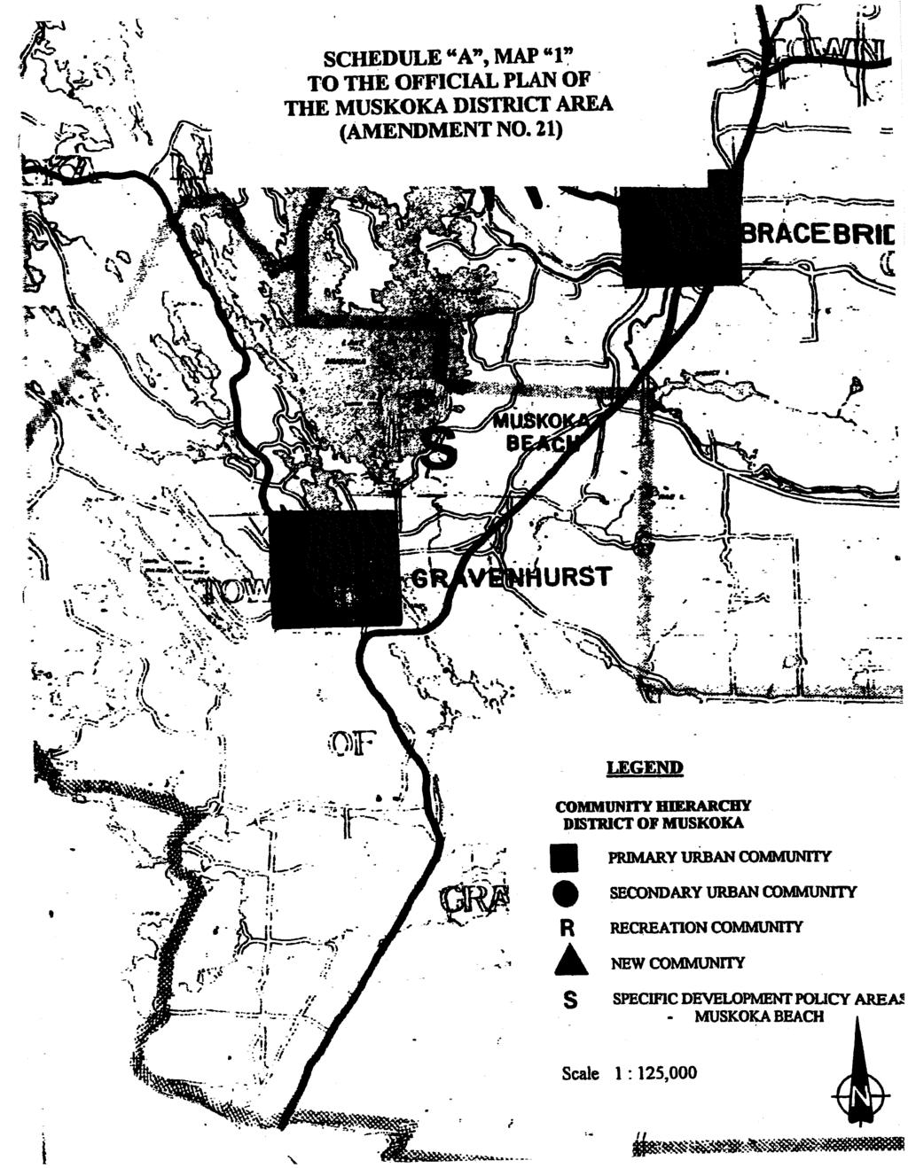
141
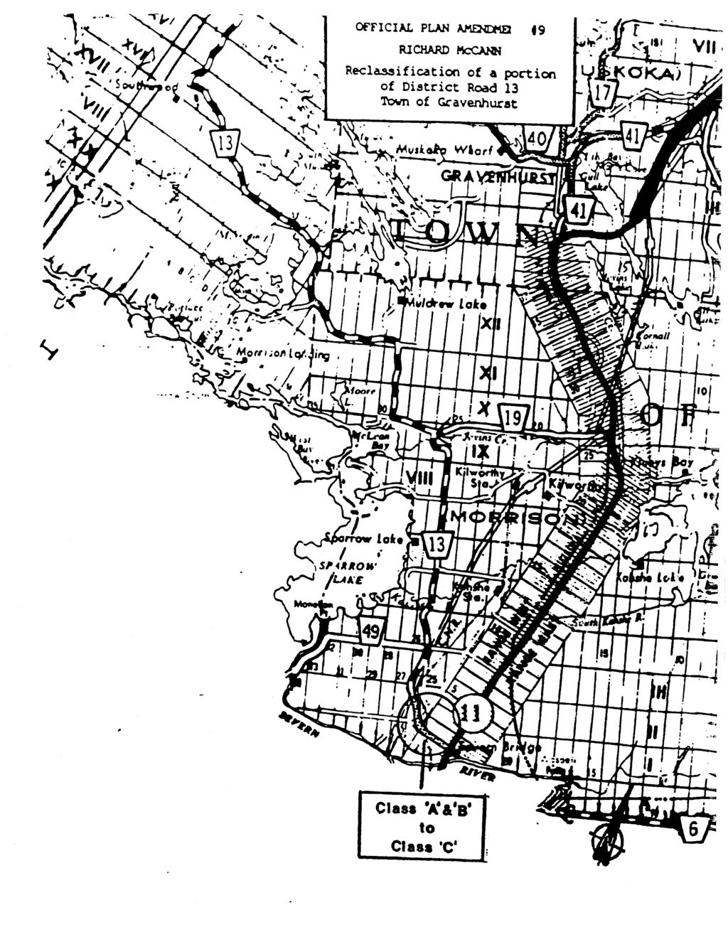
142
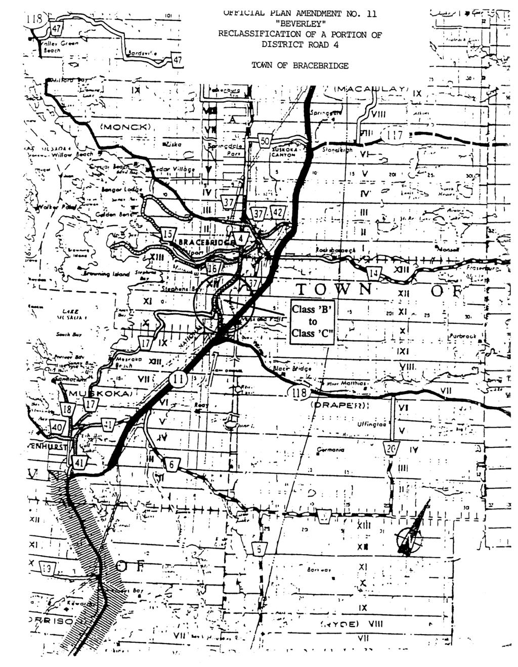
143
144
145
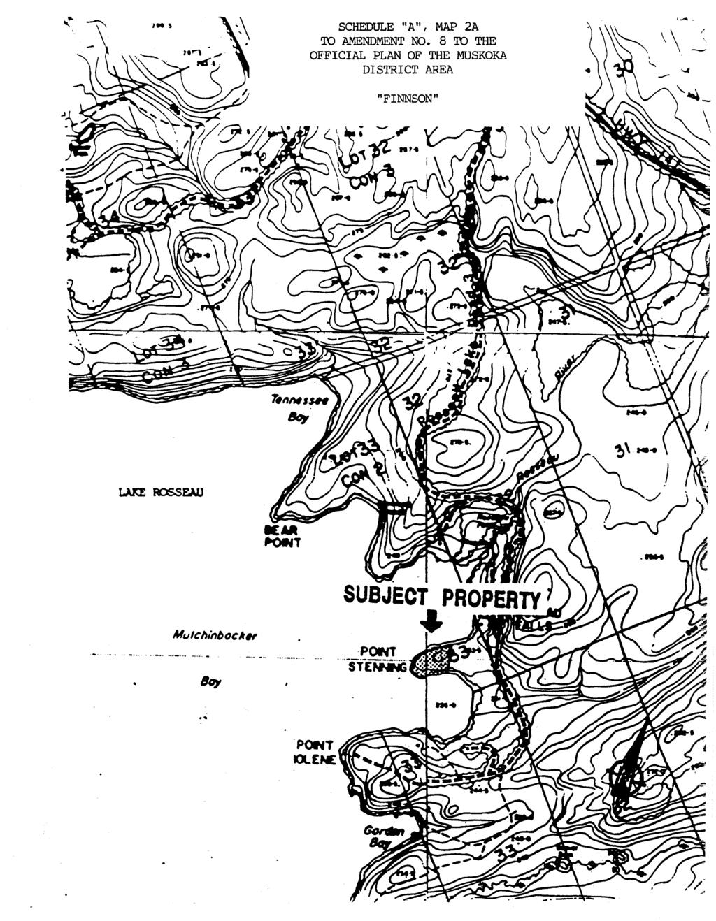
146