Agricultural Ditches, Waterways and Wetlands: Sorting It Out
|
|
|
- Ernest Gray
- 5 years ago
- Views:
Transcription


1 Agricultural Ditches, Waterways and Wetlands: Sorting It Out Eric Metz Planning & Policy Manager Aquatic Resource Management Clatsop SWCD Waterways Seminar March 16, 2018 Clatsop National Historical Park, Astoria Photo credit: Bruce Taylor
2 Environmental & Economic Factors Provide Background to Understand the Specific Issues I am going to: 1. Breakdown all the component parts of the puzzle 2. Explain how human settlement has influenced the landscape. 3. Explain why the natural functions of wetlands still matter in the modern world.

3 Youngs Bay is a High Functioning Watershed: What s That? A watershed is an area of land that drains rainwater or snow into one location such as a stream, lake or wetland. Valley floors have floodplains. Watersheds are important because the surface water features and stormwater runoff within a watershed ultimately drain to other bodies of water.

4 Flood Plain Dynamics WR in It s Channel (WR near Salem)

5 100-year Flood Plain, Same Location (1 percent chance of occurring in any given year)

6 WR Seasonal Flooding Sustains Crops, Stream Meaders and Wetlands

7 Willamette River (WR) Historical Stream Channels This LIDAR-derived (Light Detection and Ranging) digital elevation model delineates vivid historical channels, showing the dynamic movements the river. Monmouth and Independence at the top. Near the center, the Luckiamute River flows into the Willamette from the left, and the Santiam River flows in from the right.
8 Youngs Bay Watershed Fifth field watershed (standard size used) located in the northwest corner of the county. Youngs Bay is an arm of the Columbia River estuary. The Lewis & Clark River, Youngs River, Klaskanine River, and Wallooskee River flow into Youngs Bay, draining approximately 184 sq. mi. of land. The primary economic land use in the Youngs Bay watershed is timber harvest, with some agriculture in the lowlands (focus of this talk).
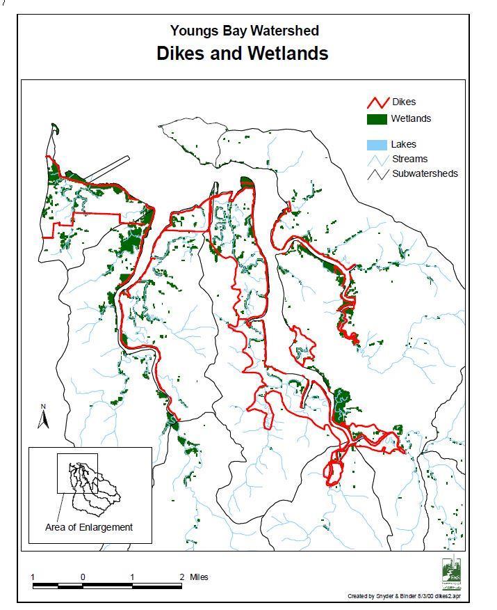
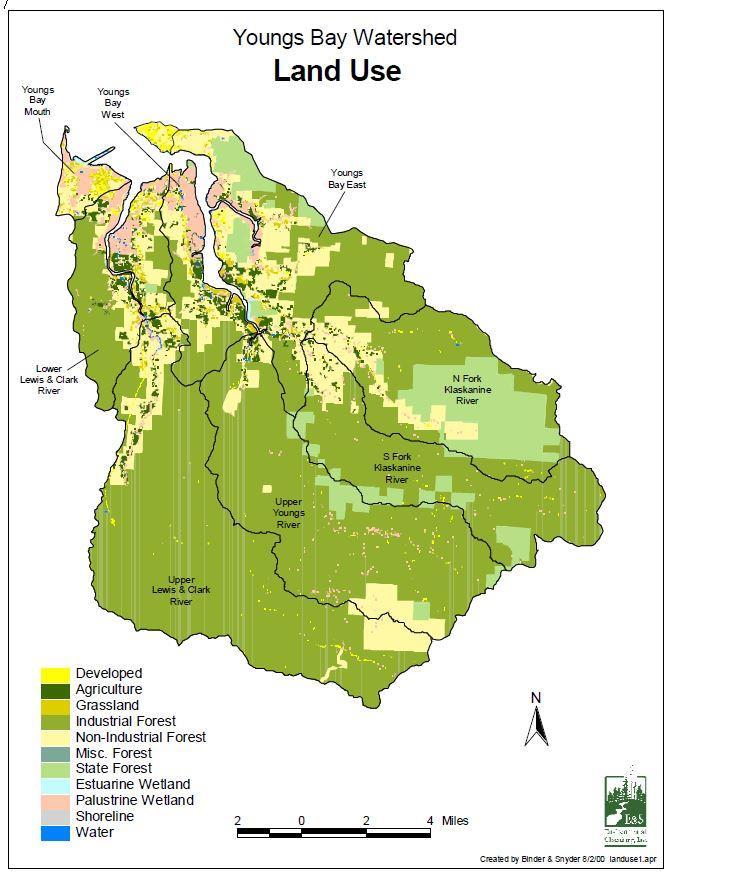
9 Dikes & Wetlands/Land Use

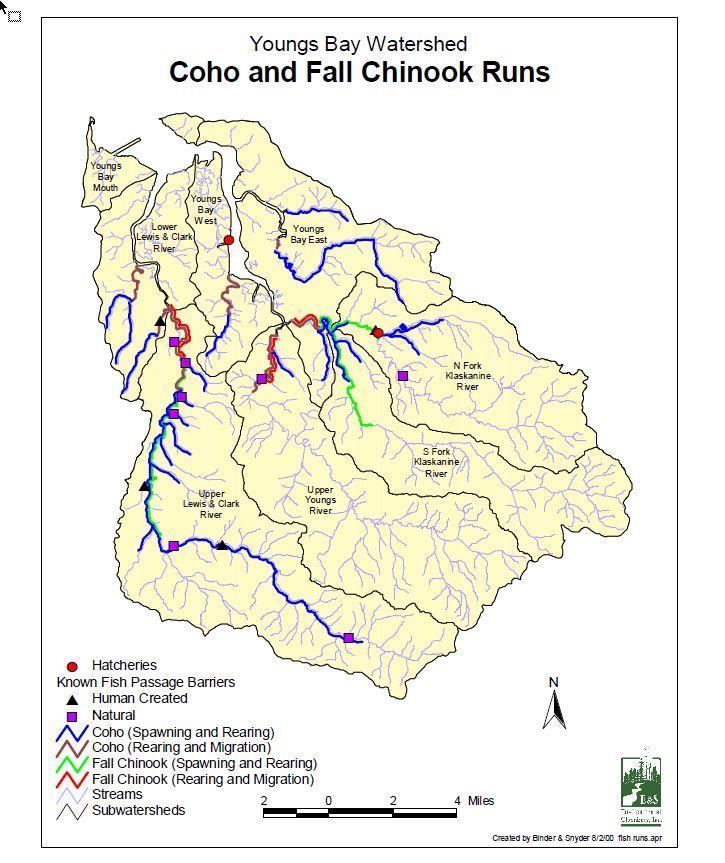
10 Youngs Bay Subwatersheds and Fish Runs
11 Essential Indigenous Anadromous Salmonid Habitat Designations

12 Wetlands means those areas that are inundated or saturated by surface or ground water at a frequency and duration sufficient to support, and that under normal circumstances do support, a prevalence of vegetation typically adapted for life in saturated soil conditions. What is a Wetland? (legal definition)

13 Wetlands Support the Watershed Water storage and delay Sediment retention Filter nitrogen, phosphorus and other nutrients. Transform, release into the atmosphere, and consume nutrients. Fish habitat support Aquatic habitat support Ecosystem support

14 Wetlands and Stream Interact Similar to streams and lakes, wetlands can receive ground-water inflow, recharge ground water, or do both. Those wetlands that occupy depressions in the land surface have interactions with ground water similar to lakes and streams. Hydrologically

15 This Short Video will help put the information all together. After the video we will provide specifics on Regulatory Issues Flooded Fields & Drainage Ditches of the Willamette Valley Habitat for Legacies for Native Fish & Wildlife Freshwaters Illustrated in collaboration with Oregon State University, Oregon Sea Grant Executive Producer Guillermo Giannico

.")
16 Removal-Fill, Mitigation and Wetland Conservation Laws The state has regulatory jurisdiction and enforcement authority over Waters of this State (all natural waterways, tidal and non-tidal bays, intermittent streams, constantly flowing streams, lakes, wetlands, the Pacific Ocean, and all other navigable and non-navigable bodies of water in this state). The US Army Corps has federal authority under the Clean Water Act.
 specialist: http://www.oregon.gov/dsl/w W/Pages/WWStaff.")
17 You Might Have Wetlands on Property You Either Own or Want to Purchase; How Can You Find Out? Contact a DSL permit coordinator or jurisdictional (wetland) specialist: W/Pages/WWStaff.aspx#map Fill out a Wetland Determination Request: W/Pages/WWforms.aspx
18 If You Have Wetlands on Property You Either Own or Want to Purchase; What Can You Do? Read our guide on identifying wetlands, wetland determinations and delineations and working with a wetland consultant: sl/ww/documents/dsl_ wetlands_fact_march_201 5_web.pdf Find out if the National Wetlands Inventory or Local Wetlands Inventory (contact: Jevra Brown) map show a wetland on the property: WW/Pages/Inventories.aspx nds/
 when mapped wetlands are present and they receive a complete application: https://forms.dsl.state.or. us/forms/wetlandusenot ice")
19 Contact Your Local Municipality Planning department staff must complete a Wetland Land Use Notification Form (contact: Jevra Brown) when mapped wetlands are present and they receive a complete application: us/forms/wetlandusenot ice
 The US Fish and Wildlife Service National Wetland Inventory (NWI) uses remote sensing and does not map certain types of")
20 But, Not All Wetlands are Mapped, Not all Cities and Counties Have Local Wetland Inventories; Why? Municipality-scale wetland mapping is technical and expensive ($100K/LWI) The US Fish and Wildlife Service National Wetland Inventory (NWI) uses remote sensing and does not map certain types of farmed wetlands Final DSL jurisdictional determinations require collection of data in the field and must follow a specific manual
 986-5266 Consult the Removal-Fill Guide: http://www.oregon.gov/dsl /WW/Documents/Removal_ Fill_Guide.")
21 What if You Suspect a Wetland May be On Your Property of Interest Contact DSL program-level staff (using the map) and if you can t get anyone within a day, call me: Eric Metz (503) Consult the Removal-Fill Guide: /WW/Documents/Removal_ Fill_Guide.pdf
22 What Does it Mean if Preliminary Screening Shows Jurisdictional Waters May be Present? Jurisdiction can only be confirmed by DSL Even if jurisdiction confirmed, your project may not impact the water Your project may be exempt and this can be confirmed using the NSP process DSL staff may help you figure out how to avoid or at least minimize impacts Even if an authorization is required, we have a range of ways to do that: o General Authorization (waiver); 30-days notification required o General Permit; 40-days o Individual Permit; 120-days o NSP No State Permit required
23 What Activities are Exempt? Converted Wetlands means agriculturally managed wetlands that, on or before June 30, 1989, were brought into commercial agricultural production by land alterations. Ditch means a manmade water conveyance channel. Channels that are manipulated streams are not considered ditches. Intermittent Stream means any stream which flows during a portion of every year and which provides spawning, rearing or foodproducing areas for food and game fish..
24 Exempt Farm Activities (NOTE: If not sure you qualify, contact DSL) Certain Activities on EFU Zoned Land: o Drainage/maintenance of farm/stock ponds o Maintenance of existing roads o Subsurface drainage by deep ripping, tiling or moling, on converted wetlands. Agricultural related activities on Essential Salmon Habitat (ESH) <50 cy Farming and ranching on converted Wetlands: o Plowing o Grazing o Seeding o Planting o Cultivating o Conventional crop rotation o Harvesting

25 Change in Point of Diversion Exempt if: Necessitated by a change in the location of the surface water; and Authorized by the Oregon Water Resources Department.

26 Agricultural Drainage Ditch Maintenance No Permit Required Exempt maintenance of agricultural drainage ditches under OAR (4) includes disposal of dredged material in a thin layer on converted wetlands, provided such disposal does not change wetland to upland. For the purposes of this exemption, ditch means a manmade water conveyance channel. Channels that are manipulated streams are not considered ditches.

27 Regulated Agricultural Drainage Channels (Manipulated Streams) Channels that have: Food or game fish Free and open connection to other waters of State o A free and open connection means a connection by any means, including but not limited to culverts that allow the interchange of surface flow o At bankfull stage or ordinary high water
28 Maintenance/Reconstruction of Water Control Structures Conditionally Exempt Culverts Dikes Dams Levees Groins Riprap Tidegates Drainage ditches Irrigation ditches Tile drain systems Conditions: The project meets the definition of maintenance; or The project meets the definition of reconstruction; The structure was serviceable within the past five years; and The maintenance or reconstruction would not significantly adversely affect wetlands or other waters
29 We Are Always Available to Provide Assistance and Answer Questions Call Request a site visit Request a pre-application meeting Request a presentation that is customized for your group/region (requested by Mary Olson)
30 Acknowledgements Wikipedia, Oregon History Project, Microsoft and other web sources for photographs and illustrations Youngs Bay Watershed Assessment Department of Geology and Mineral Industries (DOGAMI) for LIDAR images Dr. Guillermo R. Giannico for bringing the video he produced to our attention and for his research in the Willamette Valley

31 Thanks for your Attention!