For inspection purposes only.
|
|
|
- Shavonne Hoover
- 5 years ago
- Views:
Transcription
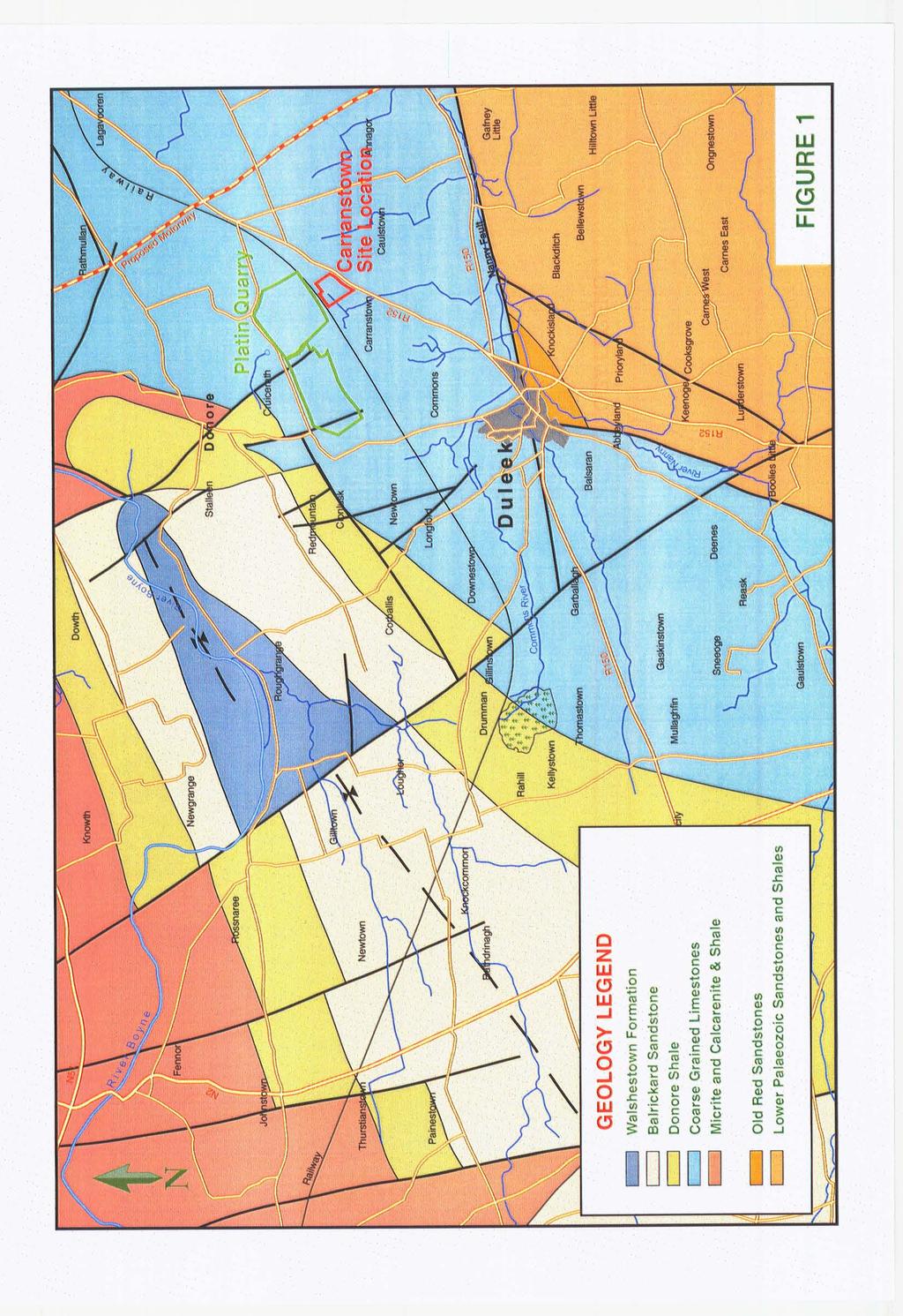
1 6 INDAVER IRELAND - Carranstown Duleek Statement of Evidence Eur.Geol Teri Hayes B.Sc M.Sc P.Geo, 1.O Experience 1.1 My name is Teri Hayes. I am a Senior Hydrogeologist and Director of White Young Green Ireland. I qualified with an Honours degree (1990) in Geology from Trinity College Dublin and, a Masters degree (1991) in Hydrogeology from Birmingham University. I have since gained professional qualifications as a hydrogeologist within the Institute of Geologists of Ireland and the European Association of Geologists. I have thirteen years of experience in the area of aquifer assessment and management. During that time I have undertaken a wide range of hydrogeology related projects for both private and public bodies. 1.2 My office carried out soil and groundwater studies on the Carronstown development site. The baseline soil and groundwater conditions determined during these investigations are outlined in Section 8 of the EIS. 2 Geology and Soil Type 2.1 Summarv of Geoloov at the Site Grey limestone which was weathered at the surface was proven by borehole drilling on the site. This limestone is typical of the Lower Carboniferous shallow water limestones. These are typically pale thick-bedded with minor shales, possibly dolmitised, with palaeokarstic features. (Geological Survey of Ireland (GSI) Sheet 16 and Meath Groundwater Protection Scheme). Figure 1 presents the local geology as described by the GSI. These Carboniferous limestones (the Platin outcrop) between the older Lower Palaeozoic sandstones and shales of the Longford Down Massif to the North and the block of similarly aged meta -sedimentary rocks that extend between Julianstown and Balbriggan to the south. The Platin outlier is fault bounded and the deposit is known to be at least 300 metres thick. 2.2 Aquifer Classification Using the Geological Survey of Ireland Classification (GSI) system, bedrock is described as Regionally Important, Locally Important or Poor Aquifers based on the value of the resource and the hydrogeological characteristics. The Platin limestones had been designated as Regionally important fissured limestones (Rf). In 2004 this aquifer was reclassified as Regionally important karstified limestones (Rk). THICarranstownIMar 2005 Page 1 EPA Export :15:23:17
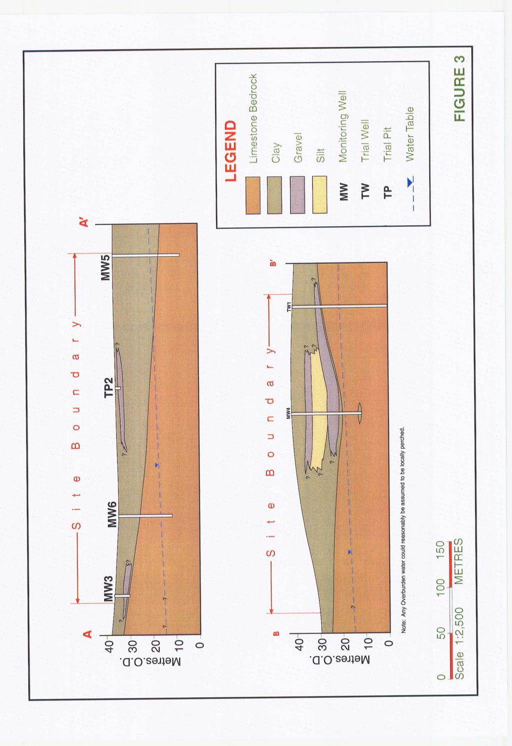
2 2.3 Soil Tvpe & Thickness The overburden consists predominantly of brown silty boulder clays with some lenses of sands and gravels. Based on site drilling and trial pitting, the thickness of soil ranged from 5 metres towards the west of the site to greater than 20 metres towards the centre of the site. Figure.3 present cross sections showing the geology beneath the site. 3 Aquifer Vulnerability and Resource Protection 3.1. Assessment of Aquifer Vulnerability The GSI/EPA/DOELG Groundwater Protection Scheme Classification (see table below) ranks the site as having moderate (M) vulnerability due to the thickness and type of overburden cover present on the site. Table 1: Vulnerability Mapping Guidelines Hydrogeological Requirements Low Notes: i)n/a =not applicable 1 >lo.om 1 N/A 1 N/A ii) Precise permeability values cannot be given at present iii) Release point of contaminants is assumed to be 1-2 m below ground surface Source: Groundwater Protection Schemes - DOELG/EPA/GSI The Inspectors report stated that he considered that the aquifer vulnerability should be rated as having a high vulnerability. This would require that the overburden thickness was less than 5 metres or that the overburden type was a sandy till rather than a clayey till. However, based on our assessment of the soil thickness and type at the site, I would consider that the site should be rated as having a moderate vulnerability as stated in the EIS. Figure 2 presents the location of the soil borings and trial pits across the site together with lines of cross section. The lines of cross section are presented in Figure 3 and show schematically that the shallow geology across the site comprises boulder clays for the most part with some discontinuous lenses of silts and gravels. In addition, percolation testing was undertaken at the site and extremely low percolation rates were measured due to the presence of these clays. THICarranstownlMar 2005 Page 2 EPA Export :15:23:17
3 3.2 Assessment of Resource Protection Zonation As the bedrock is considered to be Regionally important, and the soil cover varies from 5 metre in thickness to at least 20 metres in thickness, the site is assigned a rating of Regionally important-moderate (Rk/M) under the GSI classification system for designating resource protection zones. Response levels have been developed for a three polluting activities (septic tanks, landspreading and landfills using this matrix of resource protection zones. Based on the risk involved for each of these potentially polluting activities, they are either acceptable, acceptable subject to conditions, not acceptable with some exceptions or not acceptable. There is no response table developed for waste to energy plants. 4 Groundwater Flow regime The facility is to be located in an area where the groundwater regime has already been impacted by the dewatering associated by the nearby Platin quarry. The site is within the cone of influence of the quarry dewatering. A trial well was drilled and tested at the site and the test results confirmed that a sustainable yield of 470 cubic metres per day is possible. Any water abstracted at the Carranstown site will correspondingly reduce the amount being abstracted from the quarry. Therefore the volume of groundwater to be abstracted on the site will not materially alter the current groundwater flow regime. 5 Soil &Water Quality Representative soil and water samples were collected from five boreholes and seven trial pits across the site. Samples were analysed for priority pollutants including hydrocarbon indicators, (PRO, DROs mineral oils and BTEX compounds), Volatile Organic Compounds, Polycyclic Aromatic Hydrocarbons (PAHs), Metals, Total phenols, Pesticides and Polychlorinated Biphenyls (PCBs). The results of this investigation showed that there is no significant soil or groundwater contamination at the site. However some traces of metals and inorganic contaminants were identified. The levels identified would commonly reflect agricultural activity within the area. 6 Mitigation There is no direct discharge to groundwater from the proposed facility. Mitigation measures to be used during the construction and operation of the development are discussed in sections 8.3, 8.4, 9.3 and 9.4 of the EIS. These include the storage of potentially polluting substances in suitably bunded areas, the containment of sewage for off-site disposal during the construction phase, the management of run-off from hardstanding areas, roads and car parks through oil interceptors and, the provision of silt traps to prevent the discharge of silty waters into the local drainage network during site construction. THKarranstownlMar 2005 Page 3
4 As described in MS Lydens evidence, the surface water will only be discharged to the existing stream only in exceptionally wet weather, 1 in 20 year rain storm. In this scenario, the discharged water will be from the roof of the main building or following treatment in an oil interceptor. As such it will not impact on the quality of water in the underlying aquifer. Based on the implementation of mitigation measures during the operation of the facility it is not expected that there should be any detrimental effect on the underlying soil and groundwater. In addition, regular monitoring of groundwater will take place, which will detect any changes in groundwater quality during the operation of the facility. References: Geological Survey of Ireland (1994) Geoloov of Meath GSIIEPAIDOELG (1999) Groundwater Protection Schemes Meath Groundwater protection scheme (1996)
5 Response to Objections Obj 5: No Incineration Alliance - I The site is located on an RfH (high/y vulnerable aquifer) adjacent to an RfE(extremeiy vulnerable aquifer). The site gets an R4 rating which indicates the increased likelihood of water contamination and increased consequence. The rating indicates that the site is not acceptable for any such development. The same rating R4 highly vulnerable applies to septic tank systems. The site is therefore inappropriate for such a development. II Response: Based on our site investigations the vulnerability of the site was found to be moderate (see 3.1 above). Using the GSVEPAIDOELG system this would result in a classification of RkM for the site. The GSIIEPAIDOELG have developed response levels for three potentially polluting activities (septic tanks, landspreading and landfills) using this matrix of resource protection zones. Based on the risk involved for each of these potentially polluting activities, they are either acceptable, acceptable subject to conditions, not acceptable with some exceptions or not acceptable. There is no response table developed for waste to energy plants. Industries and towns such as Drogheda are commonly located on regionally important aquifers. The objector refers to an R4 rating inaccurately. The table from which this R4 rating is abstracted is just a table used by the GSVEPNDOELG to illustrate the approach used in developing response levels. The responses in the matrix will obviously change depending on the polluting potential of the activity. For example the response for on site wastewater systems for single houses for an RkM aquifer is RI (acceptable subject to normal good practice) while for a landfill it is R4 (not acceptable) Obj IO: Counciiors for the East Meath Area The site at Carranstown is classified as a regionally important aquifer and according to the GSI map of the area is high to extreme vulnerability with regard to pollutant risk. The EPAs Inspector in his report (page 9) agrees with this classification. The EIS document for lndavers Carranstown incinerator contained a tabulated page of WHO guidelines for choosing a site for a potentially polluting plant/project. The guidelines recommended the rejection of areas of regional/y important aquifers and areas of major aquifer recharge. These guidelines quoted by lndaver have been completely ignored. Response: Based on site investigations the site is a regionally important aquifer with moderate vulnerability. The overburden thickness varies from 5 metres to 20 metres across the site. Mitigation measures to be used during the construction and operation of the development are discussed in sections 8.3, 8.4, 9.3 and 9.4 of the EIS. These include the storage of potentially polluting substances in suitably bunded areas, the containment of sewage for off-site disposal during the construction phase, the management of run-off from hardstanding areas, roads and car THICarranstownlMar 2005 Page 5
6 parks through oil interceptors and, the provision of silt traps to prevent the discharge of silty waters into the local drainage network during site construction. Based on the implementation of mitigation measures during the operation of the facility it is not expected that there should be any detrimental effect on the underlying soil and groundwater. In addition, regular monitoring of groundwater will take place, which will detect any changes in groundwater quality during the operation of the facility. Page
7
8 EPA Export :15:23:19
9 EPA Export :15:23:19