Hydrogeologic Evaluation of a Combined GSI and Deep UIC Well Infiltration System for Flow Control Venema NDS Project, Seattle, Washington
|
|
|
- Darcy McKinney
- 5 years ago
- Views:
Transcription

1 Hydrogeologic Evaluation of a Combined GSI and Deep UIC Well Infiltration System for Flow Control Venema NDS Project, Seattle, Washington


2 Seattle Public Utilities Venema Creek Natural Drainage System Presented by: Curtis J. Koger, L.G., L.E.G. L.Hg.

3 Co- Authors Susan Beckham, P.E. AESI Jeff Massie, P.E. SPU Masako Lo, P.E. SPU Jenny Saltonstall, L.G., L.Hg. AESI Kathy Gwylim, P.E. SvR Additional Contributions Claire Gibson, P.E. SPU Tracy Tackett, P.E. SPU Bridget August, L.G. - AESI Lara Koger - AESI Many others at SPU, SvR and AESI

4 Presentation Outline Project Background Geologic and Hydrogeologic Setting Subsurface Exploration UIC Well Construction Flow Testing Potential Impacts Analysis Results and Conclusions


5 Project Background Need for Alternative Stormwater Systems Problems with Existing Stormwater System Constructed without integrated flow control and WQ treatment facilities Degradation of Venema Creek Basin Solution: Retrofit using GSI methods


6 Venema NDS Project Area - Pipers Creek Watershed

7 Project Background Goals (General) Filter, Attenuate, and Divert Stormwater Infiltrate Stormwater Across Multiple Watersheds Return Watersheds to Pre-development Hydrology


8 Project Background Venema NDS Goals Improved Volume and Peak Flow Hydrology to Venema Creek Improved Water Quality Minimize Biological, Water Quality and Flow Impacts to Venema Creek Install Formal Stormwater Conveyance System Provide Street Improvements


9 Geology/Hydrogeology Key Considerations Geologic Units Depth to Groundwater Fate of Infiltrated Stormwater


10 Reference: D. Molenaar, 1987


11 Typical Puget Sound Geology Source:

12 Geologic and Hydrogeologic Setting

13 Storm Water Flow on Till Site - Shallow Low Permeability Unit

14 Subsurface Exploration Goals: Characterize Site Geology and Hydrogeology Identify Receptor Zone for deep UIC Wells Characterize Aquifer Provide Basis for Impacts Analysis Program: Drill 1 Pumping Well and 2 Monitoring Wells Drill 2 Deep UIC Wells Grain Size Analysis Aquifer Pumping and UIC Flow Tests

15 Geologic and Hydrogeologic Setting

16 Subsurface Exploration Key Findings 30 - Very Low K Vashon Lodgement Till (Qvt) Interbedded Vashon advance outwash (Qva) encountered beneath till Unsaturated zone ranges from 30 to 200 thick Provides deep infiltration target Regional Qva Aquifer encountered near elev. 310 Qva Aquifer discharges at springs into Venema Creek west of project area (elev. 287 )

17 Geologic and Hydrogeologic Setting

18
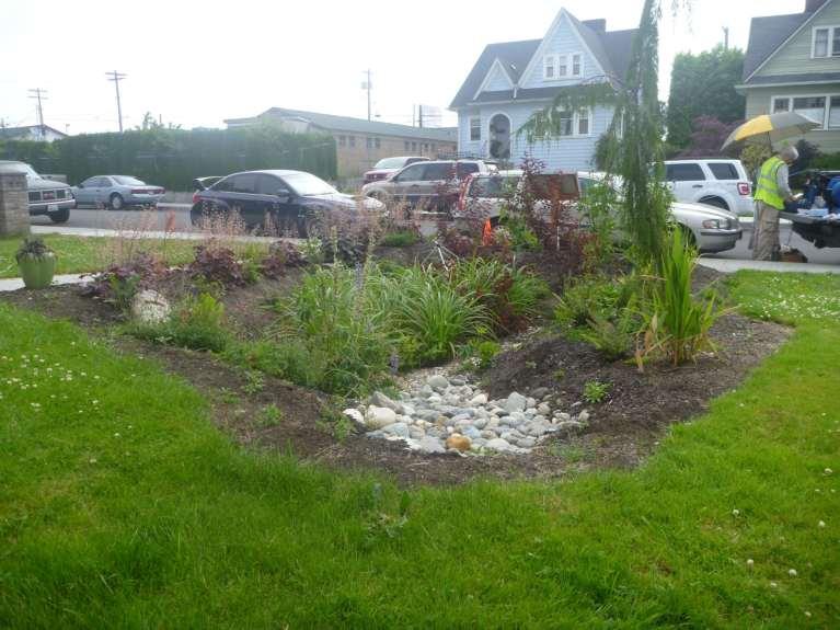
19 Bioretention Facility

20 Bioretention with Deep UIC Well

21 UIC Well Construction and Testing Construction: 6-inch Air Rotary Well 30 of 10 slot Well Screen Testing: 8 hour flow period Determine design flow rate


22 UIC Well Construction Method Screen Assembly Air Rotary Drill Bit


23 UIC Well Construction Method Development Water Discharge Jetting Tool

24 In-situ UIC Well Screen Zone Well Screen Native Formation

25 Grain Size Analysis - Mechanical

26 Grain Size Analysis Mechanical - Average

27 Aquifer Characterization Aquifer Testing Stepped-Rate Constant-Rate Aquifer Parameters Hydraulic Conductivity Transmissivity

28 Stepped-Pump Rate Aquifer Testing
29 Constant-Pump Rate Aquifer Testing Plot of Drawdown at Observation Well MW-2, r = 62 T = 2100 ft 2 per day b = 90 feet K H = 23 feet/day Moench 1997 Solution AQTESOLV computer software


30 UIC Well Testing Method Water discharging through flow meter into the UIC well Flow Meter Assembly and Water Level Meter

31 UIC-1 Testing

32 UIC-2 Testing

33 Potential Impacts Water Quality Infiltrate treated stormwater Meets Ecology s Enhanced criteria Slope Stability Mounding/slope stability analysis Setbacks from slopes
34 City of Seattle Untreated Residential Stormwater Quality Data Contaminant Average Stormwater Quality, Residential Site R1, City of Seattle (1) Ground Water MCL WAC Total Cadmium (µg/l) * Total Copper (µg/l) ,000* Total Lead (µg/l) * Total Zinc (µg/l) ,000* Nitrate (mg/l) Chloride (mg/l) MCL Maximum contaminant level. * MCLs listed in WAC for Copper, Lead, and Zinc MCL are total metals. µg/l micrograms per liter. mg/l milligrams per liter. (1) City of Seattle, March 20, 2012, Attachment C, City of Seattle 2011 NPDES Phase I Municipal Stormwater Permit Stormwater Monitoring Report.

35 Results and Conclusions Significant volumes of stormwater could be conveyed to the subsurface via deep UIC wells. Deep infiltration has the potential to reduce erosive surface water discharge into Venema Creek, improve water quality and increase base flows into the stream system.

36 Questions


37 Venema Creek Natural Drainage System