Tuesday, February 25, 2014 Western Canal Water District Office Nelson, CA. Stakeholder Meeting Notes
|
|
|
- Nigel Barrett
- 5 years ago
- Views:
Transcription
 - Feather RFMP Sutter")
1 Stakeholder Meeting Notes Tuesday, February 25, 2014 Western Canal Water District Office Nelson, CA Meeting Attendees Tom Engler Mike Inamine Mike Mirmazaheri David Miller Kim Floyd Craig Myers Carl Hoff Gary Lindberg Ted Deen Dennis Lindberg Paul Sankey Stacy Gore Larry Hansen Ryan Schohr Audrey Stephens Greg Stephens Gary Stone Sean Earley Attachments MBK Engineers (MBK) - Feather RFMP Sutter Butte Flood Control Agency (SBFCA) - Feather RFMP GEI Feather RFMP GEI Feather RFMP Feather RFMP Western Canal Water Butte County Rice Growers Association (BUCRA) (ICF) LaMalfa Farms Attachment 1: Sign In Sheet Attachment 2: Feather River RFMP Fact Sheet Attachment 3: Cherokee Canal Write-Ups from 10/4/2013 DRAFT Feather River RFMP Meeting Objectives Tom Engler explained the purpose of the meeting was to inform the development of the Feather River Regional Flood Management Plan (FRRFMP) by having an open and candid discussion on the local perspective of flood control issues and facilities, including Cherokee Canal. Summary of Key Discussions The following are summaries of the key points of the discussion for consideration in the RFMP:
2 1. The key flood control issue for the Cherokee Canal is a lack of maintenance resulting in sediment aggradation and overgrowth of vegetation which greatly impedes the conveyance capacity of the channel. s emphasized that vegetation was a bigger problem than sediment. 2. Tom Engler described that, to his understanding, the Canal was designed for approximately 50-year flood protection, only constructed for 25-year protection, but currently can only convey somewhat less than a 25-year flood event. s stated that when channels were regularly cleaned and maintained there were only occasional minor flood issues. The only event that caused flood damage was in Mr. Schohr commented that the Feather RFMP, Section contradicts itself by supporting clearing of the channel and recommending that additional habitat be implemented in the channel. RFMP representatives committed to either removal or substantial re-write of paragraph 3 of the subject section of the report. 4. s arduously expressed their concern over additional habitat being placed or created in the channel and the channel not being cleaned. Several key points from this discussion are: a. The Cherokee Canal is approximately 1,000 total acres of leveed channel that protects approximately 35,000 acres of agriculture lands, nearly all of which is rice. The main endangered species in the area is GGS for which the rice is the habitat. It is unclear as to why the 1,000 acres of habitat in the channel is more important than the 35,000 acres of habitat outside of the channel. Clearing the channel would protect the 35,000 acres. b. s expressed frustration that public safety is being trumped by habitat, especially given the fact that this area was only marginal habitat prior to rice production which began in the 1950s. Besides the extensive infrastructure to support agriculture, there are (100 s?) domestic potable water wells, a sewer treatment facility, and numerous homes and structures protected by the levees on the Cherokee Canal. Finally, the water quality impacts from a flood in this area could be devastating to much of the habitat in the area and that downstream. c. Prior to rice production in the area, there was very little or no GGS habitat. With the current agricultural infrastructure, GGS is flourishing in the area (there are studies that support this). The landowners would like credit for the habitat they have created and continue to maintain at their own cost instead of constantly being asked to provide additional habitat that did not previously exist in the area. d. Creation of habitat creates significant issues that are not currently being addressed in the planning process including: economic impacts of land conversion; long term maintenance costs associated with restoration areas; eventual flood control impacts of overgrown habitat areas; and impacts to adjacent property owners who may have to mitigate for habitat that encroaches into their operations. Feather River RFMP Stakeholder Meeting Notes February 25, 2014 Page 2 of 3
3 Key Recommendations from Stakeholders The following is a prioritized list of actions that could be supported by the landowners: 1. Clean the Channel of existing overgrowth of vegetation and remove accumulated sediment to restore the channel capacity. s acknowledged that not every tree needs to be removed. Additionally, it was suggested that a plan could be developed to stage removal to allow portions to remain, for example: clear one third of the channel every five years or clear the center and leave some along the edges, etc. This option will need to have a longterm and reliable funding source to ensure deferred maintenance does not result in the same existing situation occurring in the future. 2. Construct upstream sediment traps and/or detention basin(s). These basin(s) could be located where the Debris Commission dams were previously. Design would accommodate the ability to regularly remove sediment from the basin(s), attenuate the peak flow to reduce stress on the downstream levees, and allow for habitat around these basin(s). This option would have to include the consideration of the duration of inundation to ensure no long-term impacts from seepage to adjacent orchards. 3. Construct weirs and implement controlled breaching of the left bank levee to protect critical infrastructure and the Richvale Community on the west/north side of the Canal during extreme events. It is believed the few protected structures could be flood proofed. It was acknowledged and agreed that affected property owners would need to have the opportunity to weigh in on this approach. 4. Produce accurate FEMA maps of the area. The area is currently an A zone with no identified flood elevations. Accurate maps would provide the necessary information for flood proofing or re-building infrastructure. 5. Develop a long-term O&M plan for the canal and any associated mitigation or restoration in the area. This plan would need to be supported with adequate funding, include plans to protect adjacent property owners from any potential impacts of mitigation or restoration, and provide long-term permits for Canal maintenance. Follow-Up Items Future meetings will be scheduled with property owners, DWR Basin Wide Feasibility Study representatives, DWR Maintenance Office, Mid and Upper Sacramento River Regional Planning team, and Environmental Stakeholders to continue to flesh out solutions and actions. The Feather RFMP will be revised to incorporate the suggestions and position of the affected property owners of the area. Feather River RFMP Stakeholder Meeting Notes February 25, 2014 Page 3 of 3


4 -c3 7-, 3 -p I: - 5- I, 0 JI C IF tr t

5 Call to Action: Identify Flood Management Priorities for Your Region! Public agencies in your area are partnering to identify and address regional flood management challenges and opportunities within the Feather River basin. The planning area covers Yuba County and portions of Sutter, Butte and Placer Counties (see map on reverse). The Plan will be integrated into larger studies being conducted by the state and the 2017 update to the Central Valley Flood Protection Plan. Projects and priorities outlined in the plan will be eligible for future state funding. The effort is being fully funded by the California Department of Water Resources with Proposition 1E bond funds approved by voters in With input from their communities, partnering agencies will develop a Regional Flood Management Plan by mid-2014 that defines the long-term vision for flood risk reduction. The plan will include: description of the current flood management conditions opportunities for improving flood management while achieving multiple objectives (flood protection, agricultural conservation and habitat restoration, for example) needed projects based upon priority preliminary financing plans (local, state and federal) Input is needed from property owners (residents and businesses), environmental interests, tribal organizations, business and civic groups, and local government agencies. The planning process, which is an opportunity to integrate local expertise into statewide studies and the 2017 update to the Central Valley Flood Protection Plan, is open to all interested individuals. Plan Development Timeline Kickoff Meeting June 5, 2013 Workshop: Draft Plan Review December 2013 Workshop: Draft Final Plan Review April 2014 Don t miss your chance to shape this important plan. For more information and to register for meeting notifications and opportunities to have input on planning documents: kim@floydcommunications.com The Feather Regional Flood Management Plan is a collaboration of the following agencies on behalf of the communities they serve: Yuba County Water Agency Marysville Levee Commission Three Rivers Levee Improvement Authority Sutter Butte Flood Control Agency

6 Feather River Regional Flood Management Plan Regional Plan Boundaries


7 LEVEE IMPROVEMENT AUTHORITY DRAFT October 4, 2013 Feather River Region Regional Flood Management Plan Funded by the California Department of Water Resources
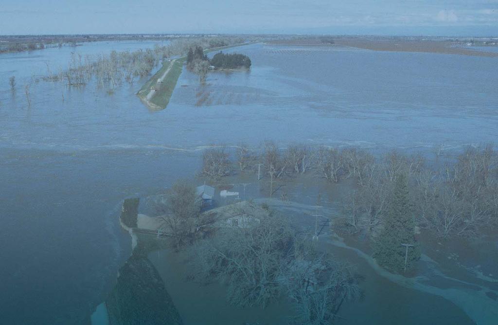
8 RD 1001 maintains the Bear River left-bank levee, from high ground to the Feather River confluence, which protects Nicolaus, East Nicolaus, and Rio Oso, as well as the agricultural lands and infrastructure within RD 1001 boundaries. Wildlife: There are numerous species of mammals and birds, including migratory birds in this area, including the farm lands adjacent to the river corridor Cherokee Canal The Cherokee Canal is a component of the SPFC that diverts excess floodwater originating in the foothills northeast of the Thermalito Afterbay, including the site of the Cherokee hydraulic mine, which continues to release sediments during high flow periods. The facilities consist of levees along Cherokee Canal, the lower reaches of Cottonwood Creek and Gold Run Creek, and irrigation and drainage structures from Butte Basin to high ground. The facilities reduce flood risk to adjacent communities, agricultural lands, area transportation facilities, and irrigation canals. The facilities are maintained by DWR Maintenance Area 13. The right-bank levee along Dry Creek and Gold Run Creek extends about 5.2 miles from high ground to the confluence with Cottonwood Creek. The left-bank levee extends about 3.5 miles from high ground to the confluence with Cottonwood Creek. The design capacity of this reach is about 8,500 cfs with 3 feet of freeboard, based on the O&M manual. The lower reach of Cottonwood Creek has a design capacity of about 3,500 cfs. Right- and leftbank levees, each about 1.3 miles long, extend from high ground to the connection with the Cherokee Canal levees. Downstream from Cottonwood Creek, the Cherokee Canal has a design capacity varying from 11,500 cfs to 12,500 cfs, based on the O&M manual. The right-bank levee extends about 14 miles. The left-bank levee is about 17 miles long. About midway along this reach, to allow flow to enter from the east, the left-bank levee is broken into two parallel segments for approximately 1.5 miles (DWR, 2010). Sedimentation: The Cherokee canal was built by the USACE in 1960 to provide increased flood protection to the communities, farmlands, and infrastructures. In the following years after the construction, sediments from historic hydraulic mining began to accumulate within the canal. As a result, flood flows reached or exceeded flood stage on numerous occasions in the 1960s. Investigations by DWR concluded that the section between the Western Canal and the Richvale Highway Bridge is constricted enough to not safely allow the flows to pass the channel design flow capacity of 11,500 cfs. Maintenance: Sediment deposition is a major maintenance concern for much of the length of Cherokee Canal, due to the continued discharge of sediment from gravel pits and the Cherokee Hydraulic Mine on Dry Creek and Gold Run Creek. DWR has been removing large quantities of sediment accumulation from the canal as part of its ongoing maintenance activities and is continuing to refine its maintenance practices in order to restore and maintain channel capacity while retaining the wildlife habitat values of the channel. Vegetation: Volunteer riparian vegetation grows quickly on the sediment. The combination of mineral soil, suitable topography, and inflows of water from rainfalls and agricultural return has created ideal conditions for germination and growth of riparian vegetation. Typical riparian species within the canal are cottonwoods, willows, and alders making it difficult and expensive Feather River Regional Flood Management Plan October Administrative Draft
9 to maintain channel capacity. The DWR maintenance program focuses on preserving the valuable habitat in the Cherokee Canal Sutter Bypass, including Wadsworth Canal The Sutter Bypass was constructed to create a bypass flood channel for the Sacramento River system as a component of the State Plan of Flood Control. The Sutter Bypass conveys overflow flood waters in a southeasterly direction away from the Sacramento River at a capacity substantially greater than the Sacramento River. As such, it is an integral part of the existing integrated flood management system, which helps protect the small agricultural legacy communities of Colusa, Meridian, Grimes, Robins, Kirkville, and Knights Landing. The Sutter Bypass originates southwest of the Sutter Buttes, downstream of Butte Slough, and terminates at Fremont Weir, 35 miles downstream. It receives flood flows from the Butte Basin overflow area near Ord, from Moulton Weir, Colusa Weir, Tisdale Weir, Butte Creek, Cherokee Canal, local drainage from the western portion of the Sutter Buttes, local drainage from the eastern portion of the Sutter Buttes via Wadsworth Canal, and local drainage from the Sutter Basin via pump stations. The Sutter Bypass is a wide flat channel dropping less than 30 feet over a distance of over 35 miles and varying in width from approximately 4,000 feet in its upper reaches to 6,200 feet along its furthest downstream reach between Nelson and Sacramento sloughs where the bypass parallels the Feather River channel. The West Borrow and East Borrow canals were excavated parallel to the bypass levees to supply the borrow materials needed to construct the bypass channel levees. Both canals convey water year round. Small weirs with fish bypass facilities control the water levels in the canals to facilitate irrigation of the agricultural lands within the bypass. USACE design flows for the Sutter Bypass increase in the downstream direction, from 150,000 cfs at its upstream starting point at Butte Slough near State Route 20 to the Wadsworth Canal, to 155,000 cfs between the Wadsworth Canal and the Tisdale Weir. Further downstream the Sutter Bypass was designed to pass 180,000 cfs between Tisdale Weir and Nelson Slough and then 380,000 between Nelson Slough and the confluence with the Sacramento River at Verona. Sedimentation and Vegetation: Given its importance in conveying massive flood flows for the Sacramento River Flood Control Project while protecting adjacent agricultural lands and communities, a significant concern is the incremental loss of channel capacity over time due to sediment accumulation and the growth of woody vegetation in portions of the bypass. While sediment is occasionally removed by DWR from the bypass channels of Moulton Weir, Colusa Weir, and Tisdale Weir, the Sutter Bypass itself may be losing depth and capacity over time due to sediment (see Figure 4-16). Feather River Regional Flood Management Plan October Administrative Draft
10 5 Solution Strategies and Management Actions 5.1 Planning Context: Central Valley Flood Protection Plan, State System-wide Investment Approach The 2012 Central Valley Flood Protection Plan recommends a State System-wide Investment Approach (SSIA), which includes a combination of major physical and operational elements which will most cost effectively achieve its goals and objectives. The regional solution strategies and management actions described in this chapter are consistent with the types of actions included in the SSIA. They include improvements to the structures and operations of levees, channels, reservoirs, fisheries and wildlife habitat (especially associated with productive agricultural lands), generally described at a greater level of specificity and detail than provided in the CVFPP. The CVFPP includes system-wide and regional improvements as summarized in Table 3-2 of the CVFPP. Of the physical and operational elements described in that table, the following subset could directly or indirectly affect the Feather River region: New Bypass Construction and Existing Bypass Expansion o Sutter Bypass expansion o Yolo Bypass expansion o Sacramento Bypass Expansion FCO and FBO o Oroville Reservoir o New Bullards Bar Reservoir Flood Structure Improvements o Butte Basin small weir structures o Upgrade and modification of Colusa and Tisdale weirs o Sacramento Weir widening and automation o Low level outlets at New Bullards Bar Dam o Fremont Weir widening and improvement o Other pumping plants and small weirs o Sacramento system sediment remediation downstream from weirs Urban Improvements o Target 200-year level of protection for selected projects developed by local agencies, State, federal partners Small Communities Improvements o Target 100-year level of protection for small communities protected by the SPFC Rural Agricultural Improvements o Site-specific rural-agricultural improvements based on levee inspections and other identified critical levee integrity needs Ecosystem Restoration Feather River Regional Flood Management Plan October Administrative Draft
11 o o o o o Fish passage improvements for the Sutter Bypass and fish passage east of Butte Basin Fish passage improvements for Fremont Weir, Yolo Bypass Fish passage improvements for Yuba River and Deer Creek Ecosystem restoration and enhancement for areas within new or expanded bypasses, contributing to or incorporated with flood risk reduction projects River meandering and other ecosystem restoration activities at selected levee setback locations in the Sacramento River Basin The 2012 CVFPP also includes the study of a Feather River Bypass, including an intake structure, for potential inclusion in future updates to the Plan. 1 A potential alignment for such a bypass could follow the existing Cherokee Canal, with an intake for Feather River flood flows in the vicinity of Thermalito Afterbay. The physical and operational elements discussed in this regional plan do not include new systemwide improvements to the flood conveyance system capacity described in the SSIA, such as new bypass construction, existing bypass expansion, and the flood structures needed to facilitate their operation. Consistent with the input provided to the CVFPB during the CVFPP adoption process, the region remains concerned about the potential loss of agricultural lands, redirected hydraulic impacts, and public expense associated with the implementation of the Sutter Bypass expansion and the creation of a new Feather River Bypass. While the Feather River Bypass does have the potential to reduce the flood risk of the urban communities in our region, the impacts and costs do not appear to justify further consideration of this alternative. If the Basinwide Study is going to evaluate measures to reduce the flood risk beyond the 200 year level that will be accomplished by the urban levee improvements currently underway, consideration should also be given to evaluating new or expanded reservoirs as alternatives to the Feather River Bypass and widening of the Sutter Bypass to achieve the goals of providing resiliency, adaptability to climate change and integrated water management. The regional plan elements described in this plan are focused on urban improvements, small community improvements, rural agricultural improvements, and ecosystem restoration improvements that will achieve regional objectives in a way that will be consistent with DWR s probable system-wide improvements. The types of system improvements are described in general terms in the following sections. Specific actions are described in chapter Levees Levees can be improved in their reliability and rated level of protection in a number of ways. Experience with the regional flood management system suggests that the following management actions can address the range of concerns described in the previous chapter. 1 These features were included in the Plan as drafted by DWR, but set aside for further study by the CVFPB during its adoption of the final 2012 Plan. Feather River Regional Flood Management Plan October Administrative Draft
12 Purchase of Agricultural Easements Agricultural easements could be purchased from willing sellers on farmland along the landside of the Feather River levee. Agricultural easements would support ongoing agricultural activities and local communities while limiting urban development within the Feather River floodplain and providing opportunities for the implementation of wildlife-friendly farming practices and targeted habitat restoration actions. Wildlife-friendly farming practices and their potential for implementation within the Feather River region are described in more detail above. Compatible habitat restoration actions could include planting of native plant hedgerows along drainage canals and roadsides, construction or enhancement of ponds and other wetland habitats, and integration of native species, particularly native grasses, into agricultural areas where compatible with normal farming practices. The availability of state, federal, and private funding programs to support these practices should be identified to mitigate costs to growers. SBFCA recently proposed an agricultural easement program as a public safety strategy to manage long-term public safety risks in the Feather River floodplain. Additionally, agricultural easement programs already exist through Resource Conservation Districts and Land Management agencies in the region. This creates opportunities to leverage non-traditional funding sources to provide benefits for flood control and floodplain management in the region Cherokee Canal Cherokee Canal is a channelized portion of Dry Creek that flows southwesterly from central Butte County to the Butte Sink. Other tributaries of Dry Creek and Cherokee Canal include Clear Creek, Gold Run Creek, and Cottonwood Creek. Cherokee Canal is mainly used for irrigation, drainage, and protection of agricultural lands, buildings, and homes. Cherokee Canal forms the majority of the northern boundary of the Sutter Basin area and is at the center of highly productive rice cultivation. Below Highway 99, Cherokee Canal is constrained within relatively narrow levees, creating a floodway that is subject to flood flows that frequently approach channel capacity. These highflow events deposit large amounts of sediment that require ongoing maintenance by DWR to maintain channel capacity. Downstream of the Richvale Irrigation District (RID) Canal siphon (located roughly 1 mi downstream of State Highway 162), DWR has completed several sediment removal projects to restore and maintain the channel to design conditions. Upstream of the RID siphon, the capacity of Cherokee Canal has been reduced by 37 to 44 percent. DWR has proposed to remove up to 750,000 cu yds of sediment up to the Cottonwood Creek confluence, with an undetermined amount of sediment to be removed between Cottonwood Creek and State Highway 99, to restore channel capacity, to improve habitat conditions for a variety of species, including the giant garter snake, and to reduce ongoing channel maintenance needs (AECOM 2009). These actions should be pursued and followed by an evaluation of efficacy before expansion of the Cherokee Canal levees is proposed as a viable project. In addition to these actions, additional habitat restoration actions could be implemented downstream of the RID siphon, in reaches that have excess channel capacity where riparian vegetation could be planted without adversely affecting floodwater conveyance. Planting of riparian vegetation throughout Cherokee Canal would create a continuous corridor of riparian habitat from the foothills to the Butte Sink that would provide a valuable migration corridor for Feather River Regional Flood Management Plan October Administrative Draft
13 wildlife from the Central Valley to the foothills and Cascade/Sierra Nevada Mountains. Restoring and enhancing riparian and marsh habitats within Cherokee Canal is particularly important for species that depend on these habitats because the vast majority of surrounding land outside Cherokee Canal is devoted to rice cultivation and other agricultural activities. At several locations in the vicinity of Cherokee Canal, private rice-producing land is managed as wetlands for waterfowl and other wildlife Thermalito Afterbay Brood Ponds Several brood ponds have been constructed immediately adjacent to Thermalito Afterbay. The brood ponds were created by small dams adjacent to the shore of the lake to impound water in small depressions next to the lake as separate ponds for additional waterfowl habitat. There are two existing ponds north of the Highway 162 Bridge and three additional existing ponds on the south side of the afterbay. The ponds at Thermalito Afterbay range in storage capacity from 3 to 7 acre-feet and were created by dams ranging in length from 328 to 454 feet long. The FERC Agreement requires the installation of additional ponds around the Thermalito Afterbay, and it could be possible to create up to 13 of the 22 ponds identified by the Thermalito Afterbay Duck Ponds Alternatives study to further enhance waterfowl habitat in the area Hamilton Slough Hamilton Slough historically flowed from the Feather River during flood flows as a tributary westward from the present day Oroville Wildlife Area to the Butte Sink. Hamilton Slough currently serves as a conveyance channel for irrigation water from Thermalito Afterbay to agricultural lands around Biggs. Prior to the construction of Thermalito Afterbay, flows into Hamilton Slough from the Feather River were regulated by a weir structure immediately downstream of the point where the Thermalito Afterbay discharges into the Feather River. After construction of Thermalito Afterbay, a new water-regulating conveyance structure was built to discharge water into Hamilton Slough directly from the Thermalito Afterbay roughly 1.25 mi downstream of the original weir at the Feather River. Therefore, the original weir is no longer needed and presents an unnecessary encroachment into the Feather River floodway. Along with removing the non-functioning weir and planting riparian vegetation in its place, restoration actions in this area could include planting of additional riparian vegetation along the Feather River and in selected locations within Hamilton Slough to provide additional habitat for terrestrial species and shaded riverine aquatic habitat that would benefit anadromous fish Live Oak Park Live Oak Park is located immediately east of the City of Live Oak on the Feather River. Live Oak Park is operated by Sutter County. The park features a boat ramp, campground, and recreational vehicle (RV) park. The park has an approximately quarter-mile-long frontage on the Feather River. Live Oak Park is a well maintained park facility with abundant trees and turf grass. The park is traditional in design. Typical park furnishings such as picnic tables, barbeques, and fire pits are found around the RV park area. The parking lot, RV parking stalls, and main entry road and access are all paved with traditional asphalt paving. A boat ramp splits the riparian forest along the Feather River. Upstream of the boat ramp, the riparian forest is approximately 200 to 250 feet wide. Downstream of the boat ramp, the width of the riparian forest is less than 100 feet. Feather River Regional Flood Management Plan October Administrative Draft