Dissolved inorganic phosphorous (DIP)
|
|
|
- Edwin Dickerson
- 5 years ago
- Views:
Transcription
 during winter (December February) for the assessment period 2011-2016.")
1 Dissolved inorganic phosphorous (DIP) Key Message HELCOM core indicator report July 2018 This core indicator evaluates the average concentration of dissolved inorganic phosphorus (DIP) in surface waters (0 10 m) during winter (December February) for the assessment period Of the 17 open-sea sub-basins, good status (DIP concentration below defined threshold value, which reflects good conditions) was only achieved in the Bothnian Bay (Key message figure 1). Of the remaining 16 subbasins: the Kattegat, Great Belt and Kiel Bay were close to their respective threshold values (ER < 1.2), whereas the remaining basins were distant from the threshold values (Results table 1). Of all coastal waters that were assessed, good eutrophication status was only found in some areas of the Swedish and Polish coastal waters (Key message figure 1). Key message figure 1. Status assessment evaluation of the indicator DIP'. The assessment is carried out using Scale 4 HELCOM assessment units (defined in the HELCOM Monitoring and Assessment Strategy Annex 4). See Results section below for details. Click here to access interactive maps at the HELCOM Map and Data Service: Dissolved inorganic phosphorus. The confidence of the presented DIP status estimate was high only in the Kattegat, Arkona and Bornholm Basin. Confidence in other assessed open sea areas was either moderate or low (see below). > Baltic Sea trends > Indicators HELCOM 1
2 The indicator is applicable in the waters of all countries bordering the Baltic Sea. In coastal waters, total phosphorus may have been assessed instead of DIP (see Total Nitrogen indicator report) in line with the national assessments under the Water Framework Directive and the Russian Maritime Doctrine. Relevance of the core indicator Eutrophication is caused by excessive inputs of nutrients (nitrogen and phosphorus) resulting from various human activities. High concentrations of nutrients and the ratios of these nutrients (e.g. N:P stoichiometric ratios) form the preconditions for algal blooms, reduced water clarity and increased oxygen consumption. Long-term nutrient data are key parameters for quantifying the effects of anthropogenic activities and evaluating the success of measures undertaken. Policy relevance of the core indicator BSAP Segment and Objectives MSFD Descriptors and Criteria Primary link Baltic Sea unaffected by eutrophication D5 Human-induced eutrophication - D5C1 Nutrient concentrations are not at levels that indicate adverse eutrophication effects Secondary link Other relevant legislation: EU Water Framework Directive Cite this indicator HELCOM (2018). Dissolved inorganic phosphorus (DIP). HELCOM core indicator report. Online. [Date Viewed], [Web link]. ISSN Download full indicator report Dissolved inorganic phosphorus DIP HELCOM core indicator 2018 (pdf) > Baltic Sea trends > Indicators HELCOM 2
 was only achieved in the Bothnian Bay. The Kattegat, Great Belt and Kiel Bay were near to their respective threshold values (ER < 1.2).")
3 Results and Confidence Current status of the Baltic Sea DIP concentration Of the 17 open-sea sub-basins, good status (concentrations below the threshold value) for dissolved inorganic phosphorus (DIP) was only achieved in the Bothnian Bay. The Kattegat, Great Belt and Kiel Bay were near to their respective threshold values (ER < 1.2). The Bay of Mecklenburg as well as Gdansk Basin showed ER values < 1.5 and The Sound 1.52, but the remaining open sea sub-basins are generally more distant from their threshold values, with many areas expressing ER values close to or greater than 2. Moreover, it appears that the Gdansk Basin, Arkona Basin, Bornholm Basin, and the Gulf of Finland show slight increasing trends in DIP within this assessment period (Results figure 2). It is likely that the changes between 2013 and 2016 relate to the natural phenomenon of the major Baltic inflow. This might have stirred up some legacy phosphorus from deeper waters and the sediments below, redistributing it to surface waters. The Kattegat, Great Belt, The Sound, Kiel Bay, and Bay of Mecklenburg in turn appear to have received a clear pulse of DIP in 2013, and almost returned to pre-inflow levels from 2014 (Results figure 2). Results figure 1. Status evaluation of the DIP indicator, presented as eutrophication ratio (ER). ER shows the present concentration in relation to the threshold value, increasing along with increasing eutrophication. The threshold value is ER 1.00 (achieve good status). > Baltic Sea trends > Indicators HELCOM 3


4 > Baltic Sea trends > Indicators HELCOM 4
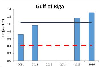
5 Results figure 2. Winter DIP concentrations (dark blue line; average for ) and threshold levels as agreed by HELCOM HOD (red dashed line). It should be noted that the results for Bornholm Basin strongly depend on stations in the open-sea area of Pomeranian Bay, which is influenced by the Odra plume. Results table 1. Threshold values, present concentration (as average ), eutrophication ratio (ER) and status of DIP in the open-sea basins. ER is a quantitative value for the level of eutrophication, calculated as the ratio between the threshold value and the present concentration when ER > 1, threshold value has not been reached (fail i.e not good status). Assessment unit (open sea) Threshold value (µmol l -1 ) Average (µmol l -1 ) Eutrophication ratio, ER Status (fail/achieve threshold value) Kattegat fail Great Belt fail The Sound fail Kiel Bay fail Bay of Mecklenburg fail Arkona Basin fail Bornholm Basin fail Gdansk Basin fail Eastern Gotland Basin fail Western Gotland Basin fail Gulf of Riga fail Northern Baltic Proper* fail Gulf of Finland* fail Aland Sea* fail Bothnian Sea* fail The Quark* fail Bothnian Bay* achieve *NOTE: Finnish monitoring open-sea estimates of phosphate and total phosphorus in are in general 10 % lower than in due to the changes in instrumentation and accompanying methodology. This might affect the indicator values in these assessment units. Of all coastal waters that were assessed, good eutrophication status is only found in some areas of the Swedish and Polish coastal waters (Results figure 1). Winter DIP concentrations were only assessed in the coastal and transitional waters of Latvia, Poland and Sweden (Results table2). In the Polish coastal waters 39% of the area (km 2 ) was in good status and 61% failed to achieve good status. In Swedish coastal waters > Baltic Sea trends > Indicators HELCOM 5
6 48% of the area was in good status, 7% was not assessed and 45% failed to achieve good status. In the coastal waters of Latvia 100% of the areas failed to achieve good status. Results table 2. Results for national coastal DIP indicators, as reported by countries. The table includes information on the assessment unit (CODE, defined in the HELCOM Monitoring and Assessment Strategy Annex 4), assessment period (start year and end year), average concentration during assessment period, threshold values, units, and Eutrophication Ratio (ER). The ER is coloured red or green to denote if the status evaluation has been failed or achieved, respectively. For Sweden - indicates only status provided and not raw result value, and note countries use different units in their reproting. In Swedish waters only the water bodies that were assessed are shown. ER is a quantitative value for the level of eutrophication, calculated as the ratio between the threshold value and the present concentration and forms the basis for the status assessment when ER > 1, threshold value has not been achieved and status is failed (not good). CODE Period Average Threshold value Units Eutrophication ratio (ER) LAT µmol l LAT µmol l LAT µmol l LAT µmol l LAT µmol l POL mg l POL mg l POL mg l POL mg l POL mg l POL mg l POL mg l POL mg l POL mg l POL mg l POL mg l POL mg l POL mg l POL mg l POL mg l POL mg l POL mg l POL mg l POL mg l SWE EQR 0.91 SWE EQR 0.91 SWE EQR 1.13 SWE EQR 1.36 SWE EQR 1.53 SWE EQR 1.98 SWE EQR 1.43 SWE EQR 1.50 SWE EQR 1.81 SWE EQR 1.81 SWE EQR 2.00 SWE EQR 2.90 SWE EQR 1.81 SWE EQR 0.93 SWE EQR > Baltic Sea trends > Indicators HELCOM 6
7 SWE EQR 0.78 SWE EQR 0.74 SWE EQR 0.94 SWE EQR 0.76 SWE EQR 0.78 SWE EQR 0.74 SWE EQR > Baltic Sea trends > Indicators HELCOM 7
8 Long-term trends The long-term trends are provided as additional information and do not influence the status assessment. For some basins, measurements reach back to the 1960s. After the marked increase of dissolved inorganic phosphate (DIP) that started in the 1960s and 1970s, concentrations generally remained at a high level, though strong fluctuations occur as a result of various internal processes and generally no clear trends can be seen in most assessment regions (Results figure 3). However the increase in DIP concentrations during recent years, particularly visible in the Bothnian Sea, Gulf of Riga, Gdansk Basin, Northern Baltic Proper and Åland Sea is interesting. Major Baltic Inflows (MBIs) are of great importance in this respect. After the MBIs of 1975/76, 1983 and 1993 lower phosphate concentrations in the subsequent years were measured, whereas a comparable decrease after the MBI of 2003 was not be observed, indicating that the vertical transport through the permanent halocline is not sufficiently understood. The historicity of the inflow events and the seasons of MBIs as well as the intensity and depth of vertical mixing must be considered (Nausch et al. 2008; Reissmann et al. 2009). The process is additionally complicated since mixing of oxygenated waters into sulfidic waters causes formation of manganese and iron phosphate precipitates (Dellwig et al., 2010) that cause transport of large amounts of phosphate to the sediments (Relevance figure 1). So it appears that the recent inflow with a short period of re-oxygenation mainly caused entrainment of phosphate into the surface waters, likely by increased turbulence and replacement of deeper waters. Based on the current data, intermittent removal by precipitation appeared quantitatively not so important. > Baltic Sea trends > Indicators HELCOM 8
9 > Baltic Sea trends > Indicators HELCOM 9
10 Result figure 3. Temporal development of winter dissolved inorganic phosphorus (DIP) concentrations in the open-sea assessment units from 1960s to Dashed lines show the five-year moving averages and error bars the standard deviation. Green lines denotes the indicator threshold. Significance of trends was assessed with Mann-Kendall nonparametric tests for period from Significant (p<0.05) deteriorating trends are indicated with orange data points. No significant improving trends were detected. > Baltic Sea trends > Indicators HELCOM 10

11 Confidence of the indicator status evaluation The confidence of the indicator status evaluation in open sea areas, based on the spatial and temporal coverage of data as well as the accuracy of the protocol for setting threshold values, was high in the Kattegat, Arkona and Bornholm Basin, low in The Sound, Gdansk Basin, Western Gotland Basin, Gulf of Riga, Åland Sea and The Quark, and moderate in all remaining sub-basins. The low confidence was caused by a lack of monitoring data. Results figure 4. Indicator confidence, determined combining information on data availability and the accuracy of the protocol for setting threshold values. Low indicator confidence calls for an increase in monitoring. The indicator confidence was estimated through confidence scoring of the threshold value (ET-Score) and the indicator data (ES-Score). The ET-Score was rated based on the uncertainty of the threshold value setting procedure. The ES-Score is based on the number as well as spatial and temporal coverage of the observations for the assessment period To estimate the overall indicator confidence, the ET- and ES-Scores were combined. See Andersen et al and Fleming-Lehtinen et al for further details. > Baltic Sea trends > Indicators HELCOM 11
. Thresholds figure 1.")
12 Thresholds and Status evaluation Status evaluation is measured in relation to scientifically based and commonly agreed sub-basin specific threshold value, which defines the concentration that should not be exceeded (Thresholds figure 1). Thresholds figure 1. Schematic representation of the threshold values applied in the DIP core indicator, the threshold values are assessment unit specific (see Thresholds table 1). These indicator threshold values were based on the results obtained in the TARGREV project (HELCOM 2013a), also taking advantage of the work carried out during the EUTRO PRO process (HELCOM 2009) and national work for EU WFD. The final threshold values were set through an expert evaluation process done via intersessional activity for the development of core eutrophication indicators (HELCOM CORE EUTRO), and the targets were adopted by the HELCOM Heads of Delegations 39/2012. Thresholds table 1. Assessment unit specific threshold values for the DIP core indicator. HELCOM_ID Assessment unit (open sea) Threshold value (μmol l 1) SEA-001 Kattegat 0.49 SEA-002 Great Belt 0.59 SEA-003 The Sound 0.42 SEA-004 Kiel Bay 0.57 SEA-005 Bay of Mecklenburg 0.49 SEA-006 Arkona Basin 0.36 SEA-007 Bornholm Basin 0.30 SEA-008 Gdansk Basin 0.36 SEA-009 Eastern Gotland Basin 0.29 SEA-010 Western Gotland Basin 0.33 SEA-011 Northern Baltic Proper 0.25 SEA-012 Gulf of Riga 0.41 SEA-013 Gulf of Finland 0.59 SEA-014 Åland Sea 0.21 SEA-015 Bothnian Sea 0.19 SEA-016 The Quark 0.10 SEA-017 Bothnian Bay > Baltic Sea trends > Indicators HELCOM 12
13 Assessment Protocol The open-sea core indicators are updated using data reported by Contracting Parties to the HELCOM COMBINE database hosted by ICES, using the algorithms developed for the eutrophication assessment work flow. The reporting values are collated based on the indicators specifications shown in Assessment protocol table 1 (see HELCOM Eutrophication assessment manual). Assessment protocol table 1. Specifications for the DIP indicator. Indicator DIP Response to Positive eutrophication Parameters DIP = PO4 concentration (µm) Data source Monitoring data provided by the HELCOM Contracting Parties, and kept in the HELCOM COMBINE database, hosted by ICES ( Assessment period Assessment season Winter = December + January + February Depth Surface = average in the 0 10 m layer Removing outliers No outliers removed Removing close No close observations removed observations Indicator level Average of annual average concentrations Eutrophication ratio (ER) ER = ES / ET Status confidence (ES- LOW (=0%), if no more than 5 annual status observations are found Score) during one or more years. MODERATE (=50%), if more than 5 but no more than 15 status observations are found per year. HIGH (=100%), if more than 15 spatially non-status observations are found each year. Indicator threshold value MODERATE confidence Indicator confidence (I- Confidence (%) = average of ES-Score and ET-Score Score) Assessment units The core indicator is applicable in the 17 open sea assessment units (at least one nautical mile seawards from the baseline). In the coastal units the indicator is assessed using comparable indicators developed nationally for the purposes of assessments under the EU Water Framework Directive. The assessment units are defined in the HELCOM Monitoring and Assessment Strategy Annex 4. > Baltic Sea trends > Indicators HELCOM 13
14 Relevance of the Indicator Eutrophication assessment The status of eutrophication is assessed using several core indicators. Each indicator focuses on one important aspect of the complex issue. In addition to providing an indicator-based evaluation of the dissolved inorganic phosphorous, this indicator will also contribute to the overall eutrophication assessment along with the other eutrophication core indicators. Policy relevance Eutrophication is one of the four thematic segments of the HELCOM Baltic Sea Action Plan (BSAP) with the strategic goal of having a Baltic Sea unaffected by eutrophication (HELCOM 2007). Eutrophication is defined in the BSAP as a condition in an aquatic ecosystem where high nutrient concentrations stimulate the growth of algae, which leads to imbalanced functioning of the system. The goal for eutrophication is broken down into five ecological objectives, of which one is concentrations of nutrients close to natural levels. The EU Marine Strategy Framework Directive (Anonymous 2008) requires that human-induced eutrophication is minimized, especially adverse effects thereof, such as losses in biodiversity, ecosystem degradation, harmful algal blooms and oxygen deficiency in bottom waters (Descriptor 5). Nutrients in the watercolumn (incl DIP) are the criteria elements for assessing eutrophication under the criterion D5C1 Nutrient concentrations are not at levels that indicate adverse eutrophication effects. The EU Water Framework Directive (Anonymous 2000) requires good ecological status in the European coastal waters. Good ecological status is defined in Annex V of the Water Framework Directive, in terms of the quality of the biological community, the hydromorphological characteristics and the chemical characteristics, including phosphorus concentration. Role of dissolved inorganic phosphorous (DIP) in the ecosystem Marine eutrophication is mainly caused by nutrient enrichment leading to increased production of organic matter supplied to the Baltic Sea with subsequent effects on water transparency, phytoplankton communities, benthic fauna and vegetation as well as oxygen conditions. Phytoplankton as well as benthic vegetation need nutrients, mainly nitrogen and phosphorus, for growth. Phosphorus is the important limiting nutrient since nitrogen could be replenished by nitrogen fixation. So phosphorus surplus could foster primary production, especially by diazotrophic cyanobacterial blooms. > Baltic Sea trends > Indicators HELCOM 14

15 Relevance figure 1. Simplified conceptual model for N and P nutrients in the Baltic Sea, where DIN = Dissolved inorganic nitrogen, TN = Total nitrogen, DIP = Dissolved inorganic phosphorus and TP = Total phosphorus. Flows along arrows into the blue sea area tend to increase concentrations, and flows along arrows out from the sea act in the opposite direction. Management refers to nutrient load reductions. Human pressures linked to the indicator General MSFD Annex III, Table 2a Strong link Weak link Substances, litter and energy - Input of nutrients diffuse sources, point sources, atmospheric deposition Nutrient concentrations in the water column are affected by increased anthropogenic nutrient loads from land and air. > Baltic Sea trends > Indicators HELCOM 15
16 Monitoring Requirements Monitoring methodology Monitoring of DIP in the Contracting Parties of HELCOM is described on a general level in the HELCOM Monitoring Manual in the sub-programme Nutrients. Monitoring guidelines specifying the sampling strategy are adopted and published. Current monitoring The monitoring activities relevant to the indicator that are currently carried out by HELCOM Contracting Parties are described in the HELCOM Monitoring Manual Sub-programme: monitoring concepts table Description of optimal monitoring Regional monitoring of dissolved organic phosphorous is considered sufficient to support the indicator evaluation. > Baltic Sea trends > Indicators HELCOM 16
17 Data and updating Access and use The data and resulting data products (tables, figures and maps) available on the indicator web page can be used freely given that the source is cited. The indicator should be cited as following: HELCOM (2018) Dissolved inorganic phosphorus (DIP). HELCOM core indicator report. Online. [Date Viewed], [Web link]. ISSN Result: Dissolved inorganic phosphorus Metadata Data source: The average for was estimated using monitoring data provided by the HELCOM Contracting Parties, and kept in the HELCOM COMBINE database, hosted by ICES ( Nominated members of HELCOM STATE & CONSERVATION group were given the opportunity to review the data, and to supply any missing monitoring observations, in order to achieve a complete dataset. Description of data: The data reflect in situ phophate concentrations, determined using colorimetric methods, as explained in the HELCOM COMBINE manual. In the assessment, only surface water measurements at depths of 0-10 m are reported. Geographical coverage: The observations are distributed in the sub-basins according to the HELCOM COMBINE programme, added occasionally with data from research cruises. Temporal coverage: The raw data includes observations throughout the year, during the assessment period Data aggregation: The averages for each sub-basin were produced as an inter-annual winter (December-February) estimates. > Baltic Sea trends > Indicators HELCOM 17
18 Contributors and references Contributors Vivi Fleming-Lehtinen 1, Marina Carstens 2, Wera Leujak 3, Joachim Küss 4, Wojciech Kraśniewski 5, Joni Kaitaranta 6, Laura Hoikkala 6, HELCOM Expert Network on Eutrophication 1 Finnish Environment Institute, SYKE, Finland 2 State Agency for Environment, Nature Protection and Geology Mecklenburg-Vorpommern, Germany 3 German Federal Environment Agency, Germany 4 Leibniz Institute for Baltic Sea Research Warnemünde (IOW), Germany 5 Institute of Meteorology and Water Management, National Research Institute, Poland 6 Secretariat of the Helsinki Commission Archive This version of the HELCOM core indicator report was published in July 2018: Dissolved inorganic phosphorus DIP HELCOM core indicator 2018 (pdf) Older versions of the core indicator report are available: HOLAS II component - Core indicator report web-based version July 2017 (pdf) DIP concentrations (pdf) Nutrient concentrations HELCOM Core Indicator Report (pdf) References Andersen, J. H., Murray, C., Kaartokallio, H., Axe, P. & Molvær, J. (2010). Confidence rating of eutrophication status classification. Marine Pollution Bulletin 60, Anonymous (2000). Directive 200/60/EC of the european parliament and of the council of 23 October 2000 establishing a framework for community action in the field of water policy. Official Journal of the European Communities L 327/1. Anonymous (2008) Directive 2008/56/EC of the European Parliament and of the Council. 17 June Establishing a Framework for Community Action in the Field of Marine Environmental Policy. Marine Strategy Framework Directive. 22p. Carstensen J, D.J. Conley, J.H. Andersen, G. Ærtebjerg (2006). Coastal eutrophication and trend reversal: a Danish case study. Limnology & Oceanography 51: Dellwig, O., Leipe, T., März, C., Glockzin, M., Pollehne, F., Schnetger, B., Yakushev, E. V., Böttcher, M. E., and Brumsack, H.-J. (2010). A new particulate Mn Fe P-shuttle at the redoxcline of anoxic basins, Geochimica et Cosmochimica Acta, 74, > Baltic Sea trends > Indicators HELCOM 18
19 Fleming-Lehtinen, V., Andersen, J. H., Carstensen, J., Łysiak-Pastuszak, E., Murray, C., Pyhälä, M. & Laamanen, M. (2015). Recent developments in assessment methodology reveal that the Baltic Sea eutrophication problem is expanding. Ecological Indicators 48, HELCOM (2007) Baltic Sea Action Plan. Baltic Sea Environment Protection Commission. 101p. Nausch, G., R. Feistel, H.U. Lass, K. Nagel, H. Siegel (2008): Hydro-graphisch-chemische Zustandseinschätzung der Ostsee Marine Science Report, Baltic Sea Research Institute Warnemünde, 72, Reissmann J.H., H. Burchard, R.F.E. Hagen, H.U. Lass, V.M.G. Nausch, L. Umlauf, G. Wieczorek (2009) Vertical mixing in the Baltic Sea and consequences for eutrophication a review. Progress in Oceanography, 82, pp Additional relevant publications HELCOM: First version of the State of the Baltic Sea report June 2017, Baltic Marine Environment Protection Commission HELCOM, Helsinki, Finland, 197, Eutrophication status of the Baltic Sea A concise thematic assessment (2014) Approaches and methods for eutrophication target setting in the Baltic Sea region (2013) HELCOM core indicators. Final report of the HELCOM CORESET project (2013) Eutrophication in the Baltic Sea. An integrated thematic assessment of the effects of nutrient enrichment in the Baltic Sea region (2009) Development of tools for assessment of eutrophication in the Baltic Sea (2006) HELCOM core indicator report, ISSN > Baltic Sea trends > Indicators HELCOM 19