Public Notice. Middle Fork Vermilion River, Oakwood, IL. Latitude: Longitude: Minute Quad: Danville NW
|
|
|
- Olivia Benson
- 5 years ago
- Views:
Transcription

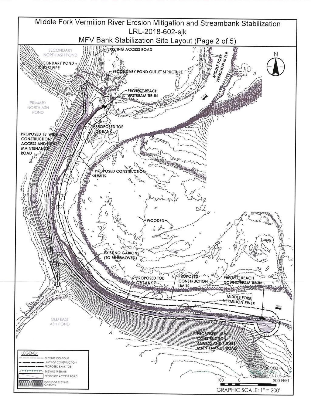
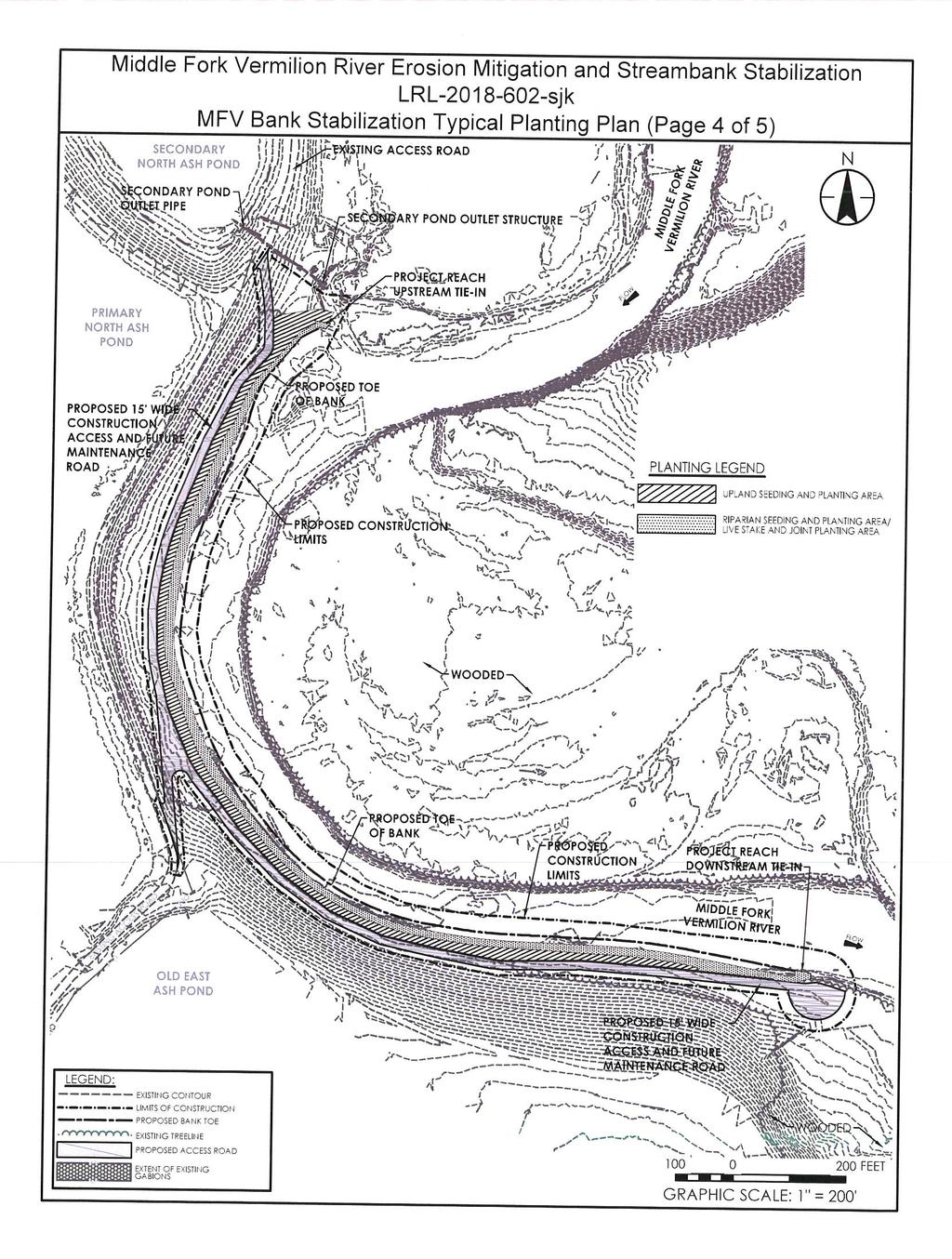
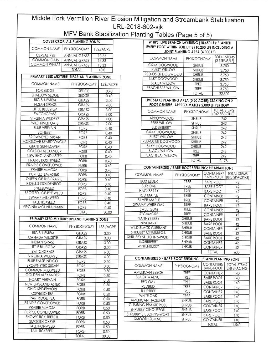
1 Public Notice US Army Corps of Engineers Public Notice No. LRL sjk Open Date: 26 Nov 2018 Closing Date: 10 Jan 2018 Louisville District Please address all comments and inquiries to: U.S. Army Corps of Engineers, Louisville District ATTN: Sarah Keller 8902 Otis Avenue, Suite S106B Indianapolis, IN Phone: (317) This notice announces an application submitted for a Department of the Army (DA) Permit, subject to Section 404 of the Clean Water Act: APPLICANT: LOCATION: Dynegy Midwest Generation, LLC 1500 Eastpoint Plaza Drive Collinsville, IL Middle Fork Vermilion River, Oakwood, IL Latitude: Longitude: Minute Quad: Danville NW PURPOSE: Construction of streambank stabilization. DESCRIPTION OF WORK: The applicant proposes to discharge fill material below the ordinary high water mark of 2,000 linear feet of the right descending bank of the Middle Fork Vermilion River utilizing a combination of 11,500 cubic yards (cys) of void-filled riprap and stone toe protection, 2,000 cys of clean soil, and live branch layering. Approximately 9,000 cys of existing bed and bank material (including existing gabion baskets) below the ordinary high water mark would be excavated and removed offsite. AVOIDANCE, MINIMIZATION, AND MITIGATION MEASURES: The applicant has considered multiple alternatives to further minimize proposed impacts to waters of the United States, some of which would result in an increase in erosion and sediment loading and a greater impact to aesthetic appearance of the banks in comparison to the preferred alternative. Additionally, the applicant has prepared a storm water pollution prevention plan that would include best management practices to be utilized during the construction activity. Compensatory mitigation has not been proposed. SPECIAL PROVISIONS: This portion of the Middle Fork Vermilion River has been designated as a component of a State and/or Federal Wild and Scenic River System. A DA permit cannot be issued until it has been determined that the proposed project will not have a direct and adverse effect on the values for which the stream was established as a wild and scenic river. 1
2 REVIEW PROCEDURES: A DA Permit cannot be issued if any legally required Federal, State, or local authorization or certification is denied. A DA permit, if otherwise warranted, will not be issued until a State of Illinois Section 401 Water Quality Certification or waiver is on file at this office. The applicant has submitted an application for State certification from the Illinois Environmental Protection Agency (ILEPA). Copies of this notice are sent to the appropriate Federal and State Fish and Wildlife Agencies. Their views and comments are solicited in accordance with the Fish and Wildlife Coordination Act of The Endangered Species Act (ESA, 87 Stat. 884, as amended; 16 U.S.C et seq.) requires federal agencies to consult with the U.S. Fish and Wildlife Service (USFWS) pursuant to Section 7(a) 2 of the ESA on all actions that may affect a species listed (or proposed for listing) under the ESA as threatened or endangered, or any designated critical habitat. A copy of this notice is being furnished to the USFWS for their review. Per this notification, we request comments from the USFWS concerning potential impact to threatened and/or endangered species. After receipt of comments, the USACE will evaluate the potential impacts to proposed and/or listed species and their designated critical habitat and initiate consultation with USFWS, if required. Any person may request, in writing, within the comment period specified in this notice, that a public hearing be held to consider this application. A request for a public hearing must state the specific interest which might be damaged by issuance of the DA Permit. The National Register of Historic Places has been examined, and it has been determined that there are no properties currently listed on the Register which would be directly affected by the proposed work. If we are made aware, as a result of comments received in response to this notice, or by other means, of specific archaeological, scientific, prehistoric, or historical sites or structures which might be affected by the proposed work, the District Engineer will immediately take the appropriate action necessary pursuant to the National Historic Preservation Act of 1966 Public Law as amended (including Public Law ). The decision whether to issue a permit will be based on an evaluation of the probable impact of the proposed activity on the public interest. That decision will reflect the national concern for both protection and utilization of important resources. The benefits which reasonably may be expected to accrue from the proposal must be balanced against its reasonably foreseeable detriments. All factors which may be relevant to the proposal will be considered; among those are conservation, economics, aesthetic values, general environmental concerns, historic values, fish and wildlife values, flood damage prevention, land use, navigation, recreation, water supply, water quality, energy needs, safety, food production, and in general, the needs and welfare of the public. In addition, the evaluation of the impact of the activity on the public interest will include application of the guidelines (40 CFR Part 230) promulgated by the Administrator, United States Environmental Protection Agency, under authority of Section 404(b) of the CWA. The Corps of Engineers is soliciting comments from the public; Federal, State, and local agencies and officials; Indian tribes; and other interested parties in order to consider and evaluate the impacts of this proposed activity. It is presumed that all interested parties and agencies will wish to respond; therefore, a lack of response will be interpreted as meaning that there is no objection to the proposed project. Any comments received will be considered by the Corps of Engineers to determine whether to issue, modify, condition or deny a permit for this proposal. To make this 2
3 decision, comments are used to assess impacts on endangered species, historic properties, water quality, general environmental effects, and the other public interest factors listed above. Comments are used in the preparation of an Environmental Assessment and/or an Environmental Impact Statement pursuant to the National Environmental Policy Act. Comments are also used to determine the need for a public hearing and to determine the overall public interest of the proposed activity. Written statements received in this office on or before the closing date will become a part of the official record and will be considered in the determination on this permit request. Any objections which are received during this period will be forwarded to the applicant for possible resolution before the determination is made whether to issue or deny the requested DA Permit. A permit will be granted unless its issuance is found to be contrary to the public interest. Information pertaining to this application is available for public examination during normal business hours upon prior request. Drawings are available on Louisville District's Internet site at All comments regarding this proposal should be addressed to Ms. Sarah Keller at the address noted above and should refer to the Public Notice Number LRL sjk. If you desire to submit your comments by , you must comply with the following: a) In the subject line of your , type in ONLY the Public Notice ID No. LRL sjk Example: Subject: LRL sjk b) Provide your physical mailing address and telephone number. c) Send your to: lrl.regulatorypubliccomment@usace.army.mil d) If you are sending attachments greater than 1 Mb in size with your , you must send a hard copy (CD or paper) to the Corps physical address as well. 3
4
5
6
7
8