Midwest Technology Assistance Center Groundwater Resource Assessment for Small Communities
|
|
|
- Abel McLaughlin
- 5 years ago
- Views:
Transcription
 at the Illinois State Water Survey.")
1 Midwest Technology Assistance Center Groundwater Resource Assessment for Small Communities Groundwater Availability At Fayette Water Company, Illinois (Fayette County) Project Overview This project is an outgrowth of the Public Service Program of the Center for Groundwater Science (CGS) at the Illinois State Water Survey. For over 50 years, the CGS has provided groundwater information to any requesting individual, commercial facility or public water facility. Groundwater resource assessments have been an integral part of this public service and have been undertaken for thousands of individuals and facilities throughout its history. Community groundwater supplies that have been identified as potentially deficient are the targets for this project. The criterion used for determining community deficiency were; 1) Water Supply and Demand (operating time), 2) Aquifer Limitation, 3) Well Specific Capacity, and 4) Facility History. The Village of Fayette Water Company has been identified as a target community for groundwater assessment through this project. Project Goal To provide a resource tool of pertinent groundwater information to each target facility. This document describes a summary of historic information, current conditions and the potential for expansion of the water supply within 5 and 10 miles of Fayette Water Company. Fayette Water Company (Fayette County) 1
2 Fayette Water Company (Facility Number ) obtains its water from four community water supply wells. Wells Nos. 2, 3, 4, and 5 (Illinois EPA Nos , 01014, 01015, and XXXXX respectively) provided approximately 156 million gallons annually to a population of about 7,000 in Facilities that obtain water from Fayette Water Company include Bownstown, St. Elmo, Beecher City, and St. Peter. The project criterion ranked Fayette Water Company as marginal mainly due to its shallow water table wells and a history of highly variable sand formations found throughout this area. Historic Information Background Well Information Well No. 2 Finished in shallow sand and gravel deposits located in Section 32, T.8N., R.2E., Fayette County. The well was drilled to a depth of 47 feet in 1994 and was tested at a rates ranging from 175 to 300 gpm for short periods of time. The nonpumping water level was reported at ft below land surface and, at the end of the test, water levels declined to ft. Well No. 3 Finished in sand and gravel deposits located in the Section 32, T.8N., R.2E., Fayette County. The well was drilled to a depth of 44 feet in 1994 and, upon completion, was pumped at 385 gallons per minute (gpm) for 4 days with approximately 17 feet of drawdown. Calculated specific capacity from this test was 22.6 gpm/ft. Static water level was reported as 9.9 feet below land surface. Well No. 4 Finished in sand and gravel deposits located in the Section 32, T.8N., R.2E., Fayette County. The well was drilled to a depth of 40 feet in 1998 and, upon completion, was pumped at 200 gpm for 2 hours with approximately 8 feet of drawdown. Static water level was reported as 12 feet below land surface. Well No. 5 Finished in sand and gravel deposits located in the Section 31, T.8N., R.2E., Fayette County. The well was drilled to a depth of 48 feet in 2003 and, upon completion was pumped at 299 gpm for 12 hours with approximately 19 feet of drawdown. Static water level was reported as 12.5 feet below land surface. Well No. 6 (unused in 2007) Finished in sand and gravel deposits located in the Section 31, T.8N., R.2E., Fayette County. The well was drilled to a depth of 51 feet in 2003 and, upon completion was pumped at 299 gpm for 12 hours with approximately 12.5 feet of drawdown. Static water level was reported as 13.6 feet below land surface. 2
3 Well No. 7 (proposed in 2007) To be finished in sand and gravel deposits located in the Section 31, T.8N., R.2E., Fayette County. Test drilling to a depth of 51.5 feet indicated coarse sand and gravel for development. Background Pumpage Information Fayette Water Company Pumpage Gallons Well 5 Well 4 Well 3 Well Year Source: ISWS Illinois Water Inventory Program Historic Population Information Fayette Water Company Population Population Year Source: ISWS Illinois Water Inventory Program
4 Regional Information Resources within 5 miles of Fayette Water Company (Figure 1). Domestic Groundwater Supplies The available regional data indicate that groundwater for domestic and farm use in the old well field area (Section 18, T.8N., R.1E.) is obtained from largediameter dug and bored wells finished in the unconsolidated materials above bedrock and from small-diameter drilled wells tapping the shallow underlying bedrock formations. The large-diameter dug and bored wells tap stringers or lenses of silt, sand, or gravel only a few inches thick contained in the unconsolidated materials above bedrock. They range in depth from about 25 to 51 feet. The yield of this type of well is limited to a few hundred gallons per day and may be only barely adequate for normal household uses. Only one small-diameter (4- to 6-inch) well has been reported to have been drilled into the underlying Pennsylvanian bedrock in this area. It was also reported to be a dry hole. Municipal Groundwater Supplies There are two towns located within five miles of Fayette Water Company well field; Island Hill to the east and the Dean Hills to the northeast. Neither town reports a municipal water supply so it is assumed that the residents use domestic wells for their water needs Resources within 10 miles of Fayette Water Company (Figure 2). Municipal Groundwater Supplies Towns within 5 to 10 miles of Fayette Water Company include: Hanson and Herrick in Shelby County, and Bayle City, Ramsey, Wrights Corner, Vera, Pruett, St. Elmo, Avena, Brownstown, and Bluff City, all in Fayette County. The villages of Hanson, Bayle City, Wrights Corner, Vera, Pruett, Avena, and Bluff City report no water for their town through the use of municipal wells. It is assumed that the residents water needs are fulfilled through domestic private wells at these locations. The villages of St. Elmo, Brownstown, St Peter and Beecher City currently receive water from the Fayette Water Company. The Village of Herrick currently uses two wells located in Sections 25 and 26, T.9N., R.2E., Shelby county. The wells are finished in sand and gravel associated with Mitchell Creek at depths of 78 and 80 feet below land surface. Current information indicates these wells are pumped at rates around 50 gpm for the village needs. The Village of Ramsey obtains its water from one active community water supply well. Well No. 7 is finished in coarse sand and gravel associated with the 4
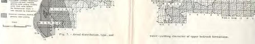
5 Kaskaskia River. It is located in the Northwest quarter of Section 32, T.8N., R.2E., Fayette County. The well was drilled to a depth of 45 feet in 1995 and, upon completion, produced over 400 gallons per minute (gpm) for 22 hours with approximately 16ft of drawdown. Calculated specific capacity from this test was 25.8 gpm/ft. Static water level was reported as 8.5 feet below land surface. Well No. 6 is finished in shallow sand and gravel deposits located in Section 18, T.8N., R.1E., Fayette County. The well was drilled to a depth of 41 feet in 1980 and, upon completion, reportedly produced 150 gpm for 2 hours with 6.9 feet of drawdown. Calculated specific capacity from this test was 21.6 gpm/ft. Static water level was reported as feet below land surface. This well is used as an emergency backup to Well No. 7. Figures 3 and 4 picture the ISWS Potential Yield maps for sand and gravel and bedrock aquifer in Illinois, respectively. The pertinent counties for Fayette Water Company are highlighted. Figure 3 indicates that sand and gravel deposits are variable throughout most of the Fayette Water Company area with the exception of the alluvial sand and gravel deposits to the west and east associated with the Kaskaskia River. The bedrock map (Figure 4) indicates poor availability of groundwater from the bedrock throughout the Fayette Water Company area. Figures 5 and 6 present the probability of occurrence of the sand and gravel and the water-yielding character of the shallow bedrock for the Fayette Water Company area as depicted in the Illinois State Geologic Survey Circular 225, Groundwater Geology in South-Central Illinois (Selkregg, et al., 195). Figure 5 indicates Good to Excellent conditions along the Kaskaskia River and Fair to Good variability in other parts of the county for sand and gravel deposit development. Figure 6 indicates only small supplies are available from the shallow bedrock units. The domestic well construction records verify these map outlooks. Groundwater Availability Summary The available information indicates that the sand and gravel deposits that the Fayette Water Company currently uses in the Kaskaskia River bottoms are capable of supplying the current needs of the company (T.8N., R.2E., Sections 31 and 32, Fayette County). Section 32 was the area that was studied and analyzed by the Illinois State Water Survey in 1996 (Sanderson, 1996). That analysis indicated the potential for a 1.5 million gallon per day (mgd) water supply from two well fields in this general location. The production information from the Illinois Water Inventory Program (Page 3 of this document), indicates that the Water Company has been pumping just under 500,000 gallons per day since it began. Well Nos. 2, 3, and 4, located in Section 32, produce the bulk of the needed groundwater with Well No. 5 also being used in 2007 (Section 31, to the south). Well No. 6 has not been reported to be used in
6 It is unknown whether the pumpage of Well No. 5 has any impact on Well Nos. 2, 3, or 4. Water level measurements would be required to determine any potential impact between these two locations. Additional drawdown from simultaneous pumpage of all these wells would indicate the sand and gravel deposits are limited within the locations of these wells and, may require the development of a new well field, away from the current wells. Sanderson (1996) indicated there are two other locations that could be explored for future development; the southwest corner of Section 31, T.8N., R.2E., and the west-central boundary of Section 6, T.7N., R.2E. (Figure 7). Available information suggests that the current needs of the Fayette Water Company are being met with the existing water wells and that the current system is not yet operating at its maximum yield. Sanderson suggested a yield of 1.5 mgd could be possible from two well fields. Should the need arise for a second well field, the Kaskaskia River bottoms to the south of the existing well field, should be considered. 6
7 Figure 1. 5-mile radius map- Fayette Water Company
8 Figure mile radius map- Fayette Water Company
9 Figure 3. 9
10 Figure 4. 10

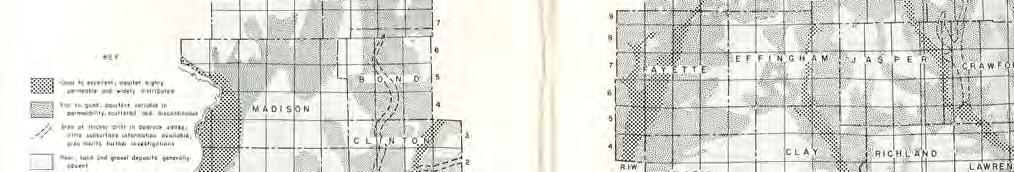
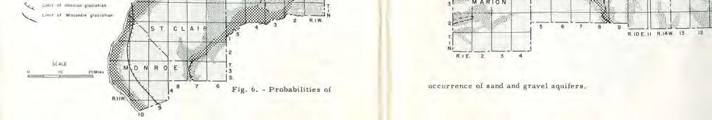
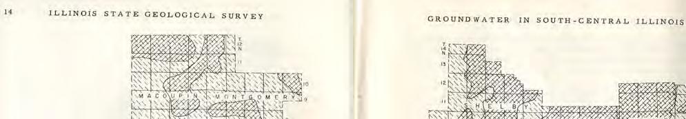
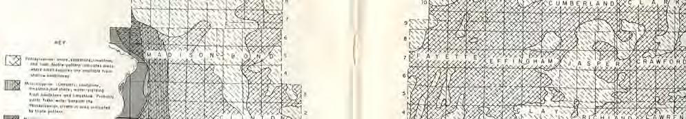
11 Figure 5. Figure 6. 11
12 Figure 7. Possible convenient sites for exploration for a second well field. (Sanderson, 1996) 12
13 References Sanderson, Ellis W Ground-Water Investigation in the Kaskaskia River Valley, Fayette County, Illinois. Illinois State Water Survey Contract Report 592. Selkregg, L.F., W. A. Pryor, and J. Kempton Groundwater Geology In South-Central Illinois, A preliminary Geologic Report. Illinois State Geological Survey Circular 225. ISWS publications list for the Fayette Water Company and surrounding areas. CLAY *1981 COOP-7 Procedures for the collection of representative water quality data from monitoring wells. Gibb-Schuller-Griffin. 66p. EFFINGHAM *1965 RI-53 Potential yield of aquifers in Embarras River Basin, Illinois. Walton-Csallany. Open File Report. *1966 RI-55 Yields of wells in Pennsylvanian and Mississippian rocks in Illinois. Csallany. 42p RI-70 Plans for meeting water requirements in the Kaskaskia River Basin, Singh-Visocky-Lonnquist. 24p. *1978 CR-209 Assessment of public groundwater supplies in Illinois. Visocky-Wehrmann- Kim-Ringler. 193p. *1980 CR-237 Assessment of eighteen public groundwater supplies in Illinois. Wehrmann-Visocky-Burris-Ringler-Brower. 185p COOP-14 Pilot Study: Agricultural chemicals in rural, private wells in Illinois. Schock-Mehnert-Caughey-Dreher-Dey-Wilson-Ray- Chou-Valkenburg-Gosar-Karny-Barnhardt-Black-Brown-Garcia. 84p COOP-15 Characterization of the study areas for the Pilot Study: Agricultural chemicals in rural, private wells in Illinois. Barnhardt-Mehnert-Ray-Schock. 114p. 13
14 FAYETTE *1965 RI-53 Potential yield of aquifers in Embarras River Basin, Illinois. Walton-Csallany. Open File Report RS-48 Relationship between water use and population in the Embarras River Basin, Illinois. Csallany. *1966 RI-55 Yields of wells in Pennsylvanian and Mississippian rocks in Illinois. Csallany. 42p. *1969 RI-62 Groundwater resources of the buried Mahomet Bedrock Valley. Visocky-Schicht. 52p. *1978 CR-196 Water supply alternatives for the city of Danville. Singh. 124p. *1978 CR-199 Reconnaissance study of final cut impoundments. Gibb-Evans. 101p. *1978 CR-209 Assessment of public groundwater supplies in Illinois. Visocky-Wehrmann-Kim- Ringler. 193p. *1980 CR-237 Assessment of eighteen public groundwater supplies in Illinois. Wehrmann- Visocky-Burris-Ringler-Brower. 185p COOP-8 Hydrogeologic evaluation of sand and gravel aquifers for municipal groundwater supplies in east-central Illinois. Kempton-Morse-Visocky. 59p COOP-10 Geology, hydrology, and water quality of the Cambrian and Ordovician Systems in northern Illinois. Visocky-Sherrill-Cartwright. 136p. MARION *1966 RI-55 Yields of wells in Pennsylvanian and Mississippian rocks in Illinois. Csallany. 42p RI-70 Plans for meeting water requirements in the Kaskaskia River Basin, Singh-Visocky-Lonnquist. 24p. *1981 COOP-7 Procedures for the collection of representative water quality data from monitoring wells. Gibb-Schuller-Griffin. 66p. 14