Modelling the impact of land use change on the water balance in the Xiangxi Catchment (Three Gorges Region, China) using SWAT
|
|
|
- Dinah Bryan
- 5 years ago
- Views:
Transcription


1 Modelling the impact of land use change on the water balance in the Xiangxi Catchment (Three Gorges Region, China) using SWAT K. Bieger, B. Schmalz, Q. Cai, N. Fohrer 2010 International SWAT Conference Seoul 6th of August, 2010 Department of Hydrology and Water Resources Management
2 Outline 1. Introduction 2. YANGTZE Project 3. Study area 4. SWAT model application 5. Outlook Department of Hydrology and Water Resources Management K. Bieger -2-
3 1. Introduction


4 Three Gorges Dam Department of Hydrology and Water Resources Management K. Bieger -4-


5 Land use change Uphill shift of agricultural areas Resettlement Construction of infrastructure Department of Hydrology and Water Resources Management K. Bieger -5-


6 Impact on water balance and quality Alteration of runoff and evaporation processes Risk of increasing diffuse inputs to rivers because of increase in erosion and landslides Higher potential of eutrophication due to limited exchange of water in Three Gorges Reservoir Picture: S. Schönbrodt 2010 Picture: D. Ehret 2010 Picture: X. Jiang 2007 Picture: X. Jiang 2007 Department of Hydrology and Water Resources Management K. Bieger -6-
7 2. YANGTZE-Project
8 Project collaboration YANGTZE-Project: land use change, erosion, mass movement, diffuse inputs Coordination: Research Centre Jülich Remote Sensing Potsdam Land use change Giessen Erosion Tübingen Landslides Erlangen Diffuse sediment and P inputs Kiel Assessment of mass movements using remote sensing techniques Classification of land use and assessment of vulnerability Assessment and analysis of soil erosion Assessment and analysis of landslides Analysis of sediment and phosphorus inputs to rivers using SWAT Aim: Analysis of land use change and vulnerability, risk assessment of mass movements, soil erosion and diffuse inputs to rivers Department of Hydrology and Water Resources Management K. Bieger -8-
9 Objectives Assessment of the impact of land use change on water quantity and quality in the Xiangxi Catchment How has the changing land use in the last 20 years influenced the water balance and diffuse inputs? How will possible future land use patterns affect these factors? Development of sustainable land use options for the Three Gorges Region Department of Hydrology and Water Resources Management K. Bieger -9-
10 Methods SWAT2009 Water balance, sediment, phosphorus Past and present land use ( ) Land use scenarios Study area: Xiangxi Catchment Example for a catchment impacted by a large dam project Methods and results to be transferable to similar regions Department of Hydrology and Water Resources Management K. Bieger -10-
11 3. Study area

12 Location of study area Department of Hydrology and Water Resources Management K. Bieger -12-
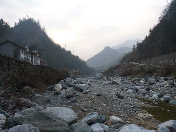
13 Xiangxi River Length of river: 94 km Catchment area: 3099 km 2 Mean annual discharge (Gauge Xingshan): 65.5 m 3 /s Mean annual temperature/ precipitation: 16.9 C/1000 mm Xiangxi Bay: Influence of Three Gorges Reservoir impoundment Department of Hydrology and Water Resources Management K. Bieger -13-
14 4. SWAT model application
 Steep slopes Mean 24 (46%) Maximum 76 (414%) Department of Hydrology and Water Resources Management K.")
15 Spatial input data I: DEM SRTM 3, Version 4 (CGIAR-CSI): resolution 90 m, resampled to 45 m Large differences in elevation (>3000 m) Steep slopes Mean 24 (46%) Maximum 76 (414%) Department of Hydrology and Water Resources Management K. Bieger -15-
 Department of Hydrology and Water Resources Management K.")
16 Spatial input data II: soil map Digitized from analogue soil maps of the counties Shennongjia, Xingshan and Zigui (1: and 1:180000) (Schönbrodt & Scholten 2009) Dominating soils: Limestone soil and Yellow brown soil Attributes taken from Chinese Soil Database ( Department of Hydrology and Water Resources Management K. Bieger -16-
17 Spatial input data III: land use maps Land use class Change (km 2 ) Change (%) Woodland Arable land Orchard Grassland Built-up area Bare rock Reservoir Major changes especially close to Xiangxi Bay, rivers and roads! Land use maps for 1987 and 2007 classified from Landsat-TM images (Seeber et al. 2010) Classification of further scenes planned Department of Hydrology and Water Resources Management K. Bieger -17-
18 Model setup I: watershed delineation Threshold: 4500 ha 37 subbasins 1 subbasin outlet added manually at Gauge Xingshan 38 subbasins 1 point source added to each subbasin Reservoirs in subbasins 18 and 22 Department of Hydrology and Water Resources Management K. Bieger -18-


19 Model setup II: HRU definition Soil (Schönbrodt & Scholten 2009) Land use (Seeber et al. 2010) Slope (SRTM) Threshold: 0% Threshold: 10% Threshold: 10% 5 slope classes: 26, 39, 50, 65, Hydrologic Response Units Department of Hydrology and Water Resources Management K. Bieger -19-
20 Model setup III: Climate data 3 climate stations: Xingshan, Zigui, Shennongjia Precipitation Temperature Wind speed Humidity Solar radiation (calculated from sunshine duration) Weather generator: climate station Xingshan ( ) Department of Hydrology and Water Resources Management K. Bieger -20-
21 Model setup IV: Simulation Discharge data (Gauge Xingshan): Warm-up: Calibration: Validation: Model evaluation statistics: NSE R 2 PBIAS RMSE Department of Hydrology and Water Resources Management K. Bieger -21-
22 Uncalibrated simulation: discharge NSE: R 2 : 0.62 PBIAS: RMSE: Department of Hydrology and Water Resources Management K. Bieger -22-
23 Analysis of weak points Peaks caused by a number of Runoff too low in winter and spring consecutive, smaller rainfall events are underestimated Peaks caused by single, large rainfalls are overestimated Department of Hydrology and Water Resources Management K. Bieger -23-


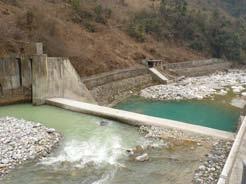
24 Specific characteristics of the catchment Steep slopes Terraces Reservoirs Hydropower stations Picture: C. Seeber 2009 Department of Hydrology and Water Resources Management K. Bieger -24-
25 5. Outlook

26 Outlook Improvement of soil database Adjustment of agricultural management Rainfall regionalization Reservoir operation guidelines Point sources Sensitivity analysis, calibration, validation, uncertainty analysis Sediment and phosphorus sediment dredging, phosphorus company Department of Hydrology and Water Resources Management K. Bieger -26-

27 Thanks for your interest and attention!


28 Hydropower stations Department of Hydrology and Water Resources Management K. Bieger -28-


29 Sediment dredging Department of Hydrology and Water Resources Management K. Bieger -29-


30 Sediment transport Department of Hydrology and Water Resources Management K. Bieger -30-