Subject Property Address. ENCON Project Number. Report Date. Prepared for
|
|
|
- Myles Copeland
- 5 years ago
- Views:
Transcription
1 Subject Property Address ENCON Project Number Report Date Prepared for Environmental Consulting and Real Estate Due Diligence 3255 Wilshire Blvd. Suite 158, Los Angeles, CA , ENCON, Fax
2 Environmental Consulting and Real Estate Due Diligence 3255 Wilshire Blvd. Suite 158, Los Angeles, CA , ENCON, Fax
3 TABLE OF CONTENTS EXECUTIVE SUMMARY INTRODUCTION PROPERTY DESCRIPTION Project Information Property Improvements Property Occupants & Use Municipal Services & Utilities Physical Setting PROPERTY RECONNAISSANCE Limiting Conditions Property Reconnaissance Detailed Description of Site Reconnaissance and Environmental Conditions Current Uses of Adjacent Properties Non-Scope (Non-ASTM) Considerations PROPERTY AND VICINITY HISTORY Previous Environmental Reports Sanborn Map Company Fire Insurance Maps Historical Aerial Photographs Local Street Directories / Historical City Directories City/County Building Department, Zoning/Land Use, Property Tax Records, Profiles Historical Topographic Maps Oil & Gas Maps Other Historical Records STANDARD ENVIRONMENTAL RECORDS SEARCH Procedure Property Listing(s) Surrounding Sites: Federal Agency Listings Surrounding Sites: State Agency Listings USER PROVIDED INFORMATION User Provided Information Preliminary Title Report or Land Title Records Interviews CONCLUSIONS RECOMMENDATIONS AND OPINIONS REFERENCES APPENDIX A PROPERTY LOCATION MAP & PLOT PLAN APPENDIX B PROPERTY & VICINITY PHOTOGRAPHS APPENDIX C DATABASE REPORT APPENDIX D HISTORICAL RECORDS SEARCH APPENDIX E PUBLIC AGENCY RECORDS / OTHER RELEVANT DOCUMENTS APPENDIX F QUALIFICATION OF ENVIRONMENTAL PROFESSIONAL / LIABILITY INSURANCE ENCON Solutions, Inc.
4 Phase I Environmental Site Assessment Report 16222ESAI - 2 EXECUTIVE SUMMARY ENCON Solutions Inc. (hereinafter referred to as ENCON) performed a Phase I Environmental Site Assessment (hereinafter ESA or Report) of the subject property (hereinafter referred to as the Property) in conformance with the scope and limitations of ASTM Standard Practice E Any exceptions to or deletions from this practice are described in the individual sections of this Report. A summary of findings is provided below: REPORT COMPONENT Property Description Summary of Property Reconnaissance SUMMARY OF FINDINGS The Property includes the street addresses of West Olympic Boulevard and 11, 12, and 124 South Kenmore Avenue, Los Angeles, Los Angeles County, CA 96. It is located at southeastern corner of South Kenmore Avenue and West Olympic Boulevard in the city of Los Angeles. The Property consists of six adjoining parcels of land improved with four commercial buildings, one residential building, and two lots used as parking lots. The building that is located at the northeastern most corner of the parcel at 286 West Olympic Boulevard is occupied by a dental office. The adjacent building to the west is occupied by a used car sales office at 2864 West Olympic Boulevard The small lot located at the northwestern corner of the Property is used as a parking lot. To the south of the three parcels mentioned above lies a rectangular parcel occupied by two auto body shop buildings. A paved parking lot adjoins the southern side of the auto body shop buildings followed by a residence at the southernmost portion of the site. The Property is occupied by the following businesses: 286 West Olympic Boulevard Dr. Oh s Dentistry 2864 West Olympic Boulevard My Motors (used car sales office) 2866 West Olympic Boulevard & 11 South Kenmore Avenue Dentway Auto Collision Center (auto body shop) 12 South Kenmore Avenue parking lot 124 South Kenmore Avenue residence The Property is improved with a dental office, used car sales office, and an auto body shop. There is paint stored within the spray paint booth bay at 11 South Kenmore Avenue. There is a silver recovery container for the x-ray machine that is used at the dental office at 286 West Olympic Boulevard. There were several square and rectangular-shaped cement patches throughout the Property (refer to the Plot Plan). There were also spray paint marks throughout the Property. Mr. Yoon (owner s representative) stated that a geotechnical investigation was completed approximately one month ago. There was no evidence of sumps, clarifiers, underground storage tanks (USTs) or other feature of environmental concern at the property. ENCON Solutions, Inc.
5 Phase I Environmental Site Assessment Report 16222ESAI - 3 REPORT COMPONENT SUMMARY OF FINDINGS The Property was reported as improved by the following dates: 286 West Olympic Boulevard West Olympic Boulevard South Kenmore Avenue South Kenmore Avenue 1893 Historical Use of the Property and Vicinity Federal, State and Local Agency Records Search Potential Off-site Concerns Non-Scope Items Inaccessible or Unsurveyed Portions of the Property Data Gap Conclusion Recommendations and Opinions The aerial photographs available from 1952 to 212 show the Property as located in an urban area of residential development (195s) with transition to commercial development by the 197s. Later photographs show structures similar to the present day improvements. The city directory listings identified various occupants from 1965 to 2, with an automotive repair garage identified at 2866 West Olympic Boulevard from 1976 to the current period. Sanborn Fire Insurance maps for the Property identified two commercial buildings on the northwest portion and five dwellings in The surrounding area was primarily residential. By the early 195s, commercial structures were no longer present and the property was residentially developed. By 1961, a store building appeared at the northeast part of the Property while the remainder was occupied by dwellings. The Property is listed on the HAZNET, EMI, and Historical Auto Station databases for 2866 West Olympic Boulevard. The Property is listed on the Historical Auto Station database for 2864 West Olympic Boulevard. Automotive body shop and collision repair services are associated with the Property since at least the 198s. Refer to Section 5.2 for additional information. No off-site listed sites were identified as likely to pose environmental concern to the Property. Unless the Client contracted ENCON to investigate specific Non-Scope or Non- CERCLA items, evaluation of Non-Scope or Non-CERCLA items, including those addressed in Section 3.5 of this Report, is neither required nor relevant for compliance with the AAI Rule or E Full access to the entire Property was provided to ENCON, and there were no notable portions of the Property excluded from the survey and field inspection. No significant data gaps were identified during the course of this assessment. Public records response was pending from the Los Angeles City Fire Department at the time of report issuance. REC identified: Yes No HREC identified Yes No CREC identified: Yes No Significant data gap identified: Yes No For detailed discussion of Recognized Environmental Conditions (RECs), Historical Recognized Environmental Conditions (HRECs), and/or Controlled Recognized Environmental Conditions (CRECs) in connection with the Property, see Section 7. of this Report. Refer to Section 8. for ENCON s professional opinions and recommendations. ENCON Solutions, Inc.
6 Phase I Environmental Site Assessment Report 16222ESAI INTRODUCTION ENCON Solutions Inc. (ENCON) performed a Phase I Environmental Site Assessment Report (hereinafter "ESA or Report")of the Property in conformance with the scope and limitations of the ASTM International, formerly known as the American Society for Testing and Materials (ASTM), Standard Practice for Environmental Site Assessments: Phase I Environmental Site Assessment Process, ASTM Designation E This Report documents the methods and findings of the Phase I Environmental Site Assessment ("ESA") performed in general conformance with the scope and limitations of ASTM Standard Practice E and the Environmental Protection Agency Standards and Practices for All Appropriate Inquiries (4 CFR Part 312) for the Property. This Report has been prepared by ENCON for the Client under the professional supervision of the principal and/or senior staff whose seal(s) and signature(s) appear hereon. Neither ENCON, nor any staff member assigned to this investigation has any interest or contemplated interest, financial or otherwise, in the subject or surrounding properties, or in any entity which owns, leases, or occupies the subject or surrounding properties or which may be responsible for environmental issues identified during the course of this investigation, and has no personal bias with respect to the parties involved. PURPOSE AND OBJECTIVE The purpose of this practice is to define good commercial and customary practice for conducting an environmental site assessment of a parcel(s) of commercial real estate with respect to the range of contaminants within the scope of Comprehensive Environmental Response, Compensation and Liability Act (CERCLA) (42 U.S.C. 961) and petroleum products. As such, this practice is intended to permit a User (Client, Purchaser, Lender, Owner) to satisfy one of the requirements to qualify for the innocent landowner, contiguous property owner, or bona fide prospective purchaser limitations on CERCLA liability (hereinafter, the landowner liability protections, or LLPs ): that is, the practice that constitutes all appropriate inquiry into the previous ownership and uses of the Property consistent with good commercial or customary practice as defined at 42 U.S.C. 961(35)(B). Another purpose of this ESA is to assist the Client, in its underwriting of a proposed mortgage loan on the Property, if this Report is prepared as a part of a pre-financing environmental due diligence, and to identify Recognized Environmental Conditions(RECs) in connection with the Property described in this Report. The ASTM Standard Practice E defines a Recognized Environmental Condition (REC) as the presence or likely presence of any hazardous substances or petroleum products in, on, or at a property: (1) due to release to the environment; (2) under conditions indicative of a release to the environment; or (3) under conditions that pose a material threat of a future release to the environment. Conditions determined to be de minimis generally do not present a threat to human health or the environment and that generally would not be the subject of an enforcement action if brought to the attention of appropriate governmental agencies. Conditions determined to be de minimis conditions are not Recognized Environmental Conditions or Controlled Recognized Environmental Conditions. De minimis conditions are not Recognized Environmental Conditions. Controlled Recognized Environmental Condition (CREC) is a Recognized Environmental Condition resulting from a past release of hazardous substances or petroleum products that has been addressed to the satisfaction of the applicable regulatory authority (for example, as evidenced by the issuance of a no further action letter or equivalent, or meeting risk-based criteria established by regulatory authority), with hazardous substances or petroleum products allowed to remain in place subject to the implementation of required controls (for example, property use restrictions, activity and use limitations, institutional controls, or engineering controls). ENCON Solutions, Inc.
7 Phase I Environmental Site Assessment Report 16222ESAI - 5 A Historical Recognized Environmental Condition (HREC) is a past release of any hazardous substances or petroleum products that has occurred in connection with the Property and has been addressed to the satisfaction of the applicable regulatory authority or meeting unrestricted use criteria established by a regulatory authority, without subjecting the Property to any required controls (for example, property use restrictions, activity and use limitations, institutional controls, or engineering controls). Referenced Documents for ASTM Standard PracticeE : ASTM E291 Guide for Use of Activity and Use Limitations, Including Institutional and Engineering Controls ASTM E26 Guide for Vapor Encroachment Screening on Property Involved in Real Estate Transactions Comprehensive Environmental Response, Compensation, and Liability Act of 198 ( CERCLA or Superfund ), as amended by Superfund Amendments and Reauthorization Act of 1986 ( SARA ) and Small Business Liability Relief and Brownfields Revitalization Act of 22 ( Brownfields Amendments ), 42 U.S.C. 961 et seq. Emergency Planning and Community Right-To-Know Act of 1986 ( EPCRA ), 42 U.S.C. 111 et seq. Freedom of Information Act, 5 U.S.C. 552, as amended by Public Law No , 11 Stat. 348 Resource Conservation and Recovery Act (also referred to as the Solid Waste Disposal Act), as amended ( RCRA ), 42 U.S.C 691 et seq. All Appropriate Inquiries Final Rule, 4 C.F.R. Part 312 Chapter 1 EPA, Subchapter J- Superfund, Emergency Planning, and Community Right-To-Know Programs, 4 C.F.R Parts National Oil and Hazardous Substances Pollution Contingency Plan, 4 C.F.R. Part 3 OSHA Hazard Communication Regulation, 29 C.F.R SCOPE OF WORK This Report was prepared for the exclusive use of the Client or User of this Report. The information reported was obtained through sources deemed reasonably ascertainable, as defined in ASTM Standard Practice E ; a visual site survey of areas readily observable, easily accessible or made accessible by the Property contact and interviews with owners, agents, occupants, or other appropriate persons involved with the Property. Municipal information was obtained through file reviews of reasonably ascertainable standard government record sources, and interviews with the authorities having jurisdiction over the Property. Findings, conclusions and recommendations included in the Report are based on our visual observations in the field, the municipal information reasonably obtained, information provided by the Client (or User), and/or a review of readily available and supplied documents. The scope of work for this ESA is in general accordance with the requirements of ASTM Standard Practice E This assessment included: 1) a property and adjacent site reconnaissance; 2) interviews with key personnel; 3) a review of standard historical sources; 4) a review of standard regulatory agency records; and 5) a review of a regulatory database report provided by a third-party company such as Environmental Data Resources (EDR). LIMITATIONS AND EXCEPTIONS ENCON renders no opinion as to the Property condition at un-surveyed and/or inaccessible portions of the Property, which are described below. ENCON relies completely on the information, whether written, graphic or verbal, provided by the Property contact or as shown on any documents reviewed or received from the Property contact, owner or agent, or municipal source, and assumes that information to be true and correct. The observations in this Report are valid on the date of the survey. Where access to portions of the Property or to structures on the Property was unavailable or limited, ENCON renders no opinion as ENCON Solutions, Inc.
8 Phase I Environmental Site Assessment Report 16222ESAI - 6 to the presence of petroleum products or hazardous substances in that portion of the Property or structure. In addition, ENCON renders no opinion as to the presence of, or indirect evidence relating to, petroleum products or hazardous substances where direct observation of the interior walls, floor, or ceiling of a structure was obstructed by objects or coverings on or over these surfaces. The conclusions provided by ENCON are based on the information obtained by visual survey of the Property, and information provided by agents representing the Property, or agents of the owner. In addition, ENCON has relied on certain information provided by state and other referenced parties, and on information contained in the files of federal, state and/or local agencies available to ENCON at the time of the assessment. Although there may have been some degree of overlap in the information provided by these various sources, ENCON did not attempt to independently verify the accuracy or completeness of all information reviewed or received during the course of these Environmental Services. CERCLA Requirements Other Than All Appropriate Inquiry (ASTM Standard Practice E ) - This practice does not address whether requirements in addition to All Appropriate Inquiries have been met in order to qualify for the LLPs (specified in 42 U.S.C. 967(b)(3)(a) and (b) including the continuing obligation not to impede the integrity and effectiveness of Activity and Use Limitations), or the duty to take reasonable steps to prevent releases, or the duty to comply with legally required release reporting obligations). It is acknowledged that ENCON S judgments shall not be based on scientific or technical tests or procedures beyond the Scope of Services or beyond the time and budgetary constraints imposed by the Client. It is acknowledged further that ENCON S conclusions shall not rest on pure science but on such considerations as economic feasibility and available alternatives. The Client also acknowledges that, because geologic and soil formations are inherently random, variable, and indeterminate in nature, the conclusions and opinion of this Report are not guaranteed to be a representation of actual conditions on the Property, which are also subject to change with time as a result of natural or man-made processes, including water permeation. In performing the Services, ENCON shall use that the degree of care and skill ordinarily exercised by environmental consultants or engineers performing similar services in the same or similar locality. The standard of care shall be determined solely at the time the Services are rendered and not according to standards utilized or in effect at a later date. The Services shall be rendered without any other warranty, expressed or implied, including, without limitation, the warranty of merchantability and the warranty of fitness for a particular purpose. It should be noted that certain conditions may not have been reasonably identifiable or ascertainable from the available information during the course of this Report. ENCON assumes that information obtained from the record review and the interviews concerning the Property is reliable. However, ENCON cannot and does not warrant or guarantee that the information provided by these other sources is accurate or correct. Some of the information provided in this Report is based upon personal interviews, and research of available documents, records, and maps held by the appropriate government and private agencies. This report is subject to the limitations of historical documentation, availability, and accuracy of the pertinent records, and the personal recollections of those persons contacted. This practice does not address requirements of any state or local laws or of any federal laws other than the all appropriate inquiry provisions of the LLPs. Furthermore, this report does not intend to address all of the health and safety concerns, if any, associated with the Property. The assessment was conducted in a manner consistent with the level of care and skill ordinarily exercised by members of the profession, and in accordance with generally accepted practices of other consultants currently practicing in the same locality under similar conditions. No other representation, expressed or implied, and no warranty or guarantee is included or intended. The Report speaks only as of its date, in the absence of a specific written update of the Report, signed and delivered by ENCON. Responses received from local, state, or federal agencies or other secondary sources of information after the issuance of this Report may change certain facts, findings, conclusions, or circumstances to the ENCON Solutions, Inc.
9 Phase I Environmental Site Assessment Report 16222ESAI - 7 report. A change in any fact, circumstance, or industry-accepted procedure upon which this report was based may adversely affect the findings, conclusions, and recommendations expressed in this report. Additional information that becomes available after our survey and report submission concerning the Property should be provided to ENCON so that our conclusions may be revised and modified if necessary, at additional cost. Controlled substances are not included within the scope of this standard. Persons conducting an environmental site assessment as part of an EPA Brownfields Assessment and Characterization Grant awarded under CERCLA 42 U.S.C. 964(k)(2)(B) must include controlled substances as defined in the Controlled Substances Act (21 U.S.C. 82) within the scope of the assessment investigations to the extent directed in the terms and conditions of the specific grant or cooperative agreement. Additionally, an evaluation of business environmental risk associated with a parcel of commercial real estate may necessitate investigation beyond those identified in this practice. SIGNIFICANT ASSUMPTIONS AND LIMITING CONDITIONS The objective of ASTM Standard Practice E1527 is to help Users qualify for one of the CERCLA Landowner Liability Protections (LLPs). Users should be aware that there are other federal, state, and local environmental laws and regulations that can impose liabilities and obligations on owners and operators of real property that are outside the scope of this practice. This practice does not address all possible environmental liabilities that a User may need to consider in the context of a commercial real estate transaction. Therefore, Users may desire to expand the scope of pre-purchase or pre-finance due diligence to assess other business environmental risks that exist beyond CERCLA liability associated with the Property. Business Environmental Risk (BER) is a risk which can have a material environmental or environmentallydriven impact on the business associated with the current or planned use of commercial real estate, and is not an issue required to be investigated under this practice. A BER may include one or more of the non-scope issues contained in Non-Scope Considerations. Evaluation of Non-Scope or Non-CERCLA items, including those addressed in this Report, is not required nor relevant for compliance with the AAI Rule or ASTM Standard Practice E Inclusion of any non-scope item in a Phase I Environmental Site Assessment Report is entirely within the discretion of the User based on its own risk tolerance. Non- Scope Consideration should not be construed as requiring the inclusion of any non-scope issues in a Phase I report. Any additional services contracted for between the User and ENCON including a broader scope of assessment, more detailed conclusions, liability/risk evaluations, recommendation for Phase II testing or other assessment activities, remediation techniques, etc., are beyond the scope of ASTM Standard Practice E , not part of this Report, and should only be included in the Report if so specified in the terms of engagement between the User and ENCON. Such additional services may include business environmental risk issues not included within the scope of this practice (ASTM Standard Practice E ). The ASTM Standard PracticeE does not encompass analytical testing to evaluate Asbestos Containing Materials (ACM), radon, lead-based paint (LBP), drinking water quality, lead in drinking water, wetlands, regulatory compliance, cultural and historical resources, industrial hygiene, health and safety, ecological resources, endangered species, indoor air quality, biological agents, mold, stored chemicals, debris, fill materials, surface water, or subsurface samples (soil and groundwater) as part of a Phase I ESA. Such additional information regarding non-astm Standard Practice E issues may be provided merely for the User s convenience, and cannot be used to bind this report as a whole to the compliance and conformance with ASTM Standard Practice E No disassembly of systems or building components or physical or invasive testing is to be performed unless the Client specifically calls for such testing as an additional scope of work. ENCON has performed this Phase I Environmental Site Assessment in conformance with the scope and limitations of ASTM Standard Practice E This Report may not include all environmental ENCON Solutions, Inc.
10 Phase I Environmental Site Assessment Report 16222ESAI - 8 conditions which can materially impact the Property other than those defined as RECs in ASTM Standard Practice E ENCON is not contracted to perform Environmental Liens and Activity and Use Limitations (AULs) searches via title records, and such is beyond the scope of services included in this report. Information pertaining to deed restrictions and environmental liens, Activity/Use Limitations, title search/report was requested from the Report User. This information may or may not be provided to ENCON at the time of the assessment. See pertinent Sections of this Report for further discussion. Interviews with past or current owners, operators and occupants may not be reasonably ascertainable and can constitute a data gap. Based on information obtained from other historical sources (as discussed in Section 4.), this data gap may or may not be expected to alter the findings of this assessment. See Section 7. and 8. for further discussion. Adjoining sites, neighboring sites or surrounding properties mentioned in this Report are defined only up to one parcel immediately next to the Property, and ENCON will only check immediately adjoining properties to identify historical use of the surrounding areas via historical sources or data on such adjoining properties, and/or walk-through visual inspection along the Property s perimeters to identify obvious signs of environmental concerns. It is often not possible (under the reasonably ascertainable clause of the ASTM Standard Practice E ) to identify every single historical business tenant or occupant of the Property. ENCON cannot be liable for not identifying all such past tenants or occupants of the project site. This Phase I Environmental Site Assessment did not necessarily comply with the ASTM Standard Practice E26-1 Standard Guide for Vapor Encroachment Screening on Property Involved in Real Estate Transactions. For assessment of potential vapor encroachment conditions (VECs) and to determine if a vapor intrusion condition (VIC) exists on-site, additional investigation beyond ASTM Standard Practice E is required. For the purposes of ASTM Standard Practice E , migrate and migration refers to the movement of hazardous substances or petroleum products in any form, including, for example, solid and liquid at the surface or subsurface, and vapor in the subsurface. Vapor migration in the subsurface is described in Guide E26; however, nothing in this practice (E ) should be construed to require application of the Guide E26-1 standard to achieve compliance with all appropriate inquiries. USER RELIANCE This investigation was conducted in accordance with the Client s Environmental Site Assessment scope of work for the use and benefit of the Client and assignees. It is based, in part, upon documents, writings, and information owned, possessed, or secured by the Client. Neither this report, nor any information contained herein, shall be used or relied upon for any purpose by any other person or entity without the express written permission of the Client. All reports, both verbal and written, are for the sole use and benefit of the Client. Either verbally or in writing, third parties may come into possession of this Report or all or part of the information generated as a result of this work. In the absence of a written agreement with ENCON granting such rights, no third parties shall have rights of recourse or recovery whatsoever under any course of action against ENCON, its officers, employees, vendors, successors or assigns. Any such unauthorized user shall be responsible to protect, indemnify and hold ENCON, the Client and their respective officers, employees, vendors, successors and assigns harmless from any and all claims, damages, losses, liabilities, expenses (including reasonable attorneys fees) and costs attributable to such Use. Unauthorized use of this report shall constitute acceptance of and commitment to these responsibilities, which shall be irrevocable and shall apply regardless of the cause of action or legal theory pled or asserted. Additional legal penalties may apply. ENCON Solutions, Inc.
11 Phase I Environmental Site Assessment Report 16222ESAI - 9 INDEPENDENT CONTRACTOR STATUS / PROFESSIONAL RESPONSIBILITY In performing Services under the mutually agreed contractual agreement and verbal engagement, ENCON operates as, and has the status of, an independent contractor. Subject to any limitations established by the Client as to the degree of care and amount of time and expenses to be incurred and any other limitations contained in the mutually agreed contractual agreement and verbal engagement, ENCON performs the Services consistent with the level of care and skill ordinarily exercised by other professional consultants under similar circumstances at the time the Services are performed. Client hereby acknowledges that whenever a Project involves hazardous or toxic materials there are certain inherent risk factors involved (such as limitations on laboratory analytical methods, variations in subsurface conditions, economic loss to Client or Property owner, a potential obligation for disclosure to regulatory agencies, a potential for a decrease in market value of real property, and the like) that may adversely affect the results of the Project, even though the Services are performed with such skill and care. No other representation, warranty, or guarantee, express or implied, is included or intended by the mutually agreed contractual agreement and verbal engagement. QUALIFICATION STATEMENT OF ENVIRONMENTAL PROFESSIONAL ENCON states that this Phase I Environmental Site Assessment was performed under Environmental Professional(EP) s direct supervision, that he/she has prepared and/or reviewed and approved the report, and that the methods and procedures utilized in the development of this report conform to minimum industry standards using both the ASTM International, formerly known as the American Society for Testing and Materials (ASTM), Standard Practice E and the United States Environmental Protection Agency Standards and Practices for All Appropriate Inquiries (4 CFR Part 312) as guidelines. ENCON certifies that ENCON s Environmental Professionals and Subcontractors are properly licensed, qualified and/or certified to conduct Phase I Environmental Site Assessments. ENCON s EP declares that, to the best of his/her professional knowledge and belief, he/she meets the definition of Environmental Professional as defined in 4 CFR Part 312. ENCON s EP who prepared this assessment possesses the specific qualifications based upon education, training and experience to assess a property of the nature, history, and setting of the Property. ENCON has developed and performed the All Appropriate Inquiries in accordance with the standards and practices as defined in 4 CFR Part 312. ENCON Solutions, Inc.
12 Phase I Environmental Site Assessment Report 16222ESAI PROPERTY DESCRIPTION 2.1 PROJECT INFORMATION ITEM Project Number Property Address(es) Historical/Alternate Property Address(es) Tax Assessor s Parcel Number Project Information 1622ESAI West Olympic Boulevard, Los Angeles, Los Angeles County, CA 96 Property includes 11, 12, and 124 South Kenmore Avenue North parcels: , , South parcels: , (double-wide parcel) Additional parcel: (residence) N/A Property Name Property Inspection Dates February 17, 216 August 2, 216 Weather Condition 8 degrees Fahrenheit, sunny Site Visit Conducted by John Koo, Environmental Consultant Report Author Mary Osborne, Senior Environmental Consultant QA/QC Environmental Mary Osborne, Senior Environmental Consultant Professional Hyung Kim, Principal Environmental Consultant Property Location The Property is located at southeastern corner of South Kenmore Avenue and West Olympic Boulevard in the city of Los Angeles. General Setting The general setting is commercial/retail. Property Type Dental office, used car sales office, and auto body shop 2.2 PROPERTY IMPROVEMENTS ITEM Property Description Property Improvements & Building / Land Description The Property consists of six adjoining parcels of land improved with four commercial buildings, one residential building, and two lots used as parking lots. The building that is located at the northeastern most corner of the parcel at 286 West Olympic Boulevard is occupied by a dental office. The adjacent building to the west is occupied by a used car sales office at 2864 West Olympic Boulevard. The small lot located at the northwestern corner of the Property is used as a parking lot. Estimated Year of Construction To the south of the three parcels mentioned above lies a rectangular parcel occupied by two auto body shop buildings. A paved parking lot adjoins the southern side of the auto body shop buildings followed by a residence at the southernmost portion of the site. Data Source(s) for Parcel Size: Los Angeles County Assessor Data Source(s) for Building Size(s): Los Angeles County Assessor 286 West Olympic Boulevard West Olympic Boulevard South Kenmore Avenue South Kenmore Avenue 1893 ENCON Solutions, Inc.
13 Phase I Environmental Site Assessment Report 16222ESAI - 11 Data Source(s):Property profile, Los Angeles County Assessor The buildings at 286 and 2864 West Olympic Boulevard are of masonry/wooden construction with carpeted/wooden flooring and suspended acoustical panel ceiling. Improvement Description Other Improvements & Features (including description of unimproved areas) The auto body shop located on the easternmost portion of 11 South Kenmore Avenue is a metal shed that houses the spray paint booth. The rectangular-shaped building or auto body shop is of masonry construction with concrete flooring and wood truss ceiling. The residence at 124 South Kenmore Avenue is a wood-frame construction with a pitched roof and concrete foundation. No unimproved areas were observed. 2.3 PROPERTY OCCUPANTS & USE ITEM Present Occupant(s) and Detailed Description of Business Operation(s) Property Occupants & Use 286 West Olympic Boulevard Dr. Oh s Dentistry 2864 West Olympic Boulevard My Motors (used car sales office) 2866 West Olympic Boulevard & 11 South Kenmore Avenue Dentway Auto Collision Center (auto body shop) 12 South Kenmore Avenue parking lot 124 South Kenmore Avenue residence 2.4 MUNICIPAL SERVICES & UTILITIES ITEM Potable Water Supply Source for Heating (such fuel oil) Electrical Sewage Disposal System Solid Waste Disposal Any Septic System, Cesspool, Seepage Pits Private Water Well Heating/Cooling System Municipal Services& Utilities City of Los Angeles The Gas Company City of Los Angeles City of Los Angeles Private Entity None identified None identified Packaged HVAC units 2.5 PHYSICAL SETTING TOPOGRAPHY The Property's physical location was researched employing a United States Geological Survey (USGS) 7.5 Minute Topographic Quadrangle (Quad) Map relevant to the Property. The USGS 7.5 Minute Quad Map has an approximate scale of 1 inch to 2, feet, and may show physical features with ENCON Solutions, Inc.
14 Phase I Environmental Site Assessment Report 16222ESAI - 12 environmental significance such as wetlands, water bodies, roadways, mines, and buildings. The elevation of the Property is approximately 199 feet above mean sea level. There is a regional downslope to the west/southwest. GEOLOGY AND HYDROGEOLOGY The Property geologic description was obtained from information provided in the EDR Radius Map report and for a nearby LUST site (Section 5.4). The LUST site at 1 South Vermont Avenue is located approximately ¼ mile south of the Property, reported as a closed case. Estimate depth to shallow groundwater at this location is reported as 4 feet below ground surface. The site is located in the Los Angeles Central Basin where depth to useable groundwater is typically encountered at depths of greater than 1 feet bgs. While groundwater flow direction at the Property cannot be confirmed without survey measurement of static groundwater level at triangulated points, it is expected to flow in the direction of surface topographical contour, or toward the wetland or nearest water body or discharge basin (percolation channel). It is important to note that groundwater flow direction can be influenced locally and regionally by the presence of local wetland features, surface topography, recharge and discharge areas, horizontal and vertical inconsistencies in the types and location of subsurface soils, and proximity to water pumping wells. Depth and gradient of the water table can change seasonally in response to variation in precipitation and recharge, and over time, in response to urban development such as storm water controls, impervious surfaces, pumping wells, cleanup activities, dewatering, seawater intrusion barrier projects near the coast, and other factors. Source: ENCON Solutions, Inc.
15 3. PROPERTY RECONNAISSANCE Phase I Environmental Site Assessment Report 16222ESAI LIMITING CONDITIONS The information reported herein was obtained through sources deemed reliable, a visual site survey of areas readily observable, easily accessible or made accessible by the Property contact, and interviews with owners, agents, occupants, or other appropriate persons involved with the Property. No disassembly of systems or building components or physical or invasive testing was performed. ENCON renders no opinion as to the Property condition at un-surveyed and/or inaccessible portions of the Property. ENCON relies completely on the information, whether written, graphic or verbal, provided by the Property contact or as shown on any documents reviewed or received from the Property contact, owner or agent, or municipal source, and assumes that information to be true and correct. The observations in this Report are valid on the date of the survey. Note: Typically lenders have environmental policies where due diligence reports are valid for one year from the report date. However, such policies and standards can vary from each lender or User. For CERCLA landowner liability protection, Phase I ESA reports are valid for 18 days, per ASTM Standard Practice E PROPERTY RECONNAISSANCE ENCON conducted interior and exterior observations of the Property with the intent to identify releases or material threat of future releases of hazardous substances or petroleum products to the environment. The site reconnaissance table below lists items visually and/or physically observed. Property Reconnaissance ITEM Processes involving Petroleum Products or Hazardous Automotive body shop and painting Substances Underground Storage Tanks (USTs) There were none observed. Aboveground Storage Tanks (ASTs) There were none observed. Fuel Islands / Dispensers, or any type of fueling There were none observed. system/operation Containers or Drums of Hazardous Materials and/or Automotive paint is stored within the Petroleum Products related to the Property s spray paint booth bay at 11 South operations/processes Kenmore Avenue. Unidentified Substance Containers: Other containers of suspect hazardous materials in drums, barrels, or other storage, or unlabeled/unidentified containers on site Stained or Corroded Surfaces / Stained Soil (paved or unpaved) Unusual areas of asphalt/cement patch or surface depressions including any possible boring locations Stockpiled soils, fill materials, or soil piles Stressed vegetation Any type of heavy equipment or machinery of There is a silver recovery container for the x-ray machine that is used at the dental office at 286 West Olympic Boulevard. None observed None observed There were several square and rectangular-shaped cement patches observed throughout the Property (refer to the Plot Plan). There were none observed. There were none observed. There were none observed. ENCON Solutions, Inc.
16 environmental concern Electrical or hydraulic equipment or machinery of environmental concern Property Reconnaissance Drains for machinery/equipment cleaning or flushing Evidence of onsite surface water impoundment, pits, dry wells or sensitive surface water features such as lagoons, ponds, and other water bodies Drains, sumps, wastewater treatment units, oil/water separators, clarifiers, catch basins, drip pads, or sumps Any regulated surface-water discharges, illegal dumping, unauthorized surface runoff or discharge to potentially impact water bodies Storm water or surface-water drainage system having any abnormal accumulation of petroleum or chemical run-off or foreign materials, any unusual blockage of the stormwater control systems Pools of liquid such as standing surface water, pools or sumps containing liquids likely to be hazardous substances or petroleum products Odors (strong, pungent, or noxious odors and their sources) Septic systems, cesspools, seepage pits Phase I Environmental Site Assessment Report 16222ESAI - 14 There is one above ground vehicle lift within the auto body shop bay. There are also 4 inactive in-ground hydraulic lifts that remain in the ground of the auto bays. There were none observed. There were none observed. There were none observed. There were none observed. There were none observed. There were none observed. There were none observed. There were none observed. Wells (private water wells, irrigation wells, injection wells, abandoned wells, groundwater-monitoring wells, dry wells, septic wells, oil wells, gas wells, domestic water wells, vapor recovery wells or other-monitoring wells) Railroad tracks or spurs Visual evidence of improper handling/disposal of solid wastes There were none observed There were none observed. There were none observed. 3.3 DETAILED DESCRIPTION OF SITE RECONNAISSANCE AND ENVIRONMENTAL CONDITIONS The Property is improved with a dental office, used car sales office, an auto body shop, parking lot, and residence. There is automotive paint stored within the spray paint booth bay at 11 South Kenmore Avenuenue. There is a silver recovery container for the x-ray machine that is used at the dental office at 286 West Olympic Blvd. There were several square and rectangular cement patches throughout the Property (refer to the Plot Plan). There were also spray paint marks throughout the Property. Mr. Yoon (owner s representative) stated that this was for the geotechnical investigation that was done about a month ago. There was no evidence of sumps, clarifiers, or underground storage tanks at the property. 3.4 CURRENT USES OF ADJACENT PROPERTIES For the scope of this assessment, properties are defined and categorized based upon their physical proximity to the Property. An adjoining property is defined as any real property or properties in which the border is ENCON Solutions, Inc.
17 Phase I Environmental Site Assessment Report 16222ESAI - 15 contiguous or partially contiguous with that of the Property, or that would be contiguous or partially contiguous with that of the Property but for a street, road, or other public thoroughfare separating them. ITEM North South West East Northwest Northeast Southwest Southeast Adjacent Properties 2863 West Olympic Boulevard, golf store across West Olympic Boulevard 128 South Kenmore Avenue, residential South Kenmore Avenue, residential and 288 West Olympic Boulevard, commercial building across South Kenmore Avenue West Olympic Boulevard, Best Deer Antlers & Dewey Avenue, residential 2881 West Olympic Boulevard, restaurant across the intersection 2843 West Olympic Boulevard, restaurant across West Olympic Boulevard 125 South Kenmore Avenue, residential across South Kenmore Avenue 125 Dewey Avenue, residential 3.5 NON-SCOPE (NON-ASTM) CONSIDERATIONS Evaluation of Non-Scope or Non-CERCLA items, including those addressed in Section 3.4 of this Report, is not required nor relevant for compliance with the AAI Rule or ASTM Standard Practice E Inclusion of any non-scope item in a Phase I Environmental Site Assessment Report ("Report") is entirely within the discretion of the User based on its own risk tolerance. Non-Scope Consideration should not be construed as requiring the inclusion of any non-scope issues in a Phase I report. Any additional services contracted for between the User and ENCON including a broader scope of assessment, more detailed conclusions, liability/risk evaluations, recommendation for Phase II testing or other assessment activities, remediation techniques, etc., are beyond the scope of Standard Practice E , not part of this Report, and should only be included in the Reportif so specified in the terms of engagement between the User and ENCON. Such additional services may include business environmental risk issues not included within the scope of this practice (ASTM Standard Practice E ). No implication is intended as to the relative importance of inquiry into such non-scope considerations, and this list of non-scope considerations is not intended to be all-inclusive. There may be environmental issues or conditions at a Property that parties may wish to assess in connection with commercial real estate that are outside the scope of this practice (the non-scope considerations). As noted by the legal analysis in Appendix X1 of ASTM Standard Practice E , some substances may be present on the Property in quantities and under conditions that may lead to contamination of the property or of nearby properties but are not included in CERCLA s definition of hazardous substances (42 U.S.C. 961(14)) or do not otherwise present potential CERCLA liability. In any case, they are beyond the scope of this practice. Whether or not a User elects to inquire into non-scope considerations in connection with this practice or any other environmental site assessment, no assessment of such non-scope considerations is required for appropriate inquiry as defined by this practice. NON-SCOPE, NON-CERCLA ITEMS ITEM Suspect asbestos-containing building materials (ACBM) in damaged condition if the structure is built prior to 1978 Since an asbestos survey is not included in the current scope of services for Phase I ESA, ENCON did not test suspect asbestoscontaining building materials (ACBM) at the Property. ENCON Solutions, Inc.
18 ITEM Suspect lead-based paint (LBP) in damaged condition if the structure is residential and was built prior to 1978 Lead in drinking water (LIW) Radon Urea Formaldehyde Suspect PCB-oil concern with hydraulic equipment, ballasts, transformers, etc. Wetlands, creeks, swale, pits, ponds, lagoons, or any other water bodies NON-SCOPE, NON-CERCLA ITEMS Phase I Environmental Site Assessment Report 16222ESAI - 16 Not applicable. ENCON did not test suspect lead-based paint (LBP) at the Property. No drinking water source is identified at the Property. Radon sampling and testing was not requested by the User/Client as part of this Phase I ESA. The sale and installation of Urea Formaldehyde Foam Insulation (UFFI) as thermal insulation began in approximately 197, and continued until December 198 when it was banned under the federal Hazardous Products Act. UFFI was installed in both new and existing buildings during this period. UFFI was not commonly used in industrial or commercial buildings. A UFFI survey was not included in the current scope of services for this Phase I ESA. A PCB survey was not included in the current scope of services for this Phase I ESA. A wetland is defined as areas inundated or saturated by surface or groundwater at a frequency and duration sufficient to support, and that under normal circumstances do support, a prevalence of vegetation typically adapted for life in saturated soil conditions. Wetlands provide a number of economically and environmentally important functions such as flood control, water quality protection, groundwater recharge, spawning areas for commercially important fish, and wildlife habitat. Wetlands are evaluated using three indicators: hydrology, hydrophytic vegetation, and hydric soils. Section 44 of the Clean Water Act requires a permit before dredged or fill material may be discharged into regulated wetlands (known as Jurisdictional Wetlands). The Army Corps of Engineers has primary responsibility for making wetlands jurisdictional determinations and issuing wetlands permits. A number of activities are authorized through the use of nationwide permits. Visual evidence of mold problems from wet areas, roof leaks, moisture around air conditioning or plumbing units Indoor air quality unrelated to releases of hazardous substances or petroleum products into the environment (unusual smells, noxious odors, or visual emissions, air emission stacks), excluding impacts to indoor air from releases of hazardous substances into the environment A wetland study or survey is not included in the current scope of services for this Phase I ESA. However, based on a review of the EDR Radius Report, the site is not within a mapped National Wetland Inventory location. A microbial matter survey or sampling/analysis is not included in the scope of work for this Phase I ESA. Not applicable. ENCON Solutions, Inc.
19 Flood Zone Methane Gas ITEM Other non-scope considerations discussed in Appendix X1 and Appendix X5 of ASTM Standard Practice E NON-SCOPE, NON-CERCLA ITEMS Phase I Environmental Site Assessment Report 16222ESAI - 17 The Federal Emergency Management Agency Flood Insurance Rate Map is typically used to determine if the Property is located within a flood zone. Such evaluation is not included in the scope of work for this Phase I ESA. In response to concern regarding the potential for methane accumulation beneath buildings, and potential methane intrusion into buildings, some cities or regulatory oversight agencies have established methane zones and/or methane buffer zones based on the proximity to oil wells, landfills, or naturally occurring methane deposits. No implication is intended as to the relative importance of inquiry into such non-scope considerations, and this list of non-scope considerations is not intended to be all-inclusive. These items are not included in the current scope of services for Phase I ESA. Endangered Species Act Under the Endangered Species Act (ESA), the government protects endangered and threatened plants and animals (listed species) and their habitats. The presence of listed species can restrict use of the Property to ensure that the proposed activities do not adversely affect endangered or threatened species as well as their critical habitats. This includes Biological agents, Cultural and historical resources, and Ecological resources. Compliance with AULs Parties who wish to qualify for one of the LLPs will need to know whether they are in compliance with AULs, including land use restrictions that were relied upon in connection with a response action. A determination of compliance with AULs is beyond the scope of ASTM Standard Practice E Regulatory Compliance (Includes Health and Safety and Industrial Hygiene) Properties used for industrial, commercial and even residential purposes are frequently subject to a panoply of environmental laws and regulations that relate to many aspects of operations conducted at the Property. In the context of a property transaction, noncompliance with environmental laws and regulations may create a material risk of financial loss for both building operators and owners of the properties. Potential Effects of Noncompliance Depending on the circumstances, noncompliance with various regulatory requirements could result in material costs to owners and operators of industrial, commercial or residential properties, including fines or other monetary penalties, injunctions or other equitable relief that slows or eliminates productivity, and could result in increased transaction costs associated with defending claims of noncompliance. Furthermore, even in the absence of administrative or legal enforcement proceedings, the costs to bring facilities into compliance with applicable regulatory requirements could be material in some circumstances. ENCON Solutions, Inc.
20 4. PROPERTY AND VICINITY HISTORY Phase I Environmental Site Assessment Report 16222ESAI - 18 The objective of consulting historical sources is to develop a history of the previous uses of the Property and surrounding area, in order to help identify the likelihood of past uses having led to Recognized Environmental Conditions (RECs), Controlled Recognized Environmental Conditions (CRECs), or Historical Recognized Environmental Conditions (HRECs) in connection with the Property. ENCON exercises professional judgment and consider the possible releases that might have occurred at a Property in light of the historical uses and, in concert with other relevant information gathered as part of the Phase I process, use this information to assist in identifying RECs, CRECs, and/or HRECs in connection with the Property. Historical Records Search was conducted for the Property in conformance with the scope and limitations of ASTM Standard Practice E PREVIOUS ENVIRONMENTAL REPORTS ENCON did not identify any previous Phase I Environmental Site Assessment (ESA) reports for the Property. 4.2 SANBORN MAP COMPANY FIRE INSURANCE MAPS Sanborn Map Company maps were created for insurance underwriters from 1867 to present, and often contain information regarding the uses of individual structures, and the locations of fuel and/or chemical storage tanks that may have been on a particular property. In 1996, the entire Sanborn Map Company collection was acquired by Environmental Data Resources, Inc. (EDR). ENCON subcontracted with EDR to provide copies of Sanborn Map Company maps, if available, for the Property and vicinity. EDR responded that Sanborn Map Company fire insurance maps were available for the Property, with the following relevant information identified: DATE Historical Sanborn Fire Insurance Maps DESCRIPTION 19, 197 The Property was occupied by two structures labeled as dwellings. The surrounding area is a mixture of residential use and vacant land The Property was improved with two commercial buildings on the northwest portion and six dwellings. The surrounding area is primarily residential. The commercial structures are no longer present, and there are now nine dwellings with 195, 1954, associated structures shown on the Property. The surrounding area remains mostly 1955 residential The Property is similar to the earlier map except a store building is now located at the northeast part of the property while the remainder is occupied by dwellings. 1968, 197 No apparent changes from the previous Sanborn fire insurance map. 4.3 HISTORICAL AERIAL PHOTOGRAPHS ENCON reviewed aerial photographs via and via Google Earth. A summary of observations is provided below: The Property appears as residential in the aerial photographs from 1948 to 1972 in an urban area. The 198 aerial photograph shows the Property as improved with a commercial building on the north part of the parcel area. The 1989 to 212 aerial photographs show the northern portions of the Property as ENCON Solutions, Inc.
21 Phase I Environmental Site Assessment Report 16222ESAI - 19 commercially developed. The current residence at the southern portion of the site is shown from 1948 through 21. The surrounding area is urban and densely developed. 4.4 LOCAL STREET DIRECTORIES / HISTORICAL CITY DIRECTORIES ENCON reviewed the Historical City Directories provided by EDR for the years See Appendix D for full directory listings. A summary of listings is provided below: YEAR , BUSINESS LISTING Residential (11 South Kenmore Avenue) Residential (2864 West Olympic Boulevard) Residential (12 South Kenmore Avenue) Residential (124 South Kenmore Avenue) Residential (286 West Olympic Boulevard) Aladdin Building Maintenance (286 West Olympic Boulevard) Lucky Automobiles, Kims Driving School (286 West Olympic Boulevard) Oh Heung (286 West Olympic Boulevard), Olympic Auto Repair (2866 W. Olympic) Dewon Motor Group, Joy Auto (2866 West Olympic Boulevard) Oh s Auto Body Repair (2866 West Olympic Boulevard) Eden Auto Repair (2864 West Olympic Boulevard), Eden Auto Sales (2866 W. Olympic Boulevard Eden Body Shop (2866 West Olympic Boulevard) LA Kenmore Auto Repair (2864 West Olympic Boulevard) 4.5 CITY/COUNTY BUILDING DEPARTMENT, ZONING/LAND USE, PROPERTY TAX RECORDS, PROFILES Building Department Records/Property Profile: ENCON reviewed the Los Angeles City Building Department records for the Property address and identified the following information: 1959 Certificate of Occupancy for an office building (286 West Olympic Boulevard) 1971 permit to demolish a one-family dwelling (2864 West Olympic Boulevard) 1975 Certificate of Occupancy for a one-story auto repair garage 1975 Certificate of Occupancy for an auto repair garage (2866 West Olympic Boulevard) 1977 permit to add a storage room to a dental office 1977 permit to demolish a one-story dwelling (11 South Kenmore Avenue) 1982 Certificate of Occupancy for a one-story auto repair garage and office (286 West Olympic Boulevard) permit to modify a canopy cover for a spray booth (2866 West Olympic Boulevard) 1983 permit to change use from auto repair to auto body and auto repair (2866 West Olympic Boulevard) 2 Change of use from office/auto repair to office/retail (2866 West Olympic Boulevard) 22 permit to remodel an existing pawn shop 22 - permit issued to demolish a one-story duplex ( ½ Kenmore Avenue) 28 change of use from pawn shop to new or used car sales (2864 and 2866 West Olympic Boulevard and 11 South Kenmore Avenue) 29 Certificate of Occupancy, used auto sales (2866 West Olympic Boulevard) 29 Certificate of Occupancy for new and used car sales (11 South Kenmore Avenue) ENCON Solutions, Inc.
22 Phase I Environmental Site Assessment Report 16222ESAI - 2 The Property is identified in the TitlePro247 Property profile as owned by Louise Avenue Partners LP of Stockton, CA. The 1.73-acre parcel is improved with a motel, with last reported sale in December 24. Los Angeles County Assessor: ENCON obtained Property information based on public information from the Los Angeles County Assessor s website. A summary of the Property information is provided below: 2866 West Olympic Boulevard Current Property Owner(s): Not provided Assessor s Parcel Number: Year Built: Not applicable Use Type: Vacant land 2864 West Olympic Boulevard Current Property Owner: Not provided Assessor s Parcel Number: Use Type: Commercial/Industrial Building size: 1,326 square feet Year Built: West Olympic Boulevard Current Property Owner: Not provided Assessor s Parcel Number: Use Type: Commercial/Industrial Building size: 1,392 square feet Year Built: South Kenmore Avenue Current Property Owner(s): Not provide Assessor s Parcel Number: Use Type: Commercial/Industrial Building Size: 1,872 square feet Year Built: South Kenmore Avenue Current Property Owner(s): Not provide Assessor s Parcel Number: Year Built: Not applicable Use Type: Vacant land 124 South Kenmore Avenue Current Property Owner(s): Not provide Assessor s Parcel Number: Use Type: Single Family Residential Building Size: 821 square feet Year Built: 1893 ENCON Solutions, Inc.
23 Phase I Environmental Site Assessment Report 16222ESAI HISTORICAL TOPOGRAPHIC MAPS ENCON reviewed photo-revised USGS Topographic Maps for the Property available from to determine if any features of environmental concern were identified. No items of concern were identified. 4.7 OIL & GAS MAPS ENCON reviewed California Department of Conservation, Division of Oil, Gas & Geothermal Resources (DOGGR) maps for the Property and immediate vicinity via the DOGGR Online Mapping System (DOMS), but found no active or abandoned oil and/or gas wells on the Property or in the immediate vicinity. Source: OTHER HISTORICAL RECORDS This category includes, but is not limited to: miscellaneous maps, newspaper archives, internet sites, community organizations, local libraries, historical societies, current owners or occupants of neighboring properties, or records in the files and/or personal knowledge of the Property owner and/or occupants. Internet Research: A general internet search yielded results for the Property with the following information obtained: The Property is occupied by an auto body shop doing business as OK Best Body Shop, 2866 West Olympic Boulevard. The Property is occupied by the Kenmore Plaza, a 24,265-square-foot development with four tenants currently present (dental office, body shop, auto sale, and mechanic shop). Kenmore Plaza LLC is a limited liability company established in 211, with address of 442 North La Cienega Boulevard, Los Angeles. Sources: ENCON Solutions, Inc.
24 5. STANDARD ENVIRONMENTAL RECORDS SEARCH Phase I Environmental Site Assessment Report 16222ESAI PROCEDURE The most current databases sources maintained by state and federal offices were provided by governmental record search database suppliers, such as Environmental Data Resources (EDR). For definitions of database acronyms, review the database report in Appendix C and/or refer to ASTM Standard Practice E Section 3.3 and 8.2. Database sources maintained by local offices were obtained via records requests. Databases were searched for properties with reported environmental listings within radii specified by ASTM Standard Practice E , either by using geocoding information that identified the coordinates of the properties in the databases or by checking the street addresses of practically reviewable non-geocoded orphan properties within the same zip code. The database report is included as an appendix to this Report. The database report may identify certain orphan sites which are those facilities that could not be mapped or geocoded due to inadequate address information. Orphan sites are unmappable sites which appear in a list form in the Radius Map Report rather than on the standard Radius Map. These sites are usually not identified in the Radius Map Report. ENCON cannot be held liable for not correctly locating these orphan sites to determine their impact to the Property. The ASTM Standard Practice E Sections 3.3 and 8.2 uses terminology such as Leaking Storage Tank and Registered Storage Tank to refer to both Leaking Underground/Aboveground Storage Tanks and Underground/Aboveground Storage Tanks. For the purposes of this assessment, ENCON has used state-specific terminology to refer to Leaking Storage Tanks and/or other Registered Storage Tanks as generally defined by the state in which the Property is located. 5.2 PROPERTY LISTING(S) FEDERAL AGENCY LISTINGS STATE AGENCY LISTINGS DATABASE PROPERTY LISTED DATABASE PROPERTY LISTED NPL No State/Tribal Equivalent No NPL De-listed NPL No State/Tribal Equivalent No CERCLIS CERCLIS No State/Tribal SWLF No CERCLIS-NFRAP No State/Tribal Voluntary No Cleanup Sites RCRA-CORRACTS No State/Tribal Brownfield No Sites RCRA-TSDF No State/Tribal Leaking No Storage Tank RCRA-Generator No State/Tribal SLIC No ERNS No State/Tribal Registered Yes Storage Tank Federal IC/EC Registries No State/Tribal IC/EC No Registries Other Federal List No Other State List Yes ENCON Solutions, Inc.
25 Phase I Environmental Site Assessment Report 16222ESAI - 23 OTHER ENVIRONMENTAL AGENCY LISTINGS AGENCY California State Water Resources Control Board (SWRCB) - Geotracker database Department of Toxic Substances Control (DTSC) - Hazardous Waste Tracking System (HWTS) South Coast Air Quality Management District Los Angeles City Fire Department Los Angeles County Public Health Investigation RECORDS ON FILE FOR THE PROPERTY No Yes Yes Pending Pending The Eden Body Shop and the OK Best Body Shop were identified on the HAZNET database for the Property at 2866 West Olympic Boulevard. The wastes generated include unspecified solvent mixtures associated with automotive painting. OH s Body & Repair Center is identified on the EMI database for air emissions reporting to the South Coast Air Quality Management District from 1987 and 199. The Historical Auto Station database identified automotive body shop operations at the Property from 2 to 212. The database listings identified the use of the Property for an automotive repair and body shop for the approximate time period from 1982 to the current period (Section 4.4) South Coast Air Quality Management District The 2866 West Olympic Boulevard address is identified as follows: Dentway Auto Collision, Facility ID 18164: one paint spray booth, permitted in 215; no violations Dewon Auto Body, Facility ID 12769: permitted paint spray booth, issued in 1999 but inactive Eden Body Shop, Facility ID 14556: permit issued in 25 for paint spray booth, inactive Eden Motor Group, Facility ID : permit issued in 25 for paint spray booth, inactive National Auto Center, Facility ID 98522: permit issued in 1993 for paint spray booth OK Best Body Shop, Facility ID 17147: permit issued in 212 for paint spray booth, inactive 5.3 SURROUNDING SITES: FEDERAL AGENCY LISTINGS FEDERAL AGENCY LISTING(S) DATABASE MINIMUM SEARCH DISTANCE (MILES) PROPERTIES IDENTIFIED WITHIN SEARCH DISTANCE NPL 1. De-listed NPL.5 CERCLIS.5 CERCLIS-NFRAP.5 RCRA-CORRACTS 1. RCRA-TSDF.5 RCRA-Generator Adjoining Sites 1 RCRA Generator There was one RCRA-SQG site identified in the immediate area of the Property: Sports Imports, 283 West Olympic Boulevard, is located approximately 2 feet east of the Property. This site is not identified as a hazardous materials release site and there are no violations reported for the business. The reported status indicates a low potential for environmental concern to the Property. ENCON Solutions, Inc.
26 Phase I Environmental Site Assessment Report 16222ESAI SURROUNDING SITES: STATE AGENCY LISTINGS STATE ENVIRONMENTAL AGENCY LISTING(S) DATABASE MINIMUM SEARCH DISTANCE (MILES) PROPERTIES IDENTIFIED WITHIN SEARCH DISTANCE State/Tribal Equivalent NPL 1. State/Tribal Equivalent CERCLIS State/Tribal SWF/LF.5 State/Tribal Leaking Storage Tank.5 7 State/Tribal Registered Storage Adjoining Sites 1 Tank State/Tribal IC/EC Registries Adjoining Sites State/Tribal Voluntary Cleanup Sites.5 State/Tribal Brownfield Sites.5 SLIC (CA only).5 1 Other State List Adjoining Sites State/Tribal Equivalent CERCLIS - EnviroStor: There are 15 EnviroStor sites identified in the search radius, with only the following site located within the immediate area of the Property: The Hobart Wilton Primary School, at San Marino Street and Olympic Boulevard, is located approximately 1, feet northwest of the Property and reported as inactive for a school investigation site. The remaining EnviroStor sites are located more than ¼ mile from the Property and not assessed to pose significant environmental concern to the Property. State/Tribal LST (Leaking Storage Tank) LUST (Leaking Underground Storage Tank): Of the 7 LUST sites identified in the applicable search radius, only the following site is located within an approximate.1-mile distance from the Property: LISTING ADDRESS DISTANCE Exxon Service Station 295 West Olympic Boulevard 1/8 ¼ W The Exxon site is located approximately 67 feet west of the Property, and reported as a closed case as of Based on reported status and cross-gradient or down-gradient direction from the Property, the above listed LUST site is not assessed to pose a significant environmental concern to the Property. The remaining LUST sites are not assessed to pose environmental concern to the Property based on their respective horizontal distance from the Property and/or closed regulatory status. SLIC: There is one SLIC case identified in the applicable search radius of the Property: The LAUSD site at 2957 West Olympic Boulevard is located approximately 78 feet west of the Property with an active case identified for a gasoline release following initial site assessment. The current status as of February 215 is inactive. The GeoTracker database identified no additional information for this SLIC site. Based on the likely downgradient location, this SLIC site is not identified as an environmental concern for the Property. ENCON Solutions, Inc.
27 Phase I Environmental Site Assessment Report 16222ESAI - 25 State/Tribal Registered Storage Tank There is one nearby underground storage tank (UST) site identified: John s Auto, 986 South Dewey Avenue, is located 25 feet north of the Property and identified on Historical Auto Station as a former automotive repair facility in the late 192s and later as John s Auto repair from 1999 to 24. ENCON Solutions, Inc.
28 6. USER PROVIDED INFORMATION Phase I Environmental Site Assessment Report 16222ESAI USER PROVIDED INFORMATION The United States Environmental Protection Agency (USEPA) All Appropriate Inquiry (AAI) and ASTM Standard Practice E Phase I Standards require that the Report User conduct independent research and consider certain information before purchasing a property. The purpose of this section is to describe tasks to be performed by the User. The All Appropriate Inquiries Final Rule (4 CFR Part 312) requires that these tasks be performed by or on behalf of a party seeking to qualify for an landowner liability protections (LLP) to CERCLA liability. While such information is not required to be provided to the environmental professional, the environmental professional shall request that the User provide the results of these tasks as such information can assist the environmental professional in identifying Recognized Environmental Conditions. Per ASTM Standard Practice E , the User is defined as follows: User the party seeking to use Practice E to complete an environmental site assessment of the property. A User may include, without limitation, a potential purchaser of property, a potential tenant of property, an owner of property, a lender, or a property manager. In order to qualify for one of the Landowner Liability Protections (LLPs) offered by the Small Business Liability Relief and Brownfields Revitalization Act of 21 (the Brownfields Amendments ), the User must conduct the following inquiries required by 4 CFR , , , 312.3, and These inquiries must also be conducted by EPA Brownfield Assessment and Characterization grantees. The User should provide the following information to the environmental professional. Failure to conduct these inquiries could result in a determination that all appropriate inquiries is not complete. QUESTION USER/CUSTOMER QUESTIONNAIRE USER/CUSTOMER TO ANSWER The User has not informed ENCON of any knowledge of cleanup liens filed or recorded against the Property. (1.) Environmental cleanup liens that are filed or recorded against the site (4 CFR ). Reasonably Ascertainable Title and Judicial Records for Environmental Liens and Activity and Use Limitations. Are you aware of any environmental cleanup liens against the Property that are filed or recorded under federal, tribal, state or local law? An environmental cleanup lien/aul search is not required from ENCON as part of this Phase I ESA. An Environmental Lien Search was not requested by the User of this Report; however, based on our review of the California Department of Toxic Substances Control (DTSC) EnviroStor Database, no Environmental Liens or Activity of Use Limitations enforced by the DTSC against the Property were identified. Source: rictions.asp ENCON Solutions, Inc.
29 Phase I Environmental Site Assessment Report 16222ESAI - 27 (2.) Activity and land use limitations (AULs) that are in place on the site or that have been filed or recorded in a registry (4 CFR ). Reasonably Ascertainable Title and Judicial Records for Environmental Liens and Activity and Use Limitations. Are you aware of any AULs, such as engineering controls, land use restrictions or institutional controls that are in place at the site and/or have been filed or recorded in a registry under federal, tribal, state or local law? (3.) Specialized knowledge or experience of the person seeking to qualify for the LLP (4 CFR ). As the User of this ESA do you have any specialized knowledge or experience related to the Property or nearby properties? For example, are you involved in the same line of business as the current or former occupants of the Property or an adjoining property so that you would have specialized knowledge of the chemicals and processes used by this type of business? (4.) Relationship of the purchase price to the fair market value of the Property if it were not contaminated (4 CFR ). Does the purchase price being paid for this Property reasonably reflect the fair market value of the Property? If you conclude that there is a difference, have you considered whether the lower purchase price is because contamination is known or believed to be present at the Property? (5.) Commonly known or reasonably ascertainable information about the Property (4 CFR 312.3). Are you aware of commonly known or reasonably ascertainable information about the Property that would help the Environmental Professional (EP) to identify conditions indicative of releases or threatened releases? For example, as User, (a.) Do you know the past uses of the Property? (b.) Do you know of specific chemicals that are present or once were present at the Property? (c.) Do you know of spills or other chemical releases that have taken place at the Property? (d.) Do you know of any environmental cleanups that have taken place at the Property? The User has not informed ENCON of any knowledge of activity or land use limitations associated with the Property. An environmental cleanup lien/aul search is not required from ENCON as part of this Phase I ESA. An Environmental Lien Search was not requested by the User of this Report; however, based on our review of the California Department of Toxic Substances Control (DTSC) EnviroStor Database, no Environmental Liens or Activity of Use Limitations enforced by the DTSC against the Property were identified. Source: rictions.asp The User has not informed ENCON of any specialized knowledge or experience related to the Property or nearby properties. The User has not informed ENCON of any information pertaining to the purchase price with respect to the fair market value of the Property. The User has not informed ENCON of any commonly known or reasonably ascertainable information about the Property that would identify conditions indicative of releases or threatened releases, other than as described in Section 6.3 (Interviews), if applicable. ENCON Solutions, Inc.
30 Phase I Environmental Site Assessment Report 16222ESAI - 28 (6.) The degree of obviousness of the presence of likely presence of contamination at the Property, and the ability to detect the contamination by appropriate investigation (4 CFR ). As the User of this ESA, based on your knowledge and experience related to the Property are there any obvious indicators that point to the presence or likely presence of contamination at the Property? The User has not informed ENCON of any obvious indicators that point to the presence or likely presence of contamination at the Property, other than as described in Section 6.3 (Interviews), if applicable. 6.2 PRELIMINARY TITLE REPORT OR LAND TITLE RECORDS No Preliminary Title Reports, recorded Land Title Records or Historical Chain of Title were reviewed for this assessment. ENCON s scope of investigation as well as contractual agreement between ENCON and the Client does not include obtaining and reviewing a Preliminary Title Reports, recorded Land Title Records or Historical Chain of Title. 6.3 INTERVIEWS INTERVIEW DETAILS Interview with Owner Name Mr. Noh Business Title Owner Contact Information N/A Property Purchase Date 213 Purpose of Environmental Property Sale Refinance Other Assessment x Reason for No Interview Mr. Noh was unable to be interviewed as he is currently out of the country. Interview with Others (e.g. Occupants of Nearby Properties) INTERVIEW DETAILS Name Mr. Sean Yoon Business Title Owner s representative Address N/A Name of Business N/A Contact Information Mr. Sean Yoon, the owner s representative was interviewed over the phone. Mr. Yoon stated that the owner of the Property is in Korea and that he plans on redeveloping the Property. He also said that this assessment Summary was for entitlement purposes and that he just had a geotechnical investigation done on site. He was not aware of any environmental concerns associated with the Property. Interview with Others (e.g. Occupants of Nearby Properties) Name Business Title Address Name of Business INTERVIEW DETAILS Mr. Kim Employee 2864 West Olympic Boulevard. My Motors ENCON Solutions, Inc.
31 Phase I Environmental Site Assessment Report 16222ESAI - 29 Summary Mr. Kim, an employee at the site was interviewed at the time of visit. Mr. Kim stated that the site has been the same as long as he can remember and was not aware of any environmental concerns associated with the Property. Name Business Title Address Name of Business Contact Information Duration of Occupancy / Employment Summary Interview with Others (e.g. Occupants of Nearby Properties) INTERVIEW DETAILS Mr. Lee Employee 2866 West Olympic Boulevard. Dentway Auto Collision N/A 1 year Mr. Lee, an employee at the site was interviewed at the time of visit. Mr. Lee stated that there was a geotechnical investigation done about a month ago when asked about the spray paint marks observed throughout the site. He had no other information to disclose with ENCON. ENCON Solutions, Inc.
32 Phase I Environmental Site Assessment Report 16222ESAI CONCLUSIONS ENCON Solutions Inc. (ENCON) performed a Phase I Environmental Site Assessment of the Property in conformance with the scope and limitations of ASTM Standard Practice E The ASTM Standard Practice E defines a Recognized Environmental Condition (REC) as the presence or likely presence of any hazardous substances or petroleum products in, on, or at a Property: (1) due to release to the environment; (2) under conditions indicative of a release to the environment; or (3) under conditions that pose a material threat of a future release to the environment. Conditions determined to be de minimis generally do not present a threat to human health or the environment and that generally would not be the subject of an enforcement action if brought to the attention of appropriate governmental agencies. Conditions determined to be de minimis conditions are not Recognized Environmental Conditions. A Historical Recognized Environmental Condition (HREC) is a past release of any hazardous substances or petroleum products that has occurred in connection with the Property and has been addressed to the satisfaction of the applicable regulatory authority or meeting unrestricted use criteria established by a regulatory authority, without subjecting the Property to any required controls (for example, Property use restrictions, activity and use limitations, institutional controls, or engineering controls). A Controlled Recognized Environmental Condition (CREC) is a Recognized Environmental Condition resulting from a past release of hazardous substances or petroleum products that has been addressed to the satisfaction of the applicable regulatory authority (for example, as evidenced by the issuance of a no further action letter or equivalent, or meeting risk-based criteria established by regulatory authority), with hazardous substances or petroleum products allowed to remain in place subject to the implementation of required controls (for example, Property use restrictions, activity and use limitations, institutional controls, or engineering controls). Conclusions and Findings ENCON performed a Phase I Environmental Site Assessment in conformance with the scope and limitations of ASTM Standard Practice E of the Property. This environmental assessment has revealed the following in connection with the Property: REC identified: Yes No HREC identified Yes No CREC identified: Yes No Significant data gap identified: Yes No The Property occupants include a dental office, used car sales office, and an automotive body shop. There is automotive paint stored within the spray paint booth bay at 11 South Kenmore Avenue. There is a silver recovery container for the x-ray machine that is used at the dental office at 286 West Olympic Boulevard. There were several square and rectangular-shaped cement patches throughout the Property (refer to the Plot Plan). There were also spray paint marks observed throughout the Property. Mr. Yoon (owner s representative) stated that a geotechnical investigation was completed approximately one month ago. There was no evidence of sumps, clarifiers, or underground storage tanks (USTs) observed at the Property. There is one above ground vehicle lift within the auto body shop bay. There are also 4 inactive in-ground hydraulic lifts that remain in the ground of the auto bays. Historical use of the Property has been for automotive repair and body shop operations since at least the late 198s, with operation of an automotive paint spray booth for painting. These operations required the use of hazardous substances as automotive paints, solvents, and petroleum-hydrocarbon based fluids (oil, antifreeze, transmission fluid, etc.). ENCON Solutions, Inc.
33 Phase I Environmental Site Assessment Report 16222ESAI - 31 The automotive lifts at the Property were likely installed at the time of building construction (1978). The inactive lifts observed may pose an environmental concern if fluids have not been removed from the subsurface housing. Since the integrity of the unknown there is a potential for past release of hydraulic fluids. This is identified as a REC in connection with the Property. ENCON Solutions, Inc.
34 8. RECOMMENDATIONS AND OPINIONS Phase I Environmental Site Assessment Report 16222ESAI - 32 ENCON performed a Phase I Environmental Site Assessment of the Property in conformance with the scope and limitations of ASTM Standard Practice E Hazardous substances and petroleum products were likely associated with the former auto repair operations conducted at the Property. Although no evidence of improper storage or handling of these materials was reported to the local regulatory agencies as determined from agency database review, and no staining or evidence of a release was observed during the site reconnaissance, an inherent environmental risk associated with automotive service business operation exists. It should be noted that typical automotive service operations are known to handle used oil, paint, thinners, lacquers, parts cleaning solvents, brake fluids, automotive coolant, car batteries and etc. The absence of detailed information about the final disposition of the waste stream generated by the historical vehicle service and repair operation is identified as a potential REC in connection with the Property. Prior to the 198s, significant quantities of hazardous and toxic chemicals may have frequently used in commercial and industrial operations including motor vehicle repair and disposal practices were not regulated as they are today. Prior to US EPA regulatory changes in the late 198s, such handling and discharge of waste materials were largely unregulated. Four inactive in-ground automotive lifts observed in the automotive repair shop may require proper abandonment. There was a reported recent geotechnical investigation conducted, indicating redevelopment of the Property may be proposed. ENCON recommends proper removal of the in-ground lifts and further assessment of the subsurface to determine if hydraulic fluid has been released. A soil management plan may be necessary at the time of excavation if evidence of subsurface contamination is identified. In-ground lifts have most of their components below grade, as opposed to surface-mount lift systems. Lifts operate by transferring hydraulic fluid, under pressure, among the components. Therefore, there is a reservoir of hydraulic fluid within the system. Subsurface features such as in-ground vehicle lifts have the potential to act as a conduit to the subsurface, and the soils beneath the Property can be impacted if the integrity of the hoist, rams and holding tank is compromised. Older lifts installed prior to 1978 may also have contained polychlorinated biphenyl compounds (PCBs) in the hydraulic oil. The physical conditions and integrity of the abandoned in-ground lift could not be verified at the time of field inspection. In-ground hoists have the potential to act as a conduit to the subsurface, and the soils beneath the property can be impacted if the integrity of the hydraulic hoists, rams and holding tank is compromised. This is identified a REC in connection with the Property. Although there exists an inherent risk of hydraulic oil release from the hoist rams, typically the hydraulic oil release would be expected to be localized in the areas where it was discovered. Soil conditions associated with in-ground lifts cannot be ascertained without subsurface investigation. The owner and operator of the Property should be aware that an environmental risk associated with continued handling of chemical/petroleum products and hazardous wastes as well as subsurface features such as in-ground vehicle lifts may increase, and inactive lifts should be removed, since such units can deteriorate over time resulting in hydraulic fluid releases. The Property is listed as an EMI facility under SCAQMD database in association with onsite paint spray booth. Cleaning of spray paint guns and spray nozzles as well as the booth itself may involve solvents and degreasers. ENCON cannot ascertain if chlorinated hydrocarbon-based solvents were used, but solvents are likely applied by wiping or spraying major booth components, and spray equipment tips often dipped ENCON Solutions, Inc.
35 Phase I Environmental Site Assessment Report 16222ESAI - 33 into a solvent bath. Various different practices can be employed to minimize the amount of solvent use, to remove dried paint/coating materials or to protect the component from paint deposition so that cleaning is either not required or is minimized, primarily for economic reasons. As such, ENCON recommends a Phase II Environmental Site Assessment to determine the absence or presence of contaminants of concern (COCs) such as petroleum hydrocarbons, volatile organic compounds (VOCs), heavy metals, PCB in the subsurface beneath the above-identified areas of potential environmental concern. ENCON Solutions, Inc.
36 Phase I Environmental Site Assessment Report 16222ESAI REFERENCES During the preparation of this Report, a number of sources were contacted, individuals were interviewed, and various federal, state, county or local municipal agencies were consulted. Documentation applicable to the Property in those departments and agencies was requested and reviewed when and where reasonably ascertainable, as detailed in ASTM Standard Practice E Individuals listed without phone numbers were contacted in person or by . Reference sources for site-specific information, hydrogeologic setting, technical data, historical research data, environmental reports and other records used are identified throughout this Report in corresponding sections. Any additional reference sources not cited in each applicable section of this report, if applicable, are disclosed in this section. ASTM Standard Practice for Environmental Site Assessments: Phase I Environmental Site Assessment Process, ASTM Designation E Current USGS 7.5 Minute Topographic Map EDR Radius Map Report EDR Historical City Directories EDR Historical Sanborn Fire Insurance Maps EDR Historical Topographical Maps\ Historical Topographic Map Series(USGS 7.5 minute) Google Earth - California Water Resources Control Board Geotracker online databasehttp://geotracker.waterboards.ca.gov/default.asp ENCON Solutions, Inc.
37 Environmental Site Assessment APPENDIX A PROPERTY LOCATION MAP /PLOT PLAN ENCON Solutions, Inc.

38 N W E S No Scale FIGURE 1 Site Location Map SITE ADDRESS: West Olympic Boulevard, Los Angeles, CA 96
39 2881 W. Olympic Blvd. Restaurant 2863 W. Olympic Blvd. Golf store W N S 2843 W. Olympic Blvd. Restaurant E W. Olympic Blvd. 288 W. Olympic Blvd. Commercial S. Kenmore Ave. Office Concrete pad/patch 2864 My Motors 11 S. Kenmore Ave./ 2866 W. Olympic Blvd. Dentway Auto Collision Cut off in-ground lift still in place H Above ground lift 286 Dr. Oh s Dentistry Spray paint booth 2846 W. Olympic Blvd. Best Deer Antlers S. Kenmore Ave. Residential Cutout (former in-ground hydraulic lift) 12 S. Kenmore Ave. Spray paint marks (geotechnical borings according to owner s representative) Concrete pad/patch Dewey Ave. Residential 125 S. Kenmore Ave. Residential FIGURE S. Kenmore Ave. Residential Site Plot Plan 125 S. Dewey Ave. Residential No Scale SITE ADDRESS: West Olympic Boulevard, Los Angeles, CA 96

 Northern façade of 286 and")


40 APPENDIX B PROPERTY &VICINITY PHOTOGRAPHS View of the Property (from W. Olympic Blvd.) Northern façade of 286 and 2864 W. Olympic Blvd. View of the spray paint booth bay just south of the 2864 W. Olympic Blvd. building Northern façade of 11 S. Kenmore Ave./2866 W. Olympic Blvd. parcel View of the auto body shop bays Another view of the auto body shop bays ENCON Solutions, Inc.


41 Interior view of 2864 W. Olympic Blvd. Western façade of 2864 W. Olympic Blvd. and the parking lot View of 12 S. Kenmore Ave. (from S. Kenmore Ave.) Another view of the parking lot at 12 S. Kenmore Ave. View of the spray paint booth View of the above ground lift within the bays ENCON Solutions, Inc.


42 View of one of the cut outs and location of one of the in-ground hydraulic lifts View of another in-ground lift within the auto bays View of one of the square concrete pads/cut outs within the Property View of a concrete pad near the northeastern corner of the 12 S. Kenmore Ave. parcel View of one of the spray paint marks throughout the site View of the silver recovery box for the x-ray machine within the dental office at 286 W. Olympic Blvd. ENCON Solutions, Inc.


43 Interior view of 286 W. Olympic Blvd. Northwest from the Property Southerly adjacent site Westerly adjacent site Northerly adjacent site Easterly adjacent site ENCON Solutions, Inc.
44 Environmental Site Assessment APPENDIX C REGULATORY DATABASE REPORT ENCON Solutions, Inc.
45 16222ESAI W Olympic Blvd and 11 & 12 S Kenmore Los Angeles, CA 96 Inquiry Number: s February 12, 216 The EDR Radius Map Report with GeoCheck 6 Armstrong Road, 4th floor Shelton, CT 6484 Toll Free: FORM-LBD-ASH
46 TABLE OF CONTENTS SECTION PAGE Executive Summary ES1 Overview Map 2 Detail Map 3 Map Findings Summary 4 Map Findings 8 Orphan Summary 126 Government Records Searched/Data Currency Tracking GR-1 GEOCHECK ADDENDUM Physical Setting Source Addendum A-1 Physical Setting Source Summary A-2 Physical Setting Source Map A-8 Physical Setting Source Map Findings A-9 Physical Setting Source Records Searched PSGR-1 Thank you for your business. Please contact EDR at with any questions or comments. Disclaimer - Copyright and Trademark Notice This Report contains certain information obtained from a variety of public and other sources reasonably available to Environmental Data Resources, Inc. It cannot be concluded from this Report that coverage information for the target and surrounding properties does not exist from other sources. NO WARRANTY EXPRESSED OR IMPLIED, IS MADE WHATSOEVER IN CONNECTION WITH THIS REPORT. ENVIRONMENTAL DATA RESOURCES, INC. SPECIFICALLY DISCLAIMS THE MAKING OF ANY SUCH WARRANTIES, INCLUDING WITHOUT LIMITATION, MERCHANTABILITY OR FITNESS FOR A PARTICULAR USE OR PURPOSE. ALL RISK IS ASSUMED BY THE USER. IN NO EVENT SHALL ENVIRONMENTAL DATA RESOURCES, INC. BE LIABLE TO ANYONE, WHETHER ARISING OUT OF ERRORS OR OMISSIONS, NEGLIGENCE, ACCIDENT OR ANY OTHER CAUSE, FOR ANY LOSS OF DAMAGE, INCLUDING, WITHOUT LIMITATION, SPECIAL, INCIDENTAL, CONSEQUENTIAL, OR EXEMPLARY DAMAGES. ANY LIABILITY ON THE PART OF ENVIRONMENTAL DATA RESOURCES, INC. IS STRICTLY LIMITED TO A REFUND OF THE AMOUNT PAID FOR THIS REPORT. Purchaser accepts this Report "AS IS". Any analyses, estimates, ratings, environmental risk levels or risk codes provided in this Report are provided for illustrative purposes only, and are not intended to provide, nor should they be interpreted as providing any facts regarding, or prediction or forecast of, any environmental risk for any property. Only a Phase I Environmental Site Assessment performed by an environmental professional can provide information regarding the environmental risk for any property. Additionally, the information provided in this Report is not to be construed as legal advice. Copyright 216 by Environmental Data Resources, Inc. All rights reserved. Reproduction in any media or format, in whole or in part, of any report or map of Environmental Data Resources, Inc., or its affiliates, is prohibited without prior written permission. EDR and its logos (including Sanborn and Sanborn Map) are trademarks of Environmental Data Resources, Inc. or its affiliates. All other trademarks used herein are the property of their respective owners. TC s Page 1
47 EXECUTIVE SUMMARY A search of available environmental records was conducted by Environmental Data Resources, Inc (EDR). The report was designed to assist parties seeking to meet the search requirements of EPA s Standards and Practices for All Appropriate Inquiries (4 CFR Part 312), the ASTM Standard Practice for Environmental Site Assessments (E ) or custom requirements developed for the evaluation of environmental risk associated with a parcel of real estate. TARGET PROPERTY INFORMATION ADDRESS COORDINATES W OLYMPIC BLVD AND 11 & 12 S KENMORE LOS ANGELES, CA 96 Latitude (North): Longitude (West): Universal Tranverse Mercator: Zone 11 UTM X (Meters): UTM Y (Meters): Elevation: 199 ft. above sea level USGS TOPOGRAPHIC MAP ASSOCIATED WITH TARGET PROPERTY Target Property Map: Version Date: HOLLYWOOD, CA 212 AERIAL PHOTOGRAPHY IN THIS REPORT Portions of Photo from: Source: , USDA TC s EXECUTIVE SUMMARY 1
48 MAPPED SITES SUMMARY Target Property Address: W OLYMPIC BLVD AND 11 & 12 S KENMORE LOS ANGELES, CA 96 Click on Map ID to see full detail. MAP RELATIVE DIST (ft. & mi.) ID SITE NAME ADDRESS DATABASE ACRONYMS ELEVATION DIRECTION A1 EDEN BODY SHOP 2866 W OLYMPIC BLVD HAZNET TP A W OLYMPIC BLVD EDR Hist Auto TP A W OLYMPIC BLVD EDR Hist Auto TP A4 DEWON COLLISION INC 2866 W OLYMPIC BLVD HAZNET TP A5 OK BEST BODY SHOP IN 2866 W OLYMPIC BLVD HAZNET TP A6 OH S BODY & REPAIR C 2866 W OLYMPIC BLVD EMI TP A7 BISHOP L C 288 W OLYMPIC BLVD EDR Hist Auto Higher 15,.2, WNW B8 SPORTS IMPORTS 283 W OLYMPIC BLVD RCRA-SQG, FINDS Higher 231,.44, East B9 JOHN S AUTO 986 S DEWEY AVE SWEEPS UST Higher 266,.5, NE B1 YOSHIDA NAKASORA 986 DEWEY AVE EDR Hist Auto Higher 266,.5, NE B11 HAFFNER CECELIA 2818 W OLYMPIC BLVD EDR Hist Cleaner Higher 323,.61, East B12 DEAN A C 2818 W OLYMPIC BLVD EDR Hist Auto Higher 323,.61, East B13 HEYWOOD L A 288 W OLYMPIC BLVD EDR Hist Auto Higher 399,.76, East B E OLYMPIC BLVD EDR Hist Cleaner Higher 464,.88, East B15 BUICH G R 281 W OLYMPIC BLVD EDR Hist Auto Higher 464,.88, East B16 DEAN AL 992 S CATALINA ST EDR Hist Auto Higher 493,.93, East C17 GAS STATION 2778 W OLYMPIC BLVD SWEEPS UST, CA FID UST Higher 64,.114, East C18 GOLDEN ARROW CURTAIN 2789 W OLYMPIC BLVD EDR Hist Cleaner Higher 618,.117, ENE D19 BURK TRUDIE F 16 S MARIPOSA AVE EDR Hist Cleaner Lower 644,.122, West D2 MODERN CURTAIN BLA 114 S MARIPOSA AVE EDR Hist Cleaner Lower 644,.122, West D21 EXXON SERVICE STATIO 295 W OLYMPIC BLVD HIST UST Lower 662,.125, West D22 EXXON SERVICE STATIO 295 OLYMPIC BLVD W LUST, HIST CORTESE Lower 662,.125, West D23 EXXON SERVICE STATIO 295 W OLYMPIC BLVD SWEEPS UST, CA FID UST Lower 662,.125, West D24 LOS ANGELES NEW P C 987 S MARIPOSA AVE RCRA-LQG, FINDS Higher 713,.135, WNW D25 GENERAL AUTO CENTER 296 W OLYMPIC BLVD RCRA-SQG, FINDS Lower 714,.135, West D26 TROJAN AUTO BODY AND 296 W OLYMPIC BLVD RCRA NonGen / NLR Lower 714,.135, West D27 YOUNG H KWAK 297 W OLYMPIC BLVD SWEEPS UST, CA FID UST Lower 775,.147, West D28 LAUSD 2957 OLYMPIC BLVD. W LUST, SLIC Lower 779,.148, West 29 IRRIBARREN TRANSPORT 156 S NORMANDIE RCRA NonGen / NLR Lower 966,.183, WSW 3 HOBART/WILTON PRIMAR SAN MARINO ST/OLYMPI ENVIROSTOR, SCH Higher 991,.188, NW 31 GALAXIE CLEANERS 2736 W OLYMPIC BLVD DRYCLEANERS Higher 15,.19, East E32 BERENDO JR HIGH SCHO 1157 S BERENDO ST HIST UST Higher 185,.25, SE E33 BERENDO JR. HIGH 1157 S BERENDO ST HIST UST Higher 185,.25, SE E34 BERENDO JR. HIGH SCH 1157 S BERENDO ST SWEEPS UST, CA FID UST Higher 185,.25, SE E35 MONSENOR OSCAR ROMER 1157 SOUTH BERENDO S ENVIROSTOR, SCH Higher 185,.25, SE E36 LOS ANGELES USD BERE 1157 S BERENDO ST RCRA-SQG, FINDS Higher 185,.25, SE 37 NADERI ONE HOUR 33 W OLYMPIC BLVD RCRA-SQG, FINDS, HAZNET Lower 1298,.246, West 38 UNOCAL # VERMONT AVE S LUST, HIST CORTESE Higher 1427,.27, East 39 STAR RECYCLING 2623 W PICO BLVD SWRCY Higher 1733,.328, SSE s Page 2
49 MAPPED SITES SUMMARY Target Property Address: W OLYMPIC BLVD AND 11 & 12 S KENMORE LOS ANGELES, CA 96 Click on Map ID to see full detail. MAP RELATIVE DIST (ft. & mi.) ID SITE NAME ADDRESS DATABASE ACRONYMS ELEVATION DIRECTION 4 HONG H. LEE 2655 OLYMPIC LUST, HIST CORTESE Higher 188,.356, East 41 KINGSLEY-OLYMPIC 311 WEST OLYMPIC WMUDS/SWAT Lower 1935,.366, West F42 UNITED OIL # PICO BLVD LUST, HIST CORTESE Higher 1981,.375, SE F43 UNITED OIL # PICO BLVD LUST Higher 1981,.375, SE 44 CENTURY INDUSTRIES 761 NORMANDIE AVE S LUST, HIST CORTESE Higher 2386,.452, NNW 45 HOBART ELEMENTARY SC 3336 SAN MARINO STRE ENVIROSTOR, SCH Higher 2447,.463, WNW 46 CENTRAL LOS ANGELES 34 WILSHIRE BOULEV ENVIROSTOR, LUST, SCH, HIST CORTESE Higher 337,.638, North 47 HOBART/WILTON PRIMAR 7TH STREET/HOBART BO ENVIROSTOR, SCH Higher 3482,.659, NW 48 HOOVER STREET ELEMEN 2726 FRANCIS AVE RCRA-SQG, ENVIROSTOR, SCH, FINDS Higher 3779,.716, ENE 49 PARK VIEW VILLAGE SOUTH PARK ENVIROSTOR Higher 4163,.788, East G5 HOBART/WILTON PRIMAR 8,82,826 ST. ANDR ENVIROSTOR, SCH Lower 423,.81, WNW 51 BELMONT NEW ELEMENTA WILSHIRE BOULEVARD/H ENVIROSTOR, SCH Higher 4251,.85, NW G52 HOBART/WILTON PRIMAR 9TH STREET/SAINT AND ENVIROSTOR, SCH Lower 4254,.86, WNW 53 CENTRAL REGION ELEME WEST WASHINGTON BLVD ENVIROSTOR, SCH Lower 4364,.827, South 54 HOBART/WILTON PRIMAR SAN MARINO ST/SAINT ENVIROSTOR, SCH Lower 4496,.852, West 55 CAHUENGA ELEMENTARY MARIPOSA AVENUE/FIFT ENVIROSTOR, SCH Higher 4684,.887, North 56 CENTRAL LOS ANGELES 155 WEST WASHINGTON ENVIROSTOR, SCH Higher 4733,.896, SSE 57 CENTRAL REGION MACAR PARK VIEW STREET/GRA ENVIROSTOR, SCH Higher 5261,.996, ENE s Page 3
50 EXECUTIVE SUMMARY TARGET PROPERTY SEARCH RESULTS The target property was identified in the following records. For more information on this property see page 8 of the attached EDR Radius Map report: Site EDEN BODY SHOP 2866 W OLYMPIC BLVD LOS ANGELES, CA 96 Database(s) HAZNET GEPAID: CAL EPA ID N/A 2864 W OLYMPIC BLVD 2864 W OLYMPIC BLVD LOS ANGELES, CA 96 EDR Hist Auto N/A 2866 W OLYMPIC BLVD 2866 W OLYMPIC BLVD LOS ANGELES, CA 96 EDR Hist Auto N/A DEWON COLLISION INC 2866 W OLYMPIC BLVD LOS ANGELES, CA 96 HAZNET GEPAID: CAL14864 N/A OK BEST BODY SHOP IN 2866 W OLYMPIC BLVD LOS ANGELES, CA 96 HAZNET GEPAID: CAL37548 N/A OH S BODY & REPAIR C 2866 W OLYMPIC BLVD LOS ANGELES, CA 96 EMI Facility Id: N/A DATABASES WITH NO MAPPED SITES No mapped sites were found in EDR s search of available ("reasonably ascertainable ") government records either on the target property or within the search radius around the target property for the following databases: STANDARD ENVIRONMENTAL RECORDS Federal NPL site list NPL National Priority List TC s EXECUTIVE SUMMARY 4
51 EXECUTIVE SUMMARY Proposed NPL NPL LIENS Proposed National Priority List Sites Federal Superfund Liens Federal Delisted NPL site list Delisted NPL National Priority List Deletions Federal CERCLIS list FEDERAL FACILITY CERCLIS Federal Facility Site Information listing Comprehensive Environmental Response, Compensation, and Liability Information System Federal CERCLIS NFRAP site List CERCLIS-NFRAP CERCLIS No Further Remedial Action Planned Federal RCRA CORRACTS facilities list CORRACTS Corrective Action Report Federal RCRA non-corracts TSD facilities list RCRA-TSDF RCRA - Treatment, Storage and Disposal Federal RCRA generators list RCRA-CESQG RCRA - Conditionally Exempt Small Quantity Generator Federal institutional controls / engineering controls registries LUCIS Land Use Control Information System US ENG CONTROLS Engineering Controls Sites List US INST CONTROL Sites with Institutional Controls Federal ERNS list ERNS Emergency Response Notification System State- and tribal - equivalent NPL RESPONSE State Response Sites State and tribal landfill and/or solid waste disposal site lists SWF/LF Solid Waste Information System State and tribal leaking storage tank lists INDIAN LUST Leaking Underground Storage Tanks on Indian Land State and tribal registered storage tank lists FEMA UST Underground Storage Tank Listing UST Active UST Facilities AST Aboveground Petroleum Storage Tank Facilities TC s EXECUTIVE SUMMARY 5
52 EXECUTIVE SUMMARY INDIAN UST Underground Storage Tanks on Indian Land State and tribal voluntary cleanup sites INDIAN VCP Voluntary Cleanup Priority Listing VCP Voluntary Cleanup Program Properties State and tribal Brownfields sites BROWNFIELDS Considered Brownfieds Sites Listing ADDITIONAL ENVIRONMENTAL RECORDS Local Brownfield lists US BROWNFIELDS A Listing of Brownfields Sites Local Lists of Landfill / Solid Waste Disposal Sites HAULERS Registered Waste Tire Haulers Listing INDIAN ODI Report on the Status of Open Dumps on Indian Lands ODI Open Dump Inventory DEBRIS REGION 9 Torres Martinez Reservation Illegal Dump Site Locations Local Lists of Hazardous waste / Contaminated Sites US HIST CDL National Clandestine Laboratory Register AOCONCERN San Gabriel Valley Areas of Concern HIST Cal-Sites Historical Calsites Database CDL Clandestine Drug Labs Toxic Pits Toxic Pits Cleanup Act Sites US CDL Clandestine Drug Labs Local Land Records LIENS LIENS 2 DEED Environmental Liens Listing CERCLA Lien Information Deed Restriction Listing Records of Emergency Release Reports HMIRS Hazardous Materials Information Reporting System CHMIRS California Hazardous Material Incident Report System LDS Land Disposal Sites Listing MCS Military Cleanup Sites Listing SPILLS 9 SPILLS 9 data from FirstSearch Other Ascertainable Records FUDS Formerly Used Defense Sites DOD Department of Defense Sites SCRD DRYCLEANERS State Coalition for Remediation of Drycleaners Listing US FIN ASSUR Financial Assurance Information EPA WATCH LIST EPA WATCH LIST TC s EXECUTIVE SUMMARY 6
53 EXECUTIVE SUMMARY 22 COR ACTION 22 Corrective Action Program List TSCA Toxic Substances Control Act TRIS Toxic Chemical Release Inventory System SSTS Section 7 Tracking Systems ROD Records Of Decision RMP Risk Management Plans RAATS RCRA Administrative Action Tracking System PRP Potentially Responsible Parties PADS PCB Activity Database System ICIS Integrated Compliance Information System FTTS FIFRA/ TSCA Tracking System - FIFRA (Federal Insecticide, Fungicide, & Rodenticide Act)/TSCA (Toxic Substances Control Act) MLTS Material Licensing Tracking System COAL ASH DOE Steam-Electric Plant Operation Data COAL ASH EPA Coal Combustion Residues Surface Impoundments List PCB TRANSFORMER PCB Transformer Registration Database RADINFO Radiation Information Database HIST FTTS FIFRA/TSCA Tracking System Administrative Case Listing DOT OPS Incident and Accident Data CONSENT Superfund (CERCLA) Consent Decrees INDIAN RESERV Indian Reservations UMTRA Uranium Mill Tailings Sites LEAD SMELTERS Lead Smelter Sites US AIRS Aerometric Information Retrieval System Facility Subsystem US MINES Mines Master Index File FINDS Facility Index System/Facility Registry System CA BOND EXP. PLAN Bond Expenditure Plan Cortese "Cortese" Hazardous Waste & Substances Sites List CUPA Listings CUPA Resources List ENF Enforcement Action Listing Financial Assurance Financial Assurance Information Listing LOS ANGELES CO. HMS HMS: Street Number List HWP EnviroStor Permitted Facilities Listing HWT Registered Hazardous Waste Transporter Database MINES Mines Site Location Listing MWMP Medical Waste Management Program Listing NPDES NPDES Permits Listing PEST LIC Pesticide Regulation Licenses Listing PROC Certified Processors Database Notify 65 Proposition 65 Records LA Co. Site Mitigation Site Mitigation List UIC UIC Listing WASTEWATER PITS Oil Wastewater Pits Listing WDS Waste Discharge System WIP Well Investigation Program Case List EDR HIGH RISK HISTORICAL RECORDS EDR Exclusive Records EDR MGP EDR Proprietary Manufactured Gas Plants EDR RECOVERED GOVERNMENT ARCHIVES Exclusive Recovered Govt. Archives RGA LF Recovered Government Archive Solid Waste Facilities List TC s EXECUTIVE SUMMARY 7
54 EXECUTIVE SUMMARY RGA LUST Recovered Government Archive Leaking Underground Storage Tank SURROUNDING SITES: SEARCH RESULTS Surrounding sites were identified in the following databases. Elevations have been determined from the USGS Digital Elevation Model and should be evaluated on a relative (not an absolute) basis. Relative elevation information between sites of close proximity should be field verified. Sites with an elevation equal to or higher than the target property have been differentiated below from sites with an elevation lower than the target property. Page numbers and map identification numbers refer to the EDR Radius Map report where detailed data on individual sites can be reviewed. Sites listed in bold italics are in multiple databases. Unmappable (orphan) sites are not considered in the foregoing analysis. STANDARD ENVIRONMENTAL RECORDS Federal RCRA generators list RCRA-LQG: RCRAInfo is EPA s comprehensive information system, providing access to data supporting the Resource Conservation and Recovery Act (RCRA) of 1976 and the Hazardous and Solid Waste Amendments (HSWA) of The database includes selective information on sites which generate, transport, store, treat and/or dispose of hazardous waste as defined by the Resource Conservation and Recovery Act (RCRA). Large quantity generators (LQGs) generate over 1, kilograms (kg) of hazardous waste, or over 1 kg of acutely hazardous waste per month. A review of the RCRA-LQG list, as provided by EDR, and dated 6/9/215 has revealed that there is 1 RCRA-LQG site within approximately.25 miles of the target property. Equal/Higher Elevation Address Direction / Distance Map ID Page LOS ANGELES NEW P C 987 S MARIPOSA AVE WNW 1/8-1/4 (.135 mi.) D24 25 RCRA-SQG: RCRAInfo is EPA s comprehensive information system, providing access to data supporting the Resource Conservation and Recovery Act (RCRA) of 1976 and the Hazardous and Solid Waste Amendments (HSWA) of The database includes selective information on sites which generate, transport, store, treat and/or dispose of hazardous waste as defined by the Resource Conservation and Recovery Act (RCRA). Small quantity generators (SQGs) generate between 1 kg and 1, kg of hazardous waste per month. A review of the RCRA-SQG list, as provided by EDR, and dated 6/9/215 has revealed that there are 4 RCRA-SQG sites within approximately.25 miles of the target property. Equal/Higher Elevation Address Direction / Distance Map ID Page SPORTS IMPORTS 283 W OLYMPIC BLVD E - 1/8 (.44 mi.) B8 13 LOS ANGELES USD BERE 1157 S BERENDO ST SE 1/8-1/4 (.25 mi.) E36 42 Lower Elevation Address Direction / Distance Map ID Page GENERAL AUTO CENTER 296 W OLYMPIC BLVD W 1/8-1/4 (.135 mi.) D25 27 NADERI ONE HOUR 33 W OLYMPIC BLVD W 1/8-1/4 (.246 mi.) TC s EXECUTIVE SUMMARY 8
55 EXECUTIVE SUMMARY State- and tribal - equivalent CERCLIS ENVIROSTOR: The Department of Toxic Substances Control s (DTSC s) Site Mitigation and Brownfields Reuse Program s (SMBRP s) EnviroStor database identifes sites that have known contamination or sites for which there may be reasons to investigate further. The database includes the following site types: Federal Superfund sites (National Priorities List (NPL)); State Response, including Military Facilities and State Superfund; Voluntary Cleanup; and School sites. EnviroStor provides similar information to the information that was available in CalSites, and provides additional site information, including, but not limited to, identification of formerly-contaminated properties that have been released for reuse, properties where environmental deed restrictions have been recorded to prevent inappropriate land uses, and risk characterization information that is used to assess potential impacts to public health and the environment at contaminated sites. A review of the ENVIROSTOR list, as provided by EDR, and dated 11/7/215 has revealed that there are 15 ENVIROSTOR sites within approximately 1 mile of the target property. Equal/Higher Elevation Address Direction / Distance Map ID Page HOBART/WILTON PRIMAR SAN MARINO ST/OLYMPI NW 1/8-1/4 (.188 mi.) 3 33 Facility Id: Status: Inactive - Needs Evaluation MONSENOR OSCAR ROMER 1157 SOUTH BERENDO S SE 1/8-1/4 (.25 mi.) E35 38 Facility Id: Status: Active HOBART ELEMENTARY SC 3336 SAN MARINO STRE WNW 1/4-1/2 (.463 mi.) Facility Id: Status: Certified CENTRAL LOS ANGELES 34 WILSHIRE BOULEV N 1/2-1 (.638 mi.) Facility Id: 1971 Status: Certified / Operation & Maintenance HOBART/WILTON PRIMAR 7TH STREET/HOBART BO NW 1/2-1 (.659 mi.) Facility Id: Status: Inactive - Withdrawn HOOVER STREET ELEMEN 2726 FRANCIS AVE ENE 1/2-1 (.716 mi.) Facility Id: 1972 Status: Certified PARK VIEW VILLAGE SOUTH PARK E 1/2-1 (.788 mi.) Facility Id: 1922 Status: Refer: 1248 Local Agency BELMONT NEW ELEMENTA WILSHIRE BOULEVARD/H NW 1/2-1 (.85 mi.) Facility Id: Status: Inactive - Needs Evaluation CAHUENGA ELEMENTARY MARIPOSA AVENUE/FIFT N 1/2-1 (.887 mi.) Facility Id: Status: Inactive - Needs Evaluation CENTRAL LOS ANGELES 155 WEST WASHINGTON SSE 1/2-1 (.896 mi.) Facility Id: Status: Certified CENTRAL REGION MACAR PARK VIEW STREET/GRA ENE 1/2-1 (.996 mi.) Facility Id: 6831 Status: No Further Action Lower Elevation Address Direction / Distance Map ID Page HOBART/WILTON PRIMAR 8,82,826 ST. ANDR WNW 1/2-1 (.81 mi.) G5 1 TC s EXECUTIVE SUMMARY 9
56 EXECUTIVE SUMMARY Facility Id: Status: Inactive - Withdrawn HOBART/WILTON PRIMAR 9TH STREET/SAINT AND WNW 1/2-1 (.86 mi.) G52 16 Facility Id: Status: Inactive - Withdrawn CENTRAL REGION ELEME WEST WASHINGTON BLVD S 1/2-1 (.827 mi.) Facility Id: 672 Status: Certified HOBART/WILTON PRIMAR SAN MARINO ST/SAINT W 1/2-1 (.852 mi.) Facility Id: Status: Inactive - Withdrawn State and tribal leaking storage tank lists LUST: The Leaking Underground Storage Tank Incident Reports contain an inventory of reported leaking underground storage tank incidents. The data come from the State Water Resources Control Board Leaking Underground Storage Tank Information System. A review of the LUST list, as provided by EDR, and dated 12/14/215 has revealed that there are 7 LUST sites within approximately.5 miles of the target property. Equal/Higher Elevation Address Direction / Distance Map ID Page UNOCAL # VERMONT AVE S E 1/4-1/2 (.27 mi.) Status: Completed - Case Closed Facility Id: Status: Case Closed Global Id: T128 Global Id: T Global ID: T HONG H. LEE 2655 OLYMPIC E 1/4-1/2 (.356 mi.) 4 51 Facility Id: 9698 Status: Leak being confirmed Global ID: T UNITED OIL # PICO BLVD SE 1/4-1/2 (.375 mi.) F42 53 Status: Completed - Case Closed Global Id: T UNITED OIL # PICO BLVD SE 1/4-1/2 (.375 mi.) F43 59 Facility Id: 9661 Status: Remedial action (cleanup) Underway Global ID: T CENTURY INDUSTRIES 761 NORMANDIE AVE S NNW 1/4-1/2 (.452 mi.) 44 6 Status: Completed - Case Closed Facility Id: 9525 Status: Case Closed Global Id: T Global ID: T Lower Elevation Address Direction / Distance Map ID Page EXXON SERVICE STATIO 295 OLYMPIC BLVD W W 1/8-1/4 (.125 mi.) D22 21 TC s EXECUTIVE SUMMARY 1
57 EXECUTIVE SUMMARY Status: Completed - Case Closed Facility Id: 9625 Status: Case Closed Global Id: T Global ID: T LAUSD 2957 OLYMPIC BLVD. W W 1/8-1/4 (.148 mi.) D28 3 Facility Id: Status: Leak being confirmed Global ID: T SLIC: SLIC Region comes from the California Regional Water Quality Control Board. A review of the SLIC list, as provided by EDR, and dated 12/14/215 has revealed that there is 1 SLIC site within approximately.5 miles of the target property. Lower Elevation Address Direction / Distance Map ID Page LAUSD 2957 OLYMPIC BLVD. W W 1/8-1/4 (.148 mi.) D28 3 Facility Status: Open - Inactive Global Id: T ADDITIONAL ENVIRONMENTAL RECORDS Local Lists of Landfill / Solid Waste Disposal Sites WMUDS/SWAT: The Waste Management Unit Database System is used for program tracking and inventory of waste management units. The source is the State Water Resources Control Board. A review of the WMUDS/SWAT list, as provided by EDR, and dated 4/1/2 has revealed that there is 1 WMUDS/SWAT site within approximately.5 miles of the target property. Lower Elevation Address Direction / Distance Map ID Page KINGSLEY-OLYMPIC 311 WEST OLYMPIC W 1/4-1/2 (.366 mi.) SWRCY: A listing of recycling facilities in California. A review of the SWRCY list, as provided by EDR, and dated 12/14/215 has revealed that there is 1 SWRCY site within approximately.5 miles of the target property. Equal/Higher Elevation Address Direction / Distance Map ID Page STAR RECYCLING 2623 W PICO BLVD SSE 1/4-1/2 (.328 mi.) 39 5 Cert Id: RC176 TC s EXECUTIVE SUMMARY 11
58 EXECUTIVE SUMMARY Local Lists of Hazardous waste / Contaminated Sites SCH: This category contains proposed and existing school sites that are being evaluated by DTSC for possible hazardous materials contamination. In some cases, these properties may be listed in the CalSites category. depending on the level of threat to public health and safety or the. environment they pose. A review of the SCH list, as provided by EDR, and dated 11/7/215 has revealed that there are 2 SCH sites within approximately.25 miles of the target property. Equal/Higher Elevation Address Direction / Distance Map ID Page HOBART/WILTON PRIMAR SAN MARINO ST/OLYMPI NW 1/8-1/4 (.188 mi.) 3 33 Facility Id: Status: Inactive - Needs Evaluation MONSENOR OSCAR ROMER 1157 SOUTH BERENDO S SE 1/8-1/4 (.25 mi.) E35 38 Facility Id: Status: Active Local Lists of Registered Storage Tanks SWEEPS UST: Statewide Environmental Evaluation and Planning System. This underground storage tank listing was updated and maintained by a company contacted by the SWRCB in the early 199 s. The listing is no longer updated or maintained. The local agency is the contact for more information on a site on the SWEEPS list. A review of the SWEEPS UST list, as provided by EDR, and dated 6/1/1994 has revealed that there are 5 SWEEPS UST sites within approximately.25 miles of the target property. Equal/Higher Elevation Address Direction / Distance Map ID Page JOHN S AUTO 986 S DEWEY AVE NE - 1/8 (.5 mi.) B9 15 Status: A Comp Number: 5495 GAS STATION 2778 W OLYMPIC BLVD E - 1/8 (.114 mi.) C17 18 Comp Number: 6944 BERENDO JR. HIGH SCH 1157 S BERENDO ST SE 1/8-1/4 (.25 mi.) E34 38 Comp Number: 5931 Lower Elevation Address Direction / Distance Map ID Page EXXON SERVICE STATIO 295 W OLYMPIC BLVD W 1/8-1/4 (.125 mi.) D23 23 Comp Number: 1746 YOUNG H KWAK 297 W OLYMPIC BLVD W 1/8-1/4 (.147 mi.) D27 29 Comp Number: 4689 TC s EXECUTIVE SUMMARY 12
59 EXECUTIVE SUMMARY HIST UST: Historical UST Registered Database. A review of the HIST UST list, as provided by EDR, and dated 1/15/199 has revealed that there are 3 HIST UST sites within approximately.25 miles of the target property. Equal/Higher Elevation Address Direction / Distance Map ID Page BERENDO JR HIGH SCHO 1157 S BERENDO ST SE 1/8-1/4 (.25 mi.) E32 37 Facility Id: BERENDO JR. HIGH 1157 S BERENDO ST SE 1/8-1/4 (.25 mi.) E33 37 Facility Id: Lower Elevation Address Direction / Distance Map ID Page EXXON SERVICE STATIO 295 W OLYMPIC BLVD W 1/8-1/4 (.125 mi.) D21 2 Facility Id: CA FID UST: The Facility Inventory Database contains active and inactive underground storage tank locations. The source is the State Water Resource Control Board. A review of the CA FID UST list, as provided by EDR, and dated 1/31/1994 has revealed that there are 4 CA FID UST sites within approximately.25 miles of the target property. Equal/Higher Elevation Address Direction / Distance Map ID Page GAS STATION 2778 W OLYMPIC BLVD E - 1/8 (.114 mi.) C17 18 Facility Id: Status: A BERENDO JR. HIGH SCH 1157 S BERENDO ST SE 1/8-1/4 (.25 mi.) E34 38 Facility Id: Status: I Lower Elevation Address Direction / Distance Map ID Page EXXON SERVICE STATIO 295 W OLYMPIC BLVD W 1/8-1/4 (.125 mi.) D23 23 Facility Id: Status: A YOUNG H KWAK 297 W OLYMPIC BLVD W 1/8-1/4 (.147 mi.) D27 29 Facility Id: Status: I Other Ascertainable Records RCRA NonGen / NLR: RCRAInfo is EPA s comprehensive information system, providing access to data supporting the Resource Conservation and Recovery Act (RCRA) of 1976 and the Hazardous and Solid Waste Amendments (HSWA) of The database includes selective information on sites which generate, transport, store, treat and/or dispose of hazardous waste as defined by the Resource Conservation and Recovery Act (RCRA). Non-Generators do not presently generate hazardous waste. A review of the RCRA NonGen / NLR list, as provided by EDR, and dated 6/9/215 has revealed that TC s EXECUTIVE SUMMARY 13
60 EXECUTIVE SUMMARY there are 2 RCRA NonGen / NLR sites within approximately.25 miles of the target property. Lower Elevation Address Direction / Distance Map ID Page TROJAN AUTO BODY AND 296 W OLYMPIC BLVD W 1/8-1/4 (.135 mi.) D26 28 IRRIBARREN TRANSPORT 156 S NORMANDIE WSW 1/8-1/4 (.183 mi.) DRYCLEANERS: A list of drycleaner related facilities that have EPA ID numbers. These are facilities with certain SIC codes: power laundries, family and commercial; garment pressing and cleaners agents; linen supply; coin-operated laundries and cleaning; drycleaning plants except rugs; carpet and upholster cleaning; industrial launderers; laundry and garment services. A review of the DRYCLEANERS list, as provided by EDR, and dated 8/1/215 has revealed that there is 1 DRYCLEANERS site within approximately.25 miles of the target property. Equal/Higher Elevation Address Direction / Distance Map ID Page GALAXIE CLEANERS 2736 W OLYMPIC BLVD E 1/8-1/4 (.19 mi.) EPA Id: CAL21735 EPA Id: CAL EPA Id: CAL33641 HIST CORTESE: The sites for the list are designated by the State Water Resource Control Board [LUST], the Integrated Waste Board [SWF/LS], and the Department of Toxic Substances Control [CALSITES]. This listing is no longer updated by the state agency. A review of the HIST CORTESE list, as provided by EDR, and dated 4/1/21 has revealed that there are 5 HIST CORTESE sites within approximately.5 miles of the target property. Equal/Higher Elevation Address Direction / Distance Map ID Page UNOCAL # VERMONT AVE S E 1/4-1/2 (.27 mi.) Reg Id: HONG H. LEE 2655 OLYMPIC E 1/4-1/2 (.356 mi.) 4 51 Reg Id: 9698 UNITED OIL # PICO BLVD SE 1/4-1/2 (.375 mi.) F42 53 Reg Id: 9661 CENTURY INDUSTRIES 761 NORMANDIE AVE S NNW 1/4-1/2 (.452 mi.) 44 6 Reg Id: 9525 Lower Elevation Address Direction / Distance Map ID Page EXXON SERVICE STATIO 295 OLYMPIC BLVD W W 1/8-1/4 (.125 mi.) D22 21 Reg Id: 9625 EDR HIGH RISK HISTORICAL RECORDS EDR Exclusive Records TC s EXECUTIVE SUMMARY 14
61 EXECUTIVE SUMMARY EDR Hist Auto: EDR has searched selected national collections of business directories and has collected listings of potential gas station/filling station/service station sites that were available to EDR researchers. EDR s review was limited to those categories of sources that might, in EDR s opinion, include gas station/filling station/service station establishments. The categories reviewed included, but were not limited to gas, gas station, gasoline station, filling station, auto, automobile repair, auto service station, service station, etc. This database falls within a category of information EDR classifies as "High Risk Historical Records", or HRHR. EDR s HRHR effort presents unique and sometimes proprietary data about past sites and operations that typically create environmental concerns, but may not show up in current government records searches. A review of the EDR Hist Auto list, as provided by EDR, has revealed that there are 6 EDR Hist Auto sites within approximately.125 miles of the target property. Equal/Higher Elevation Address Direction / Distance Map ID Page BISHOP L C 288 W OLYMPIC BLVD WNW - 1/8 (.2 mi.) A7 13 YOSHIDA NAKASORA 986 DEWEY AVE NE - 1/8 (.5 mi.) B1 15 DEAN A C 2818 W OLYMPIC BLVD E - 1/8 (.61 mi.) B12 16 HEYWOOD L A 288 W OLYMPIC BLVD E - 1/8 (.76 mi.) B13 17 BUICH G R 281 W OLYMPIC BLVD E - 1/8 (.88 mi.) B15 18 DEAN AL 992 S CATALINA ST E - 1/8 (.93 mi.) B16 18 EDR Hist Cleaner: EDR has searched selected national collections of business directories and has collected listings of potential dry cleaner sites that were available to EDR researchers. EDR s review was limited to those categories of sources that might, in EDR s opinion, include dry cleaning establishments. The categories reviewed included, but were not limited to dry cleaners, cleaners, laundry, laundromat, cleaning/laundry, wash & dry etc. This database falls within a category of information EDR classifies as "High Risk Historical Records", or HRHR. EDR s HRHR effort presents unique and sometimes proprietary data about past sites and operations that typically create environmental concerns, but may not show up in current government records searches. A review of the EDR Hist Cleaner list, as provided by EDR, has revealed that there are 5 EDR Hist Cleaner sites within approximately.125 miles of the target property. Equal/Higher Elevation Address Direction / Distance Map ID Page HAFFNER CECELIA 2818 W OLYMPIC BLVD E - 1/8 (.61 mi.) B E OLYMPIC BLVD E - 1/8 (.88 mi.) B14 17 GOLDEN ARROW CURTAIN 2789 W OLYMPIC BLVD ENE - 1/8 (.117 mi.) C18 19 Lower Elevation Address Direction / Distance Map ID Page BURK TRUDIE F 16 S MARIPOSA AVE W - 1/8 (.122 mi.) D19 19 MODERN CURTAIN BLA 114 S MARIPOSA AVE W - 1/8 (.122 mi.) D2 19 TC s EXECUTIVE SUMMARY 15
62 EXECUTIVE SUMMARY Due to poor or inadequate address information, the following sites were not mapped. Count: 6 records. Site Name Database(s) SOUTHERN CALIFORNIA DISPOSAL SWF/LF MANUAL ARTS NEW ELEMENTARY SCHOOL ENVIROSTOR, SCH LOS ANGELES PRIMARY CENTER NO. 5 ENVIROSTOR, SCH HOBART/WILTON PRIMARY SCHOOL NO. 1 ENVIROSTOR, SCH CENTRAL LOS ANGELES MIDDLE SCHOOL ENVIROSTOR, SCH LOS ANGELES ELEMENTARY SCHOOL NO. ENVIROSTOR, SCH TC s EXECUTIVE SUMMARY 16
63 EDR Inc. Natural Gas
64 EDR Inc.
65 MAP FINDINGS SUMMARY Database Search Distance Target Total (Miles) Property < 1/8 1/8-1/4 1/4-1/2 1/2-1 > 1 Plotted STANDARD ENVIRONMENTAL RECORDS Federal NPL site list NPL Proposed NPL NPL LIENS TP Federal Delisted NPL site list Delisted NPL 1. Federal CERCLIS list FEDERAL FACILITY CERCLIS.5.5 Federal CERCLIS NFRAP site List CERCLIS-NFRAP.5 Federal RCRA CORRACTS facilities list CORRACTS 1. Federal RCRA non-corracts TSD facilities list RCRA-TSDF.5 Federal RCRA generators list RCRA-LQG RCRA-SQG RCRA-CESQG Federal institutional controls / engineering controls registries LUCIS US ENG CONTROLS US INST CONTROL Federal ERNS list ERNS TP State- and tribal - equivalent NPL RESPONSE 1. State- and tribal - equivalent CERCLIS ENVIROSTOR State and tribal landfill and/or solid waste disposal site lists SWF/LF.5 State and tribal leaking storage tank lists LUST TC s Page 4
66 MAP FINDINGS SUMMARY Database Search Distance Target Total (Miles) Property < 1/8 1/8-1/4 1/4-1/2 1/2-1 > 1 Plotted INDIAN LUST SLIC State and tribal registered storage tank lists FEMA UST UST AST INDIAN UST State and tribal voluntary cleanup sites INDIAN VCP VCP.5.5 State and tribal Brownfields sites BROWNFIELDS.5 ADDITIONAL ENVIRONMENTAL RECORDS Local Brownfield lists US BROWNFIELDS.5 Local Lists of Landfill / Solid Waste Disposal Sites WMUDS/SWAT SWRCY HAULERS INDIAN ODI ODI DEBRIS REGION TP Local Lists of Hazardous waste / Contaminated Sites US HIST CDL AOCONCERN HIST Cal-Sites SCH CDL Toxic Pits US CDL TP TP 1. TP 2 2 Local Lists of Registered Storage Tanks SWEEPS UST HIST UST CA FID UST Local Land Records LIENS LIENS 2 DEED TP TP.5 Records of Emergency Release Reports HMIRS TP TC s Page 5
67 MAP FINDINGS SUMMARY Database Search Distance Target Total (Miles) Property < 1/8 1/8-1/4 1/4-1/2 1/2-1 > 1 Plotted CHMIRS LDS MCS SPILLS 9 TP TP TP TP Other Ascertainable Records RCRA NonGen / NLR FUDS DOD SCRD DRYCLEANERS US FIN ASSUR EPA WATCH LIST 22 COR ACTION TSCA TRIS SSTS ROD RMP RAATS PRP PADS ICIS FTTS MLTS COAL ASH DOE COAL ASH EPA PCB TRANSFORMER RADINFO HIST FTTS DOT OPS CONSENT INDIAN RESERV UMTRA LEAD SMELTERS US AIRS US MINES FINDS CA BOND EXP. PLAN Cortese CUPA Listings DRYCLEANERS EMI ENF Financial Assurance HAZNET HIST CORTESE LOS ANGELES CO. HMS HWP HWT MINES MWMP TP TP.25 TP TP TP 1. TP TP TP TP TP TP TP TP.5 TP TP TP TP TP TP.25 TP TP 1 TP TP TP 3.5 TP TP TC s Page 6
68 MAP FINDINGS SUMMARY Database Search Distance Target Total (Miles) Property < 1/8 1/8-1/4 1/4-1/2 1/2-1 > 1 Plotted NPDES PEST LIC PROC Notify 65 LA Co. Site Mitigation UIC WASTEWATER PITS WDS WIP TP TP.5 1. TP TP.5 TP.25 EDR HIGH RISK HISTORICAL RECORDS EDR Exclusive Records EDR MGP EDR Hist Auto EDR Hist Cleaner EDR RECOVERED GOVERNMENT ARCHIVES Exclusive Recovered Govt. Archives RGA LF RGA LUST TP TP - Totals NOTES: TP = Target Property = Not Requested at this Search Distance Sites may be listed in more than one database TC s Page 7
69 Map ID Direction Distance Elevation Site MAP FINDINGS Database(s) EDR ID Number EPA ID Number A1 EDEN BODY SHOP HAZNET S Target 2866 W OLYMPIC BLVD N/A Property LOS ANGELES, CA 96 Site 1 of 7 in cluster A Actual: 199 ft. HAZNET: envid: Year: GEPAID: Contact: Telephone: Mailing Name: Mailing Address: Mailing City,St,Zip: Gen County: TSD EPA ID: TSD County: Waste Category: Disposal Method: Tons: Cat Decode: Method Decode: Facility County: S CAL HYUNG S. PARK OWNER W OLYMPIC BLV LOS ANGELES, CA 96 CAD Unspecified solvent mixture Recycler.22 Unspecified solvent mixture Recycler Los Angeles A2 EDR Hist Auto Target 2864 W OLYMPIC BLVD N/A Property LOS ANGELES, CA 96 Site 2 of 7 in cluster A Actual: 199 ft. EDR Historical Auto Stations: Name: EDEN AUTO REPAIR Year: 24 Address: 2864 W OLYMPIC BLVD Name: Year: Address: Name: Year: Address: Name: Year: Address: Name: Year: Address: EDEN AUTO REPAIR W OLYMPIC BLVD LOS ANGELES KENMORE AUTO RPR W OLYMPIC BLVD LA KENMORE AUTO REPAIR W OLYMPIC BLVD LA KENMORE AUTO REPAIR W OLYMPIC BLVD TC s Page 8
70 Map ID Direction Distance Elevation Site MAP FINDINGS Database(s) EDR ID Number EPA ID Number A3 EDR Hist Auto Target 2866 W OLYMPIC BLVD N/A Property LOS ANGELES, CA 96 Site 3 of 7 in cluster A Actual: 199 ft. EDR Historical Auto Stations: Name: DAE WON AUTO BODY SHOP Year: 21 Address: 2866 W OLYMPIC BLVD Name: Year: Address: Name: Year: Address: Name: Year: Address: Name: Year: Address: Name: Year: Address: Name: Year: Address: Name: Year: Address: Name: Year: Address: DAE WON AUTO BODY SHOP W OLYMPIC BLVD DAE WON AUTO BODY SHOP W OLYMPIC BLVD EDEN AUTO COLLISION W OLYMPIC BLVD EDEN BODY SHOP W OLYMPIC BLVD EDEN BODY SHOP W OLYMPIC BLVD EDEN MOTOR W OLYMPIC BLVD NORE BODY SHOP W OLYMPIC BLVD NORE BODY SHOP W OLYMPIC BLVD A4 DEWON COLLISION INC HAZNET S Target 2866 W OLYMPIC BLVD N/A Property LOS ANGELES, CA 96 Site 4 of 7 in cluster A Actual: 199 ft. HAZNET: envid: Year: GEPAID: Contact: Telephone: Mailing Name: Mailing Address: Mailing City,St,Zip: Gen County: TSD EPA ID: S CAL14864 SAM LEE-VP W OLYMPIC BLVD LOS ANGELES, CA 96 CAT TC s Page 9
71 Map ID Direction Distance Elevation Site MAP FINDINGS Database(s) EDR ID Number EPA ID Number DEWON COLLISION INC (Continued) TSD County: Waste Category: Aqueous solution with total organic residues less than 1 percent Disposal Method: Transfer Station Tons:.8 Cat Decode: Aqueous solution with total organic residues less than 1 percent Method Decode: Transfer Station Facility County: Los Angeles S envid: Year: GEPAID: Contact: Telephone: Mailing Name: Mailing Address: Mailing City,St,Zip: Gen County: TSD EPA ID: TSD County: Waste Category: Disposal Method: Tons: Cat Decode: Method Decode: Facility County: envid: Year: GEPAID: Contact: Telephone: Mailing Name: Mailing Address: Mailing City,St,Zip: Gen County: TSD EPA ID: TSD County: Waste Category: Disposal Method: Tons: Cat Decode: Method Decode: Facility County: envid: Year: GEPAID: Contact: Telephone: Mailing Name: Mailing Address: Mailing City,St,Zip: Gen County: TSD EPA ID: TSD County: Waste Category: Disposal Method: S CAL14864 SAM LEE-VP W OLYMPIC BLVD LOS ANGELES, CA 96 CAD Unspecified solvent mixture Recycler.45 Unspecified solvent mixture Recycler Los Angeles S CAL14864 SAM LEE-VP W OLYMPIC BLVD LOS ANGELES, CA 96 CAD83293 Unspecified solvent mixture Recycler.22 Unspecified solvent mixture Recycler Los Angeles S CAL14864 SAM LEE-VP W OLYMPIC BLVD LOS ANGELES, CA 96 CAD Unspecified solvent mixture Recycler TC s Page 1
72 Map ID Direction Distance Elevation Site MAP FINDINGS Database(s) EDR ID Number EPA ID Number DEWON COLLISION INC (Continued) Tons:.45 Cat Decode: Unspecified solvent mixture Method Decode: Recycler Facility County: Los Angeles S envid: Year: GEPAID: Contact: Telephone: Mailing Name: Mailing Address: Mailing City,St,Zip: Gen County: TSD EPA ID: TSD County: Waste Category: Disposal Method: Tons: Cat Decode: Method Decode: Facility County: S CAL14864 SAM LEE-VP W OLYMPIC BLVD LOS ANGELES, CA 96 CAD Unspecified solvent mixture Recycler.45 Unspecified solvent mixture Recycler Los Angeles Click this hyperlink while viewing on your computer to access 1 additional CA_HAZNET: record(s) in the EDR Site Report. A5 OK BEST BODY SHOP INC (AUTO BODY & PAINT) HAZNET S Target 2866 W OLYMPIC BLVD N/A Property LOS ANGELES, CA 96 Site 5 of 7 in cluster A Actual: 199 ft. HAZNET: envid: Year: GEPAID: Contact: Telephone: Mailing Name: Mailing Address: Mailing City,St,Zip: Gen County: TSD EPA ID: TSD County: Waste Category: Disposal Method: Tons: Cat Decode: Method Decode: Facility County: envid: Year: GEPAID: Contact: Telephone: Mailing Name: Mailing Address: S CAL37548 KAREN ALVAREZ W OLYMPIC BLVD LOS ANGELES, CA 96 Los Angeles CAD Los Angeles Unspecified solvent mixture Fuel Blending Prior To Energy Recovery At Another Site.18 Unspecified solvent mixture Fuel Blending Prior To Energy Recovery At Another Site Los Angeles S CAL37548 KAREN ALVAREZ W OLYMPIC BLVD TC s Page 11
73 Map ID Direction Distance Elevation Site MAP FINDINGS Database(s) EDR ID Number EPA ID Number OK BEST BODY SHOP INC (AUTO BODY & PAINT) (Continued) Mailing City,St,Zip: LOS ANGELES, CA 96 Gen County: Los Angeles TSD EPA ID: CAD TSD County: Los Angeles Waste Category: Disposal Method: Fuel Blending Prior To Energy Recovery At Another Site Tons:.252 Cat Decode: Method Decode: Fuel Blending Prior To Energy Recovery At Another Site Facility County: Los Angeles S envid: Year: GEPAID: Contact: Telephone: Mailing Name: Mailing Address: Mailing City,St,Zip: Gen County: TSD EPA ID: TSD County: Waste Category: Disposal Method: Tons: Cat Decode: Method Decode: Facility County: S CAL37548 KAREN ALVAREZ W OLYMPIC BLVD LOS ANGELES, CA 96 Los Angeles CAD Los Angeles Fuel Blending Prior To Energy Recovery At Another Site.576 Fuel Blending Prior To Energy Recovery At Another Site Los Angeles A6 OH S BODY & REPAIR CTR EMI S13966 Target 2866 W OLYMPIC BLVD N/A Property LOS ANGELES, CA 96 Site 6 of 7 in cluster A Actual: 199 ft. EMI: Year: County Code: Air Basin: Facility ID: Air District Name: SIC Code: Air District Name: Community Health Air Pollution Info System: Consolidated Emission Reporting Rule: Total Organic Hydrocarbon Gases Tons/Yr: Reactive Organic Gases Tons/Yr: Carbon Monoxide Emissions Tons/Yr: NOX - Oxides of Nitrogen Tons/Yr: SOX - Oxides of Sulphur Tons/Yr: Particulate Matter Tons/Yr: Part. Matter 1 Micrometers & Smllr Tons/Yr: Year: County Code: Air Basin: Facility ID: Air District Name: SC SC 7538 SOUTH COAST AQMD SC SC TC s Page 12
74 Map ID Direction Distance Elevation Site MAP FINDINGS Database(s) EDR ID Number EPA ID Number OH S BODY & REPAIR CTR (Continued) SIC Code: Air District Name: Community Health Air Pollution Info System: Consolidated Emission Reporting Rule: Total Organic Hydrocarbon Gases Tons/Yr: Reactive Organic Gases Tons/Yr: Carbon Monoxide Emissions Tons/Yr: NOX - Oxides of Nitrogen Tons/Yr: SOX - Oxides of Sulphur Tons/Yr: Particulate Matter Tons/Yr: Part. Matter 1 Micrometers & Smllr Tons/Yr: 7538 SOUTH COAST AQMD S13966 A7 BISHOP L C EDR Hist Auto WNW 288 W OLYMPIC BLVD N/A < 1/8 LOS ANGELES, CA.2 mi. 15 ft. Site 7 of 7 in cluster A Relative: Higher Actual: 2 ft. EDR Historical Auto Stations: Name: BISHOP L C Year: 1942 Type: GASOLINE AND OIL SERVICE STATIONS B8 SPORTS IMPORTS RCRA-SQG East 283 W OLYMPIC BLVD FINDS CAD < 1/8 LOS ANGELES, CA mi. 231 ft. Site 1 of 9 in cluster B Relative: Higher Actual: 2 ft. RCRA-SQG: Date form received by agency: 2/21/199 Facility name: SPORTS IMPORTS Facility address: 283 W OLYMPIC BLVD LOS ANGELES, CA 96 EPA ID: CAD Mailing address: W OLYMPIC BLVD LOS ANGELES, CA 96 Contact: ENVIRONMENTAL MANAGER Contact address: 283 W OLYMPIC BLVD LOS ANGELES, CA 96 Contact country: US Contact telephone: (213) Contact EPA Region: 9 Classification: Small Small Quantity Generator Description: Handler: generates more than 1 and less than 1 kg of hazardous waste during any calendar month and accumulates less than 6 kg of hazardous waste at any time; or generates 1 kg or less of hazardous waste during any calendar month, and accumulates more than 1 kg of hazardous waste at any time Owner/Operator Summary: Owner/operator name: Owner/operator address: Owner/operator country: KIM HAI S NOT REQUIRED NOT REQUIRED, ME TC s Page 13
75 Map ID Direction Distance Elevation Site MAP FINDINGS Database(s) EDR ID Number EPA ID Number SPORTS IMPORTS (Continued) Owner/operator telephone: Legal status: Owner/Operator Type: Owner/Op start date: Owner/Op end date: Owner/operator name: Owner/operator address: Owner/operator country: Owner/operator telephone: Legal status: Owner/Operator Type: Owner/Op start date: Owner/Op end date: (415) Private Owner NOT REQUIRED NOT REQUIRED NOT REQUIRED, ME (415) Private Operator Handler Activities Summary: U.S. importer of hazardous waste: Mixed waste (haz. and radioactive): Recycler of hazardous waste: Transporter of hazardous waste: Treater, storer or disposer of HW: Underground injection activity: On-site burner exemption: Furnace exemption: Used oil fuel burner: Used oil processor: User oil refiner: Used oil fuel marketer to burner: Used oil Specification marketer: Used oil transfer facility: Used oil transporter: No No No No No No No No No No No No No No No Violation Status: FINDS: Registry ID: No violations found Environmental Interest/Information System RCRAInfo is a national information system that supports the Resource Conservation and Recovery Act (RCRA) program through the tracking of events and activities related to facilities that generate, transport, and treat, store, or dispose of hazardous waste. RCRAInfo allows RCRA program staff to track the notification, permit, compliance, and corrective action activities required under RCRA. TC s Page 14
76 Map ID Direction Distance Elevation Site MAP FINDINGS Database(s) EDR ID Number EPA ID Number B9 JOHN S AUTO SWEEPS UST S NE 986 S DEWEY AVE N/A < 1/8 LOS ANGELES, CA 9.5 mi. 266 ft. Site 2 of 9 in cluster B Relative: Higher Actual: 23 ft. SWEEPS UST: Status: Comp Number: Number: Board Of Equalization: Referral Date: Action Date: Created Date: Owner Tank Id: SWRCB Tank Id: Tank Status: Capacity: Active Date: Tank Use: STG: Content: Number Of Tanks: Active B1 YOSHIDA NAKASORA EDR Hist Auto NE 986 DEWEY AVE N/A < 1/8 LOS ANGELES, CA.5 mi. 266 ft. Site 3 of 9 in cluster B Relative: Higher Actual: 23 ft. EDR Historical Auto Stations: Name: YOSHIDA HERBT Year: 1929 Type: AUTOMOBILE REPAIRING AND SERVICE STATIONS Name: Year: Type: YOSHIDA NAKASORA 1933 AUTOMOBILE REPAIRING Name: Year: Type: Name: Year: Address: Name: Year: Address: Name: Year: Address: Name: Year: Address: Name: NAKASORA HARRY 1942 AUTOMOBILE REPAIRING JOHNS AUTOMOTIVE SERVICE DEWEY AVE JOHNS AUTO REPAIR DEWEY AVE JOHNS AUTOMOTIVE SERVICE DEWEY AVE JOHNS AUTOMOTIVE SERVICE DEWEY AVE JOHNS AUTOMOTIVE SERVICE TC s Page 15
77 Map ID Direction Distance Elevation Site MAP FINDINGS Database(s) EDR ID Number EPA ID Number YOSHIDA NAKASORA (Continued) Year: Address: Name: Year: Address: Name: Year: Address: Name: Year: Address: Name: Year: Address: Name: Year: Address: Name: Year: Address: DEWEY AVE WOORL AUTO REPAIR DEWEY AVE WOODI AUTO REPAIR DEWEY AVE WOORI AUTO CENTER DEWEY AVE WOORI AUTO CTR DEWEY AVE WOORI AUTO CENTER DEWEY AVE WOORI AUTO CENTER DEWEY AVE B11 HAFFNER CECELIA EDR Hist Cleaner East 2818 W OLYMPIC BLVD N/A < 1/8 LOS ANGELES, CA.61 mi. 323 ft. Site 4 of 9 in cluster B Relative: Higher Actual: 2 ft. EDR Historical Cleaners: Name: Year: Type: HAFFNER CECELIA 1937 CLOTHES PRESSERS AND CLEANERS B12 DEAN A C EDR Hist Auto East 2818 W OLYMPIC BLVD N/A < 1/8 LOS ANGELES, CA.61 mi. 323 ft. Site 5 of 9 in cluster B Relative: Higher Actual: 2 ft. EDR Historical Auto Stations: Name: DEAN A C Year: 1937 Type: AUTOMOBILE REPAIRING TC s Page 16
78 Map ID Direction Distance Elevation Site MAP FINDINGS Database(s) EDR ID Number EPA ID Number B13 HEYWOOD L A EDR Hist Auto East 288 W OLYMPIC BLVD N/A < 1/8 LOS ANGELES, CA.76 mi. 399 ft. Site 6 of 9 in cluster B Relative: Higher Actual: 2 ft. EDR Historical Auto Stations: Name: HEYWOOD L A Year: 1937 Type: GASOLINE AND OIL SERVICE STATIONS Name: Year: Type: HAYWOOD L A 1942 GASOLINE AND OIL SERVICE STATIONS B14 EDR Hist Cleaner East 281 E OLYMPIC BLVD N/A < 1/8 LOS ANGELES, CA mi. 464 ft. Site 7 of 9 in cluster B Relative: Higher Actual: 2 ft. EDR Historical Cleaners: Name: Year: Address: Name: Year: Address: OLYMPIC COIN LAUNDRY E OLYMPIC BLVD OLYMPIC COIN LAUNDRY E OLYMPIC BLVD Name: Year: Address: Name: Year: Address: Name: Year: Address: Name: Year: Address: Name: Year: Address: OLYMPIC COIN LAUNDRY E OLYMPIC BLVD OLYMPIC COIN LAUNDRY E OLYMPIC BLVD OLYMPIC COIN LAUNDRY E OLYMPIC BLVD OLYMPIC COIN LAUNDRY E OLYMPIC BLVD OLYMPIC COIN LAUNDRY E OLYMPIC BLVD TC s Page 17
79 Map ID Direction Distance Elevation Site MAP FINDINGS Database(s) EDR ID Number EPA ID Number B15 BUICH G R EDR Hist Auto East 281 W OLYMPIC BLVD N/A < 1/8 LOS ANGELES, CA.88 mi. 464 ft. Site 8 of 9 in cluster B Relative: Higher Actual: 2 ft. EDR Historical Auto Stations: Name: BUICH G R Year: 1942 Type: GASOLINE AND OIL SERVICE STATIONS B16 DEAN AL EDR Hist Auto East 992 S CATALINA ST N/A < 1/8 LOS ANGELES, CA.93 mi. 493 ft. Site 9 of 9 in cluster B Relative: Higher Actual: 21 ft. EDR Historical Auto Stations: Name: GONAILHARDON JOHN Year: 1929 Type: AUTOMOBILE REPAIRING AND SERVICE STATIONS Name: Year: Type: DEAN AL 1942 AUTOMOBILE REPAIRING C17 GAS STATION SWEEPS UST S East 2778 W OLYMPIC BLVD CA FID UST N/A < 1/8 LOS ANGELES, CA mi. 64 ft. Site 1 of 2 in cluster C Relative: Higher Actual: 22 ft. SWEEPS UST: Status: Comp Number: Number: Board Of Equalization: Referral Date: Action Date: Created Date: Owner Tank Id: SWRCB Tank Id: Tank Status: Capacity: Active Date: Tank Use: STG: Content: Number Of Tanks: 6944 CA FID UST: Facility ID: Regulated By: Regulated ID: Cortese Code: SIC Code: Facility Phone: Mail To: UTNKA 213 TC s Page 18
80 Map ID Direction Distance Elevation Site MAP FINDINGS Database(s) EDR ID Number EPA ID Number GAS STATION (Continued) Mailing Address: 2778 W OLYMPIC BLVD Mailing Address 2: Mailing City,St,Zip: LOS ANGELES 96 Contact: Contact Phone: DUNs Number: NPDES Number: EPA ID: Status: Active S C18 GOLDEN ARROW CURTAIN CLEANING SERVICE EDR Hist Cleaner ENE 2789 W OLYMPIC BLVD N/A < 1/8 LOS ANGELES, CA.117 mi. 618 ft. Site 2 of 2 in cluster C Relative: Higher Actual: 22 ft. EDR Historical Cleaners: Name: Year: Type: GOLDEN ARROW CURTAIN CLEANING SERVICE 1942 CLEANERS GARMENTS CURTAINS AND DRAPERIES D19 BURK TRUDIE F EDR Hist Cleaner West 16 S MARIPOSA AVE N/A < 1/8 LOS ANGELES, CA.122 mi. 644 ft. Site 1 of 1 in cluster D Relative: Lower Actual: 195 ft. EDR Historical Cleaners: Name: Year: Type: BURK TRUDIE F 1924 LAUNDRIES D2 MODERN CURTAIN BLANKET CLEANING CO EDR Hist Cleaner West 114 S MARIPOSA AVE N/A < 1/8 LOS ANGELES, CA.122 mi. 644 ft. Site 2 of 1 in cluster D Relative: Lower Actual: 193 ft. EDR Historical Cleaners: Name: Year: Type: MODERN CURTAIN BLANKET CLEANING CO 1933 CLEANERS GARMENTS CURTAINS AND DRAPERIES TC s Page 19
81 Map ID Direction Distance Elevation Site MAP FINDINGS Database(s) EDR ID Number EPA ID Number D21 EXXON SERVICE STATION HIST UST U West 295 W OLYMPIC BLVD N/A 1/8-1/4 LOS ANGELES, CA mi. 662 ft. Site 3 of 1 in cluster D Relative: Lower Actual: 196 ft. HIST UST: Region: Facility ID: Facility Type: Other Type: Contact Name: Telephone: Owner Name: Owner Address: Owner City,St,Zip: Total Tanks: STATE Gas Station MINORU KASUYAMA EXXON COMPANY U.S.A NORTH CHASE BLVD. HOUSTON, TX Tank Num: Container Num: Year Installed: Tank Capacity: Tank Used for: Type of Fuel: Container Construction Thickness: Leak Detection: Tank Num: Container Num: Year Installed: Tank Capacity: Tank Used for: Type of Fuel: Container Construction Thickness: Leak Detection: Tank Num: Container Num: Year Installed: Tank Capacity: Tank Used for: Type of Fuel: Container Construction Thickness: Leak Detection: Tank Num: Container Num: Year Installed: Tank Capacity: Tank Used for: Type of Fuel: Container Construction Thickness: Leak Detection: PRODUCT REGULAR Stock Inventor PRODUCT PREMIUM Stock Inventor PRODUCT UNLEADED Stock Inventor PRODUCT WASTE OIL Stock Inventor TC s Page 2
82 Map ID Direction Distance Elevation Site MAP FINDINGS Database(s) EDR ID Number EPA ID Number D22 EXXON SERVICE STATION # LUST S West 295 OLYMPIC BLVD W HIST CORTESE N/A 1/8-1/4 LOS ANGELES, CA mi. 662 ft. Site 4 of 1 in cluster D Relative: Lower Actual: 196 ft. LUST: Region: Global Id: Latitude: Longitude: Case Type: Status: Status Date: Lead Agency: Case Worker: Local Agency: RB Case Number: LOC Case Number: File Location: Potential Media Affect: Potential Contaminants of Concern: Site History: STATE T LUST Cleanup Site Completed - Case Closed 7/19/1996 LOS ANGELES RWQCB (REGION 4) YR LOS ANGELES, CITY OF 9625 Soil Gasoline Click here to access the California GeoTracker records for this facility: Contact: Global Id: Contact Type: Contact Name: Organization Name: Address: City: Phone Number: Global Id: Contact Type: Contact Name: Organization Name: Address: City: Phone Number: T Regional Board Caseworker YUE RONG LOS ANGELES RWQCB (REGION 4) 32 W. 4TH ST., SUITE 2 Los Angeles yrong@waterboards.ca.gov T Local Agency Caseworker ELOY LUNA LOS ANGELES, CITY OF 2 North Main Street, Suite 178 LOS ANGELES eloy.luna@lacity.org Status History: Global Id: Status: Status Date: Global Id: Status: Status Date: Global Id: Status: Status Date: T Completed - Case Closed 7/19/1996 T Open - Case Begin Date 7/12/1985 T Open - Site Assessment 9/18/1988 TC s Page 21
83 Map ID Direction Distance Elevation Site MAP FINDINGS Database(s) EDR ID Number EPA ID Number EXXON SERVICE STATION # (Continued) S Regulatory Activities: Global Id: Action Type: Date: Action: T Other 7/12/1985 Leak Reported LUST REG 4: Region: 4 Regional Board: 4 County: Los Angeles Facility Id: 9625 Status: Case Closed Substance: Gasoline Substance Quantity: Local Case No: Case Type: Soil Abatement Method Used at the Site: Global ID: T W Global ID: Staff: UNK Local Agency: 195 Cross Street: Enforcement Type: Date Leak Discovered: Date Leak First Reported: 7/12/1985 Date Leak Record Entered: 12/31/1986 Date Confirmation Began: Date Leak Stopped: Date Case Last Changed on Database: 3/27/1992 Date the Case was Closed: 7/19/1996 How Leak Discovered: How Leak Stopped: Cause of Leak: UNK Leak Source: UNK Operator: Water System: Well Name: Approx. Dist To Production Well (ft): Source of Cleanup Funding: UNK Preliminary Site Assessment Workplan Submitted: Preliminary Site Assessment Began: Pollution Characterization Began: 9/18/1988 Remediation Plan Submitted: Remedial Action Underway: Post Remedial Action Monitoring Began: Enforcement Action Date: Historical Max MTBE Date: Hist Max MTBE Conc in Groundwater: Hist Max MTBE Conc in Soil: Significant Interim Remedial Action Taken: Yes GW Qualifier: Soil Qualifier: Organization: Owner Contact: Responsible Party: EXXON COMPANY TC s Page 22
84 Map ID Direction Distance Elevation Site MAP FINDINGS Database(s) EDR ID Number EPA ID Number EXXON SERVICE STATION # (Continued) RP Address: P.O. BOX 4388, HOUSTON TX Program: LUST Lat/Long: / -1 Local Agency Staff: PEJ Beneficial Use: Priority: Cleanup Fund Id: Suspended: Assigned Name: Summary: *INITIAL INVESTIGATION ANS. SOIL HAS BEEN REMOVED S HIST CORTESE: Region: Facility County Code: Reg By: Reg Id: CORTESE 19 LTNKA 9625 D23 EXXON SERVICE STATION SWEEPS UST S West 295 W OLYMPIC BLVD CA FID UST N/A 1/8-1/4 LOS ANGELES, CA mi. 662 ft. Site 5 of 1 in cluster D Relative: Lower Actual: 196 ft. SWEEPS UST: Status: Comp Number: Number: Board Of Equalization: Referral Date: Action Date: Created Date: Owner Tank Id: SWRCB Tank Id: Tank Status: Capacity: Active Date: Tank Use: STG: Content: Number Of Tanks: M.V. FUEL PRODUCT REG UNLEADED 4 Status: Comp Number: Number: Board Of Equalization: Referral Date: Action Date: Created Date: Owner Tank Id: SWRCB Tank Id: Tank Status: Capacity: Active Date: Tank Use: STG: Content: Number Of Tanks: M.V. FUEL PRODUCT REG UNLEADED TC s Page 23
85 Map ID Direction Distance Elevation Site MAP FINDINGS Database(s) EDR ID Number EPA ID Number EXXON SERVICE STATION (Continued) Status: Comp Number: 1746 Number: Board Of Equalization: Referral Date: Action Date: Created Date: Owner Tank Id: SWRCB Tank Id: Tank Status: Capacity: 1 Active Date: Tank Use: M.V. FUEL STG: PRODUCT Content: REG UNLEADED Number Of Tanks: S Status: Comp Number: Number: Board Of Equalization: Referral Date: Action Date: Created Date: Owner Tank Id: SWRCB Tank Id: Tank Status: Capacity: Active Date: Tank Use: STG: Content: Number Of Tanks: OIL WASTE WASTE OIL CA FID UST: Facility ID: Regulated By: Regulated ID: Cortese Code: SIC Code: Facility Phone: Mail To: Mailing Address: Mailing Address 2: Mailing City,St,Zip: Contact: Contact Phone: DUNs Number: NPDES Number: EPA ID: Status: UTNKA N CHASE BLVD LOS ANGELES 96 Active TC s Page 24
86 Map ID Direction Distance Elevation Site MAP FINDINGS Database(s) EDR ID Number EPA ID Number D24 LOS ANGELES NEW P C NO 5 RCRA-LQG WNW 987 S MARIPOSA AVE FINDS CAR /8-1/4 LOS ANGELES, CA mi. 713 ft. Site 6 of 1 in cluster D Relative: Higher Actual: 199 ft. RCRA-LQG: Date form received by agency: 5/29/28 Facility name: MARIPOSA NABI PRIMARY CENTER Facility address: 987 S MARIPOSA AVE LOS ANGELES, CA 96 EPA ID: CAR Mailing address: 333 S BEAUDRY AVE LAUSD OEHS 2TH FL LOS ANGELES, CA 917 Contact: SOE AUNG Contact address: 333 S BEAUDRY AVE LAUSD OEHS 2TH FL LOS ANGELES, CA 917 Contact country: US Contact telephone: Contact SOE.AUNG@LAUSD.NET EPA Region: 9 Classification: Large Quantity Generator Description: Handler: generates 1, kg or more of hazardous waste during any calendar month; or generates more than 1 kg of acutely hazardous waste during any calendar month; or generates more than 1 kg of any residue or contaminated soil, waste or other debris resulting from the cleanup of a spill, into or on any land or water, of acutely hazardous waste during any calendar month; or generates 1 kg or less of acutely hazardous waste during any calendar month, and accumulates more than 1 kg of acutely hazardous waste at any time; or generates 1 kg or less of any residue or contaminated soil, waste or other debris resulting from the cleanup of a spill, into or on any land or water, of acutely hazardous waste during any calendar month, and accumulates more than 1 kg of that material at any time Owner/Operator Summary: Owner/operator name: Owner/operator address: Owner/operator country: Owner/operator telephone: Legal status: Owner/Operator Type: Owner/Op start date: Owner/Op end date: Owner/operator name: Owner/operator address: Owner/operator country: Owner/operator telephone: Legal status: Owner/Operator Type: Owner/Op start date: Owner/Op end date: LOS ANGELES UNIFIED SCHOOL DISTRICT 333 S BEAUDRY AVE LOS ANGELES, CA 917 US District Owner 3/4/23 MARIPOSA NABI PRIMARY CENTER District Operator 3/4/23 Handler Activities Summary: TC s Page 25
87 Map ID Direction Distance Elevation Site MAP FINDINGS Database(s) EDR ID Number EPA ID Number LOS ANGELES NEW P C NO 5 (Continued) U.S. importer of hazardous waste: Mixed waste (haz. and radioactive): Recycler of hazardous waste: Transporter of hazardous waste: Treater, storer or disposer of HW: Underground injection activity: On-site burner exemption: Furnace exemption: Used oil fuel burner: Used oil processor: User oil refiner: Used oil fuel marketer to burner: Used oil Specification marketer: Used oil transfer facility: Used oil transporter: No No No No No No No No No No No No No No No. Waste code:. Waste name: D8 LEAD Historical Generators: Date form received by agency: 9/12/22 Site name: LOS ANGELES NEW P C NO 5 Classification: Small Quantity Generator Date form received by agency: 9/12/22 Site name: LOS ANGELES NEW P C NO 5 Classification: Large Quantity Generator. Waste code:. Waste name:. Waste code:. Waste name: Violation Status: FINDS: Registry ID: D Not Defined D8 LEAD No violations found Environmental Interest/Information System California Hazardous Waste Tracking System - Datamart (HWTS-DATAMART) provides California with information on hazardous waste shipments for generators, transporters, and treatment, storage, and disposal facilities. RCRAInfo is a national information system that supports the Resource Conservation and Recovery Act (RCRA) program through the tracking of events and activities related to facilities that generate, transport, and treat, store, or dispose of hazardous waste. RCRAInfo allows RCRA program staff to track the notification, permit, compliance, and corrective action activities required under RCRA. TC s Page 26
88 Map ID Direction Distance Elevation Site MAP FINDINGS Database(s) EDR ID Number EPA ID Number D25 GENERAL AUTO CENTER RCRA-SQG West 296 W OLYMPIC BLVD FINDS CAD /8-1/4 LOS ANGELES, CA mi. 714 ft. Site 7 of 1 in cluster D Relative: Lower Actual: 196 ft. RCRA-SQG: Date form received by agency: 9/1/1996 Facility name: GENERAL AUTO CENTER Facility address: 296 W OLYMPIC BLVD LOS ANGELES, CA 96 EPA ID: CAD Mailing address: W OLYMPIC BLVD LOS ANGELES, CA 96 Contact: Contact address: Contact country: US Contact telephone: Contact EPA Region: 9 Classification: Small Small Quantity Generator Description: Handler: generates more than 1 and less than 1 kg of hazardous waste during any calendar month and accumulates less than 6 kg of hazardous waste at any time; or generates 1 kg or less of hazardous waste during any calendar month, and accumulates more than 1 kg of hazardous waste at any time Owner/Operator Summary: Owner/operator name: Owner/operator address: Owner/operator country: Owner/operator telephone: Legal status: Owner/Operator Type: Owner/Op start date: Owner/Op end date: Owner/operator name: Owner/operator address: Owner/operator country: Owner/operator telephone: Legal status: Owner/Operator Type: Owner/Op start date: Owner/Op end date: SHI CHOL LIM & BOBBY YONGSOO KIM NOT REQUIRED NOT REQUIRED, ME (415) Private Owner NOT REQUIRED NOT REQUIRED NOT REQUIRED, ME (415) Private Operator Handler Activities Summary: U.S. importer of hazardous waste: Mixed waste (haz. and radioactive): Recycler of hazardous waste: Transporter of hazardous waste: Treater, storer or disposer of HW: Underground injection activity: On-site burner exemption: Furnace exemption: No No No No No No No No TC s Page 27
89 Map ID Direction Distance Elevation Site MAP FINDINGS Database(s) EDR ID Number EPA ID Number GENERAL AUTO CENTER (Continued) Used oil fuel burner: Used oil processor: User oil refiner: Used oil fuel marketer to burner: Used oil Specification marketer: Used oil transfer facility: Used oil transporter: No No No No No No No Violation Status: FINDS: Registry ID: No violations found Environmental Interest/Information System RCRAInfo is a national information system that supports the Resource Conservation and Recovery Act (RCRA) program through the tracking of events and activities related to facilities that generate, transport, and treat, store, or dispose of hazardous waste. RCRAInfo allows RCRA program staff to track the notification, permit, compliance, and corrective action activities required under RCRA. D26 TROJAN AUTO BODY AND UPHOLSTERY RCRA NonGen / NLR West 296 W OLYMPIC BLVD CAD /8-1/4 LOS ANGELES, CA mi. 714 ft. Site 8 of 1 in cluster D Relative: Lower Actual: 196 ft. RCRA NonGen / NLR: Date form received by agency: 8/26/1986 Facility name: TROJAN AUTO BODY AND UPHOLSTERY Facility address: 296 W OLYMPIC BLVD LOS ANGELES, CA 96 EPA ID: CAD Mailing address: W OLYMPIC BLVD LOS ANGELES, CA 96 Contact: ENVIRONMENTAL MANAGER Contact address: 296 W OLYMPIC BLVD LOS ANGELES, CA 96 Contact country: US Contact telephone: (213) Contact EPA Region: 9 Classification: Non-Generator Description: Handler: Non-Generators do not presently generate hazardous waste Owner/Operator Summary: Owner/operator name: Owner/operator address: Owner/operator country: Owner/operator telephone: Legal status: Owner/Operator Type: Owner/Op start date: Owner/Op end date: DANIEL LEE OWNER NOT REQUIRED NOT REQUIRED, ME (415) Private Owner TC s Page 28
90 Map ID Direction Distance Elevation Site MAP FINDINGS Database(s) EDR ID Number EPA ID Number TROJAN AUTO BODY AND UPHOLSTERY (Continued) Owner/operator name: Owner/operator address: Owner/operator country: Owner/operator telephone: Legal status: Owner/Operator Type: Owner/Op start date: Owner/Op end date: NOT REQUIRED NOT REQUIRED NOT REQUIRED, ME (415) Private Operator Handler Activities Summary: U.S. importer of hazardous waste: Mixed waste (haz. and radioactive): Recycler of hazardous waste: Transporter of hazardous waste: Treater, storer or disposer of HW: Underground injection activity: On-site burner exemption: Furnace exemption: Used oil fuel burner: Used oil processor: User oil refiner: Used oil fuel marketer to burner: Used oil Specification marketer: Used oil transfer facility: Used oil transporter: No No No No No No No No No No No No No No No Violation Status: No violations found D27 YOUNG H KWAK SWEEPS UST S West 297 W OLYMPIC BLVD CA FID UST N/A 1/8-1/4 LOS ANGELES, CA mi. 775 ft. Site 9 of 1 in cluster D Relative: Lower Actual: 197 ft. SWEEPS UST: Status: Comp Number: Number: Board Of Equalization: Referral Date: Action Date: Created Date: Owner Tank Id: SWRCB Tank Id: Tank Status: Capacity: Active Date: Tank Use: STG: Content: Number Of Tanks: 4689 CA FID UST: Facility ID: Regulated By: Regulated ID: Cortese Code: UTNKI TC s Page 29
91 Map ID Direction Distance Elevation Site MAP FINDINGS Database(s) EDR ID Number EPA ID Number YOUNG H KWAK (Continued) SIC Code: Facility Phone: 213 Mail To: Mailing Address: 297 W OLYMPIC BLVD Mailing Address 2: Mailing City,St,Zip: LOS ANGELES 97 Contact: Contact Phone: DUNs Number: NPDES Number: EPA ID: Status: Inactive S D28 LAUSD LUST S West 2957 OLYMPIC BLVD. W. SLIC N/A 1/8-1/4 LOS ANGELES, CA mi. 779 ft. Site 1 of 1 in cluster D Relative: Lower Actual: 197 ft. LUST REG 4: Region: 4 Regional Board: 4 County: Los Angeles Facility Id: Status: Leak being confirmed Substance: Gasoline Substance Quantity: Local Case No: Case Type: Undefined Abatement Method Used at the Site: Global ID: T W Global ID: Staff: TOX Local Agency: 195 Cross Street: Enforcement Type: DLSEL Date Leak Discovered: 12/13/22 Date Leak First Reported: 12/13/22 Date Leak Record Entered: Date Confirmation Began: 4/7/23 Date Leak Stopped: Date Case Last Changed on Database: Date the Case was Closed: How Leak Discovered: How Leak Stopped: Cause of Leak: Leak Source: UNK Operator: Water System: Well Name: Approx. Dist To Production Well (ft): Source of Cleanup Funding: UNK Preliminary Site Assessment Workplan Submitted: Preliminary Site Assessment Began: Pollution Characterization Began: Remediation Plan Submitted: Remedial Action Underway: TC s Page 3
92 Map ID Direction Distance Elevation Site MAP FINDINGS Database(s) EDR ID Number EPA ID Number LAUSD (Continued) Post Remedial Action Monitoring Began: Enforcement Action Date: Historical Max MTBE Date: Hist Max MTBE Conc in Groundwater: Hist Max MTBE Conc in Soil: Significant Interim Remedial Action Taken: GW Qualifier: Soil Qualifier: Organization: Owner Contact: Responsible Party: MR. TOM WATSON RP Address: 35 S. GRAND AVE. Program: TX Lat/Long: / Local Agency Staff: Beneficial Use: Priority: Cleanup Fund Id: Suspended: Assigned Name: Summary: S SLIC: Region: Facility Status: Status Date: Global Id: Lead Agency: Lead Agency Case Number: Latitude: Longitude: Case Type: Case Worker: Local Agency: RB Case Number: File Location: Potential Media Affected: Potential Contaminants of Concern: Site History: STATE Open - Inactive 2/2/215 T DEPARTMENT OF TOXIC SUBSTANCES CONTROL Cleanup Program Site LOS ANGELES, CITY OF DTSC Under Investigation Gasoline Click here to access the California GeoTracker records for this facility: 29 IRRIBARREN TRANSPORT RCRA NonGen / NLR WSW 156 S NORMANDIE CAR /8-1/4 LOS ANGELES, CA mi. 966 ft. Relative: Lower Actual: 193 ft. RCRA NonGen / NLR: Date form received by agency: 3/12/24 Facility name: IRRIBARREN TRANSPORT Facility address: 156 S NORMANDIE APT 39 LOS ANGELES, CA 96 EPA ID: CAR15191 Contact: CESAR IRRIBARREN Contact address: 156 S NORMANDIE APT 39 TC s Page 31
93 Map ID Direction Distance Elevation Site MAP FINDINGS Database(s) EDR ID Number EPA ID Number IRRIBARREN TRANSPORT (Continued) Contact country: Contact telephone: Contact EPA Region: Classification: Description: LOS ANGELES, CA 96 US Non-Generator Handler: Non-Generators do not presently generate hazardous waste Owner/Operator Summary: Owner/operator name: Owner/operator address: Owner/operator country: Owner/operator telephone: Legal status: Owner/Operator Type: Owner/Op start date: Owner/Op end date: Owner/operator name: Owner/operator address: Owner/operator country: Owner/operator telephone: Legal status: Owner/Operator Type: Owner/Op start date: Owner/Op end date: CESAR IRRIBARREN US Private Owner 12/1/23 CESAR IRRIBARREN US Private Operator 12/1/23 Handler Activities Summary: U.S. importer of hazardous waste: Mixed waste (haz. and radioactive): Recycler of hazardous waste: Transporter of hazardous waste: Treater, storer or disposer of HW: Underground injection activity: On-site burner exemption: Furnace exemption: Used oil fuel burner: Used oil processor: User oil refiner: Used oil fuel marketer to burner: Used oil Specification marketer: Used oil transfer facility: Used oil transporter: No No No Yes No No No No No No No No No No No Violation Status: No violations found TC s Page 32
94 Map ID Direction Distance Elevation Site MAP FINDINGS Database(s) EDR ID Number EPA ID Number 3 HOBART/WILTON PRIMARY SCHOOL NO. 4 ENVIROSTOR S NW SAN MARINO ST/OLYMPIC BLVD/MARIPOSA AVE/NORMANDIE AVE SCH N/A 1/8-1/4 LOS ANGELES, CA mi. 991 ft. Relative: Higher Actual: 215 ft. ENVIROSTOR: Facility ID: Status: Status Date: Site Code: Site Type: Site Type Detailed: Acres: NPL: Regulatory Agencies: Lead Agency: Program Manager: Supervisor: Division Branch: Assembly: Senate: Special Program: Restricted Use: Site Mgmt Req: Funding: Latitude: Longitude: APN: Past Use: Potential COC: Confirmed COC: Potential Description: Alias Name: Alias Type: Alias Name: Alias Type: Alias Name: Alias Type: Alias Name: Alias Type: Alias Name: Alias Type: Alias Name: Alias Type: Alias Name: Alias Type: Completed Info: Inactive - Needs Evaluation 8/2/ School Investigation School NO SMBRP SMBRP Mark Malinowski Southern California Schools & Brownfields Outreach NO NONE SPECIFIED School District NONE SPECIFIED VEHICLE MAINTENANCE NONE SPECIFIED NONE SPECIFIED NONE SPECIFIED HOBART/WILTON PRIMARY SCHOOL #4 Alternate Name LAUSD-HOBART/WILTON PRIMARY #4/CDE Alternate Name LAUSD-HOBART/WILTON PRIMARY #4/VCA Alternate Name LOS ANGELES UNIFIED SCHOOL DISTRICT Alternate Name 3473 Project Code (Site Code) Project Code (Site Code) Envirostor ID Number Cost Recovery Closeout Memo 8/2/22 Environmental Oversight Agreement 2/1/2 TC s Page 33
95 Map ID Direction Distance Elevation Site MAP FINDINGS Database(s) EDR ID Number EPA ID Number HOBART/WILTON PRIMARY SCHOOL NO. 4 (Continued) Phase 1 2/11/2 S Future Area Name: Future Sub Area Name: Future Document Type: Future Due Date: Schedule Area Name: Schedule Sub Area Name: Schedule Document Type: Schedule Due Date: Schedule Revised Date: SCH: Facility ID: Site Type: Site Type Detail: Site Mgmt. Req.: Acres: National Priorities List: Cleanup Oversight Agencies: Lead Agency: Lead Agency Description: Project Manager: Supervisor: Division Branch: Site Code: Assembly: Senate: Special Program Status: Status: Status Date: Restricted Use: Funding: Latitude: Longitude: APN: Past Use: Potential COC: Confirmed COC: Potential Description: Alias Name: Alias Type: Alias Name: Alias Type: Alias Name: Alias Type: Alias Name: Alias Type: Alias Name: Alias Type: Alias Name: Alias Type: School Investigation School NONE SPECIFIED NO SMBRP SMBRP DTSC - Site Cleanup Program Mark Malinowski Southern California Schools & Brownfields Outreach Inactive - Needs Evaluation 8/2/22 NO School District NONE SPECIFIED VEHICLE MAINTENANCE NONE SPECIFIED NONE SPECIFIED NONE SPECIFIED HOBART/WILTON PRIMARY SCHOOL #4 Alternate Name LAUSD-HOBART/WILTON PRIMARY #4/CDE Alternate Name LAUSD-HOBART/WILTON PRIMARY #4/VCA Alternate Name LOS ANGELES UNIFIED SCHOOL DISTRICT Alternate Name 3473 Project Code (Site Code) Project Code (Site Code) TC s Page 34
96 Map ID Direction Distance Elevation Site MAP FINDINGS Database(s) EDR ID Number EPA ID Number HOBART/WILTON PRIMARY SCHOOL NO. 4 (Continued) Alias Name: Alias Type: Completed Info: Envirostor ID Number Cost Recovery Closeout Memo 8/2/22 S Future Area Name: Future Sub Area Name: Future Document Type: Future Due Date: Schedule Area Name: Schedule Sub Area Name: Schedule Document Type: Schedule Due Date: Schedule Revised Date: Environmental Oversight Agreement 2/1/2 Phase 1 2/11/2 31 GALAXIE CLEANERS DRYCLEANERS S East 2736 W OLYMPIC BLVD N/A 1/8-1/4 LOS ANGELES, CA mi. 15 ft. Relative: Higher Actual: 211 ft. DRYCLEANERS: EPA Id: NAICS Code: NAICS Description: SIC Code: SIC Description: Create Date: Facility Active: Inactive Date: Facility Addr2: Owner Name: Owner Address: Owner Address 2: Owner Telephone: Contact Name: Contact Address: Contact Address 2: Contact Telephone: Mailing Name: Mailing Address 1: CAL Drycleaning and Laundry Services (except Coin-Operated) 7211 Power Laundries, Family and Commercial 11/14/1989 No 8/21/22 SUNG KEUN PAK 2736 W OLYMPIC BLVD SUNG KEUN PAK 2736 W OLYMPIC BLVD 2736 W OLYMPIC BLVD TC s Page 35
97 Map ID Direction Distance Elevation Site MAP FINDINGS Database(s) EDR ID Number EPA ID Number GALAXIE CLEANERS (Continued) Mailing Address 2: Mailing City: LOS ANGELES Mailing State: CA Mailing Zip: 96 Owner Fax: Region Code: 3 S EPA Id: NAICS Code: NAICS Description: SIC Code: SIC Description: Create Date: Facility Active: Inactive Date: Facility Addr2: Owner Name: Owner Address: Owner Address 2: Owner Telephone: Contact Name: Contact Address: Contact Address 2: Contact Telephone: Mailing Name: Mailing Address 1: Mailing Address 2: Mailing City: Mailing State: Mailing Zip: Owner Fax: Region Code: EPA Id: NAICS Code: NAICS Description: SIC Code: SIC Description: Create Date: Facility Active: Inactive Date: Facility Addr2: Owner Name: Owner Address: Owner Address 2: Owner Telephone: Contact Name: Contact Address: Contact Address 2: Contact Telephone: Mailing Name: Mailing Address 1: Mailing Address 2: Mailing City: Mailing State: Mailing Zip: Owner Fax: CAL Drycleaning and Laundry Services (except Coin-Operated) 7211 Power Laundries, Family and Commercial 8/15/22 No 2/21/26 MARCUS SUNG M LEE 2736 W OLYMPIC BLVD MARCUS SUNG LEE 2736 W OLYMPIC BLVD W OLYMPIC BLVD LOS ANGELES CA 96 3 CAL Drycleaning and Laundry Services (except Coin-Operated) 7211 Power Laundries, Family and Commercial 2/21/26 No 6/3/26 BYUNG CHO 2736 W OLYMPIC BLVD BYUNG CHO 2736 W OLYMPIC BLVD W OLYMPIC BLVD LOS ANGELES CA TC s Page 36
98 Map ID Direction Distance Elevation Site MAP FINDINGS Database(s) EDR ID Number EPA ID Number GALAXIE CLEANERS (Continued) S Region Code: 3 E32 BERENDO JR HIGH SCHOOL HIST UST U SE 1157 S BERENDO ST N/A 1/8-1/4 LOS ANGELES, CA mi. 185 ft. Site 1 of 5 in cluster E Relative: Higher Actual: 22 ft. HIST UST: Region: Facility ID: Facility Type: Other Type: Contact Name: Telephone: Owner Name: Owner Address: Owner City,St,Zip: Total Tanks: STATE Other SCHOOL DISTRICT CARLOS MORENO ASSISTANT MAINT LOS ANGELES UNIFIED SCHOOL DIS 1425 SOUTH SAN PEDRO ST. RM 3 LOS ANGELES, CA Tank Num: Container Num: Year Installed: Tank Capacity: Tank Used for: Type of Fuel: Container Construction Thickness: Leak Detection: WASTE 4 X None E33 BERENDO JR. HIGH HIST UST U SE 1157 S BERENDO ST N/A 1/8-1/4 LOS ANGELES, CA mi. 185 ft. Site 2 of 5 in cluster E Relative: Higher Actual: 22 ft. HIST UST: Region: Facility ID: Facility Type: Other Type: Contact Name: Telephone: Owner Name: Owner Address: Owner City,St,Zip: Total Tanks: STATE Other BOLLER ROOM STORAGE MR. MALLORY LOS UNIFIED SCHOOL DISTRICT 611 EAST JACKSON MAINT. AREA 5 LOS ANGELES, CA Tank Num: Container Num: Year Installed: Tank Capacity: Tank Used for: Type of Fuel: Container Construction Thickness: Leak Detection: 1 # WASTE 4 X None TC s Page 37
99 Map ID Direction Distance Elevation Site MAP FINDINGS Database(s) EDR ID Number EPA ID Number E34 BERENDO JR. HIGH SCHOOL SWEEPS UST S SE 1157 S BERENDO ST CA FID UST N/A 1/8-1/4 LOS ANGELES, CA mi. 185 ft. Site 3 of 5 in cluster E Relative: Higher Actual: 22 ft. SWEEPS UST: Status: Comp Number: Number: Board Of Equalization: Referral Date: Action Date: Created Date: Owner Tank Id: SWRCB Tank Id: Tank Status: Capacity: Active Date: Tank Use: STG: Content: Number Of Tanks: 5931 CA FID UST: Facility ID: Regulated By: Regulated ID: Cortese Code: SIC Code: Facility Phone: Mail To: Mailing Address: Mailing Address 2: Mailing City,St,Zip: Contact: Contact Phone: DUNs Number: NPDES Number: EPA ID: Status: UTNKI S BERENDO LOS ANGELES 921 Inactive E35 MONSENOR OSCAR ROMERO CHARTER SCHOOL ENVIROSTOR S SE 1157 SOUTH BERENDO ST SCH N/A 1/8-1/4 LOS ANGELES, CA mi. 185 ft. Site 4 of 5 in cluster E Relative: Higher Actual: 22 ft. ENVIROSTOR: Facility ID: Status: Status Date: Site Code: Site Type: Site Type Detailed: Acres: NPL: Regulatory Agencies: Active 3/17/ School Cleanup School 2.36 NO SMBRP TC s Page 38
100 Map ID Direction Distance Elevation Site MAP FINDINGS Database(s) EDR ID Number EPA ID Number MONSENOR OSCAR ROMERO CHARTER SCHOOL (Continued) Lead Agency: Program Manager: Supervisor: Division Branch: Assembly: Senate: Special Program: Restricted Use: Site Mgmt Req: Funding: Latitude: Longitude: APN: Past Use: Potential COC: Confirmed COC: Potential Description: Alias Name: Alias Type: Alias Name: Alias Type: Alias Name: Alias Type: Alias Name: Alias Type: Alias Name: Alias Type: Alias Name: Alias Type: Completed Info: SMBRP Johnson Abraham Shahir Haddad Southern California Schools & Brownfields Outreach NO NONE SPECIFIED School District AGRICULTURAL - ORCHARD, SCHOOL - MIDDLE Arsenic DDD DDE DDT Lead 31-NO 36-NO 37-NO 38-NO 313-NO SOIL Berendo Middle School Alternate Name OSCAR ROMERO Alternate Name OSCAR ROMERO CHARTER Alternate Name APN Project Code (Site Code) Envirostor ID Number Correspondence 11/18/214 S Phase 1 4/8/214 DTSC concurred with the recommendation that a Phase I Addendum is required. Phase 1 Addendum 9/11/214 Preliminary Endangerment Assessment Report 2/5/215 DTSC approved the PEA with a further action recommendation. TC s Page 39
101 Map ID Direction Distance Elevation Site MAP FINDINGS Database(s) EDR ID Number EPA ID Number MONSENOR OSCAR ROMERO CHARTER SCHOOL (Continued) Supplemental Site Investigation Tech Memo 12/17/214 S Future Area Name: Future Sub Area Name: Future Document Type: Future Due Date: Schedule Area Name: Schedule Sub Area Name: Schedule Document Type: Schedule Due Date: Schedule Revised Date: Supplemental Site Investigation Report 2/2/215 DTSC determined that further investigation/removal is needed at the Site Request 3/11/215 Annual Oversight Cost Estimate 9/17/215 School Cleanup Agreement 11/7/214 Fully executed SCA sent to RP via overnight mail 11/7/14. Partial Site Approval 3/11/215 Supplemental Site Investigation Report 216 SCH: Facility ID: Site Type: Site Type Detail: Site Mgmt. Req.: Acres: National Priorities List: Cleanup Oversight Agencies: Lead Agency: Lead Agency Description: Project Manager: School Cleanup School NONE SPECIFIED 2.36 NO SMBRP SMBRP DTSC - Site Cleanup Program Johnson Abraham TC s Page 4
102 Map ID Direction Distance Elevation Site MAP FINDINGS Database(s) EDR ID Number EPA ID Number MONSENOR OSCAR ROMERO CHARTER SCHOOL (Continued) Supervisor: Division Branch: Site Code: Assembly: Senate: Special Program Status: Status: Status Date: Restricted Use: Funding: Latitude: Longitude: APN: Past Use: Potential COC: Confirmed COC: Potential Description: Alias Name: Alias Type: Alias Name: Alias Type: Alias Name: Alias Type: Alias Name: Alias Type: Alias Name: Alias Type: Alias Name: Alias Type: Completed Info: Shahir Haddad Southern California Schools & Brownfields Outreach Active 3/17/214 NO School District AGRICULTURAL - ORCHARD, SCHOOL - MIDDLE Arsenic, DDD, DDE, DDT, Lead 31-NO, 36-NO, 37-NO, 38-NO, 313-NO SOIL Berendo Middle School Alternate Name OSCAR ROMERO Alternate Name OSCAR ROMERO CHARTER Alternate Name APN Project Code (Site Code) Envirostor ID Number Correspondence 11/18/214 S Phase 1 4/8/214 DTSC concurred with the recommendation that a Phase I Addendum is required. Phase 1 Addendum 9/11/214 Preliminary Endangerment Assessment Report 2/5/215 DTSC approved the PEA with a further action recommendation. TC s Page 41
103 Map ID Direction Distance Elevation Site MAP FINDINGS Database(s) EDR ID Number EPA ID Number MONSENOR OSCAR ROMERO CHARTER SCHOOL (Continued) Supplemental Site Investigation Tech Memo 12/17/214 S Future Area Name: Future Sub Area Name: Future Document Type: Future Due Date: Schedule Area Name: Schedule Sub Area Name: Schedule Document Type: Schedule Due Date: Schedule Revised Date: Supplemental Site Investigation Report 2/2/215 DTSC determined that further investigation/removal is needed at the Site Request 3/11/215 Annual Oversight Cost Estimate 9/17/215 School Cleanup Agreement 11/7/214 Fully executed SCA sent to RP via overnight mail 11/7/14. Partial Site Approval 3/11/215 Supplemental Site Investigation Report 216 E36 LOS ANGELES USD BERENDO JUNIOR HG SCHOOL RCRA-SQG SE 1157 S BERENDO ST FINDS CAD /8-1/4 LOS ANGELES, CA mi. 185 ft. Site 5 of 5 in cluster E Relative: Higher Actual: 22 ft. RCRA-SQG: Date form received by agency: 8/7/1987 Facility name: LOS ANGELES USD BERENDO JUNIOR HG SCHOOL Facility address: 1157 S BERENDO ST LOS ANGELES, CA 96 EPA ID: CAD Mailing address: 1425 S SAN PEDRO ST ROOM 215 TC s Page 42
104 Map ID Direction Distance Elevation Site MAP FINDINGS Database(s) EDR ID Number EPA ID Number LOS ANGELES USD BERENDO JUNIOR HG SCHOOL (Continued) Contact: Contact address: Contact country: Contact telephone: Contact EPA Region: Classification: Description: LOS ANGELES, CA 915 ENVIRONMENTAL MANAGER 1157 S BERENDO ST LOS ANGELES, CA 96 US (213) Small Small Quantity Generator Handler: generates more than 1 and less than 1 kg of hazardous waste during any calendar month and accumulates less than 6 kg of hazardous waste at any time; or generates 1 kg or less of hazardous waste during any calendar month, and accumulates more than 1 kg of hazardous waste at any time Owner/Operator Summary: Owner/operator name: Owner/operator address: Owner/operator country: Owner/operator telephone: Legal status: Owner/Operator Type: Owner/Op start date: Owner/Op end date: Owner/operator name: Owner/operator address: Owner/operator country: Owner/operator telephone: Legal status: Owner/Operator Type: Owner/Op start date: Owner/Op end date: LOS ANGELES UNIFIED SCHOOL DISTRICT NOT REQUIRED NOT REQUIRED, ME (415) Municipal Owner NOT REQUIRED NOT REQUIRED NOT REQUIRED, ME (415) Municipal Operator Handler Activities Summary: U.S. importer of hazardous waste: Mixed waste (haz. and radioactive): Recycler of hazardous waste: Transporter of hazardous waste: Treater, storer or disposer of HW: Underground injection activity: On-site burner exemption: Furnace exemption: Used oil fuel burner: Used oil processor: User oil refiner: Used oil fuel marketer to burner: Used oil Specification marketer: Used oil transfer facility: Used oil transporter: No No No No No No No No No No No No No No No Violation Status: FINDS: No violations found TC s Page 43
105 Map ID Direction Distance Elevation Site MAP FINDINGS Database(s) EDR ID Number EPA ID Number LOS ANGELES USD BERENDO JUNIOR HG SCHOOL (Continued) Registry ID: Environmental Interest/Information System California Hazardous Waste Tracking System - Datamart (HWTS-DATAMART) provides California with information on hazardous waste shipments for generators, transporters, and treatment, storage, and disposal facilities. RCRAInfo is a national information system that supports the Resource Conservation and Recovery Act (RCRA) program through the tracking of events and activities related to facilities that generate, transport, and treat, store, or dispose of hazardous waste. RCRAInfo allows RCRA program staff to track the notification, permit, compliance, and corrective action activities required under RCRA. 37 NADERI ONE HOUR RCRA-SQG West 33 W OLYMPIC BLVD FINDS CAD /8-1/4 LOS ANGELES, CA 96 HAZNET.246 mi ft. Relative: Lower Actual: 19 ft. RCRA-SQG: Date form received by agency: 9/1/1996 Facility name: NADERI ONE HOUR Facility address: 33 W OLYMPIC BLVD LOS ANGELES, CA 96 EPA ID: CAD Mailing address: W OLYMPIC BLVD LOS ANGELES, CA 96 Contact: Contact address: Contact country: US Contact telephone: Contact EPA Region: 9 Classification: Small Small Quantity Generator Description: Handler: generates more than 1 and less than 1 kg of hazardous waste during any calendar month and accumulates less than 6 kg of hazardous waste at any time; or generates 1 kg or less of hazardous waste during any calendar month, and accumulates more than 1 kg of hazardous waste at any time Owner/Operator Summary: Owner/operator name: Owner/operator address: Owner/operator country: Owner/operator telephone: Legal status: Owner/Operator Type: Owner/Op start date: Owner/Op end date: Owner/operator name: Owner/operator address: DAN SEONG NOT REQUIRED NOT REQUIRED, ME (415) Private Owner NOT REQUIRED NOT REQUIRED TC s Page 44
106 Map ID Direction Distance Elevation Site MAP FINDINGS Database(s) EDR ID Number EPA ID Number NADERI ONE HOUR (Continued) Owner/operator country: Owner/operator telephone: Legal status: Owner/Operator Type: Owner/Op start date: Owner/Op end date: NOT REQUIRED, ME (415) Private Operator Handler Activities Summary: U.S. importer of hazardous waste: Mixed waste (haz. and radioactive): Recycler of hazardous waste: Transporter of hazardous waste: Treater, storer or disposer of HW: Underground injection activity: On-site burner exemption: Furnace exemption: Used oil fuel burner: Used oil processor: User oil refiner: Used oil fuel marketer to burner: Used oil Specification marketer: Used oil transfer facility: Used oil transporter: No No No No No No No No No No No No No No No Violation Status: FINDS: Registry ID: No violations found Environmental Interest/Information System RCRAInfo is a national information system that supports the Resource Conservation and Recovery Act (RCRA) program through the tracking of events and activities related to facilities that generate, transport, and treat, store, or dispose of hazardous waste. RCRAInfo allows RCRA program staff to track the notification, permit, compliance, and corrective action activities required under RCRA. HAZNET: envid: Year: GEPAID: Contact: Telephone: Mailing Name: Mailing Address: Mailing City,St,Zip: Gen County: TSD EPA ID: TSD County: Waste Category: Disposal Method: Tons: Cat Decode: Method Decode: CAD W OLYMPIC BLVD LOS ANGELES, CA 96 CAD Photochemicals/photoprocessing waste Recycler.166 Photochemicals/photoprocessing waste Recycler TC s Page 45
107 Map ID Direction Distance Elevation Site MAP FINDINGS Database(s) EDR ID Number EPA ID Number NADERI ONE HOUR (Continued) Facility County: Los Angeles 38 UNOCAL #1778 LUST S East 1 VERMONT AVE S HIST CORTESE N/A 1/4-1/2 LOS ANGELES, CA mi ft. Relative: Higher Actual: 21 ft. LUST: Region: Global Id: Latitude: Longitude: Case Type: Status: Status Date: Lead Agency: Case Worker: Local Agency: RB Case Number: LOC Case Number: File Location: Potential Media Affect: Potential Contaminants of Concern: Site History: STATE T LUST Cleanup Site Completed - Case Closed 12/22/29 LOS ANGELES RWQCB (REGION 4) LOS ANGELES, CITY OF 92961A Regional Board Gasoline Click here to access the California GeoTracker records for this facility: Contact: Global Id: Contact Type: Contact Name: Organization Name: Address: City: Phone Number: T128 Local Agency Caseworker ELOY LUNA LOS ANGELES, CITY OF 2 North Main Street, Suite 178 LOS ANGELES eloy.luna@lacity.org Status History: Global Id: Status: Status Date: Global Id: Status: Status Date: Global Id: Status: Status Date: T128 Completed - Case Closed 12/22/29 T128 Open - Case Begin Date 6/26/1989 T128 Open - Referred 8/6/28 Regulatory Activities: Global Id: Action Type: Date: Action: T128 RESPONSE 4/15/29 Other Report / Document TC s Page 46
108 Map ID Direction Distance Elevation Site MAP FINDINGS Database(s) EDR ID Number EPA ID Number UNOCAL #1778 (Continued) S Global Id: Action Type: Date: Action: T128 RESPONSE 12/1/28 Request for Closure Global Id: Action Type: Date: Action: T128 RESPONSE 1/15/29 Other Report / Document Global Id: Action Type: Date: Action: T128 ENFORCEMENT 9/3/28 Staff Letter Global Id: Action Type: Date: Action: T128 ENFORCEMENT 12/22/29 Closure/No Further Action Letter Global Id: Action Type: Date: Action: T128 ENFORCEMENT 12/3/29 Notification - Preclosure Global Id: Action Type: Date: Action: T128 Other 6/26/1989 Leak Reported Global Id: Action Type: Date: Action: T128 RESPONSE 1/15/28 Other Report / Document Global Id: Action Type: Date: Action: T128 Other 6/26/1989 Leak Discovery Global Id: Action Type: Date: Action: T128 RESPONSE 1/15/29 Monitoring Report - Quarterly Global Id: Action Type: Date: Action: T128 RESPONSE 7/15/29 Monitoring Report - Semi-Annually Region: Global Id: Latitude: Longitude: Case Type: Status: STATE T LUST Cleanup Site Completed - Case Closed TC s Page 47
109 Map ID Direction Distance Elevation Site MAP FINDINGS Database(s) EDR ID Number EPA ID Number UNOCAL #1778 (Continued) S Status Date: Lead Agency: Case Worker: Local Agency: RB Case Number: LOC Case Number: File Location: Potential Media Affect: Potential Contaminants of Concern: Site History: 9/16/1996 LOS ANGELES RWQCB (REGION 4) YR LOS ANGELES, CITY OF Aquifer used for drinking water supply Gasoline Click here to access the California GeoTracker records for this facility: Contact: Global Id: Contact Type: Contact Name: Organization Name: Address: City: Phone Number: Global Id: Contact Type: Contact Name: Organization Name: Address: City: Phone Number: T Regional Board Caseworker YUE RONG LOS ANGELES RWQCB (REGION 4) 32 W. 4TH ST., SUITE 2 Los Angeles yrong@waterboards.ca.gov T Local Agency Caseworker ELOY LUNA LOS ANGELES, CITY OF 2 North Main Street, Suite 178 LOS ANGELES eloy.luna@lacity.org Status History: Global Id: Status: Status Date: Global Id: Status: Status Date: Global Id: Status: Status Date: Global Id: Status: Status Date: Global Id: Status: Status Date: T Completed - Case Closed 9/16/1996 T Open - Case Begin Date 1/29/1989 T Open - Site Assessment 1/29/1989 T Open - Site Assessment 9/26/1989 T Open - Site Assessment 12/21/1992 Regulatory Activities: Global Id: Action Type: Date: T Other 6/26/1989 TC s Page 48
110 Map ID Direction Distance Elevation Site MAP FINDINGS Database(s) EDR ID Number EPA ID Number UNOCAL #1778 (Continued) S Action: Leak Reported LUST REG 4: Region: 4 Regional Board: 4 County: Los Angeles Facility Id: Status: Case Closed Substance: Gasoline Substance Quantity: Local Case No: Case Type: Groundwater Abatement Method Used at the Site: Global ID: T W Global ID: Staff: UNK Local Agency: 195 Cross Street: OLYMPIC Enforcement Type: Date Leak Discovered: Date Leak First Reported: 6/26/1989 Date Leak Record Entered: 1/27/1989 Date Confirmation Began: Date Leak Stopped: Date Case Last Changed on Database: 4/29/1996 Date the Case was Closed: 9/16/1996 How Leak Discovered: How Leak Stopped: Cause of Leak: Leak Source: Operator: JAFARI Water System: Well Name: Approx. Dist To Production Well (ft): Source of Cleanup Funding: Preliminary Site Assessment Workplan Submitted: 9/26/1989 Preliminary Site Assessment Began: 1/29/1989 Pollution Characterization Began: 12/21/1992 Remediation Plan Submitted: Remedial Action Underway: Post Remedial Action Monitoring Began: Enforcement Action Date: Historical Max MTBE Date: 1/1/1965 Hist Max MTBE Conc in Groundwater: 1 Hist Max MTBE Conc in Soil: Significant Interim Remedial Action Taken: GW Qualifier: Soil Qualifier: Organization: Owner Contact: Responsible Party: UNOCAL ENVIRON. REMEDIATION RP Address: 376 S. VALENCIA AVE., BREA CA Program: LUST Lat/Long: / -1 Local Agency Staff: PEJ Beneficial Use: TC s Page 49
111 Map ID Direction Distance Elevation Site MAP FINDINGS Database(s) EDR ID Number EPA ID Number UNOCAL #1778 (Continued) S Priority: Cleanup Fund Id: Suspended: Assigned Name: Summary: NEW GAS LEAK REPORTED 9/7/9 DISCOVERED 9/6/9. QUARTER REPORT-5/13/91 2ND QUARTER REPORT-8/2/91 1ST HIST CORTESE: Region: Facility County Code: Reg By: Reg Id: CORTESE 19 LTNKA STAR RECYCLING SWRCY S SSE 2623 W PICO BLVD N/A 1/4-1/2 LOS ANGELES, CA mi ft. Relative: Higher Actual: 224 ft. SWRCY: Reg Id: Cert Id: Mailing Address: Mailing City: Mailing State: Mailing Zip Code: Website: Phone Number: Grand Father: Rural: Operation Begin Date: Aluminium: Glass: Plastic: Bimetal: Agency: Monday Hours Of Operation: Tuesday Hours Of Operation: Wednesday Hours Of Operation: Thursday Hours Of Operation: Friday Hours Of Operation: Saturday Hours Of Operation: Sunday Hours Of Operation: Organization ID: Organization Name: RC th Ave Los Angeles CA 919 (213) N N 4/1/21 Y Y Y Y N/A 8: am - 5: pm 8: am - 5: pm 8: am - 5: pm 8: am - 5: pm 8: am - 5: pm 8: am - 5: pm 8: am - 2: pm 191 Star Recycling TC s Page 5
112 Map ID Direction Distance Elevation Site MAP FINDINGS Database(s) EDR ID Number EPA ID Number 4 HONG H. LEE LUST S East 2655 OLYMPIC HIST CORTESE N/A 1/4-1/2 LOS ANGELES, CA mi. 188 ft. Relative: Higher Actual: 215 ft. LUST REG 4: Region: 4 Regional Board: 4 County: Los Angeles Facility Id: 9698 Status: Leak being confirmed Substance: Gasoline Substance Quantity: Local Case No: Case Type: Soil Abatement Method Used at the Site: Global ID: T W Global ID: Staff: UNK Local Agency: 195 Cross Street: MENLO Enforcement Type: Date Leak Discovered: 4/1/1987 Date Leak First Reported: 6/26/1987 Date Leak Record Entered: 8/13/1987 Date Confirmation Began: 6/26/1987 Date Leak Stopped: Date Case Last Changed on Database: 6/26/1987 Date the Case was Closed: How Leak Discovered: Tank Closure How Leak Stopped: Cause of Leak: UNK Leak Source: UNK Operator: Water System: Well Name: Approx. Dist To Production Well (ft): Source of Cleanup Funding: UNK Preliminary Site Assessment Workplan Submitted: Preliminary Site Assessment Began: Pollution Characterization Began: Remediation Plan Submitted: Remedial Action Underway: Post Remedial Action Monitoring Began: Enforcement Action Date: Historical Max MTBE Date: Hist Max MTBE Conc in Groundwater: Hist Max MTBE Conc in Soil: Significant Interim Remedial Action Taken: GW Qualifier: Soil Qualifier: Organization: Owner Contact: Responsible Party: LEE, HONG L. RP Address: 3727 W 6TH ST, LOS ANGELES, CA 92 Program: LUST Lat/Long: / -1 Local Agency Staff: PEJ TC s Page 51
113 Map ID Direction Distance Elevation Site MAP FINDINGS Database(s) EDR ID Number EPA ID Number HONG H. LEE (Continued) Beneficial Use: Priority: Cleanup Fund Id: Suspended: Assigned Name: Summary: S HIST CORTESE: Region: Facility County Code: Reg By: Reg Id: CORTESE 19 LTNKA KINGSLEY-OLYMPIC WMUDS/SWAT S West 311 WEST OLYMPIC N/A 1/4-1/2 HOLLYWOOD, CA.366 mi ft. Relative: Lower Actual: 185 ft. WMUDS/SWAT: Edit Date: Complexity: Primary Waste: Primary Waste Type: Secondary Waste: Secondary Waste Type: Base Meridian: NPID: Tonnage: Regional Board ID: Municipal Solid Waste: False Superorder: False Open To Public: False Waste List: False Agency Type: Agency Name: Agency Department: Agency Address: Agency City,St,Zip: Agency Contact: Agency Telephone: Land Owner Name: Land Owner Address: Land Owner City,St,Zip: CA Land Owner Contact: Land Owner Phone: Region: 4 Facility Type: Facility Description: Facility Telephone: SWAT Facility Name: Primary SIC: Secondary SIC: Last Facility Editors: Waste Discharge System: False Solid Waste Assessment Test Program: True TC s Page 52
114 Map ID Direction Distance Elevation Site MAP FINDINGS Database(s) EDR ID Number EPA ID Number KINGSLEY-OLYMPIC (Continued) S Toxic Pits Cleanup Act Program: Resource Conservation Recovery Act: Department of Defence: Solid Waste Assessment Test Program: Threat to Water Quality: Sub Chapter 15: Regional Board Project Officer: Number of WMUDS at Facility: Section Range: RCRA Facility: Waste Discharge Requirements: Self-Monitoring Rept. Frequency: Waste Discharge System ID: Solid Waste Information ID: False False False False LT NUR F42 UNITED OIL #55 LUST S SE 253 PICO BLVD HIST CORTESE N/A 1/4-1/2 LOS ANGELES, CA mi ft. Site 1 of 2 in cluster F Relative: Higher Actual: 225 ft. LUST: Region: Global Id: Latitude: Longitude: Case Type: Status: Status Date: Lead Agency: Case Worker: Local Agency: RB Case Number: LOC Case Number: File Location: Potential Media Affect: Potential Contaminants of Concern: Site History: STATE T LUST Cleanup Site Completed - Case Closed 11/19/29 LOS ANGELES RWQCB (REGION 4) DMB LOS ANGELES, CITY OF 9661 Regional Board Aquifer used for drinking water supply Gasoline Click here to access the California GeoTracker records for this facility: Contact: Global Id: Contact Type: Contact Name: Organization Name: Address: City: Phone Number: Global Id: Contact Type: Contact Name: Organization Name: Address: City: T Regional Board Caseworker DAVID M. BJOSTAD LOS ANGELES RWQCB (REGION 4) 32 W. 4th Street, Suite 2 Los Angeles dbjostad@waterboards.ca.gov T Local Agency Caseworker ELOY LUNA LOS ANGELES, CITY OF 2 North Main Street, Suite 178 LOS ANGELES eloy.luna@lacity.org TC s Page 53
115 Map ID Direction Distance Elevation Site MAP FINDINGS Database(s) EDR ID Number EPA ID Number UNITED OIL #55 (Continued) S Phone Number: Status History: Global Id: Status: Status Date: T Completed - Case Closed 11/19/29 Global Id: Status: Status Date: T Open - Case Begin Date 1/3/199 Global Id: Status: Status Date: T Open - Remediation 8/21/1996 Global Id: Status: Status Date: T Open - Remediation 6/1/24 Global Id: Status: Status Date: T Open - Remediation 5/6/25 Global Id: Status: Status Date: T Open - Remediation 1/11/27 Global Id: Status: Status Date: T Open - Remediation 11/26/27 Global Id: Status: Status Date: T Open - Site Assessment 1/3/199 Global Id: Status: Status Date: T Open - Site Assessment 12/5/199 Global Id: Status: Status Date: T Open - Site Assessment 5/28/1991 Global Id: Status: Status Date: T Open - Site Assessment 3/24/1992 Global Id: Status: Status Date: T Open - Site Assessment 1/2/29 Global Id: Status: Status Date: T Open - Verification Monitoring 9/5/28 Regulatory Activities: TC s Page 54
116 Map ID Direction Distance Elevation Site MAP FINDINGS Database(s) EDR ID Number EPA ID Number UNITED OIL #55 (Continued) S Global Id: Action Type: Date: Action: T RESPONSE 3/18/22 Interim Remedial Action Plan Global Id: Action Type: Date: Action: T RESPONSE 6/4/29 Request for Closure Global Id: Action Type: Date: Action: T RESPONSE 7/15/25 Monitoring Report - Quarterly Global Id: Action Type: Date: Action: T RESPONSE 4/15/29 Soil and Water Investigation Report Global Id: Action Type: Date: Action: T RESPONSE 1/15/25 Monitoring Report - Quarterly Global Id: Action Type: Date: Action: T RESPONSE 1/15/26 Monitoring Report - Quarterly Global Id: Action Type: Date: Action: T Other 11/3/1993 Leak Reported Global Id: Action Type: Date: Action: T RESPONSE 4/15/22 Monitoring Report - Quarterly Global Id: Action Type: Date: Action: T RESPONSE 1/15/22 Monitoring Report - Quarterly Global Id: Action Type: Date: Action: T RESPONSE 1/15/23 Monitoring Report - Quarterly Global Id: Action Type: Date: Action: T RESPONSE 7/15/26 Monitoring Report - Quarterly Global Id: Action Type: T ENFORCEMENT TC s Page 55
117 Map ID Direction Distance Elevation Site MAP FINDINGS Database(s) EDR ID Number EPA ID Number UNITED OIL #55 (Continued) S Date: Action: 11/5/29 Site Visit / Inspection / Sampling Global Id: Action Type: Date: Action: T RESPONSE 1/15/23 Monitoring Report - Quarterly Global Id: Action Type: Date: Action: T RESPONSE 1/15/27 Remedial Progress Report Global Id: Action Type: Date: Action: T RESPONSE 4/15/27 Remedial Progress Report Global Id: Action Type: Date: Action: T RESPONSE 1/15/26 Monitoring Report - Quarterly Global Id: Action Type: Date: Action: T RESPONSE 1/15/28 Monitoring Report - Quarterly Global Id: Action Type: Date: Action: T ENFORCEMENT 12/24/28 Staff Letter Global Id: Action Type: Date: Action: T ENFORCEMENT 2/24/26 Staff Letter Global Id: Action Type: Date: Action: T RESPONSE 4/15/24 Remedial Progress Report Global Id: Action Type: Date: Action: T RESPONSE 7/15/23 Remedial Progress Report Global Id: Action Type: Date: Action: T RESPONSE 1/15/24 Monitoring Report - Quarterly Global Id: Action Type: Date: Action: T RESPONSE 4/15/27 Monitoring Report - Quarterly TC s Page 56
118 Map ID Direction Distance Elevation Site MAP FINDINGS Database(s) EDR ID Number EPA ID Number UNITED OIL #55 (Continued) S Global Id: Action Type: Date: Action: T RESPONSE 1/15/27 Monitoring Report - Quarterly Global Id: Action Type: Date: Action: T ENFORCEMENT 12/1/23 Staff Letter Global Id: Action Type: Date: Action: T ENFORCEMENT 11/19/29 Closure/No Further Action Letter Global Id: Action Type: Date: Action: T RESPONSE 7/15/24 Monitoring Report - Quarterly Global Id: Action Type: Date: Action: T RESPONSE 7/15/23 Monitoring Report - Quarterly Global Id: Action Type: Date: Action: T RESPONSE 4/15/25 Monitoring Report - Quarterly Global Id: Action Type: Date: Action: T RESPONSE 4/15/24 Monitoring Report - Quarterly Global Id: Action Type: Date: Action: T RESPONSE 1/15/24 Monitoring Report - Quarterly Global Id: Action Type: Date: Action: T RESPONSE 9/16/23 Remedial Progress Report Global Id: Action Type: Date: Action: T ENFORCEMENT 5/2/2 Staff Letter Global Id: Action Type: Date: Action: T RESPONSE 9/15/28 Remedial Progress Report Global Id: Action Type: T RESPONSE TC s Page 57
119 Map ID Direction Distance Elevation Site MAP FINDINGS Database(s) EDR ID Number EPA ID Number UNITED OIL #55 (Continued) S Date: Action: 7/15/28 Remedial Progress Report Global Id: Action Type: Date: Action: T RESPONSE 1/8/28 Soil and Water Investigation Workplan Global Id: Action Type: Date: Action: T RESPONSE 1/15/28 Monitoring Report - Quarterly Global Id: Action Type: Date: Action: T RESPONSE 1/15/29 Monitoring Report - Quarterly Global Id: Action Type: Date: Action: T RESPONSE 4/15/25 Remedial Progress Report Global Id: Action Type: Date: Action: T RESPONSE 1/15/25 Monitoring Report - Quarterly Global Id: Action Type: Date: Action: T RESPONSE 4/15/23 Monitoring Report - Quarterly Global Id: Action Type: Date: Action: T RESPONSE 4/15/28 Monitoring Report - Quarterly Global Id: Action Type: Date: Action: T REMEDIATION 8/21/1996 Soil Vapor Extraction (SVE) Global Id: Action Type: Date: Action: T RESPONSE 7/15/28 Monitoring Report - Quarterly Global Id: Action Type: Date: Action: T RESPONSE 4/15/26 Monitoring Report - Quarterly HIST CORTESE: Region: Facility County Code: CORTESE 19 TC s Page 58
120 Map ID Direction Distance Elevation Site MAP FINDINGS Database(s) EDR ID Number EPA ID Number UNITED OIL #55 (Continued) Reg By: Reg Id: LTNKA 9661 S F43 UNITED OIL #55 LUST S SE 253 PICO BLVD N/A 1/4-1/2 LOS ANGELES, CA mi ft. Site 2 of 2 in cluster F Relative: Higher Actual: 225 ft. LUST REG 4: Region: 4 Regional Board: 4 County: Los Angeles Facility Id: 9661 Status: Remedial action (cleanup) Underway Substance: Gasoline Substance Quantity: Local Case No: Case Type: Groundwater Abatement Method Used at the Site: Remove Free Product Global ID: T W Global ID: W Staff: TCS Local Agency: 195 Cross Street: VERMONT AVE Enforcement Type: SEL Date Leak Discovered: Date Leak First Reported: 11/3/1993 Date Leak Record Entered: 9/23/1994 Date Confirmation Began: 1/3/199 Date Leak Stopped: Date Case Last Changed on Database: 4/4/22 Date the Case was Closed: How Leak Discovered: Tank Closure How Leak Stopped: Cause of Leak: UNK Leak Source: UNK Operator: Water System: UNOCAL - JIM SCOTT Well Name: Approx. Dist To Production Well (ft): Source of Cleanup Funding: UNK Preliminary Site Assessment Workplan Submitted: 12/5/199 Preliminary Site Assessment Began: 5/28/1991 Pollution Characterization Began: 3/24/1992 Remediation Plan Submitted: 7/1/1995 Remedial Action Underway: 9/16/23 Post Remedial Action Monitoring Began: Enforcement Action Date: 5/2/2 Historical Max MTBE Date: 1/1/1965 Hist Max MTBE Conc in Groundwater: 422 Hist Max MTBE Conc in Soil: Significant Interim Remedial Action Taken: Yes GW Qualifier: Soil Qualifier: Organization: Owner Contact: Responsible Party: MORRIE SHACHORY TC s Page 59
121 Map ID Direction Distance Elevation Site MAP FINDINGS Database(s) EDR ID Number EPA ID Number UNITED OIL #55 (Continued) RP Address: Program: Lat/Long: Local Agency Staff: Beneficial Use: Priority: Cleanup Fund Id: Suspended: Assigned Name: Summary: S LAFAYETTE AVENUE LUST / -1 PEJ GEN 6/9/ VE AND AIR SPARGING SYSTEM 1ST QTR 2; 8/2/ 2ND QTR GW MON RPT 2; 1/5/ VE AND AIR SPARGING SYSTEM/2ND QTR GW MON RPT; 11/13/ 3RD QTR GW MON RPT 2; 1/25/1 VE AND AIR SPARGING SYSTEM 4TH QTR 2 44 CENTURY INDUSTRIES LUST S NNW 761 NORMANDIE AVE S HIST CORTESE N/A 1/4-1/2 LOS ANGELES, CA mi ft. Relative: Higher Actual: 28 ft. LUST: Region: Global Id: Latitude: Longitude: Case Type: Status: Status Date: Lead Agency: Case Worker: Local Agency: RB Case Number: LOC Case Number: File Location: Potential Media Affect: Potential Contaminants of Concern: Site History: STATE T LUST Cleanup Site Completed - Case Closed 9/19/1995 LOS ANGELES RWQCB (REGION 4) YR LOS ANGELES, CITY OF 9525 Aquifer used for drinking water supply Gasoline Click here to access the California GeoTracker records for this facility: Contact: Global Id: Contact Type: Contact Name: Organization Name: Address: City: Phone Number: Global Id: Contact Type: Contact Name: Organization Name: Address: City: Phone Number: T Regional Board Caseworker YUE RONG LOS ANGELES RWQCB (REGION 4) 32 W. 4TH ST., SUITE 2 Los Angeles yrong@waterboards.ca.gov T Local Agency Caseworker ELOY LUNA LOS ANGELES, CITY OF 2 North Main Street, Suite 178 LOS ANGELES eloy.luna@lacity.org TC s Page 6
122 Map ID Direction Distance Elevation Site MAP FINDINGS Database(s) EDR ID Number EPA ID Number CENTURY INDUSTRIES (Continued) S Status History: Global Id: Status: Status Date: T Completed - Case Closed 9/19/1995 Global Id: Status: Status Date: T Open - Case Begin Date 6/29/1989 Global Id: Status: Status Date: T Open - Site Assessment 6/29/1989 Regulatory Activities: Global Id: Action Type: Date: Action: T Other 6/29/1989 Leak Reported LUST REG 4: Region: 4 Regional Board: 4 County: Los Angeles Facility Id: 9525 Status: Case Closed Substance: Gasoline Substance Quantity: Local Case No: Case Type: Groundwater Abatement Method Used at the Site: Global ID: T W Global ID: Staff: UNK Local Agency: 195 Cross Street: 8 STREET Enforcement Type: Date Leak Discovered: Date Leak First Reported: 6/29/1989 Date Leak Record Entered: Date Confirmation Began: Date Leak Stopped: Date Case Last Changed on Database: 9/19/1995 Date the Case was Closed: 9/19/1995 How Leak Discovered: How Leak Stopped: Cause of Leak: Leak Source: Operator: Water System: Well Name: Approx. Dist To Production Well (ft): Source of Cleanup Funding: Preliminary Site Assessment Workplan Submitted: Preliminary Site Assessment Began: Pollution Characterization Began: 6/29/1989 TC s Page 61
123 Map ID Direction Distance Elevation Site MAP FINDINGS Database(s) EDR ID Number EPA ID Number CENTURY INDUSTRIES (Continued) Remediation Plan Submitted: Remedial Action Underway: Post Remedial Action Monitoring Began: Enforcement Action Date: Historical Max MTBE Date: Hist Max MTBE Conc in Groundwater: Hist Max MTBE Conc in Soil: Significant Interim Remedial Action Taken: GW Qualifier: Soil Qualifier: Organization: Owner Contact: Responsible Party: CENTURY INDUSTRIES RP Address: 761 NORMANDIE AVE., S., LOS ANGELES, CA 95 Program: LUST Lat/Long: / -1 Local Agency Staff: PEJ Beneficial Use: Priority: Cleanup Fund Id: Suspended: Assigned Name: Summary: SDP LETTER OF INQUIRY SENT TO RP S HIST CORTESE: Region: Facility County Code: Reg By: Reg Id: CORTESE 19 LTNKA HOBART ELEMENTARY SCHOOL ADDITION ENVIROSTOR S WNW 3336 SAN MARINO STREET SCH N/A 1/4-1/2 LOS ANGELES, CA mi ft. Relative: Higher Actual: 22 ft. ENVIROSTOR: Facility ID: Status: Status Date: Site Code: Site Type: Site Type Detailed: Acres: NPL: Regulatory Agencies: Lead Agency: Program Manager: Supervisor: Division Branch: Assembly: Senate: Special Program: Restricted Use: Site Mgmt Req: Funding: Latitude: Certified 2/4/ School Cleanup School.44 NO SMBRP SMBRP Javier Hinojosa Southern California Schools & Brownfields Outreach NO NONE SPECIFIED School District TC s Page 62
124 Map ID Direction Distance Elevation Site MAP FINDINGS Database(s) EDR ID Number EPA ID Number HOBART ELEMENTARY SCHOOL ADDITION (Continued) Longitude: APN: Past Use: Potential COC: Confirmed COC: Potential Description: Alias Name: Alias Type: Alias Name: Alias Type: Alias Name: Alias Type: Alias Name: Alias Type: Alias Name: Alias Type: Alias Name: Alias Type: Alias Name: Alias Type: Alias Name: Alias Type: Alias Name: Alias Type: Alias Name: Alias Type: Alias Name: Alias Type: Alias Name: Alias Type: Alias Name: Alias Type: Completed Info: NONE SPECIFIED RESIDENTIAL AREA Lead Lead SOIL 3336 SAN MARINO STREET Alternate Name HOBART ELEMENTARY SCHOOL ADDITION Alternate Name LA USD/HOBART ELEMENTARY ADDITION/VCA Alternate Name LAUSD-3336 SAN MARINO ST Alternate Name LAUSD-3336 SAN MARINO ST/VCA Alternate Name LAUSD-HOBART ES ADDITION Alternate Name LOS ANGELES UNIFIED SCHOOL DISTRICT Alternate Name EPA (FRS #) 3437 Project Code (Site Code) 3413 Project Code (Site Code) 3422 Project Code (Site Code) Project Code (Site Code) Envirostor ID Number Cost Recovery Closeout Memo 2/4/22 S * CEQA 11/26/21 Certification 2/4/22 Environmental Oversight Agreement 2/1/2 TC s Page 63
125 Map ID Direction Distance Elevation Site MAP FINDINGS Database(s) EDR ID Number EPA ID Number HOBART ELEMENTARY SCHOOL ADDITION (Continued) Preliminary Endangerment Assessment Report 1/9/21 S Future Area Name: Future Sub Area Name: Future Document Type: Future Due Date: Schedule Area Name: Schedule Sub Area Name: Schedule Document Type: Schedule Due Date: Schedule Revised Date: Phase 1 2/4/2 Removal Action Completion Report 2/4/22 Removal Action Workplan 11/26/21 SCH: Facility ID: Site Type: Site Type Detail: Site Mgmt. Req.: Acres: National Priorities List: Cleanup Oversight Agencies: Lead Agency: Lead Agency Description: Project Manager: Supervisor: Division Branch: Site Code: Assembly: Senate: Special Program Status: Status: Status Date: Restricted Use: Funding: Latitude: School Cleanup School NONE SPECIFIED.44 NO SMBRP SMBRP DTSC - Site Cleanup Program Javier Hinojosa Southern California Schools & Brownfields Outreach Certified 2/4/22 NO School District TC s Page 64
126 Map ID Direction Distance Elevation Site MAP FINDINGS Database(s) EDR ID Number EPA ID Number HOBART ELEMENTARY SCHOOL ADDITION (Continued) Longitude: APN: Past Use: Potential COC: Confirmed COC: Potential Description: Alias Name: Alias Type: Alias Name: Alias Type: Alias Name: Alias Type: Alias Name: Alias Type: Alias Name: Alias Type: Alias Name: Alias Type: Alias Name: Alias Type: Alias Name: Alias Type: Alias Name: Alias Type: Alias Name: Alias Type: Alias Name: Alias Type: Alias Name: Alias Type: Alias Name: Alias Type: Completed Info: NONE SPECIFIED RESIDENTIAL AREA Lead Lead SOIL 3336 SAN MARINO STREET Alternate Name HOBART ELEMENTARY SCHOOL ADDITION Alternate Name LA USD/HOBART ELEMENTARY ADDITION/VCA Alternate Name LAUSD-3336 SAN MARINO ST Alternate Name LAUSD-3336 SAN MARINO ST/VCA Alternate Name LAUSD-HOBART ES ADDITION Alternate Name LOS ANGELES UNIFIED SCHOOL DISTRICT Alternate Name EPA (FRS #) 3437 Project Code (Site Code) 3413 Project Code (Site Code) 3422 Project Code (Site Code) Project Code (Site Code) Envirostor ID Number Cost Recovery Closeout Memo 2/4/22 S * CEQA 11/26/21 Certification 2/4/22 Environmental Oversight Agreement 2/1/2 TC s Page 65
127 Map ID Direction Distance Elevation Site MAP FINDINGS Database(s) EDR ID Number EPA ID Number HOBART ELEMENTARY SCHOOL ADDITION (Continued) Preliminary Endangerment Assessment Report 1/9/21 S Future Area Name: Future Sub Area Name: Future Document Type: Future Due Date: Schedule Area Name: Schedule Sub Area Name: Schedule Document Type: Schedule Due Date: Schedule Revised Date: Phase 1 2/4/2 Removal Action Completion Report 2/4/22 Removal Action Workplan 11/26/21 46 CENTRAL LOS ANGELES LEARNING CTR. NO. 1 ENVIROSTOR S North 34 WILSHIRE BOULEVARD LUST N/A 1/2-1 LOS ANGELES, CA 91 SCH.638 mi. HIST CORTESE 337 ft. Relative: Higher Actual: 221 ft. ENVIROSTOR: Facility ID: Status: Status Date: Site Code: Site Type: Site Type Detailed: Acres: NPL: Regulatory Agencies: Lead Agency: Program Manager: Supervisor: Division Branch: Assembly: Senate: Special Program: Restricted Use: 1971 Certified / Operation & Maintenance 6/3/ School Cleanup School 23.9 NO SMBRP SMBRP Amit Pathak Yolanda Garza Southern California Schools & Brownfields Outreach NO TC s Page 66
128 Map ID Direction Distance Elevation Site MAP FINDINGS Database(s) EDR ID Number EPA ID Number CENTRAL LOS ANGELES LEARNING CTR. NO. 1 (Continued) Site Mgmt Req: Funding: Latitude: Longitude: APN: Past Use: Potential COC: Confirmed COC: Potential Description: Alias Name: Alias Type: Alias Name: Alias Type: Alias Name: Alias Type: Alias Name: Alias Type: Alias Name: Alias Type: Alias Name: Alias Type: Alias Name: Alias Type: Alias Name: Alias Type: Alias Name: Alias Type: Alias Name: Alias Type: Alias Name: Alias Type: Alias Name: Alias Type: Alias Name: Alias Type: Alias Name: Alias Type: Alias Name: Alias Type: Alias Name: Alias Type: Alias Name: Alias Type: Completed Info: NONE SPECIFIED School District , HOTEL Benzene Lead Methane TPH-diesel TPH-gas Hydrogen sulfide Benzene Lead Methane 324-NO TPH-gas Hydrogen sulfide SOIL Ambassador Alternate Name CENTRAL LOS ANGELES HIGH SCH. #8 (PROP) Alternate Name CENTRAL LOS ANGELES HIGH SCHOOL #8 Alternate Name CENTRAL LOS ANGELES LEARNING CENTER #1 Alternate Name CENTRAL LOS ANGELES LEARNING CTR. NO. 1 Alternate Name CLALC#1 Alternate Name LAUSD CLA LC #1 Alternate Name LAUSD-CENTRAL LA LEARNING CENTER # 1 Alternate Name LOS ANGELES UNIFIED SCHOOL DISTRICT Alternate Name RFK CS Alternate Name Robert F. Kennedy CS Alternate Name Robert F. Kennedy Community Schools Alternate Name APN APN EPA (FRS #) Project Code (Site Code) 1971 Envirostor ID Number Operation & Maintenance Order/Agreement 5/19/211 Fully executed ed to District; sent to District by overnight mail on 5/23/11. S Site Inspections/Visit (Non LUR) 1/28/24 TC s Page 67
129 Map ID Direction Distance Elevation Site MAP FINDINGS Database(s) EDR ID Number EPA ID Number CENTRAL LOS ANGELES LEARNING CTR. NO. 1 (Continued) Correspondence 5/19/215 Concurred with comments. S * Public Participation 4/8/22 Certification 6/3/211 Phase 2 Site Inspections/Visit (Non LUR) 8/7/28 Phase 2 Site Inspections/Visit (Non LUR) 9/23/28 Phase 2 Site Inspections/Visit (Non LUR) 9/12/28 Annual Oversight Cost Estimate 9/22/215 Annual Cost Estimate ed and mailed to LAUSD. Site Inspections/Visit (Non LUR) 1/11/24 Phase 1 Site Inspections/Visit (Non LUR) 9/2/28 Phase 2 Site Inspections/Visit (Non LUR) TC s Page 68
130 Map ID Direction Distance Elevation Site MAP FINDINGS Database(s) EDR ID Number EPA ID Number CENTRAL LOS ANGELES LEARNING CTR. NO. 1 (Continued) 9/1/28 S Phase 2 Site Inspections/Visit (Non LUR) 1/17/28 Environmental Oversight Agreement 2/1/2 CEQA - Notice of Exemption 4/8/23 Correspondence 4/26/213 Correspondence 11/7/213 DTSC concurrence w/ final Report. Correspondence 4/28/214 Notification summary report received. Correspondence 11/17/214 Concurred the Report with comments. Correspondence 5/19/215 Phase 2 Site Inspections/Visit (Non LUR) 8/5/28 TC s Page 69
131 Map ID Direction Distance Elevation Site MAP FINDINGS Database(s) EDR ID Number EPA ID Number CENTRAL LOS ANGELES LEARNING CTR. NO. 1 (Continued) Phase 2 Site Inspections/Visit (Non LUR) 1/31/28 S Phase 2 Site Inspections/Visit (Non LUR) 11/13/28 Phase 2 Site Inspections/Visit (Non LUR) 11/25/28 Phase 2 Site Inspections/Visit (Non LUR) 11/26/28 Phase 2 Site Inspections/Visit (Non LUR) 11/21/28 Phase 2 Site Inspections/Visit (Non LUR) 8/13/28 Phase 2 Site Inspections/Visit (Non LUR) 8/2/28 Phase 2 Site Inspections/Visit (Non LUR) 1/8/28 Annual Oversight Cost Estimate 9/8/214 Phase 2 Site Inspections/Visit (Non LUR) TC s Page 7
132 Map ID Direction Distance Elevation Site MAP FINDINGS Database(s) EDR ID Number EPA ID Number CENTRAL LOS ANGELES LEARNING CTR. NO. 1 (Continued) 7/24/28 S Phase 2 Site Inspections/Visit (Non LUR) 7/29/28 Phase 2 Site Inspections/Visit (Non LUR) 7/3/28 Phase 2 Site Inspections/Visit (Non LUR) 8/15/28 Phase 2 Site Inspections/Visit (Non LUR) 8/26/28 Phase 2 Site Inspections/Visit (Non LUR) 1/7/28 Phase 1 Site Inspections/Visit (Non LUR) 7/22/28 Phase 2 Site Inspections/Visit (Non LUR) 1/21/28 Phase 2 Site Inspections/Visit (Non LUR) 11/5/28 Phase 2 Site Inspections/Visit (Non LUR) 11/12/28 TC s Page 71
133 Map ID Direction Distance Elevation Site MAP FINDINGS Database(s) EDR ID Number EPA ID Number CENTRAL LOS ANGELES LEARNING CTR. NO. 1 (Continued) Phase 2 Site Inspections/Visit (Non LUR) 9/26/28 S Phase 2 Site Inspections/Visit (Non LUR) 9/25/28 Preliminary Endangerment Assessment Report 4/29/22 Removal Action Completion Report 7/21/23 Removal Action Workplan 1/28/23 Supplemental Site Investigation Report 11/4/23 Technical Report 2/4/22 Technical Report 1/19/25 No formal approval due to field work moblization Preliminary Endangerment Assessment Workplan 4/12/21 Supplemental Site Investigation Report TC s Page 72
134 Map ID Direction Distance Elevation Site MAP FINDINGS Database(s) EDR ID Number EPA ID Number CENTRAL LOS ANGELES LEARNING CTR. NO. 1 (Continued) 7/26/22 Notification of limited arsenic removal 2 cubic yards of soil, not part of RAW S Technical Report 11/5/22 3rd Quarter 22 Monitoring Reportno determination on document Technical Report 4/3/23 4th Qtr Monitoring no determination made on this document Supplemental Site Investigation Workplan 5/13/23 Tavern Parcel conducted separately Technical Report 8/24/24 Approved workplan for passive venting system Removal Action Completion Report 6/5/26 Supplemental Site Investigation Workplan 1/14/25 Approved soil vapor investigation/monitoring field work 1/14-21/5 Supplemental Site Investigation Workplan 4/5/25 No formal concurrance since field work to comments 4/18/5 Supplemental Site Investigation Report 1/26/26 Approved results from lead sampling and the hot sot removal of lead impacted soil of three cells in accordance with existing RAW. Supplemental Site Investigation Report 2/8/26 TC s Page 73
135 Map ID Direction Distance Elevation Site MAP FINDINGS Database(s) EDR ID Number EPA ID Number CENTRAL LOS ANGELES LEARNING CTR. NO. 1 (Continued) Export report expected when soil movement executed. S Supplemental Site Investigation Report 9/22/25 Reviewed Closure Report (Tank T-6 and T-7) no comments issued report accepted. Technical Report 5/27/24 Quarterly Monitoring Report Technical Report 2/23/24 Quarterly Monitoring report. Tank Removal Report 5/22/23 Documentation to fire department on Tank removal Tanks 1-4, impacted soils being addressed in RAW Phase 1 Remedial Action Plan 11/21/26 draft RAP approved on 6/27/26 Removal Action Completion Report 6/27/26 RACR #5 approved with comments. Removal Action Completion Report 7/21/26 Mitigation Monitoring Report 11/21/26 approved and sent to State clearinghouse for ten day review. Phase 1 Other Report 5/25/27 Final grade confirmation sampling approved on 5/25/27 TC s Page 74
136 Map ID Direction Distance Elevation Site MAP FINDINGS Database(s) EDR ID Number EPA ID Number CENTRAL LOS ANGELES LEARNING CTR. NO. 1 (Continued) Phase 2 Other Report 6/8/27 S Phase 2 Design/Implementation Workplan 6/7/27 Remedial design drawings approved by Jesus Sotelo Phase 2 Design/Implementation Workplan 8/1/27 Phase II RDD approved on 8/1/27 Phase 1 Design/Implementation Workplan 4/24/29 Approved Phase 1 Technical Workplan 4/24/29 Phase 1 Fieldwork 4/27/29 - fieldwork completed by John Naginis, P.G., CH.G. on 4/27/29 Phase 1 Remedial Action Completion Report 7/7/29 Phase I RACR approved. Phase encompasses K-5 portion of campus. Phase 1 Operations and Maintenance Plan 7/9/29 Phase 1 O&M plan approved. Wilshire Park Removal Action Completion Report 2/25/21 RACR for Wilshire Park approved on 2/25/21. Note: Due to the size of Appendices C-H, hardcopies are not available. They are located on the CD associated with the document. These appendices are also located on Envirostor. TC s Page 75
137 Map ID Direction Distance Elevation Site MAP FINDINGS Database(s) EDR ID Number EPA ID Number CENTRAL LOS ANGELES LEARNING CTR. NO. 1 (Continued) Wilshire Park Design/Implementation Workplan 12/8/29 Start-up workplan for Wilshire Public Park approved on 12/8/29. S Phase 2 Removal Action Completion Report 5/13/21 Phase 2 Operations and Maintenance Plan 11/18/21 The current Operations & Maintenance Plan covers all phases of the project; Phase I (K-3), Phase II (middle/high school & parking structure), and Phase III (Wilshire Public Park). The Operations & Maintenance Agreement associated with this school project is currently under review with OLC. Phase 2 Design/Implementation Workplan 2/25/21 Wilshire Park Design/Implementation Workplan 4/8/29 Start-up Workplan approved for implementation on April 8, 29. Operations and Maintenance Report 1/13/211 DTSC concurred with conclusions of the soil gas monitoring report. Operations and Maintenance Report 1/9/212 Monitoring report approved. Operations and Maintenance Report 1/31/211 Monitoring Report Operations and Maintenance Report 3/19/212 DTSC approved quarterly monitoring report. TC s Page 76
138 Map ID Direction Distance Elevation Site MAP FINDINGS Database(s) EDR ID Number EPA ID Number CENTRAL LOS ANGELES LEARNING CTR. NO. 1 (Continued) Operations and Maintenance Report 5/17/211 Quarterly monitoring report submitted to Chatsworth office. S Operations and Maintenance Report 6/26/212 DTSC approved the soil gas report with recommendation to reduce the reporting schedule. Operations and Maintenance Report 1/15/212 DTSC concurred with the Annual O&M Report conclusion. Operations and Maintenance Report 2/28/214 Operations and Maintenance Report 9/16/213 O&M Report review/concurrence letter. 5 Year Review Reports 12/11/214 DTSC concurrence w/ final Report. Operations and Maintenance Report 3/2/215 Concurred the Report with comments. Operations and Maintenance Report 3/12/213 DTSC reviewed the O&M Report and issued comments to be considered during the next round of monitoring. No changes to the report were necessary. Phase 2 Fieldwork 12/18/213 TC s Page 77
139 Map ID Direction Distance Elevation Site MAP FINDINGS Database(s) EDR ID Number EPA ID Number CENTRAL LOS ANGELES LEARNING CTR. NO. 1 (Continued) Site Inspections/Visit (Non LUR) 12/14/25 S Future Area Name: Future Sub Area Name: Future Document Type: Future Due Date: Schedule Area Name: Schedule Sub Area Name: Schedule Document Type: Schedule Due Date: Schedule Revised Date: Schedule Area Name: Schedule Sub Area Name: Schedule Document Type: Schedule Due Date: Schedule Revised Date: Schedule Area Name: Schedule Sub Area Name: Schedule Document Type: Schedule Due Date: Schedule Revised Date: Schedule Area Name: Schedule Sub Area Name: Schedule Document Type: Schedule Due Date: Schedule Revised Date: Schedule Area Name: Schedule Sub Area Name: Schedule Document Type: Schedule Due Date: Schedule Revised Date: Site Inspections/Visit (Non LUR) 12/2/25 Operations and Maintenance Report 216 Operations and Maintenance Report 12/23/215 Operations and Maintenance Report 2/12/216 Operations and Maintenance Report 5/15/216 Operations and Maintenance Report 12/29/215 Operations and Maintenance Report 4/14/216 LUST: Region: Global Id: Latitude: Longitude: Case Type: Status: Status Date: Lead Agency: Case Worker: Local Agency: RB Case Number: LOC Case Number: File Location: Potential Media Affect: STATE T LUST Cleanup Site Completed - Case Closed 12/18/1997 LOS ANGELES RWQCB (REGION 4) LOS ANGELES, CITY OF 917 Aquifer used for drinking water supply TC s Page 78
140 Map ID Direction Distance Elevation Site MAP FINDINGS Database(s) EDR ID Number EPA ID Number CENTRAL LOS ANGELES LEARNING CTR. NO. 1 (Continued) Potential Contaminants of Concern: Gasoline Site History: S Click here to access the California GeoTracker records for this facility: Contact: Global Id: Contact Type: Contact Name: Organization Name: Address: City: Phone Number: T Local Agency Caseworker ELOY LUNA LOS ANGELES, CITY OF 2 North Main Street, Suite 178 LOS ANGELES eloy.luna@lacity.org Status History: Global Id: Status: Status Date: Global Id: Status: Status Date: Global Id: Status: Status Date: Global Id: Status: Status Date: T Completed - Case Closed 12/18/1997 T Open - Case Begin Date 12/2/1996 T Open - Site Assessment 12/2/1996 T Open - Site Assessment 7/23/1997 Regulatory Activities: Global Id: Action Type: Date: Action: Global Id: Action Type: Date: Action: T Other 2/18/1997 Leak Discovery T Other 2/19/1997 Leak Reported SCH: Facility ID: Site Type: Site Type Detail: Site Mgmt. Req.: Acres: National Priorities List: Cleanup Oversight Agencies: Lead Agency: Lead Agency Description: Project Manager: 1971 School Cleanup School NONE SPECIFIED 23.9 NO SMBRP SMBRP DTSC - Site Cleanup Program Amit Pathak TC s Page 79
141 Map ID Direction Distance Elevation Site MAP FINDINGS Database(s) EDR ID Number EPA ID Number CENTRAL LOS ANGELES LEARNING CTR. NO. 1 (Continued) Supervisor: Division Branch: Site Code: Assembly: Senate: Special Program Status: Status: Status Date: Restricted Use: Funding: Latitude: Longitude: APN: Past Use: Potential COC: Confirmed COC: Potential Description: Alias Name: Alias Type: Alias Name: Alias Type: Alias Name: Alias Type: Alias Name: Alias Type: Alias Name: Alias Type: Alias Name: Alias Type: Alias Name: Alias Type: Alias Name: Alias Type: Alias Name: Alias Type: Alias Name: Alias Type: Alias Name: Alias Type: Alias Name: Alias Type: Alias Name: Alias Type: Alias Name: Alias Type: Alias Name: Alias Type: Alias Name: Alias Type: Alias Name: Alias Type: Completed Info: Yolanda Garza Southern California Schools & Brownfields Outreach Certified / Operation & Maintenance 6/3/211 NO School District , HOTEL Benzene, Lead, Methane, TPH-diesel, TPH-gas, Hydrogen sulfide Benzene, Lead, Methane, 324-NO, TPH-gas, Hydrogen sulfide SOIL Ambassador Alternate Name CENTRAL LOS ANGELES HIGH SCH. #8 (PROP) Alternate Name CENTRAL LOS ANGELES HIGH SCHOOL #8 Alternate Name CENTRAL LOS ANGELES LEARNING CENTER #1 Alternate Name CENTRAL LOS ANGELES LEARNING CTR. NO. 1 Alternate Name CLALC#1 Alternate Name LAUSD CLA LC #1 Alternate Name LAUSD-CENTRAL LA LEARNING CENTER # 1 Alternate Name LOS ANGELES UNIFIED SCHOOL DISTRICT Alternate Name RFK CS Alternate Name Robert F. Kennedy CS Alternate Name Robert F. Kennedy Community Schools Alternate Name APN APN EPA (FRS #) Project Code (Site Code) 1971 Envirostor ID Number Operation & Maintenance Order/Agreement 5/19/211 Fully executed ed to District; sent to District by overnight S TC s Page 8
142 Map ID Direction Distance Elevation Site MAP FINDINGS Database(s) EDR ID Number EPA ID Number CENTRAL LOS ANGELES LEARNING CTR. NO. 1 (Continued) mail on 5/23/11. S Site Inspections/Visit (Non LUR) 1/28/24 Correspondence 5/19/215 Concurred with comments. * Public Participation 4/8/22 Certification 6/3/211 Phase 2 Site Inspections/Visit (Non LUR) 8/7/28 Phase 2 Site Inspections/Visit (Non LUR) 9/23/28 Phase 2 Site Inspections/Visit (Non LUR) 9/12/28 Annual Oversight Cost Estimate 9/22/215 Annual Cost Estimate ed and mailed to LAUSD. Site Inspections/Visit (Non LUR) 1/11/24 Phase 1 TC s Page 81
143 Map ID Direction Distance Elevation Site MAP FINDINGS Database(s) EDR ID Number EPA ID Number CENTRAL LOS ANGELES LEARNING CTR. NO. 1 (Continued) Site Inspections/Visit (Non LUR) 9/2/28 S Phase 2 Site Inspections/Visit (Non LUR) 9/1/28 Phase 2 Site Inspections/Visit (Non LUR) 1/17/28 Environmental Oversight Agreement 2/1/2 CEQA - Notice of Exemption 4/8/23 Correspondence 4/26/213 Correspondence 11/7/213 DTSC concurrence w/ final Report. Correspondence 4/28/214 Notification summary report received. Correspondence 11/17/214 Concurred the Report with comments. Correspondence 5/19/215 TC s Page 82
144 Map ID Direction Distance Elevation Site MAP FINDINGS Database(s) EDR ID Number EPA ID Number CENTRAL LOS ANGELES LEARNING CTR. NO. 1 (Continued) S Phase 2 Site Inspections/Visit (Non LUR) 8/5/28 Phase 2 Site Inspections/Visit (Non LUR) 1/31/28 Phase 2 Site Inspections/Visit (Non LUR) 11/13/28 Phase 2 Site Inspections/Visit (Non LUR) 11/25/28 Phase 2 Site Inspections/Visit (Non LUR) 11/26/28 Phase 2 Site Inspections/Visit (Non LUR) 11/21/28 Phase 2 Site Inspections/Visit (Non LUR) 8/13/28 Phase 2 Site Inspections/Visit (Non LUR) 8/2/28 Phase 2 Site Inspections/Visit (Non LUR) 1/8/28 TC s Page 83
145 Map ID Direction Distance Elevation Site MAP FINDINGS Database(s) EDR ID Number EPA ID Number CENTRAL LOS ANGELES LEARNING CTR. NO. 1 (Continued) Annual Oversight Cost Estimate 9/8/214 S Phase 2 Site Inspections/Visit (Non LUR) 7/24/28 Phase 2 Site Inspections/Visit (Non LUR) 7/29/28 Phase 2 Site Inspections/Visit (Non LUR) 7/3/28 Phase 2 Site Inspections/Visit (Non LUR) 8/15/28 Phase 2 Site Inspections/Visit (Non LUR) 8/26/28 Phase 2 Site Inspections/Visit (Non LUR) 1/7/28 Phase 1 Site Inspections/Visit (Non LUR) 7/22/28 Phase 2 Site Inspections/Visit (Non LUR) 1/21/28 Phase 2 Site Inspections/Visit (Non LUR) 11/5/28 TC s Page 84
146 Map ID Direction Distance Elevation Site MAP FINDINGS Database(s) EDR ID Number EPA ID Number CENTRAL LOS ANGELES LEARNING CTR. NO. 1 (Continued) S Phase 2 Site Inspections/Visit (Non LUR) 11/12/28 Phase 2 Site Inspections/Visit (Non LUR) 9/26/28 Phase 2 Site Inspections/Visit (Non LUR) 9/25/28 Preliminary Endangerment Assessment Report 4/29/22 Removal Action Completion Report 7/21/23 Removal Action Workplan 1/28/23 Supplemental Site Investigation Report 11/4/23 Technical Report 2/4/22 Technical Report 1/19/25 No formal approval due to field work moblization TC s Page 85
147 Map ID Direction Distance Elevation Site MAP FINDINGS Database(s) EDR ID Number EPA ID Number CENTRAL LOS ANGELES LEARNING CTR. NO. 1 (Continued) Preliminary Endangerment Assessment Workplan 4/12/21 S Supplemental Site Investigation Report 7/26/22 Notification of limited arsenic removal 2 cubic yards of soil, not part of RAW Technical Report 11/5/22 3rd Quarter 22 Monitoring Reportno determination on document Technical Report 4/3/23 4th Qtr Monitoring no determination made on this document Supplemental Site Investigation Workplan 5/13/23 Tavern Parcel conducted separately Technical Report 8/24/24 Approved workplan for passive venting system Removal Action Completion Report 6/5/26 Supplemental Site Investigation Workplan 1/14/25 Approved soil vapor investigation/monitoring field work 1/14-21/5 Supplemental Site Investigation Workplan 4/5/25 No formal concurrance since field work to comments 4/18/5 Supplemental Site Investigation Report TC s Page 86
148 Map ID Direction Distance Elevation Site MAP FINDINGS Database(s) EDR ID Number EPA ID Number CENTRAL LOS ANGELES LEARNING CTR. NO. 1 (Continued) 1/26/26 Approved results from lead sampling and the hot sot removal of lead impacted soil of three cells in accordance with existing RAW. S Supplemental Site Investigation Report 2/8/26 Export report expected when soil movement executed. Supplemental Site Investigation Report 9/22/25 Reviewed Closure Report (Tank T-6 and T-7) no comments issued report accepted. Technical Report 5/27/24 Quarterly Monitoring Report Technical Report 2/23/24 Quarterly Monitoring report. Tank Removal Report 5/22/23 Documentation to fire department on Tank removal Tanks 1-4, impacted soils being addressed in RAW Phase 1 Remedial Action Plan 11/21/26 draft RAP approved on 6/27/26 Removal Action Completion Report 6/27/26 RACR #5 approved with comments. Removal Action Completion Report 7/21/26 Mitigation Monitoring Report TC s Page 87
149 Map ID Direction Distance Elevation Site MAP FINDINGS Database(s) EDR ID Number EPA ID Number CENTRAL LOS ANGELES LEARNING CTR. NO. 1 (Continued) 11/21/26 approved and sent to State clearinghouse for ten day review. S Phase 1 Other Report 5/25/27 Final grade confirmation sampling approved on 5/25/27 Phase 2 Other Report 6/8/27 Phase 2 Design/Implementation Workplan 6/7/27 Remedial design drawings approved by Jesus Sotelo Phase 2 Design/Implementation Workplan 8/1/27 Phase II RDD approved on 8/1/27 Phase 1 Design/Implementation Workplan 4/24/29 Approved Phase 1 Technical Workplan 4/24/29 Phase 1 Fieldwork 4/27/29 - fieldwork completed by John Naginis, P.G., CH.G. on 4/27/29 Phase 1 Remedial Action Completion Report 7/7/29 Phase I RACR approved. Phase encompasses K-5 portion of campus. Phase 1 Operations and Maintenance Plan 7/9/29 Phase 1 O&M plan approved. TC s Page 88
150 Map ID Direction Distance Elevation Site MAP FINDINGS Database(s) EDR ID Number EPA ID Number CENTRAL LOS ANGELES LEARNING CTR. NO. 1 (Continued) Wilshire Park Removal Action Completion Report 2/25/21 RACR for Wilshire Park approved on 2/25/21. Note: Due to the size of Appendices C-H, hardcopies are not available. They are located on the CD associated with the document. These appendices are also located on Envirostor. S Wilshire Park Design/Implementation Workplan 12/8/29 Start-up workplan for Wilshire Public Park approved on 12/8/29. Phase 2 Removal Action Completion Report 5/13/21 Phase 2 Operations and Maintenance Plan 11/18/21 The current Operations & Maintenance Plan covers all phases of the project; Phase I (K-3), Phase II (middle/high school & parking structure), and Phase III (Wilshire Public Park). The Operations & Maintenance Agreement associated with this school project is currently under review with OLC. Phase 2 Design/Implementation Workplan 2/25/21 Wilshire Park Design/Implementation Workplan 4/8/29 Start-up Workplan approved for implementation on April 8, 29. Operations and Maintenance Report 1/13/211 DTSC concurred with conclusions of the soil gas monitoring report. Operations and Maintenance Report 1/9/212 Monitoring report approved. TC s Page 89
151 Map ID Direction Distance Elevation Site MAP FINDINGS Database(s) EDR ID Number EPA ID Number CENTRAL LOS ANGELES LEARNING CTR. NO. 1 (Continued) Operations and Maintenance Report 1/31/211 Monitoring Report S Operations and Maintenance Report 3/19/212 DTSC approved quarterly monitoring report. Operations and Maintenance Report 5/17/211 Quarterly monitoring report submitted to Chatsworth office. Operations and Maintenance Report 6/26/212 DTSC approved the soil gas report with recommendation to reduce the reporting schedule. Operations and Maintenance Report 1/15/212 DTSC concurred with the Annual O&M Report conclusion. Operations and Maintenance Report 2/28/214 Operations and Maintenance Report 9/16/213 O&M Report review/concurrence letter. 5 Year Review Reports 12/11/214 DTSC concurrence w/ final Report. Operations and Maintenance Report 3/2/215 Concurred the Report with comments. Operations and Maintenance Report 3/12/213 TC s Page 9
152 Map ID Direction Distance Elevation Site MAP FINDINGS Database(s) EDR ID Number EPA ID Number CENTRAL LOS ANGELES LEARNING CTR. NO. 1 (Continued) DTSC reviewed the O&M Report and issued comments to be considered during the next round of monitoring. No changes to the report were necessary. S Future Area Name: Future Sub Area Name: Future Document Type: Future Due Date: Schedule Area Name: Schedule Sub Area Name: Schedule Document Type: Schedule Due Date: Schedule Revised Date: Schedule Area Name: Schedule Sub Area Name: Schedule Document Type: Schedule Due Date: Schedule Revised Date: Schedule Area Name: Schedule Sub Area Name: Schedule Document Type: Schedule Due Date: Schedule Revised Date: Schedule Area Name: Schedule Sub Area Name: Schedule Document Type: Schedule Due Date: Schedule Revised Date: Schedule Area Name: Schedule Sub Area Name: Schedule Document Type: Schedule Due Date: Schedule Revised Date: Phase 2 Fieldwork 12/18/213 Site Inspections/Visit (Non LUR) 12/14/25 Site Inspections/Visit (Non LUR) 12/2/25 Operations and Maintenance Report 216 Operations and Maintenance Report 12/23/215 Operations and Maintenance Report 2/12/216 Operations and Maintenance Report 5/15/216 Operations and Maintenance Report 12/29/215 Operations and Maintenance Report 4/14/216 HIST CORTESE: Region: Facility County Code: Reg By: Reg Id: CORTESE 19 LTNKA 917 TC s Page 91
153 Map ID Direction Distance Elevation Site MAP FINDINGS Database(s) EDR ID Number EPA ID Number 47 HOBART/WILTON PRIMARY SCHOOL NO. 9 ENVIROSTOR S NW 7TH STREET/HOBART BOULEVARD/HARVARD BOULEVARD SCH N/A 1/2-1 LOS ANGELES, CA mi ft. Relative: Higher Actual: 29 ft. ENVIROSTOR: Facility ID: Status: Status Date: Site Code: Site Type: Site Type Detailed: Acres: NPL: Regulatory Agencies: Lead Agency: Program Manager: Supervisor: Division Branch: Assembly: Senate: Special Program: Restricted Use: Site Mgmt Req: Funding: Latitude: Longitude: APN: Past Use: Potential COC: Confirmed COC: Potential Description: Alias Name: Alias Type: Alias Name: Alias Type: Alias Name: Alias Type: Alias Name: Alias Type: Alias Name: Alias Type: Alias Name: Alias Type: Alias Name: Alias Type: Completed Info: Inactive - Withdrawn 8/2/ School Investigation School 1.81 NO SMBRP SMBRP Mark Malinowski Southern California Schools & Brownfields Outreach NO NONE SPECIFIED School District NONE SPECIFIED * RETIAL - MISC. NONE SPECIFIED NONE SPECIFIED NONE SPECIFIED HOBART/WILTON PRIMARY SCHOOL #9 Alternate Name LAUSD-HOBART/WILTON PRIMARY #9/CDE Alternate Name LAUSD-HOBART/WILTON PRIMARY #9/VCA Alternate Name LOS ANGELES UNIFIED SCHOOL DISTRICT Alternate Name 3464 Project Code (Site Code) Project Code (Site Code) Envirostor ID Number Cost Recovery Closeout Memo 8/2/22 Environmental Oversight Agreement 2/1/2 TC s Page 92
154 Map ID Direction Distance Elevation Site MAP FINDINGS Database(s) EDR ID Number EPA ID Number HOBART/WILTON PRIMARY SCHOOL NO. 9 (Continued) Phase 1 2/11/2 S Future Area Name: Future Sub Area Name: Future Document Type: Future Due Date: Schedule Area Name: Schedule Sub Area Name: Schedule Document Type: Schedule Due Date: Schedule Revised Date: SCH: Facility ID: Site Type: Site Type Detail: Site Mgmt. Req.: Acres: National Priorities List: Cleanup Oversight Agencies: Lead Agency: Lead Agency Description: Project Manager: Supervisor: Division Branch: Site Code: Assembly: Senate: Special Program Status: Status: Status Date: Restricted Use: Funding: Latitude: Longitude: APN: Past Use: Potential COC: Confirmed COC: Potential Description: Alias Name: Alias Type: Alias Name: Alias Type: Alias Name: Alias Type: Alias Name: Alias Type: Alias Name: Alias Type: Alias Name: Alias Type: School Investigation School NONE SPECIFIED 1.81 NO SMBRP SMBRP DTSC - Site Cleanup Program Mark Malinowski Southern California Schools & Brownfields Outreach Inactive - Withdrawn 8/2/22 NO School District NONE SPECIFIED * RETIAL - MISC. NONE SPECIFIED NONE SPECIFIED NONE SPECIFIED HOBART/WILTON PRIMARY SCHOOL #9 Alternate Name LAUSD-HOBART/WILTON PRIMARY #9/CDE Alternate Name LAUSD-HOBART/WILTON PRIMARY #9/VCA Alternate Name LOS ANGELES UNIFIED SCHOOL DISTRICT Alternate Name 3464 Project Code (Site Code) Project Code (Site Code) TC s Page 93
155 Map ID Direction Distance Elevation Site MAP FINDINGS Database(s) EDR ID Number EPA ID Number HOBART/WILTON PRIMARY SCHOOL NO. 9 (Continued) Alias Name: Alias Type: Completed Info: Envirostor ID Number Cost Recovery Closeout Memo 8/2/22 S Future Area Name: Future Sub Area Name: Future Document Type: Future Due Date: Schedule Area Name: Schedule Sub Area Name: Schedule Document Type: Schedule Due Date: Schedule Revised Date: Environmental Oversight Agreement 2/1/2 Phase 1 2/11/2 48 HOOVER STREET ELEMENTARY RCRA-SQG ENE 2726 FRANCIS AVE ENVIROSTOR CAR /2-1 LOS ANGELES, CA 95 SCH.716 mi. FINDS 3779 ft. Relative: Higher Actual: 265 ft. RCRA-SQG: Date form received by agency: 2/12/22 Facility name: HOOVER STREET ELEMENTARY Facility address: 2726 FRANCIS AVE LOS ANGELES, CA 95 EPA ID: CAR Mailing address: 1449 S SAN PEDRO ST LOS ANGELES, CA 915 Contact: SOE AUNG Contact address: 1449 S SAN PEDRO ST LOS ANGELES, CA 915 Contact country: US Contact telephone: (213) Contact EPA Region: 9 Classification: Small Small Quantity Generator Description: Handler: generates more than 1 and less than 1 kg of hazardous waste during any calendar month and accumulates less than 6 kg of hazardous waste at any time; or generates 1 kg or less of hazardous waste during any calendar month, and accumulates more than 1 kg of TC s Page 94
156 Map ID Direction Distance Elevation Site MAP FINDINGS Database(s) EDR ID Number EPA ID Number HOOVER STREET ELEMENTARY (Continued) hazardous waste at any time Owner/Operator Summary: Owner/operator name: Owner/operator address: Owner/operator country: Owner/operator telephone: Legal status: Owner/Operator Type: Owner/Op start date: Owner/Op end date: L A UNIFIED SCHOOL DISTRICT 1449 S SAN PEDRO ST LOS ANGELES, CA 915 (213) District Owner Handler Activities Summary: U.S. importer of hazardous waste: Mixed waste (haz. and radioactive): Recycler of hazardous waste: Transporter of hazardous waste: Treater, storer or disposer of HW: Underground injection activity: On-site burner exemption: Furnace exemption: Used oil fuel burner: Used oil processor: User oil refiner: Used oil fuel marketer to burner: Used oil Specification marketer: Used oil transfer facility: Used oil transporter: No No No No No No No No No No No No No No No. Waste code:. Waste name:. Waste code:. Waste name: D Not Defined D8 LEAD Historical Generators: Date form received by agency: 2/12/22 Site name: HOOVER STREET ELEMENTARY Classification: Small Quantity Generator Violation Status: ENVIROSTOR: Facility ID: Status: Status Date: Site Code: Site Type: Site Type Detailed: Acres: NPL: Regulatory Agencies: Lead Agency: Program Manager: Supervisor: No violations found 1972 Certified 3/12/ School Cleanup School.64 NO SMBRP SMBRP Shahir Haddad TC s Page 95
157 Map ID Direction Distance Elevation Site MAP FINDINGS Database(s) EDR ID Number EPA ID Number HOOVER STREET ELEMENTARY (Continued) Division Branch: Assembly: Senate: Special Program: Restricted Use: Site Mgmt Req: Funding: Latitude: Longitude: APN: Past Use: Potential COC: Confirmed COC: Potential Description: Alias Name: Alias Type: Alias Name: Alias Type: Alias Name: Alias Type: Alias Name: Alias Type: Alias Name: Alias Type: Alias Name: Alias Type: Alias Name: Alias Type: Completed Info: Southern California Schools & Brownfields Outreach NO NONE SPECIFIED School District HOTEL, HOTEL, RESIDENTIAL AREA Lead Lead Lead SOIL, SOIL HOOVER ELEMENTARY SCHOOL EXPANSION Alternate Name LAUSD-HOOVER ES Alternate Name LOS ANGELES UNIFIED SCHOOL DISTRICT Alternate Name APN EPA (FRS #) Project Code (Site Code) 1972 Envirostor ID Number Cost Recovery Closeout Memo 2/26/24 Certification 3/12/24 Environmental Oversight Agreement 2/1/2 Preliminary Endangerment Assessment Report 3/29/22 Phase 1 1/23/22 TC s Page 96
158 Map ID Direction Distance Elevation Site MAP FINDINGS Database(s) EDR ID Number EPA ID Number HOOVER STREET ELEMENTARY (Continued) Future Area Name: Future Sub Area Name: Future Document Type: Future Due Date: Schedule Area Name: Schedule Sub Area Name: Schedule Document Type: Schedule Due Date: Schedule Revised Date: Removal Action Completion Report 12/22/23 Removal Action Workplan 12/12/22 SCH: Facility ID: Site Type: Site Type Detail: Site Mgmt. Req.: Acres: National Priorities List: Cleanup Oversight Agencies: Lead Agency: Lead Agency Description: Project Manager: Supervisor: Division Branch: Site Code: Assembly: Senate: Special Program Status: Status: Status Date: Restricted Use: Funding: Latitude: Longitude: APN: Past Use: Potential COC: Confirmed COC: Potential Description: Alias Name: Alias Type: Alias Name: Alias Type: 1972 School Cleanup School NONE SPECIFIED.64 NO SMBRP SMBRP DTSC - Site Cleanup Program Shahir Haddad Southern California Schools & Brownfields Outreach Certified 3/12/24 NO School District HOTEL, HOTEL, RESIDENTIAL AREA Lead, Lead Lead SOIL, SOIL HOOVER ELEMENTARY SCHOOL EXPANSION Alternate Name LAUSD-HOOVER ES Alternate Name TC s Page 97
159 Map ID Direction Distance Elevation Site MAP FINDINGS Database(s) EDR ID Number EPA ID Number HOOVER STREET ELEMENTARY (Continued) Alias Name: Alias Type: Alias Name: Alias Type: Alias Name: Alias Type: Alias Name: Alias Type: Alias Name: Alias Type: Completed Info: Future Area Name: Future Sub Area Name: Future Document Type: Future Due Date: LOS ANGELES UNIFIED SCHOOL DISTRICT Alternate Name APN EPA (FRS #) Project Code (Site Code) 1972 Envirostor ID Number Cost Recovery Closeout Memo 2/26/24 Certification 3/12/24 Environmental Oversight Agreement 2/1/2 Preliminary Endangerment Assessment Report 3/29/22 Phase 1 1/23/22 Removal Action Completion Report 12/22/23 Removal Action Workplan 12/12/22 TC s Page 98
160 Map ID Direction Distance Elevation Site MAP FINDINGS Database(s) EDR ID Number EPA ID Number HOOVER STREET ELEMENTARY (Continued) Schedule Area Name: Schedule Sub Area Name: Schedule Document Type: Schedule Due Date: Schedule Revised Date: FINDS: Registry ID: Environmental Interest/Information System California Hazardous Waste Tracking System - Datamart (HWTS-DATAMART) provides California with information on hazardous waste shipments for generators, transporters, and treatment, storage, and disposal facilities. RCRAInfo is a national information system that supports the Resource Conservation and Recovery Act (RCRA) program through the tracking of events and activities related to facilities that generate, transport, and treat, store, or dispose of hazardous waste. RCRAInfo allows RCRA program staff to track the notification, permit, compliance, and corrective action activities required under RCRA. 49 PARK VIEW VILLAGE ENVIROSTOR S East SOUTH PARK VIEW STREET N/A 1/2-1 LOS ANGELES, CA mi ft. Relative: Higher Actual: 281 ft. ENVIROSTOR: Facility ID: Status: Status Date: Site Code: Site Type: Site Type Detailed: Acres: NPL: Regulatory Agencies: Lead Agency: Program Manager: Supervisor: Division Branch: Assembly: Senate: Special Program: Restricted Use: Site Mgmt Req: Funding: Latitude: Longitude: APN: Past Use: Potential COC: Confirmed COC: Potential Description: 1922 Refer: 1248 Local Agency 9/27/24 Evaluation Evaluation NO NONE SPECIFIED NONE SPECIFIED Referred - Not Assigned Cleanup Cypress 46 NO NONE SPECIFIED Not Applicable NONE SPECIFIED NONE SPECIFIED NONE SPECIFIED NONE SPECIFIED NONE SPECIFIED TC s Page 99
161 Map ID Direction Distance Elevation Site MAP FINDINGS Database(s) EDR ID Number EPA ID Number PARK VIEW VILLAGE (Continued) Alias Name: Alias Type: Completed Info: 1922 Envirostor ID Number SB 1248 Notification 7/17/212 SB 1248 Reviewed. S Future Area Name: Future Sub Area Name: Future Document Type: Future Due Date: Schedule Area Name: Schedule Sub Area Name: Schedule Document Type: Schedule Due Date: Schedule Revised Date: G5 HOBART/WILTON PRIMARY SCHOOL NO. 3 ENVIROSTOR S WNW 8,82,826 ST. ANDREWS PLACE/EIGHT ST/MANHATTAN PLACE SCH N/A 1/2-1 LOS ANGELES, CA mi. 423 ft. Site 1 of 2 in cluster G Relative: Lower Actual: 181 ft. ENVIROSTOR: Facility ID: Status: Status Date: Site Code: Site Type: Site Type Detailed: Acres: NPL: Regulatory Agencies: Lead Agency: Program Manager: Supervisor: Division Branch: Assembly: Senate: Special Program: Restricted Use: Site Mgmt Req: Funding: Latitude: Longitude: APN: Past Use: Potential COC: Confirmed COC: Potential Description: Alias Name: Alias Type: Alias Name: Alias Type: Alias Name: Inactive - Withdrawn 8/2/ School Investigation School 2 NO SMBRP SMBRP Mark Malinowski Southern California Schools & Brownfields Outreach NO NONE SPECIFIED School District NONE SPECIFIED RESIDENTIAL AREA NONE SPECIFIED NONE SPECIFIED NONE SPECIFIED HOBART/WILTON PRIMARY SCHOOL #3 Alternate Name LAUSD-HOBART/WILTON PRIMARY #3/CDE Alternate Name LAUSD-HOBART/WILTON PRIMARY #3/VCA TC s Page 1
162 Map ID Direction Distance Elevation Site MAP FINDINGS Database(s) EDR ID Number EPA ID Number HOBART/WILTON PRIMARY SCHOOL NO. 3 (Continued) Alias Type: Alias Name: Alias Type: Alias Name: Alias Type: Alias Name: Alias Type: Alias Name: Alias Type: Completed Info: Alternate Name LOS ANGELES UNIFIED SCHOOL DISTRICT Alternate Name 3472 Project Code (Site Code) Project Code (Site Code) Envirostor ID Number Environmental Oversight Agreement 2/1/2 S Future Area Name: Future Sub Area Name: Future Document Type: Future Due Date: Schedule Area Name: Schedule Sub Area Name: Schedule Document Type: Schedule Due Date: Schedule Revised Date: Cost Recovery Closeout Memo 8/2/22 Phase 1 2/11/2 SCH: Facility ID: Site Type: Site Type Detail: Site Mgmt. Req.: Acres: National Priorities List: Cleanup Oversight Agencies: Lead Agency: Lead Agency Description: Project Manager: Supervisor: Division Branch: Site Code: Assembly: Senate: Special Program Status: School Investigation School NONE SPECIFIED 2 NO SMBRP SMBRP DTSC - Site Cleanup Program Mark Malinowski Southern California Schools & Brownfields Outreach TC s Page 11
163 Map ID Direction Distance Elevation Site MAP FINDINGS Database(s) EDR ID Number EPA ID Number HOBART/WILTON PRIMARY SCHOOL NO. 3 (Continued) Status: Status Date: Restricted Use: Funding: Latitude: Longitude: APN: Past Use: Potential COC: Confirmed COC: Potential Description: Alias Name: Alias Type: Alias Name: Alias Type: Alias Name: Alias Type: Alias Name: Alias Type: Alias Name: Alias Type: Alias Name: Alias Type: Alias Name: Alias Type: Completed Info: Inactive - Withdrawn 8/2/22 NO School District NONE SPECIFIED RESIDENTIAL AREA NONE SPECIFIED NONE SPECIFIED NONE SPECIFIED HOBART/WILTON PRIMARY SCHOOL #3 Alternate Name LAUSD-HOBART/WILTON PRIMARY #3/CDE Alternate Name LAUSD-HOBART/WILTON PRIMARY #3/VCA Alternate Name LOS ANGELES UNIFIED SCHOOL DISTRICT Alternate Name 3472 Project Code (Site Code) Project Code (Site Code) Envirostor ID Number Environmental Oversight Agreement 2/1/2 S Future Area Name: Future Sub Area Name: Future Document Type: Future Due Date: Schedule Area Name: Schedule Sub Area Name: Schedule Document Type: Schedule Due Date: Schedule Revised Date: Cost Recovery Closeout Memo 8/2/22 Phase 1 2/11/2 TC s Page 12
164 Map ID Direction Distance Elevation Site MAP FINDINGS Database(s) EDR ID Number EPA ID Number 51 BELMONT NEW ELEMENTARY SCHOOL NO. 9 ENVIROSTOR S NW WILSHIRE BOULEVARD/HOBART BOULEVARD SCH N/A 1/2-1 LOS ANGELES, CA mi ft. Relative: Higher Actual: 219 ft. ENVIROSTOR: Facility ID: Status: Status Date: Site Code: Site Type: Site Type Detailed: Acres: NPL: Regulatory Agencies: Lead Agency: Program Manager: Supervisor: Division Branch: Assembly: Senate: Special Program: Restricted Use: Site Mgmt Req: Funding: Latitude: Longitude: APN: Past Use: Potential COC: Confirmed COC: Potential Description: Alias Name: Alias Type: Alias Name: Alias Type: Alias Name: Alias Type: Alias Name: Alias Type: Alias Name: Alias Type: Alias Name: Alias Type: Alias Name: Alias Type: Completed Info: Inactive - Needs Evaluation 8/11/ School Investigation School 1.5 NO SMBRP SMBRP Shahir Haddad Southern California Schools & Brownfields Outreach 53 3 NO NONE SPECIFIED School District NONE SPECIFIED * RETAIL - AUTO DEALERS & SERVICE STATIONS Arsenic Xylenes Ethylbenzene Benzene Toluene NONE SPECIFIED NONE SPECIFIED BELMONT NEW ELEMENTARY SCHOOL #9 Alternate Name BELMONT NEW ELEMENTARY SCHOOL #9 (PROP) Alternate Name BELMONT NEW ELEMENTARY SCHOOL NO. 9 Alternate Name LAUSD-BELMONT NEW ES#9 Alternate Name LOS ANGELES UNIFIED SCHOOL DISTRICT Alternate Name Project Code (Site Code) Envirostor ID Number Cost Recovery Closeout Memo 6/28/27 CRU Memo completed Environmental Oversight Agreement 2/1/2 TC s Page 13
165 Map ID Direction Distance Elevation Site MAP FINDINGS Database(s) EDR ID Number EPA ID Number BELMONT NEW ELEMENTARY SCHOOL NO. 9 (Continued) Preliminary Endangerment Assessment Report 1/25/22 DTSC has submitted an approval to Proposed Belmont New Elem. School No. 9, however past activities at the site(including gasoline service stations, automotive shops and a dry cleaner establishment) have impacted soil and groundwater at the site. S Future Area Name: Future Sub Area Name: Future Document Type: Future Due Date: Schedule Area Name: Schedule Sub Area Name: Schedule Document Type: Schedule Due Date: Schedule Revised Date: Phase 1 4/2/21 Supplemental Site Investigation Report 4/17/23 Technical Report 5/14/24 SCH: Facility ID: Site Type: Site Type Detail: Site Mgmt. Req.: Acres: National Priorities List: Cleanup Oversight Agencies: Lead Agency: Lead Agency Description: Project Manager: Supervisor: Division Branch: Site Code: Assembly: Senate: Special Program Status: Status: Status Date: School Investigation School NONE SPECIFIED 1.5 NO SMBRP SMBRP DTSC - Site Cleanup Program Shahir Haddad Southern California Schools & Brownfields Outreach Inactive - Needs Evaluation 8/11/24 TC s Page 14
166 Map ID Direction Distance Elevation Site MAP FINDINGS Database(s) EDR ID Number EPA ID Number BELMONT NEW ELEMENTARY SCHOOL NO. 9 (Continued) Restricted Use: Funding: Latitude: Longitude: APN: Past Use: Potential COC: Confirmed COC: Potential Description: Alias Name: Alias Type: Alias Name: Alias Type: Alias Name: Alias Type: Alias Name: Alias Type: Alias Name: Alias Type: Alias Name: Alias Type: Alias Name: Alias Type: Completed Info: NO School District NONE SPECIFIED * RETAIL - AUTO DEALERS & SERVICE STATIONS Arsenic, Arsenic, Xylenes, Ethylbenzene, Benzene, Toluene NONE SPECIFIED NONE SPECIFIED BELMONT NEW ELEMENTARY SCHOOL #9 Alternate Name BELMONT NEW ELEMENTARY SCHOOL #9 (PROP) Alternate Name BELMONT NEW ELEMENTARY SCHOOL NO. 9 Alternate Name LAUSD-BELMONT NEW ES#9 Alternate Name LOS ANGELES UNIFIED SCHOOL DISTRICT Alternate Name Project Code (Site Code) Envirostor ID Number Cost Recovery Closeout Memo 6/28/27 CRU Memo completed S Environmental Oversight Agreement 2/1/2 Preliminary Endangerment Assessment Report 1/25/22 DTSC has submitted an approval to Proposed Belmont New Elem. School No. 9, however past activities at the site(including gasoline service stations, automotive shops and a dry cleaner establishment) have impacted soil and groundwater at the site. Phase 1 4/2/21 Supplemental Site Investigation Report 4/17/23 TC s Page 15
167 Map ID Direction Distance Elevation Site MAP FINDINGS Database(s) EDR ID Number EPA ID Number BELMONT NEW ELEMENTARY SCHOOL NO. 9 (Continued) Technical Report 5/14/24 S Future Area Name: Future Sub Area Name: Future Document Type: Future Due Date: Schedule Area Name: Schedule Sub Area Name: Schedule Document Type: Schedule Due Date: Schedule Revised Date: G52 HOBART/WILTON PRIMARY SCHOOL NO. 1 ENVIROSTOR S WNW 9TH STREET/SAINT ANDREWS PLACE/MANHATTAN PLACE SCH N/A 1/2-1 LOS ANGELES, CA mi ft. Site 2 of 2 in cluster G Relative: Lower Actual: 18 ft. ENVIROSTOR: Facility ID: Status: Status Date: Site Code: Site Type: Site Type Detailed: Acres: NPL: Regulatory Agencies: Lead Agency: Program Manager: Supervisor: Division Branch: Assembly: Senate: Special Program: Restricted Use: Site Mgmt Req: Funding: Latitude: Longitude: APN: Past Use: Potential COC: Confirmed COC: Potential Description: Alias Name: Alias Type: Alias Name: Alias Type: Alias Name: Alias Type: Alias Name: Alias Type: Alias Name: Inactive - Withdrawn 8/2/ School Investigation School 1.5 NO SMBRP SMBRP Mark Malinowski Southern California Schools & Brownfields Outreach NO NONE SPECIFIED School District NONE SPECIFIED RESIDENTIAL AREA NONE SPECIFIED NONE SPECIFIED NONE SPECIFIED HOBART/WILTON PRIMARY SCHOOL #1 Alternate Name LAUSD-HOBART/WILTON PRIMARY #1/CDE Alternate Name LAUSD-HOBART/WILTON PRIMARY #1/VCA Alternate Name LOS ANGELES UNIFIED SCHOOL DISTRICT Alternate Name 347 TC s Page 16
168 Map ID Direction Distance Elevation Site MAP FINDINGS Database(s) EDR ID Number EPA ID Number HOBART/WILTON PRIMARY SCHOOL NO. 1 (Continued) Alias Type: Alias Name: Alias Type: Alias Name: Alias Type: Completed Info: Project Code (Site Code) Project Code (Site Code) Envirostor ID Number Cost Recovery Closeout Memo 8/2/22 S Future Area Name: Future Sub Area Name: Future Document Type: Future Due Date: Schedule Area Name: Schedule Sub Area Name: Schedule Document Type: Schedule Due Date: Schedule Revised Date: Environmental Oversight Agreement 2/1/2 Phase 1 2/4/2 SCH: Facility ID: Site Type: Site Type Detail: Site Mgmt. Req.: Acres: National Priorities List: Cleanup Oversight Agencies: Lead Agency: Lead Agency Description: Project Manager: Supervisor: Division Branch: Site Code: Assembly: Senate: Special Program Status: Status: Status Date: Restricted Use: Funding: School Investigation School NONE SPECIFIED 1.5 NO SMBRP SMBRP DTSC - Site Cleanup Program Mark Malinowski Southern California Schools & Brownfields Outreach Inactive - Withdrawn 8/2/22 NO School District TC s Page 17
169 Map ID Direction Distance Elevation Site MAP FINDINGS Database(s) EDR ID Number EPA ID Number HOBART/WILTON PRIMARY SCHOOL NO. 1 (Continued) Latitude: Longitude: APN: Past Use: Potential COC: Confirmed COC: Potential Description: Alias Name: Alias Type: Alias Name: Alias Type: Alias Name: Alias Type: Alias Name: Alias Type: Alias Name: Alias Type: Alias Name: Alias Type: Alias Name: Alias Type: Completed Info: NONE SPECIFIED RESIDENTIAL AREA NONE SPECIFIED NONE SPECIFIED NONE SPECIFIED HOBART/WILTON PRIMARY SCHOOL #1 Alternate Name LAUSD-HOBART/WILTON PRIMARY #1/CDE Alternate Name LAUSD-HOBART/WILTON PRIMARY #1/VCA Alternate Name LOS ANGELES UNIFIED SCHOOL DISTRICT Alternate Name 347 Project Code (Site Code) Project Code (Site Code) Envirostor ID Number Cost Recovery Closeout Memo 8/2/22 S Future Area Name: Future Sub Area Name: Future Document Type: Future Due Date: Schedule Area Name: Schedule Sub Area Name: Schedule Document Type: Schedule Due Date: Schedule Revised Date: Environmental Oversight Agreement 2/1/2 Phase 1 2/4/2 TC s Page 18
170 Map ID Direction Distance Elevation Site MAP FINDINGS Database(s) EDR ID Number EPA ID Number 53 CENTRAL REGION ELEMENTARY SCHOOL #15 ENVIROSTOR S South WEST WASHINGTON BLVD/BUDLONG AVENUE/WEST CORDOVA STREET SCH N/A 1/2-1 LOS ANGELES, CA mi ft. Relative: Lower Actual: 193 ft. ENVIROSTOR: Facility ID: Status: Status Date: Site Code: Site Type: Site Type Detailed: Acres: NPL: Regulatory Agencies: Lead Agency: Program Manager: Supervisor: Division Branch: Assembly: Senate: Special Program: Restricted Use: Site Mgmt Req: Funding: Latitude: Longitude: APN: Past Use: Potential COC: Confirmed COC: Potential Description: Alias Name: Alias Type: Alias Name: Alias Type: Alias Name: Alias Type: Alias Name: Alias Type: Alias Name: Alias Type: Alias Name: Alias Type: Completed Info: 672 Certified 1/11/ School Cleanup School 2.7 NO SMBRP SMBRP Javier Hinojosa Southern California Schools & Brownfields Outreach NO NONE SPECIFIED School District , MANUFACTURING - OTHER Lead 313-NO SOIL LAUSD-CENTRAL L.A. REGION ELEM SCL #15 Alternate Name APN APN EPA (FRS #) Project Code (Site Code) 672 Envirostor ID Number Preliminary Endangerment Assessment Workplan 3/22/25 Concurred with SOW. Preliminary Endangerment Assessment Report 1/2/25 SSI required for delineation of lead impacts and LBP - PEA recommd removal of 1.5 cy of lead impacted soil TC s Page 19
171 Map ID Direction Distance Elevation Site MAP FINDINGS Database(s) EDR ID Number EPA ID Number CENTRAL REGION ELEMENTARY SCHOOL #15 (Continued) Supplemental Site Investigation Report 1/3/26 S Future Area Name: Future Sub Area Name: Removal Action Workplan 3/23/27 Fieldwork 4/29/27 field work - completed on weekends. Over 3 weeks. Remedial Action Completion Report 9/14/27 Based on the review of the documents submitted, the RACR Report was approved on 9/14/27. Certification 1/11/28 final certification approved by management on Jan. 11, 28. Site Inspections/Visit (Non LUR) 3/22/25 Cost Recovery Closeout Memo 12/3/28 The project has now been completed. Environmental Oversight Agreement 2/1/2 Site Inspections/Visit (Non LUR) 2/17/25 TC s Page 11
172 Map ID Direction Distance Elevation Site MAP FINDINGS Database(s) EDR ID Number EPA ID Number CENTRAL REGION ELEMENTARY SCHOOL #15 (Continued) Future Document Type: Future Due Date: Schedule Area Name: Schedule Sub Area Name: Schedule Document Type: Schedule Due Date: Schedule Revised Date: S SCH: Facility ID: Site Type: Site Type Detail: Site Mgmt. Req.: Acres: National Priorities List: Cleanup Oversight Agencies: Lead Agency: Lead Agency Description: Project Manager: Supervisor: Division Branch: Site Code: Assembly: Senate: Special Program Status: Status: Status Date: Restricted Use: Funding: Latitude: Longitude: APN: Past Use: Potential COC: Confirmed COC: Potential Description: Alias Name: Alias Type: Alias Name: Alias Type: Alias Name: Alias Type: Alias Name: Alias Type: Alias Name: Alias Type: Alias Name: Alias Type: Completed Info: 672 School Cleanup School NONE SPECIFIED 2.7 NO SMBRP SMBRP DTSC - Site Cleanup Program Javier Hinojosa Southern California Schools & Brownfields Outreach Certified 1/11/28 NO School District , MANUFACTURING - OTHER Lead 313-NO SOIL LAUSD-CENTRAL L.A. REGION ELEM SCL #15 Alternate Name APN APN EPA (FRS #) Project Code (Site Code) 672 Envirostor ID Number Preliminary Endangerment Assessment Workplan 3/22/25 Concurred with SOW. TC s Page 111
173 Map ID Direction Distance Elevation Site MAP FINDINGS Database(s) EDR ID Number EPA ID Number CENTRAL REGION ELEMENTARY SCHOOL #15 (Continued) Preliminary Endangerment Assessment Report 1/2/25 SSI required for delineation of lead impacts and LBP - PEA recommd removal of 1.5 cy of lead impacted soil S Supplemental Site Investigation Report 1/3/26 Removal Action Workplan 3/23/27 Fieldwork 4/29/27 field work - completed on weekends. Over 3 weeks. Remedial Action Completion Report 9/14/27 Based on the review of the documents submitted, the RACR Report was approved on 9/14/27. Certification 1/11/28 final certification approved by management on Jan. 11, 28. Site Inspections/Visit (Non LUR) 3/22/25 Cost Recovery Closeout Memo 12/3/28 The project has now been completed. Environmental Oversight Agreement 2/1/2 TC s Page 112
174 Map ID Direction Distance Elevation Site MAP FINDINGS Database(s) EDR ID Number EPA ID Number CENTRAL REGION ELEMENTARY SCHOOL #15 (Continued) Site Inspections/Visit (Non LUR) 2/17/25 S Future Area Name: Future Sub Area Name: Future Document Type: Future Due Date: Schedule Area Name: Schedule Sub Area Name: Schedule Document Type: Schedule Due Date: Schedule Revised Date: 54 HOBART/WILTON PRIMARY SCHOOL NO. 2 ENVIROSTOR S West SAN MARINO ST/SAINT ANDREWS PLACE/GRAMERCY DR SCH N/A 1/2-1 LOS ANGELES, CA mi ft. Relative: Lower Actual: 18 ft. ENVIROSTOR: Facility ID: Status: Status Date: Site Code: Site Type: Site Type Detailed: Acres: NPL: Regulatory Agencies: Lead Agency: Program Manager: Supervisor: Division Branch: Assembly: Senate: Special Program: Restricted Use: Site Mgmt Req: Funding: Latitude: Longitude: APN: Past Use: Potential COC: Confirmed COC: Potential Description: Alias Name: Alias Type: Alias Name: Alias Type: Alias Name: Alias Type: Alias Name: Alias Type: Alias Name: Alias Type: Inactive - Withdrawn 8/2/ School Investigation School 1.5 NO SMBRP SMBRP Mark Malinowski Southern California Schools & Brownfields Outreach NO NONE SPECIFIED School District NONE SPECIFIED RESIDENTIAL AREA NONE SPECIFIED NONE SPECIFIED NONE SPECIFIED HOBART/WILTON PRIMARY SCHOOL #2 Alternate Name LAUSD-HOBART/WILTON PRIMARY #2/CDE Alternate Name LOS ANGELES UNIFIED SCHOOL DISTRICT Alternate Name 3471 Project Code (Site Code) 3415 Project Code (Site Code) TC s Page 113
175 Map ID Direction Distance Elevation Site MAP FINDINGS Database(s) EDR ID Number EPA ID Number HOBART/WILTON PRIMARY SCHOOL NO. 2 (Continued) Alias Name: Alias Type: Completed Info: Envirostor ID Number Cost Recovery Closeout Memo 8/2/22 S Future Area Name: Future Sub Area Name: Future Document Type: Future Due Date: Schedule Area Name: Schedule Sub Area Name: Schedule Document Type: Schedule Due Date: Schedule Revised Date: Environmental Oversight Agreement 2/1/2 Phase 1 2/11/2 SCH: Facility ID: Site Type: Site Type Detail: Site Mgmt. Req.: Acres: National Priorities List: Cleanup Oversight Agencies: Lead Agency: Lead Agency Description: Project Manager: Supervisor: Division Branch: Site Code: Assembly: Senate: Special Program Status: Status: Status Date: Restricted Use: Funding: Latitude: Longitude: APN: School Investigation School NONE SPECIFIED 1.5 NO SMBRP SMBRP DTSC - Site Cleanup Program Mark Malinowski Southern California Schools & Brownfields Outreach Inactive - Withdrawn 8/2/22 NO School District NONE SPECIFIED TC s Page 114
176 Map ID Direction Distance Elevation Site MAP FINDINGS Database(s) EDR ID Number EPA ID Number HOBART/WILTON PRIMARY SCHOOL NO. 2 (Continued) Past Use: Potential COC: Confirmed COC: Potential Description: Alias Name: Alias Type: Alias Name: Alias Type: Alias Name: Alias Type: Alias Name: Alias Type: Alias Name: Alias Type: Alias Name: Alias Type: Completed Info: RESIDENTIAL AREA NONE SPECIFIED NONE SPECIFIED NONE SPECIFIED HOBART/WILTON PRIMARY SCHOOL #2 Alternate Name LAUSD-HOBART/WILTON PRIMARY #2/CDE Alternate Name LOS ANGELES UNIFIED SCHOOL DISTRICT Alternate Name 3471 Project Code (Site Code) 3415 Project Code (Site Code) Envirostor ID Number Cost Recovery Closeout Memo 8/2/22 S Future Area Name: Future Sub Area Name: Future Document Type: Future Due Date: Schedule Area Name: Schedule Sub Area Name: Schedule Document Type: Schedule Due Date: Schedule Revised Date: Environmental Oversight Agreement 2/1/2 Phase 1 2/11/2 55 CAHUENGA ELEMENTARY SITE NO. 12 ENVIROSTOR S North MARIPOSA AVENUE/FIFTH STREET/ALEXANDRIA AVENUE SCH N/A 1/2-1 LOS ANGELES, CA mi ft. Relative: Higher Actual: 219 ft. ENVIROSTOR: Facility ID: Status: Status Date: Site Code: Site Type: Inactive - Needs Evaluation 2/11/ School Investigation TC s Page 115
177 Map ID Direction Distance Elevation Site MAP FINDINGS Database(s) EDR ID Number EPA ID Number CAHUENGA ELEMENTARY SITE NO. 12 (Continued) Site Type Detailed: Acres: NPL: Regulatory Agencies: Lead Agency: Program Manager: Supervisor: Division Branch: Assembly: Senate: Special Program: Restricted Use: Site Mgmt Req: Funding: Latitude: Longitude: APN: Past Use: Potential COC: Confirmed COC: Potential Description: Alias Name: Alias Type: Alias Name: Alias Type: Alias Name: Alias Type: Alias Name: Alias Type: Alias Name: Alias Type: Alias Name: Alias Type: Alias Name: Alias Type: Completed Info: School 2.5 NO SMBRP SMBRP Shahir Haddad Southern California Schools & Brownfields Outreach NO NONE SPECIFIED School District NONE SPECIFIED * UNKNOWN NONE SPECIFIED NONE SPECIFIED NONE SPECIFIED CAHUENGA ELEMENTARY SITE #12 Alternate Name LAUSD-CAHUENGA ELEM #12/CDE Alternate Name LAUSD-CAHUENGA ELEM #12/VCA Alternate Name LOS ANGELES UNIFIED SCHOOL DISTRICT Alternate Name 3461 Project Code (Site Code) Project Code (Site Code) Envirostor ID Number Cost Recovery Closeout Memo 8/2/22 S Cost Recovery Closeout Memo 4/22/23 Environmental Oversight Agreement 2/1/2 Phase 1 TC s Page 116
178 Map ID Direction Distance Elevation Site MAP FINDINGS Database(s) EDR ID Number EPA ID Number CAHUENGA ELEMENTARY SITE NO. 12 (Continued) 2/11/2 S Future Area Name: Future Sub Area Name: Future Document Type: Future Due Date: Schedule Area Name: Schedule Sub Area Name: Schedule Document Type: Schedule Due Date: Schedule Revised Date: SCH: Facility ID: Site Type: Site Type Detail: Site Mgmt. Req.: Acres: National Priorities List: Cleanup Oversight Agencies: Lead Agency: Lead Agency Description: Project Manager: Supervisor: Division Branch: Site Code: Assembly: Senate: Special Program Status: Status: Status Date: Restricted Use: Funding: Latitude: Longitude: APN: Past Use: Potential COC: Confirmed COC: Potential Description: Alias Name: Alias Type: Alias Name: Alias Type: Alias Name: Alias Type: Alias Name: Alias Type: Alias Name: Alias Type: Alias Name: Alias Type: Alias Name: Alias Type: School Investigation School NONE SPECIFIED 2.5 NO SMBRP SMBRP DTSC - Site Cleanup Program Shahir Haddad Southern California Schools & Brownfields Outreach Inactive - Needs Evaluation 2/11/2 NO School District NONE SPECIFIED * UNKNOWN NONE SPECIFIED NONE SPECIFIED NONE SPECIFIED CAHUENGA ELEMENTARY SITE #12 Alternate Name LAUSD-CAHUENGA ELEM #12/CDE Alternate Name LAUSD-CAHUENGA ELEM #12/VCA Alternate Name LOS ANGELES UNIFIED SCHOOL DISTRICT Alternate Name 3461 Project Code (Site Code) Project Code (Site Code) Envirostor ID Number TC s Page 117
179 Map ID Direction Distance Elevation Site MAP FINDINGS Database(s) EDR ID Number EPA ID Number CAHUENGA ELEMENTARY SITE NO. 12 (Continued) S Completed Info: Future Area Name: Future Sub Area Name: Future Document Type: Future Due Date: Schedule Area Name: Schedule Sub Area Name: Schedule Document Type: Schedule Due Date: Schedule Revised Date: Cost Recovery Closeout Memo 8/2/22 Cost Recovery Closeout Memo 4/22/23 Environmental Oversight Agreement 2/1/2 Phase 1 2/11/2 56 CENTRAL LOS ANGELES HIGH SCHOOL NO. 2 (AKA: WEST ADAMS PREPA ENVIROSTOR S SSE 155 WEST WASHINGTON BOULEVARD SCH N/A 1/2-1 LOS ANGELES, CA mi ft. Relative: Higher Actual: 21 ft. ENVIROSTOR: Facility ID: Status: Status Date: Site Code: Site Type: Site Type Detailed: Acres: NPL: Regulatory Agencies: Lead Agency: Program Manager: Supervisor: Division Branch: Assembly: Senate: Certified 9/29/ School Cleanup School 12 NO SMBRP SMBRP Javier Hinojosa Southern California Schools & Brownfields Outreach TC s Page 118
180 Map ID Direction Distance Elevation Site MAP FINDINGS Database(s) EDR ID Number EPA ID Number CENTRAL LOS ANGELES HIGH SCHOOL NO. 2 (AKA: WEST ADAMS PREPA (Continued) Special Program: Restricted Use: Site Mgmt Req: Funding: Latitude: Longitude: APN: Past Use: Potential COC: Confirmed COC: Potential Description: Alias Name: Alias Type: Alias Name: Alias Type: Alias Name: Alias Type: Alias Name: Alias Type: Alias Name: Alias Type: Alias Name: Alias Type: Alias Name: Alias Type: Alias Name: Alias Type: Alias Name: Alias Type: Alias Name: Alias Type: Completed Info: NO NONE SPECIFIED School District RESIDENTIAL AREA Arsenic Lead Cadmium and compounds Benzo[a]pyrene Benzene NONE SPECIFIED SOIL, SV CENTRAL LA HS; FORMERLY #5 Alternate Name CENTRAL LOS ANGELES HIGH SCH. #2 (PROP) Alternate Name CENTRAL LOS ANGELES HIGH SCHOOL #2 Alternate Name ELLER MEDIA NEW HS #2 Alternate Name LA USD-ELLER MEDIA NEW HS #2/VCA Alternate Name LOS ANGELES UNIFIED SCHOOL DISTRICT Alternate Name APN EPA (FRS #) Project Code (Site Code) Envirostor ID Number Certification 9/24/24 S CEQA - Initial Study/ Neg. Declaration 4/16/22 Cost Recovery Closeout Memo 12/15/24 Environmental Oversight Agreement 2/1/2 TC s Page 119
181 Map ID Direction Distance Elevation Site MAP FINDINGS Database(s) EDR ID Number EPA ID Number CENTRAL LOS ANGELES HIGH SCHOOL NO. 2 (AKA: WEST ADAMS PREPA (Continued) Preliminary Endangerment Assessment Report 9/13/21 S Future Area Name: Future Sub Area Name: Future Document Type: Future Due Date: Schedule Area Name: Schedule Sub Area Name: Schedule Document Type: Schedule Due Date: Schedule Revised Date: Removal Action Workplan 4/16/22 Removal Action Completion Report 9/24/24 Technical Report 9/16/24 SCH: Facility ID: Site Type: Site Type Detail: Site Mgmt. Req.: Acres: National Priorities List: Cleanup Oversight Agencies: Lead Agency: Lead Agency Description: Project Manager: Supervisor: Division Branch: Site Code: Assembly: Senate: Special Program Status: Status: Status Date: Restricted Use: Funding: Latitude: Longitude: School Cleanup School NONE SPECIFIED 12 NO SMBRP SMBRP DTSC - Site Cleanup Program Javier Hinojosa Southern California Schools & Brownfields Outreach Certified 9/29/24 NO School District TC s Page 12
182 Map ID Direction Distance Elevation Site MAP FINDINGS Database(s) EDR ID Number EPA ID Number CENTRAL LOS ANGELES HIGH SCHOOL NO. 2 (AKA: WEST ADAMS PREPA (Continued) APN: Past Use: Potential COC: Confirmed COC: Potential Description: Alias Name: Alias Type: Alias Name: Alias Type: Alias Name: Alias Type: Alias Name: Alias Type: Alias Name: Alias Type: Alias Name: Alias Type: Alias Name: Alias Type: Alias Name: Alias Type: Alias Name: Alias Type: Alias Name: Alias Type: Completed Info: RESIDENTIAL AREA Arsenic, Arsenic, Lead, Cadmium and compounds, Benzo[a]pyrene, Benzene NONE SPECIFIED SOIL, SV CENTRAL LA HS; FORMERLY #5 Alternate Name CENTRAL LOS ANGELES HIGH SCH. #2 (PROP) Alternate Name CENTRAL LOS ANGELES HIGH SCHOOL #2 Alternate Name ELLER MEDIA NEW HS #2 Alternate Name LA USD-ELLER MEDIA NEW HS #2/VCA Alternate Name LOS ANGELES UNIFIED SCHOOL DISTRICT Alternate Name APN EPA (FRS #) Project Code (Site Code) Envirostor ID Number Certification 9/24/24 S CEQA - Initial Study/ Neg. Declaration 4/16/22 Cost Recovery Closeout Memo 12/15/24 Environmental Oversight Agreement 2/1/2 Preliminary Endangerment Assessment Report 9/13/21 TC s Page 121
183 Map ID Direction Distance Elevation Site MAP FINDINGS Database(s) EDR ID Number EPA ID Number CENTRAL LOS ANGELES HIGH SCHOOL NO. 2 (AKA: WEST ADAMS PREPA (Continued) Removal Action Workplan 4/16/22 S Future Area Name: Future Sub Area Name: Future Document Type: Future Due Date: Schedule Area Name: Schedule Sub Area Name: Schedule Document Type: Schedule Due Date: Schedule Revised Date: Removal Action Completion Report 9/24/24 Technical Report 9/16/24 57 CENTRAL REGION MACARTHUR PARK ELEMENTARY SCHOOL ENVIROSTOR S ENE PARK VIEW STREET/GRAND VIEW STREET/WEST 8TH SCH N/A 1/2-1 LOS ANGELES, CA mi ft. Relative: Higher Actual: 268 ft. ENVIROSTOR: Facility ID: Status: Status Date: Site Code: Site Type: Site Type Detailed: Acres: NPL: Regulatory Agencies: Lead Agency: Program Manager: Supervisor: Division Branch: Assembly: Senate: Special Program: Restricted Use: Site Mgmt Req: Funding: Latitude: Longitude: APN: Past Use: 6831 No Further Action 11/6/ School Investigation School 1.8 NO SMBRP SMBRP Amit Pathak Shahir Haddad Southern California Schools & Brownfields Outreach NO NONE SPECIFIED School District NONE SPECIFIED NONE, SCHOOL - OTHER TC s Page 122
184 Map ID Direction Distance Elevation Site MAP FINDINGS Database(s) EDR ID Number EPA ID Number CENTRAL REGION MACARTHUR PARK ELEMENTARY SCHOOL (Continued) Potential COC: Confirmed COC: Potential Description: Alias Name: Alias Type: Alias Name: Alias Type: Completed Info: Chlordane DDD DDE DDT Endrin Lead TPH-diesel TPH-gas TPH-JET FUEL TPH-MOTOR OIL 324-NO 325-NO 3251-NO 3252-NO 34-NO 36-NO 37-NO 38-NO 31-NO 313-NO SOIL Project Code (Site Code) 6831 Envirostor ID Number Master Agreement 2/26/28 Rec d background information for the EOA S Future Area Name: Future Sub Area Name: Future Document Type: Future Due Date: Schedule Area Name: Schedule Sub Area Name: Schedule Document Type: Schedule Due Date: Schedule Revised Date: Other Report 2/27/28 Phase I is submitted as part of the background information. No determination was necessary. Preliminary Endangerment Assessment Workplan 4/16/28 Accepted provided Revised Scoping Document is submitted/reviewed by DTSC Preliminary Endangerment Assessment Report 9/5/28 Cost Recovery Closeout Memo 1/31/28 SCH: Facility ID: Site Type: 6831 School Investigation TC s Page 123
185 Map ID Direction Distance Elevation Site MAP FINDINGS Database(s) EDR ID Number EPA ID Number CENTRAL REGION MACARTHUR PARK ELEMENTARY SCHOOL (Continued) Site Type Detail: Site Mgmt. Req.: Acres: National Priorities List: Cleanup Oversight Agencies: Lead Agency: Lead Agency Description: Project Manager: Supervisor: Division Branch: Site Code: Assembly: Senate: Special Program Status: Status: Status Date: Restricted Use: Funding: Latitude: Longitude: APN: Past Use: Potential COC: Confirmed COC: Potential Description: Alias Name: Alias Type: Alias Name: Alias Type: Completed Info: School NONE SPECIFIED 1.8 NO SMBRP SMBRP DTSC - Site Cleanup Program Amit Pathak Shahir Haddad Southern California Schools & Brownfields Outreach No Further Action 11/6/28 NO School District NONE SPECIFIED NONE, SCHOOL - OTHER Chlordane, DDD, DDE, DDT, Endrin, Lead, TPH-diesel, TPH-gas, TPH-JET FUEL, TPH-MOTOR OIL 324-NO, 325-NO, 3251-NO, 3252-NO, 34-NO, 36-NO, 37-NO, 38-NO, 31-NO, 313-NO SOIL Project Code (Site Code) 6831 Envirostor ID Number Master Agreement 2/26/28 Rec d background information for the EOA S Other Report 2/27/28 Phase I is submitted as part of the background information. No determination was necessary. Preliminary Endangerment Assessment Workplan 4/16/28 Accepted provided Revised Scoping Document is submitted/reviewed by DTSC Preliminary Endangerment Assessment Report 9/5/28 TC s Page 124
186 Map ID Direction Distance Elevation Site MAP FINDINGS Database(s) EDR ID Number EPA ID Number CENTRAL REGION MACARTHUR PARK ELEMENTARY SCHOOL (Continued) Cost Recovery Closeout Memo 1/31/28 S Future Area Name: Future Sub Area Name: Future Document Type: Future Due Date: Schedule Area Name: Schedule Sub Area Name: Schedule Document Type: Schedule Due Date: Schedule Revised Date: TC s Page 125
187 Count: 6 records. ORPHAN SUMMARY City EDR ID Site Name Site Address Zip Database(s) LOS ANGELES S SOUTHERN CALIFORNIA DISPOSAL 186TH STREET AND VERMONT AVENU SWF/LF LOS ANGELES S MANUAL ARTS NEW ELEMENTARY SCHOOL JEFFERSON BOULEVARD/SOUTH CATA 97 ENVIROSTOR, SCH LOS ANGELES S LOS ANGELES PRIMARY CENTER NO. 5 WEST OLYMPIC BOULEVARD/NORMAND 96 ENVIROSTOR, SCH LOS ANGELES S HOBART/WILTON PRIMARY SCHOOL NO. 1 SERRANO AVENUE/EIGHTH STREET 95 ENVIROSTOR, SCH LOS ANGELES S CENTRAL LOS ANGELES MIDDLE SCHOOL VERMONT AVENUE/WILSHIRE BOULEV 92 ENVIROSTOR, SCH LOS ANGELES S LOS ANGELES ELEMENTARY SCHOOL NO. WILSHIRE BOULEVARD/WILTON PLAC 91 ENVIROSTOR, SCH TC s Page 126
188 GOVERNMENT RECORDS SEARCHED / DATA CURRENCY TRACKING To maintain currency of the following federal and state databases, EDR contacts the appropriate governmental agency on a monthly or quarterly basis, as required. Number of Days to Update: Provides confirmation that EDR is reporting records that have been updated within 9 days from the date the government agency made the information available to the public. STANDARD ENVIRONMENTAL RECORDS Federal NPL site list NPL: National Priority List National Priorities List (Superfund). The NPL is a subset of CERCLIS and identifies over 1,2 sites for priority cleanup under the Superfund Program. NPL sites may encompass relatively large areas. As such, EDR provides polygon coverage for over 1, NPL site boundaries produced by EPA s Environmental Photographic Interpretation Center (EPIC) and regional EPA offices. Date of Government Version: 1/3/215 Date Data Arrived at EDR: 11/7/215 Date Made Active in Reports: 1/4/216 Number of Days to Update: 58 Source: EPA Telephone: N/A Last EDR Contact: 1/26/216 Next Scheduled EDR Contact: 4/18/216 Data Release Frequency: Quarterly NPL Site Boundaries Sources: EPA s Environmental Photographic Interpretation Center (EPIC) Telephone: EPA Region 1 EPA Region 6 Telephone Telephone: EPA Region 3 EPA Region 7 Telephone Telephone: EPA Region 4 EPA Region 8 Telephone Telephone: EPA Region 5 EPA Region 9 Telephone Telephone: EPA Region 1 Telephone Proposed NPL: Proposed National Priority List Sites A site that has been proposed for listing on the National Priorities List through the issuance of a proposed rule in the Federal Register. EPA then accepts public comments on the site, responds to the comments, and places on the NPL those sites that continue to meet the requirements for listing. Date of Government Version: 1/3/215 Date Data Arrived at EDR: 11/7/215 Date Made Active in Reports: 1/4/216 Number of Days to Update: 58 Source: EPA Telephone: N/A Last EDR Contact: 1/26/216 Next Scheduled EDR Contact: 4/18/216 Data Release Frequency: Quarterly NPL LIENS: Federal Superfund Liens Federal Superfund Liens. Under the authority granted the USEPA by CERCLA of 198, the USEPA has the authority to file liens against real property in order to recover remedial action expenditures or when the property owner received notification of potential liability. USEPA compiles a listing of filed notices of Superfund Liens. Date of Government Version: 1/15/1991 Date Data Arrived at EDR: 2/2/1994 Date Made Active in Reports: 3/3/1994 Number of Days to Update: 56 Source: EPA Telephone: Last EDR Contact: 8/15/211 Next Scheduled EDR Contact: 11/28/211 Data Release Frequency: No Update Planned TC s Page GR-1
189 GOVERNMENT RECORDS SEARCHED / DATA CURRENCY TRACKING Federal Delisted NPL site list Delisted NPL: National Priority List Deletions The National Oil and Hazardous Substances Pollution Contingency Plan (NCP) establishes the criteria that the EPA uses to delete sites from the NPL. In accordance with 4 CFR (e), sites may be deleted from the NPL where no further response is appropriate. Date of Government Version: 1/3/215 Date Data Arrived at EDR: 11/7/215 Date Made Active in Reports: 1/4/216 Number of Days to Update: 58 Source: EPA Telephone: N/A Last EDR Contact: 1/26/216 Next Scheduled EDR Contact: 4/18/216 Data Release Frequency: Quarterly Federal CERCLIS list FEDERAL FACILITY: Federal Facility Site Information listing A listing of National Priority List (NPL) and Base Realignment and Closure (BRAC) sites found in the Comprehensive Environmental Response, Compensation and Liability Information System (CERCLIS) Database where EPA Federal Facilities Restoration and Reuse Office is involved in cleanup activities. Date of Government Version: 3/26/215 Date Data Arrived at EDR: 4/8/215 Date Made Active in Reports: 6/11/215 Number of Days to Update: 64 Source: Environmental Protection Agency Telephone: Last EDR Contact: 1/6/216 Next Scheduled EDR Contact: 4/18/216 Data Release Frequency: Varies CERCLIS: Comprehensive Environmental Response, Compensation, and Liability Information System CERCLIS contains data on potentially hazardous waste sites that have been reported to the USEPA by states, municipalities, private companies and private persons, pursuant to Section 13 of the Comprehensive Environmental Response, Compensation, and Liability Act (CERCLA). CERCLIS contains sites which are either proposed to or on the National Priorities List (NPL) and sites which are in the screening and assessment phase for possible inclusion on the NPL. Date of Government Version: 1/25/213 Date Data Arrived at EDR: 11/11/213 Date Made Active in Reports: 2/13/214 Number of Days to Update: 94 Source: EPA Telephone: Last EDR Contact: 11/23/215 Next Scheduled EDR Contact: 3/7/216 Data Release Frequency: Quarterly Federal CERCLIS NFRAP site List CERCLIS-NFRAP: CERCLIS No Further Remedial Action Planned Archived sites are sites that have been removed and archived from the inventory of CERCLIS sites. Archived status indicates that, to the best of EPA s knowledge, assessment at a site has been completed and that EPA has determined no further steps will be taken to list this site on the National Priorities List (NPL), unless information indicates this decision was not appropriate or other considerations require a recommendation for listing at a later time. This decision does not necessarily mean that there is no hazard associated with a given site; it only means that, based upon available information, the location is not judged to be a potential NPL site. Date of Government Version: 1/25/213 Date Data Arrived at EDR: 11/11/213 Date Made Active in Reports: 2/13/214 Number of Days to Update: 94 Source: EPA Telephone: Last EDR Contact: 11/23/215 Next Scheduled EDR Contact: 3/7/216 Data Release Frequency: Quarterly Federal RCRA CORRACTS facilities list CORRACTS: Corrective Action Report CORRACTS identifies hazardous waste handlers with RCRA corrective action activity. TC s Page GR-2
190 GOVERNMENT RECORDS SEARCHED / DATA CURRENCY TRACKING Date of Government Version: 6/9/215 Date Data Arrived at EDR: 6/26/215 Date Made Active in Reports: 9/16/215 Number of Days to Update: 82 Source: EPA Telephone: Last EDR Contact: 12/18/215 Next Scheduled EDR Contact: 4/11/216 Data Release Frequency: Quarterly Federal RCRA non-corracts TSD facilities list RCRA-TSDF: RCRA - Treatment, Storage and Disposal RCRAInfo is EPA s comprehensive information system, providing access to data supporting the Resource Conservation and Recovery Act (RCRA) of 1976 and the Hazardous and Solid Waste Amendments (HSWA) of The database includes selective information on sites which generate, transport, store, treat and/or dispose of hazardous waste as defined by the Resource Conservation and Recovery Act (RCRA). Transporters are individuals or entities that move hazardous waste from the generator offsite to a facility that can recycle, treat, store, or dispose of the waste. TSDFs treat, store, or dispose of the waste. Date of Government Version: 6/9/215 Date Data Arrived at EDR: 6/26/215 Date Made Active in Reports: 9/16/215 Number of Days to Update: 82 Source: Environmental Protection Agency Telephone: (415) Last EDR Contact: 12/18/215 Next Scheduled EDR Contact: 4/11/216 Data Release Frequency: Quarterly Federal RCRA generators list RCRA-LQG: RCRA - Large Quantity Generators RCRAInfo is EPA s comprehensive information system, providing access to data supporting the Resource Conservation and Recovery Act (RCRA) of 1976 and the Hazardous and Solid Waste Amendments (HSWA) of The database includes selective information on sites which generate, transport, store, treat and/or dispose of hazardous waste as defined by the Resource Conservation and Recovery Act (RCRA). Large quantity generators (LQGs) generate over 1, kilograms (kg) of hazardous waste, or over 1 kg of acutely hazardous waste per month. Date of Government Version: 6/9/215 Date Data Arrived at EDR: 6/26/215 Date Made Active in Reports: 9/16/215 Number of Days to Update: 82 Source: Environmental Protection Agency Telephone: (415) Last EDR Contact: 12/18/215 Next Scheduled EDR Contact: 4/11/216 Data Release Frequency: Quarterly RCRA-SQG: RCRA - Small Quantity Generators RCRAInfo is EPA s comprehensive information system, providing access to data supporting the Resource Conservation and Recovery Act (RCRA) of 1976 and the Hazardous and Solid Waste Amendments (HSWA) of The database includes selective information on sites which generate, transport, store, treat and/or dispose of hazardous waste as defined by the Resource Conservation and Recovery Act (RCRA). Small quantity generators (SQGs) generate between 1 kg and 1, kg of hazardous waste per month. Date of Government Version: 6/9/215 Date Data Arrived at EDR: 6/26/215 Date Made Active in Reports: 9/16/215 Number of Days to Update: 82 Source: Environmental Protection Agency Telephone: (415) Last EDR Contact: 12/18/215 Next Scheduled EDR Contact: 4/11/216 Data Release Frequency: Quarterly RCRA-CESQG: RCRA - Conditionally Exempt Small Quantity Generators RCRAInfo is EPA s comprehensive information system, providing access to data supporting the Resource Conservation and Recovery Act (RCRA) of 1976 and the Hazardous and Solid Waste Amendments (HSWA) of The database includes selective information on sites which generate, transport, store, treat and/or dispose of hazardous waste as defined by the Resource Conservation and Recovery Act (RCRA). Conditionally exempt small quantity generators (CESQGs) generate less than 1 kg of hazardous waste, or less than 1 kg of acutely hazardous waste per month. Date of Government Version: 6/9/215 Date Data Arrived at EDR: 6/26/215 Date Made Active in Reports: 9/16/215 Number of Days to Update: 82 Source: Environmental Protection Agency Telephone: (415) Last EDR Contact: 12/18/215 Next Scheduled EDR Contact: 4/11/216 Data Release Frequency: Varies TC s Page GR-3
191 GOVERNMENT RECORDS SEARCHED / DATA CURRENCY TRACKING Federal institutional controls / engineering controls registries LUCIS: Land Use Control Information System LUCIS contains records of land use control information pertaining to the former Navy Base Realignment and Closure properties. Date of Government Version: 5/28/215 Date Data Arrived at EDR: 5/29/215 Date Made Active in Reports: 6/11/215 Number of Days to Update: 13 Source: Department of the Navy Telephone: Last EDR Contact: 11/13/215 Next Scheduled EDR Contact: 2/29/216 Data Release Frequency: Varies US ENG CONTROLS: Engineering Controls Sites List A listing of sites with engineering controls in place. Engineering controls include various forms of caps, building foundations, liners, and treatment methods to create pathway elimination for regulated substances to enter environmental media or effect human health. Date of Government Version: 9/1/215 Date Data Arrived at EDR: 9/11/215 Date Made Active in Reports: 11/3/215 Number of Days to Update: 53 Source: Environmental Protection Agency Telephone: Last EDR Contact: 11/24/215 Next Scheduled EDR Contact: 3/14/216 Data Release Frequency: Varies US INST CONTROL: Sites with Institutional Controls A listing of sites with institutional controls in place. Institutional controls include administrative measures, such as groundwater use restrictions, construction restrictions, property use restrictions, and post remediation care requirements intended to prevent exposure to contaminants remaining on site. Deed restrictions are generally required as part of the institutional controls. Date of Government Version: 9/1/215 Date Data Arrived at EDR: 9/11/215 Date Made Active in Reports: 11/3/215 Number of Days to Update: 53 Source: Environmental Protection Agency Telephone: Last EDR Contact: 11/24/215 Next Scheduled EDR Contact: 3/14/216 Data Release Frequency: Varies Federal ERNS list ERNS: Emergency Response Notification System Emergency Response Notification System. ERNS records and stores information on reported releases of oil and hazardous substances. Date of Government Version: 6/22/215 Date Data Arrived at EDR: 6/26/215 Date Made Active in Reports: 9/16/215 Number of Days to Update: 82 Source: National Response Center, United States Coast Guard Telephone: Last EDR Contact: 12/29/215 Next Scheduled EDR Contact: 4/11/216 Data Release Frequency: Annually State- and tribal - equivalent NPL RESPONSE: State Response Sites Identifies confirmed release sites where DTSC is involved in remediation, either in a lead or oversight capacity. These confirmed release sites are generally high-priority and high potential risk. Date of Government Version: 11/7/215 Date Data Arrived at EDR: 11/7/215 Date Made Active in Reports: 12/17/215 Number of Days to Update: 4 Source: Department of Toxic Substances Control Telephone: Last EDR Contact: 2/3/216 Next Scheduled EDR Contact: 5/16/216 Data Release Frequency: Quarterly State- and tribal - equivalent CERCLIS TC s Page GR-4
192 GOVERNMENT RECORDS SEARCHED / DATA CURRENCY TRACKING ENVIROSTOR: EnviroStor Database The Department of Toxic Substances Control s (DTSC s) Site Mitigation and Brownfields Reuse Program s (SMBRP s) EnviroStor database identifes sites that have known contamination or sites for which there may be reasons to investigate further. The database includes the following site types: Federal Superfund sites (National Priorities List (NPL)); State Response, including Military Facilities and State Superfund; Voluntary Cleanup; and School sites. EnviroStor provides similar information to the information that was available in CalSites, and provides additional site information, including, but not limited to, identification of formerly-contaminated properties that have been released for reuse, properties where environmental deed restrictions have been recorded to prevent inappropriate land uses, and risk characterization information that is used to assess potential impacts to public health and the environment at contaminated sites. Date of Government Version: 11/7/215 Date Data Arrived at EDR: 11/7/215 Date Made Active in Reports: 12/17/215 Number of Days to Update: 4 Source: Department of Toxic Substances Control Telephone: Last EDR Contact: 2/3/216 Next Scheduled EDR Contact: 5/16/216 Data Release Frequency: Quarterly State and tribal landfill and/or solid waste disposal site lists SWF/LF (SWIS): Solid Waste Information System Active, Closed and Inactive Landfills. SWF/LF records typically contain an inve ntory of solid waste disposal facilities or landfills. These may be active or i nactive facilities or open dumps that failed to meet RCRA Section 44 criteria for solid waste landfills or disposal sites. Date of Government Version: 11/16/215 Date Data Arrived at EDR: 11/18/215 Date Made Active in Reports: 1/21/216 Number of Days to Update: 64 Source: Department of Resources Recycling and Recovery Telephone: Last EDR Contact: 11/18/215 Next Scheduled EDR Contact: 2/29/216 Data Release Frequency: Quarterly State and tribal leaking storage tank lists LUST REG 6L: Leaking Underground Storage Tank Case Listing For more current information, please refer to the State Water Resources Control Board s LUST database. Date of Government Version: 9/9/23 Date Data Arrived at EDR: 9/1/23 Date Made Active in Reports: 1/7/23 Number of Days to Update: 27 Source: California Regional Water Quality Control Board Lahontan Region (6) Telephone: Last EDR Contact: 9/12/211 Next Scheduled EDR Contact: 12/26/211 Data Release Frequency: No Update Planned LUST REG 5: Leaking Underground Storage Tank Database Leaking Underground Storage Tank locations. Alameda, Alpine, Amador, Butte, Colusa, Contra Costa, Calveras, El Dorado, Fresno, Glenn, Kern, Kings, Lake, Lassen, Madera, Mariposa, Merced, Modoc, Napa, Nevada, Placer, Plumas, Sacramento, San Joaquin, Shasta, Solano, Stanislaus, Sutter, Tehama, Tulare, Tuolumne, Yolo, Yuba counties. Date of Government Version: 7/1/28 Date Data Arrived at EDR: 7/22/28 Date Made Active in Reports: 7/31/28 Number of Days to Update: 9 Source: California Regional Water Quality Control Board Central Valley Region (5) Telephone: Last EDR Contact: 7/1/211 Next Scheduled EDR Contact: 1/17/211 Data Release Frequency: No Update Planned LUST REG 4: Underground Storage Tank Leak List Los Angeles, Ventura counties. For more current information, please refer to the State Water Resources Control Board s LUST database. Date of Government Version: 9/7/24 Date Data Arrived at EDR: 9/7/24 Date Made Active in Reports: 1/12/24 Number of Days to Update: 35 Source: California Regional Water Quality Control Board Los Angeles Region (4) Telephone: Last EDR Contact: 9/6/211 Next Scheduled EDR Contact: 12/19/211 Data Release Frequency: No Update Planned TC s Page GR-5
193 GOVERNMENT RECORDS SEARCHED / DATA CURRENCY TRACKING LUST REG 3: Leaking Underground Storage Tank Database Leaking Underground Storage Tank locations. Monterey, San Benito, San Luis Obispo, Santa Barbara, Santa Cruz counties. Date of Government Version: 5/19/23 Date Data Arrived at EDR: 5/19/23 Date Made Active in Reports: 6/2/23 Number of Days to Update: 14 Source: California Regional Water Quality Control Board Central Coast Region (3) Telephone: Last EDR Contact: 7/18/211 Next Scheduled EDR Contact: 1/31/211 Data Release Frequency: No Update Planned LUST REG 2: Fuel Leak List Leaking Underground Storage Tank locations. Alameda, Contra Costa, Marin, Napa, San Francisco, San Mateo, Santa Clara, Solano, Sonoma counties. Date of Government Version: 9/3/24 Date Data Arrived at EDR: 1/2/24 Date Made Active in Reports: 11/19/24 Number of Days to Update: 3 Source: California Regional Water Quality Control Board San Francisco Bay Region (2) Telephone: Last EDR Contact: 9/19/211 Next Scheduled EDR Contact: 1/2/212 Data Release Frequency: Quarterly LUST REG 1: Active Toxic Site Investigation Del Norte, Humboldt, Lake, Mendocino, Modoc, Siskiyou, Sonoma, Trinity counties. For more current information, please refer to the State Water Resources Control Board s LUST database. Date of Government Version: 2/1/21 Date Data Arrived at EDR: 2/28/21 Date Made Active in Reports: 3/29/21 Number of Days to Update: 29 Source: California Regional Water Quality Control Board North Coast (1) Telephone: Last EDR Contact: 8/1/211 Next Scheduled EDR Contact: 11/14/211 Data Release Frequency: No Update Planned LUST: Geotracker s Leaking Underground Fuel Tank Report Leaking Underground Storage Tank Incident Reports. LUST records contain an inventory of reported leaking underground storage tank incidents. Not all states maintain these records, and the information stored varies by state. For more information on a particular leaking underground storage tank sites, please contact the appropriate regulatory agency. Date of Government Version: 12/14/215 Date Data Arrived at EDR: 12/14/215 Date Made Active in Reports: 2/8/216 Number of Days to Update: 56 Source: State Water Resources Control Board Telephone: see region list Last EDR Contact: 12/14/215 Next Scheduled EDR Contact: 3/28/216 Data Release Frequency: Quarterly LUST REG 6V: Leaking Underground Storage Tank Case Listing Leaking Underground Storage Tank locations. Inyo, Kern, Los Angeles, Mono, San Bernardino counties. Date of Government Version: 6/7/25 Date Data Arrived at EDR: 6/7/25 Date Made Active in Reports: 6/29/25 Number of Days to Update: 22 Source: California Regional Water Quality Control Board Victorville Branch Office (6) Telephone: Last EDR Contact: 9/12/211 Next Scheduled EDR Contact: 12/26/211 Data Release Frequency: No Update Planned LUST REG 7: Leaking Underground Storage Tank Case Listing Leaking Underground Storage Tank locations. Imperial, Riverside, San Diego, Santa Barbara counties. Date of Government Version: 2/26/24 Date Data Arrived at EDR: 2/26/24 Date Made Active in Reports: 3/24/24 Number of Days to Update: 27 Source: California Regional Water Quality Control Board Colorado River Basin Region (7) Telephone: Last EDR Contact: 8/1/211 Next Scheduled EDR Contact: 11/14/211 Data Release Frequency: No Update Planned TC s Page GR-6
194 GOVERNMENT RECORDS SEARCHED / DATA CURRENCY TRACKING LUST REG 9: Leaking Underground Storage Tank Report Orange, Riverside, San Diego counties. For more current information, please refer to the State Water Resources Control Board s LUST database. Date of Government Version: 3/1/21 Date Data Arrived at EDR: 4/23/21 Date Made Active in Reports: 5/21/21 Number of Days to Update: 28 Source: California Regional Water Quality Control Board San Diego Region (9) Telephone: Last EDR Contact: 9/26/211 Next Scheduled EDR Contact: 1/9/212 Data Release Frequency: No Update Planned LUST REG 8: Leaking Underground Storage Tanks California Regional Water Quality Control Board Santa Ana Region (8). For more current information, please refer to the State Water Resources Control Board s LUST database. Date of Government Version: 2/14/25 Date Data Arrived at EDR: 2/15/25 Date Made Active in Reports: 3/28/25 Number of Days to Update: 41 Source: California Regional Water Quality Control Board Santa Ana Region (8) Telephone: Last EDR Contact: 8/15/211 Next Scheduled EDR Contact: 11/28/211 Data Release Frequency: Varies INDIAN LUST R1: Leaking Underground Storage Tanks on Indian Land A listing of leaking underground storage tank locations on Indian Land. Date of Government Version: 1/27/215 Date Data Arrived at EDR: 1/29/215 Date Made Active in Reports: 1/4/216 Number of Days to Update: 67 Source: EPA Region 1 Telephone: Last EDR Contact: 2/8/216 Next Scheduled EDR Contact: 5/9/216 Data Release Frequency: Varies INDIAN LUST R4: Leaking Underground Storage Tanks on Indian Land LUSTs on Indian land in Florida, Mississippi and North Carolina. Date of Government Version: 11/24/215 Date Data Arrived at EDR: 12/1/215 Date Made Active in Reports: 1/4/216 Number of Days to Update: 34 Source: EPA Region 4 Telephone: Last EDR Contact: 1/25/216 Next Scheduled EDR Contact: 5/9/216 Data Release Frequency: Semi-Annually INDIAN LUST R6: Leaking Underground Storage Tanks on Indian Land LUSTs on Indian land in New Mexico and Oklahoma. Date of Government Version: 5/13/215 Date Data Arrived at EDR: 8/3/215 Date Made Active in Reports: 1/13/215 Number of Days to Update: 71 Source: EPA Region 6 Telephone: Last EDR Contact: 1/25/216 Next Scheduled EDR Contact: 5/9/216 Data Release Frequency: Varies INDIAN LUST R7: Leaking Underground Storage Tanks on Indian Land LUSTs on Indian land in Iowa, Kansas, and Nebraska Date of Government Version: 3/3/215 Date Data Arrived at EDR: 4/28/215 Date Made Active in Reports: 6/22/215 Number of Days to Update: 55 Source: EPA Region 7 Telephone: Last EDR Contact: 1/25/216 Next Scheduled EDR Contact: 5/9/216 Data Release Frequency: Varies INDIAN LUST R8: Leaking Underground Storage Tanks on Indian Land LUSTs on Indian land in Colorado, Montana, North Dakota, South Dakota, Utah and Wyoming. Date of Government Version: 4/3/215 Date Data Arrived at EDR: 5/5/215 Date Made Active in Reports: 6/22/215 Number of Days to Update: 48 Source: EPA Region 8 Telephone: Last EDR Contact: 1/25/216 Next Scheduled EDR Contact: 5/9/216 Data Release Frequency: Quarterly TC s Page GR-7
195 GOVERNMENT RECORDS SEARCHED / DATA CURRENCY TRACKING INDIAN LUST R9: Leaking Underground Storage Tanks on Indian Land LUSTs on Indian land in Arizona, California, New Mexico and Nevada Date of Government Version: 1/8/215 Date Data Arrived at EDR: 1/8/215 Date Made Active in Reports: 2/9/215 Number of Days to Update: 32 Source: Environmental Protection Agency Telephone: Last EDR Contact: 1/27/216 Next Scheduled EDR Contact: 5/9/216 Data Release Frequency: Quarterly INDIAN LUST R1: Leaking Underground Storage Tanks on Indian Land LUSTs on Indian land in Alaska, Idaho, Oregon and Washington. Date of Government Version: 7/21/215 Date Data Arrived at EDR: 7/29/215 Date Made Active in Reports: 1/13/215 Number of Days to Update: 76 Source: EPA Region 1 Telephone: Last EDR Contact: 1/25/216 Next Scheduled EDR Contact: 5/9/216 Data Release Frequency: Quarterly INDIAN LUST R5: Leaking Underground Storage Tanks on Indian Land Leaking underground storage tanks located on Indian Land in Michigan, Minnesota and Wisconsin. Date of Government Version: 11/4/215 Date Data Arrived at EDR: 11/13/215 Date Made Active in Reports: 1/4/216 Number of Days to Update: 52 Source: EPA, Region 5 Telephone: Last EDR Contact: 1/25/216 Next Scheduled EDR Contact: 5/9/216 Data Release Frequency: Varies SLIC: Statewide SLIC Cases The SLIC (Spills, Leaks, Investigations and Cleanup) program is designed to protect and restore water quality from spills, leaks, and similar discharges. Date of Government Version: 12/14/215 Date Data Arrived at EDR: 12/14/215 Date Made Active in Reports: 2/8/216 Number of Days to Update: 56 Source: State Water Resources Control Board Telephone: Last EDR Contact: 12/14/215 Next Scheduled EDR Contact: 3/28/216 Data Release Frequency: Varies SLIC REG 1: Active Toxic Site Investigations The SLIC (Spills, Leaks, Investigations and Cleanup) program is designed to protect and restore water quality from spills, leaks, and similar discharges. Date of Government Version: 4/3/23 Date Data Arrived at EDR: 4/7/23 Date Made Active in Reports: 4/25/23 Number of Days to Update: 18 Source: California Regional Water Quality Control Board, North Coast Region (1) Telephone: Last EDR Contact: 8/1/211 Next Scheduled EDR Contact: 11/14/211 Data Release Frequency: No Update Planned SLIC REG 2: Spills, Leaks, Investigation & Cleanup Cost Recovery Listing The SLIC (Spills, Leaks, Investigations and Cleanup) program is designed to protect and restore water quality from spills, leaks, and similar discharges. Date of Government Version: 9/3/24 Date Data Arrived at EDR: 1/2/24 Date Made Active in Reports: 11/19/24 Number of Days to Update: 3 Source: Regional Water Quality Control Board San Francisco Bay Region (2) Telephone: Last EDR Contact: 9/19/211 Next Scheduled EDR Contact: 1/2/212 Data Release Frequency: Quarterly SLIC REG 3: Spills, Leaks, Investigation & Cleanup Cost Recovery Listing The SLIC (Spills, Leaks, Investigations and Cleanup) program is designed to protect and restore water quality from spills, leaks, and similar discharges. TC s Page GR-8
196 GOVERNMENT RECORDS SEARCHED / DATA CURRENCY TRACKING Date of Government Version: 5/18/26 Date Data Arrived at EDR: 5/18/26 Date Made Active in Reports: 6/15/26 Number of Days to Update: 28 Source: California Regional Water Quality Control Board Central Coast Region (3) Telephone: Last EDR Contact: 7/18/211 Next Scheduled EDR Contact: 1/31/211 Data Release Frequency: Semi-Annually SLIC REG 4: Spills, Leaks, Investigation & Cleanup Cost Recovery Listing The SLIC (Spills, Leaks, Investigations and Cleanup) program is designed to protect and restore water quality from spills, leaks, and similar discharges. Date of Government Version: 11/17/24 Date Data Arrived at EDR: 11/18/24 Date Made Active in Reports: 1/4/25 Number of Days to Update: 47 Source: Region Water Quality Control Board Los Angeles Region (4) Telephone: Last EDR Contact: 7/1/211 Next Scheduled EDR Contact: 1/17/211 Data Release Frequency: Varies SLIC REG 5: Spills, Leaks, Investigation & Cleanup Cost Recovery Listing The SLIC (Spills, Leaks, Investigations and Cleanup) program is designed to protect and restore water quality from spills, leaks, and similar discharges. Date of Government Version: 4/1/25 Date Data Arrived at EDR: 4/5/25 Date Made Active in Reports: 4/21/25 Number of Days to Update: 16 Source: Regional Water Quality Control Board Central Valley Region (5) Telephone: Last EDR Contact: 9/12/211 Next Scheduled EDR Contact: 12/26/211 Data Release Frequency: Semi-Annually SLIC REG 6V: Spills, Leaks, Investigation & Cleanup Cost Recovery Listing The SLIC (Spills, Leaks, Investigations and Cleanup) program is designed to protect and restore water quality from spills, leaks, and similar discharges. Date of Government Version: 5/24/25 Date Data Arrived at EDR: 5/25/25 Date Made Active in Reports: 6/16/25 Number of Days to Update: 22 Source: Regional Water Quality Control Board, Victorville Branch Telephone: Last EDR Contact: 8/15/211 Next Scheduled EDR Contact: 11/28/211 Data Release Frequency: Semi-Annually SLIC REG 6L: SLIC Sites The SLIC (Spills, Leaks, Investigations and Cleanup) program is designed to protect and restore water quality from spills, leaks, and similar discharges. Date of Government Version: 9/7/24 Date Data Arrived at EDR: 9/7/24 Date Made Active in Reports: 1/12/24 Number of Days to Update: 35 Source: California Regional Water Quality Control Board, Lahontan Region Telephone: Last EDR Contact: 8/15/211 Next Scheduled EDR Contact: 11/28/211 Data Release Frequency: No Update Planned SLIC REG 7: SLIC List The SLIC (Spills, Leaks, Investigations and Cleanup) program is designed to protect and restore water quality from spills, leaks, and similar discharges. Date of Government Version: 11/24/24 Date Data Arrived at EDR: 11/29/24 Date Made Active in Reports: 1/4/25 Number of Days to Update: 36 Source: California Regional Quality Control Board, Colorado River Basin Region Telephone: Last EDR Contact: 8/1/211 Next Scheduled EDR Contact: 11/14/211 Data Release Frequency: No Update Planned SLIC REG 8: Spills, Leaks, Investigation & Cleanup Cost Recovery Listing The SLIC (Spills, Leaks, Investigations and Cleanup) program is designed to protect and restore water quality from spills, leaks, and similar discharges. TC s Page GR-9
197 GOVERNMENT RECORDS SEARCHED / DATA CURRENCY TRACKING Date of Government Version: 4/3/28 Date Data Arrived at EDR: 4/3/28 Date Made Active in Reports: 4/14/28 Number of Days to Update: 11 Source: California Region Water Quality Control Board Santa Ana Region (8) Telephone: Last EDR Contact: 9/12/211 Next Scheduled EDR Contact: 12/26/211 Data Release Frequency: Semi-Annually SLIC REG 9: Spills, Leaks, Investigation & Cleanup Cost Recovery Listing The SLIC (Spills, Leaks, Investigations and Cleanup) program is designed to protect and restore water quality from spills, leaks, and similar discharges. Date of Government Version: 9/1/27 Date Data Arrived at EDR: 9/11/27 Date Made Active in Reports: 9/28/27 Number of Days to Update: 17 Source: California Regional Water Quality Control Board San Diego Region (9) Telephone: Last EDR Contact: 8/8/211 Next Scheduled EDR Contact: 11/21/211 Data Release Frequency: Annually State and tribal registered storage tank lists FEMA UST: Underground Storage Tank Listing A listing of all FEMA owned underground storage tanks. Date of Government Version: 1/1/21 Date Data Arrived at EDR: 2/16/21 Date Made Active in Reports: 4/12/21 Number of Days to Update: 55 Source: FEMA Telephone: Last EDR Contact: 1/8/216 Next Scheduled EDR Contact: 4/25/216 Data Release Frequency: Varies UST: Active UST Facilities Active UST facilities gathered from the local regulatory agencies Date of Government Version: 12/14/215 Date Data Arrived at EDR: 12/14/215 Date Made Active in Reports: 2/8/216 Number of Days to Update: 56 Source: SWRCB Telephone: Last EDR Contact: 12/14/215 Next Scheduled EDR Contact: 3/28/216 Data Release Frequency: Semi-Annually AST: Aboveground Petroleum Storage Tank Facilities A listing of aboveground storage tank petroleum storage tank locations. Date of Government Version: 8/1/29 Date Data Arrived at EDR: 9/1/29 Date Made Active in Reports: 1/1/29 Number of Days to Update: 21 Source: California Environmental Protection Agency Telephone: Last EDR Contact: 12/23/215 Next Scheduled EDR Contact: 4/11/216 Data Release Frequency: Quarterly INDIAN UST R1: Underground Storage Tanks on Indian Land The Indian Underground Storage Tank (UST) database provides information about underground storage tanks on Indian land in EPA Region 1 (Alaska, Idaho, Oregon, Washington, and Tribal Nations). Date of Government Version: 7/21/215 Date Data Arrived at EDR: 7/29/215 Date Made Active in Reports: 1/13/215 Number of Days to Update: 76 Source: EPA Region 1 Telephone: Last EDR Contact: 1/25/216 Next Scheduled EDR Contact: 5/9/216 Data Release Frequency: Quarterly INDIAN UST R9: Underground Storage Tanks on Indian Land The Indian Underground Storage Tank (UST) database provides information about underground storage tanks on Indian land in EPA Region 9 (Arizona, California, Hawaii, Nevada, the Pacific Islands, and Tribal Nations). TC s Page GR-1
198 GOVERNMENT RECORDS SEARCHED / DATA CURRENCY TRACKING Date of Government Version: 12/14/214 Date Data Arrived at EDR: 2/13/215 Date Made Active in Reports: 3/13/215 Number of Days to Update: 28 Source: EPA Region 9 Telephone: Last EDR Contact: 1/27/216 Next Scheduled EDR Contact: 5/9/216 Data Release Frequency: Quarterly INDIAN UST R8: Underground Storage Tanks on Indian Land The Indian Underground Storage Tank (UST) database provides information about underground storage tanks on Indian land in EPA Region 8 (Colorado, Montana, North Dakota, South Dakota, Utah, Wyoming and 27 Tribal Nations). Date of Government Version: 7/28/215 Date Data Arrived at EDR: 8/14/215 Date Made Active in Reports: 1/13/215 Number of Days to Update: 6 Source: EPA Region 8 Telephone: Last EDR Contact: 1/25/216 Next Scheduled EDR Contact: 5/9/216 Data Release Frequency: Quarterly INDIAN UST R7: Underground Storage Tanks on Indian Land The Indian Underground Storage Tank (UST) database provides information about underground storage tanks on Indian land in EPA Region 7 (Iowa, Kansas, Missouri, Nebraska, and 9 Tribal Nations). Date of Government Version: 9/23/214 Date Data Arrived at EDR: 11/25/214 Date Made Active in Reports: 1/29/215 Number of Days to Update: 65 Source: EPA Region 7 Telephone: Last EDR Contact: 1/25/216 Next Scheduled EDR Contact: 5/9/216 Data Release Frequency: Varies INDIAN UST R1: Underground Storage Tanks on Indian Land The Indian Underground Storage Tank (UST) database provides information about underground storage tanks on Indian land in EPA Region 1 (Connecticut, Maine, Massachusetts, New Hampshire, Rhode Island, Vermont and ten Tribal Nations). Date of Government Version: 1/2/215 Date Data Arrived at EDR: 1/29/215 Date Made Active in Reports: 1/4/216 Number of Days to Update: 67 Source: EPA, Region 1 Telephone: Last EDR Contact: 2/8/216 Next Scheduled EDR Contact: 5/9/216 Data Release Frequency: Varies INDIAN UST R5: Underground Storage Tanks on Indian Land The Indian Underground Storage Tank (UST) database provides information about underground storage tanks on Indian land in EPA Region 5 (Michigan, Minnesota and Wisconsin and Tribal Nations). Date of Government Version: 11/5/215 Date Data Arrived at EDR: 11/13/215 Date Made Active in Reports: 1/4/216 Number of Days to Update: 52 Source: EPA Region 5 Telephone: Last EDR Contact: 1/25/216 Next Scheduled EDR Contact: 5/9/216 Data Release Frequency: Varies INDIAN UST R4: Underground Storage Tanks on Indian Land The Indian Underground Storage Tank (UST) database provides information about underground storage tanks on Indian land in EPA Region 4 (Alabama, Florida, Georgia, Kentucky, Mississippi, North Carolina, South Carolina, Tennessee and Tribal Nations) Date of Government Version: 11/24/215 Date Data Arrived at EDR: 12/1/215 Date Made Active in Reports: 1/4/216 Number of Days to Update: 34 Source: EPA Region 4 Telephone: Last EDR Contact: 1/25/216 Next Scheduled EDR Contact: 5/9/216 Data Release Frequency: Semi-Annually INDIAN UST R6: Underground Storage Tanks on Indian Land The Indian Underground Storage Tank (UST) database provides information about underground storage tanks on Indian land in EPA Region 6 (Louisiana, Arkansas, Oklahoma, New Mexico, Texas and 65 Tribes). TC s Page GR-11
199 GOVERNMENT RECORDS SEARCHED / DATA CURRENCY TRACKING Date of Government Version: 5/13/215 Date Data Arrived at EDR: 8/3/215 Date Made Active in Reports: 1/13/215 Number of Days to Update: 71 Source: EPA Region 6 Telephone: Last EDR Contact: 1/25/216 Next Scheduled EDR Contact: 5/9/216 Data Release Frequency: Semi-Annually State and tribal voluntary cleanup sites INDIAN VCP R7: Voluntary Cleanup Priority Lisitng A listing of voluntary cleanup priority sites located on Indian Land located in Region 7. Date of Government Version: 3/2/28 Date Data Arrived at EDR: 4/22/28 Date Made Active in Reports: 5/19/28 Number of Days to Update: 27 Source: EPA, Region 7 Telephone: Last EDR Contact: 4/2/29 Next Scheduled EDR Contact: 7/2/29 Data Release Frequency: Varies INDIAN VCP R1: Voluntary Cleanup Priority Listing A listing of voluntary cleanup priority sites located on Indian Land located in Region 1. Date of Government Version: 9/29/214 Date Data Arrived at EDR: 1/1/214 Date Made Active in Reports: 11/6/214 Number of Days to Update: 36 Source: EPA, Region 1 Telephone: Last EDR Contact: 12/28/215 Next Scheduled EDR Contact: 4/11/216 Data Release Frequency: Varies VCP: Voluntary Cleanup Program Properties Contains low threat level properties with either confirmed or unconfirmed releases and the project proponents have request that DTSC oversee investigation and/or cleanup activities and have agreed to provide coverage for DTSC s costs. Date of Government Version: 11/7/215 Date Data Arrived at EDR: 11/7/215 Date Made Active in Reports: 12/17/215 Number of Days to Update: 4 Source: Department of Toxic Substances Control Telephone: Last EDR Contact: 2/3/216 Next Scheduled EDR Contact: 5/16/216 Data Release Frequency: Quarterly State and tribal Brownfields sites BROWNFIELDS: Considered Brownfieds Sites Listing A listing of sites the SWRCB considers to be Brownfields since these are sites have come to them through the MOA Process. Date of Government Version: 12/4/215 Date Data Arrived at EDR: 12/8/215 Date Made Active in Reports: 1/21/216 Number of Days to Update: 44 ADDITIONAL ENVIRONMENTAL RECORDS Source: State Water Resources Control Board Telephone: Last EDR Contact: 12/4/215 Next Scheduled EDR Contact: 3/21/216 Data Release Frequency: Varies Local Brownfield lists US BROWNFIELDS: A Listing of Brownfields Sites Brownfields are real property, the expansion, redevelopment, or reuse of which may be complicated by the presence or potential presence of a hazardous substance, pollutant, or contaminant. Cleaning up and reinvesting in these properties takes development pressures off of undeveloped, open land, and both improves and protects the environment. Assessment, Cleanup and Redevelopment Exchange System (ACRES) stores information reported by EPA Brownfields grant recipients on brownfields properties assessed or cleaned up with grant funding as well as information on Targeted Brownfields Assessments performed by EPA Regions. A listing of ACRES Brownfield sites is obtained from Cleanups in My Community. Cleanups in My Community provides information on Brownfields properties for which information is reported back to EPA, as well as areas served by Brownfields grant programs. TC s Page GR-12
200 GOVERNMENT RECORDS SEARCHED / DATA CURRENCY TRACKING Date of Government Version: 9/21/215 Date Data Arrived at EDR: 9/23/215 Date Made Active in Reports: 1/4/216 Number of Days to Update: 13 Source: Environmental Protection Agency Telephone: Last EDR Contact: 12/21/215 Next Scheduled EDR Contact: 4/4/216 Data Release Frequency: Semi-Annually Local Lists of Landfill / Solid Waste Disposal Sites WMUDS/SWAT: Waste Management Unit Database Waste Management Unit Database System. WMUDS is used by the State Water Resources Control Board staff and the Regional Water Quality Control Boards for program tracking and inventory of waste management units. WMUDS is composed of the following databases: Facility Information, Scheduled Inspections Information, Waste Management Unit Information, SWAT Program Information, SWAT Report Summary Information, SWAT Report Summary Data, Chapter 15 (formerly Subchapter 15) Information, Chapter 15 Monitoring Parameters, TPCA Program Information, RCRA Program Information, Closure Information, and Interested Parties Information. Date of Government Version: 4/1/2 Date Data Arrived at EDR: 4/1/2 Date Made Active in Reports: 5/1/2 Number of Days to Update: 3 Source: State Water Resources Control Board Telephone: Last EDR Contact: 2/8/216 Next Scheduled EDR Contact: 5/23/216 Data Release Frequency: No Update Planned SWRCY: Recycler Database A listing of recycling facilities in California. Date of Government Version: 12/14/215 Date Data Arrived at EDR: 12/17/215 Date Made Active in Reports: 2/8/216 Number of Days to Update: 53 Source: Department of Conservation Telephone: Last EDR Contact: 12/17/215 Next Scheduled EDR Contact: 3/28/216 Data Release Frequency: Quarterly HAULERS: Registered Waste Tire Haulers Listing A listing of registered waste tire haulers. Date of Government Version: 11/23/215 Date Data Arrived at EDR: 11/24/215 Date Made Active in Reports: 1/21/216 Number of Days to Update: 58 Source: Integrated Waste Management Board Telephone: Last EDR Contact: 11/13/215 Next Scheduled EDR Contact: 2/29/216 Data Release Frequency: Varies INDIAN ODI: Report on the Status of Open Dumps on Indian Lands Location of open dumps on Indian land. Date of Government Version: 12/31/1998 Date Data Arrived at EDR: 12/3/27 Date Made Active in Reports: 1/24/28 Number of Days to Update: 52 Source: Environmental Protection Agency Telephone: Last EDR Contact: 2/1/216 Next Scheduled EDR Contact: 5/16/216 Data Release Frequency: Varies ODI: Open Dump Inventory An open dump is defined as a disposal facility that does not comply with one or more of the Part 257 or Part 258 Subtitle D Criteria. Date of Government Version: 6/3/1985 Date Data Arrived at EDR: 8/9/24 Date Made Active in Reports: 9/17/24 Number of Days to Update: 39 Source: Environmental Protection Agency Telephone: Last EDR Contact: 6/9/24 Next Scheduled EDR Contact: N/A Data Release Frequency: No Update Planned TC s Page GR-13
201 GOVERNMENT RECORDS SEARCHED / DATA CURRENCY TRACKING DEBRIS REGION 9: Torres Martinez Reservation Illegal Dump Site Locations A listing of illegal dump sites location on the Torres Martinez Indian Reservation located in eastern Riverside County and northern Imperial County, California. Date of Government Version: 1/12/29 Date Data Arrived at EDR: 5/7/29 Date Made Active in Reports: 9/21/29 Number of Days to Update: 137 Source: EPA, Region 9 Telephone: Last EDR Contact: 1/25/216 Next Scheduled EDR Contact: 5/9/216 Data Release Frequency: No Update Planned Local Lists of Hazardous waste / Contaminated Sites US HIST CDL: National Clandestine Laboratory Register A listing of clandestine drug lab locations. The U.S. Department of Justice ("the Department") provides this web site as a public service. It contains addresses of some locations where law enforcement agencies reported they found chemicals or other items that indicated the presence of either clandestine drug laboratories or dumpsites. In most cases, the source of the entries is not the Department, and the Department has not verified the entry and does not guarantee its accuracy. Members of the public must verify the accuracy of all entries by, for example, contacting local law enforcement and local health departments. Date of Government Version: 8/12/215 Date Data Arrived at EDR: 9/4/215 Date Made Active in Reports: 11/3/215 Number of Days to Update: 6 Source: Drug Enforcement Administration Telephone: Last EDR Contact: 8/31/215 Next Scheduled EDR Contact: 12/14/215 Data Release Frequency: No Update Planned HIST CAL-SITES: Calsites Database The Calsites database contains potential or confirmed hazardous substance release properties. In 1996, California EPA reevaluated and significantly reduced the number of sites in the Calsites database. No longer updated by the state agency. It has been replaced by ENVIROSTOR. Date of Government Version: 8/8/25 Date Data Arrived at EDR: 8/3/26 Date Made Active in Reports: 8/24/26 Number of Days to Update: 21 Source: Department of Toxic Substance Control Telephone: Last EDR Contact: 2/23/29 Next Scheduled EDR Contact: 5/25/29 Data Release Frequency: No Update Planned SCH: School Property Evaluation Program This category contains proposed and existing school sites that are being evaluated by DTSC for possible hazardous materials contamination. In some cases, these properties may be listed in the CalSites category depending on the level of threat to public health and safety or the environment they pose. Date of Government Version: 11/7/215 Date Data Arrived at EDR: 11/7/215 Date Made Active in Reports: 12/17/215 Number of Days to Update: 4 Source: Department of Toxic Substances Control Telephone: Last EDR Contact: 2/3/216 Next Scheduled EDR Contact: 5/16/216 Data Release Frequency: Quarterly CDL: Clandestine Drug Labs A listing of drug lab locations. Listing of a location in this database does not indicate that any illegal drug lab materials were or were not present there, and does not constitute a determination that the location either requires or does not require additional cleanup work. Date of Government Version: 12/31/214 Date Data Arrived at EDR: 3/1/215 Date Made Active in Reports: 3/18/215 Number of Days to Update: 8 Source: Department of Toxic Substances Control Telephone: Last EDR Contact: 1/11/216 Next Scheduled EDR Contact: 4/25/216 Data Release Frequency: Varies TC s Page GR-14
202 GOVERNMENT RECORDS SEARCHED / DATA CURRENCY TRACKING TOXIC PITS: Toxic Pits Cleanup Act Sites Toxic PITS Cleanup Act Sites. TOXIC PITS identifies sites suspected of containing hazardous substances where cleanup has not yet been completed. Date of Government Version: 7/1/1995 Date Data Arrived at EDR: 8/3/1995 Date Made Active in Reports: 9/26/1995 Number of Days to Update: 27 Source: State Water Resources Control Board Telephone: Last EDR Contact: 1/26/29 Next Scheduled EDR Contact: 4/27/29 Data Release Frequency: No Update Planned US CDL: Clandestine Drug Labs A listing of clandestine drug lab locations. The U.S. Department of Justice ("the Department") provides this web site as a public service. It contains addresses of some locations where law enforcement agencies reported they found chemicals or other items that indicated the presence of either clandestine drug laboratories or dumpsites. In most cases, the source of the entries is not the Department, and the Department has not verified the entry and does not guarantee its accuracy. Members of the public must verify the accuracy of all entries by, for example, contacting local law enforcement and local health departments. Date of Government Version: 8/12/215 Date Data Arrived at EDR: 9/4/215 Date Made Active in Reports: 11/3/215 Number of Days to Update: 6 Source: Drug Enforcement Administration Telephone: Last EDR Contact: 11/25/215 Next Scheduled EDR Contact: 3/14/216 Data Release Frequency: Quarterly Local Lists of Registered Storage Tanks SWEEPS UST: SWEEPS UST Listing Statewide Environmental Evaluation and Planning System. This underground storage tank listing was updated and maintained by a company contacted by the SWRCB in the early 199 s. The listing is no longer updated or maintained. The local agency is the contact for more information on a site on the SWEEPS list. Date of Government Version: 6/1/1994 Date Data Arrived at EDR: 7/7/25 Date Made Active in Reports: 8/11/25 Number of Days to Update: 35 Source: State Water Resources Control Board Telephone: N/A Last EDR Contact: 6/3/25 Next Scheduled EDR Contact: N/A Data Release Frequency: No Update Planned UST MENDOCINO: Mendocino County UST Database A listing of underground storage tank locations in Mendocino County. Date of Government Version: 11/25/215 Date Data Arrived at EDR: 12/1/215 Date Made Active in Reports: 12/17/215 Number of Days to Update: 16 Source: Department of Public Health Telephone: Last EDR Contact: 11/23/215 Next Scheduled EDR Contact: 3/14/216 Data Release Frequency: Annually HIST UST: Hazardous Substance Storage Container Database The Hazardous Substance Storage Container Database is a historical listing of UST sites. Refer to local/county source for current data. Date of Government Version: 1/15/199 Date Data Arrived at EDR: 1/25/1991 Date Made Active in Reports: 2/12/1991 Number of Days to Update: 18 Source: State Water Resources Control Board Telephone: Last EDR Contact: 7/26/21 Next Scheduled EDR Contact: N/A Data Release Frequency: No Update Planned CA FID UST: Facility Inventory Database The Facility Inventory Database (FID) contains a historical listing of active and inactive underground storage tank locations from the State Water Resource Control Board. Refer to local/county source for current data. TC s Page GR-15
203 GOVERNMENT RECORDS SEARCHED / DATA CURRENCY TRACKING Date of Government Version: 1/31/1994 Date Data Arrived at EDR: 9/5/1995 Date Made Active in Reports: 9/29/1995 Number of Days to Update: 24 Source: California Environmental Protection Agency Telephone: Last EDR Contact: 12/28/1998 Next Scheduled EDR Contact: N/A Data Release Frequency: No Update Planned Local Land Records LIENS: Environmental Liens Listing A listing of property locations with environmental liens for California where DTSC is a lien holder. Date of Government Version: 12/17/215 Date Data Arrived at EDR: 12/22/215 Date Made Active in Reports: 2/8/216 Number of Days to Update: 48 Source: Department of Toxic Substances Control Telephone: Last EDR Contact: 12/4/215 Next Scheduled EDR Contact: 3/21/216 Data Release Frequency: Varies LIENS 2: CERCLA Lien Information A Federal CERCLA ( Superfund ) lien can exist by operation of law at any site or property at which EPA has spent Superfund monies. These monies are spent to investigate and address releases and threatened releases of contamination. CERCLIS provides information as to the identity of these sites and properties. Date of Government Version: 2/18/214 Date Data Arrived at EDR: 3/18/214 Date Made Active in Reports: 4/24/214 Number of Days to Update: 37 Source: Environmental Protection Agency Telephone: Last EDR Contact: 1/25/216 Next Scheduled EDR Contact: 5/9/216 Data Release Frequency: Varies DEED: Deed Restriction Listing Site Mitigation and Brownfields Reuse Program Facility Sites with Deed Restrictions & Hazardous Waste Management Program Facility Sites with Deed / Land Use Restriction. The DTSC Site Mitigation and Brownfields Reuse Program (SMBRP) list includes sites cleaned up under the program s oversight and generally does not include current or former hazardous waste facilities that required a hazardous waste facility permit. The list represents deed restrictions that are active. Some sites have multiple deed restrictions. The DTSC Hazardous Waste Management Program (HWMP) has developed a list of current or former hazardous waste facilities that have a recorded land use restriction at the local county recorder s office. The land use restrictions on this list were required by the DTSC HWMP as a result of the presence of hazardous substances that remain on site after the facility (or part of the facility) has been closed or cleaned up. The types of land use restriction include deed notice, deed restriction, or a land use restriction that binds current and future owners. Date of Government Version: 12/7/215 Date Data Arrived at EDR: 12/8/215 Date Made Active in Reports: 1/21/216 Number of Days to Update: 44 Source: DTSC and SWRCB Telephone: Last EDR Contact: 12/8/215 Next Scheduled EDR Contact: 12/21/215 Data Release Frequency: Semi-Annually Records of Emergency Release Reports HMIRS: Hazardous Materials Information Reporting System Hazardous Materials Incident Report System. HMIRS contains hazardous material spill incidents reported to DOT. Date of Government Version: 6/24/215 Date Data Arrived at EDR: 6/26/215 Date Made Active in Reports: 9/2/215 Number of Days to Update: 68 Source: U.S. Department of Transportation Telephone: Last EDR Contact: 12/3/215 Next Scheduled EDR Contact: 4/11/216 Data Release Frequency: Annually CHMIRS: California Hazardous Material Incident Report System California Hazardous Material Incident Reporting System. CHMIRS contains information on reported hazardous material incidents (accidental releases or spills). TC s Page GR-16
204 GOVERNMENT RECORDS SEARCHED / DATA CURRENCY TRACKING Date of Government Version: 9/25/215 Date Data Arrived at EDR: 1/27/215 Date Made Active in Reports: 11/16/215 Number of Days to Update: 2 Source: Office of Emergency Services Telephone: Last EDR Contact: 1/27/216 Next Scheduled EDR Contact: 5/9/216 Data Release Frequency: Varies LDS: Land Disposal Sites Listing The Land Disposal program regulates of waste discharge to land for treatment, storage and disposal in waste management units. Date of Government Version: 12/14/215 Date Data Arrived at EDR: 12/14/215 Date Made Active in Reports: 2/8/216 Number of Days to Update: 56 Source: State Water Qualilty Control Board Telephone: Last EDR Contact: 12/14/215 Next Scheduled EDR Contact: 3/28/216 Data Release Frequency: Quarterly MCS: Military Cleanup Sites Listing The State Water Resources Control Board and nine Regional Water Quality Control Boards partner with the Department of Defense (DoD) through the Defense and State Memorandum of Agreement (DSMOA) to oversee the investigation and remediation of water quality issues at military facilities. Date of Government Version: 12/14/215 Date Data Arrived at EDR: 12/14/215 Date Made Active in Reports: 2/8/216 Number of Days to Update: 56 Source: State Water Resources Control Board Telephone: Last EDR Contact: 12/14/215 Next Scheduled EDR Contact: 3/28/216 Data Release Frequency: Quarterly SPILLS 9: SPILLS9 data from FirstSearch Spills 9 includes those spill and release records available exclusively from FirstSearch databases. Typically, they may include chemical, oil and/or hazardous substance spills recorded after 199. Duplicate records that are already included in EDR incident and release records are not included in Spills 9. Date of Government Version: 6/6/212 Date Data Arrived at EDR: 1/3/213 Date Made Active in Reports: 2/22/213 Number of Days to Update: 5 Source: FirstSearch Telephone: N/A Last EDR Contact: 1/3/213 Next Scheduled EDR Contact: N/A Data Release Frequency: No Update Planned Other Ascertainable Records RCRA NonGen / NLR: RCRA - Non Generators / No Longer Regulated RCRAInfo is EPA s comprehensive information system, providing access to data supporting the Resource Conservation and Recovery Act (RCRA) of 1976 and the Hazardous and Solid Waste Amendments (HSWA) of The database includes selective information on sites which generate, transport, store, treat and/or dispose of hazardous waste as defined by the Resource Conservation and Recovery Act (RCRA). Non-Generators do not presently generate hazardous waste. Date of Government Version: 6/9/215 Date Data Arrived at EDR: 6/26/215 Date Made Active in Reports: 9/16/215 Number of Days to Update: 82 Source: Environmental Protection Agency Telephone: (415) Last EDR Contact: 12/18/215 Next Scheduled EDR Contact: 4/11/216 Data Release Frequency: Varies FUDS: Formerly Used Defense Sites The listing includes locations of Formerly Used Defense Sites properties where the US Army Corps of Engineers is actively working or will take necessary cleanup actions. Date of Government Version: 1/31/215 Date Data Arrived at EDR: 7/8/215 Date Made Active in Reports: 1/13/215 Number of Days to Update: 97 Source: U.S. Army Corps of Engineers Telephone: Last EDR Contact: 12/11/215 Next Scheduled EDR Contact: 3/21/216 Data Release Frequency: Varies TC s Page GR-17
205 GOVERNMENT RECORDS SEARCHED / DATA CURRENCY TRACKING DOD: Department of Defense Sites This data set consists of federally owned or administered lands, administered by the Department of Defense, that have any area equal to or greater than 64 acres of the United States, Puerto Rico, and the U.S. Virgin Islands. Date of Government Version: 12/31/25 Date Data Arrived at EDR: 11/1/26 Date Made Active in Reports: 1/11/27 Number of Days to Update: 62 Source: USGS Telephone: Last EDR Contact: 1/15/216 Next Scheduled EDR Contact: 4/25/216 Data Release Frequency: Semi-Annually FEDLAND: Federal and Indian Lands Federally and Indian administrated lands of the United States. Lands included are administrated by: Army Corps of Engineers, Bureau of Reclamation, National Wild and Scenic River, National Wildlife Refuge, Public Domain Land, Wilderness, Wilderness Study Area, Wildlife Management Area, Bureau of Indian Affairs, Bureau of Land Management, Department of Justice, Forest Service, Fish and Wildlife Service, National Park Service. Date of Government Version: 12/31/25 Date Data Arrived at EDR: 2/6/26 Date Made Active in Reports: 1/11/27 Number of Days to Update: 339 Source: U.S. Geological Survey Telephone: Last EDR Contact: 1/15/216 Next Scheduled EDR Contact: 4/25/216 Data Release Frequency: N/A SCRD DRYCLEANERS: State Coalition for Remediation of Drycleaners Listing The State Coalition for Remediation of Drycleaners was established in 1998, with support from the U.S. EPA Office of Superfund Remediation and Technology Innovation. It is comprised of representatives of states with established drycleaner remediation programs. Currently the member states are Alabama, Connecticut, Florida, Illinois, Kansas, Minnesota, Missouri, North Carolina, Oregon, South Carolina, Tennessee, Texas, and Wisconsin. Date of Government Version: 3/7/211 Date Data Arrived at EDR: 3/9/211 Date Made Active in Reports: 5/2/211 Number of Days to Update: 54 Source: Environmental Protection Agency Telephone: Last EDR Contact: 11/19/215 Next Scheduled EDR Contact: 2/29/216 Data Release Frequency: Varies US FIN ASSUR: Financial Assurance Information All owners and operators of facilities that treat, store, or dispose of hazardous waste are required to provide proof that they will have sufficient funds to pay for the clean up, closure, and post-closure care of their facilities. Date of Government Version: 9/1/215 Date Data Arrived at EDR: 9/3/215 Date Made Active in Reports: 11/3/215 Number of Days to Update: 61 Source: Environmental Protection Agency Telephone: Last EDR Contact: 11/13/215 Next Scheduled EDR Contact: 2/29/216 Data Release Frequency: Quarterly EPA WATCH LIST: EPA WATCH LIST EPA maintains a "Watch List" to facilitate dialogue between EPA, state and local environmental agencies on enforcement matters relating to facilities with alleged violations identified as either significant or high priority. Being on the Watch List does not mean that the facility has actually violated the law only that an investigation by EPA or a state or local environmental agency has led those organizations to allege that an unproven violation has in fact occurred. Being on the Watch List does not represent a higher level of concern regarding the alleged violations that were detected, but instead indicates cases requiring additional dialogue between EPA, state and local agencies - primarily because of the length of time the alleged violation has gone unaddressed or unresolved. Date of Government Version: 8/3/213 Date Data Arrived at EDR: 3/21/214 Date Made Active in Reports: 6/17/214 Number of Days to Update: 88 Source: Environmental Protection Agency Telephone: Last EDR Contact: 2/9/216 Next Scheduled EDR Contact: 5/23/216 Data Release Frequency: Quarterly TC s Page GR-18
206 GOVERNMENT RECORDS SEARCHED / DATA CURRENCY TRACKING 22 COR ACTION: 22 Corrective Action Program List The EPA has set ambitious goals for the RCRA Corrective Action program by creating the 22 Corrective Action Universe. This RCRA cleanup baseline includes facilities expected to need corrective action. The 22 universe contains a wide variety of sites. Some properties are heavily contaminated while others were contaminated but have since been cleaned up. Still others have not been fully investigated yet, and may require little or no remediation. Inclusion in the 22 Universe does not necessarily imply failure on the part of a facility to meet its RCRA obligations. Date of Government Version: 4/22/213 Date Data Arrived at EDR: 3/3/215 Date Made Active in Reports: 3/9/215 Number of Days to Update: 6 Source: Environmental Protection Agency Telephone: Last EDR Contact: 11/13/215 Next Scheduled EDR Contact: 2/22/216 Data Release Frequency: Varies TSCA: Toxic Substances Control Act Toxic Substances Control Act. TSCA identifies manufacturers and importers of chemical substances included on the TSCA Chemical Substance Inventory list. It includes data on the production volume of these substances by plant site. Date of Government Version: 12/31/212 Date Data Arrived at EDR: 1/15/215 Date Made Active in Reports: 1/29/215 Number of Days to Update: 14 Source: EPA Telephone: Last EDR Contact: 12/23/215 Next Scheduled EDR Contact: 4/4/216 Data Release Frequency: Every 4 Years TRIS: Toxic Chemical Release Inventory System Toxic Release Inventory System. TRIS identifies facilities which release toxic chemicals to the air, water and land in reportable quantities under SARA Title III Section 313. Date of Government Version: 12/31/213 Date Data Arrived at EDR: 2/12/215 Date Made Active in Reports: 6/2/215 Number of Days to Update: 11 Source: EPA Telephone: Last EDR Contact: 11/24/215 Next Scheduled EDR Contact: 3/7/216 Data Release Frequency: Annually SSTS: Section 7 Tracking Systems Section 7 of the Federal Insecticide, Fungicide and Rodenticide Act, as amended (92 Stat. 829) requires all registered pesticide-producing establishments to submit a report to the Environmental Protection Agency by March 1st each year. Each establishment must report the types and amounts of pesticides, active ingredients and devices being produced, and those having been produced and sold or distributed in the past year. Date of Government Version: 12/31/29 Date Data Arrived at EDR: 12/1/21 Date Made Active in Reports: 2/25/211 Number of Days to Update: 77 Source: EPA Telephone: Last EDR Contact: 1/25/216 Next Scheduled EDR Contact: 5/9/216 Data Release Frequency: Annually ROD: Records Of Decision Record of Decision. ROD documents mandate a permanent remedy at an NPL (Superfund) site containing technical and health information to aid in the cleanup. Date of Government Version: 11/25/213 Date Data Arrived at EDR: 12/12/213 Date Made Active in Reports: 2/24/214 Number of Days to Update: 74 Source: EPA Telephone: Last EDR Contact: 12/11/215 Next Scheduled EDR Contact: 3/21/216 Data Release Frequency: Annually RMP: Risk Management Plans TC s Page GR-19
207 GOVERNMENT RECORDS SEARCHED / DATA CURRENCY TRACKING When Congress passed the Clean Air Act Amendments of 199, it required EPA to publish regulations and guidance for chemical accident prevention at facilities using extremely hazardous substances. The Risk Management Program Rule (RMP Rule) was written to implement Section 112(r) of these amendments. The rule, which built upon existing industry codes and standards, requires companies of all sizes that use certain flammable and toxic substances to develop a Risk Management Program, which includes a(n): Hazard assessment that details the potential effects of an accidental release, an accident history of the last five years, and an evaluation of worst-case and alternative accidental releases; Prevention program that includes safety precautions and maintenance, monitoring, and employee training measures; and Emergency response program that spells out emergency health care, employee training measures and procedures for informing the public and response agencies (e.g the fire department) should an accident occur. Date of Government Version: 8/1/215 Date Data Arrived at EDR: 8/26/215 Date Made Active in Reports: 11/3/215 Number of Days to Update: 69 Source: Environmental Protection Agency Telephone: Last EDR Contact: 1/25/216 Next Scheduled EDR Contact: 5/9/216 Data Release Frequency: Varies RAATS: RCRA Administrative Action Tracking System RCRA Administration Action Tracking System. RAATS contains records based on enforcement actions issued under RCRA pertaining to major violators and includes administrative and civil actions brought by the EPA. For administration actions after September 3, 1995, data entry in the RAATS database was discontinued. EPA will retain a copy of the database for historical records. It was necessary to terminate RAATS because a decrease in agency resources made it impossible to continue to update the information contained in the database. Date of Government Version: 4/17/1995 Date Data Arrived at EDR: 7/3/1995 Date Made Active in Reports: 8/7/1995 Number of Days to Update: 35 Source: EPA Telephone: Last EDR Contact: 6/2/28 Next Scheduled EDR Contact: 9/1/28 Data Release Frequency: No Update Planned PRP: Potentially Responsible Parties A listing of verified Potentially Responsible Parties Date of Government Version: 1/25/213 Date Data Arrived at EDR: 1/17/214 Date Made Active in Reports: 1/2/214 Number of Days to Update: 3 Source: EPA Telephone: Last EDR Contact: 11/13/215 Next Scheduled EDR Contact: 2/22/216 Data Release Frequency: Quarterly PADS: PCB Activity Database System PCB Activity Database. PADS Identifies generators, transporters, commercial storers and/or brokers and disposers of PCB s who are required to notify the EPA of such activities. Date of Government Version: 7/1/214 Date Data Arrived at EDR: 1/15/214 Date Made Active in Reports: 11/17/214 Number of Days to Update: 33 Source: EPA Telephone: Last EDR Contact: 1/12/216 Next Scheduled EDR Contact: 4/25/216 Data Release Frequency: Annually ICIS: Integrated Compliance Information System The Integrated Compliance Information System (ICIS) supports the information needs of the national enforcement and compliance program as well as the unique needs of the National Pollutant Discharge Elimination System (NPDES) program. Date of Government Version: 1/23/215 Date Data Arrived at EDR: 2/6/215 Date Made Active in Reports: 3/9/215 Number of Days to Update: 31 Source: Environmental Protection Agency Telephone: Last EDR Contact: 1/8/216 Next Scheduled EDR Contact: 4/25/216 Data Release Frequency: Quarterly TC s Page GR-2
208 GOVERNMENT RECORDS SEARCHED / DATA CURRENCY TRACKING FTTS: FIFRA/ TSCA Tracking System - FIFRA (Federal Insecticide, Fungicide, & Rodenticide Act)/TSCA (Toxic Substances Control Act) FTTS tracks administrative cases and pesticide enforcement actions and compliance activities related to FIFRA, TSCA and EPCRA (Emergency Planning and Community Right-to-Know Act). To maintain currency, EDR contacts the Agency on a quarterly basis. Date of Government Version: 4/9/29 Date Data Arrived at EDR: 4/16/29 Date Made Active in Reports: 5/11/29 Number of Days to Update: 25 Source: EPA/Office of Prevention, Pesticides and Toxic Substances Telephone: Last EDR Contact: 11/18/215 Next Scheduled EDR Contact: 3/7/216 Data Release Frequency: Quarterly FTTS INSP: FIFRA/ TSCA Tracking System - FIFRA (Federal Insecticide, Fungicide, & Rodenticide Act)/TSCA (Toxic Substances Control Act) A listing of FIFRA/TSCA Tracking System (FTTS) inspections and enforcements. Date of Government Version: 4/9/29 Date Data Arrived at EDR: 4/16/29 Date Made Active in Reports: 5/11/29 Number of Days to Update: 25 Source: EPA Telephone: Last EDR Contact: 11/18/215 Next Scheduled EDR Contact: 3/7/216 Data Release Frequency: Quarterly MLTS: Material Licensing Tracking System MLTS is maintained by the Nuclear Regulatory Commission and contains a list of approximately 8,1 sites which possess or use radioactive materials and which are subject to C licensing requirements. To maintain currency, EDR contacts the Agency on a quarterly basis. Date of Government Version: 6/26/215 Date Data Arrived at EDR: 7/1/215 Date Made Active in Reports: 1/13/215 Number of Days to Update: 95 Source: Nuclear Regulatory Commission Telephone: Last EDR Contact: 2/8/216 Next Scheduled EDR Contact: 5/23/216 Data Release Frequency: Quarterly COAL ASH DOE: Steam-Electric Plant Operation Data A listing of power plants that store ash in surface ponds. Date of Government Version: 12/31/25 Date Data Arrived at EDR: 8/7/29 Date Made Active in Reports: 1/22/29 Number of Days to Update: 76 Source: Department of Energy Telephone: Last EDR Contact: 1/13/216 Next Scheduled EDR Contact: 4/25/216 Data Release Frequency: Varies COAL ASH EPA: Coal Combustion Residues Surface Impoundments List A listing of coal combustion residues surface impoundments with high hazard potential ratings. Date of Government Version: 7/1/214 Date Data Arrived at EDR: 9/1/214 Date Made Active in Reports: 1/2/214 Number of Days to Update: 4 Source: Environmental Protection Agency Telephone: N/A Last EDR Contact: 12/11/215 Next Scheduled EDR Contact: 3/21/216 Data Release Frequency: Varies PCB TRANSFORMER: PCB Transformer Registration Database The database of PCB transformer registrations that includes all PCB registration submittals. Date of Government Version: 2/1/211 Date Data Arrived at EDR: 1/19/211 Date Made Active in Reports: 1/1/212 Number of Days to Update: 83 Source: Environmental Protection Agency Telephone: Last EDR Contact: 1/29/216 Next Scheduled EDR Contact: 5/9/216 Data Release Frequency: Varies RADINFO: Radiation Information Database The Radiation Information Database (RADINFO) contains information about facilities that are regulated by U.S. Environmental Protection Agency (EPA) regulations for radiation and radioactivity. TC s Page GR-21
209 GOVERNMENT RECORDS SEARCHED / DATA CURRENCY TRACKING Date of Government Version: 7/7/215 Date Data Arrived at EDR: 7/9/215 Date Made Active in Reports: 9/16/215 Number of Days to Update: 69 Source: Environmental Protection Agency Telephone: Last EDR Contact: 1/7/216 Next Scheduled EDR Contact: 4/18/216 Data Release Frequency: Quarterly HIST FTTS: FIFRA/TSCA Tracking System Administrative Case Listing A complete administrative case listing from the FIFRA/TSCA Tracking System (FTTS) for all ten EPA regions. The information was obtained from the National Compliance Database (NCDB). NCDB supports the implementation of FIFRA (Federal Insecticide, Fungicide, and Rodenticide Act) and TSCA (Toxic Substances Control Act). Some EPA regions are now closing out records. Because of that, and the fact that some EPA regions are not providing EPA Headquarters with updated records, it was decided to create a HIST FTTS database. It included records that may not be included in the newer FTTS database updates. This database is no longer updated. Date of Government Version: 1/19/26 Date Data Arrived at EDR: 3/1/27 Date Made Active in Reports: 4/1/27 Number of Days to Update: 4 Source: Environmental Protection Agency Telephone: Last EDR Contact: 12/17/27 Next Scheduled EDR Contact: 3/17/28 Data Release Frequency: No Update Planned HIST FTTS INSP: FIFRA/TSCA Tracking System Inspection & Enforcement Case Listing A complete inspection and enforcement case listing from the FIFRA/TSCA Tracking System (FTTS) for all ten EPA regions. The information was obtained from the National Compliance Database (NCDB). NCDB supports the implementation of FIFRA (Federal Insecticide, Fungicide, and Rodenticide Act) and TSCA (Toxic Substances Control Act). Some EPA regions are now closing out records. Because of that, and the fact that some EPA regions are not providing EPA Headquarters with updated records, it was decided to create a HIST FTTS database. It included records that may not be included in the newer FTTS database updates. This database is no longer updated. Date of Government Version: 1/19/26 Date Data Arrived at EDR: 3/1/27 Date Made Active in Reports: 4/1/27 Number of Days to Update: 4 Source: Environmental Protection Agency Telephone: Last EDR Contact: 12/17/28 Next Scheduled EDR Contact: 3/17/28 Data Release Frequency: No Update Planned DOT OPS: Incident and Accident Data Department of Transporation, Office of Pipeline Safety Incident and Accident data. Date of Government Version: 7/31/212 Date Data Arrived at EDR: 8/7/212 Date Made Active in Reports: 9/18/212 Number of Days to Update: 42 Source: Department of Transporation, Office of Pipeline Safety Telephone: Last EDR Contact: 2/3/216 Next Scheduled EDR Contact: 5/16/216 Data Release Frequency: Varies CONSENT: Superfund (CERCLA) Consent Decrees Major legal settlements that establish responsibility and standards for cleanup at NPL (Superfund) sites. Released periodically by United States District Courts after settlement by parties to litigation matters. Date of Government Version: 12/31/214 Date Data Arrived at EDR: 4/17/215 Date Made Active in Reports: 6/2/215 Number of Days to Update: 46 Source: Department of Justice, Consent Decree Library Telephone: Varies Last EDR Contact: 12/23/215 Next Scheduled EDR Contact: 4/11/216 Data Release Frequency: Varies BRS: Biennial Reporting System The Biennial Reporting System is a national system administered by the EPA that collects data on the generation and management of hazardous waste. BRS captures detailed data from two groups: Large Quantity Generators (LQG) and Treatment, Storage, and Disposal Facilities. Date of Government Version: 12/31/213 Date Data Arrived at EDR: 2/24/215 Date Made Active in Reports: 9/3/215 Number of Days to Update: 218 Source: EPA/NTIS Telephone: Last EDR Contact: 11/24/215 Next Scheduled EDR Contact: 3/7/216 Data Release Frequency: Biennially TC s Page GR-22
210 GOVERNMENT RECORDS SEARCHED / DATA CURRENCY TRACKING INDIAN RESERV: Indian Reservations This map layer portrays Indian administered lands of the United States that have any area equal to or greater than 64 acres. Date of Government Version: 12/31/25 Date Data Arrived at EDR: 12/8/26 Date Made Active in Reports: 1/11/27 Number of Days to Update: 34 Source: USGS Telephone: Last EDR Contact: 1/15/216 Next Scheduled EDR Contact: 4/25/216 Data Release Frequency: Semi-Annually UMTRA: Uranium Mill Tailings Sites Uranium ore was mined by private companies for federal government use in national defense programs. When the mills shut down, large piles of the sand-like material (mill tailings) remain after uranium has been extracted from the ore. Levels of human exposure to radioactive materials from the piles are low; however, in some cases tailings were used as construction materials before the potential health hazards of the tailings were recognized. Date of Government Version: 9/14/21 Date Data Arrived at EDR: 1/7/211 Date Made Active in Reports: 3/1/212 Number of Days to Update: 146 Source: Department of Energy Telephone: Last EDR Contact: 11/19/215 Next Scheduled EDR Contact: 3/7/216 Data Release Frequency: Varies LEAD SMELTER 1: Lead Smelter Sites A listing of former lead smelter site locations. Date of Government Version: 11/25/214 Date Data Arrived at EDR: 11/26/214 Date Made Active in Reports: 1/29/215 Number of Days to Update: 64 Source: Environmental Protection Agency Telephone: Last EDR Contact: 1/26/216 Next Scheduled EDR Contact: 4/18/216 Data Release Frequency: Varies LEAD SMELTER 2: Lead Smelter Sites A list of several hundred sites in the U.S. where secondary lead smelting was done from 1931and These sites may pose a threat to public health through ingestion or inhalation of contaminated soil or dust Date of Government Version: 4/5/21 Date Data Arrived at EDR: 1/27/21 Date Made Active in Reports: 12/2/21 Number of Days to Update: 36 Source: American Journal of Public Health Telephone: Last EDR Contact: 12/2/29 Next Scheduled EDR Contact: N/A Data Release Frequency: No Update Planned US AIRS (AFS): Aerometric Information Retrieval System Facility Subsystem (AFS) The database is a sub-system of Aerometric Information Retrieval System (AIRS). AFS contains compliance data on air pollution point sources regulated by the U.S. EPA and/or state and local air regulatory agencies. This information comes from source reports by various stationary sources of air pollution, such as electric power plants, steel mills, factories, and universities, and provides information about the air pollutants they produce. Action, air program, air program pollutant, and general level plant data. It is used to track emissions and compliance data from industrial plants. Date of Government Version: 1/2/215 Date Data Arrived at EDR: 1/27/215 Date Made Active in Reports: 1/4/216 Number of Days to Update: 69 Source: EPA Telephone: Last EDR Contact: 12/22/215 Next Scheduled EDR Contact: 4/11/216 Data Release Frequency: Annually US AIRS MINOR: Air Facility System Data A listing of minor source facilities. Date of Government Version: 1/2/215 Date Data Arrived at EDR: 1/27/215 Date Made Active in Reports: 1/4/216 Number of Days to Update: 69 Source: EPA Telephone: Last EDR Contact: 12/22/215 Next Scheduled EDR Contact: 4/11/216 Data Release Frequency: Annually TC s Page GR-23
211 GOVERNMENT RECORDS SEARCHED / DATA CURRENCY TRACKING US MINES: Mines Master Index File Contains all mine identification numbers issued for mines active or opened since The data also includes violation information. Date of Government Version: 8/18/215 Date Data Arrived at EDR: 9/1/215 Date Made Active in Reports: 1/4/216 Number of Days to Update: 125 Source: Department of Labor, Mine Safety and Health Administration Telephone: Last EDR Contact: 12/3/215 Next Scheduled EDR Contact: 3/14/216 Data Release Frequency: Semi-Annually US MINES 2: Ferrous and Nonferrous Metal Mines Database Listing This map layer includes ferrous (ferrous metal mines are facilities that extract ferrous metals, such as iron ore or molybdenum) and nonferrous (Nonferrous metal mines are facilities that extract nonferrous metals, such as gold, silver, copper, zinc, and lead) metal mines in the United States. Date of Government Version: 12/5/25 Date Data Arrived at EDR: 2/29/28 Date Made Active in Reports: 4/18/28 Number of Days to Update: 49 Source: USGS Telephone: Last EDR Contact: 12/4/215 Next Scheduled EDR Contact: 3/14/216 Data Release Frequency: Varies US MINES 3: Active Mines & Mineral Plants Database Listing Active Mines and Mineral Processing Plant operations for commodities monitored by the Minerals Information Team of the USGS. Date of Government Version: 4/14/211 Date Data Arrived at EDR: 6/8/211 Date Made Active in Reports: 9/13/211 Number of Days to Update: 97 Source: USGS Telephone: Last EDR Contact: 12/4/215 Next Scheduled EDR Contact: 3/14/216 Data Release Frequency: Varies FINDS: Facility Index System/Facility Registry System Facility Index System. FINDS contains both facility information and pointers to other sources that contain more detail. EDR includes the following FINDS databases in this report: PCS (Permit Compliance System), AIRS (Aerometric Information Retrieval System), DOCKET (Enforcement Docket used to manage and track information on civil judicial enforcement cases for all environmental statutes), FURS (Federal Underground Injection Control), C-DOCKET (Criminal Docket System used to track criminal enforcement actions for all environmental statutes), FFIS (Federal Facilities Information System), STATE (State Environmental Laws and Statutes), and PADS (PCB Activity Data System). Date of Government Version: 7/2/215 Date Data Arrived at EDR: 9/9/215 Date Made Active in Reports: 11/3/215 Number of Days to Update: 55 Source: EPA Telephone: (415) Last EDR Contact: 12/1/215 Next Scheduled EDR Contact: 3/21/216 Data Release Frequency: Quarterly CA BOND EXP. PLAN: Bond Expenditure Plan Department of Health Services developed a site-specific expenditure plan as the basis for an appropriation of Hazardous Substance Cleanup Bond Act funds. It is not updated. Date of Government Version: 1/1/1989 Date Data Arrived at EDR: 7/27/1994 Date Made Active in Reports: 8/2/1994 Number of Days to Update: 6 Source: Department of Health Services Telephone: Last EDR Contact: 5/31/1994 Next Scheduled EDR Contact: N/A Data Release Frequency: No Update Planned CORTESE: "Cortese" Hazardous Waste & Substances Sites List The sites for the list are designated by the State Water Resource Control Board (LUST), the Integrated Waste Board (SWF/LS), and the Department of Toxic Substances Control (Cal-Sites). TC s Page GR-24
212 GOVERNMENT RECORDS SEARCHED / DATA CURRENCY TRACKING Date of Government Version: 12/28/215 Date Data Arrived at EDR: 12/29/215 Date Made Active in Reports: 1/21/216 Number of Days to Update: 23 Source: CAL EPA/Office of Emergency Information Telephone: Last EDR Contact: 12/29/215 Next Scheduled EDR Contact: 4/11/216 Data Release Frequency: Quarterly DRYCLEANERS: Cleaner Facilities A list of drycleaner related facilities that have EPA ID numbers. These are facilities with certain SIC codes: power laundries, family and commercial; garment pressing and cleaner s agents; linen supply; coin-operated laundries and cleaning; drycleaning plants, except rugs; carpet and upholster cleaning; industrial launderers; laundry and garment services. Date of Government Version: 8/1/215 Date Data Arrived at EDR: 8/27/215 Date Made Active in Reports: 1/1/215 Number of Days to Update: 35 Source: Department of Toxic Substance Control Telephone: Last EDR Contact: 2/5/216 Next Scheduled EDR Contact: 3/21/216 Data Release Frequency: Annually EMI: Emissions Inventory Data Toxics and criteria pollutant emissions data collected by the ARB and local air pollution agencies. Date of Government Version: 12/31/213 Date Data Arrived at EDR: 9/25/215 Date Made Active in Reports: 11/5/215 Number of Days to Update: 41 Source: California Air Resources Board Telephone: Last EDR Contact: 12/23/215 Next Scheduled EDR Contact: 4/4/216 Data Release Frequency: Varies ENF: Enforcement Action Listing A listing of Water Board Enforcement Actions. Formal is everything except Oral/Verbal Communication, Notice of Violation, Expedited Payment Letter, and Staff Enforcement Letter. Date of Government Version: 11/18/215 Date Data Arrived at EDR: 11/23/215 Date Made Active in Reports: 1/21/216 Number of Days to Update: 59 Source: State Water Resoruces Control Board Telephone: Last EDR Contact: 1/25/216 Next Scheduled EDR Contact: 5/9/216 Data Release Frequency: Varies Financial Assurance 1: Financial Assurance Information Listing Financial Assurance information Date of Government Version: 11/2/215 Date Data Arrived at EDR: 11/7/215 Date Made Active in Reports: 12/17/215 Number of Days to Update: 4 Source: Department of Toxic Substances Control Telephone: Last EDR Contact: 1/25/216 Next Scheduled EDR Contact: 5/9/216 Data Release Frequency: Varies Financial Assurance 2: Financial Assurance Information Listing A listing of financial assurance information for solid waste facilities. Financial assurance is intended to ensure that resources are available to pay for the cost of closure, post-closure care, and corrective measures if the owner or operator of a regulated facility is unable or unwilling to pay. Date of Government Version: 11/18/215 Date Data Arrived at EDR: 11/23/215 Date Made Active in Reports: 1/21/216 Number of Days to Update: 59 Source: California Integrated Waste Management Board Telephone: Last EDR Contact: 11/13/215 Next Scheduled EDR Contact: 2/29/216 Data Release Frequency: Varies HAZNET: Facility and Manifest Data Facility and Manifest Data. The data is extracted from the copies of hazardous waste manifests received each year by the DTSC. The annual volume of manifests is typically 7, - 1,, annually, representing approximately 35, - 5, shipments. Data are from the manifests submitted without correction, and therefore many contain some invalid values for data elements such as generator ID, TSD ID, waste category, and disposal method. This database begins with calendar year TC s Page GR-25
213 GOVERNMENT RECORDS SEARCHED / DATA CURRENCY TRACKING Date of Government Version: 12/31/214 Date Data Arrived at EDR: 1/14/215 Date Made Active in Reports: 12/11/215 Number of Days to Update: 58 Source: California Environmental Protection Agency Telephone: Last EDR Contact: 1/11/216 Next Scheduled EDR Contact: 4/25/216 Data Release Frequency: Annually HIST CORTESE: Hazardous Waste & Substance Site List The sites for the list are designated by the State Water Resource Control Board [LUST], the Integrated Waste Board [SWF/LS], and the Department of Toxic Substances Control [CALSITES]. This listing is no longer updated by the state agency. Date of Government Version: 4/1/21 Date Data Arrived at EDR: 1/22/29 Date Made Active in Reports: 4/8/29 Number of Days to Update: 76 Source: Department of Toxic Substances Control Telephone: Last EDR Contact: 1/22/29 Next Scheduled EDR Contact: N/A Data Release Frequency: No Update Planned HWP: EnviroStor Permitted Facilities Listing Detailed information on permitted hazardous waste facilities and corrective action ("cleanups") tracked in EnviroStor. Date of Government Version: 11/23/215 Date Data Arrived at EDR: 11/24/215 Date Made Active in Reports: 1/21/216 Number of Days to Update: 58 Source: Department of Toxic Substances Control Telephone: Last EDR Contact: 11/24/215 Next Scheduled EDR Contact: 3/7/216 Data Release Frequency: Quarterly HWT: Registered Hazardous Waste Transporter Database A listing of hazardous waste transporters. In California, unless specifically exempted, it is unlawful for any person to transport hazardous wastes unless the person holds a valid registration issued by DTSC. A hazardous waste transporter registration is valid for one year and is assigned a unique registration number. Date of Government Version: 7/27/215 Date Data Arrived at EDR: 1/14/215 Date Made Active in Reports: 11/19/215 Number of Days to Update: 36 Source: Department of Toxic Substances Control Telephone: Last EDR Contact: 1/13/216 Next Scheduled EDR Contact: 4/25/216 Data Release Frequency: Quarterly MINES: Mines Site Location Listing A listing of mine site locations from the Office of Mine Reclamation. Date of Government Version: 12/14/215 Date Data Arrived at EDR: 12/17/215 Date Made Active in Reports: 2/8/216 Number of Days to Update: 53 Source: Department of Conservation Telephone: Last EDR Contact: 12/17/215 Next Scheduled EDR Contact: 3/28/216 Data Release Frequency: Varies MWMP: Medical Waste Management Program Listing The Medical Waste Management Program (MWMP) ensures the proper handling and disposal of medical waste by permitting and inspecting medical waste Offsite Treatment Facilities (PDF) and Transfer Stations (PDF) throughout the state. MWMP also oversees all Medical Waste Transporters. Date of Government Version: 11/1/215 Date Data Arrived at EDR: 12/8/215 Date Made Active in Reports: 1/21/216 Number of Days to Update: 44 Source: Department of Public Health Telephone: Last EDR Contact: 12/8/215 Next Scheduled EDR Contact: 3/21/216 Data Release Frequency: Varies NPDES: NPDES Permits Listing A listing of NPDES permits, including stormwater. TC s Page GR-26
214 GOVERNMENT RECORDS SEARCHED / DATA CURRENCY TRACKING Date of Government Version: 11/16/215 Date Data Arrived at EDR: 11/18/215 Date Made Active in Reports: 1/21/216 Number of Days to Update: 64 Source: State Water Resources Control Board Telephone: Last EDR Contact: 11/18/215 Next Scheduled EDR Contact: 2/29/216 Data Release Frequency: Quarterly PEST LIC: Pesticide Regulation Licenses Listing A listing of licenses and certificates issued by the Department of Pesticide Regulation. The DPR issues licenses and/or certificates to: Persons and businesses that apply or sell pesticides; Pest control dealers and brokers; Persons who advise on agricultural pesticide applications. Date of Government Version: 12/7/215 Date Data Arrived at EDR: 12/8/215 Date Made Active in Reports: 1/21/216 Number of Days to Update: 44 Source: Department of Pesticide Regulation Telephone: Last EDR Contact: 12/8/215 Next Scheduled EDR Contact: 3/21/216 Data Release Frequency: Quarterly PROC: Certified Processors Database A listing of certified processors. Date of Government Version: 9/14/215 Date Data Arrived at EDR: 9/15/215 Date Made Active in Reports: 1/14/215 Number of Days to Update: 29 Source: Department of Conservation Telephone: Last EDR Contact: 12/17/215 Next Scheduled EDR Contact: 3/28/216 Data Release Frequency: Quarterly NOTIFY 65: Proposition 65 Records Listings of all Proposition 65 incidents reported to counties by the State Water Resources Control Board and the Regional Water Quality Control Board. This database is no longer updated by the reporting agency. Date of Government Version: 8/4/215 Date Data Arrived at EDR: 8/25/215 Date Made Active in Reports: 1/5/215 Number of Days to Update: 41 Source: State Water Resources Control Board Telephone: Last EDR Contact: 12/17/215 Next Scheduled EDR Contact: 4/4/216 Data Release Frequency: No Update Planned UIC: UIC Listing A listing of wells identified as underground injection wells, in the California Oil and Gas Wells database. Date of Government Version: 7/23/215 Date Data Arrived at EDR: 9/15/215 Date Made Active in Reports: 1/13/215 Number of Days to Update: 28 Source: Deaprtment of Conservation Telephone: Last EDR Contact: 12/18/215 Next Scheduled EDR Contact: 3/28/216 Data Release Frequency: Varies WASTEWATER PITS: Oil Wastewater Pits Listing Water officials discovered that oil producers have been dumping chemical-laden wastewater into hundreds of unlined pits that are operating without proper permits. Inspections completed by the Central Valley Regional Water Quality Control Board revealed the existence of previously unidentified waste sites. The water board?s review found that more than one-third of the region?s active disposal pits are operating without permission. Date of Government Version: 4/15/215 Date Data Arrived at EDR: 4/17/215 Date Made Active in Reports: 6/23/215 Number of Days to Update: 67 Source: RWQCB, Central Valley Region Telephone: Last EDR Contact: 1/15/216 Next Scheduled EDR Contact: 4/25/216 Data Release Frequency: Varies WDS: Waste Discharge System Sites which have been issued waste discharge requirements. TC s Page GR-27
215 GOVERNMENT RECORDS SEARCHED / DATA CURRENCY TRACKING Date of Government Version: 6/19/27 Date Data Arrived at EDR: 6/2/27 Date Made Active in Reports: 6/29/27 Number of Days to Update: 9 Source: State Water Resources Control Board Telephone: Last EDR Contact: 11/18/215 Next Scheduled EDR Contact: 3/7/216 Data Release Frequency: Quarterly WIP: Well Investigation Program Case List Well Investigation Program case in the San Gabriel and San Fernando Valley area. Date of Government Version: 7/3/29 Date Data Arrived at EDR: 7/21/29 Date Made Active in Reports: 8/3/29 Number of Days to Update: 13 EDR HIGH RISK HISTORICAL RECORDS Source: Los Angeles Water Quality Control Board Telephone: Last EDR Contact: 12/23/215 Next Scheduled EDR Contact: 4/11/216 Data Release Frequency: Varies EDR Exclusive Records EDR MGP: EDR Proprietary Manufactured Gas Plants The EDR Proprietary Manufactured Gas Plant Database includes records of coal gas plants (manufactured gas plants) compiled by EDR s researchers. Manufactured gas sites were used in the United States from the 18 s to 195 s to produce a gas that could be distributed and used as fuel. These plants used whale oil, rosin, coal, or a mixture of coal, oil, and water that also produced a significant amount of waste. Many of the byproducts of the gas production, such as coal tar (oily waste containing volatile and non-volatile chemicals), sludges, oils and other compounds are potentially hazardous to human health and the environment. The byproduct from this process was frequently disposed of directly at the plant site and can remain or spread slowly, serving as a continuous source of soil and groundwater contamination. Date of Government Version: N/A Date Data Arrived at EDR: N/A Date Made Active in Reports: N/A Number of Days to Update: N/A Source: EDR, Inc. Telephone: N/A Last EDR Contact: N/A Next Scheduled EDR Contact: N/A Data Release Frequency: No Update Planned EDR Hist Auto: EDR Exclusive Historic Gas Stations EDR has searched selected national collections of business directories and has collected listings of potential gas station/filling station/service station sites that were available to EDR researchers. EDR s review was limited to those categories of sources that might, in EDR s opinion, include gas station/filling station/service station establishments. The categories reviewed included, but were not limited to gas, gas station, gasoline station, filling station, auto, automobile repair, auto service station, service station, etc. This database falls within a category of information EDR classifies as "High Risk Historical Records", or HRHR. EDR s HRHR effort presents unique and sometimes proprietary data about past sites and operations that typically create environmental concerns, but may not show up in current government records searches. Date of Government Version: N/A Date Data Arrived at EDR: N/A Date Made Active in Reports: N/A Number of Days to Update: N/A Source: EDR, Inc. Telephone: N/A Last EDR Contact: N/A Next Scheduled EDR Contact: N/A Data Release Frequency: Varies EDR Hist Cleaner: EDR Exclusive Historic Dry Cleaners EDR has searched selected national collections of business directories and has collected listings of potential dry cleaner sites that were available to EDR researchers. EDR s review was limited to those categories of sources that might, in EDR s opinion, include dry cleaning establishments. The categories reviewed included, but were not limited to dry cleaners, cleaners, laundry, laundromat, cleaning/laundry, wash & dry etc. This database falls within a category of information EDR classifies as "High Risk Historical Records", or HRHR. EDR s HRHR effort presents unique and sometimes proprietary data about past sites and operations that typically create environmental concerns, but may not show up in current government records searches. TC s Page GR-28
216 GOVERNMENT RECORDS SEARCHED / DATA CURRENCY TRACKING Date of Government Version: N/A Date Data Arrived at EDR: N/A Date Made Active in Reports: N/A Number of Days to Update: N/A EDR RECOVERED GOVERNMENT ARCHIVES Source: EDR, Inc. Telephone: N/A Last EDR Contact: N/A Next Scheduled EDR Contact: N/A Data Release Frequency: Varies Exclusive Recovered Govt. Archives RGA LF: Recovered Government Archive Solid Waste Facilities List The EDR Recovered Government Archive Landfill database provides a list of landfills derived from historical databases and includes many records that no longer appear in current government lists. Compiled from Records formerly available from the Department of Resources Recycling and Recovery in California. Date of Government Version: N/A Date Data Arrived at EDR: 7/1/213 Date Made Active in Reports: 1/13/214 Number of Days to Update: 196 Source: Department of Resources Recycling and Recovery Telephone: N/A Last EDR Contact: 6/1/212 Next Scheduled EDR Contact: N/A Data Release Frequency: Varies RGA LUST: Recovered Government Archive Leaking Underground Storage Tank The EDR Recovered Government Archive Leaking Underground Storage Tank database provides a list of LUST incidents derived from historical databases and includes many records that no longer appear in current government lists. Compiled from Records formerly available from the State Water Resources Control Board in California. Date of Government Version: N/A Date Data Arrived at EDR: 7/1/213 Date Made Active in Reports: 12/3/213 Number of Days to Update: 182 COUNTY RECORDS Source: State Water Resources Control Board Telephone: N/A Last EDR Contact: 6/1/212 Next Scheduled EDR Contact: N/A Data Release Frequency: Varies ALAMEDA COUNTY: Contaminated Sites A listing of contaminated sites overseen by the Toxic Release Program (oil and groundwater contamination from chemical releases and spills) and the Leaking Underground Storage Tank Program (soil and ground water contamination from leaking petroleum USTs). Date of Government Version: 1/9/215 Date Data Arrived at EDR: 1/13/215 Date Made Active in Reports: 11/16/215 Number of Days to Update: 34 Source: Alameda County Environmental Health Services Telephone: Last EDR Contact: 1/11/216 Next Scheduled EDR Contact: 4/25/216 Data Release Frequency: Semi-Annually Underground Tanks Underground storage tank sites located in Alameda county. Date of Government Version: 1/9/215 Date Data Arrived at EDR: 1/13/215 Date Made Active in Reports: 11/19/215 Number of Days to Update: 37 Source: Alameda County Environmental Health Services Telephone: Last EDR Contact: 1/11/216 Next Scheduled EDR Contact: 4/25/216 Data Release Frequency: Semi-Annually AMADOR COUNTY: TC s Page GR-29
217 GOVERNMENT RECORDS SEARCHED / DATA CURRENCY TRACKING CUPA Facility List Cupa Facility List Date of Government Version: 11/16/215 Date Data Arrived at EDR: 12/1/215 Date Made Active in Reports: 1/21/216 Number of Days to Update: 42 Source: Amador County Environmental Health Telephone: Last EDR Contact: 12/4/215 Next Scheduled EDR Contact: 3/21/216 Data Release Frequency: Varies BUTTE COUNTY: CUPA Facility Listing Cupa facility list. Date of Government Version: 11/2/214 Date Data Arrived at EDR: 11/24/214 Date Made Active in Reports: 1/7/215 Number of Days to Update: 44 Source: Public Health Department Telephone: Last EDR Contact: 1/29/216 Next Scheduled EDR Contact: 4/25/216 Data Release Frequency: No Update Planned CALVERAS COUNTY: CUPA Facility Listing Cupa Facility Listing Date of Government Version: 1/22/215 Date Data Arrived at EDR: 1/23/215 Date Made Active in Reports: 11/16/215 Number of Days to Update: 24 Source: Calveras County Environmental Health Telephone: Last EDR Contact: 12/28/215 Next Scheduled EDR Contact: 4/11/216 Data Release Frequency: Quarterly COLUSA COUNTY: CUPA Facility List Cupa facility list. Date of Government Version: 6/8/215 Date Data Arrived at EDR: 9/22/215 Date Made Active in Reports: 1/14/215 Number of Days to Update: 22 Source: Health & Human Services Telephone: Last EDR Contact: 2/8/216 Next Scheduled EDR Contact: 5/23/216 Data Release Frequency: Varies CONTRA COSTA COUNTY: Site List List includes sites from the underground tank, hazardous waste generator and business plan/2185 programs. Date of Government Version: 12/1/215 Date Data Arrived at EDR: 12/4/215 Date Made Active in Reports: 1/21/216 Number of Days to Update: 48 Source: Contra Costa Health Services Department Telephone: Last EDR Contact: 2/1/216 Next Scheduled EDR Contact: 5/16/216 Data Release Frequency: Semi-Annually DEL NORTE COUNTY: TC s Page GR-3
218 GOVERNMENT RECORDS SEARCHED / DATA CURRENCY TRACKING CUPA Facility List Cupa Facility list Date of Government Version: 11/16/215 Date Data Arrived at EDR: 11/17/215 Date Made Active in Reports: 12/11/215 Number of Days to Update: 24 Source: Del Norte County Environmental Health Division Telephone: Last EDR Contact: 2/1/216 Next Scheduled EDR Contact: 5/16/216 Data Release Frequency: Varies EL DORADO COUNTY: CUPA Facility List CUPA facility list. Date of Government Version: 11/3/215 Date Data Arrived at EDR: 12/3/215 Date Made Active in Reports: 1/21/216 Number of Days to Update: 49 Source: El Dorado County Environmental Management Department Telephone: Last EDR Contact: 2/1/216 Next Scheduled EDR Contact: 5/16/216 Data Release Frequency: Varies FRESNO COUNTY: CUPA Resources List Certified Unified Program Agency. CUPA s are responsible for implementing a unified hazardous materials and hazardous waste management regulatory program. The agency provides oversight of businesses that deal with hazardous materials, operate underground storage tanks or aboveground storage tanks. Date of Government Version: 1/15/215 Date Data Arrived at EDR: 1/15/215 Date Made Active in Reports: 11/16/215 Number of Days to Update: 32 Source: Dept. of Community Health Telephone: Last EDR Contact: 1/4/216 Next Scheduled EDR Contact: 4/18/216 Data Release Frequency: Semi-Annually HUMBOLDT COUNTY: CUPA Facility List CUPA facility list. Date of Government Version: 12/2/215 Date Data Arrived at EDR: 12/4/215 Date Made Active in Reports: 1/21/216 Number of Days to Update: 48 Source: Humboldt County Environmental Health Telephone: N/A Last EDR Contact: 11/12/215 Next Scheduled EDR Contact: 12/7/215 Data Release Frequency: Varies IMPERIAL COUNTY: CUPA Facility List Cupa facility list. Date of Government Version: 1/3/215 Date Data Arrived at EDR: 11/7/215 Date Made Active in Reports: 12/11/215 Number of Days to Update: 34 Source: San Diego Border Field Office Telephone: Last EDR Contact: 1/25/216 Next Scheduled EDR Contact: 5/9/216 Data Release Frequency: Varies INYO COUNTY: TC s Page GR-31
219 GOVERNMENT RECORDS SEARCHED / DATA CURRENCY TRACKING CUPA Facility List Cupa facility list. Date of Government Version: 9/1/213 Date Data Arrived at EDR: 9/11/213 Date Made Active in Reports: 1/14/213 Number of Days to Update: 33 Source: Inyo County Environmental Health Services Telephone: Last EDR Contact: 11/18/215 Next Scheduled EDR Contact: 3/7/216 Data Release Frequency: Varies KERN COUNTY: Underground Storage Tank Sites & Tank Listing Kern County Sites and Tanks Listing. Date of Government Version: 5/19/215 Date Data Arrived at EDR: 6/18/215 Date Made Active in Reports: 7/22/215 Number of Days to Update: 34 Source: Kern County Environment Health Services Department Telephone: Last EDR Contact: 2/8/216 Next Scheduled EDR Contact: 5/23/216 Data Release Frequency: Quarterly KINGS COUNTY: CUPA Facility List A listing of sites included in the county s Certified Unified Program Agency database. California s Secretary for Environmental Protection established the unified hazardous materials and hazardous waste regulatory program as required by chapter 6.11 of the California Health and Safety Code. The Unified Program consolidates the administration, permits, inspections, and enforcement activities. Date of Government Version: 11/19/215 Date Data Arrived at EDR: 11/23/215 Date Made Active in Reports: 12/11/215 Number of Days to Update: 18 Source: Kings County Department of Public Health Telephone: Last EDR Contact: 11/18/215 Next Scheduled EDR Contact: 3/7/216 Data Release Frequency: Varies LAKE COUNTY: CUPA Facility List Cupa facility list Date of Government Version: 8/11/215 Date Data Arrived at EDR: 8/14/215 Date Made Active in Reports: 9/3/215 Number of Days to Update: 2 Source: Lake County Environmental Health Telephone: Last EDR Contact: 1/19/216 Next Scheduled EDR Contact: 5/2/216 Data Release Frequency: Varies LOS ANGELES COUNTY: San Gabriel Valley Areas of Concern San Gabriel Valley areas where VOC contamination is at or above the MCL as designated by region 9 EPA office. Date of Government Version: 3/3/29 Date Data Arrived at EDR: 3/31/29 Date Made Active in Reports: 1/23/29 Number of Days to Update: 26 Source: EPA Region 9 Telephone: Last EDR Contact: 12/17/215 Next Scheduled EDR Contact: 4/4/216 Data Release Frequency: No Update Planned TC s Page GR-32
220 GOVERNMENT RECORDS SEARCHED / DATA CURRENCY TRACKING HMS: Street Number List Industrial Waste and Underground Storage Tank Sites. Date of Government Version: 11/24/214 Date Data Arrived at EDR: 1/3/215 Date Made Active in Reports: 3/4/215 Number of Days to Update: 33 Source: Department of Public Works Telephone: Last EDR Contact: 1/8/216 Next Scheduled EDR Contact: 4/25/216 Data Release Frequency: Semi-Annually List of Solid Waste Facilities Solid Waste Facilities in Los Angeles County. Date of Government Version: 1/19/215 Date Data Arrived at EDR: 1/2/215 Date Made Active in Reports: 11/19/215 Number of Days to Update: 3 Source: La County Department of Public Works Telephone: Last EDR Contact: 1/2/216 Next Scheduled EDR Contact: 5/2/216 Data Release Frequency: Varies City of Los Angeles Landfills Landfills owned and maintained by the City of Los Angeles. Date of Government Version: 1/1/215 Date Data Arrived at EDR: 7/27/215 Date Made Active in Reports: 8/1/215 Number of Days to Update: 14 Source: Engineering & Construction Division Telephone: Last EDR Contact: 1/19/216 Next Scheduled EDR Contact: 5/2/216 Data Release Frequency: Varies Site Mitigation List Industrial sites that have had some sort of spill or complaint. Date of Government Version: 1/15/215 Date Data Arrived at EDR: 1/29/215 Date Made Active in Reports: 3/1/215 Number of Days to Update: 4 Source: Community Health Services Telephone: Last EDR Contact: 1/19/216 Next Scheduled EDR Contact: 5/2/216 Data Release Frequency: Annually City of El Segundo Underground Storage Tank Underground storage tank sites located in El Segundo city. Date of Government Version: 3/3/215 Date Data Arrived at EDR: 4/2/215 Date Made Active in Reports: 4/13/215 Number of Days to Update: 11 Source: City of El Segundo Fire Department Telephone: Last EDR Contact: 2/1/216 Next Scheduled EDR Contact: 5/2/216 Data Release Frequency: Semi-Annually City of Long Beach Underground Storage Tank Underground storage tank sites located in the city of Long Beach. Date of Government Version: 11/4/215 Date Data Arrived at EDR: 11/13/215 Date Made Active in Reports: 12/17/215 Number of Days to Update: 34 Source: City of Long Beach Fire Department Telephone: Last EDR Contact: 1/25/216 Next Scheduled EDR Contact: 5/9/216 Data Release Frequency: Annually City of Torrance Underground Storage Tank Underground storage tank sites located in the city of Torrance. Date of Government Version: 1/12/216 Date Data Arrived at EDR: 1/15/216 Date Made Active in Reports: 2/8/216 Number of Days to Update: 24 Source: City of Torrance Fire Department Telephone: Last EDR Contact: 1/11/216 Next Scheduled EDR Contact: 4/25/216 Data Release Frequency: Semi-Annually MADERA COUNTY: TC s Page GR-33
221 GOVERNMENT RECORDS SEARCHED / DATA CURRENCY TRACKING CUPA Facility List A listing of sites included in the county s Certified Unified Program Agency database. California s Secretary for Environmental Protection established the unified hazardous materials and hazardous waste regulatory program as required by chapter 6.11 of the California Health and Safety Code. The Unified Program consolidates the administration, permits, inspections, and enforcement activities. Date of Government Version: 9/15/215 Date Data Arrived at EDR: 9/17/215 Date Made Active in Reports: 1/14/215 Number of Days to Update: 27 Source: Madera County Environmental Health Telephone: Last EDR Contact: 11/18/215 Next Scheduled EDR Contact: 3/7/216 Data Release Frequency: Varies MARIN COUNTY: Underground Storage Tank Sites Currently permitted USTs in Marin County. Date of Government Version: 1/5/215 Date Data Arrived at EDR: 1/8/215 Date Made Active in Reports: 1/15/215 Number of Days to Update: 7 Source: Public Works Department Waste Management Telephone: Last EDR Contact: 1/19/216 Next Scheduled EDR Contact: 4/18/216 Data Release Frequency: Semi-Annually MERCED COUNTY: CUPA Facility List CUPA facility list. Date of Government Version: 12/14/215 Date Data Arrived at EDR: 12/18/215 Date Made Active in Reports: 1/21/216 Number of Days to Update: 34 Source: Merced County Environmental Health Telephone: Last EDR Contact: 12/1/215 Next Scheduled EDR Contact: 3/7/216 Data Release Frequency: Varies MONO COUNTY: CUPA Facility List CUPA Facility List Date of Government Version: 11/24/215 Date Data Arrived at EDR: 12/1/215 Date Made Active in Reports: 1/21/216 Number of Days to Update: 51 Source: Mono County Health Department Telephone: Last EDR Contact: 11/23/215 Next Scheduled EDR Contact: 3/14/216 Data Release Frequency: Varies MONTEREY COUNTY: CUPA Facility Listing CUPA Program listing from the Environmental Health Division. Date of Government Version: 1/1/215 Date Data Arrived at EDR: 1/6/215 Date Made Active in Reports: 12/11/215 Number of Days to Update: 66 Source: Monterey County Health Department Telephone: Last EDR Contact: 11/18/215 Next Scheduled EDR Contact: 3/7/216 Data Release Frequency: Varies NAPA COUNTY: TC s Page GR-34
222 GOVERNMENT RECORDS SEARCHED / DATA CURRENCY TRACKING Sites With Reported Contamination A listing of leaking underground storage tank sites located in Napa county. Date of Government Version: 12/5/211 Date Data Arrived at EDR: 12/6/211 Date Made Active in Reports: 2/7/212 Number of Days to Update: 63 Source: Napa County Department of Environmental Management Telephone: Last EDR Contact: 11/23/215 Next Scheduled EDR Contact: 3/14/216 Data Release Frequency: No Update Planned Closed and Operating Underground Storage Tank Sites Underground storage tank sites located in Napa county. Date of Government Version: 1/15/28 Date Data Arrived at EDR: 1/16/28 Date Made Active in Reports: 2/8/28 Number of Days to Update: 23 Source: Napa County Department of Environmental Management Telephone: Last EDR Contact: 11/23/215 Next Scheduled EDR Contact: 3/14/216 Data Release Frequency: No Update Planned NEVADA COUNTY: CUPA Facility List CUPA facility list. Date of Government Version: 11/16/215 Date Data Arrived at EDR: 11/17/215 Date Made Active in Reports: 12/11/215 Number of Days to Update: 24 Source: Community Development Agency Telephone: Last EDR Contact: 2/1/216 Next Scheduled EDR Contact: 5/16/216 Data Release Frequency: Varies ORANGE COUNTY: List of Industrial Site Cleanups Petroleum and non-petroleum spills. Date of Government Version: 11/1/215 Date Data Arrived at EDR: 11/17/215 Date Made Active in Reports: 1/21/216 Number of Days to Update: 65 Source: Health Care Agency Telephone: Last EDR Contact: 2/9/216 Next Scheduled EDR Contact: 5/23/216 Data Release Frequency: Annually List of Underground Storage Tank Cleanups Orange County Underground Storage Tank Cleanups (LUST). Date of Government Version: 8/3/215 Date Data Arrived at EDR: 8/1/215 Date Made Active in Reports: 9/11/215 Number of Days to Update: 32 Source: Health Care Agency Telephone: Last EDR Contact: 2/9/216 Next Scheduled EDR Contact: 5/23/216 Data Release Frequency: Quarterly List of Underground Storage Tank Facilities Orange County Underground Storage Tank Facilities (UST). Date of Government Version: 11/1/215 Date Data Arrived at EDR: 11/11/215 Date Made Active in Reports: 12/17/215 Number of Days to Update: 36 Source: Health Care Agency Telephone: Last EDR Contact: 2/1/216 Next Scheduled EDR Contact: 5/23/216 Data Release Frequency: Quarterly PLACER COUNTY: TC s Page GR-35
223 GOVERNMENT RECORDS SEARCHED / DATA CURRENCY TRACKING Master List of Facilities List includes aboveground tanks, underground tanks and cleanup sites. Date of Government Version: 12/9/215 Date Data Arrived at EDR: 12/11/215 Date Made Active in Reports: 1/21/216 Number of Days to Update: 41 Source: Placer County Health and Human Services Telephone: Last EDR Contact: 12/4/215 Next Scheduled EDR Contact: 3/21/216 Data Release Frequency: Semi-Annually RIVERSIDE COUNTY: Listing of Underground Tank Cleanup Sites Riverside County Underground Storage Tank Cleanup Sites (LUST). Date of Government Version: 1/26/215 Date Data Arrived at EDR: 1/28/215 Date Made Active in Reports: 11/19/215 Number of Days to Update: 22 Source: Department of Environmental Health Telephone: Last EDR Contact: 12/17/215 Next Scheduled EDR Contact: 4/4/216 Data Release Frequency: Quarterly Underground Storage Tank Tank List Underground storage tank sites located in Riverside county. Date of Government Version: 1/26/215 Date Data Arrived at EDR: 1/28/215 Date Made Active in Reports: 11/19/215 Number of Days to Update: 22 Source: Department of Environmental Health Telephone: Last EDR Contact: 12/17/215 Next Scheduled EDR Contact: 4/4/216 Data Release Frequency: Quarterly SACRAMENTO COUNTY: Toxic Site Clean-Up List List of sites where unauthorized releases of potentially hazardous materials have occurred. Date of Government Version: 8/3/215 Date Data Arrived at EDR: 1/6/215 Date Made Active in Reports: 11/16/215 Number of Days to Update: 41 Source: Sacramento County Environmental Management Telephone: Last EDR Contact: 1/5/216 Next Scheduled EDR Contact: 4/18/216 Data Release Frequency: Quarterly Master Hazardous Materials Facility List Any business that has hazardous materials on site - hazardous material storage sites, underground storage tanks, waste generators. Date of Government Version: 8/3/215 Date Data Arrived at EDR: 1/6/215 Date Made Active in Reports: 11/6/215 Number of Days to Update: 31 Source: Sacramento County Environmental Management Telephone: Last EDR Contact: 1/5/216 Next Scheduled EDR Contact: 4/18/216 Data Release Frequency: Quarterly SAN BERNARDINO COUNTY: Hazardous Material Permits This listing includes underground storage tanks, medical waste handlers/generators, hazardous materials handlers, hazardous waste generators, and waste oil generators/handlers. TC s Page GR-36
224 GOVERNMENT RECORDS SEARCHED / DATA CURRENCY TRACKING Date of Government Version: 12/14/215 Date Data Arrived at EDR: 12/18/215 Date Made Active in Reports: 2/8/216 Number of Days to Update: 52 Source: San Bernardino County Fire Department Hazardous Materials Division Telephone: Last EDR Contact: 2/8/216 Next Scheduled EDR Contact: 5/23/216 Data Release Frequency: Quarterly SAN DIEGO COUNTY: Hazardous Materials Management Division Database The database includes: HE58 - This report contains the business name, site address, business phone number, establishment H permit number, type of permit, and the business status. HE17 - In addition to providing the same information provided in the HE58 listing, HE17 provides inspection dates, violations received by the establishment, hazardous waste generated, the quantity, method of storage, treatment/disposal of waste and the hauler, and information on underground storage tanks. Unauthorized Release List - Includes a summary of environmental contamination cases in San Diego County (underground tank cases, non-tank cases, groundwater contamination, and soil contamination are included.) Date of Government Version: 9/23/213 Date Data Arrived at EDR: 9/24/213 Date Made Active in Reports: 1/17/213 Number of Days to Update: 23 Source: Hazardous Materials Management Division Telephone: Last EDR Contact: 12/4/215 Next Scheduled EDR Contact: 3/21/216 Data Release Frequency: Quarterly Solid Waste Facilities San Diego County Solid Waste Facilities. Date of Government Version: 1/31/215 Date Data Arrived at EDR: 11/7/215 Date Made Active in Reports: 1/4/216 Number of Days to Update: 58 Source: Department of Health Services Telephone: Last EDR Contact: 1/25/216 Next Scheduled EDR Contact: 5/9/216 Data Release Frequency: Varies Environmental Case Listing The listing contains all underground tank release cases and projects pertaining to properties contaminated with hazardous substances that are actively under review by the Site Assessment and Mitigation Program. Date of Government Version: 3/23/21 Date Data Arrived at EDR: 6/15/21 Date Made Active in Reports: 7/9/21 Number of Days to Update: 24 Source: San Diego County Department of Environmental Health Telephone: Last EDR Contact: 12/4/215 Next Scheduled EDR Contact: 3/21/216 Data Release Frequency: No Update Planned SAN FRANCISCO COUNTY: Local Oversite Facilities A listing of leaking underground storage tank sites located in San Francisco county. Date of Government Version: 9/19/28 Date Data Arrived at EDR: 9/19/28 Date Made Active in Reports: 9/29/28 Number of Days to Update: 1 Source: Department Of Public Health San Francisco County Telephone: Last EDR Contact: 2/8/216 Next Scheduled EDR Contact: 5/23/216 Data Release Frequency: Quarterly Underground Storage Tank Information Underground storage tank sites located in San Francisco county. Date of Government Version: 11/29/21 Date Data Arrived at EDR: 3/1/211 Date Made Active in Reports: 3/15/211 Number of Days to Update: 5 Source: Department of Public Health Telephone: Last EDR Contact: 2/8/216 Next Scheduled EDR Contact: 5/23/216 Data Release Frequency: Quarterly SAN JOAQUIN COUNTY: TC s Page GR-37
225 GOVERNMENT RECORDS SEARCHED / DATA CURRENCY TRACKING San Joaquin Co. UST A listing of underground storage tank locations in San Joaquin county. Date of Government Version: 12/18/215 Date Data Arrived at EDR: 12/22/215 Date Made Active in Reports: 2/8/216 Number of Days to Update: 48 Source: Environmental Health Department Telephone: N/A Last EDR Contact: 12/17/215 Next Scheduled EDR Contact: 4/4/216 Data Release Frequency: Semi-Annually SAN LUIS OBISPO COUNTY: CUPA Facility List Cupa Facility List. Date of Government Version: 12/7/215 Date Data Arrived at EDR: 12/1/215 Date Made Active in Reports: 1/21/216 Number of Days to Update: 42 Source: San Luis Obispo County Public Health Department Telephone: Last EDR Contact: 12/4/215 Next Scheduled EDR Contact: 3/7/216 Data Release Frequency: Varies SAN MATEO COUNTY: Business Inventory List includes Hazardous Materials Business Plan, hazardous waste generators, and underground storage tanks. Date of Government Version: 1/14/215 Date Data Arrived at EDR: 1/15/215 Date Made Active in Reports: 11/16/215 Number of Days to Update: 32 Source: San Mateo County Environmental Health Services Division Telephone: Last EDR Contact: 12/14/215 Next Scheduled EDR Contact: 3/28/216 Data Release Frequency: Annually Fuel Leak List A listing of leaking underground storage tank sites located in San Mateo county. Date of Government Version: 12/14/215 Date Data Arrived at EDR: 12/17/215 Date Made Active in Reports: 2/8/216 Number of Days to Update: 53 Source: San Mateo County Environmental Health Services Division Telephone: Last EDR Contact: 12/1/215 Next Scheduled EDR Contact: 3/28/216 Data Release Frequency: Semi-Annually SANTA BARBARA COUNTY: CUPA Facility Listing CUPA Program Listing from the Environmental Health Services division. Date of Government Version: 9/8/211 Date Data Arrived at EDR: 9/9/211 Date Made Active in Reports: 1/7/211 Number of Days to Update: 28 Source: Santa Barbara County Public Health Department Telephone: Last EDR Contact: 11/18/215 Next Scheduled EDR Contact: 3/7/216 Data Release Frequency: Varies SANTA CLARA COUNTY: Cupa Facility List Cupa facility list TC s Page GR-38
226 GOVERNMENT RECORDS SEARCHED / DATA CURRENCY TRACKING Date of Government Version: 11/18/215 Date Data Arrived at EDR: 11/24/215 Date Made Active in Reports: 12/11/215 Number of Days to Update: 17 Source: Department of Environmental Health Telephone: Last EDR Contact: 11/18/215 Next Scheduled EDR Contact: 3/7/216 Data Release Frequency: Varies HIST LUST - Fuel Leak Site Activity Report A listing of open and closed leaking underground storage tanks. This listing is no longer updated by the county. Leaking underground storage tanks are now handled by the Department of Environmental Health. Date of Government Version: 3/29/25 Date Data Arrived at EDR: 3/3/25 Date Made Active in Reports: 4/21/25 Number of Days to Update: 22 Source: Santa Clara Valley Water District Telephone: Last EDR Contact: 3/23/29 Next Scheduled EDR Contact: 6/22/29 Data Release Frequency: No Update Planned LOP Listing A listing of leaking underground storage tanks located in Santa Clara county. Date of Government Version: 3/3/214 Date Data Arrived at EDR: 3/5/214 Date Made Active in Reports: 3/18/214 Number of Days to Update: 13 Source: Department of Environmental Health Telephone: Last EDR Contact: 11/23/215 Next Scheduled EDR Contact: 3/14/216 Data Release Frequency: Annually Hazardous Material Facilities Hazardous material facilities, including underground storage tank sites. Date of Government Version: 11/17/215 Date Data Arrived at EDR: 11/23/215 Date Made Active in Reports: 1/21/216 Number of Days to Update: 59 Source: City of San Jose Fire Department Telephone: Last EDR Contact: 2/8/216 Next Scheduled EDR Contact: 5/23/216 Data Release Frequency: Annually SANTA CRUZ COUNTY: CUPA Facility List CUPA facility listing. Date of Government Version: 11/18/215 Date Data Arrived at EDR: 11/23/215 Date Made Active in Reports: 12/11/215 Number of Days to Update: 18 Source: Santa Cruz County Environmental Health Telephone: Last EDR Contact: 11/18/215 Next Scheduled EDR Contact: 3/7/216 Data Release Frequency: Varies SHASTA COUNTY: CUPA Facility List Cupa Facility List. Date of Government Version: 12/9/215 Date Data Arrived at EDR: 12/1/215 Date Made Active in Reports: 1/21/216 Number of Days to Update: 42 Source: Shasta County Department of Resource Management Telephone: Last EDR Contact: 11/18/215 Next Scheduled EDR Contact: 3/7/216 Data Release Frequency: Varies SOLANO COUNTY: TC s Page GR-39
227 GOVERNMENT RECORDS SEARCHED / DATA CURRENCY TRACKING Leaking Underground Storage Tanks A listing of leaking underground storage tank sites located in Solano county. Date of Government Version: 1/3/215 Date Data Arrived at EDR: 12/14/215 Date Made Active in Reports: 2/8/216 Number of Days to Update: 56 Source: Solano County Department of Environmental Management Telephone: Last EDR Contact: 9/1/215 Next Scheduled EDR Contact: 12/28/215 Data Release Frequency: Quarterly Underground Storage Tanks Underground storage tank sites located in Solano county. Date of Government Version: 1/3/215 Date Data Arrived at EDR: 12/14/215 Date Made Active in Reports: 2/8/216 Number of Days to Update: 56 Source: Solano County Department of Environmental Management Telephone: Last EDR Contact: 12/1/215 Next Scheduled EDR Contact: 3/28/216 Data Release Frequency: Quarterly SONOMA COUNTY: Cupa Facility List Cupa Facility list Date of Government Version: 9/28/215 Date Data Arrived at EDR: 9/3/215 Date Made Active in Reports: 11/5/215 Number of Days to Update: 36 Source: County of Sonoma Fire & Emergency Services Department Telephone: Last EDR Contact: 1/11/216 Next Scheduled EDR Contact: 4/11/216 Data Release Frequency: Varies Leaking Underground Storage Tank Sites A listing of leaking underground storage tank sites located in Sonoma county. Date of Government Version: 1/5/216 Date Data Arrived at EDR: 1/7/216 Date Made Active in Reports: 2/8/216 Number of Days to Update: 32 Source: Department of Health Services Telephone: Last EDR Contact: 12/23/215 Next Scheduled EDR Contact: 4/11/216 Data Release Frequency: Quarterly SUTTER COUNTY: Underground Storage Tanks Underground storage tank sites located in Sutter county. Date of Government Version: 12/7/215 Date Data Arrived at EDR: 12/8/215 Date Made Active in Reports: 12/17/215 Number of Days to Update: 9 Source: Sutter County Department of Agriculture Telephone: Last EDR Contact: 12/4/215 Next Scheduled EDR Contact: 3/21/216 Data Release Frequency: Semi-Annually TUOLUMNE COUNTY: CUPA Facility List Cupa facility list Date of Government Version: 1/29/215 Date Data Arrived at EDR: 1/3/215 Date Made Active in Reports: 12/11/215 Number of Days to Update: 42 Source: Divison of Environmental Health Telephone: Last EDR Contact: 1/25/216 Next Scheduled EDR Contact: 5/9/216 Data Release Frequency: Varies VENTURA COUNTY: TC s Page GR-4
228 GOVERNMENT RECORDS SEARCHED / DATA CURRENCY TRACKING Business Plan, Hazardous Waste Producers, and Operating Underground Tanks The BWT list indicates by site address whether the Environmental Health Division has Business Plan (B), Waste Producer (W), and/or Underground Tank (T) information. Date of Government Version: 7/27/215 Date Data Arrived at EDR: 8/17/215 Date Made Active in Reports: 9/3/215 Number of Days to Update: 17 Source: Ventura County Environmental Health Division Telephone: Last EDR Contact: 1/25/216 Next Scheduled EDR Contact: 5/9/216 Data Release Frequency: Quarterly Inventory of Illegal Abandoned and Inactive Sites Ventura County Inventory of Closed, Illegal Abandoned, and Inactive Sites. Date of Government Version: 12/1/211 Date Data Arrived at EDR: 12/1/211 Date Made Active in Reports: 1/19/212 Number of Days to Update: 49 Source: Environmental Health Division Telephone: Last EDR Contact: 12/3/215 Next Scheduled EDR Contact: 4/18/216 Data Release Frequency: Annually Listing of Underground Tank Cleanup Sites Ventura County Underground Storage Tank Cleanup Sites (LUST). Date of Government Version: 5/29/28 Date Data Arrived at EDR: 6/24/28 Date Made Active in Reports: 7/31/28 Number of Days to Update: 37 Source: Environmental Health Division Telephone: Last EDR Contact: 11/13/215 Next Scheduled EDR Contact: 2/29/216 Data Release Frequency: Quarterly Medical Waste Program List To protect public health and safety and the environment from potential exposure to disease causing agents, the Environmental Health Division Medical Waste Program regulates the generation, handling, storage, treatment and disposal of medical waste throughout the County. Date of Government Version: 9/28/215 Date Data Arrived at EDR: 1/28/215 Date Made Active in Reports: 11/19/215 Number of Days to Update: 22 Source: Ventura County Resource Management Agency Telephone: Last EDR Contact: 1/25/216 Next Scheduled EDR Contact: 5/9/216 Data Release Frequency: Quarterly Underground Tank Closed Sites List Ventura County Operating Underground Storage Tank Sites (UST)/Underground Tank Closed Sites List. Date of Government Version: 11/3/215 Date Data Arrived at EDR: 12/17/215 Date Made Active in Reports: 2/8/216 Number of Days to Update: 53 Source: Environmental Health Division Telephone: Last EDR Contact: 12/17/215 Next Scheduled EDR Contact: 3/28/216 Data Release Frequency: Quarterly YOLO COUNTY: Underground Storage Tank Comprehensive Facility Report Underground storage tank sites located in Yolo county. Date of Government Version: 1/19/215 Date Data Arrived at EDR: 1/27/215 Date Made Active in Reports: 11/19/215 Number of Days to Update: 23 Source: Yolo County Department of Health Telephone: Last EDR Contact: 2/1/216 Next Scheduled EDR Contact: 4/18/216 Data Release Frequency: Annually YUBA COUNTY: TC s Page GR-41
229 GOVERNMENT RECORDS SEARCHED / DATA CURRENCY TRACKING CUPA Facility List CUPA facility listing for Yuba County. Date of Government Version: 11/13/215 Date Data Arrived at EDR: 11/17/215 Date Made Active in Reports: 12/11/215 Number of Days to Update: 24 Source: Yuba County Environmental Health Department Telephone: Last EDR Contact: 2/1/216 Next Scheduled EDR Contact: 5/16/216 Data Release Frequency: Varies OTHER DATABASE(S) Depending on the geographic area covered by this report, the data provided in these specialty databases may or may not be complete. For example, the existence of wetlands information data in a specific report does not mean that all wetlands in the area covered by the report are included. Moreover, the absence of any reported wetlands information does not necessarily mean that wetlands do not exist in the area covered by the report. CT MANIFEST: Hazardous Waste Manifest Data Facility and manifest data. Manifest is a document that lists and tracks hazardous waste from the generator through transporters to a tsd facility. Date of Government Version: 7/3/213 Date Data Arrived at EDR: 8/19/213 Date Made Active in Reports: 1/3/213 Number of Days to Update: 45 Source: Department of Energy & Environmental Protection Telephone: Last EDR Contact: 11/16/215 Next Scheduled EDR Contact: 2/29/216 Data Release Frequency: No Update Planned NJ MANIFEST: Manifest Information Hazardous waste manifest information. Date of Government Version: 12/31/213 Date Data Arrived at EDR: 7/17/215 Date Made Active in Reports: 8/12/215 Number of Days to Update: 26 Source: Department of Environmental Protection Telephone: N/A Last EDR Contact: 1/15/216 Next Scheduled EDR Contact: 4/25/216 Data Release Frequency: Annually NY MANIFEST: Facility and Manifest Data Manifest is a document that lists and tracks hazardous waste from the generator through transporters to a TSD facility. Date of Government Version: 11/2/215 Date Data Arrived at EDR: 11/8/215 Date Made Active in Reports: 12/9/215 Number of Days to Update: 31 Source: Department of Environmental Conservation Telephone: Last EDR Contact: 2/3/216 Next Scheduled EDR Contact: 5/16/216 Data Release Frequency: Annually PA MANIFEST: Manifest Information Hazardous waste manifest information. Date of Government Version: 12/31/214 Date Data Arrived at EDR: 7/24/215 Date Made Active in Reports: 8/18/215 Number of Days to Update: 25 Source: Department of Environmental Protection Telephone: Last EDR Contact: 1/19/216 Next Scheduled EDR Contact: 5/2/216 Data Release Frequency: Annually RI MANIFEST: Manifest information Hazardous waste manifest information Date of Government Version: 12/31/213 Date Data Arrived at EDR: 6/19/215 Date Made Active in Reports: 7/15/215 Number of Days to Update: 26 Source: Department of Environmental Management Telephone: Last EDR Contact: 11/19/215 Next Scheduled EDR Contact: 3/7/216 Data Release Frequency: Annually TC s Page GR-42
230 GOVERNMENT RECORDS SEARCHED / DATA CURRENCY TRACKING WI MANIFEST: Manifest Information Hazardous waste manifest information. Date of Government Version: 12/31/214 Date Data Arrived at EDR: 3/19/215 Date Made Active in Reports: 4/7/215 Number of Days to Update: 19 Source: Department of Natural Resources Telephone: N/A Last EDR Contact: 12/9/215 Next Scheduled EDR Contact: 3/28/216 Data Release Frequency: Annually Oil/Gas Pipelines Source: PennWell Corporation Petroleum Bundle (Crude Oil, Refined Products, Petrochemicals, Gas Liquids (LPG/NGL), and Specialty Gases (Miscellaneous)) N = Natural Gas Bundle (Natural Gas, Gas Liquids (LPG/NGL), and Specialty Gases (Miscellaneous)). This map includes information copyrighted by PennWell Corporation. This information is provided on a best effort basis and PennWell Corporation does not guarantee its accuracy nor warrant its fitness for any particular purpose. Such information has been reprinted with the permission of PennWell. Electric Power Transmission Line Data Source: PennWell Corporation This map includes information copyrighted by PennWell Corporation. This information is provided on a best effort basis and PennWell Corporation does not guarantee its accuracy nor warrant its fitness for any particular purpose. Such information has been reprinted with the permission of PennWell. Sensitive Receptors: There are individuals deemed sensitive receptors due to their fragile immune systems and special sensitivity to environmental discharges. These sensitive receptors typically include the elderly, the sick, and children. While the location of all sensitive receptors cannot be determined, EDR indicates those buildings and facilities - schools, daycares, hospitals, medical centers, and nursing homes - where individuals who are sensitive receptors are likely to be located. AHA Hospitals: Source: American Hospital Association, Inc. Telephone: The database includes a listing of hospitals based on the American Hospital Association s annual survey of hospitals. Medical Centers: Provider of Services Listing Source: Centers for Medicare & Medicaid Services Telephone: A listing of hospitals with Medicare provider number, produced by Centers of Medicare & Medicaid Services, a federal agency within the U.S. Department of Health and Human Services. Nursing Homes Source: National Institutes of Health Telephone: Information on Medicare and Medicaid certified nursing homes in the United States. Public Schools Source: National Center for Education Statistics Telephone: The National Center for Education Statistics primary database on elementary and secondary public education in the United States. It is a comprehensive, annual, national statistical database of all public elementary and secondary schools and school districts, which contains data that are comparable across all states. Private Schools Source: National Center for Education Statistics Telephone: The National Center for Education Statistics primary database on private school locations in the United States. Daycare Centers: Licensed Facilities Source: Department of Social Services Telephone: Flood Zone Data: This data, available in select counties across the country, was obtained by EDR in 23 & 211 from the Federal Emergency Management Agency (FEMA). Data depicts 1-year and 5-year flood zones as defined by FEMA. NWI: National Wetlands Inventory. This data, available in select counties across the country, was obtained by EDR in 22, 25 and 21 from the U.S. Fish and Wildlife Service. State Wetlands Data: Wetland Inventory Source: Department of Fish & Game Telephone: TC s Page GR-43
231 GOVERNMENT RECORDS SEARCHED / DATA CURRENCY TRACKING Current USGS 7.5 Minute Topographic Map Source: U.S. Geological Survey STREET AND ADDRESS INFORMATION 215 TomTom North America, Inc. All rights reserved. This material is proprietary and the subject of copyright protection and other intellectual property rights owned by or licensed to Tele Atlas North America, Inc. The use of this material is subject to the terms of a license agreement. You will be held liable for any unauthorized copying or disclosure of this material. TC s Page GR-44
232 GEOCHECK - PHYSICAL SETTING SOURCE ADDENDUM TARGET PROPERTY ADDRESS 16222ESAI W OLYMPIC BLVD AND 11 & 12 S KENMORE LOS ANGELES, CA 96 TARGET PROPERTY COORDINATES Latitude (North): Longitude (West): Universal Tranverse Mercator: UTM X (Meters): UTM Y (Meters): Elevation: Zone ft. above sea level USGS TOPOGRAPHIC MAP Target Property Map: Version Date: HOLLYWOOD, CA 212 EDR s GeoCheck Physical Setting Source Addendum is provided to assist the environmental professional in forming an opinion about the impact of potential contaminant migration. Assessment of the impact of contaminant migration generally has two principal investigative components: 1. Groundwater flow direction, and 2. Groundwater flow velocity. Groundwater flow direction may be impacted by surface topography, hydrology, hydrogeology, characteristics of the soil, and nearby wells. Groundwater flow velocity is generally impacted by the nature of the geologic strata. TC s Page A-1
233 GEOCHECK - PHYSICAL SETTING SOURCE SUMMARY GROUNDWATER FLOW DIRECTION INFORMATION Groundwater flow direction for a particular site is best determined by a qualified environmental professional using site-specific well data. If such data is not reasonably ascertainable, it may be necessary to rely on other sources of information, such as surface topographic information, hydrologic information, hydrogeologic data collected on nearby properties, and regional groundwater flow information (from deep aquifers). TOPOGRAPHIC INFORMATION Surface topography may be indicative of the direction of surficial groundwater flow. This information can be used to assist the environmental professional in forming an opinion about the impact of nearby contaminated properties or, should contamination exist on the target property, what downgradient sites might be impacted. TARGET PROPERTY TOPOGRAPHY General Topographic Gradient: General West SURROUNDING TOPOGRAPHY: ELEVATION PROFILES Elevation (ft) Elevation (ft) North TP South West Target Property Elevation: 199 ft. East TP 1/2 1 Miles Source: Topography has been determined from the USGS 7.5 Digital Elevation Model and should be evaluated on a relative (not an absolute) basis. Relative elevation information between sites of close proximity should be field verified. TC s Page A-2
234 GEOCHECK - PHYSICAL SETTING SOURCE SUMMARY HYDROLOGIC INFORMATION Surface water can act as a hydrologic barrier to groundwater flow. Such hydrologic information can be used to assist the environmental professional in forming an opinion about the impact of nearby contaminated properties or, should contamination exist on the target property, what downgradient sites might be impacted. Refer to the Physical Setting Source Map following this summary for hydrologic information (major waterways and bodies of water). FEMA FLOOD ZONE Target Property County LOS ANGELES, CA Flood Plain Panel at Target Property: Additional Panels in search area: NATIONAL WETLAND INVENTORY NWI Quad at Target Property HOLLYWOOD FEMA Flood Electronic Data YES - refer to the Overview Map and Detail Map 637C - FEMA DFIRM Flood data Not Reported NWI Electronic Data Coverage YES - refer to the Overview Map and Detail Map HYDROGEOLOGIC INFORMATION Hydrogeologic information obtained by installation of wells on a specific site can often be an indicator of groundwater flow direction in the immediate area. Such hydrogeologic information can be used to assist the environmental professional in forming an opinion about the impact of nearby contaminated properties or, should contamination exist on the target property, what downgradient sites might be impacted. Site-Specific Hydrogeological Data*: Search Radius: 1.25 miles Status: Not found AQUIFLOW Search Radius: 1. Mile. EDR has developed the AQUIFLOW Information System to provide data on the general direction of groundwater flow at specific points. EDR has reviewed reports submitted by environmental professionals to regulatory authorities at select sites and has extracted the date of the report, groundwater flow direction as determined hydrogeologically, and the depth to water table. MAP ID 1 LOCATION FROM TP 1/4-1/2 Mile NNW GENERAL DIRECTION GROUNDWATER FLOW SW For additional site information, refer to Physical Setting Source Map Findings. * 1996 Site specific hydrogeological data gathered by CERCLIS Alerts, Inc., Bainbridge Island, WA. All rights reserved. All of the information and opinions presented are those of the cited EPA report(s), which were completed under a Comprehensive Environmental Response Compensation and Liability Information System (CERCLIS) investigation. TC s Page A-3
235 GEOCHECK - PHYSICAL SETTING SOURCE SUMMARY GROUNDWATER FLOW VELOCITY INFORMATION Groundwater flow velocity information for a particular site is best determined by a qualified environmental professional using site specific geologic and soil strata data. If such data are not reasonably ascertainable, it may be necessary to rely on other sources of information, including geologic age identification, rock stratigraphic unit and soil characteristics data collected on nearby properties and regional soil information. In general, contaminant plumes move more quickly through sandy-gravelly types of soils than silty-clayey types of soils. GEOLOGIC INFORMATION IN GENERAL AREA OF TARGET PROPERTY Geologic information can be used by the environmental professional in forming an opinion about the relative speed at which contaminant migration may be occurring. ROCK STRATIGRAPHIC UNIT GEOLOGIC AGE IDENTIFICATION Era: Cenozoic Category: System: Quaternary Series: Quaternary Code: Q (decoded above as Era, System & Series) Stratifed Sequence Geologic Age and Rock Stratigraphic Unit Source: P.G. Schruben, R.E. Arndt and W.J. Bawiec, Geology of the Conterminous U.S. at 1:2,5, Scale - a digital representation of the 1974 P.B. King and H.M. Beikman Map, USGS Digital Data Series DDS - 11 (1994). DOMINANT SOIL COMPOSITION IN GENERAL AREA OF TARGET PROPERTY The U.S. Department of Agriculture s (USDA) Soil Conservation Service (SCS) leads the National Cooperative Soil Survey (NCSS) and is responsible for collecting, storing, maintaining and distributing soil survey information for privately owned lands in the United States. A soil map in a soil survey is a representation of soil patterns in a landscape. Soil maps for STATSGO are compiled by generalizing more detailed (SSURGO) soil survey maps. The following information is based on Soil Conservation Service STATSGO data. Soil Component Name: Soil Surface Texture: Hydrologic Group: Soil Drainage Class: URBAN LAND variable Hydric Status: Soil does not meet the requirements for a hydric soil. Corrosion Potential - Uncoated Steel: Depth to Bedrock Min: Depth to Bedrock Max: Not Reported > 1 inches > 1 inches TC s Page A-4
236 GEOCHECK - PHYSICAL SETTING SOURCE SUMMARY Boundary Soil Layer Information Classification Layer Upper Lower Soil Texture Class AASHTO Group Unified Soil Permeability Soil Reaction Rate (in/hr) (ph) 1 inches 6 inches variable Max:. Min:. Max:. Min:. OTHER SOIL TYPES IN AREA Based on Soil Conservation Service STATSGO data, the following additional subordinant soil types may appear within the general area of target property. Soil Surface Textures: Surficial Soil Types: Shallow Soil Types: Deeper Soil Types: sandy loam gravelly - sandy loam silt loam clay fine sand gravelly - sand sand fine sandy loam sandy loam gravelly - sandy loam silt loam clay fine sand gravelly - sand sand fine sandy loam fine sandy loam gravelly - loam sandy clay sandy clay loam clay silty clay sand gravelly - sandy loam sandy loam very gravelly - sandy loam stratified very fine sandy loam weathered bedrock sand gravelly - fine sandy loam silty clay loam clay loam TC s Page A-5
237 GEOCHECK - PHYSICAL SETTING SOURCE SUMMARY LOCAL / REGIONAL WATER AGENCY RECORDS EDR Local/Regional Water Agency records provide water well information to assist the environmental professional in assessing sources that may impact ground water flow direction, and in forming an opinion about the impact of contaminant migration on nearby drinking water wells. WELL SEARCH DISTANCE INFORMATION DATABASE Federal USGS Federal FRDS PWS State Database SEARCH DISTANCE (miles) 1. Nearest PWS within 1 mile 1. FEDERAL USGS WELL INFORMATION MAP ID No Wells Found WELL ID LOCATION FROM TP FEDERAL FRDS PUBLIC WATER SUPPLY SYSTEM INFORMATION MAP ID 2 WELL ID CA1979 LOCATION FROM TP 1/2-1 Mile SE Note: PWS System location is not always the same as well location. STATE DATABASE WELL INFORMATION MAP ID No Wells Found WELL ID LOCATION FROM TP OTHER STATE DATABASE INFORMATION STATE OIL/GAS WELL INFORMATION MAP ID A1 A B12 B13 B14 WELL ID CAOG CAOG CAOG CAOG CAOG CAOG CAOG CAOG CAOG CAOG CAOG CAOG CAOG CAOG LOCATION FROM TP 1/4-1/2 Mile WNW 1/4-1/2 Mile WNW 1/4-1/2 Mile ESE 1/4-1/2 Mile North 1/2-1 Mile NNE 1/2-1 Mile South 1/2-1 Mile South 1/2-1 Mile West 1/2-1 Mile NNW 1/2-1 Mile NW 1/2-1 Mile South 1/2-1 Mile NNE 1/2-1 Mile NNE 1/2-1 Mile NNE TC s Page A-6
238 GEOCHECK - PHYSICAL SETTING SOURCE SUMMARY STATE OIL/GAS WELL INFORMATION MAP ID B15 B16 B17 B18 B19 2 B21 C22 C23 C24 D25 26 D27 WELL ID CAOG CAOG CAOG CAOG CAOG CAOG CAOG CAOG CAOG CAOG CAOG CAOG CAOG LOCATION FROM TP 1/2-1 Mile NNE 1/2-1 Mile NNE 1/2-1 Mile NNE 1/2-1 Mile NNE 1/2-1 Mile NNE 1/2-1 Mile ESE 1/2-1 Mile NNE 1/2-1 Mile NNE 1/2-1 Mile NNE 1/2-1 Mile NNE 1/2-1 Mile NNE 1/2-1 Mile NNE 1/2-1 Mile NNE TC s Page A-7
239 EDR Inc CA
240 GEOCHECK - PHYSICAL SETTING SOURCE MAP FINDINGS Map ID Direction Distance Elevation Database EDR ID Number 1 NNW 1/4-1/2 Mile Higher Site ID: 9561 Groundwater Flow: SW Shallow Water Depth: 16.7 Deep Water Depth: 17.8 Average Water Depth: Not Reported Date: 1/13/1999 AQUIFLOW SE 1/2-1 Mile Higher FRDS PWS CA1979 Location Information: Name: Pwstypcd: Popserved: Add1: Add2: City: Zip: Cityserv: Stateserv: AGAPE PRAYER MOUNTAIN TNCWS 25 Not Reported Not Reported SAN FERNANDO Not Reported CA Primsrccd: State: Phone: Cntyserv: Zipserv: GW CA Not Reported Not Reported Not Reported PWS ID: Date Initiated: PWS Name: CA Date Deactivated: AGAPE PRAYER MOUNTAIN WORLD AGAPE MISSION CHURCH 1352 LITTLE TUJUNGA CYN RD SAN FERNANDO, CA Not Reported Addressee / Facility: System Owner/Responsible Party WORLD AGAPE MISSION CHURCH 92 S GRAND VIEW STREET LOS ANGELES, CA 96 Facility Latitude: City Served: Treatment Class: Not Reported Untreated Facility Longitude: Population: Violations information not reported. TC s Page A-9
241 GEOCHECK - PHYSICAL SETTING SOURCE MAP FINDINGS Map ID Direction Distance Database EDR ID Number A1 WNW 1/4-1/2 Mile OIL_GAS CAOG District nun: Blm well: Dryhole: Operator name: County name: Area name: Township: Base meridian: Locationde: Gissourcec: Leasename: Epawell: Confidenti: Welldeptha: Redrillfoo: Abandonedd: Directiona: Site id: 1 N Y Chevron U.S.A. Inc. Los Angeles Any Area 1S SB Not Reported hud Not Reported Standard-Occidental Wilton Cor N N Not Reported Unknown CAOG Api number: Redrill can: Well status: Fieldname: Section: Range: Elevation: Wellnumber: Hydraulica: Spuddate: Completion: Gissymbol: Not Reported P Any Field 25 14W Not Reported 3 N Not Reported Not Reported PDH A2 WNW 1/4-1/2 Mile OIL_GAS CAOG District nun: Blm well: Dryhole: Operator name: County name: Area name: Township: Base meridian: Locationde: Gissourcec: Leasename: Epawell: Confidenti: Welldeptha: Redrillfoo: Abandonedd: Directiona: Site id: 1 N Y Chevron U.S.A. Inc. Los Angeles Any Area 1S SB Not Reported hud Not Reported Standard-Occidental Wilton Cor N N Not Reported Directionally drilled CAOG Api number: Redrill can: Well status: Fieldname: Section: Range: Elevation: Wellnumber: Hydraulica: Spuddate: Completion: Gissymbol: Not Reported P Any Field 25 14W Not Reported 3A N Not Reported Not Reported PDH 3 ESE 1/4-1/2 Mile OIL_GAS CAOG TC s Page A-1
242 GEOCHECK - PHYSICAL SETTING SOURCE MAP FINDINGS District nun: Blm well: Dryhole: Operator name: County name: Area name: Township: Base meridian: Locationde: Gissourcec: Leasename: Epawell: Confidenti: Welldeptha: Redrillfoo: Abandonedd: Directiona: Site id: 1 N Y Phillips Petroleum Company Los Angeles Any Area 1S SB Not Reported hud Not Reported Homestead E.H. N N Not Reported Directionally drilled CAOG Api number: Redrill can: Well status: Fieldname: Section: Range: Elevation: Wellnumber: Hydraulica: Spuddate: Completion: Gissymbol: Not Reported P Any Field 25 14W Not Reported 1 N Not Reported Not Reported PDH 4 North 1/4-1/2 Mile OIL_GAS CAOG District nun: Blm well: Dryhole: Operator name: County name: Area name: Township: Base meridian: Locationde: Gissourcec: Leasename: Epawell: Confidenti: Welldeptha: Redrillfoo: Abandonedd: Directiona: Site id: 1 N N Chevron U.S.A. Inc. Los Angeles Any Area 1S SB Not Reported hud Not Reported Ambassador Core Hole N N Not Reported Unknown CAOG Api number: Redrill can: Well status: Fieldname: Section: Range: Elevation: Wellnumber: Hydraulica: Spuddate: Completion: Gissymbol: Not Reported P Any Field 25 14W Not Reported 1 N Not Reported Not Reported POG 5 NNE 1/2-1 Mile OIL_GAS CAOG District nun: Blm well: Dryhole: Operator name: County name: Area name: Township: Base meridian: Locationde: Gissourcec: 1 N Y Chevron U.S.A. Inc. Los Angeles Any Area 1S SB Not Reported hud Api number: Redrill can: Well status: Fieldname: Section: Range: Elevation: 3728 Not Reported P Any Field 25 14W Not Reported TC s Page A-11
243 GEOCHECK - PHYSICAL SETTING SOURCE MAP FINDINGS Leasename: Epawell: Confidenti: Welldeptha: Redrillfoo: Abandonedd: Directiona: Site id: Not Reported Wilton Corehole N N Not Reported Unknown CAOG Wellnumber: Hydraulica: Spuddate: Completion: Gissymbol: 5 N Not Reported Not Reported PDH 6 South 1/2-1 Mile OIL_GAS CAOG District nun: Blm well: Dryhole: Operator name: County name: Area name: Township: Base meridian: Locationde: Gissourcec: Leasename: Epawell: Confidenti: Welldeptha: Redrillfoo: Abandonedd: Directiona: Site id: 1 N Y Union Oil Company of California Los Angeles Any Area 1S SB Not Reported hud Not Reported Union-Signal Loyola E.H. N N Not Reported Unknown CAOG Api number: Redrill can: Well status: Fieldname: Section: Range: Elevation: Wellnumber: Hydraulica: Spuddate: Completion: Gissymbol: Not Reported P Any Field 36 14W Not Reported 31 N Not Reported Not Reported PDH 7 South 1/2-1 Mile OIL_GAS CAOG District nun: Blm well: Dryhole: Operator name: County name: Area name: Township: Base meridian: Locationde: Gissourcec: Leasename: Epawell: Confidenti: Welldeptha: Redrillfoo: Abandonedd: Directiona: Site id: 1 N Y Union Oil Company of California Los Angeles Any Area 1S SB Not Reported hud Not Reported Union-Signal E.H. N N Not Reported Unknown CAOG Api number: Redrill can: Well status: Fieldname: Section: Range: Elevation: Wellnumber: Hydraulica: Spuddate: Completion: Gissymbol: Not Reported P Any Field 36 14W Not Reported 28A N Not Reported Not Reported PDH TC s Page A-12
244 GEOCHECK - PHYSICAL SETTING SOURCE MAP FINDINGS Map ID Direction Distance Database EDR ID Number 8 West 1/2-1 Mile OIL_GAS CAOG District nun: Blm well: Dryhole: Operator name: County name: Area name: Township: Base meridian: Locationde: Gissourcec: Leasename: Epawell: Confidenti: Welldeptha: Redrillfoo: Abandonedd: Directiona: Site id: 1 N Y Union Oil Company of California Los Angeles Any Area 1S SB Not Reported hud Not Reported Union-Signal-Standard E.H. N N Not Reported Unknown CAOG Api number: Redrill can: Well status: Fieldname: Section: Range: Elevation: Wellnumber: Hydraulica: Spuddate: Completion: Gissymbol: Not Reported P Any Field 25 14W Not Reported 29 N Not Reported Not Reported PDH 9 NNW 1/2-1 Mile OIL_GAS CAOG District nun: Blm well: Dryhole: Operator name: County name: Area name: Township: Base meridian: Locationde: Gissourcec: Leasename: Epawell: Confidenti: Welldeptha: Redrillfoo: Abandonedd: Directiona: Site id: 1 N Y Chevron U.S.A. Inc. Los Angeles Any Area 1S SB Not Reported hud Not Reported Wilton Corehole N N Not Reported Unknown CAOG Api number: Redrill can: Well status: Fieldname: Section: Range: Elevation: Wellnumber: Hydraulica: Spuddate: Completion: Gissymbol: Not Reported P Any Field 24 14W Not Reported 4 N Not Reported Not Reported PDH 1 NW 1/2-1 Mile OIL_GAS CAOG TC s Page A-13
245 GEOCHECK - PHYSICAL SETTING SOURCE MAP FINDINGS District nun: Blm well: Dryhole: Operator name: County name: Area name: Township: Base meridian: Locationde: Gissourcec: Leasename: Epawell: Confidenti: Welldeptha: Redrillfoo: Abandonedd: Directiona: Site id: 1 N Y Chevron U.S.A. Inc. Los Angeles Any Area 1S SB Not Reported hud Not Reported Wilton Corehole N N Not Reported Unknown CAOG Api number: Redrill can: Well status: Fieldname: Section: Range: Elevation: Wellnumber: Hydraulica: Spuddate: Completion: Gissymbol: Not Reported P Any Field 25 14W Not Reported 1 N Not Reported Not Reported PDH 11 South 1/2-1 Mile OIL_GAS CAOG District nun: Blm well: Dryhole: Operator name: County name: Area name: Township: Base meridian: Locationde: Gissourcec: Leasename: Epawell: Confidenti: Welldeptha: Redrillfoo: Abandonedd: Directiona: Site id: 1 N Y Union Oil Company of California Los Angeles Any Area 1S SB Not Reported hud Not Reported Union-Signal E.H. N N Not Reported Unknown CAOG Api number: Redrill can: Well status: Fieldname: Section: Range: Elevation: Wellnumber: Hydraulica: Spuddate: Completion: Gissymbol: Not Reported P Any Field 36 14W Not Reported 3 N Not Reported Not Reported PDH B12 NNE 1/2-1 Mile OIL_GAS CAOG District nun: Blm well: Dryhole: Operator name: County name: Area name: Township: Base meridian: Locationde: Gissourcec: 1 N N Ruhland Oil Co. Los Angeles Any Area 1S SB Not Reported hud Api number: Redrill can: Well status: Fieldname: Section: Range: Elevation: Not Reported B Los Angeles City 19 13W Not Reported TC s Page A-14
246 GEOCHECK - PHYSICAL SETTING SOURCE MAP FINDINGS Leasename: Epawell: Confidenti: Welldeptha: Redrillfoo: Abandonedd: Directiona: Site id: Not Reported Not Reported N N Not Reported Unknown CAOG Wellnumber: Hydraulica: Spuddate: Completion: Gissymbol: 1 N Not Reported Not Reported AOG B13 NNE 1/2-1 Mile OIL_GAS CAOG District nun: Blm well: Dryhole: Operator name: County name: Area name: Township: Base meridian: Locationde: Gissourcec: Leasename: Epawell: Confidenti: Welldeptha: Redrillfoo: Abandonedd: Directiona: Site id: 1 N N Ruhland Oil Co. Los Angeles Any Area 1S SB Not Reported hud Not Reported Not Reported N N Not Reported Unknown CAOG Api number: Redrill can: Well status: Fieldname: Section: Range: Elevation: Wellnumber: Hydraulica: Spuddate: Completion: Gissymbol: Not Reported B Los Angeles City 19 13W Not Reported 6 N Not Reported Not Reported AOG B14 NNE 1/2-1 Mile OIL_GAS CAOG District nun: Blm well: Dryhole: Operator name: County name: Area name: Township: Base meridian: Locationde: Gissourcec: Leasename: Epawell: Confidenti: Welldeptha: Redrillfoo: Abandonedd: Directiona: Site id: 1 N N Ruhland Oil Co. Los Angeles Any Area 1S SB Not Reported hud Not Reported Not Reported N N Not Reported Unknown CAOG Api number: Redrill can: Well status: Fieldname: Section: Range: Elevation: Wellnumber: Hydraulica: Spuddate: Completion: Gissymbol: Not Reported B Los Angeles City 19 13W Not Reported 2 N Not Reported Not Reported AOG TC s Page A-15
247 GEOCHECK - PHYSICAL SETTING SOURCE MAP FINDINGS Map ID Direction Distance Database EDR ID Number B15 NNE 1/2-1 Mile OIL_GAS CAOG District nun: Blm well: Dryhole: Operator name: County name: Area name: Township: Base meridian: Locationde: Gissourcec: Leasename: Epawell: Confidenti: Welldeptha: Redrillfoo: Abandonedd: Directiona: Site id: 1 N N Ruhland Oil Co. Los Angeles Any Area 1S SB Not Reported hud Not Reported Not Reported N N Not Reported Unknown CAOG Api number: Redrill can: Well status: Fieldname: Section: Range: Elevation: Wellnumber: Hydraulica: Spuddate: Completion: Gissymbol: Not Reported B Los Angeles City 19 13W Not Reported 5 N Not Reported Not Reported AOG B16 NNE 1/2-1 Mile OIL_GAS CAOG District nun: Blm well: Dryhole: Operator name: County name: Area name: Township: Base meridian: Locationde: Gissourcec: Leasename: Epawell: Confidenti: Welldeptha: Redrillfoo: Abandonedd: Directiona: Site id: 1 N N Ruhland Oil Co. Los Angeles Any Area 1S SB Not Reported hud Not Reported Not Reported N N Not Reported Unknown CAOG Api number: Redrill can: Well status: Fieldname: Section: Range: Elevation: Wellnumber: Hydraulica: Spuddate: Completion: Gissymbol: Not Reported B Los Angeles City 19 13W Not Reported 3 N Not Reported Not Reported AOG B17 NNE 1/2-1 Mile OIL_GAS CAOG TC s Page A-16
248 GEOCHECK - PHYSICAL SETTING SOURCE MAP FINDINGS District nun: Blm well: Dryhole: Operator name: County name: Area name: Township: Base meridian: Locationde: Gissourcec: Leasename: Epawell: Confidenti: Welldeptha: Redrillfoo: Abandonedd: Directiona: Site id: 1 N N Ruhland Oil Co. Los Angeles Any Area 1S SB Not Reported hud Not Reported Not Reported N N Not Reported Unknown CAOG Api number: Redrill can: Well status: Fieldname: Section: Range: Elevation: Wellnumber: Hydraulica: Spuddate: Completion: Gissymbol: Not Reported B Los Angeles City 19 13W Not Reported 4 N Not Reported Not Reported AOG B18 NNE 1/2-1 Mile OIL_GAS CAOG District nun: Blm well: Dryhole: Operator name: County name: Area name: Township: Base meridian: Locationde: Gissourcec: Leasename: Epawell: Confidenti: Welldeptha: Redrillfoo: Abandonedd: Directiona: Site id: 1 N N Ruhland Oil Co. Los Angeles Any Area 1S SB Not Reported hud Not Reported Not Reported N N Not Reported Unknown CAOG Api number: Redrill can: Well status: Fieldname: Section: Range: Elevation: Wellnumber: Hydraulica: Spuddate: Completion: Gissymbol: Not Reported B Los Angeles City 19 13W Not Reported 11 N Not Reported Not Reported AOG B19 NNE 1/2-1 Mile OIL_GAS CAOG District nun: Blm well: Dryhole: Operator name: County name: Area name: Township: Base meridian: Locationde: Gissourcec: 1 N N Ruhland Oil Co. Los Angeles Any Area 1S SB Not Reported hud Api number: Redrill can: Well status: Fieldname: Section: Range: Elevation: Not Reported B Los Angeles City 19 13W Not Reported TC s Page A-17
249 GEOCHECK - PHYSICAL SETTING SOURCE MAP FINDINGS Leasename: Epawell: Confidenti: Welldeptha: Redrillfoo: Abandonedd: Directiona: Site id: Not Reported Not Reported N N Not Reported Unknown CAOG Wellnumber: Hydraulica: Spuddate: Completion: Gissymbol: 7 N Not Reported Not Reported AOG 2 ESE 1/2-1 Mile OIL_GAS CAOG District nun: Blm well: Dryhole: Operator name: County name: Area name: Township: Base meridian: Locationde: Gissourcec: Leasename: Epawell: Confidenti: Welldeptha: Redrillfoo: Abandonedd: Directiona: Site id: 1 N Y Chevron U.S.A. Inc. Los Angeles Any Area 1S SB Not Reported hud Not Reported Roseberry Corehole N N Not Reported Directionally drilled CAOG Api number: Redrill can: Well status: Fieldname: Section: Range: Elevation: Wellnumber: Hydraulica: Spuddate: Completion: Gissymbol: Not Reported P Any Field 3 13W Not Reported 1 N Not Reported Not Reported PDH B21 NNE 1/2-1 Mile OIL_GAS CAOG District nun: Blm well: Dryhole: Operator name: County name: Area name: Township: Base meridian: Locationde: Gissourcec: Leasename: Epawell: Confidenti: Welldeptha: Redrillfoo: Abandonedd: Directiona: Site id: 1 N N Ruhland Oil Co. Los Angeles Any Area 1S SB Not Reported hud Not Reported Not Reported N N Not Reported Unknown CAOG Api number: Redrill can: Well status: Fieldname: Section: Range: Elevation: Wellnumber: Hydraulica: Spuddate: Completion: Gissymbol: Not Reported B Los Angeles City 19 13W Not Reported 1 N Not Reported Not Reported AOG TC s Page A-18
250 GEOCHECK - PHYSICAL SETTING SOURCE MAP FINDINGS Map ID Direction Distance Database EDR ID Number C22 NNE 1/2-1 Mile OIL_GAS CAOG District nun: Blm well: Dryhole: Operator name: County name: Area name: Township: Base meridian: Locationde: Gissourcec: Leasename: Epawell: Confidenti: Welldeptha: Redrillfoo: Abandonedd: Directiona: Site id: 1 N N Ruhland Oil Co. Los Angeles Any Area 1S SB Not Reported hud Not Reported Not Reported N N Not Reported Unknown CAOG Api number: Redrill can: Well status: Fieldname: Section: Range: Elevation: Wellnumber: Hydraulica: Spuddate: Completion: Gissymbol: Not Reported B Los Angeles City 19 13W Not Reported 8 N Not Reported Not Reported AOG C23 NNE 1/2-1 Mile OIL_GAS CAOG District nun: Blm well: Dryhole: Operator name: County name: Area name: Township: Base meridian: Locationde: Gissourcec: Leasename: Epawell: Confidenti: Welldeptha: Redrillfoo: Abandonedd: Directiona: Site id: 1 N N Ruhland Oil Co. Los Angeles Any Area 1S SB Not Reported hud Not Reported Not Reported N N Not Reported Unknown CAOG Api number: Redrill can: Well status: Fieldname: Section: Range: Elevation: Wellnumber: Hydraulica: Spuddate: Completion: Gissymbol: Not Reported B Los Angeles City 19 13W Not Reported 12 N Not Reported Not Reported AOG C24 NNE 1/2-1 Mile OIL_GAS CAOG TC s Page A-19
251 GEOCHECK - PHYSICAL SETTING SOURCE MAP FINDINGS District nun: Blm well: Dryhole: Operator name: County name: Area name: Township: Base meridian: Locationde: Gissourcec: Leasename: Epawell: Confidenti: Welldeptha: Redrillfoo: Abandonedd: Directiona: Site id: 1 N N Ruhland Oil Co. Los Angeles Any Area 1S SB Not Reported hud Not Reported Not Reported N N Not Reported Unknown CAOG Api number: Redrill can: Well status: Fieldname: Section: Range: Elevation: Wellnumber: Hydraulica: Spuddate: Completion: Gissymbol: Not Reported B Los Angeles City 19 13W Not Reported 9 N Not Reported Not Reported AOG D25 NNE 1/2-1 Mile OIL_GAS CAOG District nun: Blm well: Dryhole: Operator name: County name: Area name: Township: Base meridian: Locationde: Gissourcec: Leasename: Epawell: Confidenti: Welldeptha: Redrillfoo: Abandonedd: Directiona: Site id: 1 N N J. H. Smith Los Angeles Any Area 1S SB Not Reported hud Not Reported Not Reported N N Not Reported Unknown CAOG Api number: Redrill can: Well status: Fieldname: Section: Range: Elevation: Wellnumber: Hydraulica: Spuddate: Completion: Gissymbol: Not Reported B Los Angeles City 19 13W Not Reported 9 N Not Reported Not Reported AOG 26 NNE 1/2-1 Mile OIL_GAS CAOG District nun: Blm well: Dryhole: Operator name: County name: Area name: Township: Base meridian: Locationde: Gissourcec: 1 N N Wilson Oil Co. Los Angeles Any Area 1S SB Not Reported hud Api number: Redrill can: Well status: Fieldname: Section: Range: Elevation: Not Reported B Los Angeles City 19 13W Not Reported TC s Page A-2
252 GEOCHECK - PHYSICAL SETTING SOURCE MAP FINDINGS Leasename: Epawell: Confidenti: Welldeptha: Redrillfoo: Abandonedd: Directiona: Site id: Not Reported Not Reported N N Not Reported Unknown CAOG Wellnumber: Hydraulica: Spuddate: Completion: Gissymbol: 11 N Not Reported Not Reported AOG D27 NNE 1/2-1 Mile OIL_GAS CAOG District nun: Blm well: Dryhole: Operator name: County name: Area name: Township: Base meridian: Locationde: Gissourcec: Leasename: Epawell: Confidenti: Welldeptha: Redrillfoo: Abandonedd: Directiona: Site id: 1 N N Wilson Oil Co. Los Angeles Any Area 1S SB Not Reported hud Not Reported Not Reported N N Not Reported Unknown CAOG Api number: Redrill can: Well status: Fieldname: Section: Range: Elevation: Wellnumber: Hydraulica: Spuddate: Completion: Gissymbol: Not Reported B Los Angeles City 19 13W Not Reported 8 N Not Reported Not Reported AOG TC s Page A-21
253 GEOCHECK - PHYSICAL SETTING SOURCE MAP FINDINGS RADON AREA RADON INFORMATION State Database: CA Radon Radon Test Results Zipcode 96 Num Tests 13 > 4 pci/l Federal EPA Radon Zone for LOS ANGELES County: 2 Note: Zone 1 indoor average level > 4 pci/l. : Zone 2 indoor average level >= 2 pci/l and <= 4 pci/l. : Zone 3 indoor average level < 2 pci/l. Federal Area Radon Information for LOS ANGELES COUNTY, CA Number of sites tested: 63 Area Average Activity % <4 pci/l % 4-2 pci/l % >2 pci/l Living Area - 1st Floor Living Area - 2nd Floor Basement.711 pci/l Not Reported.933 pci/l 98% Not Reported 1% 2% Not Reported % % Not Reported % TC s Page A-22
254 PHYSICAL SETTING SOURCE RECORDS SEARCHED TOPOGRAPHIC INFORMATION USGS 7.5 Digital Elevation Model (DEM) Source: United States Geologic Survey EDR acquired the USGS 7.5 Digital Elevation Model in 22 and updated it in 26. The 7.5 minute DEM corresponds to the USGS 1:24,- and 1:25,-scale topographic quadrangle maps. The DEM provides elevation data with consistent elevation units and projection. Current USGS 7.5 Minute Topographic Map Source: U.S. Geological Survey HYDROLOGIC INFORMATION Flood Zone Data: This data, available in select counties across the country, was obtained by EDR in 23 & 211 from the Federal Emergency Management Agency (FEMA). Data depicts 1-year and 5-year flood zones as defined by FEMA. NWI: National Wetlands Inventory. This data, available in select counties across the country, was obtained by EDR in 22, 25 and 21 from the U.S. Fish and Wildlife Service. State Wetlands Data: Wetland Inventory Source: Department of Fish & Game Telephone: HYDROGEOLOGIC INFORMATION AQUIFLOW R Information System Source: EDR proprietary database of groundwater flow information EDR has developed the AQUIFLOW Information System (AIS) to provide data on the general direction of groundwater flow at specific points. EDR has reviewed reports submitted to regulatory authorities at select sites and has extracted the date of the report, hydrogeologically determined groundwater flow direction and depth to water table information. GEOLOGIC INFORMATION Geologic Age and Rock Stratigraphic Unit Source: P.G. Schruben, R.E. Arndt and W.J. Bawiec, Geology of the Conterminous U.S. at 1:2,5, Scale - A digital representation of the 1974 P.B. King and H.M. Beikman Map, USGS Digital Data Series DDS - 11 (1994). STATSGO: State Soil Geographic Database Source: Department of Agriculture, Natural Resources Conservation Service (CS) The U.S. Department of Agriculture s (USDA) Natural Resources Conservation Service (CS) leads the national Conservation Soil Survey (NCSS) and is responsible for collecting, storing, maintaining and distributing soil survey information for privately owned lands in the United States. A soil map in a soil survey is a representation of soil patterns in a landscape. Soil maps for STATSGO are compiled by generalizing more detailed (SSURGO) soil survey maps. SSURGO: Soil Survey Geographic Database Source: Department of Agriculture, Natural Resources Conservation Service (CS) Telephone: SSURGO is the most detailed level of mapping done by the Natural Resources Conservation Service, mapping scales generally range from 1:12, to 1:63,36. Field mapping methods using national standards are used to construct the soil maps in the Soil Survey Geographic (SSURGO) database. SSURGO digitizing duplicates the original soil survey maps. This level of mapping is designed for use by landowners, townships and county natural resource planning and management. TC s Page PSGR-1
255 PHYSICAL SETTING SOURCE RECORDS SEARCHED LOCAL / REGIONAL WATER AGENCY RECORDS FEDERAL WATER WELLS PWS: Public Water Systems Source: EPA/Office of Drinking Water Telephone: Public Water System data from the Federal Reporting Data System. A PWS is any water system which provides water to at least 25 people for at least 6 days annually. PWSs provide water from wells, rivers and other sources. PWS ENF: Public Water Systems Violation and Enforcement Data Source: EPA/Office of Drinking Water Telephone: Violation and Enforcement data for Public Water Systems from the Safe Drinking Water Information System (SDWIS) after August Prior to August 1995, the data came from the Federal Reporting Data System (FRDS). USGS Water Wells: USGS National Water Inventory System (NWIS) This database contains descriptive information on sites where the USGS collects or has collected data on surface water and/or groundwater. The groundwater data includes information on wells, springs, and other sources of groundwater. STATE RECORDS Water Well Database Source: Department of Water Resources Telephone: California Drinking Water Quality Database Source: Department of Public Health Telephone: The database includes all drinking water compliance and special studies monitoring for the state of California since It consists of over 3,2, individual analyses along with well and water system information. OTHER STATE DATABASE INFORMATION California Oil and Gas Well Locations Source: Department of Conservation Telephone: Oil and Gas well locations in the state. RADON State Database: CA Radon Source: Department of Health Services Telephone: Radon Database for California Area Radon Information Source: USGS Telephone: The National Radon Database has been developed by the U.S. Environmental Protection Agency (USEPA) and is a compilation of the EPA/State Residential Radon Survey and the National Residential Radon Survey. The study covers the years Where necessary data has been supplemented by information collected at private sources such as universities and research institutions. EPA Radon Zones Source: EPA Telephone: Sections 37 & 39 of IRAA directed EPA to list and identify areas of U.S. with the potential for elevated indoor radon levels. TC s Page PSGR-2
256 PHYSICAL SETTING SOURCE RECORDS SEARCHED OTHER Airport Landing Facilities: Private and public use landing facilities Source: Federal Aviation Administration, Epicenters: World earthquake epicenters, Richter 5 or greater Source: Department of Commerce, National Oceanic and Atmospheric Administration California Earthquake Fault Lines: The fault lines displayed on EDR s Topographic map are digitized quaternary fault lines, prepared in 1975 by the United State Geological Survey. Additional information (also from 1975) regarding activity at specific fault lines comes from California s Preliminary Fault Activity Map prepared by the California Division of Mines and Geology. STREET AND ADDRESS INFORMATION 215 TomTom North America, Inc. All rights reserved. This material is proprietary and the subject of copyright protection and other intellectual property rights owned by or licensed to Tele Atlas North America, Inc. The use of this material is subject to the terms of a license agreement. You will be held liable for any unauthorized copying or disclosure of this material. TC s Page PSGR-3
257 Environmental Site Assessment APPENDIX D HISTORICAL RECORD SEARCH (HISTORICAL SANBORN FIRE INSURANCE MAPS / AERIAL PHOTOS / TOPO MAPS / HISTORICAL CITY DIRECTORIES / OTHER HISTORICAL RECORDS) ENCON Solutions, Inc.

258 16222ESAI W Olympic Blvd and 11 & 12 S Kenmore Los Angeles, CA 96 Inquiry Number: February 12, 216
259 Certified Sanborn Map Report 2/12/16 Site Name: 16222ESAI W Olympic Blvd and Los Angeles, CA 96 EDR Inquiry # Client Name: Encon Solutions 3255 Wilshire Boulevard Los Angeles, CA 91 Contact: Rigo Iglesias The Sanborn Library has been searched by EDR and maps covering the target property location as provided by Encon Solutions were identified for the years listed below. The Sanborn Library is the largest, most complete collection of fire insurance maps. The collection includes maps from Sanborn, Bromley, Perris & Browne, Hopkins, Barlow, and others. Only Environmental Data Resources Inc. (EDR) is authorized to grant rights for commercial reproduction of maps by the Sanborn Library LLC, the copyright holder for the collection. Results can be authenticated by visiting The Sanborn Library is continually enhanced with newly identified map archives. This report accesses all maps in the collection as of the day this report was generated. Certified Sanborn Results: Site Name: 16222ESAI Address: W Olympic Blvd and 11 & 12 S City, State, Zip: Los Angeles, CA 96 Cross Street: P.O. # NA Project: 16222ESAI Certification # E278-4DF9-B4A5 Maps Provided: Sanborn Library search results Certification # E278-4DF9-B4A5 The Sanborn Library includes more than 1.2 million fire insurance maps from Sanborn, Bromley, Perris & Browne, Hopkins, Barlow and others which track historical property usage in approximately 12, American cities and towns. Collections searched: Library of Congress University Publications of America EDR Private Collection The Sanborn Library LLC Since 1866 Limited Permission To Make Copies Encon Solutions (the client) is permitted to make up to FIVE photocopies of this Sanborn Map transmittal and each fire insurance map accompanying this report solely for the limited use of its customer. No one other than the client is authorized to make copies. Upon request made directly to an EDR Account Executive, the client may be permitted to make a limited number of additional photocopies. This permission is conditioned upon compliance by the client, its customer and their agents with EDR's copyright policy; a copy of which is available upon request. Disclaimer - Copyright and Trademark notice This Report contains certain information obtained from a variety of public and other sources reasonably available to Environmental Data Resources, Inc. It cannot be concluded from this Report that coverage information for the target and surrounding properties does not exist from other sources. NO WARRANTY EXPRESSED OR IMPLIED, IS MADE WHATSOEVER IN CONNECTION WITH THIS REPORT. ENVIRONMENTAL DATA RESOURCES, INC. SPECIFICALLY DISCLAIMS THE MAKING OF ANY SUCH WARRANTIES, INCLUDING WITHOUT LIMITATION, MERCHANTABILITY OR FITNESS FOR A PARTICULAR USE OR PURPOSE. ALL RISK IS ASSUMED BY THE USER. IN NO EVENT SHALL ENVIRONMENTAL DATA RESOURCES, INC. BE LIABLE TO ANYONE, WHETHER ARISING OUT OF ERRORS OR OMISSIONS, NEGLIGENCE, ACCIDENT OR ANY OTHER CAUSE, FOR ANY LOSS OF DAMAGE, INCLUDING, WITHOUT LIMITATION, SPECIAL, INCIDENTAL CONSEQUENTIAL, OR EXEMPLARY DAMAGES. ANY LIABILITY ON THE PART OF ENVIRONMENTAL DATA RESOURCES, INC. IS STRICTLY LIMITED TO A REFUND OF THE AMOUNT PAID FOR THIS REPORT. Purchaser accepts this Report "AS IS". Any analyses, estimates, ratings, environmental risk levels or risk codes provided in this Report are provided for illustrative purposes only, and are not intended to provide, nor should they be interpreted as providing any facts regarding, or prediction or forecast of, any environmental risk for any property. Only a Phase I Environmental Site Assessment performed by an environmental professional can provide information regarding the environmental risk for any property. Additionally, the information provided in this Report is not to be construed as legal advice. Copyright 216 by Environmental Data Resources, Inc. All rights reserved. Reproduction in any media or format, in whole or in part, of any report or map of Environmental Data Resources, Inc., or its affiliates, is prohibited without prior written permission. EDR and its logos (including Sanborn and Sanborn Map) are trademarks of Environmental Data Resources, Inc. or its affiliates. All other trademarks used herein are the property of their respective owners page 2


260 Sanborn Sheet Thumbnails This Certified Sanborn Map Report is based upon the following Sanborn Fire Insurance map sheets. 197 Source Sheets Volume 7, Sheet 758 Volume 7, Sheet Source Sheets Volume 7, Sheet 758 Volume 7, Sheet Source Sheets Volume 7, Sheet 758 Volume 7, Sheet Source Sheets Volume 7, Sheet 758 Volume 7, Sheet page 3


261 1954 Source Sheets Volume 7, Sheet 758 Volume 7, Sheet 759 Volume 7, Sheet 758 Volume 7, Sheet Source Sheets Volume 7, Sheet 758 Volume 7, Sheet Source Sheets Volume 7, Sheet 758 Volume 7, Sheet Source Sheets Volume 7, Sheet 774 Volume 7, Sheet page 4

262 19 Source Sheets Volume 4, Sheet page 5


263 197 Certified Sanborn Map E278-4DF9-B4A5 Site Name: Address: City, ST, ZIP: Client: EDR Inquiry: Order Date: Certification # 16222ESAI W Olympic Blvd and 11 & 12 S Kenmore Los Angeles CA 96 Encon Solutions /12/216 11:5:2 AM E278-4DF9-B4A5 Copyright: 197 This Certified Sanborn Map combines the following sheets. Outlined areas indicate map sheets within the collection. Feet Volume 7, Sheet 758 Volume 7, Sheet page 6


264 1968 Certified Sanborn Map E278-4DF9-B4A5 Site Name: Address: City, ST, ZIP: Client: EDR Inquiry: Order Date: Certification # 16222ESAI W Olympic Blvd and 11 & 12 S Kenmore Los Angeles CA 96 Encon Solutions /12/216 11:5:2 AM E278-4DF9-B4A5 Copyright: 1968 This Certified Sanborn Map combines the following sheets. Outlined areas indicate map sheets within the collection. Feet Volume 7, Sheet 758 Volume 7, Sheet page 7


265 1961 Certified Sanborn Map E278-4DF9-B4A5 Site Name: Address: City, ST, ZIP: Client: EDR Inquiry: Order Date: Certification # 16222ESAI W Olympic Blvd and 11 & 12 S Kenmore Los Angeles CA 96 Encon Solutions /12/216 11:5:2 AM E278-4DF9-B4A5 Copyright: 1961 This Certified Sanborn Map combines the following sheets. Outlined areas indicate map sheets within the collection. Feet Volume 7, Sheet 758 Volume 7, Sheet page 8


266 1955 Certified Sanborn Map E278-4DF9-B4A5 Site Name: Address: City, ST, ZIP: Client: EDR Inquiry: Order Date: Certification # 16222ESAI W Olympic Blvd and 11 & 12 S Kenmore Los Angeles CA 96 Encon Solutions /12/216 11:5:2 AM E278-4DF9-B4A5 Copyright: 1955 This Certified Sanborn Map combines the following sheets. Outlined areas indicate map sheets within the collection. Feet Volume 7, Sheet 758 Volume 7, Sheet page 9


267 1954 Certified Sanborn Map E278-4DF9-B4A5 Site Name: Address: City, ST, ZIP: Client: EDR Inquiry: Order Date: Certification # 16222ESAI W Olympic Blvd and 11 & 12 S Kenmore Los Angeles CA 96 Encon Solutions /12/216 11:5:2 AM E278-4DF9-B4A5 Copyright: 1954 This Certified Sanborn Map combines the following sheets. Outlined areas indicate map sheets within the collection. Feet Volume 7, Sheet 758 Volume 7, Sheet 759 Volume 7, Sheet 758 Volume 7, Sheet page 1


268 195 Certified Sanborn Map E278-4DF9-B4A5 Site Name: Address: City, ST, ZIP: Client: EDR Inquiry: Order Date: Certification # 16222ESAI W Olympic Blvd and 11 & 12 S Kenmore Los Angeles CA 96 Encon Solutions /12/216 11:5:2 AM E278-4DF9-B4A5 Copyright: 195 This Certified Sanborn Map combines the following sheets. Outlined areas indicate map sheets within the collection. Feet Volume 7, Sheet 758 Volume 7, Sheet page 11


269 1921 Certified Sanborn Map E278-4DF9-B4A5 Site Name: Address: City, ST, ZIP: Client: EDR Inquiry: Order Date: Certification # 16222ESAI W Olympic Blvd and 11 & 12 S Kenmore Los Angeles CA 96 Encon Solutions /12/216 11:5:2 AM E278-4DF9-B4A5 Copyright: 1921 This Certified Sanborn Map combines the following sheets. Outlined areas indicate map sheets within the collection. Feet Volume 7, Sheet 758 Volume 7, Sheet page 12

270 197 Certified Sanborn Map E278-4DF9-B4A5 Site Name: Address: City, ST, ZIP: Client: EDR Inquiry: Order Date: Certification # 16222ESAI W Olympic Blvd and 11 & 12 S Kenmore Los Angeles CA 96 Encon Solutions /12/216 11:5:2 AM E278-4DF9-B4A5 Copyright: 197 This Certified Sanborn Map combines the following sheets. Outlined areas indicate map sheets within the collection. Feet Volume 7, Sheet 774 Volume 7, Sheet page 13


271 19 Certified Sanborn Map E278-4DF9-B4A5 Site Name: Address: City, ST, ZIP: Client: EDR Inquiry: Order Date: Certification # 16222ESAI W Olympic Blvd and 11 & 12 S Kenmore Los Angeles CA 96 Encon Solutions /12/216 11:5:2 AM E278-4DF9-B4A5 Copyright: 19 This Certified Sanborn Map combines the following sheets. Outlined areas indicate map sheets within the collection. Feet Volume 4, Sheet page 14


272
273
274
275
276
277
278
279
280
281
282
283
284
285
286
287
288
289
290
291
292
293
294
295
296
297
298
299
300
301
302
303
304
305
306
307
308
309
310
311
312
313
314
315
316
317
318
319
320
321
322
323
324
325
326
327
328
329
330
331
332
333
334
335
336
337
338
339
340
341
342
343
344
345
346
347
348
349
350
351
352
353
354
355
356
357
358
359
360
361
362
363
364
365
366
367
368
369
370
371
372
373
374
375
376
377
378
379
380
381 Environmental Site Assessment APPENDIX E PUBLIC AGENCY RECORDS / OTHER DOCUMENTS ENCON Solutions, Inc.
382

383
384
385
386

387
388
389
390
391

392
393
394
395
396

397
398
399

400
401
402
403

404
405

406
407
408

409
410
411
412
413

414

415
416

417

418
419
420

421
422
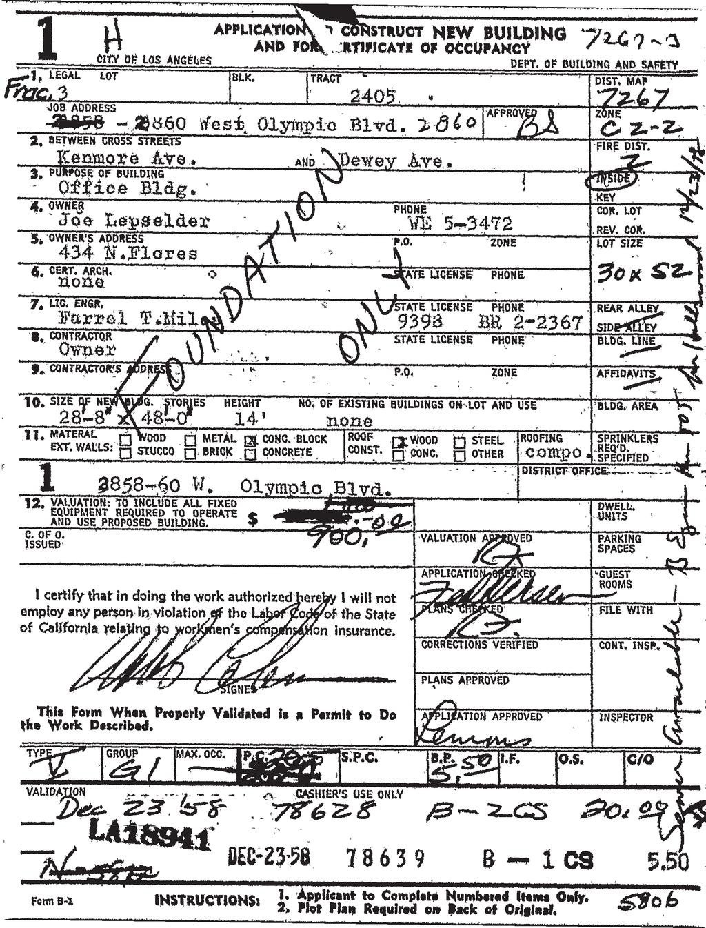
423
424

425

426

427

428

429
430

431
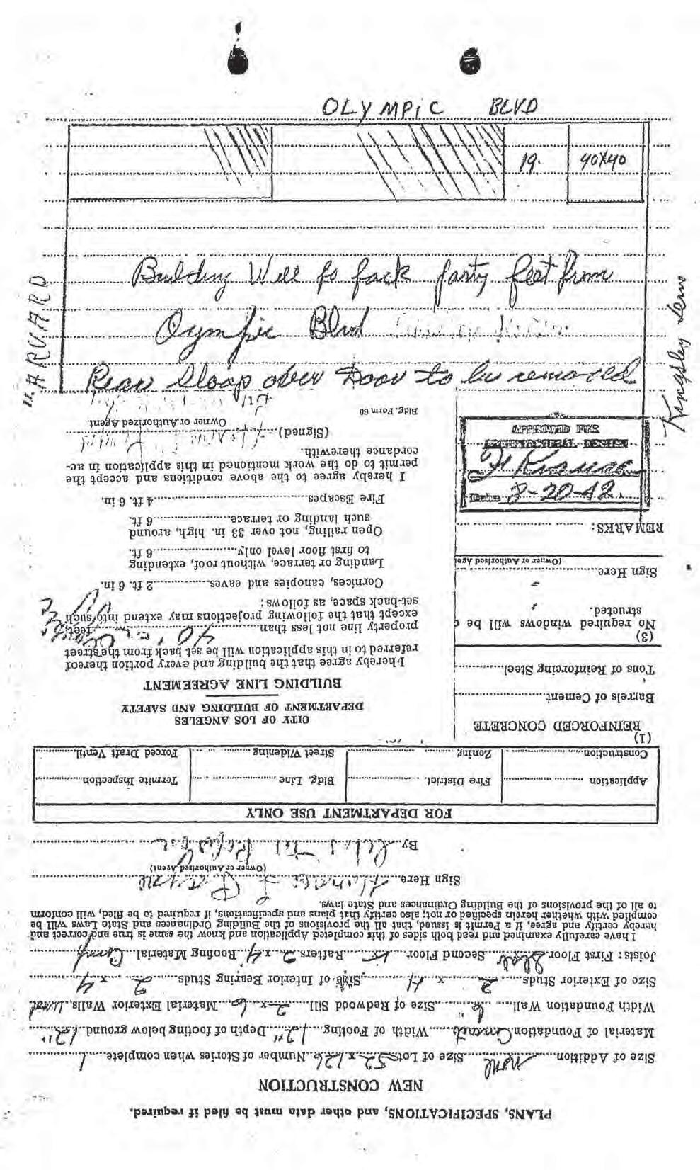
432

433
434

435

436

437
438

439

440

441
442

443

444
445
446
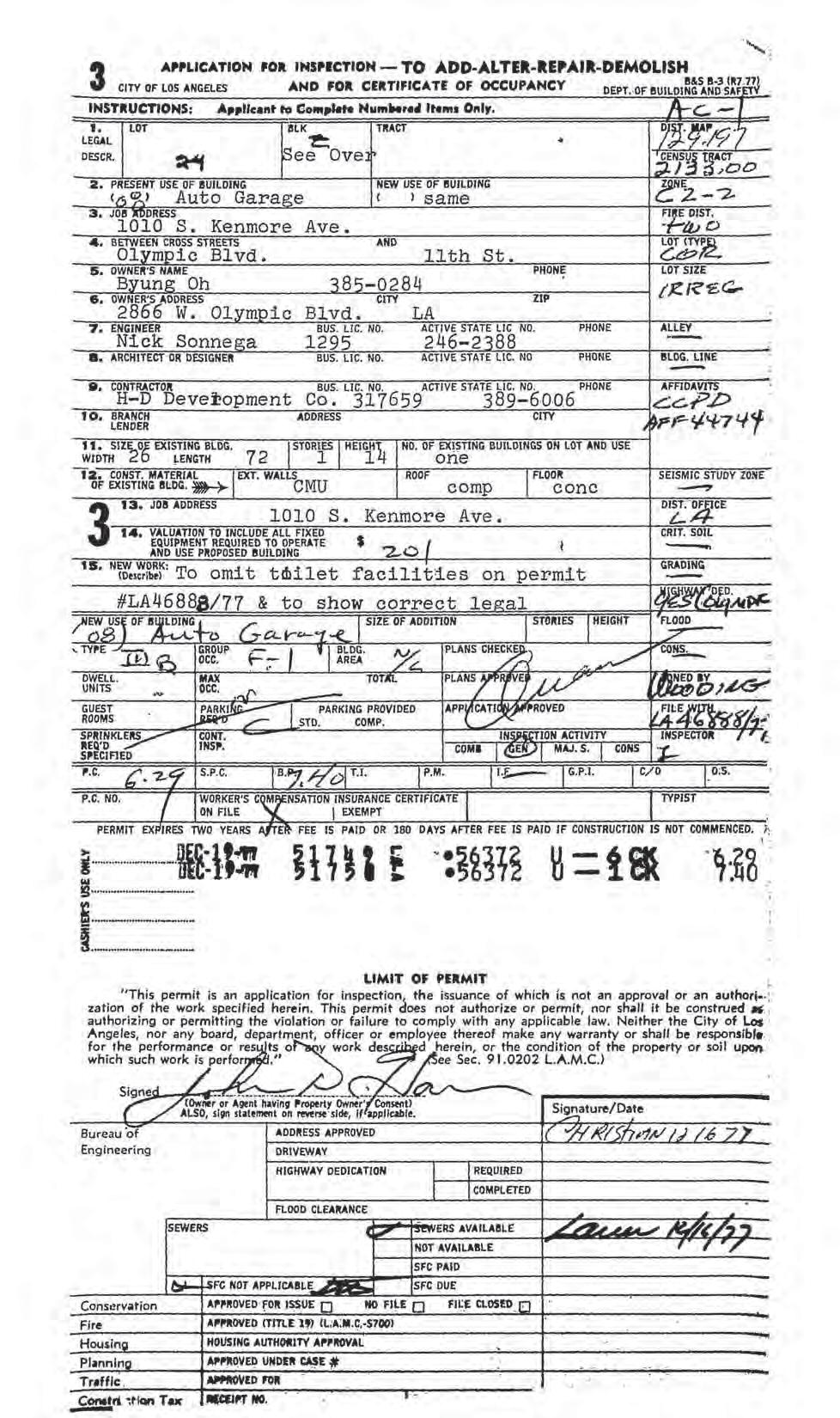
447
448
449

450
451
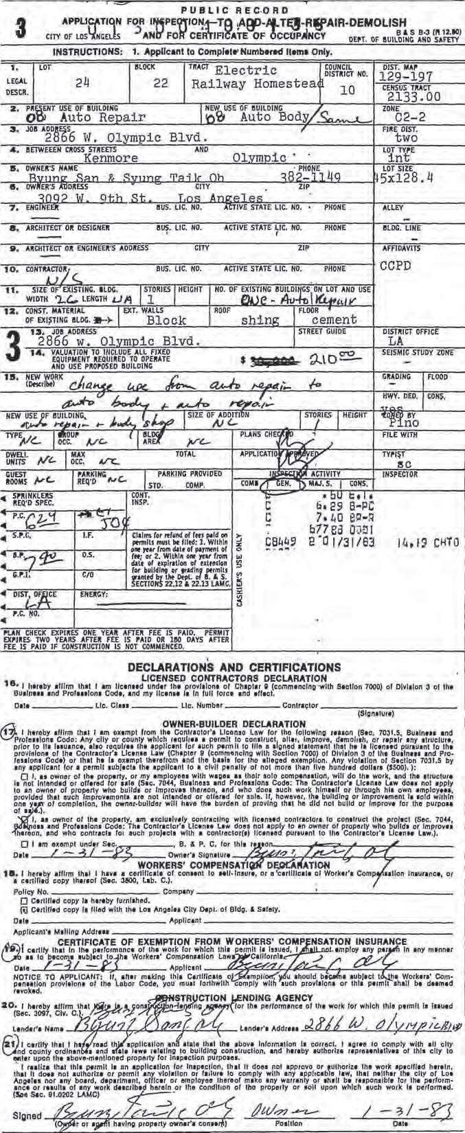
452

453
454

455

456

457
458
459 Environmental Site Assessment APPENDIX F QUALIFICATION OF ENVIRONMENTAL PROFESSIONAL / LIABILITY INSURANCE ENCON Solutions, Inc.
460
461

462
463
464
465

466