Update on ST3 West Seattle and Ballard Link Extensions
|
|
|
- Regina Leonard
- 5 years ago
- Views:
Transcription


1 Update on ST3 West Seattle and Ballard Link Extensions Level 2 Screening Results September 25, 2018 Item No. 7a_supp Date of Meeting September 25,
2 Primary Port of Seattle Objectives for ST3 Projects 1. Improve regional transportation for personal mobility, while protecting maritime and industrial land uses and freight mobility; 2. Strengthen access to POS/NWSA facilities, both existing and future developments; and 3. Enhance service to Seattle-Tacoma International Airport for passengers and employees, from a web of cities throughout the region. 2

3 System expansion Sound Transit s system expansion means every few years new light rail, bus rapid transit and commuter rail stations open throughout the region, providing fast, reliable alternatives to congested roads. soundtransit.org/system

4 ST3 Representative project Identifies mode, corridor, number of stations, general station locations Informs cost, schedule, operating needs 4

5 West Seattle Link Extension Opening 2030 Four elevated stations at SODO, Delridge, Avalon and Alaska Junction; one at-grade station at Stadium New rail-only fixed span crossing of the Duwamish River Length: 4.7 miles

6 Ballard Link Extension Opening 2035 Three elevated stations: Ballard, Interbay, Smith Cove Six tunnel stations: Seattle Center, South Lake Union, Denny, Westlake, Midtown, International District/Chinatown New rail-only movable bridge over Salmon Bay Length: 7.1 miles
7 West Seattle project timeline PLANNING DESIGN CONSTRUCTION START OF SERVICE 2016 Alternatives development Board identifies preferred alternative Draft Environmental Impact Statement Final Environmental Impact Statement Board selects project to be built Final route design Final station designs Procure and commission station and public art Obtain land use and construction permits Conversations with property owners Groundbreaking Construction updates and mitigation Safety education Testing and pre-operations 2030 Federal Record of Decision PUBLIC INVOLVEMENT PUBLIC INVOLVEMENT PUBLIC INVOLVEMENT

8 Ballard project timeline PLANNING DESIGN CONSTRUCTION START OF SERVICE 2016 Alternatives development Board identifies preferred alternative Draft Environmental Impact Statement Final Environmental Impact Statement Board selects project to be built Final route design Final station designs Procure and commission station and public art Obtain land use and construction permits Conversations with property owners Groundbreaking Construction updates and mitigation Safety education Testing and pre-operations 2035 Federal Record of Decision PUBLIC INVOLVEMENT PUBLIC INVOLVEMENT PUBLIC INVOLVEMENT
9 PLANNING DESIG Alternatives development Board identifies preferred alternative Draft Environmental Impact Statement Final Environmental Impact Statement Board selects project to be built Federal Record of Decision PUBLIC INVOLVEMENT


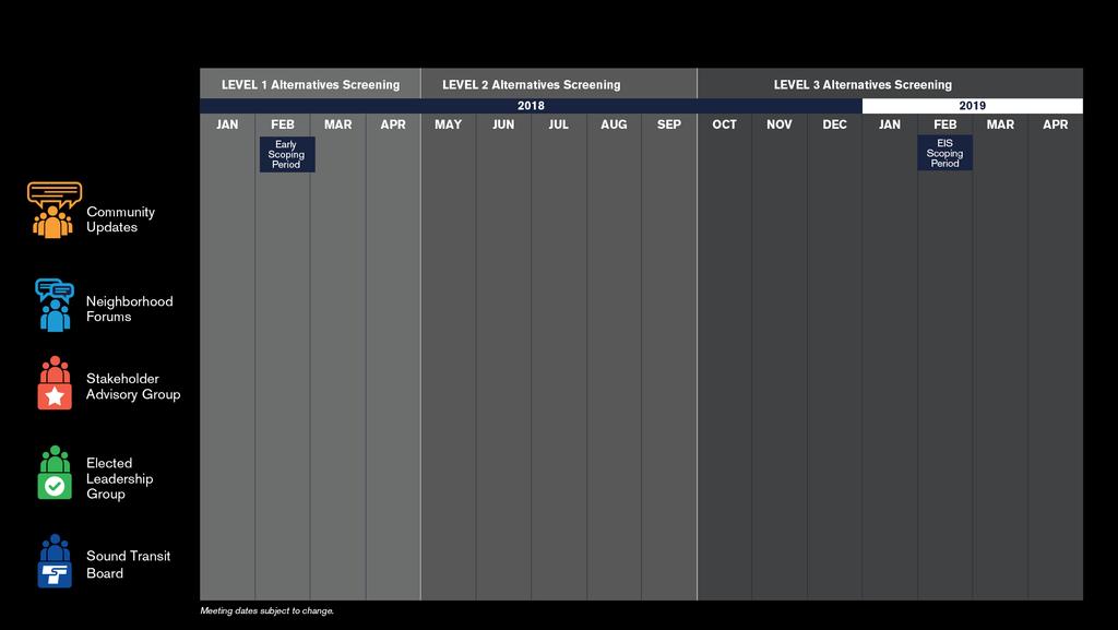
10 Alternatives development process LEVEL 1 Alternatives development LEVEL 2 Alternatives development LEVEL 3 Alternatives development PREFERRED ALTERNATIVE* Early-2018 Mid-2018 Late-2018 / Early-2019 Early-2019 Conduct early scoping Study ST3 representative project and alternatives Screen alternatives Technical analysis Refine and screen alternatives Refine and screen alternatives Conduct Environmental Impact Statement (EIS) scoping PUBLIC INVOLVEMENT PUBLIC INVOLVEMENT PUBLIC INVOLVEMENT *The Sound Transit Board identifies preferred alternatives and other alternatives to study.
11 Screening process Broad range of initial alternatives Refine remaining alternatives Further evaluation Preferred Alternative and other EIS alternatives 11

12 Community Engagement and Collaboration 12
13 Community engagement and collaboration 13


14 Overview Early scoping: Feb. 2 March 5 Notification via postcards, advertisements, project website, updates, press releases, social media, agency invitation letters, etc. 3 public meetings in Feb. Online open house 1 agency meeting Other methods to comment 14

15 Neighborhood forums 4/21: Chinatown / Int l District 4/23: Denny / SLU / Seattle Center 5/2: Midtown / Westlake 5/5: Delridge / Avalon / Alaska Junction 5/9: SODO / Stadium 5/12: Ballard / Interbay / Smith Cove 15
16 External Engagement Report: Jun-Aug comments and questions 8 festivals engaging more than 3,300 community members 6 updates engaging more than 4,000 subscribers 49 community briefings 4 Tweets engaging more than 82,000 users 2 Stakeholder Advisory Group meetings 5 posts engaging more than 30,000 users 1 Elected Leadership Group meeting 16

17 Station Charrettes Collaborative design sessions with agencies, key community stakeholders 6/28: Ballard / Interbay 7/12: Seattle Center 7/20: Delridge 7/24: Alaska Junction / Avalon 7/30: Chinatown International District 8/2: Denny / SLU 8/28 SODO/Stadium 17

18 Level 2 alternatives evaluation 18

19 Purpose and need Purpose Statement Symbol Provide high quality rapid, reliable, and efficient peak and off-peak LRT service to communities in the project corridors as defined in ST3. Improve regional mobility by increasing connectivity and capacity through downtown Seattle to meet the projected transit demand. Connect regional centers as described in adopted regional and local land use, transportation, and economic development plans and Sound Transit s Regional Transit Long-Range Plan. Implement a system that is consistent with the ST3 Plan that established transit mode, corridor, and station locations and that is technically feasible and financially sustainable to build, operate, and maintain. Expand mobility for the corridor and region s residents, which include transit dependent, low income, and minority populations. Encourage equitable and sustainable urban growth in station areas through support of transit-oriented development, station access, and modal integration in a manner that is consistent with local land use plans and policies. Preserve and promote a healthy environment and economy by minimizing adverse impacts on the natural, built and social environments through sustainable practices. 19
20 Evaluation criteria 17 criteria consistent in all levels of evaluation Reliable service Travel times Regional connectivity Transit capacity Projected transit demand Regional centers served ST Long-Range Plan consistency ST3 consistency Technical feasibility Financial sustainability Historically underserved populations Station area local land use plan consistency Modal integration Station area development opportunities Environmental effects Traffic operations Economic effects 20


21 Measures and methods 50+ quantitative and/or qualitative measures Rating thresholds for High, Medium and Low Key differentiators and findings Lower Performing Medium Performing Higher Performing 21
22 Cost assessment Purpose: To inform comparison of Level 2 alternatives Comparative costs by segment Consistent methodology (2017$; construction, real estate, etc.) Based on limited conceptual design (less than 5% design) Final project budget established at 60% design (~ 2024) Costs for end-to-end alternatives in Level 3 22
23 Financial constraints ST3 Plan budget based on 2014 conceptual cost estimates Significant recent escalation in construction and real estate costs Level 2 cost assessment provides basis for comparison of alternatives within a segment Level 3 end-to-end alternatives will facilitate comparison to ST3 budget Be mindful of financial realities when considering Level 2 recommendations 23

24 West Seattle/ Duwamish Interbay/Ballard SODO and Chinatown/ID Downtown Study segments 24


25 1 2 Map of alternatives Evaluation measures 3 4 Key differentiators Summary 25
26 Level 2 alternatives Interbay/Ballard ST3 Representative Project 15th/Fixed Bridge/15th 20th/Fixed Bridge/17th 20th/Tunnel/15th Armory Way/Tunnel/14th Central Interbay/Movable Bridge/14th Central Interbay/Fixed Bridge/14th Central Interbay/Tunnel/15th 26
27 Interbay/Ballard Level 2 alternatives 27
28 Evaluation Measures ST3 Representative Project 15th/Fixed Bridge/ 15th 20th/Fixed Bridge/ 17th Interbay/Ballard Level 2 alternatives evaluation Part 1 of 2 20th/Tunnel/ 15th Central Interbay/ Movable Bridge/ 14th Armory Way/ Tunnel/14th Central Interbay/ Fixed Bridge/14th Central Interbay/ Tunnel/15th Medium Medium Medium Medium Provide high quality rapid, reliable, and efficient peak and off-peak light rail transit service to communities in the project corridors defined in ST3. Potential Service Interruptions Lower Higher Higher Higher Lower Higher Higher Higher Travel Times (minutes) 5 to 6 5 to 6 5 to 6 5 to 6 5 to 6 5 to 6 5 to 6 5 to 6 Improve regional mobility by increasing connectivity and capacity through downtown Seattle to meet projected transit demand. Network Integration Medium Medium Medium Medium Medium Medium Medium Medium Passenger Carrying Capacity Medium Medium Medium Medium Medium Medium Medium Medium Ridership Potential (2040 pop/emp) (1) 17,200 16,700 19,000 17,800 15,400 16,400 15,400 16,500 Connect regional centers as described in adopted regional and local land use, transportation, and economic development plans and Sound Transit s Long-Range Plan. Regional Growth Centers Served N/A (3) N/A N/A N/A N/A N/A N/A N/A Manufacturing/Industrial Centers Served Accommodates Future LRT Extension Medium Medium Lower Higher Medium Higher Medium Higher Implement a system that is consistent with the ST3 Plan that established transit mode, corridor, and station locations and that is technically feasible and financially sustainable to build, operate, and maintain. Mode, Route and Stations per ST3 Higher Higher Higher Higher Higher Higher Higher Higher Potential ST3 Schedule Effects Higher Higher Higher Higher Higher Higher Higher Higher Potential ST3 Operating Plan Effects Lower Higher Higher Higher Lower Higher Higher Higher Engineering Constraints Medium Medium Medium Lower Higher Lower Higher Lower Constructability Issues Medium Medium Medium Lower Higher Lower Higher Lower Operational Constraints Lower Higher Higher Higher Lower Higher Higher Higher Conceptual Capital Cost Comparison - $200M increase $500M increase $700M increase $200M increase $300M increase $100M increase $500M increase Operating Cost Impacts Medium Medium Medium Medium Medium Medium Medium Medium Expand mobility for the corridor and region s residents, which include transit dependent, low income, and minority populations. Opportunities for Low-Income/Minority Medium Medium Medium Medium (activity nodes/subsidized rental units) (1) 8% 9% 8% 8% 8% 8% 8% 9% Low-Income Population (1/2) 19% / 18% 20% / 18% 20% / 18% 20% / 18% 19% / 18% 19% / 18% 19% / 18% 19% / 18% Minority Population (1/2) 21% / 20% 21% / 20% 21% / 20% 21% / 20% 21% / 20% 21% / 20% 21% / 20% 21% / 20% Youth Population (1/2) 9% / 12% 11% / 12% 11% / 12% 11% / 12% 12% / 12% 11% / 12% 12% / 12% 10% / 12% Elderly Population (1/2) 10% / 10% 10% / 10% 10% / 10% 10% / 10% 9% / 10% 9% / 10% 9% / 10% 10% / 10% Limited English Proficiency Population (1/2) 4% / 3% 4% / 3% 4% / 3% 4% / 3% 3% / 3% 3% / 3% 3% / 3% 3% / 3% Disabled Population (1/2) 9% / 8% 9% / 8% 9% / 8% 9% / 8% 8% / 8% 8% / 8% 8% / 8% 9% / 8% (1) Within station walksheds (2) Within 15 minute ride on connecting high frequency transit (3) NA = Measure not applicable to this segment Lower Performing Medium Performing Higher Performing 28
29 Evaluation Measures ST3 Representative Project 15th/Fixed Bridge/ 15th 20th/Fixed Bridge/ 17th 20th/Tunnel/ 15th Central Interbay/ Movable Bridge/ 14th Armory Way/ Tunnel/14th Central Interbay/ Fixed Bridge/14th Central Interbay/ Tunnel/15th Encourage equitable and sustainable urban growth in station areas through support of transit-oriented development, station access, and modal integration in a manner that is consistent with local land use plans and policies. Compatibility with Urban Centers/Villages (1) Medium Medium Medium Medium Lower Lower Lower Medium Station Land Use Plan Consistency Medium Medium Medium Medium Medium Medium Medium Medium Activity Nodes Served (1) Passenger Transfers Medium Medium Medium Medium Medium Medium Medium Medium Bus/Rail and Rail/Rail Integration (1) Higher Medium Medium Higher Higher Higher Higher Higher Bicycle Accessibility (1) Higher Higher Higher Higher Medium Higher Medium Higher Pedestrian/Limited Mobility Accessibility (1) Lower Medium Higher Higher Lower Medium Lower Medium Development Potential (1) Medium Medium Higher Medium Medium Medium Medium Medium Equitable Development Opportunities Lower Higher Lower Lower Medium Medium Medium Higher Preserve and promote a healthy environment and economy by minimizing adverse impacts on the natural, built and social environments through sustainable practices. Historic Properties/Landmarks (2) Potential for Effects to Archaeological Resources (1) Lower Lower Lower Lower Lower Lower Lower Lower Parks and Recreational Resources Effects (acres) Water Resource Effects (acres) Fish and Wildlife Habitat Effects (acres) Hazardous Material Sites (2) Visual Effects Medium Medium Medium Higher Medium Medium Medium Medium Noise and Vibration Sensitive Receivers (1) Higher Higher Lower Medium Higher Higher Higher Higher Potentially Affected Properties Medium Lower Lower Higher Higher Higher Higher Higher Residential Unit Displacements Higher Lower Lower Medium Medium Higher Medium Higher Square Feet of Business Displacements Medium Medium Medium Higher Medium Higher Medium Lower Construction Impacts Lower Medium Lower Medium Higher Higher Higher Medium Burden on Low-Income/Minority Higher Higher Higher Higher Higher Higher Higher Higher Traffic Circulation and Access Effects Lower Medium Medium Higher Medium Higher Medium Higher Effects on Existing Transportation Facilities Medium Higher Lower Medium Medium Higher Medium Medium Effects on Freight Movement Lower Medium Medium Medium Medium Higher Medium Higher Business and Commerce Effects Lower Lower Medium Higher Medium Higher Medium Medium (1) Within station walksheds and/or defined buffer of alignment (2) On properties that overlap with the project footprint Lower Performing Interbay/Ballard Level 2 alternatives evaluation Part 2 of 2 Medium Performing Higher Performing 29

30 Smith Cove-Interbay Salmon Bay Crossing Ballard Terminus Interbay/Ballard Key differentiators By sub-segment 30

31 Smith Cove-Interbay: Key differentiators Station location Traffic Engineering constraints Interbay/Ballard Key differentiators Smith Cove-Interbay 31
32 Key differentiators Smith Cove-Interbay Alternative ST3 Representative Project Key differentiators 15 th /Fixed Bridge/15 th Lessens traffic/freight effects (avoids 15 th Ave median) 20 th /Fixed Bridge/17 th 20 th /Tunnel/15 th Central Interbay/ Movable Bridge/14 th Armory Way/ Tunnel/14 th Central Interbay/ Fixed Bridge/14 th Central Interbay/ Tunnel/15 th Lessens traffic/freight effects (avoids 15 th Ave) Long span bridge (over BNSF tracks) adds complexity Lessens traffic/freight effects (avoids 15 th Ave) At-grade sections (along BNSF tracks) lessen complexity 32
")

33 Salmon Bay Crossing: Key differentiators Crossing location Crossing type Bridge (fixed or movable) Tunnel Freight movement Business/commerce effects Interbay/Ballard Key differentiators Salmon Bay Crossing 33
34 Key differentiators Salmon Bay Crossing Alternative ST3 Representative Project 15 th /Fixed Bridge/15 th Key differentiators Fewer columns in water than movable bridge Maritime business effects (Fishermen s Terminal) 20 th /Fixed Bridge/17 th Long-span fixed bridge avoids columns in water 20 th /Tunnel/15 th Central Interbay/ Movable Bridge/14 th Armory Way/ Tunnel/14 th Central Interbay/ Fixed Bridge/14 th Central Interbay/ Tunnel/15 th Longer tunnel, more constrained portal Includes tunnel; requires 3 rd Party funding Potential service interruptions Maritime business and potential vessel navigation effects Shorter tunnel, less constrained portal Includes tunnel; requires 3 rd Party funding Fewer columns in water than movable bridge Maritime business effects Shorter tunnel, less constrained portal Includes tunnel; requires 3 rd Party funding 34

35 Ballard Terminus: Key differentiators Ballard Station location Elevated or tunnel Interbay/Ballard Key differentiators Ballard Terminus 35
36 Key differentiators Ballard Terminus Alternative ST3 Representative Project 15 th /Fixed Bridge/15 th 20 th /Fixed Bridge/17 th 20 th /Tunnel/15 th Central Interbay/ Movable Bridge/14 th Armory Way/ Tunnel/14 th Central Interbay/ Fixed Bridge/14 th Central Interbay/ Tunnel/15 th Key differentiators Elevated guideway (west side 15 th Ave NW) affects more parcels More residential displacements Ballard terminus/crossing location affects more residences Closer to center of Urban Village Tunnel station (west side 15 th Ave NW) affects residences Deeper tunnel station (~120 ); adds complexity Affects fewer parcels (along 14 th Ave NW) Farther from center of Urban Village Shallower tunnel station (~70 ) Tunnel station (east side 15 th Ave NW) affects businesses Shallower tunnel station (~80 ) 36
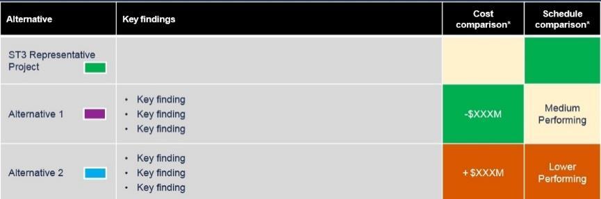
37 Summary Interbay/Ballard Alternative ST3 Representative Project Key findings Central Interbay/ Maritime business effects (but less than movable bridge) Fixed Bridge/14 th Affects fewer parcels in Ballard (along 14 th Ave NW) Potential service interruptions Central Interbay/ Maritime business and potential vessel navigation effects Movable Bridge/14 th Affects fewer parcels in Ballard (along 14 th Ave NW) 15 th /Fixed Bridge/15 th Maritime business effects (Fishermen s Terminal) Elevated guideway (west side 15 th Ave NW) affects more residences Less environmental, maritime business/navigation effects Armory Way/ Affects fewer parcels in Ballard (along 14 Tunnel/14 th th Ave NW) Includes tunnel; requires 3 rd Party funding Less environmental, maritime business/navigation effects Central Interbay/ Tunnel station (east side 15 Tunnel/15 th Ave NW) affects businesses th Includes tunnel; requires 3 rd Party funding 20 th /Fixed Bridge/17 th Long span bridge (over BNSF tracks) adds complexity Ballard terminus/crossing location affects more residences Long span bridge (over BNSF tracks), constrained tunnel portal location, deeper tunnel station add complexity 20 th /Tunnel/15 th Tunnel station (west side 15 th Ave NW) affects residences Includes tunnel; requires 3 rd Party funding Cost comparison* + $100M + $200M + $200M + $300M + $500M + $500M + $700M Schedule Comparison** Higher Performing Higher Performing Higher Performing Higher Performing Higher Performing Higher Performing Higher Performing *Cost compared to cost of ST3 Representative Project for this segment. Schedule compared to overall ST3 schedule for this extension. 37
38 Level 2 alternatives West Seattle/Duwamish ST3 Representative Project Pigeon Ridge/West Seattle Tunnel Oregon Street/Alaska Junction/Elevated Oregon Street/Alaska Junction/Tunnel (new) Golf Course/Alaska Junction/Tunnel (modified) 38
39 West Seattle/Duwamish Level 2 alternatives 39
40 Medium Medium Evaluation Measures ST3 Representative Project Pigeon Ridge/West Seattle Oregon Street/Alaska Junction/ Golf Course/Alaska Junction/ Oregon Street/Alaska Junction/ Tunnel Elevated Tunnel Tunnel Provide high quality rapid, reliable, and efficient peak and off-peak light rail transit service to communities in the project corridors defined in ST3. Potential Service Interruptions Higher Higher Higher Higher Higher Travel Times (minutes) 7 to 8 7 to 8 7 to 8 7 to 8 7 to 8 Improve regional mobility by increasing connectivity and capacity through downtown Seattle to meet projected transit demand. Network Integration Medium Medium Medium Medium Medium Passenger Carrying Capacity Medium Medium Medium Medium Medium Ridership Potential (2040 pop/emp) (1) 11,200 12,500 12,000 10,700 12,500 Connect regional centers as described in adopted regional and local land use, transportation, and economic development plans and Sound Transit s Long-Range Plan. Regional Growth Centers Served N/A (3) N/A N/A N/A N/A Manufacturing/Industrial Centers Served Accommodates Future LRT Extension Lower Medium Lower Higher Medium Implement a system that is consistent with the ST3 Plan that established transit mode, corridor, and station locations and that is technically feasible and financially sustainable to build, operate, and maintain. Mode, Route and Stations per ST3 Higher Higher Higher Medium Higher Potential ST3 Schedule Effects Higher Lower Higher Lower Lower Potential ST3 Operating Plan Effects Higher Higher Higher Higher Higher Engineering Constraints Medium Lower Medium Medium Higher Constructability Issues Lower Lower Lower Lower Medium Operational Constraints Medium Higher Medium Medium Medium Conceptual Capital Cost Comparison - $1,200M increase Similar $700M increase $500M increase Operating Cost Impacts Higher Medium Higher Medium Medium Expand mobility for the corridor and region s residents, which include transit dependent, low income, and minority populations. Opportunities for Low-Income/Minority Medium Medium Medium (activity nodes/subsidized rental units) (1) 15% 13% 14% 15% 13% Low-Income Population (1/2) 25% / 21% 24% / 21% 23% / 21% 26% / 21% 23% / 21% Minority Population (1/2) 22% / 26% 23% / 26% 21% / 26% 23% / 26% 21% / 26% Youth Population (1/2) 13% / 17% 14% / 17% 14% / 17% 13% / 17% 14% / 17% Elderly Population (1/2) 16% / 13% 15% / 13% 15% / 13% 16% / 13% 15% / 13% Limited English Proficiency Population (1/2) 3% / 4% 3% / 4% 3% / 4% 3% / 4% 3% / 4% Disabled Population (1/2) 9% / 9% 9% / 9% 9% / 9% 9% / 9% 9% / 9% (1) Within station walksheds (2) Within 15 minute ride on connecting high frequency transit (3) NA = Measure not applicable to this segment West Seattle/Duwamish Level 2 alternatives evaluation Part 1 of 2 Lower Performing Medium Performing Higher Performing 40
41 Evaluation Measures ST3 Representative Project Pigeon Ridge/West Seattle Oregon Street/Alaska Junction/ Golf Course/Alaska Junction/ Oregon Street/Alaska Junction/ Tunnel Elevated Tunnel Tunnel Encourage equitable and sustainable urban growth in station areas through support of transit-oriented development, station access, and modal integration in a manner that is consistent with local land use plans and policies. Compatibility with Urban Centers/Villages (1) Medium Medium Medium Medium Lower Station Land Use Plan Consistency Higher Higher Higher Higher Higher Activity Nodes Served (1) Passenger Transfers Medium Higher Medium Medium Higher Bus/Rail and Rail/Rail Integration (1) Medium Higher Medium Medium Higher Bicycle Accessibility (1) Higher Higher Higher Higher Higher Pedestrian/Limited Mobility Accessibility (1) Medium Higher Higher Higher Higher Development Potential (1) Medium Medium Medium Higher Medium Equitable Development Opportunities Lower Lower Medium Medium Higher Preserve and promote a healthy environment and economy by minimizing adverse impacts on the natural, built and social environments through sustainable practices. Historic Properties/Landmarks (2) Potential for effects to Archaeological Resources (1) Lower Lower Lower Lower Lower Parks and Recreational Resources Effects (acres) Water Resource Effects (acres) < 0.1 < 0.1 < 0.1 < 0.1 < 0.1 Fish and Wildlife Habitat Effects (acres) Hazardous Materials Sites (1) Visual Effects Lower Medium Lower Medium Medium Noise and Vibration Sensitive Receivers (1) Lower Lower Lower Medium Lower Potentially Affected Properties Higher Higher Lower Higher Lower Residential Unit Displacements Medium Lower Lower Higher Lower Square Feet of Business Displacements Higher Medium Lower Higher Medium Construction Impacts Lower Higher Lower Medium Medium Burden on Low-Income/Minority Higher Higher Higher Higher Higher Traffic Circulation and Access Effects Lower Higher Medium Higher Medium Effects on Existing Transportation Facilities Lower Higher Medium Medium Higher Effects on Freight Movement Medium Medium Medium Medium Lower Business and Commerce Effects Medium Higher Lower Medium Medium (1) Within station walksheds and/or defined buffer of alignment (2) On properties that overlap with the project footprint Lower Performing West Seattle/Duwamish Level 2 alternatives evaluation Part 2 of 2 Medium Performing Higher Performing 41


42 Avalon-Genesee- Delridge Duwamish Crossing Alaska Junction West Seattle/Duwamish Key differentiators By sub-segment 42


43 Duwamish Crossing: Key differentiators Crossing location Engineering constraints Fish and wildlife effects Freight movement West Seattle/Duwamish Key differentiators Duwamish Crossing 43
44 Key differentiators Duwamish Crossing Alternative ST3 Representative Project Key differentiators Pigeon Ridge / West Seattle Tunnel Bridge crossing near Idaho Street; south of Harbor Island Most engineering constraints (tunnel through unstable slopes, widest water crossing, wide Union Pacific Argo railyard crossing, high voltage lines etc.) Most effects to Duwamish Greenbelt Oregon Street / Alaska Junction / Elevated Golf Course / Alaska Junction / Tunnel Bridge crossing on south side of West Seattle bridge Some engineering constraints (Pigeon Point steep slope) Some effects to Duwamish Greenbelt (Pigeon Point) Oregon Street / Alaska Junction / Tunnel Bridge crossing on north side of West Seattle bridge Fewer engineering constraints (avoids Pigeon Point steep slope) Avoids effects to Duwamish Greenbelt Affects freight, port terminal facilities during construction 44
45 Summary West Seattle / Duwamish Alternative Key findings Cost comparison* Schedule comparison* ST3 Representative Project Oregon Street / Alaska Junction / Elevated 3 elevated stations Increases residential/business effects at Junction Complicates future extension south High guideway along Genesee Similar Higher Performing Oregon Street / Alaska Junction / Tunnel 1 tunnel station; 2 elevated stations High guideway along Genesee Fewer engineering constraints Affects freight, port terminal facilities during construction Includes tunnel; requires 3 rd Party funding + $500M Lower Performing Golf Course / Alaska Junction / Tunnel 2 tunnel stations; 1 elevated station Lessens residential/business effects at Junction Low guideway along Genesee Includes tunnel; requires 3 rd Party funding + $700M Lower Performing Pigeon Ridge / West Seattle Tunnel 2 tunnels; 2 tunnel stations; 1 elevated station Most engineering constraints Most effects to Duwamish Greenbelt Low guideway along Genesee Lessens residential and business effects in Delridge Includes two tunnels; requires 3 rd Party funding + $1,200M Lower Performing *Cost compared to cost of ST3 Representative Project for this segment. Schedule compared to overall ST3 schedule for this extension. 45
46 Level 2 alternatives SODO/Chinatown-ID ST3 Representative Project Massachusetts Tunnel Portal Surface E-3 4th Avenue Cut-and-Cover C-ID 4th Avenue Mined C-ID 5th Avenue Mined C-ID Occidental Avenue 46
47 ST3 Representative Project Massachusetts Tunnel Portal Surface E-3 SODO and Chinatown-ID Level 2 alternatives 1 of 3 47

48 4 th Avenue Cut-and-Cover C-ID 4 th Avenue Mined C-ID 5 th Avenue Mined C-ID SODO and Chinatown-ID Level 2 alternatives 2 of 3 48

49 Occidental Avenue SODO and Chinatown-ID Level 2 alternatives 3 of 3 49
50 Higher Higher Higher Evaluation Measures ST3 Representative Massachusetts Tunnel 4th Avenue Cut-and- Surface E-3 Project Portal Cover C-ID 4th Avenue Mined C-ID 5th Avenue Mined C-ID Occidental Avenue Provide high quality rapid, reliable, and efficient peak and off-peak light rail transit service to communities in the project corridors defined in ST3. Potential Service Interruptions Lower Medium Higher Lower Lower Medium Higher Travel Times (minutes) 3 to 4 3 to 4 3 to 4 3 to 4 3 to 4 3 to 4 3 to 4 Improve regional mobility by increasing connectivity and capacity through downtown Seattle to meet projected transit demand. Network Integration Medium Medium Higher Medium Medium Medium Medium Passenger Carrying Capacity Medium Medium Medium Medium Medium Medium Medium Ridership Potential (2040 pop/emp) (1) 35,900 35,900 35,900 35,300 35,300 35,900 37,100 Connect regional centers as described in adopted regional and local land use, transportation, and economic development plans and Sound Transit s Long-Range Plan. Regional Growth Centers Served N/A (3) N/A N/A N/A N/A N/A N/A Manufacturing/Industrial Centers Served Accommodates Future LRT Extension Medium Medium Medium Medium Medium Medium Medium Implement a system that is consistent with the ST3 Plan that established transit mode, corridor, and station locations and that is technically feasible and financially sustainable to build, operate, and maintain. Mode, Route and Stations per ST3 Higher Higher Higher Higher Higher Higher Medium Potential ST3 Schedule Effects Higher Higher Higher Lower Lower Medium Higher Potential ST3 Operating Plan Effects Medium Medium Higher Higher Lower Medium Higher Engineering Constraints Medium Medium Medium Lower Lower Medium Lower Constructability Issues Medium Medium Medium Lower Lower Medium Lower Operational Constraints Medium Medium Higher Medium Lower Medium Medium Conceptual Capital Cost Comparison - $200M decrease $400M decrease $600M increase $500M increase Similar Similar (+ $200M in SODO) Operating Cost Impacts Medium Medium Higher Medium Medium Medium Medium Expand mobility for the corridor and region s residents, which include transit dependent, low income, and minority populations. Opportunities for Low-Income/Minority Higher Higher Higher Higher (activity nodes/subsidized rental units) (1) 80% 80% 80% 75% 75% 80% 73% Low-Income Population (1/2) 59% / 49% 59% / 49% 59% / 49% 57% / 49% 57% / 49% 59% / 49% 58% / 49% Minority Population (1/2) 65% / 54% 65% / 54% 65% / 54% 63% / 54% 63% / 54% 65% / 54% 65% / 53% Youth Population (1/2) 7% / 7% 7% / 7% 7% / 7% 6% / 7% 6% / 7% 7% / 7% 7% / 8% Elderly Population (1/2) 20% / 19% 20% / 19% 20% / 19% 20% / 19% 20% / 19% 20% / 19% 20% / 19% Limited English Proficiency Population (1/2) 30% / 19% 30% / 19% 30% / 19% 28% / 19% 28% / 19% 30% / 19% 30% / 18% Disabled Population (1/2) 24% / 19% 24% / 19% 24% / 19% 25% / 19% 25% / 19% 24% / 19% 24% / 19% (1) Within station walksheds (2) Within 15 minute ride on connecting high frequency transit (3) NA = Measure not applicable to this segment SODO and Chinatown-ID Level 2 alternatives evaluation Part 1 of 2 Lower Performing Medium Performing Higher Performing 50
51 Evaluation Measures ST3 Representative Massachusetts Tunnel 4th Avenue Cut-and- Surface E-3 Project Portal Cover C-ID 4th Avenue Mined C-ID 5th Avenue Mined C-ID Occidental Avenue Encourage equitable and sustainable urban growth in station areas through support of transit-oriented development, station access, and modal integration in a manner that is consistent with local land use plans and policies. Compatibility with Urban Centers/Villages (1) Medium Medium Medium Medium Medium Medium Medium Station Land Use Plan Consistency Medium Medium Medium Medium Medium Medium Medium Activity Nodes Served (1) Passenger Transfers Higher Medium Medium Medium Lower Lower Medium Bus/Rail and Rail/Rail Integration (1) Medium Medium Medium Medium Medium Medium Medium Bicycle Accessibility (1) 21% 21% 21% 21% 21% 21% 21% Pedestrian/Limited Mobility Accessibility (1) Medium Medium Medium Medium Medium Medium Medium Development Potential (1) 14% 14% 14% 13% 13% 14% 15% Equitable Development Opportunities Lower Medium Lower Medium Lower Medium Higher Preserve and promote a healthy environment and economy by minimizing adverse impacts on the natural, built and social environments through sustainable practices. Historic Properties/Landmarks (2) Potential for effects to Archaeological Resources (1) Lower Lower Lower Lower Lower Lower Lower Parks and Recreational Resources Effects (acres) Water Resource Effects (acres) Fish and Wildlife Habitat Effects (acres) Hazardous Materials Sites (1) Visual Effects Higher Higher Higher Higher Higher Higher Higher Noise and Vibration Sensitive Receivers (1) Medium Medium Medium Medium Medium Medium Medium Potentially Affected Properties Medium Medium Medium Medium Medium Medium Medium Residential Unit Displacements Medium Medium Medium Medium Medium Medium Medium Square Feet of Business Displacements Higher Lower Higher Lower Higher Lower Lower Construction Impacts Lower Higher Medium Lower Lower Higher Medium Burden on Low-Income/Minority Medium Medium Medium Lower Lower Higher Medium Traffic Circulation and Access Effects Medium Higher Medium Lower Medium Higher Medium Effects on Existing Transportation Facilities Lower Higher Medium Lower Lower Higher Medium Effects on Freight Movement Medium Higher Medium Lower Lower Higher Lower Business and Commerce Effects Medium Medium Medium Medium Medium Higher Lower (1) Within station walksheds and/or defined buffer of alignment (2) On properties that overlap with the project footprint Lower Performing Medium Performing Higher Performing SODO and Chinatown-ID Level 2 alternatives evaluation Part 2 of 2 51


52 SODO Chinatown-ID SODO and Chinatown-ID Key differentiators By sub-segment 52
53 Summary SODO Alternative ST3 Representative Project Key findings Cost comparison* Schedule comparison* Surface E-3 Massachusetts Tunnel Portal New at-grade SODO Station on E-3 transitway at Lander Transfer at existing SODO Station Bus operations on E-3 transitway displaced New grade-separated roadway crossings (Lander, Holgate) improve existing rail/traffic/freight operations Property effects at tunnel portal site (for Massachusetts Tunnel Portal alternative only) Massachusetts Tunnel Portal alternative avoids impacts to Ryerson Base - $100M ** Higher Performing Higher Performing Occidental Ave. New elevated SODO Station on Occidental Ave at Lander Transfer at existing Stadium Station Long span bridges over BNSF tracks and longer track connection to maintenance facility Bus operations on E-3 transitway partially displaced Property effects along Occidental, BNSF crossings and maintenance facility connection + $200M Higher Performing *Cost compared to cost of ST3 Representative Project for this SODO sub-segment only. Schedule compared to overall ST3 schedule for this extension. **Cost comparison reflected in Chinatown/ID summary table. 53
54 Summary Chinatown-ID Alternative Key findings Cost comparison* Schedule comparison* ST3 Representative Project E-3 Surface (shorter 5 th Ave Cut-and- Cover Tunnel) Shallow cut-and-cover station under 5 th Ave; easy rider access/transfers Construction effects, lane closures on 5 th Ave in station area - $300M** Higher Performing Massachusetts Tunnel Portal (5 th Ave Bored Tunnel) Shallow cut-and-cover station under 5 th Ave; easy rider access/transfers Construction effects, lane closures on 5 th Ave in station area - $200M Higher Performing 5 th Ave Mined C-ID Deep mined station (~200 ) under 5 th Ave; poor rider access/transfers Less construction effects, lane closures on 5 th Ave with mined station Some property effects (for mined station access shaft) Results in very deep Midtown Station (~250 ) Similar Medium Performing 4 th Ave Mined C-ID Deep mined station (~200 ) under 4 th Ave, poor rider access/transfers Major engineering/constructability constraints (4 th Ave viaduct demolition/rebuild, active BNSF railway, existing transit tunnel, etc.) Large property effects (Ryerson Base for tunnel portal site) Requires 3 rd party funding of 4 th Ave Viaduct re-build costs Results in very deep Midtown Station (~250 ) + $500M Lower Performing 4 th Ave Cut-and-Cover C-ID Shallow cut-and-cover station under 4 th Ave; easy rider access/transfers Major engineering/constructability constraints (4 th Ave viaduct demolition/rebuild, active BNSF railway, existing transit tunnel, etc.) Large property effects (King County Admin Building) Requires 3 rd party funding of 4 th Ave Viaduct re-build costs + $600M Lower Performing *Cost compared to cost of ST3 Representative Project for this segment. Schedule compared to overall ST3 schedule for this extension. **Cost comparison for Chinatown/ID sub-segment only; total SODO/C-ID segment cost difference is - $400M compared to ST3 Representative Project. 54
55 Key POS, NWSA Evaluation Criteria and Measures Economic Effects Freight movement and access on land and water Business and commerce effects Regional Mobility Transit connectivity Ridership demand Transportation Operations Traffic circulation and access Transportation facilities Environmental Effects Water resources Property acquisitions and displacements Construction impacts Possible impacts to operations and facilities 55


56 Homeport to the Alaska fishing fleet & a vibrant commercial destination 6,419 Local jobs and $449 million in business revenue


57 Terminal 91 Blends fishing and cruise operations throughout the year Cruise ship homeport generates $2.7 million and provides over 4,000 jobs


58 International Container Trade Marine cargo operations provides $379 million in state and local taxes Nearly $4.3 billion in economic activity and more than 48,000 jobs 58
59 Key Dates Stakeholder Advisory Group Level 2 recommendations September 26 Elected Leadership Group (ELG) Level 2 recommendations October 5 EIS scoping period February 2019 SEPA process expected ELG preferred alternative recommendation March 22, 2019 ST Board identification of preferred alternative April
West Seattle and Ballard Link Extensions. Level 2 Evaluation Results September 2018
 West Seattle and Ballard Link Extensions Level 2 Evaluation Results September 2018 Agenda Introductions and purpose Community engagement update Alternatives development overview Level 2 alternatives evaluation
West Seattle and Ballard Link Extensions. Stakeholder Advisory Group March 14, 2018
 West Seattle and Ballard Link Extensions Stakeholder Advisory Group March 14, 2018 Agenda Introductions What we heard during early scoping Alternatives evaluation framework Neighborhood Forums Next steps
West Seattle and Ballard Link Extensions. Stakeholder Advisory Group January 9, 2019
 West Seattle and Ballard Link Extensions Stakeholder Advisory Group January 9, 2019 Agenda Welcome and introductions Community engagement & collaboration Level 3 screening process and beyond Level 3 end-to-end
West Seattle and Ballard Link Extensions Stakeholder Advisory Group Meeting #8 September 5, 2018 Meeting Notes
 West Seattle and Ballard Link Extensions Stakeholder Advisory Group Meeting #8 September 5, 2018 Meeting Notes Agenda Item #1 Welcome and introductions Diane Adams, Facilitator, welcomed Stakeholder Advisory
C-01c: Downtown Seattle to Ballard (Market Street vicinity) LRT, primarily elevated/tunnel options
 LRT, primarily elevated/tunnel options") Project Number C-01c Subarea North King Primary Mode Light Rail Facility Type Corridor Length 7.5 miles Version Number ST Board Workshop Date Last Modified 11-25-2015 PROJECT AREA AND REPRESENTATIVE ALIGNMENT
Project Number C-01c Subarea North King Primary Mode Light Rail Facility Type Corridor Length 7.5 miles Version Number ST Board Workshop Date Last Modified 11-25-2015 PROJECT AREA AND REPRESENTATIVE ALIGNMENT
Early Scoping Summary Report
 Early Scoping Summary Report April 2018 Summary West Seattle and Ballard Link Extensions Purpose Sound Transit conducted early scoping for the West Seattle and Ballard Link Extensions (WSBLE) Project in
West Seattle and Ballard Link Extensions Stakeholder Advisory Group Meeting #3 April 17, 2018 Meeting Notes. Agenda Item #1 Welcome and introductions
 West Seattle and Ballard Link Extensions Stakeholder Advisory Group Meeting #3 April 17, 2018 Meeting Notes Agenda Item #1 Welcome and introductions Diane Adams, Facilitator, welcomed the Stakeholder Advisory
Ballard-Interbay MIC Summary Statistics
 BallardInterbay MIC Founded in 1869, the City of Seattle is the leading commercial, cultural and advanced technology center of the U.S. Pacific Northwest, and a major port city for transpacific and European
South Sounder Capital Improvements Program
 Subarea South King/Pierce Primary Mode Commuter Rail Facility Type Infrastructure Improvement Length Date Last Modified July 1, 2016 PROJECT AREA AND REP RESENTATIVE ALIGNMENT SHORT PROJECT DESCRIPTION
SOUTHWEST LRT (METRO GREEN LINE EXTENSION)
") 8 Evaluation of Alternatives This chapter evaluates the effectiveness of the No Build Alternative and the Southwest Light Rail Transit (LRT) Project (the Project) based on the information contained in
8 Evaluation of Alternatives This chapter evaluates the effectiveness of the No Build Alternative and the Southwest Light Rail Transit (LRT) Project (the Project) based on the information contained in
Item No.: 5A Attachment Date of Meeting: April 3, March 5, 2018
 Item No.: 5A Attachment Date of Meeting: April 3, 2018 Board Chair Dave Somers West Seattle and Ballard Link Extensions Sound Transit 401 S. Jackson Street Seattle, WA 98104 VIA EMAIL: wsblink@soundtransit.org
Federal Way Transit Center to Tacoma Dome Light Rail
 Subarea South King/Pierce Primary Mode Light Rail Facility Type Corridor Length 9.7 miles Date Last Modified July 1, 2016 PROJECT AREA AND REPRESENTATIVE ALIGNMENT SHORT PROJECT DESCRIPTION This project
12 Evaluation of Alternatives
 12 Evaluation of Alternatives This chapter evaluates the effectiveness of the No-Build Alternative and the proposed METRO Blue Line Light Rail Transit (BLRT) Extension project based on the information
Environmental Scoping Information Report
 LINK OPERATIONS AND MAINTENANCE SATELLITE FACILITY Environmental Scoping Information Report CENTRAL PUGET SOUND REGIONAL TRANSIT AUTHORITY This page intentionally left blank Table of Contents Introduction...
West Seattle and Ballard Link Extensions Agenda Item #1 Welcome and introductions
 West Seattle and Ballard Link Extensions Stakeholder Advisory Group Meeting #2 March 14, 2018 Meeting Summary Agenda Item #1 Welcome and introductions Diane Adams, Facilitator, welcomed the Stakeholder
Lynnwood Link Extension 2013 Draft EIS Comments and Responses. Page 945
 I-441-001 Thank you for your comments about the importance of the Latvian Center to the Latvian community. Following the Draft EIS, the Sound Transit Board directed Sound Transit to develop a Preferred
APPENDIX N East King County Subarea High Capacity Transit (HCT) Analysis: Approach to Assessing System-Level Alternatives
 Analysis: Approach to Assessing System-Level Alternatives") Sound Transit Regional Transit Long-Range Plan Draft Supplemental Environmental Impact Statement APPENDIX N East King County Subarea High Capacity Transit (HCT) Analysis: Approach to Assessing System-Level
Sound Transit Regional Transit Long-Range Plan Draft Supplemental Environmental Impact Statement APPENDIX N East King County Subarea High Capacity Transit (HCT) Analysis: Approach to Assessing System-Level
S-09: Auburn Station Access Improvements
 Project Number S-09 Subarea South King Primary Mode Commuter Rail Facility Type Infrastructure Improvements Length Version Number ST Board Workshop Date Last Modified 11-25-2015 PROJECT AREA AND REPRESENTATIVE
Chapter 5 Transportation Draft
 Chapter 5 Transportation Draft Discussion Similar to the other elements in the Comprehensive Plan, the transportation element impacts the quality of life, economic development and public safety of the
South Sounder Capital Improvements Program
 South Sounder Capital Improvements Program Subarea South King/Pierce Primary Mode Commuter Rail Facility Type Infrastructure Improvement Length Version Draft ST3 Plan Date Last Modified March 28, 2016

FINAL. Sound Transit Long-Range Plan Update Issue Paper S.6: Potential Tacoma Link Extension - East. Prepared for: Sound Transit
 Sound Transit Long-Range Plan Update Issue Paper S.6: Potential Tacoma Link Extension - East Prepared for: Sound Transit Prepared by: Parsons Brinckerhoff Quade & Douglas, Inc. FINAL March 2005 Foreword
Sound Transit University Link Title VI Service and Fare Equity Analysis. March 14, 2016
 Sound Transit University Link Title VI Service and Fare Equity Analysis March 14, 2016 Table of Contents 1 Introduction... 1 1.1 The central Puget Sound transit environment... 1 1.2 Link light rail and
C-11: Madison Street BRT
 Project Number C-11 Subarea North King Primary Mode BRT Facility Type Corridor Length 2.3 miles Version ST Board Workshop Date Last Modified 11-25-2015 PROJECT AREA AND REPRESENTATIVE ALIGNMENT SHORT PROJECT
Locally Preferred Alternative. Work In Progress; Subject To Change Without Notice 1
 Locally Preferred Alternative 1 Riverview Corridor Study Area 12 mile study area between Saint Paul and Bloomington. Connects major destinations, neighborhoods and job concentrations. Serves growing and
S-16: Sounder Rail Extension from Puyallup to Orting
 Project Number S-16 Subarea Pierce Primary Mode Commuter Rail Facility Type Corridor Length 5.7 miles Version ST Board Workshop Date Last Modified 11-25-2015 PROJECT AREA AND REPRESENTATIVE ALIGNMENT SHORT
Light Rail Operations and Maintenance Facilities
 Subarea All Primary Mode Light Rail Facility Type Length Date Last Modified July 1, 2016 PROJECT AREA AND REPRESENTATIVE ALIGNMENT SHORT PROJECT DESCRIPTION This project would construct two new light rail
3 Documentation of Alternatives
 Sacramento Intermodal Transportation Facility TR #9 SITF Alternatives 3 Documentation of Alternatives This section documents the four alternative concept plans for the Sacramento Intermodal Transportation
11 Joint Development Regulatory Context and Methodology
 11 Joint Development This chapter describes the long-term direct and potential indirect impacts, and short-term direct and potential indirect impacts, of the proposed METRO Blue Line Light Rail Transit
Lynnwood Link Extension 2013 Draft EIS Comments and Responses. Page 275
 C-034-001 Thank you for your comments describing the cultural importance of the Latvian Evangelical Lutheran Church. See Section 2.5.1 for a description of the refined Segment A alternatives that avoid
PROLOGIS GEORGETOWN CROSSROADS
 PROLOGIS GEORGETOWN CROSSROADS 6050 EAST MARGINAL WAY SOUTH SEATTLE, WA THE FUTURE OF URBAN INDUSTRIAL REAL ESTATE 589,615 SF A REVOLUTIONARY MULTISTORY DEVELOPMENT MINUTES TO ANYWHERE PLANNED DESIGN Building
Appendix C Presentation Slides with Script
 Appendix C Presentation Slides with Script 32 Grand Crossing Rail Project 10 S. Riverside Plaza, Suite 400 Chicago, IL 60606 www.grandcrossingrail.com info@grandcrossingrail.com [title slide no narration]
EVALUATION OF ALTERNATIVES CARRIED FORWARD
 1 EVALUATION OF ALTERNATIVES CARRIED FORWARD This chapter presents a comparative evaluation of the alternatives carried forward in this Final Environmental Impact Statement (EIS). The intent of this evaluation
Gateway Corridor Transitway
 Locally Preferred Alternative Summary Gateway Corridor Transitway 1 Metropolitan Council, Nov. 12, 2014 Gateway Corridor Transitway Proposed highcapacity transit improvement connecting east metro suburbs
Chapter 5 - Transportation
 Chapter 5 - Transportation Discussion Similar to the other elements in the Comprehensive Plan, the transportation element impacts the quality of life, economic development and public safety of the residents
GULF COAST RAIL DISTRICT VISION FOR REGIONAL RAIL
 GULF COAST RAIL DISTRICT VISION FOR REGIONAL RAIL OCTOBER 2014 Cover photographs courtesy of Top left - Mike Bates TABLE OF CONTENTS MISSION... 1 INTRODUCTION... 1 VISION STATEMENT... 1 BACKGROUND... 2
Evaluation of Alternatives
 Chapter 9.0 Evaluation of Alternatives Chapter 9.0 provides a summary evaluation of the No Build Alternative and the Preferred Alternative. The evaluation contained within this chapter is an assessment
Transit Oriented Development Study
 Federal Way Link Extension Transit Oriented Development Study Table of Contents Executive Summary ES 1 Chapter 1: Introduction.. 1-1 Chapter 2: Methodology. 2-1 Chapter 3: Project Overview 3-1 Chapter
WELCOME EAST LINK OVERLAKE MASTER PLANNED DEVELOPMENT
 WELCOME The purpose of tonight s meeting is to: Educate the Overlake community about why Sound Transit is applying for a Master Planned Development Permit to build East Link within the City of Redmond
Sounder Extension to DuPont
 Subarea Pierce Primary Mode Commuter Rail Facility Type Station Length 7.8 miles Version Draft ST3 Plan Date Last Modified March 28, 2016 PROJECT AREA AND REPRESENTATIVE ALIGNMENT SHORT PROJECT DESCRIPTION
Mega Projects at WSDOT
 Mega Projects at WSDOT Managing multiple projects in major urban corridors LINEA LAIRD, WSDOT ASSISTANT SECRETARY ENGINEERING & OPERATIONS Presentation to Oregon State Legislature Congestion Work Group
Southwest Corridor Plan Project Update. June 11, 2013
 Southwest Corridor Plan Project Update June 11, 2013 The Southwest Corridor Collaborative effort Major Timeline Objectives Accountability and partnership Manage resources responsibly, foster collaborative
Midtown Corridor Alternatives Analysis. Technical Advisory Committee Meeting November 15, 2012
 Midtown Corridor Alternatives Analysis Technical Advisory Committee Meeting November 15, 2012 Today s Agenda Introductions Roles and Responsibilities Alternatives Analysis Process Overview Outreach Overview
Chicago Transit Authority Orange Line Alternatives Analysis Study
 Chicago Transit Authority July 10, 2009 Written questions and comments regarding the were submitted by a variety of individuals and groups from throughout the Chicago region at the study s Screen 2 Public
Chapter 4: Transportation and Land Use
 Chapter 4: Transportation and Land Use Transportation and land use together make possible the wide range of destination opportunities in the region. Transportation provides the connections, and, in turn,
ACTIVE TRANSPORTATION ADVISORY COMMITTEE. Memphis MPO March 30, 2015
 ACTIVE TRANSPORTATION ADVISORY COMMITTEE Memphis MPO March 30, 2015 Agenda Welcome & Introductions Announcements and Briefings Livability 2040: Regional Transportation Plan Congestion Management Process
PROLOGIS GEORGETOWN CROSSROADS
 PROLOGIS CROSSROADS 600 EAST MARGINAL WAY SOUTH SEATTLE, WA 89,61 SF THE FUTURE OF URBAN INDUSTRIAL REAL ESTATE www.prologisgeorgetown.com PLANNED DESIGN Redmond 40 20 Downtown Seattle Bellevue 90 Port
Sound Transit Long-Range Plan Update/SEIS Agency Scoping Meeting. November 8, 2013
 Sound Transit Long-Range Plan Update/SEIS Agency Scoping Meeting November 8, 2013 1 Agency Scoping Meeting for the Long- Range Plan (LRP) Update/Supplemental Environment Impact Statement (SEIS) Introductions
Prologis Georgetown Crossroads
 Prologis Georgetown Crossroads 600 East Marginal Way South Seattle, WA 89,61 SF The future of urban industrial real estate www.prologisgeorgetown.com Planned design Redmond 20 40 Downtown Seattle Bellevue
Assessment of Current Status, Plans, and Preliminary Alternatives for High Capacity Transportation in the I-5 Corridor
 CONNECTING THURSTON COUNTY AND THE CENTRAL PUGET SOUND Alternatives to Meet Transportation Needs in the I-5 Corridor Working Paper #1 June 2011 Assessment of Current Status, Plans, and Preliminary Alternatives
Restoration of Historic Streetcar Service in Downtown Los Angeles. Executive Summary -- Alternatives Analysis (AA) FINAL
 FINAL") Restoration of Historic Streetcar Service in Downtown Los Angeles Executive Summary -- Alternatives Analysis (AA) FINAL January 13, 2012 This page intentionally left blank Table of Contents S1.0 PURPOSE
Restoration of Historic Streetcar Service in Downtown Los Angeles Executive Summary -- Alternatives Analysis (AA) FINAL January 13, 2012 This page intentionally left blank Table of Contents S1.0 PURPOSE
Table of Contents. Green Line Extension Project. Draft Environmental Impact Report/Environmental Assessment and Draft Section 4(f) Evaluation
 Evaluation") Table of Contents Acronyms and Abbreviations Secretary s Certificate on the EENF Executive Summary 1 Introduction and Background... 1-1 1.1 Introduction... 1-1 1.2 Project Summary... 1-2 1.3 Permits and
Table of Contents Acronyms and Abbreviations Secretary s Certificate on the EENF Executive Summary 1 Introduction and Background... 1-1 1.1 Introduction... 1-1 1.2 Project Summary... 1-2 1.3 Permits and
TRANSPORTATION RELATIONSHIP TO OTHER ELEMENTS OF THE PLAN AND COUNTY REGULATIONS VISION FOR TRANSPORTATION PLANNING ROAD NETWORK SECTION 7
 TRANSPORTATION Like many growing western counties, Douglas County focuses on one of the most integral elements in land-use planning: transportation. The primary purpose of a transportation network is to
Bus Rapid Transit Project Update
 Bus Rapid Transit Project Update Woodinville City Council September 12, 2017 Sound Transit BRT Project Team Kamuron Gurol and Bernard van de Kamp: HCT Corridor Development Directors - kamuron.gurol@soundtransit.org,
2040 Transportation Policy Plan Conversion to Performance Based Planning Basis. 25 th Annual CTS Transportation Research Conference May 21, 2014
 2040 Transportation Policy Plan Conversion to Performance Based Planning Basis 25 th Annual CTS Transportation Research Conference May 21, 2014 1 About the plan Long-range transportation plan for the Twin
Preliminary Alternatives Analysis Community Workshop Palo Alto, April 27, 2010 Small Group Activity Summary
 Preliminary Alternatives Analysis Community Workshop Palo Alto, April 27, 2010 Small Group Activity Summary The following are the summary notes from the small break out groups. An overall summary of feedback
Frequently Asked Questions Connecting Palo Alto
 Frequently Asked Questions Connecting Palo Alto www.cityofpaloalto.org/connectingpaloalto General Project Questions Q1: What is Connecting Palo Alto? A1: Connecting Palo Alto (formerly the Palo Alto Rail
Proposed Council Changes to Comprehensive Plan
 Chapter 6 Transportation Page and line numbers reflect Planning Commission Recommended Draft dated 1/14/16 (http://wawhatcomcounty.civicplus.com/documentcenter/view/15155 ). To improve clarity of Councilmember
Vanasse Hangen Brustlin, Inc. DRAFT. Appendices. MIS Appendices
 DRFT ppendices MIS 8-05 - ppendices ppendices ugust 005 [THIS PGE INTENTIONLLY LEFT BLNK] DRFT ppendix Tier Detailed Evaluation Tables MIS 8-05 - ppendix ppendix ugust 005 [THIS PGE INTENTIONLLY LEFT BLNK]
POLK COUNTY TPO Polk County 2060 Transportation Vision Plan Final Report. ADOPTED June 18, 2009
 POLK COUNTY TPO Polk County 2060 Transportation Vision Plan Final Report ADOPTED June 18, 2009 TABLE OF CONTENTS CHAPTER 1 Introduction and Prior Planning Effort...Page 1-1 CHAPTER 2 Population and Employment
DRAFT ENVIRONMENTAL IMPACT STATEMENT FOR HOUSTON DALLAS HIGH SPEED RAIL (TEXAS CENTRAL)
") DRAFT ENVIRONMENTAL IMPACT STATEMENT FOR HOUSTON DALLAS HIGH SPEED RAIL (TEXAS CENTRAL) Background On June 25, 2014, the Federal Railroad Administration (FRA) issued a Notice of Intent to Prepare an Environmental
DRAFT ENVIRONMENTAL IMPACT STATEMENT FOR HOUSTON DALLAS HIGH SPEED RAIL (TEXAS CENTRAL) Background On June 25, 2014, the Federal Railroad Administration (FRA) issued a Notice of Intent to Prepare an Environmental
METROPOLITAN PLANNING ORGANIZATION FOR THE MIAMI URBANIZED AREA BLOCKS RIBBONS EXERCISE
 BLOCKS RIBBONS EXERCISE Welcome and thank you for making the decision to take part in the Miami-Dade Long Range Transportation Plan (LRTP) planning process. Based on forecasts from the Miami-Dade County
The Challenge: Joint Urban Freight Planning in Seattle
 The Challenge: Joint Urban Freight Planning in Seattle INUF October 10, 2013 Christine Wolf Outline Port Background Past Planning Efforts Current Planning Efforts City of Seattle Port of Seattle Continuing
Peninsula Corridor Electrification Project. Draft Environmental Impact Report
 Peninsula Corridor Electrification Project Draft Environmental Impact Report Public Meeting Purpose of Tonight s Meeting Provide an overview of Draft Environmental Impact Report (Draft EIR) Receive comments,
What is the Transportation Policy Plan (TPP)?
?") Summary What is the Transportation Policy Plan (TPP)? The region s long range transportation plan Includes all modes of transportation: highways, transit, airports, freight, biking, pedestrians Meets the
Summary What is the Transportation Policy Plan (TPP)? The region s long range transportation plan Includes all modes of transportation: highways, transit, airports, freight, biking, pedestrians Meets the
Chapter 4. Recommendations
 Chapter 4 Recommendations Project Rating Methodology 1.0 Introduction This chapter outlines the prioritization of potential investments that were identified during this MIS process. During this study there
2. Goals and Objectives
 Pedestrians in Charlotte s busy Uptown. CRTPO Mission The mission of the Charlotte Regional Transportation Planning Organization (CRTPO) is to plan for transportation options that ensure mobility, respect
1.1 Purpose of the Project
 Chapter 1 Purpose and Need for East Link Project 1.1 Purpose of the Project The purpose of the East Link Project is to expand the Sound Transit Link light rail system from Seattle to Mercer Island, Bellevue
Sound Transit is updating its Regional Transit Long-Range Plan, which
 Final Supplemental Environmental Impact Statement EXECUTIVE SUMMARY INTRODUCTION Sound Transit is updating its Regional Transit Long-Range Plan, which outlines the agency s vision for a high-capacity transit
Downtown Bellevue Station
 Downtown Bellevue Station Downtown Tunnel at 110th Ave. E E 2 nd Pl Summit Station Entry Abella Skyline Tower City Hall Station Entry City Center Plaza BTC E 6 nd St Bravern Provides a cut-andcover tunnel
West Santa Ana Branch Transit Corridor. Draft EIS/EIR Scoping Meeting June 2017
 West Santa Ana Branch Transit Corridor Draft EIS/EIR Scoping Meeting June 2017 Agenda > Welcome and Introductions > Purpose of Scoping > Timeline and Process > Environmental Approach and Methodology >
A Presentation to: Project Advisory Group Meeting #7
 A Presentation to: Project Advisory Group Meeting #7 June 10, 2015 Agenda Introductions Action items from last PAG meeting (March 25, 2015) Public involvement update April Public Meetings Elected Official
Welcome and thank you for spending time with us today to talk about the 75 th Street Corridor Improvement Project.
 1 Welcome and thank you for spending time with us today to talk about the 75 th Street Corridor Improvement Project. 2 During this public meeting, we will explain the 75 th Street Corridor Improvement
Chapter 3 - Goals, Objectives, & Strategies
 Chapter 3 - This chapter presents goals, objectives, and strategies that have been developed as part of the Richmond Area MPO 2026 Long-Range Transportation Plan (LRTP) update. Strategies have been developed
South Bay Metro Green Line Extension
 Meeting Agenda Project overview and update Recap of the Scoping Meetings Progress on the project alternative and proposed station locations Meeting Schedule 6:00 Open House 6:30 Presentation 7:15 Public
Airports in the Region Case Study
 DESTINATION LINDBERGH: COLLABORATION AND VISION TO MEET SAN DIEGO S MOBILITY NEEDS By Bob Leiter, FAICP, Keith Wilschetz, and Tait Galloway INTRODuCTION Destination Lindbergh was a year-long, comprehensive
U.S. Department of Transportation Federal Transit Administration and Metropolitan Atlanta Rapid Transit Authority
 ATLANTA BELTLINE CITY OF ATLANTA, FULTON COUNTY, GA TIER 1 DRAFT ENVIRONMENTAL IMPACT STATEMENT/ SECTION 4(F) EVALUATION U.S. Department of Transportation Federal Transit Administration and Metropolitan
King of Prussia Rail Project Frequently Asked Questions - Archive Version: Summer 2018
 - Archive Version: Summer 2018 These frequently asked questions (FAQ) have been developed to help residents, businesses and area stakeholders develop a better understanding of the proposed King of Prussia
Regional Transit Framework Study
 MARICOPA ASSOCIATION OF GOVERNMENTS Regional Transit Framework Study Regional Stakeholders Group Meeting #1 February 29, 2008 Copyright 2008 AGENDA Welcome and Introductions Project Process Regional Transit
Environmental Impact Statement (EIS)/ Section 106 Public Meeting Proposed Alternatives. December 14, 2017
/ Section 106 Public Meeting Proposed Alternatives. December 14, 2017") Environmental Impact Statement (EIS)/ Section 106 Public Meeting Proposed Alternatives December 14, 2017 Today s Agenda Project Overview Project Schedule Purpose and Need Concept Screening Process Level
Environmental Impact Statement (EIS)/ Section 106 Public Meeting Proposed Alternatives December 14, 2017 Today s Agenda Project Overview Project Schedule Purpose and Need Concept Screening Process Level
Future System Planning (ST4)
") Future System Planning (ST4) Subarea All Primary Mode Policies and Programs Facility Type Length Version Draft ST3 Plan Date Last Modified March 28, 2016 PROJECT AREA AND REPRESENTATIVE ALIGNMENT SHORT
Future System Planning (ST4) Subarea All Primary Mode Policies and Programs Facility Type Length Version Draft ST3 Plan Date Last Modified March 28, 2016 PROJECT AREA AND REPRESENTATIVE ALIGNMENT SHORT
MEMORANDUM #4. DATE: November 4, Warrenton TSP Project Management Team. Ray Delahanty, AICP, DKS Associates Kate Petak, EIT, DKS Associates
 MEMORANDUM #4 DATE: November 4, 2015 TO: FROM: SUBJECT: Warrenton TSP Project Management Team Ray Delahanty, AICP, DKS Associates Kate Petak, EIT, DKS Associates Warrenton Transportation System Plan Update
Alternatives Analysis
 Alternatives Analysis Evaluation Framework Report Prepared for: Metropolitan Atlanta Rapid Transit Authority Prepared by: AECOM/JJG Joint Venture Atlanta, GA November 2012 TABLE OF CONTENTS Executive Summary
CENTRAL AND EAST CORRIDORS
 HIGH-CAPACITY TRANSIT STUDY CENTRAL AND EAST CORRIDORS SEPTEMBER 2014 CORRIDOR REPORT: KIRKLAND-BELLEVUE-ISSAQUAH HIGH-CAPACITY TRANSIT CORRIDOR STUDY Kirkland-Bellevue-Issaquah Corridor Sound Transit
Environmental Impact Statement for the Green Line to the Airport Project. ACTION: Notice of Intent to Prepare an Environmental Impact Statement (EIS).
.") This document is scheduled to be published in the Federal Register on 11/18/2015 and available online at http://federalregister.gov/a/2015-29418, and on FDsys.gov DEPARTMENT OF TRANSPORTATION Federal Transit
This document is scheduled to be published in the Federal Register on 11/18/2015 and available online at http://federalregister.gov/a/2015-29418, and on FDsys.gov DEPARTMENT OF TRANSPORTATION Federal Transit
Regional Connector Transit Corridor Project Draft Environmental Impact Statement/ Draft Environmental Impact Report
 Los Angeles County Metropolitan Transportation Authority Regional Connector Transit Corridor Project Draft Environmental Impact Statement/ Draft Environmental Impact Report Public Scoping Meeting 1 Agenda!
West Santa Ana Branch Transit Corridor. Draft EIS/EIR Scoping Interagency Meeting June 19, 2017
 West Santa Ana Branch Transit Corridor Draft EIS/EIR Scoping Interagency Meeting June 19, 2017 Agenda > Welcome and Introductions > Purpose of Interagency Scoping > Timeline and Process > Agency Coordination
FEDERAL HIGHWAY ADMINISTRATION RECORD OF DECISION FOR THE LYNNWOOD LINK EXTENSION
 FEDERAL HIGHWAY ADMINISTRATION RECORD OF DECISION FOR THE LYNNWOOD LINK EXTENSION AUGUST 2015 Table of Contents 1 Decision... 1 1.1 Project Description... 2 1.2 Basis for the FHWA Decision... 7 1.2.1
MULTI-MODAL TRANSPORTATION SYSTEM
 MULTI-MODAL TRANSPORTATION SYSTEM The population of Pierce County and the demand on the transportation system are both expected to increase significantly over the 20-year planning period. To keep our economy
2030 Transportation Policy Plan SUMMARY PRESENTATION. Land Use Advisory Committee November 15, 2012
 2030 Transportation Policy Plan SUMMARY PRESENTATION Land Use Advisory Committee November 15, 2012 Today s Topics Transportation Policy Plan (TPP) Requirements and Background Current TPP Policies, Issues
I-70 East PACT DRAFT EVALUATION DATA
 I-70 East PACT DRAFT EVALUATION DATA Future Current Alignment NEIGHORHOOD QUALITY: Maintain quality of life and protect community values. Improve or maintain neighborhood connectivity Assess neighborhood
Issue Paper on Regional Land Use and Transit Planning (Draft)
") Regional Transit Long-Range Plan Update Issue Paper on Regional Land Use and Transit Planning (Draft) 401 South Jackson Street Seattle, WA 98104-2826 October 2014 Issue Pap er on Region al La nd Use an
Regional Transit Long-Range Plan Update Issue Paper on Regional Land Use and Transit Planning (Draft) 401 South Jackson Street Seattle, WA 98104-2826 October 2014 Issue Pap er on Region al La nd Use an
THE NORTHWEST SEAPORT ALLIANCE MEMORANDUM
 THE NORTHWEST SEAPORT ALLIANCE MEMORANDUM MANAGING MEMBERS Item No. 5A ACTION ITEM Date of Meeting DATE: December 14, 2016 TO: FROM: Managing Members Sponsor: Nick Demerice, Public Affairs Director Project
Environmental Impact Statement for the California High-Speed Rail System Burbank to Los Angeles Section, CA
 This document is scheduled to be published in the Federal Register on 07/24/2014 and available online at http://federalregister.gov/a/2014-17384, and on FDsys.gov 4910-06-P DEPARTMENT OF TRANSPORTATION
Advanced Construction Techniques
 Alaskan Way Viaduct Replacement Program Organization University of Washington Date October 20, 2011 Presentation Overview SR 99 south end viaduct replacement. Design-build contracting. SR 99 tunnel project.
Lynnwood Link Extension 2013 Draft EIS Comments and Responses
 Page 157 C-001-001 Sound Transit acknowledges your opposition to Alternative C1 due to its residential impacts and impacts to Scriber Creek Park and wetlands. Page 158 C-002-001 Following the Draft EIS,
ISSUES & RISKS Potential timing and coordination with a future system planning process Coordination with jurisdictions and partner transit agencies
 Subarea Systemwide Primary Mode HCT Facility Type Study Length Date Last Modified July 1, 2016 PROJECT AREA AND REPRESENTATIVE ALIGNMENT SHORT PROJECT DESCRIPTION The planning studies will help to identify
10. PROJECT DEVELOPMENT, LEADERSHIP, AND OVERSIGHT GUIDELINES
 10. PROJECT DEVELOPMENT, LEADERSHIP, AND OVERSIGHT GUIDELINES It is important to note that the Transitway Guidelines are not intended to be prescriptive, but rather to provide a consistent basis for planning,
Green Line extension Project Fall 2009
 Introduction The Massachusetts Department of Transportation (MassDOT) is proposing to extend the Green Line to improve transit service, mobility, and regional access for residents and visitors of Cambridge,
Environmental Impact Statement; Lone Star Regional Rail Project Williamson, Travis, Bastrop, Hays, Caldwell, Comal, Guadalupe, and Bexar Counties, TX
 This document is scheduled to be published in the Federal Register on 10/06/2014 and available online at http://federalregister.gov/a/2014-23711, and on FDsys.gov [4910-22] DEPARTMENT OF TRANSPORTATION