Draft Basic Assessment
|
|
|
- Angelina James
- 5 years ago
- Views:
Transcription

 Ltd CSIR")
1 Draft Basic Assessment For the proposed development of a leisure and cultural village on Farm Moiloa 412-JO, Dinokana Village, Ngaka Modiri Molema District, North West. Prepared for: Makadima Leisure and Cultural Village 101 (Pty) Ltd CSIR Report Reference Number: CSIR/IU/021SE/IR/2017/0006/A May 2018

2 DRAFT BASIC ASSESSMENT REPORT PROPOSED DEVELOP MENT OF LEISURE AND CU LT URAL VILLAGE ON FARM MOILOA 412 -JO, DINOKANA VILLAGE, NO R TH W EST. DRAFT BASIC ASSESSMENT REPORT Basic Assessment for the proposed development of a leisure and cultural village on farm Moiloa 412-JO, Dinokana Village, North West. DRAFT BASIC ASSESSMENT REPORT CSIR Report Number: CSIR/IU/021SE/IR/2017/0006/A April 2018 Prepared for: Makadima Leisure and Cultural Village 101 (Pty) Ltd Prepared by: CSIR P O Box 320, Stellenbosch, 7599 Tel: Fax: rmairivate@csir.co.za Lead Author: Rirhandzu Marivate Reviewer: Minnelise Levendal COPYRIGHT CSIR All rights to the intellectual property and/or contents of this document remain vested in the CSIR. This document is issued for the sole purpose for which it is supplied. No part of this publication may be reproduced, stored in a retrieval system or transmitted, in any form or by means electronic, mechanical, photocopying, recording or otherwise without the express written permission of the CSIR. It may also not be lent, resold, hired out or otherwise disposed of by way of trade in any form of binding or cover than that in which it is published. WE BELONG WE CARE WE SERVE

3 DRAFT BASIC ASSESSMENT REPORT PROPOSED DEVELOP MENT OF LEISURE AND CU LT URAL VILLAGE ON FARM MOILOA 412 -JO, DINOKANA VILLAGE, NO R TH W EST. Title: Purpose of this report: Basic Assessment for the proposed development of a leisure and cultural village on farm Moiloa 412-JO, Dinokana Village, North West. The purpose of this BA Report is to: Present the proposed project and the need for the project; Describe the affected environment at a sufficient level of detail to facilitate informed decision-making; Provide an overview of the BA Process being followed, including public consultation; Assess the predicted positive and negative impacts of the project on the environment; Provide recommendations to avoid or mitigate negative impacts and to enhance the positive benefits of the project; Provide an Environmental Management Programme (EMPr) for the proposed project. This BA Report is being made available to all Interested and Affected Parties (I&APs) and stakeholders for a 30-day review period. All comments submitted during the review of the BA Report will be incorporated into the finalised BA Report as applicable and where necessary. This finalised BA Report will then be submitted to the North West Department of Rural, Environment and Agricultural Development (READ) for decision-making. Prepared for: Makadima Leisure & Cultural Village 101 (Pty) Ltd Prepared by: Author: Reviewer: CSIR Report Number: CSIR Project Number: CSIR P O Box 320, Stellenbosch, 7599 Tel: Fax: Rirhandzu Marivate Minnelise Levendal CSIR/IU/021SE/IR/2017/0006/A EMS0136 Date: April 2018 To be cited as: CSIR, Basic Assessment for the proposed development of a leisure and cultural village on farm Moiloa 412-JO, Dinokana Village, North West. CSIR Report Number CSIR/IU/021SE/IR/2017/0006/A. WE BELONG WE CARE WE SERVE
 Ltd that will be based in Dinokana Village, outside of")
4 DRAFT BASIC ASSESSMENT REPORT PROPOSED DEVELOP MENT OF LEISURE AND CU LT URAL VILLAGE ON FARM MOILOA 412 -JO, DINOKANA VILLAGE, NO R TH W EST. INTRODUCTION AND BACKGROUND Makadima Leisure and Cultural Village is a project proposed by Makadima Leisure and Cultural Village 101 (Pty) Ltd that will be based in Dinokana Village, outside of Zeerust, in Ngaka Modiri District, North West Province. The project team is composed of community members from Dinokana, which is part of Bahurutshe Ba Ga Moiloa Tribe, and the project site is located on farm Moiloa 412- JO (Co-ordinates: S; E). The Cultural Village is motivated by different tribes within the area wanting to showcase their traditional and cultural heritage. The project team identified an increasing interest and curiosity by tourists in cultural villages within the region, and found that there is a high need in the area and surrounding towns of Mafikeng, Zeerust, Rusternburg and Lichtenburg. ENVIRONMENTAL ASSESSMENT PROCESS The Council for Scientific and Industrial Research (CSIR), appointed by National Department of Environmental Affairs (DEA), runs the Special Needs and Skills Development Programme which is aimed at providing Environmental Services, pro-bono, to small-scale businesses. The programme offers the undertaking of a Basic Assessment for projects that require this assistance in applying for Environmental Authorisation. The CSIR is currently undertaking a Basic Assessment Process for Makadima Leisure and Cultural Village 101 (Pty Ltd for their proposed development of a leisure and cultural village on farm Moiloa 412-JO, Dinokana Village, near Zeerust, North West Province. The development triggers listed activities in terms of the Environmental Impact Assessment (EIA) Regulations, Government Regulations (GNR) 324 and 327 of April 2017 promulgated under the National Environmental Management Act (NEMA) (Act no 107 of 1998). In terms of these Regulations, a Basic Assessment (BA) should be undertaken for the proposed project. The EAP will be managing the BA process on behalf of the project applicant. In terms of the amended NEMA EIA Regulations published in GNR 324, 325, 326 and 327 on the 7 April 2017 Government Gazette Number 40772, a BA process is required as the project triggers the following listed activities (detailed in Table 1 below). WE BELONG WE CARE WE SERVE
5 Table 1: Listed activity relating to the proposed development. Relevant notice: Activity No (in terms of the relevant notice) : Description of each listed activity as per the Government Notice: GNR 327, 7 April The clearance of an area of 1 hectare or more, but less than 20 hectares of indigenous vegetation, except where such clearance of indigenous vegetation is required for- i) the undertaking of a linear activity; or ii) maintenance purposes undertaken in accordance with a maintenance management plan. The construction and development of approximately 10 hectares that consists of 2 ha Resting/Recreational Park, Conference/Wedding facility, Restaurant & Pub, 2.5 ha Accommodation Facilities, 1 ha Cultural Museum, and 3 ha Adventure Facilities GNR 324, 7 April h The development of resorts, lodges, hotels and tourism or hospitality facilities that sleep 15 people or more in iv. Critical Biodiversity area as identified in systematic biodiversity plans adopted by the competent authority (North West) vi. Areas within a watercourse or wetland, or within 100 metres from the edge of a watercourse or wetland. GNR 324, 7 April h The development of tracks or routes for the testing, recreational use or outdoor racing of motor powered vehicles excluding conversion of existing tracks or routes for the testing, recreational use or outdoor racing or motor powered vehicles. iv. Critical Biodiversity area as identified in systematic biodiversity plans adopted by the competent authority (North West); vi. Areas within a watercourse or wetland, or within 100 metres from the edge of a watercourse or wetland. GNR 324, 7 April h The clearance of 300 square metres or more of indigenous vegetation except where such clearance of indigenous vegetation is required for maintenance purposes undertaken in accordance with the maintenance purposes undertaken in accordance with a maintenance plan with in iv. Critical Biodiversity area as identified in systematic biodiversity plans adopted by the competent authority (North West); vi. Areas within a watercourse or wetland, or within 100 metres from the edge of a watercourse or wetland. The construction of accommodation facilities that will cover approximately 2.5 hectare footprint and will include 16 hotel rooms, 5 couple chalets and 6 family chalets, accommodating a maximum of 48 people at a time. The construction of an adventure facility which will include the development of tracks for outdoor racing for the purpose of go karting. The construction and development of approximately 10 hectares that consists of 2 ha Resting/Recreational Park, Conference/Wedding facility, Restaurant & Pub, 2.5 ha Accommodation Facilities, 1 ha Cultural Museum, and 3 ha Adventure Facilities Basic Assessment Report Department of Rural, Environment Page 5 EIA Regulations, 2014 and Agricultural Development
6 These listed activities require Environmental Authorisation from the Department of Rural, Environmet and Agricultural Development (READ). PROJECT DESCRIPTION The Village will consist of various developments on the 85 hectare plot and will be built in phases within three years. The total development footprint will be approximately 10 hectares (Figure 1). Accommodation and leisure facilities will be constructed first, followed by the cultural village, recreational facilities, and an adventure park. The accommodation facilities will be cover approximately 2.5 hectares and include 16 hotel rooms, 5 couple chalets, and 6 family chalets. The leisure facilities will be 1.5 hectares and will consist of picnic gardens and a swimming pool. The Cultural village will be 1 hectare, and will consist of a boma, craft market, and arts & culture museum. The recreational facilities will cover 2 hectares and will include an outdoor gym, braai area and park benches. Lastly, the adventure park will be approximately 3 hectares and will consist of GoKarting racing track and quad biking. Figure 1: Proposed layout of the leisure and cultural village. Basic Assessment Report Department of Rural, Environment Page 6 EIA Regulations, 2014 and Agricultural Development
7 The leisure and cultural village plans to receive 150 visitors per day, and accommodate a maximum of 48 people at a time. The conference facility will take up to 40 team members. Lastly, 55 guests will be allowed in the cultural village at a time. IMPACT ASSESSMENT Three specialist studies were undertaken as part of the BA Process. Thease studies included a Terrestrial and Wetland Ecological Assessment, a Heritage Impact Assessment and a Traffic Impact Statement. The findings of these studies are summarised in table 1 below. Table 1: Summary if impact significance, without and with mitigation action. POTENTIAL IMPACTS Construction Phase SIGNIFICANCE RATING Direct loss of wetlands Fatally flawed (Negative) Medium (Negative) Contamination of surface and groundwater resources High (Negative) Low (Negative) Increased dust and erosion High (Negative) Low (Negative) Increased sediment loads Medium (Negative) Low (Negative) Increased flood peaks Medium (Negative) Low (Negative) Decreased water inputs Medium (Negative) Low (Negative) Clearing of (especially riparian) vegetation and faunal habitats High (Negative) Medium (Negative) Introduction and establishment of alien species High (Negative) Low (Negative) Loss of CI or medicinal flora High (Negative) Low (Negative) Sensory disturbance of fauna Medium (Negative) Low (Negative) Loss of CI fauna Medium (Negative) Low (Negative) Altered burning Medium (Negative) Low (Negative) Destruction of palaeontological material Very low (Medium) Very Low (Negative) Destruction of archaeological artefacts Very low (Medium) Very Low (Negative) Increase in traffic Low (Negative) Low (Negative) Accidents with pedestrians, animals and other drivers on the surrounding tarred/gravel roads High (Negative) Medium (Negative) Emissions from dust generation and construction vehicles Medium (Negative) Low (Negative) Opportunities for employment and skills development High (Positive) High (Positive) Potential visual impacts as the result of construction activities Low (Negative) Low (Negative) Potential noise impact as the result of the use of construction equipment Medium (Negative) Medium (Negative) Potential impact on the safety of construction workers and Health injuries to construction personnel as a result of construction work Medium (Negative) Medium (Negative) OPERATION PHASE Further loss / degradation of wetlands High (Negative) Medium (Negative) Contamination of surface and groundwater resources High (Negative) Low (Negative) Decreased water inputs Medium (Negative) Medium (Negative) Continued introduction and proliferation of alien species High (Negative) Low (Negative) Loss of CI or medicinal flora High (Negative) Low (Negative) Sensory disturbance of fauna High (Negative) Medium (Negative) Loss of CI fauna Medium (Negative) Low (Negative) Erosion High (Negative) Low (Negative) Altered burning Medium (Negative) Low (Negative) Increase in traffic Very low (Medium) Very Low (Negative) Basic Assessment Report Department of Rural, Environment Page 7 EIA Regulations, 2014 and Agricultural Development
8 Accidents with pedestrians, animals and other drivers on the surrounding tarred/gravel roads High (Negative) Medium (Negative) Impact on air quality due to dust generation, noise and release of air pollutants from vehicles and construction equipment Medium (Negative) Low (Negative) Destruction of palaeontological material Very low (Medium) Very Low (Negative) Destruction of archaeological artefacts Very low (Medium) Very Low (Negative) Opportunities for employment and skills development Medium (Positive) Medium (Positive) Night lighting of the development on the nightscape of the surrounding landscape Low (Negative) Low (Negative) Minor accidents to the public and moderate accidents to operational staff Medium (Negative) Low (Negative) Decommission Further loss/degradation of wetlands High (Negative) Medium (Negative) Contamination of surface and groundwater resources High (Negative) Low (Negative) Increased dust and erosion High (Negative) Low (Negative) Increased sediment loads Medium (Negative) Low (Negative) Continued proliferation of alien species High (Negative) Low (Negative) Loss of CI or medicinal flora High (Negative) Low (Negative) Sensory disturbance of fauna Medium (Negative) Low (Negative) Loss of CI fauna Medium (Negative) Low (Negative) Altered Burning Medium (Negative) Low (Negative) Destruction of palaeontological material Very low (Medium) Very Low (Negative) Destruction of archaeological artefacts Very low (Medium) Very Low (Negative) Increase in traffic Low (Negative) Low (Negative) Accidents with pedestrians, animals and other drivers on the surrounding tarred/gravel roads High (Negative) Medium (Negative) Impact on air quality due to dust generation, noise and release of air pollutants from vehicles and construction equipment Medium (Negative) Low (Negative) Noise generation from demolition activities Medium (Negative) Low (Negative) Pollution of the surrounding environment as a result of the handling, temporary storage and disposal of solid waste Medium (Negative) Low (Negative) EAPS RECOMMENDATION Based on the findings of this BA Process, it is therefore the opinion of the EAP that conducted this BA Process, that there are no negative impacts that should be considered as fatal flaws from an environmental perspective provided that the mitigation measures are diligently applied and adhered to; and thereby necessitate the development of the leisure and cultural. To reduce the environmental impacts, specifically on the semi-arid ephemeral wetland system, a revised infrastructure layout has been recommended (Figure 2). The development cannot have a borehole, and should apply for use of municipal water, because of potential contamination of the groundwater system. Based on the findings of this Final BA Report, it is the opinion of the EAP that the project benefits outweigh the negative environmental impacts, and that the project will make a positive contribution towards skills development, women empowerment and economic growth in the Ramotshere Moiloa Basic Assessment Report Department of Rural, Environment Page 8 EIA Regulations, 2014 and Agricultural Development
9 Local Municipality. An Environmental Management Programme (EMPr) has been compiled for the proposed project. This Draft EMPr captures the project specific information for all phases of the development and includes all mitigation actions identified in this BA Process. The Draft EMPr is a dynamic document that should be updated regularly and provide clear and implementable measures for the establishment and operation of the proposed project. It is our recommendation that all the mitigation measures be implemented for the proposed project. Concluding statement from EAP: Provided that the revised layout is used and the specified mitigation measures are applied effectively, it is proposed that the project receives Environmental Authorisation in terms of the EIA Regulations promulgated under the NEMA. Figure 2: Proposed revised infrastructure layout & areas of concern. (Areas of biodiversity concern, superimposed with proposed infrastructure layout). Data source: Natural Scientific Services, 2018 Basic Assessment Report Department of Rural, Environment Page 9 EIA Regulations, 2014 and Agricultural Development

10 DRAFT BASIC ASSESSMENT REPORT PROPOSED DEVELOP MENT OF LEISURE AND CU LT URAL VILLAGE ON FARM MOILOA 412 -JO, DINOKANA VILLAGE, NO R TH W EST. BA BID CSIR DEA EAP EAPs EIA EMP EMPr I&AP I&APs IDP Basic Assessment Background Information Document Council for Scientific and Industrial Research National Department of Environmental Affairs Environmental Assessment Practitioner Environmental Assessment Practitioners Environmental Impact Assessment Environmental Management Plan Environmental Management Programme Interested and Affected Party Interested and Affected Parties Integrated Development Plan NWA National Water Act (Act 36 of 1998) NEM: AQA National Environment Management: Air Quality Act (Act 39 of 2004) NEM: ICMA National Environmental Management: Integrated Coastal Management Act (Act 24 of 2008) NEMA National Environmental Management Act (Act 107 of 1998) NHRA National Heritage Resources Act (Act 25 of 1999) PPP SAHRA SAHRIS SDF READ TOR Public Participation Process South African Heritage Resources Agency South African Heritage Resources Information System Spatial Development Framework Department of Rural, Environmental and Agricultural Development Terms of Reference WE BELONG WE CARE WE SERVE
11 DRAFT BASIC ASSESSMENT REPORT PROPOSED DEVELOP MENT OF LEISURE AND CU LT URAL VILLAGE ON FARM MOILOA 412 -JO, DINOKANA VILLAGE, NO R TH W EST. Summary of where requirements of Appendix 1 of the 2017 NEMA EIA Regulations (GN R 326, as amended) are provided in this Basic Assessment Report. APPENDIX 1 OF THE REGULATIONS 1) A basic assessment report must contain the information that is necessary for the competent authority to consider and come to a decision on the application, and must include- (a) details of i. the EAP who prepared the report; and YES / NO SECTION IN BAR Appendix K ii. the expertise of the EAP, including a curriculum vitae; Appendix K (b) the location of the activity, including i) the 21 digit Surveyor General code of each cadastral land parcel; Section A (ii) where available, the physical address and farm name; Section A (iii) where the required information in items (i) and (ii) is not available, the coordinates of the boundary of the property or properties; (c) a plan which locates the proposed activity or activities applied for as well as associated structures and infrastructure at an appropriate scale; or, if it is- (i) a linear activity, a description and coordinates of the corridor in which the proposed activity or activities is to be undertaken; or (ii) on land where the property has not been defined, the coordinates within which the activity (iii) is to be undertaken; Section A Section A, Appendix A & B (d) a description of the scope of the proposed activity, including (i) all listed and specified activities triggered and being applied for; and (ii) a description of the activities to be undertaken including associated structures and infrastructure ; (e) a description of the policy and legislative context within which the development is proposed including- (i) an identification of all legislation, policies, plans, guidelines, spatial tools, municipal development planning frameworks, and instruments that are applicable to this activity and have been considered in the preparation of the report; and (ii) how the proposed activity complies with and responds to the legislation and policy context, plans, guidelines, tools Section A1 Section A11 WE BELONG WE CARE WE SERVE
12 APPENDIX 1 OF THE REGULATIONS frameworks, and instruments (f) a motivation for the need and desirability for the proposed development including the need and desirability of the activity in the context of the preferred location (g) a motivation for the preferred site, activity and technology alternative; (h) a full description of the process followed to reach the proposed preferred alternative within the site, including: (i) details of all the alternatives considered; (ii) details of the public participation process undertaken in terms of regulation 41 of the Regulations, including copies of the supporting documents and inputs; (iii) a summary of the issues raised by interested and affected parties, and an indication of the manner in which the issues were incorporated, or the reasons for not including them; (iv) the environmental attributes associated with the alternatives focusing on the geographical, physical, biological, social, economic, heritage and cultural aspects; (v) the impacts and risks identified for each alternative, including the nature, significance, consequence, extent, duration and probability of the impacts, including the degree to which these impacts- (aa) can be reversed; (bb) may cause irreplaceable loss of resources; and (cc) can be avoided, managed or mitigated; (vi) the methodology used in determining and ranking the nature, significance, consequences, extent, duration and probability of potential environmental impacts and risks associated with the alternatives; (vii) positive and negative impacts that the proposed activity and alternatives will have on the environment and on the community that may be affected focusing on the geographical, physical, biological, social, economic, heritage and cultural aspects; (viii) the possible mitigation measures that could be applied and level of residual risk; (ix) the outcome of the site selection matrix; (x) if no alternatives, including alternative locations for the YES / NO SECTION IN BAR Section A10 Section A2 Section C & D Appendix G & I Basic Assessment Report Department of Rural, Environment Page 12 EIA Regulations, 2014 and Agricultural Development
13 APPENDIX 1 OF THE REGULATIONS activity were investigated, the motivation for not considering such; and (xi) a concluding statement indicating the preferred alternatives, including preferred location of the activity; (i) a full description of the process undertaken to identify, assess and rank the impacts the activity will impose on the preferred location through the life of the activity, including- (i) a description of all environmental issues and risks that were identified during the environmental impact assessment process; and (ii) an assessment of the significance of each issue and risk and an indication of the extent to which the issue and risk could be avoided or addressed by the adoption of mitigation measures; (j) an assessment of each identified potentially significant impact and risk, including- (I) cumulative impacts; (ii) the nature, significance and consequences of the impact and risk; (iii) the extent and duration of the impact and risk; (iv) the probability of the impact and risk occurring; (v) the degree to which the impact and risk can be reversed; (vi) the degree to which the impact and risk may cause irreplaceable loss of resources; and (vii) the degree to which the impact and risk can be avoided, managed or mitigated; (k) where applicable, a summary of the findings and impact management measures identified in any specialist report complying with Appendix 6 to these Regulations and an indication as to how these findings and recommendations have been included in the final report; (l) an environmental impact statement which contains- (i) a summary of the key findings of the environmental impact assessment; (ii) a map at an appropriate scale which superimposes the proposed activity and its associated structures and infrastructure on the environmental sensitivities of the preferred site indicating any areas that should be avoided, including buffers; and (iii) a summary of the positive and negative impacts and risks of the proposed activity and identified alternatives; YES / NO SECTION IN BAR Section C Appendix G Section C Appendix I Appendix G Section C2 Basic Assessment Report Department of Rural, Environment Page 13 EIA Regulations, 2014 and Agricultural Development
14 APPENDIX 1 OF THE REGULATIONS (m) based on the assessment, and where applicable, impact management measures from specialist reports, the recording of the proposed impact management objectives, and the impact management outcomes for the development for inclusion in the EMPr; (n) any aspects which were conditional to the findings of the assessment either by the EAP or specialist which are to be included as conditions of authorisation; (o) a description of any assumptions, uncertainties, and gaps in knowledge which relate to the assessment and mitigation measures proposed; (p) a reasoned opinion as to whether the proposed activity should or should not be authorised, and if the opinion is that it should be authorised, any conditions that should be made in respect of that authorisation; (q) where the proposed activity does not include operational aspects, the period for which the environmental authorisation is required, the date on which the activity will be concluded, and the post construction monitoring requirements finalised; (r) an undertaking under oath or affirmation by the EAP in relation to: (i) the correctness of the information provided in the reports; (ii) the inclusion of comments and inputs from stakeholders and l&aps; (iii) the inclusion of inputs and recommendations from the specialist reports where relevant; and (iv) any information provided by the EAP to interested and affected parties and any responses by the EAP to comments or inputs made by interested and affected parties; and (s) where applicable, details of any financial provisions for the rehabilitation, closure, and ongoing post decommissioning management of negative environmental impacts; (t) any specific information that may be required by the competent authority; and (u) any other matters required in terms of section 24(4)(a) and (b) of the Act. YES / NO N/A N/A N/A SECTION IN BAR Section E Appendix E Appendix G Section E N/A Appendix K N/A N/A N/A Basic Assessment Report Department of Rural, Environment Page 14 EIA Regulations, 2014 and Agricultural Development
 389 5156 Fax: +27(18) 389 5006")
 Basic assessment report in terms of the Environmental Impact Assessment Regulations,")
15 AgriCentre Building Cnr. Dr. James Moroka and Stadium Rd Private Bag X2039, Mmabatho 2735 CHIEF DIRECTORATE: ENVIRONMENTAL SERVICES DIRECTORATE: ENVIRONMENTAL QUALITY MANAGEMENT Tel: +27 (18) Fax: +27(18) Enq: EIA Admin Officer Provincial Reference Number: NEAS Ref Number: Date Received: (For official use only) Basic assessment report in terms of the Environmental Impact Assessment Regulations, 2014, promulgated in terms of the National Environmental Management Act, 1998 (Act No. 107 of 1998), as amended. Kindly note that: 1. This basic assessment report is a standard report that may be required by a competent authority in terms of the EIA Regulations, 2014 and is meant to streamline applications. 2. This report format is current as of December It is the responsibility of the applicant to ascertain whether subsequent versions of the form have been published or produced by the competent authority 3. The report must be typed within the spaces provided in the form. The size of the spaces provided is not necessarily indicative of the amount of information to be provided. The report is in the form of a table that can extend itself as each space is filled with typing. 4. Where applicable tick the boxes that are applicable in the report. 5. The use of not applicable in the report must be done with circumspection. An incomplete report or that does not meet the requirements in terms of Regulation 19 of the NEMA EIA Regulations, 2014, will be rejected to be revised and be resubmitted. 6. The report must be handed in at offices of the relevant competent authority as determined by each authority. 7. No faxed or ed reports will be accepted. 8. The signature of the Environmental Assessment Practitioner (EAP) on the report must be an original. 9. The report must be compiled by an independent EAP. 10. Unless protected by law, all information in the report will become public information on receipt by the competent authority. Any interested and affected party should be provided with the information contained in this report on request, during any stage of the application process. Basic Assessment Report Department of Rural, Environment Page 15 EIA Regulations, 2014 and Agricultural Development
16 11. A competent authority may require that for specified types of activities in defined situations only parts of this report need to be completed. 12. Should a specialist report or report on a specialised process be submitted at any stage for any part of this application, the terms of reference for such report must also be submitted. 13. Two (2) colour hard copies and one (1) electronic copy of the report must be submitted to the competent authority. 14. Shape files (.shp) for maps must be included on the electronic copy of the report submitted to the competent authority. SECTION A: ACTIVITY INFORMATION 1. PROJECT DESCRIPTION a) Describe the project in association with the listed activities applied for Background and Introduction Makadima Leisure and Cultural Village is a project proposed by Makadima Leisure and Cultural Village 101 (Pty) Ltd that will be based in Dinokana Village, outside of Zeerust, in Ngaka Modiri District, North West Province. The project team is composed of community members from Dinokana, which is part of Bahurutshe Ba Ga Moiloa Tribe, and the project site is located on farm Moiloa 412-JO (Co-ordinates: S; E) (Figure 1). Makadima Leisure and Cultural Village proposes a project that is based in Dinokana Village. The project is championed by a team of committed and determined youth of Dinokana Village, which is part of the Bahurutshe Ba Ga Moiloa Tribe. There is a demand for a leisure facility within the area and immediate surroundings. Tourism that is focused on culture has been on the rise and there is a keen interest in having a cultural village that aligns with Bahurutshe Ba Ga Moiloa in order to retain and increase knowledge on the traditional and cultural customs. The Cultural Village will be located on property that has been allocated by Bahurutshe Ba Ga Moiloa, which is approximately 85 hectares for the purpose of constructing the leisure centre and cultural village. The project intends to develop a resort outside the fenced water springs/eye area. The first phase will be the establishment of a Leisure/recreational Park and followed by Accommodation; Conferencing facilities; Cultural Village in the medium term. Basic Assessment Report Department of Rural, Environment Page 16 EIA Regulations, 2014 and Agricultural Development
17 Figure 1: locality and layout of proposed leisure and cultural village. Project Description and Layout The leisure and cultural village is proposed to be developed around the perimeter of the Dinokana Eye, which is one of the key attractions in Dinokana village. The Tribal Authority, Bahurutshe ba Moiloa, who allocated the land for the purpose of constructing the leisure and cultural village. The proposed infrastructure of the leisure and cultural village will entail the following: - Resting/Recreational Park (2 ha) - Conference facility (0.2 ha) - Main Parking (0.8 ha) - Accommodation Facilities (2.5 ha), which consists of 8 x 2 Hotel rooms, 5 Couple chalets and 6 Family chalets. - Cultural Village (1 ha), which will be a replica traditional village. - Picnic Gardens(1.5 ha) - Adventure Facilities(2 ha) The facility is planned to receive at least 150 visitors per day, accommodating 48 beds, 40 team members for Basic Assessment Report Department of Rural, Environment Page 17 EIA Regulations, 2014 and Agricultural Development
18 team building sessions/ conferences at any time, 40 guest in the boma and 15 guest in the museum per session. Need and Desirability Makadima Leisure and Cultural Village is a project championed by a team of committed and determined youth of Dinokana Village. A feasibility study showed that there is a demand for an accommodation and cultural village facility in the area and the surrounding towns of Zeerust, Mahikeng, Rustenburg and Lichtenburg. Many cultural village projects have been initiated over the last five years across the country, and have been arranged by tribal authorities who want to showcase their traditions and cultural heritage. Tourists have in turn, shown a growing interest in cultural villages. There is a demand from customers for the facilities that will be developed at the leisure and cultural village. The cultural village will be and landmark that will showcase Bahurutshe Ba Ga Moiloa Tribe s rich traditional heritage in line with the other tribes across the country, such as the Zulu and Xhosa. The Cultural village is expected to increase the prospects of tourists visiting the establishment and surrounding areas. Furthermore, the increase in tourist will benefit other businesses in the surrounding area. The project is expected to create more than 150 job opportunities and businesses in the local area. This will include permanent workers at the leisure and cultural village and members of the Dinokana community will be integrated in the project through dance troupes and craftspeople, who will be able to promote their small businesses. The project will create opportunities for SMMEs in the village for the supply products and services to the project during the construction and operational phase of the development. The employment policy of Makadima Leisure and Cultural Village favours the empowerment of disadvantaged groups of the community, especially women and youth, The development will result in skills transfer from experiences members form the community to those less experienced. Lastly, the project will contribute towards the conservation of the environment and promotion of the cultural heritage of the Village. Description of Baseline Environment Current Land Use Dinokana village, where the proposed site is located, is a rural settlement that is situated approximately 20 km north west of the town of Zeerust. The proposed development site is situated on the western fringes of Dinokana village and approximately 1 km south of the N4 tar road from Zeerust to the Botswana border post. The site is open and accessible through tracks leading from Dinokana village. Within the project site area, lies the Dinokana eye, a spring (figure 2), a feature considered to be a sacred site by the local community and one of the main attractions in Dinokana. The Eye has been fenced off in a 1.5 hectare enclosure, strictly monitored and restricted from public access. These security measures have been put in place and are managed by the Department of Water and Sanitation to safeguard the degradation of the water feature by people and livestock. The spring feeds several reservoirs in the area and serves as the main water source for the surrounding communities. The entrance of the proposed development, where the recreational park is proposed is currently being used as a recreational space, with little to no infrastructure. This area also has the remains of a previous construction camp that was erected for the construction of roads throughout the village. There are a few tracks that cross some parts of the property. Except for the fencing of the water source and a completed reservoir, there is no other infrastructure situated in the property. The site of the proposed development has not been previously utilised, except for the grazing of livestock and for the collection of firewood. The location has no previous settlements or any items of historical significance, and that is one of the reasons why the project was approved in principle by the Bahurutshe ba Moiloa Tribal Basic Assessment Report Department of Rural, Environment Page 18 EIA Regulations, 2014 and Agricultural Development

19 Authority. Below are images that show the current land use of the different sites described (Figure 2). Centre of site area: The Dinokana Eye North of site: downstream from the Eye, and the proposed recreational park. North- centre of site area: Dam/Reservoir Centre of site: Rocky hill, and proposed site for accommodation and restaurant South-centre: valley plain, and proposed cultural village North- centre of site area: Dam/Resevoir Basic Assessment Report Department of Rural, Environment Page 19 EIA Regulations, 2014 and Agricultural Development

.")
20 North-west of site area: hill and proposed conference facility Figure 2: Photographs of the site areas Climate The regional climate features summer rainfall with very dry winters. Mean annual precipitation is about mm. Frost is fairly frequent in winter in lower-lying areas, but less so on the hills. Mean monthly maximum and minimum temperatures for Lindleyspoort-Irr weather station are 35.2 C and 0.4 C for January and June, respectively. Corresponding values for the Marico-Irr weather station are 36.7 C and -0.4 C (Mucina & Rutherford 2006). Figure 3 shows the monthly rainfall and atmospheric temperatures measured for Zeerust between January 2016 and November 2017 (weatherunderground.com.) Figure 3: Measurements of monthly rainfall and atmospheric temperature for Zeerust. Data source: Basic Assessment Report Department of Rural, Environment Page 20 EIA Regulations, 2014 and Agricultural Development
, and has stony, shallow soils of the Glerosa and Mispah soil")
21 Land Types Most of the development site falls on land type lb40. The northern most part of the site enters landtype Ae33, and the southern section of the farm is situated in land type Fa9. Land type lb40 includes shales, quartzites and andesites of the Pretoria Group (which is part of the Transvaal Supergroup, Figure 4), and has stony, shallow soils of the Glerosa and Mispah soil forms, with some deep, freely drained soils. Land type Ae33 includes sediments of the Pretoria Group, in particular the Silverton and Rayton Formations; they are mostly shale with less quartzite and conglomerate. Land type Fa9, in contrast, features dolomite and chert of the Malmani Subgroup (Transvaal Supergroup), and supports mainly shallow Mispah and Glenrosa soil forms. Vegetation Figure 4: The underlying geology of Makadima is that of the the Transvaal Supergroup The proposed development falls within the Savanna Biome and is divided between three vegetation units. The Dwarsberg-Swartruggens Mountain Bushveld and Carletonville Dolomite Grassland vegetation types to the south-west of the site; and the Zeerust Thornveld vegetation type to the north-east (Mucina & Rutherford, 2006) (Figure 5). The Dwarsberg-Swartruggens Mountain Bushveld features rocky, low to medium-high hills and ridges with steep faces in places (reaching about 300m in height above the surrounding plains). The vegetation consists of a combination of trees, shrubs and often a dense grass layer This unit is not considered to be threatened, with less than 2% that is statutorily conserved. Approximately 7% of the vegetation type has been transformed, mainly by cultivation, and scattered alien flora (e.g. Cereus jamacaru and Acacia mearnsii) occur in places. Erosion is mostly very low to low (Mucina & Rutherford 2006). The Carletonville Dolomitic Grassland is found on slightly undulating plains, dissected by prominent rocky chert ridges. This species-rich grassland type forms a complex mosaic pattern dominated by many species. It is listed as Vulnerable, with only a small extent of this vegetation type privately and statutorily conserved. Almost a quarter Basic Assessment Report Department of Rural, Environment Page 21 EIA Regulations, 2014 and Agricultural Development

22 of the Carletonville Dolomitic Grassland vegetation type has been transformed by cultivation, mining, urban development and damming. Erosion is very low to low (Mucina & Rutherford 2006). The Zeerust Thornveld represents deciduous, open to dense, short, thorny woodland dominated by Acacia species with a herbaceous layer of mainly grasses. It is found on deep, high-base status and some clay soils on plains and lowlands, and also between rocky ridges of Dwarsberg-Swartruggens Mountain Bushveld. Zeerust Thornveld is also Least Threatened, but less than 4% is statutorily conserved. About 16% of the vegetation type has been transformed, mainly by cultivation, but also urban development. Alien flora (e.g. Cereus jamacaru) occur in a few very scattered areas. Erosion is also very low to low (Mucina & Rutherford 2006). Figure 5: the Vegetation types/units found within Makadima s farm boundary are the Zeerust Thornveld, Dwarsberg- Swartruggens Mountain Bushveld, and rhe Carletonville Dolomite Grassland. b) Provide a detailed description of the listed activities associated with the project as applied for Listed activity as described in GN R.983, 984 and 985 Example: GN R.983 Activity 12(iii): The development of a bridge exceeding 100 square metres where such construction occurs within a watercourse or within 32 metres of a watercourse, measured from the edge of a watercourse, Description of project activity A bridge measuring 10m in length, 12 metres wide will be built over the Crocodile river Basic Assessment Report Department of Rural, Environment Page 22 EIA Regulations, 2014 and Agricultural Development
23 excluding where such development will occur within existing roads or roads reserve. GNR 325, 7 April Activity 27. The clearance of an area of 1 hectare or more, but less than 20 hectares of indigenous land occurring inside and urban area where the total land to be developed is bigger than 5 hectares. GNR 324, 7 April Activity 6(h). The development of a resorts, lodges, hotels and tourism or hospitality facilities that sleep less than 15 people. GNR 324, 7 April Activity 11(h)(iv). The development of tracks or routes for the testing, recreational use or outdoor racing of motor powered vehicles excluding conversion of existing tracks or routes for the testing, recreational use or outdoor racing or motor powered vehicles. GN.R.324, 7 April 2017, Activity 12(h)(iv). The clearance of 300 square metres or more of indigenous vegetation except where such clearance of indigenous vegetation is required for maintenance purposes undertaken in accordance with the maintenance purposes undertaken in accordance with a maintenance plan in the North West within critical biodiversity areas identified in systematic biodiversity plans. The construction and development of approximately 10 hectares that consists of 2 ha Resting/Recreational Park, Conference/Wedding facility, Restaurant & Pub, 2.5 ha Accommodation Facilities, 1 ha Cultural Museum, and 3 ha Adventure Facilities The construction of accommodation facilities that will cover approximately 2.5 hectare footprint and will include 16 hotel rooms, 5 couple chalets and 6 family chalets, accommodating a maximum of 48 people at a time. The construction of an adventure facility which will include the development of tracks for outdoor racing for the purpose of go karting. The construction and development of approximately 10 hectares that consists of 2 ha Resting/Recreational Park, Conference/Wedding facility, Restaurant & Pub, 2.5 ha Accommodation Facilities, 1 ha Cultural Museum, and 3 ha Adventure Facilities c) Property description/physical address Province North West District Municipality Ngaka Modiri Molema District Municipality Local Municipality Ramotshere Moiloa Local Municipality Ward Number(s) Ward 10 Farm name and number Farm Moilos 412-JO Portion number Portion digit Surveyor General Code T0JO ; T0JO ; T0JO ; Where a large number of properties are involved (e.g. linear activities) please attach a full list to this application including the same information as indicated above Basic Assessment Report Department of Rural, Environment Page 23 EIA Regulations, 2014 and Agricultural Development
24 2. FEASIBLE AND REASONABLE ALTERNATIVES alternatives, in relation to a proposed activity, means different means of meeting the general purpose and requirements of the activity, which may include alternatives to (a) (b) (c) (d) (e) (f) the property on which or location where it is proposed to undertake the activity; the type of activity to be undertaken; the design or layout of the activity; the technology to be used in the activity; the operational aspects of the activity; and the option of not implementing the activity. Describe alternatives that are considered in this application as required by EIA Regulation, 2014 Appendix 1(h). Alternatives should include a consideration of all possible means by which the purpose and need of the proposed activity (NOT PROJECT) could be accomplished in the specific instance taking account of the interest of the applicant in the activity. The no-go alternative must in all cases be included in the assessment phase as the baseline against which the impacts of the other alternatives are assessed. The determination of whether site or activity (including different processes, etc.) or both is appropriate needs to be informed by the specific circumstances of the activity and its environment. After receipt of this report the, competent authority may also request the applicant to assess additional alternatives that could possibly accomplish the purpose and need of the proposed activity if it is clear that realistic alternatives have not been considered to a reasonable extent. Should the alternatives include different locations and lay-outs, the co-ordinates of the different alternatives must be provided. The co-ordinates should be in degrees, minutes and seconds using the Hartebeeshoek94 WGS84 co-ordinate system. a) Site alternatives List alternative sites, if applicable. Site Alternatives Description Basic Assessment Report Department of Rural, Environment Page 24 EIA Regulations, 2014 and Agricultural Development
25 Alternative Site 1 (preferred or only site alternative) The DEA commissioned the CSIR to run the Special Needs and Skills Development (SNSD) Programme which is aimed pro bono Environmental Impact Assessments (EIAs) for people who are classified as special needs clients/applicants, spe Small, Medium and Micro Enterprises (SMMEs), Community Trusts, Individuals or Government Programmes. The CSIR re application from Makadima Leisure and Cultural Village 101 (pty) Ltd under the SNSD Programme. The CSIR identified M Leisure and Cultural Village 101 (Pty) Ltd as a client or a special needs applicant and has agreed to assist them with acqu Environmental Authorization for the project on a pro bono basis, including the cost of the basic assessment, specialist st visits and human resources. Makadima Leisure and Cultural Village is a 100% black owned entity supported by governm The applicant has received permission from the Bahurutshe Ba Ga Moiloa Tribal Authority to use the given property for development of the cultural village. Thus, the site which is being investigated in this report is the only site available to th and there are no available alternative sites to be considered. Alternative Site 2 Alternative Site 3 Site Co-ordinates Latitude (S): Longitude (E): Alternative S1 (preferred or only site alternative) 25 o o Alternative S2 (if any) Alternative S3 (if any) In the case of linear activities: Alternative: Latitude (S): Longitude (E): Alternative S1 (preferred or only route alternative) Starting point of the activity Middle/Additional point of the activity End point of the activity Alternative S2 (if any) Starting point of the activity Middle/Additional point of the activity Basic Assessment Report Department of Rural, Environment Page 25 EIA Regulations, 2014 and Agricultural Development
26 End point of the activity Alternative S3 (if any) Starting point of the activity Middle/Additional point of the activity End point of the activity For route alternatives that are longer than 500m, please provide an addendum with co-ordinates taken every 250 metres along the route for each alternative alignment. In the case of an area being under application, please provide the co-ordinates of the corners of the site as indicated on the lay-out map provided in Appendix A. b) Lay-out alternatives Alternatives Alternative 1 (preferred or only alternative) Description The layout of the proposed project has been carefully informed by the findings of the Ecological Impact Assessment and the Heritage Impact Assessment (Appendix G) so as to avoid sensitive areas and loss of species of conservation concern. Furthermore the development is within areas that have already been transformed previously to limit the disturbance of natural habitats. Alternative 2 Alternative 3 c) Technology alternatives Alternatives Description Alternative 1 (preferred or The following measures will be used as part of the resource efficiency of the proposed development: The facilities will be carefully considered with structures places in the only alternative) direction that catches the natural light and warmth of the sun without the excessive glare or overheating that can result from direct sunlight. Dwellings are to be sensitively places to utilise the shade afforded by tree canopies. Furthermore energy saving light bulbs will be used for the development; the use of this energy saving bulbs will improve the efficiency of the development. Furthermore sensor lights will be used thus reducing the energy usage required for lighting. Alternative 2 Basic Assessment Report Department of Rural, Environment Page 26 EIA Regulations, 2014 and Agricultural Development
27 Alternative 3 d) Other alternatives (e.g. scheduling, demand, input, scale and design alternatives) Alternatives Description Alternative 1 (preferred or The facilities will be designed in such a way that considers sustainability and low impact options. All facilities will be developed to ensure that all structures blend into the only alternative) environment, and that the development is designed in such a way that is removable and without a long lasting footprint. A leisure and cultural facility was preferred over agriculture because the site locations is unfavourable for agricultural practices with many hills, rocky outcrops and slopes. The project has also been selected by the community as a community improvement project that promotes regional and local tourism in the area, as well as jobs, revenue, and is more environmentally friendly, and lastly promotes heritage and traditions instilling pride in the community. Alternative 2 Alternative 3 e) No-go alternative Should the No-Go Option be implemented, the site would maintain its status quo. As such, the No- Go Option would not be environmentally, socially or economically feasible in the long-term and is thus not deemed feasible. However, the No-Go Option is nevertheless considered and assessed in relation to the potential implications of the proposed project, as required in terms of NEMA and its EIA Regulations f) Please motivate for preferred site, activity and technology alternative Motivation for the proposed site alternative as well as exclusion of alternatives: Site location and layout alternatives The DEA commissioned the CSIR to run the Special Needs and Skills Development (SNSD) Programme which is aimed at providing pro bono Environmental Impact Assessments (EIAs) for people who are classified as special needs clients/applicants, specifically Small, Medium and Micro Enterprises (SMMEs), Community Trusts, Individuals or Government Programmes. The CSIR received an application from Makadima Leisure and Cultural Village 101 (pty) Ltd under the SNSD Programme. The CSIR identified Makadima Leisure and Cultural Village 101 (Pty) Ltd as a client or a special needs applicant and has agreed to assist them with acquiring Environmental Authorization for the project on a pro bono basis, including the cost of the basic assessment, specialist studies, site visits and human resources. Makadima Leisure and Cultural Village is a 100% black owned entity supported by government funding. The applicant has received permission from the Bahurutshe Ba Ga Moiloa Tribal Authority to use the given property for the development of the cultural village. Thus, the site which is being investigated in this report is the only site available to this entity and there are no available alternative sites to be considered. The layout of the proposed project has been carefully informed by the findings of the Ecological Basic Assessment Report Department of Rural, Environment Page 27 EIA Regulations, 2014 and Agricultural Development
28 Impact Assessment and the Heritage Impact Assessment (Appendix G) so as to avoid sensitive areas and loss of species of conservation concern. Furthermore the development is within areas that have already been transformed previously to limit the disturbance of natural habitats. Design, technology & activity alternatives The facilities will be designed in such a way that considers sustainability and low impact options. All facilities will be developed to ensure that all structures blend into the environment, and that the development is designed in such a way that is removable and without a long lasting footprint. Cooling efficiency The facilities will be carefully considered with structures places in the direction that catches the natural light and warmth of the sun without the excessive glare or overheating that can result from direct sunlight. Dwellings are to be sensitively places to utilise the shade afforded by tree canopies. Lighting efficiency Energy saving light bulbs will be used for the development; the use of this energy saving bulbs will improve the efficiency of the development. Furthermore sensor lights will be used thus reducing the energy usage required for lighting. Paragraphs 3 13 below should be completed for each alternative. 3. PHYSICAL SIZE OF THE ACTIVITY a) Indicate the physical size of the preferred activity/technology as well as alternative activities/technologies (footprints): Alternative: Alternative A1 1 (preferred activity alternative) Size of the activity: m 2 Alternative A2 (if any) Alternative A3 (if any) or, for linear activities: Alternative: Length of the activity:. Basic Assessment Report Department of Rural, Environment Page 28 EIA Regulations, 2014 and Agricultural Development
29 Alternative A1 (preferred activity alternative) Alternative A2 (if any) Alternative A3 (if any) m m m b) Indicate the size of the alternative sites or servitudes (within which the above footprints will occur): Alternative: Size of the site/servitude: Alternative A1 (preferred activity alternative) m 2 Alternative A2 (if any) m 2 Alternative A3 (if any) m 2 4. SITE ACCESS Does ready access to the site exist? YES If NO, what is the distance over which a new access road will be m built Describe the type of access road planned: Include the position of the access road on the site plan and required map, as well as an indication of the road in relation to the site. Basic Assessment Report Department of Rural, Environment Page 29 EIA Regulations, 2014 and Agricultural Development
30 5. LOCALITY MAP An A3 locality map must be attached to the back of this document, as Appendix A. The scale of the locality map must be relevant to the size of the development (at least 1: For linear activities of more than 25 kilometres, a smaller scale e.g. 1: can be used. The scale must be indicated on the map.). The map must indicate the following: an accurate indication of the project site position as well as the positions of the alternative sites, if any; indication of all the alternatives identified; closest town(s;) the accurate indication of the site in relation to closest protected environments or national parks (i.e. within 2.5 km) road access from all major roads in the area; road names or numbers of all major roads as well as the roads that provide access to the site(s); all roads within a 1km radius of the site or alternative sites; and a north arrow; a legend; and locality GPS co-ordinates (Indicate the position of the activity using the latitude and longitude of the centre point of the site for each alternative site. The co-ordinates should be in degrees, minutes and seconds using the Hartebeeshoek94 WGS84 coordinate system 6. LAYOUT/ROUTE PLAN A detailed site or route plan(s) must be prepared for each alternative site or alternative activity. It must be attached as Appendix B to this document. The site or route plans must indicate the following: the property boundaries and numbers of all the properties within 50 metres of the site; the current land use as well as the land use zoning of the site; the current land use as well as the land use zoning each of the properties adjoining the site or sites; the exact position of each listed activity applied for (including alternatives); servitude(s) indicating the purpose of the servitude; a legend; and a north arrow. Basic Assessment Report Department of Rural, Environment Page 30 EIA Regulations, 2014 and Agricultural Development
31 7. SENSITIVITY MAP The layout/route plan as indicated above must be overlain with a sensitivity map that indicates all the sensitive areas associated with the site, including, but not limited to: watercourses; the 1:100 year flood line (where available or where it is required by Department of Water and Sanitation); ridges; for gentle slopes the 1 metre contour intervals must be indicated on the plan and whenever the slope of the site exceeds 1:10, the 500mm contours must be indicated on the plan; and cultural and historical features; areas with indigenous vegetation (even if it is degraded or infested with alien species); and critical biodiversity areas and ecological support area. protected areas (e.g Magaliesberg Protected Environment, Pilanesberg National Park etc.) The sensitivity map must also cover areas within 100m of the site and must be part of Appendix B. 8. SITE PHOTOGRAPHS Colour photographs from the centre of the site must be taken in at least the eight major compass directions with a description of each photograph. Photographs must be attached under Appendix C to this report. It must be supplemented with additional photographs of relevant features on the site, if applicable. 9. FACILITY ILLUSTRATION A detailed illustration of the activity must be provided at a scale of at least 1:200 as Appendix D for activities that include structures. The illustrations must be to scale and must represent a realistic image of the planned activity. The illustration must give a representative view of the activity. Basic Assessment Report Department of Rural, Environment Page 31 EIA Regulations, 2014 and Agricultural Development
32 10. ACTIVITY MOTIVATION Motivate and explain the need and desirability of the activity (including demand for the activity): 1. Is the activity permitted in terms of the property s existing land use rights? YES NO Please explain The proposed development site is not administered by any Town planning Scheme. From the municipality s record the property does not have any zoning in terms of the regulations. As such the development of the leisure and cultural village facility can be permitted. 2. Will the activity be in line with the following? (a) Provincial Spatial Development Framework (PSDF) YES NO Please explain The tourism sector has been identified as one of the main backbones of rural development; this is mainly because it has the potential to stimulate economic growth as well as showcase the heritage within the province. The proposed development will contribute towards the growth of tourism of the province in terms of job creation, preservation of heritage and natural resources, as well as skills development. The framework acknowledges the significant role of emerging entrepreneurs towards building the tourism sector. ( North West SDF, 2016) (b) Urban edge / Edge of Built environment for the area YES NO Please explain The proposed development is situated within the Dinokana village, which is one of the rural areas on Ramotshere Moiloa Local Municipality. Basic Assessment Report Department of Rural, Environment Page 32 EIA Regulations, 2014 and Agricultural Development
33 (c) Integrated Development Plan (IDP) and Spatial Development Framework (SDF) of the Local Municipality (e.g. would the approval of this application compromise the integrity of the existing YES NO Please explain approved and credible municipal IDP and SDF?). According to the IDP of Ramotshere Moiloa Local Municipality, tourism, culture and agriculture are considered the dominant economic activities that contribute to the growth of the local economy by creating sustainable jobs. Furthermore the strategic objectives outlined in the Integrated Development Plan (2014/2015) and Spatial Development Framework (2015) is to improve the tourism, and to unlock the potential of Dinokana as a heritage site. (d) Approved Structure Plan of the Municipality YES NO Please explain (e) An Environmental Management Framework (EMF) adopted by the Department (e.g. Would the approval of this application compromise the integrity of the existing environmental management priorities for the YES NO Please explain area and if so, can it be justified in terms of sustainability considerations?) According to the Draft environmental management By Law of Ramotshere Moiloa Municipality (2017), The municipality is yet to develop a sensitive habitat management and conservation plan. In addition, The environmental management By law also outlines the principles of NEMA which promotes development that is socially, economically and environmentally sustainable. The undertaking of the Basic Assessment ensures that negative environmental impacts are avoided and minimised where possible. Basic Assessment Report Department of Rural, Environment Page 33 EIA Regulations, 2014 and Agricultural Development
34 (f) Any other Plans (e.g. Guide Plan) YES NO Please explain The EAP is not aware of any other plans within the proposed development site 3. Is the land use (associated with the activity being applied for) considered within the timeframe intended by the existing approved SDF agreed to by the relevant environmental authority (i.e. is the proposed development in line with the projects and programmes identified as priorities within the credible IDP)? YES NO Please explain Tourism is currently a focal point in developmental prospects within the municipality. As such the proposed development of a cultural village aligns with the priorities identifies in the IDP (2014/2015). 4. Does the community/area need the activity and the associated land use concerned (is it a societal priority)? (This refers to the strategic as well as local level (e.g. development is a national priority, but within a specific local context it could be inappropriate.) YES NO Please explain According to the municipal IDP (2014/2015), Dinokana village have identifies local economic growth as a priority of development within the municipality. Therefore, Dinokana has been identified as a development node that requires investment, of which tourism is one, in order to inspire the growth of the local economy Currently, only Groot Marico has any form of tourism within the entire Local Municipality. Dinokana is has a high potential for tourism as the community is located ideally next to the N4 from Zeerust to Botswana, and tourism is seen as an great economic activity that will enable revenue and job creation for the community. 5. Are the necessary services with adequate capacity currently available (at the time of application), or must additional capacity be created to cater for the development? (Confirmation by the relevant Municipality in this regard must be attached to the final Basic Assessment Report as Appendix E.) YES NO Please explain The applicant shall lodge an application with Eskom for electricity needs of the project. Furthermore the applicant will use groundwater. An application for a Water use License shall be lodged with the Department of Water and Sanitation. Basic Assessment Report Department of Rural, Environment Page 34 EIA Regulations, 2014 and Agricultural Development
35 6. Is this development provided for in the infrastructure planning of the municipality, and if not what will the implication be on the infrastructure planning of the municipality (priority and placement of services and opportunity costs)? (Comment by the relevant Municipality in this regard must be attached to the final Basic Assessment Report as Appendix I.) YES NO Please explain The applicant shall lodge an application for additional capacity with the municipality. Proof of this application will be included in the Final BA Report (if they will be doing it by then) 7. Is this project part of a national programme to address an issue of national concern or importance? YES NO Please explain The proposed development aims to address challenges of unemployment and low economic growth in South Africa on a local scale. This will be done through employment and skills development and training of local community members and local economic growth from potential income received from visitors. 8. Do location factors favour this land use (associated with the activity applied for) at this place? (This relates to the contextualisation of the proposed land use on this site within its broader context.) YES NO Please explain The development falls within a near natural ecosystem, where it will play on the natural elements as part of its attraction. Furthermore it is located strategically close to a national road, providing easy access for visitors. The community of Dinokana falls under the Bahurutshe Ba Moiloa Tribal Authority, which prides itself in its culture and heritage. The rural setting of the village combined with the want to showcase culture and tradition makes the leisure and cultural village the ideal location for tourism. Furthermore, the natural setting with sparse urban area ensures that the locations is prime for secluded accommodations that is ideal for tourists who would like to experience more nature away from urban areas. 9. Is the development the best practicable environmental option for this land/site? YES NO Please explain The development footprint of the site has been carefully informed by the sensitivities on site and will occur in areas of low-moderate sensitivities ensuring minimal destruction of important flora and fauna. Basic Assessment Report Department of Rural, Environment Page 35 EIA Regulations, 2014 and Agricultural Development
36 10. Will the benefits of the proposed land use/development outweigh the negative impacts of it? YES NO Please explain The project benefits outweigh the negative impacts; the project will make a positive contribution to sustainable economic growth, skills development and employment opportunities in Ramotshere Moiloa Local Municipality. Furthermore it will be undertaken in a manner that aims to minimise environmental impacts of the cultural village. 11. Will the proposed land use/development set a precedent for similar activities in the area (local municipality)? YES NO Please explain The cultural village is the first of its kind within the village and rural area. It has the potential to inspire similar activities from the local community members at it brings an economic injection within Dinokana. 12. Will any person s rights be negatively affected by the proposed activity/ies? YES NO Please explain The project will not affect the rights of the local community. The project developers are from the community and have ensured community engagement with assistance of the Tribal Authority in order to ensure that people s rights are not affected; in fact it will economically benefit the local community by creating job opportunities. 13. Will the proposed activity/ies compromise the urban edge as defined by the local municipality? YES NO Please explain The proposed development is located outside the urban edge as defined by the local municipality. 14. Will the proposed activity/ies contribute to any of the 17 Strategic Integrated Projects (SIPS)? YES NO Please explain The proposed development is on a small scale and does not contribute towards the Strategic Integrated projects. 15. What will the benefits be to society in general and to the local communities? Please explain The benefits of the project entail employment, skills development, preservation of culture and heritage for the local community. 16. Any other need and desirability considerations related to the proposed activity? Please explain The development of a leisure and cultural village has less environmental impact relative to other land uses, specifically agriculture. Basic Assessment Report Department of Rural, Environment Page 36 EIA Regulations, 2014 and Agricultural Development
37 17. How does the project fit into the National Development Plan for 2030? Please explain The National Development Plan recognises tourism as a key driver of employment, economic growth and the national transformation agenda. Tourism contributes to the improvement of many lives from individuals, families, communities and small enterprises. The improvement in tourism will contribute towards improving the business environment and investment climate, increase national pride and serve as a growth engine to power development and transformation. As such the proposed development aligns with the NDP. The proposed development aims to assist in building an economy that is sustainable, and also seeks to eliminate inequalities and poverty amongst households. 18. Please describe how the general objectives of Integrated Environmental Management as set out in Section 23 of NEMA as amended have been taken into account. The general objectives of Integrated Environmental Management were taken into account by considering all the potential negative and positive impacts of the proposed project on both the biophysical and socio-economic environments. In order to avoid potentially significant impacts, specialist inputs were obtained in relation to terrestrial and aquatic ecology. Based on the findings of the specialist studies a number of recommendations / mitigation measures have been identified for consideration in further project design and implementation. The public and authorities will be given adequate opportunity to comment on the proposed project and to participate in the Basic Assessment Process 19. Please describe how the principles of environmental management as set out in Section 2 of NEMA as amended have been taken into account. The basic needs of landowners and the public were taken into account during the planning phase of the proposed project, which aims to stimulate economic growth, create employment opportunities and make significant contribution towards food security. Minimisation of potential negative impacts and optimisation of potential positive impacts will be ensured by way of effective implementation of the Construction EMPr. Thus the proposed project is deemed to be socially, environmentally and economically sustainable. 11. APPLICABLE LEGISLATION, POLICIES AND/OR GUIDELINES List all legislation, policies and/or guidelines of any sphere of government that are applicable to the application as contemplated in the EIA regulations, if applicable: Title of legislation, policy or guideline National Environmental Management Act, 1998 (Act 107 of 1998). National Environmental Management Act EIA Regulations (7 April 2017) Applicability to the project The proposed development triggers listed activities within this act A number of listed activities have been identified that have triggered the need for a Administering authority National Government, and National Department of Environmental Affairs National Government, and National Department of Date Basic Assessment Report Department of Rural, Environment Page 37 EIA Regulations, 2014 and Agricultural Development
38 National Water Act, 1998 (Act 36 of 1998). The National Heritage Resources Act, 1999 (Act No 25 of 1999) as amended, particularly Chapter II, Section 38 National Environmental Management Biodiversity Act, 2004 (Act No. 10 of 2004) Basic Assessment in terms of these regulations The proposed development uses groundwater The proposed development is aimed at preserving and showcasing its local culture and heritage. The NEMBA aims to conserve and provide management of biodiversity in the country. The proposed development site is within a critical biodiversity area. Environmental Affairs Department of Water Affairs South African Heritage Resource Agency National Government, and National Department of Environmental Affairs WASTE, EFFLUENT, EMISSION AND NOISE MANAGEMENT a) Solid waste management Will the activity produce solid construction waste during the construction/initiation phase? YES NO If YES, what estimated quantity will be produced per month? 1400 m 3 How will the construction solid waste be disposed of (describe)? Basic Assessment Report Department of Rural, Environment Page 38 EIA Regulations, 2014 and Agricultural Development
39 A. Commit to reuse and recycle. Appoint someone or myself with overall project authority committed to recycling. He/she can issue a statement explaining that construction waste recycling is important to the project and why. This statement can be used in many ways in worker training materials etc. B. Put recycling into specifications and into all contracts allocate bins for different materials, assign haulers or vendors to collect materials place a bin on site. This will also generate money back into the project that can be used to buy sports gear for the local school or other charity activities. C. Establish who will control the debris. Establish one project authority, usually the construction manager or general contractor, to control all project waste, provide dumpsters and waste services for the project, and enforce recycling rules with all contractors(make sure to put a trash container near recycling containers or the recycling container may become a trash container). For example the department of Public Works may use debris from building to strengthen the roads leading to the site as it becomes muddy and slippery during rains. D. Include waste reduction, reuse and recycling from the start a) Order materials just in time, send back extra inventory, utilize reused building materials, consider ways you can reduce and reuse waste during construction and put these methods into contracts b) Ask suppliers to reduce packaging, send you recyclable packaging or take packaging back c) Discuss and encourage reduction, reuse and recycling at pre-construction meetings E. Select a coordinator designate a staff member (typically construction project manager with the cooperation of the site superintendent) to promote and monitor the recycling program. The coordinator will educate staff and subcontractors. Where will the construction solid waste be disposed of (describe )? A. Recyclable materials will be collected or delivered to haulers (recyclers): Who in turn give monetary remuneration for materials such as scrap metal. B. Debris such as brick, asphalt and concrete to be scattered over road to avoid muddiness during rain. C. Assign dumpsters (bins) by reputable waste management companies e.g. Waste Group who will periodically pick the bin when it s full for disposing. This will remove materials from the construction site that is otherwise left behind by the haulers. Will the activity produce solid waste during its operational phase? YES NO If YES, what estimated quantity will be produced per month? 1500m 3 How will the solid waste be disposed of (describe)? Most of the solid waste will be household waste generated by: A. Normal waste and household rubbish: Disposed of into municipal waste stream. If the solid waste will be disposed of into a municipal waste stream, indicate which registered landfill site will be used. Municipal waste collected and dumped at the Zeerust Landfill (dumpsite) Basic Assessment Report Department of Rural, Environment Page 39 EIA Regulations, 2014 and Agricultural Development
40 Where will the solid waste be disposed of if it does not feed into a municipal waste stream (describe)? If for some reason the municipal waste is not collected periodically then the local authority will be immediately and the councillor asked to intervene and investigate. If the solid waste (construction or operational phases) will not be disposed of in a registered landfill site or be taken up in a municipal waste stream, then the applicant should consult with the competent authority to determine whether it is necessary to change to an application for scoping and EIA. Can any part of the solid waste be classified as hazardous in terms of the YES NO NEM:WA? If YES, inform the competent authority and request a change to an application for scoping and EIA. An application for a waste permit in terms of the NEM:WA must also be submitted with this application. Is the activity that is being applied for a solid waste handling or treatment YES NO facility? If YES, then the applicant should consult with the competent authority to determine whether it is necessary to change to an application for scoping and EIA. An application for a waste permit in terms of the NEM:WA must also be submitted with this application. b) Liquid effluent Will the activity produce effluent, other than normal sewage, that will be disposed of in a municipal sewage system? YES NO If YES, what estimated quantity will be produced per month? m 3 Will the activity produce any effluent that will be treated and/or disposed of on site? YES NO If YES, describe the type of effluent and the disposal mechanism/method Will the activity produce effluent that will be treated and/or disposed of at another facility? If YES, provide the particulars of the facility: Facility name: Contact person: Postal address: Postal code: Telephone: Cell: Fax: NO Basic Assessment Report Department of Rural, Environment Page 40 EIA Regulations, 2014 and Agricultural Development
41 Describe the measures that will be taken to ensure the optimal reuse or recycling of waste water, if any: c) Emissions into the atmosphere Will the activity release emissions into the atmosphere other that exhaust NO emissions and dust associated with construction phase activities? If YES, is it controlled by any legislation of any sphere of government? NO If YES, the applicant must consult with the competent authority to determine whether it is necessary to change to an application for scoping and EIA. If NO, describe the emissions in terms of type and concentration: d) Waste Licence/Registration Will any aspect of the activity produce waste that will require a waste licence/registration in terms of the NEM:WA? YES NO If YES, please submit evidence that an application for a waste licence/registration has been submitted to the competent authority e) Generation of noise Will the activity generate noise? YES NO If YES, is it controlled by any legislation of any sphere of government? YES NO If YES, the applicant should consult with the competent authority to determine whether it is necessary to change to an application for scoping and EIA. If NO, describe the noise in terms of type and level: Noise during construction by trucks and general construction activities. Please see EMPr attached as Appendix J for a description of the mitigation measures and management actions that pertain to noise reduction and management during construction. 13. WATER USE Please indicate the source(s) of water that will be used for the activity by ticking the appropriate box(es): Municipal Water board Groundwater River, stream, dam or lake Other The activity will not use water If water is to be extracted from groundwater, river, stream, dam, lake or any other natural feature, please indicate the volume that will be extracted per month: Does the activity require a water use authorisation (general authorisation or water use license) from the Department of Water and Sanitation? litres YES Basic Assessment Report Department of Rural, Environment Page 41 EIA Regulations, 2014 and Agricultural Development
42 If YES, please provide proof that the application has been submitted to the Department of Water and Sanitation. The project developer is currently applying for a water use license and the proof of application will be provided in the Final BAR document in Appendix L. 14. ENERGY EFFICIENCY Describe the design measures, if any, that have been taken to ensure that the activity is energy efficient: The following measures will be used as part of the resource efficiency of the proposed development: Cooling efficiency The facilities will be carefully considered with structures places in the direction that catches the natural light and warmth of the sun without the excessive glare or overheating that can result from direct sunlight. Dwellings are to be sensitively places to utilise the shade afforded by tree canopies. Lighting efficiency Energy saving light bulbs will be used for the development; the use of this energy saving bulbs will improve the efficiency of the development. Furthermore sensor lights will be used thus reducing the energy usage required for lighting Describe how alternative energy sources have been taken into account or been built into the design of the activity, if any: Has a specialist been consulted to assist with the completion of this section? YES NO If YES, please complete the form entitled Details of specialist and declaration of interest for the specialist appointed and attach in Appendix F. SECTION B: SITE/AREA/PROPERTY DESCRIPTION Important notes: 1. For linear activities (pipelines, etc) as well as activities that cover very large sites, it may be necessary to complete this section for each part of the site that has a significantly different environment. In such cases please complete copies of Section B and indicate the area, as it appears on the Site Plan. 2. Paragraphs 1-6 below must be completed for each alternative. Basic Assessment Report Department of Rural, Environment Page 42 EIA Regulations, 2014 and Agricultural Development
43 Current land-use zoning as per local municipality IDP/records: The proposed development site is not administered by any Town planning Scheme In instances where there is more than one current land-use zoning, please attach a list of current land use zonings that also indicate which portions each use pertains to, to this application. Is a change of land-use or a consent use application required? YES NO 1. GRADIENT OF THE SITE Indicate the general gradient of the site. Alternative S1: Flat 1:50 1:20 1:20 1:15 1:15 1:10 1:10 1:7,5 1:7,5 1:5 Steeper than 1:5 Alternative S2 (if any): Flat 1:50 1:20 1:20 1:15 1:15 1:10 1:10 1:7,5 1:7,5 1:5 Steeper than 1:5 Alternative S3 (if any): Flat 1:50 1:20 1:20 1:15 1:15 1:10 1:10 1:7,5 1:7,5 1:5 Steeper than 1:5 2. LOCATION IN LANDSCAPE Indicate the landform(s) that best describes the site: 2.1 Ridgeline 2.4 Closed valley 2.7 Undulating plain / low hills 2.2 Plateau 2.5 Open valley 2.8 Dune 2.3 Side slope of 2.6 Plain 2.9 Seafront hill/mountain 3. GROUNDWATER, SOIL AND GEOLOGICAL STABILITY OF THE SITE Is the site(s) located on any of the following? Alternative S1: Alternative S2 (if any): Alternative S3 (if any): Shallow water table (less than 1.5m deep) YES NO YES NO YES NO Basic Assessment Report Department of Rural, Environment Page 43 EIA Regulations, 2014 and Agricultural Development
44 Dolomite, sinkhole or doline areas YES NO YES NO YES NO Seasonally wet soils (often close to water bodies) YES NO YES NO YES NO Unstable rocky slopes or steep slopes with loose soil YES NO YES NO YES NO Dispersive soils (soils that dissolve in water) YES NO YES NO YES NO Soils with high clay content (clay fraction more than 40%) YES NO YES NO YES NO Any other unstable soil or geological feature YES NO YES NO YES NO An area sensitive to erosion YES NO YES NO YES NO If you are unsure about any of the above or if you are concerned that any of the above aspects may be an issue of concern in the application, an appropriate specialist should be appointed to assist in the completion of this section. Information in respect of the above will often be available as part of the project information or at the planning sections of local authorities. Where it exists, the 1: scale Regional Geotechnical Maps prepared by the Council for Geo Science may also be consulted. 4. GROUNDCOVER Indicate the types of groundcover present on the site. The location of all identified rare or endangered species or other elements should be accurately indicated on the site plan(s). Natural veld - good condition E Natural veld with scattered aliens E Sport field Cultivated land Paved surface Natural veld with Veld dominated heavy alien infestation E by alien species E Building or other structure Gardens Bare soil If any of the boxes marked with an E is ticked, please consult an appropriate specialist to assist in the completion of this section if the environmental assessment practitioner doesn t have the necessary expertise. 5. SURFACE WATER Indicate the surface water present on and or adjacent to the site and alternative sites? Perennial River YES NO UNSURE Non-Perennial River YES NO UNSURE Permanent Wetland YES NO UNSURE Seasonal Wetland YES NO UNSURE Artificial Wetland YES NO UNSURE Basic Assessment Report Department of Rural, Environment Page 44 EIA Regulations, 2014 and Agricultural Development
45 If any of the boxes marked YES or UNSURE is ticked, please provide a description of the relevant watercourse. The development site is near a wetland system fed predominantly by groundwater inputs from the Dinokana Eye as well as surface runoff from the clearly defined catchment basin that is found immediately upstream. The Dinokana Eye is a strategic Karstic spring that is an important resource that supplies large volumes of clean water for human use, and it also has an ecological value in supporting unique species assemblages and diversity of life in an otherwise surrounding dry environment (Figure 6). The Dinokana Eye drains into the Ngotwane River, which enters the Limpopo River at Pala Camp, north-east of Gaborone. The Dinokana Eye is located within a well fenced off area away from development by the Department of Water and Sanitation in order to ensure that the good water quality of the spring ad surface water is not compromised. Figure 6: Current wetland extent. Basic Assessment Report Department of Rural, Environment Page 45 EIA Regulations, 2014 and Agricultural Development
46 6. LAND USE CHARACTER OF SURROUNDING AREA Indicate land uses and/or prominent features that currently occur within a 500m radius of the site and give description of how this influences the application or may be impacted upon by the application: Natural area Dam or reservoir Polo fields Low density residential Hospital/medical centre Filling station H Medium density residential School High density residential Tertiary education facility Plantation Informal residential A Church Agriculture Retail commercial & Landfill or waste treatment site warehousing Old age home River, stream or wetland N Light industrial Sewage treatment plant A Nature conservation area N Medium industrial AN Train station or shunting yard N Mountain, koppie or ridge N Heavy industrial AN Railway line N Museum Power station Major road (4 lanes or more) N Historical building N Office/consulting room Airport N Protected Area N Military or police base/station/compound Harbour Graveyard N Spoil heap or slimes dam A Sport facilities Archaeological site N Quarry, sand or borrow pit Golf course Other land uses (describe) If any of the boxes marked with an N are ticked, how will this impact / be impacted upon by the proposed activity? Specify and explain Loss of wetland if construction occurs within the wetland buffer or upstream of the Dinokana Eye from sedimentation by construction activities. The construction of the accommodation facilities will be on a koppie, the development has a potential impact on the integrity of the koppie, including the floral and faunal habits/communities found. If any of the boxes marked with an " AN " are ticked, how will this impact / be impacted upon by the proposed activity? Specify and explain: If any of the boxes marked with an " H " are ticked, how will this impact / be impacted upon by the proposed activity? Specify and explain: Basic Assessment Report Department of Rural, Environment Page 46 EIA Regulations, 2014 and Agricultural Development
47 Does the proposed site (including any alternative sites) fall within any of the following: Critical Biodiversity Area (as per provincial conservation plan) YES NO Core area of a protected area? YES NO Buffer area of a protected area? YES NO Planned expansion area of an existing protected area? YES NO Existing offset area associated with a previous Environmental Authorisation? If the answer to any of these questions was YES, a map indicating the affected area must be included in Appendix B (as part of sensitivity map). 7. BIODIVERSITY Please note: The Department may request specialist input/studies depending on the nature of the biodiversity occurring on the site and potential impact(s) of the proposed activity/ies. To assist with the identification of the biodiversity occurring on site and the ecosystem status consult or BGIShelp@sanbi.org. Information is also available on compact disc (cd) from the Biodiversity-GIS Unit, Ph (021) This information may be updated from time to time and it is the applicant/ EAP s responsibility to ensure that the latest version is used. A map of the relevant biodiversity information (including an indication of the habitat conditions as per (b) below) and must be provided as an overlay map to the property/site plan as Appendix B to this report. a) Indicate the applicable biodiversity planning categories of all areas on site and indicate the reason(s) provided in the biodiversity plan for the selection of the specific area as part of the specific category) YES NO Systematic Biodiversity Planning Category Critical Biodiversity Area (CBA) Ecological Support Area (ESA) Other Natural Area (ONA) No Natural Area Remaining (NNR) If CBA or ESA, indicate the reason(s) for its selection in biodiversity plan This CBA was likely assigned because the site is situated within the Carleton Dolomitic Grassland which is considered a Vulnerable vegetation ecosystem type. While the Zeerust Thornveld, the vegetation type, is considered Least Threatened. (Please refer to the Ecologcial Study, Appendix G) Basic Assessment Report Department of Rural, Environment Page 47 EIA Regulations, 2014 and Agricultural Development
48 b) Indicate and describe the habitat condition on site Habitat Condition Percentage of habitat condition class (adding up to 100%) Description and additional Comments and Observations (including additional insight into condition, e.g. poor land management practises, presence of quarries, grazing, harvesting regimes etc). Natural % Near Natural (includes areas with low to moderate level of alien invasive plants) Degraded (includes areas heavily invaded by alien plants) Transformed (includes cultivation, dams, urban, plantation, roads, etc) 96 % % 4 % The development site is in a relatively natural state, which contains 3 % of the savanna biome core area, and had a high species richness and species diversity. The immediate study area has been transformed through construction infrastructure, reservoirs, dams and a football field c) Complete the table to indicate: (i) the type of vegetation, including its ecosystem status, present on the site; and (ii) whether an aquatic ecosystem is present on site. Terrestrial Ecosystems Ecosystem threat status as per the National Environmental Management: Biodiversity Act (Act Critical Endangered Vulnerable Least Aquatic Ecosystems Wetland (including rivers, depressions, channelled and unchanneled wetlands, flats, seeps pans, and artificial wetlands) Basic Assessment Report Department of Rural, Environment Page 48 EIA Regulations, 2014 and Agricultural Development
49 No. 10 of 2004) Threatened YES NO UNSURE d) Please provide a description of the vegetation type and/or aquatic ecosystem present on site, including any important biodiversity features/information identified on site (e.g. threatened species and special habitats) Figure 7: Vegetation units within the proposed development site From the field investigations the study area is still in a relatively natural state. The site falls within two geological zones, the Shales of the Pretoria group and the Dolomites of the Malmani Supergroup. To the northwest of Zeerust, bands of chert make up the upper part of the Dolomite beds which gradually go over to ferruginous and cherty quartzites and finally turn into brown and black banded ironstones (Du Toit, 1954). Due to their hardness they have formed a series of low hills (Dinokana Hills) capping the dolomite and extending further northwest towards the Botswana border (Du Toit, 1954; Van der Meulen, 1979). Analyses performed in the Western Central Basin (WCB) where the study site occurs, confirmed that even though the WCB contains only 3% of the savanna biome core area, it harbours 41% of its species richness and has a species/area ratio of This high gamma5 diversity in such a small area can be explained by a low beta diversity between the species rich communities of the savanna and consequently of the WCB. The species richness in the WCB is not equally distributed, some areas are clearly more species rich than others with species richness increasing along an N S and NW SE gradient with the highest mean species richness in areas with high variation in relief: 1) hills and lowlands 2) slightly undulating plains 3) lowlands with parallel hills (Kurzweg, 2012). Basic Assessment Report Department of Rural, Environment Page 49 EIA Regulations, 2014 and Agricultural Development
50 The vegetation on site is distributed in a complex mosaic pattern, and is not dominated by a single or a few species. This can be seen in the vegetation structure on site, with more diversity occurring within the dolomitic outcrop areas (C molle - Dombeya North Facing Slopes). Shale mountainous communities include the Pappea capensis - Euclea South Facing Slope Thicket and the similar Searsia leptodictya- Aloe marlothi - Helichrysum North Slope Thicket. Within the valley bottom, on deeper red soils, the community is dominated by species such as Euclea and Dodonaea (Euclea-Dodonaea Lower slope-valley thicket). Along the river (from the Eye of the spring towards downstream) there is a well defined Riparian Zone (Combretum erythrophyllum - Halleria lucida Riparian Zone) and along the immediate streambank more hydrophytic species are found (Cyperus-Imperata-Kniphofia Active River Channel community)(figure 8 & 9). Table 1: Vegetation units within the proposed development site Vegetation Community Conservation Significance Area - Woodland Habitats P capensis -Euclea South Facing Slope Thicket Moderate-High C molle- Dombeya North Facing Slopes Moderate-High S leptodictya- A marlothi- Helichrysum North-Northwest Slope Moderate-High Euclea-Dodonaea Lower slope-valley thicket Moderate Wetland Habitats Cyperus-Imperata-Kniphofia Active River Channel Very High C erythrophyllum - H lucida Riparian Vegetation Very High Completely Transfromed Distrubed- Grassed Open Areas Low Cleared Areas Low Current Infrastructure Low-None Basic Assessment Report Department of Rural, Environment Page 50 EIA Regulations, 2014 and Agricultural Development

51 Figure 8: Photographs of the different habitats within and surrounding the site (Photos by: NSS, 2017) Basic Assessment Report Department of Rural, Environment Page 51 EIA Regulations, 2014 and Agricultural Development

52 Figure 9: Photographs of Examples of vegetation species found on site(photos by: NSS, 2017). 8. CULTURAL/HISTORICAL FEATURES Are there any signs of culturally or historically significant elements, as defined in section 2 of the National Heritage Resources Act, 1999, (Act No. 25 of 1999), including Archaeological or paleontological sites, on or close (within 20m) to the site? If YES, explain: YES NO Basic Assessment Report Department of Rural, Environment Page 52 EIA Regulations, 2014 and Agricultural Development
53 Will any building or structure older than 60 years be affected in any way? Is it necessary to apply for a permit in terms of the National Heritage Resources Act, 1999 (Act 25 of 1999)? If YES, please provide proof that this permit application has been submitted to SAHRA or the relevant provincial authority. NO NO The site survey conducted by Heritage Contracts and Archaeological Consulting CC(HCAC) found no site of heritage significance. Possible impacts were identified and mitigation measures proposed in accordance to section 38(8) of the National Heritage Resources Act, 1999 (Act No. 25 of 1999). There site contains no standing structures older than 60 years. Archaeology of Dinokana: The Archaeology of the area consists of the Stone Age and Iron Age. No archaeological sites or material was recorded during the survey. Therefore, no further mitigation prior to construction is recommended in terms of the archaeological component of Section 35 of the NHRA for the proposed development to proceed. Historical Information of Dinokana: Dinokana became the main town of the bahurutshe in 1849, when Kgosi Moiloa I settled it with about 1,500 people, who had been displaced following the Difaqane. Kgosi Moiloa was accompanied by the Reverend Walter Inglis of the London Missionary Society. The Cultural Landscape of the property: The property under investigation is located near Dinokana, about 1 km to the south west of the N4 National Road, 24 km north west of Zeerust, and about 20 km east of the Botswana border in North West Province. Long term impact on the cultural landscape is considered to be low as the surrounding area is rural in character with some road developments. Visual impacts to scenic routes and sense of place are also considered to be low due to the extensive township developments in the larger area and the tourism development is in line with the character of the area. Basic Assessment Report Department of Rural, Environment Page 53 EIA Regulations, 2014 and Agricultural Development

54 9. SOCIO-ECONOMIC CHARACTER a) Local Municipality Please provide details on the socio-economic character of the local municipality in which the proposed site(s) are situated. Level of unemployment: Ramotshere Moiloa Local Municipality has 30.37% of unemployment, with 69.63% of the population employed in the formal and informal sectors. Table 2 depicts the levels of employment and unemployment from 2010 to 2013 (Ramotshere IDP, 2017). Table 2: Levels of employment and unemployment between 2010 and 2013 Economic profile of local municipality: The percentage of economically active people in the municipality is 20.15%, with 79.85% of the population not being economically active. The table 3 below shows the trends of economic activity between 2010 and 2013, indicating little change in percentage of economic active vs non-economic active. Table 3: the Labour force of Ramotshere Moiloa Local Municipality(Source: Ramotshere Moiloa IDP) The main sectors of employment and economic activity are retail trade and services in the Basic Assessment Report Department of Rural, Environment Page 54 EIA Regulations, 2014 and Agricultural Development

 Level of education: The majority of Ramotshere Moiloa Local Municipality s population have")
55 terrestrial sector. The rural areas are characterised mostly by small scale/subsistence agriculture, game farming, and a few active mines, while manufacturing and services sectors are located in towns. The table 4 below indicates the types of employment sectors found in the municipality and the GVA. Table 4: The GVA and employment sector of Ramotshere Moiloa Municipality (Source: Ramotshere Moiloa IDP) Level of education: The majority of Ramotshere Moiloa Local Municipality s population have some form of education, with only 15.5% of the population having no schooling, while 28.8% have matric and only 5/8% have a higher education in The table 5 below shows the percentage of the population with no schooling decreased from 2011 compared to While also highlighting and increase in the number of matriculants over the same period. Table 5: Level of Education of the population of Ramotshere Moiloa (Source: Ramotshere Moiloa IDP) b) Socio-economic value of the activity What is the expected capital value of the activity on completion? R Basic Assessment Report Department of Rural, Environment Page 55 EIA Regulations, 2014 and Agricultural Development
56 What is the expected yearly income that will be generated by or as a result of R the activity? Will the activity contribute to service infrastructure? YES NO Is the activity a public amenity? YES NO How many new employment opportunities will be created in the development and construction phase of the activity/ies? What is the expected value of the employment opportunities during the R development and construction phase? What percentage of this will accrue to previously disadvantaged individuals? 100% How many permanent new employment opportunities will be created during 11 permanent the operational phase of the activity? employees What is the expected current value of the employment opportunities during R the first 10 years? What percentage of this will accrue to previously disadvantaged individuals? 100% 10. SPECIALIST(S) CONSULTATION Has a specialist been consulted to assist with the completion of this section? YES NO If YES, please complete the form entitled Details of specialist and declaration of interest for each specialist thus appointed and attach it in Appendix F. All specialist reports must be contained in Appendix G and must meet the requirement in Appendix 6 of EIA Regulations, Basic Assessment Report Department of Rural, Environment Page 56 EIA Regulations, 2014 and Agricultural Development
57 SECTION C: IMPACT ASSESSMENT The assessment of impacts must adhere to the minimum requirements in the EIA Regulations, 2014, and should take applicable official guidelines into account. The issues raised by interested and affected parties should also be addressed in the assessment of impacts. 1. IMPACTS THAT MAY RESULT FROM THE PLANNING AND DESIGN, CONSTRUCTION, OPERATIONAL, DECOMMISSIONING AND CLOSURE PHASES AS WELL AS PROPOSED MANAGEMENT OF IDENTIFIED IMPACTS AND PROPOSED MITIGATION MEASURES Provide a summary and anticipated significance of the potential direct, indirect and cumulative impacts that are likely to occur as a result of the planning and design phase, construction phase, operational phase, decommissioning and closure phase, including impacts relating to the choice of site/activity/technology alternatives as well as the mitigation measures that may eliminate or reduce the potential impacts listed. This impact assessment must be applied to all the identified alternatives to the activities identified in Section A(2) of this report. Activity Impact summary Significance Proposed mitigation Design and Layout Direct Impacts Loss or degradation of the wetland on the access road Loss of terrestrial vegetation and faunal habitat Loss of CI or medicinal flora Low (Negative) Design measures to effectively control vehicle access, vehicle speed, dust, stormwater run-off, erosion and sedimentation on the road. Low (Negative) Low (Negative) Implement the measures that were designed to control impacts on the road preferably during winter, when the risk of erosion should be least. Ensure that all infrastructure avoids all Very High and High sensitive areas Clearly demarcate or fence in the construction site. Relocate CI plant and animal specimens from the construction footprint, with advice from an appropriate specialist. Commence (and preferably complete) construction during winter, when the risk of disturbing growing plants should be least. Obtain permits to remove CI species Transplant CI and medicinally important floral specimens from the infrastructure footprint to suitable locations in the surrounding area. Obtain guidance from a suitably qualified vegetation specialist or horticulturist regarding the collection, propagation/storage and transplantation of plants. Loss of CI fauna Low (Negative) Appoint an appropriate specialist to relocate CI fauna from vegetation, termitaria and soil that is removed from the infrastructure footprint. Commence (and preferably complete) construction Basic Assessment Report Department of Rural, Environment Page 57 EIA Regulations, 2014 and Agricultural Development
58 Activity Impact summary Significance Proposed mitigation Introduction and proliferation of alien species Increased dust and erosion Sensory disturbance of fauna Low (Negative) Low (Negative) Low (Negative) during winter, when the risk of disturbing active (including breeding and migratory) animals, should be least. Check open trenches for trapped animals (e.g. hedgehogs, reptiles and frogs), and relocate trapped animals with advice from an appropriate specialist. Prohibit disturbance and persecution (e.g. poaching) of fauna, and introduction of pets and other alien fauna (apart from the production chickens). Provide notices and training to inform workers about dangerous animals (e.g. venomous snakes and scorpions) and prohibited activities (e.g. poaching) Walk fence lines to remove snares. Carefully regulate / limit access by vehicles and materials to the construction site. Demarcate or fence in the construction area. Prohibit the introduction of domestic animals such as dogs and cats. Remove any woody alien species that germinate. Plant only locally indigenous flora if landscaping needs to be done Keep construction activities neat and tidy. When complete, remove all sand piles and landscape all uneven ground while re-establishing a good topsoil layer Remove Category species using mechanical methods, and minimize soil disturbance as far as possible. Limit vehicles, people and materials to the construction site. Commence (and preferably complete) construction during winter, when the risk of erosion should be least. Revegetate denude areas with locally indigenous flora a.s.a.p. Implement erosion protection measures on site. Measures could include bunding around soil stockpiles, and vegetation of areas not to be developed. Implement effective and environmentally-friendly dust control measures, such as mulching or periodic wetting. Commence (and preferably complete) construction during winter, when the risk of disturbing active (including breeding and migratory) animals, should be least. Minimize noise to limit its impact on calling and other sensitive fauna (e.g. frogs and Secretary bird). Limit construction activities to day time hours Minimize or eliminate security and construction Basic Assessment Report Department of Rural, Environment Page 58 EIA Regulations, 2014 and Agricultural Development
59 Activity Impact summary Significance Proposed mitigation Destruction of palaeontological material Very Low (Negative) lighting, to reduce the disturbance of nocturnal fauna. If any archaeological material, palaeontological material or human burials are uncovered during the course of development then work in the immediate area should be halted. The find would need to be reported to the heritage authorities and may require inspection by an appropriate specialist. Such heritage is the property of the state and may require excavation and curation in an approved institution. Destruction of archaeological artefacts Emissions from dust generation and construction vehicles Potential spillage of by spillage or discharge of construction waste water Potential Pollution of the surrounding water and ground as a result of generation of building rubble and waste scrap material Opportunities for employment and skills development Very Low (Negative) Medium (Negative) Low (Negative) High (Negative) If any archaeological material, palaeontological material or human burials are uncovered during the course of development then work in the immediate area should be halted. The find would need to be reported to the heritage authorities and may require inspection by an appropriate specialist. Such heritage is the property of the state and may require excavation and curation in an approved institution. Ensure that cleared (excavated) areas and unpaved surfaces are sprayed with water (obtained from an approved source) to minimise dust generation. Approved soil stabilisers may be utilised to limit dust generation. Ensure that construction vehicles travelling on unpaved roads do not exceed a speed limit of 40 km/hour. Limit vehicles, people and materials to the construction site Adequate dust control strategies should be applied to minimise dust deposition, for example: Periodic spraying of water on the entrance road when necessary Ensure that adequate containment structures are provided for the storage of construction materials on site. Ensure the adequate removal and disposal of construction waste and material Ensure that adequate containment structures are provided for the storage of construction materials on site. Ensure the adequate removal and disposal of construction waste and material Medium (Positive) Enhance the use of local labour and local skills as far as reasonably possible. Where the required skills do not occur locally, and where appropriate and applicable, ensure that relevant local individuals are trained. Ensure that an equitable percentage allocation is provided for local labour employment as well as specify the use of small-to-medium enterprises and Basic Assessment Report Department of Rural, Environment Page 59 EIA Regulations, 2014 and Agricultural Development
60 Activity Impact summary Significance Proposed mitigation Construction Phase Potential visual impacts as the result of construction activities Potential noise impact as the result of the use of construction equipment Potential impact on the safety of construction workers and Health injuries to construction personnel as a result of construction work Traffic, congestion and potential for collisions Low (Negative) Medium (Negative) Medium (Negative) Low (Negative) training specifications in the Contractors contract. Ensure that goods and services are sourced from the local and regional economy as far as reasonably possible. No specific mitigation measures are required other than standard construction site housekeeping and dust suppression. These are included below: The contractor(s) should maintain good housekeeping on site to avoid litter and minimise waste. Litter and rubble should be timeously removed from the construction site and disposed at a licenced waste disposal facility. The project developer should demarcate construction boundaries and minimise areas of surface disturbance. Appropriate plans should be in place to minimise fire hazards and dust generation. Night lighting of the construction site should be minimised within requirements of safety and efficiency. Limit construction activities to day time hours Ensure that a skilled and competent Contractor is appointed during the construction phase. The Contractor must be evaluated during the tender/appointment process in terms of safety standards. The Contractor must ensure that all construction personnel are provided with adequate PPE for use where appropriate. The Contractor must undertake a Construction Phase Risk Assessment. A Construction Site Manager or Safety Supervisor should be appointed, in conjunction with the project manager, to monitor all safety aspects during the construction phase. This could be the same person that is assigned to co-ordinate the construction traffic. Ensure that roads are not closed during construction, which may restrict access for emergency services. The Contractor must ensure that all construction personnel are provided with adequate PPE for use where appropriate Direct Impacts Direct loss of wetlands Medium (Negative) Modify the original infrastructure layout based on the layout and recommendations made by ecological specialist to as far as possible avoid wetland areas and their buffers Basic Assessment Report Department of Rural, Environment Page 60 EIA Regulations, 2014 and Agricultural Development
61 Activity Impact summary Significance Proposed mitigation Contamination of surface and groundwater resources Increased dust and erosion Increased sediment loads Demarcate the construction site and ensure that all activities are carried out within that area. Additionally mark out the wetland on the ground to ensure activities stay out of it. Do not build any infrastructure upstream of the Eye. Avoid construction within the "no building zone" as indicated on ecological specialist s proposed infrastructure map Low (Negative) Highlight all prohibited activities (e.g. Mixing of concrete in wetland areas littering, cutting of large trees, using the wetland as an ablution development) to workers through training and sign notices. Do not make use of fertilisers, pesticides or herbicides on site especially upstream of the Eye. Low (Negative) Limit vehicles, people and materials to the construction site. Commence (and preferably complete) construction during winter, when the risk of erosion should be least. Revegetate denude areas with locally indigenous flora a.s.a.p. Implement erosion protection measures on site. Measures could include bunding around soil stockpiles, and vegetation of areas not to be developed. Implement effective and environmentally-friendly dust control measures, such as mulching or periodic wetting. Low (Negative) Commence (and preferably complete) construction activities during winter when the risk of erosion and wetland sedimentation is lowest. Keep all construction activities to within the demarcated footprint areas (keep out of wetland). Keep cleared areas to a minimum by constructing one development at a time. Revegetate remaining cleared areas by planting indigenous grasses and other vegetation as soon as possible. Do not stockpile soil in the catchment area above the Eye or within the delineated wetland areas. Design measures to effectively control vehicle access, vehicle speed, dust, stormwater run-off, erosion and sedimentation on the road. Increased flood peaks Low (Negative) Rehabilitate the head cut erosion within HGM Unit 2 (just upstream of the Eye outside the DWS fence) by stabilising the channel banks. This may be achieved by filling and levelling the channel to remove the drop which creates the erosive vortex during rainfall events. Start with coarser material (e.g. rock) deeper down and progress to finer sands and topsoils towards the Basic Assessment Report Department of Rural, Environment Page 61 EIA Regulations, 2014 and Agricultural Development
62 Activity Impact summary Significance Proposed mitigation Decreased water inputs Clearing of (especially riparian) vegetation and faunal habitats Introduction and establishment of alien species surface. Thereafter employ temporary flow attenuation structures such as branches and rows of small hessian bags across the channel filled with grass and sand held in place by thin logs pegged in place with wooden stakes. Preferably prohibit or otherwise monitor the levels of livestock grazing to avoid the overutilisation of the grass sward. Make sure that the access road is well cambered with enough drainage berms to prevent erosion. Minimise the extent of cleared ground and hardened surfaces. Low (Negative) Do not sink boreholes for the development upstream of the Eye or within 100 m of the delineated wetlands. Medium (Negative) Do not clear any riparian vegetation for the development. This is the vegetation occurring within the delineated wetland boundaries. Additionally wherever possible minimise the disturbance to vegetation within the prescribed wetland buffer zones. Modify the layout of planned infrastructure to avoid important floral communities and large indigenous trees. Avoid construction of infrastructure within the ecological specialist s infrastructure map demarcated as "no building zone". Integrate the planned infrastructure into the surrounding environment (blending in). Identify and mark indigenous trees on the ground. Those that are small and cannot be avoided should be transplanted elsewhere on site. Demarcate or fence in the construction site. Highlight all prohibited activities to workers through training and notices. Commence (and preferably complete) construction activities during winter, when the risk of disturbing growing plants should be least. Briefly and effectively stockpile topsoil preferably 1-1.5m in height. Use the topsoil to allow natural vegetation to establish in disturbed areas. If recovery is slow, then a seed mix for the area (using indigenous grass species listed within this report) should be sourced and planted. Do not undertake any landscaping with alien flora. Low (Negative) Demarcate or fence in the construction site. Carefully limit / regulate access by vehicles and materials to the construction site. Prohibit further introduction of domestic animals such as cattle, goats, horses, donkeys, chickens, dogs and Basic Assessment Report Department of Rural, Environment Page 62 EIA Regulations, 2014 and Agricultural Development
63 Activity Impact summary Significance Proposed mitigation cats. Keep construction activities neat and tidy. When complete, remove all sand piles, and landscape all uneven ground while re-establishing a good topsoil layer. Plant only locally indigenous flora if landscaping needs to be done. Remove Category species using mechanical methods, and minimize soil disturbance as far as possible. Alien wood could be donated to the surrounding community. Loss of CI or medicinal flora Low (Negative) Obtain permits to remove CI species. Transplant CI and medicinally important floral specimens from the infrastructure footprint to suitable and safe locations elsewhere on site or nearby. Obtain guidance from a suitably qualified vegetation specialist or horticulturist regarding the collection, propagation/storage and transplantation of plants. Highlight all prohibited activities to workers through training and notices. Prohibit harvesting of CI and medicinal flora on site by community members through notices and site access control (e.g. fencing). Sensory disturbance of fauna Low (Negative) Commence (and preferably complete) construction during winter, when the risk of disturbing active (including breeding and migratory) animals, should be least. Minimize noise to limit its impact on calling and other sensitive fauna (e.g. frogs). Limit construction activities to day time hours. Minimize or eliminate security and construction lighting, to reduce the disturbance of nocturnal fauna. Loss of CI fauna Low (Negative) Appoint an appropriate specialist to relocate CI fauna from rocky areas, water, termitaria, trees and soil that will be disturbed. Commence (and preferably complete) construction during winter, when the risk of disturbing active (including breeding and migratory) animals, should be least. Check open trenches for trapped animals (e.g. reptiles, frogs and small terrestrial mammals), and relocate trapped animals with advice from an appropriate specialist. Educate workers about dangerous animals (e.g. snakes, scorpions, bees) and highlight all prohibited Basic Assessment Report Department of Rural, Environment Page 63 EIA Regulations, 2014 and Agricultural Development
64 Activity Impact summary Significance Proposed mitigation activities to workers through training and notices. Prohibit harvesting of CI and other indigenous fauna on site by community members through notices and site access control (e.g. fencing). Altered burning Low (Negative) Create safe storage on the premises for flammable materials. Destruction of palaeontological material Very Low (Negative) If artificial burning is considered necessary, establish and implement a fire management plan with emergency fire procedures. Maintain an effective fire break between the development and the surrounding natural environment. Ensure that there are appropriate control measures in place for any accidental fires. Educate workers about the fire plan and emergency procedures with regular training and notices. If any archaeological material, palaeontological material or human burials are uncovered during the course of development then work in the immediate area should be halted. The find would need to be reported to the heritage authorities and may require inspection by an appropriate specialist. Such heritage is the property of the state and may require excavation and curation in an approved institution. Destruction of archaeological artefacts Very Low (Negative) If any archaeological material, palaeontological material or human burials are uncovered during the course of development then work in the immediate area should be halted. The find would need to be reported to the heritage authorities and may require inspection by an appropriate specialist. Such heritage is the property of the state and may require excavation and curation in an approved institution. Increase in traffic Low (Negative) Should abnormal loads have to be transported by road to the site, a permit needs to be obtained. Accidents with pedestrians, animals and other drivers on the surrounding tarred/gravel roads Ensure that roadworthy and safety standards are implemented at all time for all construction vehicles; and Plan trips so that it occurs during the day but avoid construction vehicles movement on the N4 during peak time (06:00-10:00 and 16:00-20:00); A speed limit of 60 km/h should be maintained on the N4. Medium (Low) Adhere to speed limits applicable to all roads used; and Implement clear and visible signalisation indicating movement of vehicles and when turning off or onto the N4 and the existing access road to ensure safe entry and exit. Impact on air quality Low (Negative) Implement management strategies for dust Basic Assessment Report Department of Rural, Environment Page 64 EIA Regulations, 2014 and Agricultural Development
65 Activity Impact summary Significance Proposed mitigation due to dust generation, noise and release of air pollutants from vehicles and construction equipment generation e.g. apply dust suppressant on exposed areas and stockpiles; Postpone or reduce dust-generating activities during periods with strong wind; Limit noisy maintenance/operational activities to daytime only; Earthworks may need to be rescheduled or the frequency of application of dust control/suppressant increased; Ensure that all construction vehicles are roadworthy and respect the vehicle safety standards implemented by the Applicant; and Avoid using old and noisy construction equipment and ensure equipment is well maintained. Opportunities for employment and skills development Potential visual impacts as the result of construction activities Potential noise impact as the result of the use of construction equipment Potential impact on the safety of construction workers and Health injuries to Medium (Positive) Enhance the use of local labour and local skills as far as reasonably possible. Where the required skills do not occur locally, and where appropriate and applicable, ensure that relevant local individuals are trained. Ensure that an equitable percentage allocation is provided for local labour employment as well as specify the use of small-to-medium enterprises and training specifications in the Contractors contract. Ensure that goods and services are sourced from the local and regional economy as far as reasonably possible. Low (Negative) No specific mitigation measures are required other than standard construction site housekeeping and dust suppression. These are included below: Medium (Negative) Medium (Negative) The contractor(s) should maintain good housekeeping on site to avoid litter and minimise waste. Litter and rubble should be timeously removed from the construction site and disposed at a licenced waste disposal facility. The project developer should demarcate construction boundaries and minimise areas of surface disturbance. Appropriate plans should be in place to minimise fire hazards and dust generation. Night lighting of the construction site should be minimised within requirements of safety and efficiency. Limit construction activities to day time hours Ensure that a skilled and competent Contractor is appointed during the construction phase. The Contractor must be evaluated during the tender/appointment process in terms of safety standards. Basic Assessment Report Department of Rural, Environment Page 65 EIA Regulations, 2014 and Agricultural Development
66 Activity Impact summary Significance Proposed mitigation construction personnel as a result of construction work The Contractor must ensure that all construction personnel are provided with adequate PPE for use where appropriate. The Contractor must undertake a Construction Phase Risk Assessment. A Construction Site Manager or Safety Supervisor should be appointed, in conjunction with the project manager, to monitor all safety aspects during the construction phase. This could be the same person that is assigned to co-ordinate the construction traffic. OPERATION PHASE Further loss / degradation of wetlands Contamination of surface and groundwater resources Decreased water inputs Medium (Negative) Low (Negative) Medium (Negative) Monitor the success of the rehabilitated erosion gully in HGM Unit 2 Keep future developments outside of the delineated wetland areas and associated buffers. Ensure that all waste water (sewerage and grey water) is contained in properly lined septic tanks. Which are serviced regularly. Do not make use of french drains or long drops. Minimise sinkhole formation by regularly inspect all water pipelines and thoroughly mend any leaks as soon as they arise. Ensure that the development is run in accordance with international best practice norms, and with advice from an appropriate specialist, to ensure that there is no environmental contamination from effluent, fodder, carcasses and other waste, and to ensure that there is also effective storm water management. Signpost the site especially the picnic area with all prohibited activities which should include (amongst others) no littering, no wood collecting, no abluting in the stream or bush, no making of fires except within the braai areas. All hazardous waste should be disposed of at an appropriate licensed facility for this. Waste recycling should be incorporated into the development s operations as far as possible. Educate workers about the development's waste management and handling of hazardous substances with regular training and notices. Diligently monitor and measure water usage in measurable Units. Keep a spreadsheet and compare data to DWS flow rates for the Dinokana Eye on an annual basis. Reduce water usage wherever possible. Put up signs in the accommodation encouraging visitors to spare water and re-use laundry during their stay if not too dirty. Investigate the possibility of capturing rainwater. Continued Low (Negative) Carefully limit / regulate access by vehicles and Basic Assessment Report Department of Rural, Environment Page 66 EIA Regulations, 2014 and Agricultural Development
67 Activity Impact summary Significance Proposed mitigation introduction and proliferation of alien species materials to the site. Prohibit further introduction of domestic animals such as cattle, goats, horses, donkeys, chickens, dogs and cats. Loss of CI or medicinal flora Low (Negative) Employ best practices regarding tilling of soil and weed management. Plant only locally indigenous flora if landscaping needs to be done. Remove Category species using mechanical methods, and minimize soil disturbance as far as possible. Alien wood could be donated to the surrounding community. Highlight all prohibited activities to workers through training and notices. Prohibit harvesting of CI and medicinal flora on site by community members through notices and site access control (e.g. fencing). Sensory disturbance of fauna Low (Negative) Install motion-sensitive lights. Ensure that all outdoor lights are angled downwards and/or fitted with hoods. Loss of CI fauna Medium (Negative) Use bulbs that emit warm, long wavelength (yellowred) light, or use UV filters or glass housings on lamps to filter out UV. Avoid using metal halide, mercury or other bulbs that emit high UV (blue-white) light that is highly and usually fatally attractive to insects. Conduct regular maintenance of machinery, fans and other noisy equipment. Encourage workers to minimize light and noise pollution through training and notices. Educate workers about dangerous animals (e.g. snakes, scorpions, bees) and highlight all prohibited activities to workers through training and notices. Prohibit harvesting of CI and other indigenous fauna on site by community members through notices and site access control (e.g. fencing). Erosion Low (Negative) Limit vehicles and people to the development footprint. Revegetate denude areas with locally indigenous flora a.s.a.p. Implement erosion protection measures on site. Measures could include bunding around soil stockpiles, and vegetation of areas not to be developed. Altered burning Low (Negative) Create safe storage on the premises for flammable materials. If artificial burning is considered necessary, establish Basic Assessment Report Department of Rural, Environment Page 67 EIA Regulations, 2014 and Agricultural Development
68 Activity Impact summary Significance Proposed mitigation Increase in traffic Accidents with pedestrians, animals and other drivers on the surrounding tarred/gravel roads Very Low (Negative) Medium (Negative) and implement a fire management plan with emergency fire procedures. Maintain an effective fire break between the development and the surrounding natural environment. Ensure that there are appropriate control measures in place for any accidental fires. Educate workers about the fire plan and emergency procedures with regular training and notices. Ensure that roadworthy and safety standards are implemented at all time for all construction vehicles; and Plan trips so that it occurs during the day but avoid construction vehicles movement on the N4 during peak time (06:00-10:00 and 16:00-20:00); A speed limit of 60 km/h should be maintained on the N4. Adhere to speed limits applicable to all roads used; and Implement clear and visible signalisation indicating movement of vehicles and when turning off or onto the N4 and the existing access road to ensure safe entry and exit. Destruction of palaeontological material Destruction of archaeological artefacts Opportunities for employment and skills development Very Low (Negative) Very Low (Negative) Medium (Positive) If any archaeological material, palaeontological material or human burials are uncovered during the course of development then work in the immediate area should be halted. The find would need to be reported to the heritage authorities and may require inspection by an appropriate specialist. Such heritage is the property of the state and may require excavation and curation in an approved institution. If any archaeological material, palaeontological material or human burials are uncovered during the course of development then work in the immediate area should be halted. The find would need to be reported to the heritage authorities and may require inspection by an appropriate specialist. Such heritage is the property of the state and may require excavation and curation in an approved institution. Enhance the use of local labour and local skills as far as reasonably possible. Where the required skills do not occur locally, and where appropriate and applicable, ensure that relevant local individuals are trained. Ensure that an equitable percentage allocation is provided for local labour employment as well as specify the use of small-to-medium enterprises and training specifications in the Contractors contract. Basic Assessment Report Department of Rural, Environment Page 68 EIA Regulations, 2014 and Agricultural Development
69 Activity Impact summary Significance Proposed mitigation Ensure that goods and services are sourced from the local and regional economy as far as reasonably possible. Night lighting of the development on the nightscape of the surrounding landscape Minor accidents to the public and moderate accidents to operational staff Medium (Negative) Medium (Negative) No specific mitigation measures are recommended as it is assumed that night lighting of the proposed storage facility will be planned in such a manner so as to minimize light pollution such as glare and light spill (light trespass) by: Using light fixtures that shield the light and focus illumination on the ground (or only where light is required). Avoiding elevated lights within safety/security requirements. Using minimum lamp wattage within safety/security requirements. Where possible, using timer switches or motion detectors to control lighting in areas that are not occupied continuously (if permissible and in line with minimum security requirements). Switching off lights when not in use in line with safety and security An Emergency Plan should be compiled in order to deal with potential spillages and fires. Records of practices should be kept on site. Scheduled inspections should be implemented by operating personnel in order to assure and verify the integrity of hoses, piping and storage lagoon. Portable fire extinguishers and fire water hydrants (i.e. appropriate fire-fighting equipment) should be provided at the facility as required. Decommission Direct Impacts Further loss/degradation of wetlands Medium (Negative) Keep decommissioning activities outside of the delineated wetland areas and associated buffers. Demarcate the decommissioning site and ensure that all activities are carried out within that area. Additionally mark out the wetland on the ground to ensure activities stay out of it. Avoid disturbing the "no building zone" as indicated on the NSS proposed infrastructure map. Contamination of surface and groundwater resources Low (Negative) Do not make use of french drains or long drops. Minimise sinkhole formation by sealing or otherwise inspecting water pipelines and thoroughly mend any leaks. Ensure that storm water management remains effective during and following decommissioning. All grey water, sewage and other hazardous waste should be disposed of at an appropriate licensed facility for this. Waste recycling should be incorporated into Basic Assessment Report Department of Rural, Environment Page 69 EIA Regulations, 2014 and Agricultural Development
70 Activity Impact summary Significance Proposed mitigation Increased dust and erosion Increased sediment loads Continued proliferation of alien species Loss of CI or medicinal flora Sensory disturbance of fauna decommissioning as far as possible. Educate workers about the development's waste management and handling of hazardous substances with regular training and notices. Low (Negative) Limit vehicles, people and materials to the decommissioning site. Commence (and preferably complete) decommissioning during winter, when the risk of erosion should be least. Revegetate denude areas with locally indigenous flora a.s.a.p. Implement erosion protection measures on site. Measures could include bunding around soil stockpiles, and vegetation of areas not to be developed. Implement effective and environmentally-friendly dust control measures, such as mulching or periodic wetting. Low (Negative) Commence (and preferably complete) decommissioning activities during winter when the risk of erosion and wetland sedimentation is lowest. Keep all decommissioning activities to within the demarcated footprint areas (keep out of wetland). Keep cleared areas to a minimum by demolishing one development section at a time. Revegetate remaining cleared areas by planting indigenous grasses and other vegetation as soon as possible. Do not stockpile soil in the catchment area above the Eye or within the delineated wetland areas. Design measures to effectively control vehicle access, vehicle speed, dust, stormwater run-off, erosion and sedimentation on the road. Low (Negative) Remove Category species using mechanical methods, and minimize soil disturbance as far as possible. Alien wood could be donated to the surrounding community. Low (Negative) Highlight all prohibited activities to workers through training and notices. Prohibit harvesting of CI and medicinal flora on site by community members through notices and site access control (e.g. fencing). Low (Negative) Conduct regular maintenance of machinery, fans and other noisy equipment. Encourage workers to minimize light and noise pollution through training and notices. Loss of CI fauna Low (Negative) Educate workers about dangerous animals (e.g. snakes, scorpions, bees) and highlight all prohibited Basic Assessment Report Department of Rural, Environment Page 70 EIA Regulations, 2014 and Agricultural Development
71 Activity Impact summary Significance Proposed mitigation activities to workers through training and notices. Prohibit harvesting of CI and other indigenous fauna on site by community members through notices and site access control (e.g. fencing). Altered Burning Low (Negative) Create safe storage on the premises for flammable materials. Destruction of palaeontological material Destruction of archaeological artefacts Emissions from decommissioning vehicles and generation of dust Noise generation from demolition activities Very Low (Negative) Very Low (Negative) Medium (Negative) Medium (Negative) If artificial burning is considered necessary, establish and implement a fire management plan with emergency fire procedures. Maintain an effective fire break between the development and the surrounding natural environment. Ensure that there are appropriate control measures in place for any accidental fires. Educate workers about the fire plan and emergency procedures with regular training and notices. If any archaeological material, palaeontological material or human burials are uncovered during the course of development then work in the immediate area should be halted. The find would need to be reported to the heritage authorities and may require inspection by an appropriate specialist. Such heritage is the property of the state and may require excavation and curation in an approved institution. If any archaeological material, palaeontological material or human burials are uncovered during the course of development then work in the immediate area should be halted. The find would need to be reported to the heritage authorities and may require inspection by an appropriate specialist. Such heritage is the property of the state and may require excavation and curation in an approved institution. Ensure that cleared (excavated) areas and unpaved surfaces are sprayed with water (obtained from an approved source) to minimise dust generation. Approved soil stabilisers may be utilised to limit dust generation. Ensure that decommissioning vehicles travelling on unpaved roads do not exceed a speed limit of 40 km/hour. A method statement, including detailed procedures, must be drawn up prior to any decommissioning of existing tanks. Decommissioning personnel must wear proper hearing protection, which should be specified as part of the Decommissioning Phase Risk Assessment carried out by the Contractor. The Contractor must ensure that all decommissioning personnel are provided with adequate PPE, where appropriate. Basic Assessment Report Department of Rural, Environment Page 71 EIA Regulations, 2014 and Agricultural Development
72 Activity Impact summary Significance Proposed mitigation Pollution of the surrounding environment as a result of the handling, temporary storage and disposal of solid waste Medium (Negative) General waste (i.e. building rubble, demolition waste, discarded concrete, bricks, tiles, wood, glass, plastic, metal, excavated material, packaging material, paper and domestic waste etc.) and hazardous waste (i.e. empty tins, paint and paint cleaning liquids, oils, fuel spillages and chemicals etc.) generated during the decommissioning phase should be stored temporarily on site in suitable (and correctly labelled) waste collection bins and skips (or similar). Waste collection bins and skips should be covered with suitable material, where appropriate. Should the on-site storage of general waste and hazardous waste exceed 100 m3 and 80 m3 respectively, then the National Norms and Standards for the Storage of Waste (published on 29 November 2013 under GN 926) must be adhered to Ensure that general waste and hazardous waste generated are removed from the site on a regular basis and disposed of at an appropriate, licensed waste disposal facility by an approved waste management Contractor. Waste disposal slips or waybills should be kept on file for auditing purposes as proof of disposal. Ensure that sufficient general waste disposal bins are provided for all personnel throughout the site. These bins must be emptied on a regular basis. Appropriately time demolition / rehabilitation activities to minimise sensory disturbance to fauna. Indirect impacts: Cumulative impacts: Alternative 2 Alternative 3 Should the proposed development be approved the cumulative impacts will result from the construction and operational phase. Impacts arising from the construction phase include: Noise pollution, this can be mitigated by activities occurring during working hours and dust pollution which can be mitigated by dust reduction strategies. The above impacts can be mitigated. This small size of the development is relatively small and thus there would not be a need or many construction vehicles. Basic Assessment Report Department of Rural, Environment Page 72 EIA Regulations, 2014 and Agricultural Development
73 Activity Impact summary Significance Proposed mitigation No-go option Direct impacts: Indirect impacts: Cumulative impacts: Direct impacts: None of the impacts mentioned above will occur. If the proposed project does not proceed, increased income and economic spin-off activities will not be realised. Approximately 20 new permanent jobs will not be created during the operational phase. If the proposed project does not proceed, the industries that rely on the supply of poultry products could experience hindered economic growth potential. Indirect impacts: There are no indirect impacts during the construction phase for the No-go Option.Cumulative impacts: There are no cumulative impacts during the construction phase for the No-go Option A complete impact assessment which include process undertaken to identify, assess and rank the impacts, the activity will impose on the site through the life of the activity in terms of EIA Regulation 2014, Appendix 1(i) and (j) of GN R.982 must be included as Appendix H. 2. ENVIRONMENTAL IMPACT STATEMENT Taking the assessment of potential impacts into account, please provide an environmental impact statement that summarises the impact that the proposed activity and its alternatives may have on the environment after the management and mitigation of impacts have been taken into account, with specific reference to types of impact, duration of impacts, likelihood of potential impacts actually occurring and the significance of impacts. Alternative A (preferred alternative) This layout has been amended to ensure that the proposed development does not affect environmentally sensitive areas with buffers implemented in order to ensure that there is minimal impact on the wetland. The potential impact of the development with the proposed mitigation measures was rated Low significance. Waste will be generated through-out the life cycle of the development. However with proper waste disposal measures, waste impacts will be of low probability post mitigation. Please see Appendix H for full impact assessment and their significance. Alternative B Alternative C No-go alternative (compulsory) The No-Go option assumes that a conservative approach that would ensure that the environment is not disturbed. It is important to state that this assessment is informed by the current condition of the area. Should the Competent Authority decline the application, the No-Go option will be followed and the status quo of the site will remain. Basic Assessment Report Department of Rural, Environment Page 73 EIA Regulations, 2014 and Agricultural Development
74 SECTION D: PUBLIC PARTICIPATION 1. ADVERTISEMENT AND NOTICE Publication name Zeerust News Date published 28 July 2017 Site notice Latitude Longitude position 25 51' 54.3" E 25 27' 08.2" S Date placed 28 July 2017 Include proof of the placement of the relevant advertisements and notices in Appendix I1. 2. DETERMINATION OF APPROPRIATE MEASURES Provide details of the measures taken to include all potential I&APs as required by Regulation 41(2)(e) and 41(6) of GN R.982. Key stakeholders (other than organs of state) identified in terms of Regulation 40(2)(d) of GN R.982: Affiliation/Key Stakeholder Status Name and Surname Address/ Contact Details Neighbouring Landowner Kelebogile Mosele House Number 2234, P.O Dinokana, 2868 Neighbouring Landowner Sylvia Medupe House Number 2207, P.O Dinokana, 2868 Neighbouring Landowner Joyce Montshosi House Number 2216, P.O Dinokana, 2868 Neighbouring Landowner Thabo Medupe House Number 2212, P.O Dinokana, 2868 Neighbouring Landowner Agnes Mokotama House Number 2200, P.O Dinokana, 2868 Neighbouring Landowner Kealeboga Letebele House Number 2147, P.O Dinokana, 2868 Neighbouring Landowner Ofentse Kgasi House Number 2063, P.O Dinokana, 2868 Neighbouring Landowner M Mokgatlhe House Number 2149, P.O Dinokana, 2868 Neighbouring Landowner Daniel Mooketsi House Number 2075, P.O Dinokana, 2868 Neighbouring Landowner Ontiretse Mosimane House Number 2121, P.O Dinokana, 2868 Neighbouring Landowner Tebogo Tshukutswane House Number 2229, P.O Dinokana, 2868 Neighbouring Landowner Tshepo Montshosi House Number 2228, P.O Dinokana, 2868 Neighbouring Landowner Sello Tshukutswane House Number 2076, P.O Dinokana, 2868 Neighbouring Landowner Doris Moeketsi House Number 2230A, P.O Dinokana, 2868 Neighbouring Landowner Karabo Sehume House Number 2194, P.O Dinokana, 2868 Neighbouring Landowner Gaongalelwe Mooketsi House Number 2120, P.O Dinokana, 2868 Neighbouring Landowner Omphemetse Monchwe House Number 2173, P.O Dinokana, 2868 Neighbouring Landowner Kamogelo Mereyotlhe House Number 2188B, P.O Dinokana, 2868 Neighbouring Landowner David Mosweu House Number 2189, P.O Dinokana, 2868 Neighbouring Landowner Obakeng Mosimane House Number 2188, P.O Dinokana, 2868 Neighbouring Landowner Keolebogile Moswele House Number 2234, P.O Dinokana, 2868 Ward Councillor (Ward Richard Pholo Mogorosi Basic Assessment Report Department of Rural, Environment Page 74 EIA Regulations, 2014 and Agricultural Development
75 10) Endangered Wildlife Trust Stephanie Aken (EWT) AgriLand Anneliza Collett Private Bag X120, Pretoria 0001 Grasslands Society of P.O. Box 41, Hilton, 3245 South Africa Feyni Du Toit Carmen Barends Leads 2 Business Include proof that the key stakeholder received written notification of the proposed activities as Appendix I2. This proof may include any of the following: delivery reports; registered mail receipts; courier waybills; signed acknowledgements of receipt; and/or or any other proof as agreed upon by the competent authority. 3. ISSUES RAISED BY INTERESTED AND AFFECTED PARTIES Summary of main issues raised by I&APs SANRAL: Please note that SANRAL might be affected by the proposed project as it will be in close proximity of the National Route N4. Kindly forward us the traffic impact study/report once finalised for our review and comments. DWA: Is any water use authorisation required? Summary of response from EAP A Traffic Impact Assessment was conducted as requested and will be submitted with this BAR document. Due to the proximity of the development to the Wetland, a water use licence will be applied for by the project developer. 4. COMMENTS AND RESPONSE REPORT The practitioner must make report (s) available to I&APs record all comments received from I&APs and respond to each comment before is submitted. The comments and responses must be captured in a comments and response report as prescribed in the EIA Regulations and be attached to the Final BAR as Appendix I3. 5. AUTHORITY PARTICIPATION Authorities and organs of state identified as key stakeholders. Key stakeholders identified in terms of Regulation 7(1) and (2) and Regulation 40(2) (a)-(c) of GN R.982: Authority/Organ of State Contact Person (Name and Surname) Postal Address Tel number Basic Assessment Report Department of Rural, Environment Page 75 EIA Regulations, 2014 and Agricultural Development
76 Department of Environmental Affairs- National Sibusisiwe Hlela Fedsure Building Private Bag X Pretorius Street Pretoria 0002 Local Government & Traditional Council Department of Economic Development, Conservation and Tourism North West Department of Finance, Economy & Enterprise Development (FEED) Department of Rural Environment and Agricultural Development (NW READ) Department of Water and Sanitation Lucky Fourie Nedick Bila Mercy Tumane Rhuleni Mathebula Cornia Theunissen Development House, Cnr Provident Str and University Drive, Mmabatho, 2735 Water Quality Office, Old Rustenburg Road, Hartebeespoort, Ramotshere Moiloa Local Municipality Mrs B Seabi (Planning & Local Economic Development Director) Cnr President & Coetzee Streets, Zeerust, Ngaka Modiri Molema District Municipality Municipal Manager Cnr Carrington Street & 1st Avenue, Industrial Site, Mahikeng, North West Parks & Tourism Board NW Parks Board Bird Sanctuary South African Heritage Resources Agency (SAHRA) Andrew Mvundle Sampie van der Merwe Marie South PO Box 4637, Cape Town, andrew.mvundle@gmail.com barbersp@lantic.net Include proof that the Authorities and Organs of State received written notification and draft reports of the proposed activities as Appendix I4. 6. CONSULTATION WITH OTHER STAKEHOLDERS Note that, for any activities (linear or other) where deviation from the public participation requirements may be appropriate, the person conducting the public participation process may deviate from the requirements of that sub-regulation to the extent and in the manner as may be agreed to by the competent authority. Proof of any such agreement must be provided, where applicable. Application for any deviation from the regulations relating to the public participation process must be submitted prior to the commencement of the public participation process. Basic Assessment Report Department of Rural, Environment Page 76 EIA Regulations, 2014 and Agricultural Development
77 A list of registered I&APs must be included as Appendix I5. Copies of any correspondence and minutes of any meetings held must be included in Appendix I6. Basic Assessment Report Department of Rural, Environment Page 77 EIA Regulations, 2014 and Agricultural Development
78 SECTION E. RECOMMENDATION OF PRACTITIONER Is the information contained in this report and the documentation attached hereto sufficient to make a decision in respect of the activity applied for (in the view of the environmental assessment practitioner)? YES NO If NO, indicate the aspects that should be assessed further as part of a Scoping and EIA process before a decision can be made (list the aspects that require further assessment). If YES, please list any recommended conditions, including mitigation measures that should be considered for inclusion in any authorisation that may be granted by the competent authority in respect of the application. This Draft BA Report has investigated and assessed the significance of the predicted positive and negative impacts associated with the proposed development of a leisure and cultural village. No negative impacts have been identified within this BA that, in the opinion of the Environmental Assessment Practitioner who conducted this BA Process, should be considered fatal flaws from an environmental perspective. There is a necessity for a re-design of the project in order to ensure minimising the impacts of the development on the receiving environment, but not termination of the project. Taking into consideration the findings of the BA Process, including the findings of the specialist studies, it is the opinion of the Environmental Assessment Practitioner, that the project benefits outweigh the costs and that the project will make a positive contribution to sustainable economic growth, skills development and employment opportunities in the Ramotshere Moiloa Local Municipality. It is recommended that the project receive Environmental Authorisation in terms of the EIA Regulations promulgated under the National Environmental Management Act (Act 107 of 1998, as amended) subjected to the following conditions: The EMPr of the proposed development must be adhered to during all phases of the development A Water use license must be obtained All the recommendations of the specialists must be implemented for the proposed project In order to ensure the effective implementation of the mitigation and management actions, a Draft EMPr has been compiled and is included in Appendix F of this Draft BA Report. The mitigation measures necessary to ensure that the project is planned, constructed, operated and decommissioned in an environmentally responsible manner are listed in this Draft EMPr. The EMPr is a dynamic document that should be updated regularly and provides clear and implementable measures for proposed development of a leisure and cultural village. Basic Assessment Report Department of Rural, Environment Page 78 EIA Regulations, 2014 and Agricultural Development
79 The EMPr that meet the requirements of EIA Regulation,2014, Appendix 4, must be attached as Appendix J. Is an EMPr attached? YES NO The details of the EAP who compiled the BAR and the expertise of the EAP to perform the Basic Assessment process must be included as Appendix K If any specialist reports were used during the compilation of this BAR, please attach the declaration of interest for each specialist in Appendix F Any other information relevant to this application and not previously included must be attached in Appendix L. SECTION F: AFFIRMATION BY EAP I Rirhandzu Marivate (name of person representing EAP) of the Council for Scientific and Industrial Research ( name of company) declare that the information provided is correct and relevant to the activity/ project and that, the information was made available to interested and affected parties for their comments. All specialist (s) reports are relevant for the competent authority to make informed decision. SIGNATURE OF EAP DATE Basic Assessment Report Department of Rural, Environment Page 79 EIA Regulations, 2014 and Agricultural Development
80 SECTION F: APPENDICES The following appendices must be attached: Appendix A: A3 Locality Map Appendix B: Layout Plan and Sensitivity Maps Appendix C: Photographs Appendix D: Facility illustration(s) Appendix E: Confirmation of services by Municipality (servitude and infrastructure planning)-n/a Appendix F: Details and expertise of Specialist and Declaration of Interest Appendix G: Specialist reports (including terms of reference) Appendix H: Impact Assessment Appendix I: Public Participation Appendix J: Environmental Management Programme (EMPr) Appendix K: Details of EAP and expertise Appendix L: Any other Information Appendix M: Financial Provision (if applicable) N/A Appendix N: Closure Plan (where applicable) as described in Appendix 5 of EIA Regulations, 2014-N/A Basic Assessment Report Department of Rural, Environment Page 80 EIA Regulations, 2014 and Agricultural Development
81 A P P E N D I C E S DRAFT BASIC ASSESSMENT REPORT PROPOSED DEVELOP MENT OF A LEISURE AND CUL TURAL VILLAGE ON FARM MOILOA 412 -JO, DINOKANA VILLAGE, NO R TH W EST. Appendix A Appendix B Appendix C Appendix D Appendix E Appendix F Appendix G Appendix H Appendix I Appendix J Appendix K Appendix L Appendix M Appendix N A3 Locality Map Layout Plan and Sensitivity Maps Photographs Facility illustration(s) N/A Confirmation of services by Municipality (servitude and infrastructure planning) N/A Details and expertise of Specialist and Declaration of Interest Specialist reports (including terms of reference) Impact Assessment Public Participation Environmental Management Programme (EMPr) Details of EAP and expertise Any other Information N/A Financial Provision (if applicable) N/A Closure Plan (where applicable) as described in Appendix 5 of EIA Regulations, 2014 N/A
82 A P P E N D I C E S DRAFT BASIC ASSESSMENT REPORT PROPOSED DEVELOP MENT OF A LEISURE AND CUL TURAL VILLAGE ON FARM MOILOA 412 -JO, DINOKANA VILLAGE, NO R TH W EST. Appendix A.1: Locality Map 2 Appendix A, Page 1

83 A P P E N D I C E S Appendix A.1: Locality Map Appendix A, Page 2
84 A P P E N D I C E S DRAFT BASIC ASSESSMENT REPORT PROPOSED DEVELOP MENT OF A LEISURE AND CUL TURAL VILLAGE ON FARM MOILOA 412 -JO, DINOKANA VILLAGE, NO R TH W EST. Appendix B.1: Site layout of the proposed development site (as supplied by the Project Proponent) 2 Appendix B.2: Layout of the proposed development within a Critical Biodiversity Area 4 Appendix B.3: Areas of biodiversity conservation concern, with proposed infrastructure layout 5 Appendix B, Page 1

85 A P P E N D I C E S Appendix B.1: Site layout of the proposed development site (as supplied by the Project Proponent Appendix B, Page 2

86 A P P E N D I C E S Appendix B, Page 3

87 A P P E N D I C E S Appendix B.2: Layout of the proposed development within a Critical Biodiversity Area Appendix B, Page 4
88 A P P E N D I C E S Appendix B.3: Areas of biodiversity conservation concern, with proposed infrastructure layout Appendix B, Page 5
89 A P P E N D I C E S DRAFT BASIC ASSESSMENT REPORT PROPOSED DEVELOP MENT OF A LEISURE AND CUL TURAL VILLAGE ON FARM MOILOA 412 -JO, DINOKANA VILLAGE, NO R TH W EST Makadima site photographs taken in the eight major compass directions 2 Appendix C, Page 1


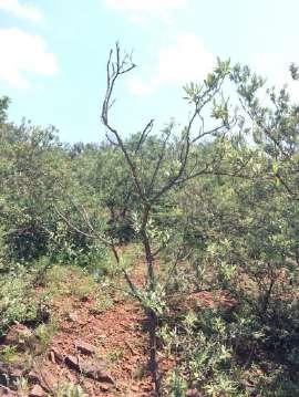


90 A P P E N D I C E S Makadima Site photographs taken in the eight major compass directions Appendix C, Page 2
91 A P P E N D I C E S DRAFT BASIC ASSESSMENT REPORT PROPOSED DEVELOP MENT OF LEISURE AND CU LT U RAL VILLAGE ON FARM MOILOA 412 -JO, DINOKANA VILLAGE, NO R TH W EST. N/A (detailed illustrations still to be provided by project developer)
92 A P P E N D I C E S DRAFT BASIC ASSESSMENT REPORT PROPOSED DEVELOP MENT OF LEISURE AND CU LT URAL VILLAGE ON FARM MOILOA 412 -JO, DINOKANA VILLAGE, NO R TH W EST. N/A (Developer to submit request for confirmation of services with Ramotshere Moiloa Municipality) Appendix E, Page 1
93 A P P E N D I C E S DRAFT BASIC ASSESSMENT REPORT PROPOSED DEVELOP MENT OF LEISURE AND CU LT U RAL VILLAGE ON FARM MOILOA 412 -JO, DINOKANA VILLAGE, NO R TH W EST. Appendix F, Page 1
94
95
96 3. Declaration by Specialist Surina Laurie the CSIR I, ( Name of Specialist) of (name of company) declare that; I act as an independent specialist in this application. I will perform the work relating to the application in an objective manner, even if this results in views and findings that are not favourable to the applicant. there are no circumstances that may compromise my objectivity in performing such work; I have expertise in conducting the specialist report relevant to this application, including knowledge of the Act, Regulations and any guidelines that have relevance to the proposed activity; I will comply with the Act, Regulations and all other applicable legislation; I have no, and will not engage in, conflicting interests in the undertaking of the activity; I undertake to disclose to the applicant/ Environmental Assessment Practitioner appointed by applicant and the competent authority all material information in my possession that reasonably has or may have the potential of influencing any decision to be taken with respect to the application by the competent authority; and the objectivity of any report, plan or document to be prepared by myself for submission to the competent authority; all the particulars furnished by me in this form are true and correct; and I realise that a false declaration is an offence in terms of Regulation 48 and is punishable in terms of Section 48B(2) of the Act. Signature of the specialist The CSIR Name of company (if applicable) 19 December 2017 Date Signature of the Commissioner of Oaths Date Designation Official stamp: Details and Expertise of Specialist and Department of Rural, Environment Page 3 Declaration of Interest and Agricultural Development EIA Regulations, 2014
97 A P P E N D I C E S DRAFT BASIC ASSESSMENT REPORT PROPOSED DEVELOP MENT OF LEISURE AND CU LT URAL VILLAGE ON FARM MOILOA 412 -JO, DINOKANA VILLAGE, NO R TH W EST. APPENDIX G: SPECIALIST REPORTS Appendix G, Page 1
98
 888 2432 Fax: (021) 888 2473 Compiled By: Natural Scientific Services CC 64 Coleraine Dr River Club Ext 7 Sandton 2191 Tel: (011) 787-7400")
99 EcoScan for Makadima Cultural Village PROPOSED MAKADIMA LEISURE & CULTURAL VILLAGE IN NORTH WEST PROVINCE ECOSCAN REPORT Compiled For: CSIR Stellenbosch (CAS, EMS) 11 Jan Cilliers Street Stellenbosch, 7600 Western Cape, South Africa Tel: (021) Fax: (021) Compiled By: Natural Scientific Services CC 64 Coleraine Dr River Club Ext 7 Sandton 2191 Tel: (011) Fax: (011) COPYRIGHT WARNING With very few exceptions the copyright of all text and presented information is the exclusive property of Natural Scientific Services. It is a criminal offence to reproduce and/or use, without written consent, any information, technical procedure and/or technique contained in this document. Criminal and civil proceedings will be taken as a matter of strict routine against any person and/or institution infringing the copyright of Natural Scientific Services. Ref No: 2391 Date: November 2017 i Natural Scientific Services CC
100 EcoScan for Makadima Cultural Village EXECUTIVE SUMMARY Natural Scientific Services CC was appointed by the Council for Scientific and Industrial Research to perform a floral, faunal and wetland ecoscan assessment (with in situ water testing) for the proposed Makadima Leisure and Cultural Village on the Farm Moiloa 412-JO in Dinokana, North West Province. Desktop research and findings from our site visit in October 2017 confirmed that the Dinokana Eye, which is a sacred cultural feature, a local important water source, and a national Freshwater Ecosystem Priority Area (FEPA), has Very High sensitivity and conservation importance. By law wetland systems are deemed sensitive and should be protected by a minimum 100m buffer, measured from the edge of the riparian zone. Surrounding hills and ridges, which intrude into the study area, and which may support conservation important species, were rated with High conservation importance. Some large indigenous trees that remain in the study area, and which are targeted for medicinal or other purposes, are at high risk of extirpation and deserve improved protection. Summarized in the Table below are potential impacts of the proposed development on biodiversity, without and with mitigation. Without mitigation, the most significant potential impacts include: Destruction of the in situ wetland system (which represents a national FEPA) during construction of the development. Contamination of surface and groundwater from poor management of construction, operation and decommissioning activities (e.g. cement mixing), poor sanitation, and waste. Increased dust, erosion and sedimentation from development activities and livestock overgrazing. Clearing of (especially riparian) vegetation and faunal habitats during construction. Introduction and proliferation of invasive alien flora from the influx of vehicles, people and materials, soil disturbance, and uncontrolled livestock activity. Increased harvesting and hunting of flora and fauna resulting in possible extirpation of targeted taxa such as remaining large indigenous trees. Increased noise, light and other forms of sensory disturbance of fauna from development activities. Table Summary of impact significance, without and with mitigation POTENTIAL IMPACTS SIGNIFICANCE CONSTRUCTION Without mitigation With mitigation Direct loss of wetlands Fatally flawed Medium Contamination of surface and groundwater resources High Low Increased dust and erosion High Low Increased sediment loads Medium Low Increased flood peaks Medium Low ii Natural Scientific Services CC
101 EcoScan for Makadima Cultural Village POTENTIAL IMPACTS SIGNIFICANCE Decreased water inputs Medium Low Clearing of (especially riparian) vegetation and faunal habitats High Medium Introduction and establishment of alien species High Low Loss of CI or medicinal flora High Low Sensory disturbance of fauna Medium Low Loss of CI fauna Medium Low Altered burning Medium Low OPERATION Further loss / degradation of wetlands High Medium Contamination of surface and groundwater resources High Low Decreased water inputs Medium Low Continued introduction and proliferation of alien species High Low Loss of CI or medicinal flora High Low Sensory disturbance of fauna High Medium Loss of CI fauna Medium Low Erosion High Low Altered burning Medium Low DECOMMISSIONING Further loss / degradation of wetlands High Medium Contamination of surface and groundwater resources High Low Increased dust and erosion High Low Increased sediment loads Medium Low Continued proliferation of alien species High Low Loss of CI or medicinal flora High Low Sensory disturbance of fauna Medium Low Loss of CI fauna Medium Low Altered burning Medium Low With the implementation of the mitigation measures suggested in this report, the significance of impacts on site can be reduced to Medium or Low. Based on the information obtained in the site visit and the information that was available to date, it is NSS s opinion that the project should only go ahead provided that the recommended mitigation measures are diligently implemented. Most importantly, the Dinokana Eye wetland system must be protected from all forms of disturbance, and the various recommended wetland buffers must be strictly adhered to. iii Natural Scientific Services CC
; Have and will not have")
102 EcoScan for Makadima Cultural Village DECLARATION I, Susan Abell, in my capacity as a specialist consultant, hereby declare that I - Act as an independent consultant; Do not have any financial interest in the undertaking of the activity, other than remuneration for the work performed in terms of the National Environmental Management Act, 1998 (Act 107 of 1998); Have and will not have vested interest in the proposed activity proceeding; Have no, and will not engage in, conflicting interests in the undertaking of the activity; Undertake to disclose, to the competent authority, any material information that has or may have the potential to influence the decision of the competent authority or the objectivity of any report, plan or document required in terms of the National Environmental Management Act, 1998 (Act 107 of 1998); Will provide the competent authority with access to all information at my disposal regarding the application, whether such information is favourable to the applicant or not; As a registered member of the South African Council for Natural Scientific Professions, will undertake my profession in accordance with the Code of Conduct of the Council, as well as any other societies to which I am a member; Based on information provided to me by the project proponent and in addition to information obtained during the course of this study, have presented the results and conclusion within the associated document to the best of my professional ability; and Reserve the right to modify aspects pertaining to the present investigation should additional information become available through ongoing research and/or further work in this field. Susan Abell Pr.Nat.Sci. November 2017 SACNASP Reg. No /05 Date (Ecological & Environmental Science) iv Natural Scientific Services CC
103 EcoScan for Makadima Cultural Village LIST OF ACRONYMS & ABBREVIATIONS ACRONYM DESCRIPTION ADU Animal Demography Unit a research unit of the Department of Zoology at the University of Cape Town AGIS Agricultural Geo-referenced Information System CARA Conservation of Agricultural Resources Act (Act 43 of 1983) CBA Critical Biodiversity Area CI Conservation Important CITES Convention on International Trade in Endangered Species of Wild Fauna and Flora C-Plan Conservation Plan CR Critically Endangered CRSA Constitution of the Republic of South Africa (Act 108 of 1996). CSIR Council for Scientific and Industrial Research D Declining population trend d Dominant DACE Department of Agriculture, Conservation and Environment DD Data Deficient DEA Department of Environmental Affairs DEAT Department of Environmental Affairs and Tourism DREAD Department of Rural, Environment and Agricultural Development DWA Department of Water Affairs (previously known as DWAF) DWAF Department of Water Affairs and Forestry DWS Department of Water and Sanitation (previously known as DWAF and DWA) ECA Environmental Conservation Act (Act 73 of 1989) EIS Ecological Importance & Sensitivity EMC Ecological Management Class EN Endangered End Endemic ES Ecological Sensitivity ESA Ecological Support Area EW Extinct in the Wild EWT Endangered Wildlife Trust EX Extinct FEPA Freshwater Ecosystem Priority Area GG Government Gazette GIS Geographic Information System GN Government Notice GN Government Notice HGM Hydro-geomorphic I Increasing IA Impact Assessment IBA Important Bird Area IUCN International Union for Conservation of Nature and Natural Resources, based in v Natural Scientific Services CC
104 EcoScan for Makadima Cultural Village ACRONYM DESCRIPTION Gland, Switzerland LC Least Concern LoO Likelihood of Occurrence of a taxon in an area NBI National Botanical Institute NE Not Evaluated NEM:AQA National Environmental Management: Air Quality Act (Act 39 of 2004) NEM:BA National Environmental Management: Biodiversity Act (Act 10 of 2004) NEM:PAA National Environmental Management: Protected Areas Act (Act 57 of 2003) NEM:WA National Environmental Management: Waste Act (Act 59 of 2008) NEMA National Environmental Management Act (Act 107 of 1998) NEPAD New Partnership for Africa s Development NFAPTS National Forests Act (Act 84 of 1998) and Protected Tree Species NFEPA National Freshwater Ecosystem Priority Areas project NHRA National Heritage Resources Act (Act 25 of 1999) NMPRDA National Mineral and Petroleum Resources Development Act (Act 28 of 2002) NSS Natural Scientific Services CC NT Near Threatened NVFFA National Veld and Forest Fire Act (Act 101 of 1998) NWA National Water Act (Act 36 of 1998) OG Ordinary Game PES Present Ecological State PG Protected Game POSA Plants of Southern Africa (website) Pr.Nat.Sci. Professional Natural Scientist PRECIS Pretoria (PRE) Computerised Information System PS Protected Species PWA Protected Wild Animal QDS Quarter Degree Square the basic unit used by the Surveyor General for creation of 1: topographical maps S Stable population trend SABAP 1 & 2 First and second Southern African Bird Atlas Projects, managed by the ADU SACNASP South African Council for Natural Scientific Professions SANBI South African National Biodiversity Institute SCH Schedule Species ToPS Threatened or Protected Species U Unknown population trend UJ University of Johannesburg UP University of Pretoria VU Vulnerable WA Wild Animal WITS University of the Witwatersrand WSA Water Services Act (Act 108 of 1997) vi Natural Scientific Services CC
105 EcoScan for Makadima Cultural Village TABLE OF CONTENTS 1. Introduction Terms of Reference Project Team Applicable Legislation, Policies & Guidelines International Agreements Regional Agreements National Legislation National Policies, Guidelines & Programmes Provincial Legislation, Policies & Guidelines Project Description Study Region Land-use Climate Hydrology Land Types Vegetation Methodology Vegetation and Floral Communities Fauna Wetlands Impact Assessment Results Vegetation and Floral Communities Fauna Wetlands Areas of Significance International Areas of Conservation Significance National and Regional Areas of Conservation Significance Local Areas of Conservation Significance Impacts & Mitigation Impacts Management and Mitigation Recommendations Concluding Remarks References Appendices POSA list for QDS 2525BD vii Natural Scientific Services CC
106 EcoScan for Makadima Cultural Village Mammal list for the study area Bird list for the study area Reptile list for the study area Frog list for the study area Butterfly list for the study area Odonata list for the study area Scorpion list for the study area CVs of relevant Senior NSS personnel Requirements under NEM:BA which have / have not been met in this report 137 LIST OF TABLES Table 3-1 NSS project team Table 6-1 Dominant flora comprising the Dwarsberg-Swartruggens Mountain Bushveld vegetation type Table 6-2 Dominant flora comprising the Zeerust Thornveld vegetation type Table 6-3 Dominant flora comprising the Zeerust Thornveld vegetation type Table 7-1 Impact scores and Present Ecological State categories Table 7-2 Trajectory of change classes, scores and symbols Table 7-3 WET-EcoServices model of wetland ecosystem services (Kotze et al. 2000) Table 7-4 Scoring guideline Table 7-5 Ecological importance and sensitivity categories Interpretation of median scores for biotic and habitat determinants Table 7-6 Rating of impact spatial extent Table 7-7 Rating of impact duration Table 7-8 Rating of potential impact intensity Table 7-9 Rating of impact probability Table 7-10 Rating of overall impact significance Table 8-1 Top 12 dominant families and most dominant growth forms obtained from the POSA website for the QDS 2525BD, DB, 2526AC and on site Table 8-2 Broad Habitat/Vegetation communities Table 8-3 Floral species located during the EcoScan and associated Vegetation Communities Table 8-3 Numbers of conservation important plant species per Red Data category within South Africa and North West (date accessed: October 2017) Table 8-4 Potential CI species based on information obtained from 2527BB & 2527BD QDG Table 8-5 Alien and Invasive Species detected during the survey Table 8-6 Potentially occurring conservation important mammal species Table 8-7 Potentially occurring conservation important bird species viii Natural Scientific Services CC
107 EcoScan for Makadima Cultural Village Table 8-8 Potentially occurring conservation important reptile and frog species Table 8-9 Wetland summary HGM Units 1 & Table 8-10 Wetland summary HGM Unit Table 8-11 Wetland present ecological state Table 8-12 Ecosystem services supplied by the identified wetland HGM units Table 8-13 Wetland importance and sensitivity Table 10-1 Summary of impact significance, without and with mitigation Table 11-1 Impact Assessment Table 11-2 Mitigation measures LIST OF FIGURES Figure 6-1 Photographs of the site Figure 6-2 Site location Figure 6-3 Measurements of monthly rainfall at Zeerust ( 17 Figure 6-4 Ecoregion and quaternary catchment wherein the development site is situated Figure 6-5 Regional vegetation and land type wherein the development site is situated Figure 7-1 Vegetation sampling points Figure 7-2 IUCN Red List categories Figure 7-3 Simple depiction of terrain units (adapted from DWAF 2005) Figure 7-4 Primary wetland HGM types, highlighting dominant water inputs throughputs & outputs (Ollis et al. 2013) Figure 8-1 Photographs of the different habitats within and surrounding the site Figure 8-2 Examples of species found on site Figure 8-3 Vegetation communities within the study area Figure 8-4 Photographs of Conservation Important or unique plant species on Site. 47 Figure 8-5 Photographic representation of alien species found in the study area Figure 8-6 Evidence of mammal species in the study area Figure 8-7 Evidence of reptile and frog species on site Figure 8-8 Evidence of butterfly species on site Figure 8-9 Evidence of odonata species on site Figure 8-10 Flow volumes recorded at the upper Dinokana Eye (data courtesy of DWS) Figure 8-11 Water quality and flow data from the upper Dinokana wetland (data courtesy of DWS) Figure 8-12 Current wetland extent Figure 8-13 Examples of existing wetland impacts Figure 9-1 Location of the site in relation to Important Bird Areas, and Protected Areas ix Natural Scientific Services CC
108 EcoScan for Makadima Cultural Village Figure 9-2 Location of the site relative to regional terrestrial Priority Areas and Threatened Ecosystems Figure 9-3 Location of the site in relation to regional Freshwater Ecosystem Priority Areas Figure 9-4 Location of the site in relation to North West CBAs and ESAs Figure 9-5 Areas of biodiversity conservation concern, superimposed with Makadima s proposed infrastructure layout Figure 10-1 Examples of potential picnic spot designs (from existing sites around the Savanna biome) blending into the surrounding environment Figure 11-1 Areas of biodiversity conservation concern, superimposed with NSS s proposed infrastructure layout x Natural Scientific Services CC
 provides for the integration of social, economic and environmental factors into planning, implementation and decisionmaking so as to")
109 EcoScan for Makadima Cultural Village 1. Introduction South African legislation affirms the national commitment to conservation. The National Environmental Management Act (NEMA; Act 107 of 1998) provides for the integration of social, economic and environmental factors into planning, implementation and decisionmaking so as to ensure that development serves present and future generations." The National Environmental Management: Biodiversity Act (NEM:BA; Act 10 of 2004) affords inter alia: the management and conservation of South Africa s biodiversity within the framework of NEMA; the protection of species and ecosystems that warrant national protection; and the sustainable use of indigenous biological resources. The National Water Act (NWA; Act 36 of 1998) is the principle legal instrument relating to water resource management in South Africa. All wetlands are protected under the NWA, wherein numerous measures are stipulated which are together intended to ensure the comprehensive protection of all water resources. The Council for Scientific and Industrial Research s (CSIR s) Special Needs Skills and Development Programme is currently undertaking the necessary environmental authorisations under NEMA, NEM:BA and the NWA for the proposed Makadima Leisure and Cultural Village on the Farm Moiloa 412-JO in Dinokana, North West Province. To this end the CSIR appointed Natural Scientific Services CC (NSS) to perform a floral, faunal and wetland ecoscan assessment (with in situ water testing) for the proposed project. Biodiversity is defined as " the variability among living organisms from all sources including terrestrial, marine and other aquatic ecosystems and the ecological complexes of which they are a part; this includes diversity within species, between species and of ecosystems" (The Convention of Biological Diversity, 1992). In other words, plants, animals and micro-organisms, their genes, and the ecosystems that living organisms inhabit, are all facets of biodiversity. 2. Terms of Reference The ecoscan was performed according to the methodology agreed between the CSIR and NSS and in accordance with current requirements under NEM:BA (Appendix 6 GN R982) - as indicated in the appended table under section this report includes: A broad description of (relevant) biophysical attributes of the study area; A list of applicable legislation, guidelines, standards and criteria to be considered in project planning; A broad determination of the (national and provincial) conservation importance of local biodiversity; A description of in situ vegetation and floral communities, including their structure, dominant plant species composition and condition; 11 Natural Scientific Services CC
110 EcoScan for Makadima Cultural Village Discussion about observed and potentially occurring conservation important (e.g. Protected, Red List and medicinal) species; An assessment of potential impacts of the proposed project on biodiversity, and recommended measures to mitigate these. 3. Project Team All aspects of the ecoscan were performed by NSS (Table 3-1). The NSS team has extensive experience in completing biodiversity assessments involving floral, faunal, wetland and aquatic work, as well as Environmental Impact Assessments, Environmental Management Programme Reports, Strategic Management Plans and Environmental Management Plans for the conservation, mining, waste, commercial and industrial sectors. In terms of accreditation and professional registrations the following is applicable to NSS: Senior team members are registered Professional Natural Scientists in the ecological, environmental and zoological fields. The CVs of Senior NSS personnel who were involved in the present assessment have been appended under section The senior wetland team member is acknowledged by the Department of Water and Sanitation (DWS) as a competent wetland delineator. Table 3-1 NSS project team ROLE NAME QUALIFICATIONS Flora Susan Abell M.Sc. Resource Conservation Biology (WITS). Pr.Sci.Nat. registered (400116/05) Ecology & Environmental Science Fauna Dr Caroline Lötter Ph.D. Zoology (UP). Pr.Sci.Nat. registered (400182/09) Zoology. Wetlands Tyron Clark M.Sc. Zoology (WITS) in progress. GIS Mapping Tim Blignaut B.Sc. Honours - Geography (UJ). 4. Applicable Legislation, Policies & Guidelines Legislation, policies and guidelines, which could apply to impacts of the proposed project on biodiversity, are listed below. Although the list is comprehensive, additional legislation, policies and guidelines that have not been mentioned may apply International Agreements Convention on International Trade in Endangered Species of Wild Fauna and Flora (CITES). (Bonn) Convention on the Conservation of Migratory Species of Wild Animals. Convention on Biological Diversity including eco-systems and genetic resources. 12 Natural Scientific Services CC
111 EcoScan for Makadima Cultural Village Agenda 21 regarding the sustainable development at global and national levels. Johannesburg Declaration and Plan of Implementation for sustainable development Regional Agreements Action Plan of the Environmental Initiative of NEPAD for sustainable development in Africa National Legislation Conservation of Agricultural Resources Act (Act 43 of 1983). Environmental Conservation Act (Act 73 of 1989). Constitution of the Republic of South Africa (Act 108 of 1996). Water Services Act (Act 108 of 1997). National Water Act (Act 36 of 1998). National Forests Act (Act 84 of 1998) and Protected Tree Species. National Veld and Forest Fire Act (Act 101 of 1998). National Environmental Management Act (NEMA; Act 107 of 1998). National Heritage Resources Act (Act 25 of 1999). National Mineral and Petroleum Resources Development Act (Act 28 of 2002). Draft Sustainable Utilization of Agricultural Resources Bill (2003). National Environmental Management: Protected Areas Act (Act 57 of 2003). National Environmental Management: Biodiversity Act (NEM:BA; Act 10 of 2004): oo National list of Ecosystems Threatened and in need of Protection (Government Gazette [GG] 34809, Government Notice [GN] 1002, 9 December 2011). oo Alien and Invasive Species Regulations (GG 37885, 1 August 2014). oo Threatened or Protected Species Regulations (GG 587, GN 38600, 31 March 2015). National Environmental Management: Air Quality Act (Act 39 of 2004). National Environmental Management: Waste Act (Act 59 of 2008) National Policies, Guidelines & Programmes National Aquatic Ecosystem Health Monitoring Program including the River Health Programme (initiated by the DWAF, now the DWA), which has recently been replaced with the River Eco-status Monitoring Programme. South African Water Quality Guidelines (DWAF 1996). White Paper on Environmental Management Policy for South Africa (1998). National Spatial Biodiversity Assessment (Driver et al. 2004) including Priority Areas and Threatened Ecosystems. National Biodiversity Strategy and Action Plan (DEAT 2005). National Freshwater Ecosystem Priority Areas project (Driver et al. 2011). Mining and Biodiversity Guideline (DEA et al. 2013). National Water Resource Strategy (DWAF 2013). Draft national guidelines on biodiversity offsets (DEA 2012 and 2015). 13 Natural Scientific Services CC
112 EcoScan for Makadima Cultural Village 4.5. Provincial Legislation, Policies & Guidelines North West Biodiversity Conservation Act (Act 4 of 2016). Transvaal Nature Conservation Ordinance (1983). North West State of the Environment Report (Walmsley & Walmsley 2002). North West Environmental Outlook Report (DACE 2008). North West Conservation Plan (C-Plan; DREAD 2012). 5. Project Description The Makadima Leisure and Cultural Village will be based on the Farm Moiloa 412-JO in Dinokana, outside of Zeerust, in Ngaka Modiri District, North West Province. The purpose of the Village is to showcase the culture of different tribes in the province. The project team identified an increasing interest and curiosity by tourists in cultural villages within the region, and found that there is a high need in the area and surrounding towns of Mafikeng, Zeerust, Rustenburg and Lichtenburg. The project will generate 20 permanent and 50 temporary employment opportunities for people from Dinokana, and will hopefully also create business opportunities for villagers (CSIR 2017). The farm portion is 85ha but the total development footprint will be approximately 10ha. The Village will comprise various developments, which will be built in phases over three years. Accommodation and leisure facilities will be constructed first, followed by the cultural village, recreational facilities, and an adventure park. The 2.5ha accommodation facilities will include 16 hotel rooms, 5 couple chalets, and 6 family chalets. The 1.5ha leisure facilities will consist of picnic gardens and a swimming pool. The 1ha Cultural Village will consist of a boma, craft market, and arts and culture museum. The 2ha recreational facilities will include an outdoor gym, braai area and park benches. The 3ha adventure park will comprise a race track for gokarts and quad bikes (CSIR 2017). The entire development should receive 150 visitors per day, and accommodate a maximum of 48 people at a time. The conference facility will take up to 40 team members, and 55 guests will be allowed in the Village at a time (CSIR 2017). 6. Study Region 6.1. Land-use The project site is surrounded by the rural Dinokana settlement to the north and east, and mostly natural bush to the south and west, and is situated near the Dinokana Eye ( S; E) a feature considered to be a sacred site by the local community and one of the main attractions in Dinokana (CSIR 2017). The Eye is presently 14 Natural Scientific Services CC
 area enclosed by palisade and electrified fencing.")


 South-centre: valley plain")
113 EcoScan for Makadima Cultural Village protected by security guards inside a small (~1.5ha) area enclosed by palisade and electrified fencing. The security measures have been put in place by the national Department of Water and Sanitation to safeguard the Eye from degradation by people and livestock. North of the Eye is an old reservoir or dam, and south-east of the Eye is an informal soccer field. Photographs of the site are provided in Figure 6-1. Centre of study area: Dinokana Eye North: downstream from the Eye (proposed recreational park) North-centre: dam Centre: rocky hill (proposed accommodation and restaurant) South-centre: valley plain (proposed cultural village and picnic area) Figure 6-1 Photographs of the site South-east: soccer field (proposed race track and adventure facilities) 15 Natural Scientific Services CC

114 EcoScan for Makadima Cultural Village Figure 6-2 Site location 16 Natural Scientific Services CC
115 January February March April May June July August September October November December January February March April May June July August September October Rainfall (mm) Atmospheric temperature ( C) EcoScan for Makadima Cultural Village 6.2. Climate The regional climate features summer rainfall with very dry winters. Mean annual precipitation is about mm. Frost is fairly frequent in winter in lower-lying areas, but less so on the hills. Mean monthly maximum and minimum temperatures for Lindleyspoort-Irr weather station are 35.2 C and 0.4 C for January and June, respectively. Corresponding values for the Marico-Irr weather station are 36.7 C and -0.4 C (Mucina & Rutherford 2006). Shown in Figure 6-3 is monthly rainfall and atmospheric temperatures measured at Zeerust between January 2016 and November 2017 (data obtained from This approximate rainfall data indicate that during the 12- month period preceding our site visit on 19 October 2017, the region had received an average annual amount of ~567mm rain. The approximate temperature data in Figure 6-3 indicate that temperatures were generally cooler during October 2017 than during the October On the day that we visited the site, the weather was hot, and our observation of fresh sheet and gully erosion in places, indicated that the area had recently received rain. Conditions were, therefore, favourable for our floral, faunal and wetland survey work Year and month Figure 6-3 Measurements of monthly rainfall at Zeerust ( Hydrology The northern extremity of the site straddles the 7.04 ecoregion (to the north-east) and ecoregion (to the south-west), and the southern section of the farm straddles quaternary catchment A10A (to the north-east) and D41A (to the south-west; Figure 6-4). Both catchments have been rated with HIGH (Low Confidence) Ecological Sensitivity (ES), (DWAF 2011). The Dinokana Eye drains into the Ngotwane River, which enters the Limpopo River at Pala Camp, north-east of Gaborone. The Limpopo eventually flows through the 17 Natural Scientific Services CC
116 EcoScan for Makadima Cultural Village Kruger National Park before entering Mozambique. In contrast, quaternary catchment D41A feeds the Ramatlabama River, which enters the Molopo River, and which eventually drains into the Orange River Land Types Land types, which have been identified by the ARC s Institute for Soil, Climate and Water, represent areas that are uniform with respect to climate, terrain form, geology and soil. The data, obtained through the Agricultural Geo-referenced Information System (AGIS 2010), provide useful baseline information on land capability (especially agricultural potential). According to this data, most of the project footprint is situated in land type Ib40. The northern extremity of the site enters land type Ae33, and the southern section of the farm is situated in land type Fa9 (Figure 6-5). Land type Ib40 features shales, quartzites and andesites of the Pretoria Group (Transvaal Supergroup) with stony shallow soils of the Glenrosa and Mispah soil forms, with some deep, freely drained soils. Within land type Ae33, sediments of the Pretoria Group (Transvaal Supergroup) - particularly the Silverton and Rayton Formations - are mostly shale with less quartzite and conglomerate. Carbonates, volcanic rocks, breccias and diamictites also occur in the Pretoria Group. Bronzite, harzburgite, gabbro and norite of the Rustenburg Layered Suite (Bushveld Igneous Complex) are also found. Soils are mostly deep, redyellow, apedal, freely drained with high base status also with some vertic or melanic clays. Land type Fa9, in contrast, features dolomite and chert of the Malmani Subgroup (Transvaal SuperGroup) supporting mostly shallow Mispah and Glenrosa soil forms Vegetation The project footprint is situated in the Savanna Biome, mainly within the SVcb 4 Dwarsberg- Swartruggens Mountain Bushveld regional vegetation type, but with the north-eastern extremity of the study area situated in the Svcb 3 Zeerust Thornveld vegetation type - as defined by Mucina & Rutherford (2006). To the south-west, the remainder of the farm portion straddles the Dwarsberg-Swartruggens Mountain Bushveld and the Gh 15 Carletonville Dolomitic Grassland vegetation types (Figure 6-5). Dwarsberg-Swartruggens Mountain Bushveld features rocky, low to medium-high hills and ridges with steep faces in places (reaching about 300m in height above the surrounding plains). The structure of the vegetation is variable depending on slope, exposure, aspect and local habitat. Various combinations of tree and shrub layers occur, often with a dense grass layer. Bush clumps also occur. Dominant floral species within the Dwarsberg-Swartruggens Mountain Bushveld vegetation type are listed in Table 6-1. Although this vegetation type is not threatened, less than 2% is statutorily conserved (mainly in the Marico Bushveld Nature Reserve). Approximately 7% of the vegetation type has been transformed, mainly by cultivation, and scattered alien flora (e.g. Cereus jamacaru and Acacia mearnsii) occur in places. Erosion is mostly very low to low (Mucina & Rutherford 2006). 18 Natural Scientific Services CC
117 EcoScan for Makadima Cultural Village Zeerust Thornveld represents deciduous, open to dense, short, thorny woodland dominated by Acacia species with a herbaceous layer of mainly grasses. It is found on deep, high-base status and some clay soils on plains and lowlands, and also between rocky ridges of Dwarsberg-Swartruggens Mountain Bushveld. Zeerust Thornveld is also Least Threatened, but less than 4% is statutorily conserved between four reserves including the Pienaar and Marico Bushveld Nature Reserves. About 16% of the vegetation type has been transformed, mainly by cultivation, but also urban development. Alien flora (e.g. Cereus jamacaru) occur in a few very scattered areas. Erosion is also very low to low (Mucina & Rutherford 2006). Carletonville Dolomitic Grassland is found on slightly undulating plains, dissected by prominent rocky chert ridges. This species-rich grassland type forms a complex mosaic pattern dominated by many species. It is listed as Vulnerable, with only a small extent of this vegetation type privately and statutorily conserved (in the Cradle of Humankind World Heritage, Oog van Malmanie, Abe Bailey, Boskop Dam, Schoonspruit, Krugersdorp, Olifantsvlei and Groenkloof protected areas). Almost a quarter of the Carletonville Dolomitic Grassland vegetation type has been transformed by cultivation, mining, urban development and damming. Erosion is very low to low (Mucina & Rutherford 2006). Table 6-1 vegetation type Dominant flora comprising the Dwarsberg-Swartruggens Mountain Bushveld GROWTH FORM DOMINANT SPECIES Tall Tree: Acacia robusta (d) Small Trees: Acacia caffra (d), A. erubescens (d), Burkea africana (d), Combretum apiculatum (d), Faurea saligna (d), Protea caffra (d), Combretum imberbe, C. molle, Cussonia paniculata, C. transvaalensis, Dombeya rotundifolia, Ozoroa paniculosa, Pappea capensis, Peltophorum africanum, Spirostachys africana, Vangueria infausta, Ziziphus mucronata. Succulent Tree: Aloe marlothii subsp. marlothii (d). Tall Shrubs: Dichrostachys cinerea (d), Croton pseudopulchellus, Ehretia rigida subsp. rigida, Grewia flava, Mundulea sericea, Tarchonanthus camphoratus, Vitex zeyheri. Low Shrubs: Athrixia elata, Pavonia burchellii, Searsia magalismontana subsp. magalismontana, S. rigida var. rigida. Woody Climber: Asparagus africanus. Graminoids: Aristida canescens (d), Cenchrus ciliaris (d), Chrysopogon serrulatus (d), Digitaria eriantha subsp. eriantha (d), Enneapogon scoparius (d), Loudetia simplex (d), Schizachyrium sanguineum (d), Setaria lindenbergiana (d), Bewsia biflora, Bothriochloa insculpta, Cymbopogon caesius, C. pospischilii, Elionurus muticus, Eragrostis rigidior, Fingerhuthia africana, Heteropogon contortus, Melinis nerviglumis, Panicum maximum, Setaria sphacelata, Themeda triandra, Trachypogon spicatus, Tristachya biseriata. Herbs: Barleria macrostegia, Commelina africana, Hermannia depressa, Senecio venosus. Geophytic Herbs: Hypoxis hemerocallidea, Pellaea calomelanos, Tritonia nelsonii. *The genus Acacia has been split internationally into Vachellia and Senegalia. For this report, these species will remain in the Acacia genus. * d = Dominant 19 Natural Scientific Services CC
118 EcoScan for Makadima Cultural Village Table 6-2 Dominant flora comprising the Zeerust Thornveld vegetation type GROWTH FORM DOMINANT SPECIES Tall Trees: Acacia burkei (d), Acacia erioloba (d). Small Trees: Acacia mellifera subsp. detinens (d), Acacia nilotica (d), Acacia tortilis subsp. heteracantha (d), Searsia lancea (d), Acacia fleckii, Peltophorum africanum, Terminalia sericea. Tall Shrubs: Diospyros lycioides subsp. lycioides, Grewia flava, Mystroxylon aethiopicum subsp. burkeanum. Low Shrubs: Agathisanthemum bojeri, Chaetacanthus costatus, Clerodendrum ternatum, Indigofera filipes, Searsia grandidens, Sida chrysantha, Stylsanthes fruticosa. Graminoids: Eragrostis lehmanniana (d), Panicum maximum (d), Aristida congesta, Cymbopogon pospischilii. Herbs: Blepharis integrifolia, Chamaecrista absus, C. mimosoides, Cleome maculata, Dicoma anomala, Kyphocarpa angustifolia, Limeum viscosum, Lophiocarpus tenuissimus. *The genus Acacia has been split internationally into Vachellia and Senegalia. For this report, these species will remain in the Acacia genus. * d = Dominant Table 6-3 Dominant flora comprising the Zeerust Thornveld vegetation type GROWTH FORM DOMINANT SPECIES Low shrubs Anthospermum rigidum subsp. pumilum, Indigofera comosa, Pygmaethamnus zeyheri var. rogersii, Rhus magaliesmontana, Tylosema esculentum, Ziziphus zeyheriana, Geoxylic suffrutex Elephantorrhiza elephantina, Parinari capensis subsp. capensis Graminoids Aristida congesta, Brachiaria serrata, Cynodon dactylon, digitaria tricholaenoides, Hiheteropogon ampletens, Eragrostis chloromelas, E. racemosa, Heteropogn contortus, Loudetia simplex, Schizachyrium sanguineum, Setaria sphacelata, Themeda triandra, Alloteropsis semilata subsp. eckloniana, Andropogon schirensis, Aristida canescens, A. diffusa, Bewsia bifola, Bulbostylis burchellii, Cymbopogan caesius, C. pospibiflora, Elinonurus muticus, Eragrostis curvula, E. gummiflua, E. plantana, Eustachys paspaloides, Hyparrhenia hirta, Melinis nerviglumis, M. repens subsp. repens, Monocymbium ceresiiforme, Panicum coloratum, Pogonarthria squarrosa, Trichoneura grandiglumis, Triraphis andropogonoides, Tristachya leucothrix, T. rehmannii Herbs Aclypha angustata, Barleria macthrix, Chamaecrista mimosoides, Chamaesyce inaequilatera, Crabbea angustifolia, Dianthus mooiensis, Dicoma anomala, Helichrysum caespititium, H. Miconiifolium, H. nudifolium var. nudifolium, Ipomoea ommaneyi, Justicia anagalloides, Kohautia amatymbica, Kyphocarpa angustifolia, Ophrestia oblongifolia, Pollichia campestris, Sencio coronatus, Vernonia oligocephala. Geophytic herbs Boophane disticha, Habenaria mossii *The genus Acacia has been split internationally into Vachellia and Senegalia. For this report, these species will remain in the Acacia genus. * d = Dominant 20 Natural Scientific Services CC

119 EcoScan for Makadima Cultural Village Figure 6-4 Ecoregion and quaternary catchment wherein the development site is situated 21 Natural Scientific Services CC

120 EcoScan for Makadima Cultural Village Figure 6-5 Regional vegetation and land type wherein the development site is situated 22 Natural Scientific Services CC
121 EcoScan for Makadima Cultural Village 7. Methodology The ecological scan involved desktop research and fieldwork, which was performed during a site visit on 19 October Vegetation and Floral Communities Desktop Research A desktop assessment of the regional vegetation and potential local floral communities was performed using Mucina and Rutherford s (2006) vegetation map of southern Africa, the current biodiversity Sector or Conservation Plan (C-Plan) for North West Province, and SANBI s 1 Plants of South Africa (POSA) data for quarter degree square (QDS) 2525BD. Conservation Important (CI) plant species records from the study region were sourced mainly from POSA, and the local Likelihood of Occurrence (LO) of each species was rated, based on in situ environmental conditions, as: present, high, possible, low or unlikely due to e.g. a lack of suitable habitat Fieldwork In situ vegetation was sampled at multiple points (mapped in Figure 7-1) using the Braun- Blanquet approach. Floral community structure, condition and species composition and cover abundance was noted at each sampling point. Observed flora were identified to species level except when features for specimen identification were limited, in which case the epithet cf (meaning confer or looks like ) has been used. Plant scientific names follow those of POSA (accessed in October 2017). Observed alien and invasive plant species were also recorded, as listed under both the Conservation of Agricultural Resources Act (Act 43 of 1983) and the National Environmental Management: Biodiversity Act (Act 10 of 2004) Alien and Invasive Species Regulations published on 1 August 2014 in Government Gazette Limitations The short duration of fieldwork. Plant species with short flowering times, or which are small, rare or otherwise difficult to detect may not have been detected even though they are potentially present. Delineation of the identified floral communities might not be exact due to variable infield GPS accuracy, potential georeferencing errors and outdated imagery from Google Earth. 1 The South African National Biodiversity Institute 23 Natural Scientific Services CC

122 EcoScan for Makadima Cultural Village Figure 7-1 Vegetation sampling points 24 Natural Scientific Services CC
123 EcoScan for Makadima Cultural Village 7.2. Fauna Desktop Research A list of species potentially occurring in the study area was compiled for: Mammals, including bats, using the published species distribution maps in Friedmann & Daly (2004) and Stuart & Stuart (2007), and Monadjem et al. (2010), respectively, and online species distribution data from MammalMAP (2017) for quarter degree square (QDS) 2525BD. Birds, using the list of bird species for QDS 2525BD from the Roberts VII (2013) mobile phone app., and the latest online list of bird species for pentad 2525_2550 from the second Southern African Bird Atlas Project (SABAP 2), which included records of bird species that were observed in QDS 2525BD during the first SABAP (SABAP 1). Reptiles, using the published species distribution maps in Bates et al. (2014), and online species distribution data from ReptileMAP (2017) for the relevant QDS. Frogs, using the published species distribution maps in Minter et al. (2004), and online species distribution data from FrogMAP (2017) for the relevant QDS. Butterflies, using the published species distribution maps in Mecenero et al. (2013). LepiMAP (2017) had only one species record for QDS 2525BD. Odonata, using the published distribution maps in Samways (2008). OdonataMAP (2017) did not have any species records for QDS 2525BD. Scorpions, using the published species distribution maps in Leeming (2003). ScorpionMAP (2017) did not have any species records for QDS 2525BD. The lists were refined based on faunal records for the Dwarsberg-Swartruggens Mountain Bushveld, Zeerust Thornveld and Carletonville Dolomitic Grassland regional vegetation types in North West Province, which were received from DREAD (pers. comm. 2016), and our field observations, where the Likelihood of Occurrence (LO) of each species was rated using the following scale: 1 Present: the species, or signs of its presence, was recorded. 2 High: the species is highly likely to occur. 3 Moderate: the species may occur. 4 Low: the species is unlikely to occur Fieldwork Faunal observations were made while driving, walking, and inspecting different habitats in the study area. Taxa were identified based on observations of dead or live specimens, spoor, droppings, burrows and other evidence. Rocks and logs were turned to find reptiles, scorpions, frogs and invertebrates. A sweep net was used to catch butterflies and odonata. 25 Natural Scientific Services CC
124 EcoScan for Makadima Cultural Village Conservation Status of Species The appended faunal lists indicate the status of relevant species according to: The latest (2015) list of Threatened or Protected Species (ToPS) under the National Environmental Management: Biodiversity Act (NEM:BA 2004). The latest list of Threatened or Protected Species under the relevant provincial legislation, in this case, the Transvaal Nature Conservation Ordinance of The latest national or regional Red List assessment for: Mammals by the SANBI & EWT (2016). Birds by Taylor et al. (2015). Reptiles by Bates et al. (2014). Frogs by Minter et al. (2004). Butterflies by Mecenero et al. (2013). Dragonflies and damselflies (odonata) by Samways (2006). The IUCN Red List, where the global Red List status of a taxon has not been assessed during the relevant afore-mentioned national or regional Red List assessment. Extinct (EX) Extinct in the wild (EW) Adequate data Threatened Critically Endangered (CR) Endangered (EN) Evaluated Vulnerable (VU) Near Threatened (NT) Least Concern (LC) Data Deficient Not Evaluated Figure 7-2 IUCN Red List categories An atlas and Red List assessment for South African scorpion species has not yet been published. Due to spatio-temporal variation in human disturbances, the conservation status of some species differs between the NEM:BA, provincial legislation and the relevant regional or national Red List assessment publication. Unless otherwise stated, the most threatened status of a species is provided in text, whether this is at a global or other spatial scale. 26 Natural Scientific Services CC
125 EcoScan for Makadima Cultural Village Shown in Figure 7-2 are the IUCN s Red List categories, which have been adopted to a large extent in regional / national /provincial assessments of animal taxa Limitations The site visit was limited to a few day time hours and, therefore, not all potentially occurring (especially nocturnal) species were likely to be detected. Some species, which are uncommon, small, migratory, secretive or otherwise difficult to detect may not have been detected even though they were potentially present Wetlands Desktop Research Prior to visiting the site, the area was surveyed at a desktop level using 1: topographical maps, Google Earth Imagery, contour data, provincial and national databases, as reference material to determine the layout of the in situ wetland system Wetland Classification The wetland system was classified using the recently-published Classification system for Wetlands and other Aquatic Ecosystems in South Africa by Ollis et al. (2013), hereafter referred to as the Classification System. Ecosystems included by the Classification System encompass all those that are listed under the Ramsar Convention as wetlands 2, and include all freshwater (non-marine) systems. The Classification System recognizes three broad inland systems: rivers, wetlands and open water bodies. Like Kotze et al s (2008) classification of wetlands based on hydro-geomorphic (HGM) units, the Ollis et al. (2013) Classification System asserts that the functioning of an inland aquatic ecosystem is determined fundamentally by hydrology and geomorphology. The Classification System has a six-tiered structure where under the determination of a system s HGM unit (Level 4): Level 1 Type of system (marine, estuarine or inland). Level 2 Regional setting (Level 1 Ecoregions; NFEPA WetVeg units; etc.). Level 3 Landscape unit (valley floor, slope, plain, and bench). Level 4 Hydro-geomorphic (HGM) unit. Level 5 Hydrological regime. Level 6 Descriptors (natural vs. artificial; salinity; ph; etc.) Wetland Extent The wetland delineation method used in the field is the same as that outlined in the DWS field procedure for the identification and delineation of wetlands and riparian areas (DWAF 2005). 2 Under the Convention on Wetlands (Ramsar, Iran, 1971) "wetlands" are defined by Articles 1.1 and 2.1 as: Article 1.1: "For the purpose of this Convention wetlands are areas of marsh, fen, peatland or water, whether natural or artificial, permanent or temporary, with water that is static or flowing, fresh, brackish or salt, including areas of marine water the depth of which at low tide does not exceed six metres." Article 2.1 provides that wetlands: "may incorporate riparian and coastal zones adjacent to the wetlands, and islands or bodies of marine water deeper than six metres at low tide lying within the wetlands". 27 Natural Scientific Services CC
126 EcoScan for Makadima Cultural Village The following three indicators described by DWAF (2005) were used: Terrain Unit Indicator: The topography of the area was used to determine where in the landscape wetlands were likely to occur. McVicar et al. (1977) defines five terrain units (Figure 7-3). Most wetlands will be found in valley bottoms (unit 5), but can occur on crests, mid slopes and foot slopes (units 1, 3 and 4). Figure 7-3 Simple depiction of terrain units (adapted from DWAF 2005) Soil Wetness Indicator: The soil wetness and duration of wetness are indicated by the colour of the soil. A grey soil matrix such as a G-horizon is an indication of wetness for prolonged periods of time and mottles indicate a fluctuating water table. In terms of the DWS guidelines (DWAF 2005), signs of soil wetness must be found within the top 50cm of the soil surface to classify as a wetland. The permanent zone of a wetland is therefore characterised by grey soil, the seasonal zone has a high frequency of low chroma mottles and the temporary zone has less, high chroma, mottles. These mottles are normally most prominent just below the A-horizon. Mottles may occur in non-wetland soils that have a high chroma matrix, and the colour of the matrix must always be considered in conjunction with the presence of mottles. Vegetation Indicator: Vegetation is a key component of the wetland definition in the National Water Act (Act 36 of 1998), and vegetation can be used as an indicator of wetland conditions. The presence / absence of hydrophytes provide a useful additional criterion in determining the boundaries of wetlands Wetland Present Ecological State (PES) The PES of the in situ wetland system was assessed using the Level 1 WET-HEALTH tool of Macfarlane et al. (2008). The WET-HEALTH tool is designed to assess the health or integrity of a wetland. To assess wetland health, the tool uses indicators based on the main wetland drivers: geomorphology, hydrology and vegetation. 28 Natural Scientific Services CC
127 EcoScan for Makadima Cultural Village Macfarlane et al. (2008) explain that the application and methodology of WET-HEALTH uses: An impact-based approach, for those activities that do not produce clearly visible responses in wetland structure and function. The impact of irrigation or afforestation in the catchment, for example, produces invisible impacts on water inputs. This is the main approach used in the hydrological assessment. An indicator-based approach, for activities that produce clearly visible responses in wetland structure and function, e.g. erosion or alien plants. This approach is mainly used in the assessment of geomorphology and vegetation health. With WET-HEALTH a wetland is first classified into HGM units (Level 4 Ollis et al. 2013), and each HGM unit is separately assessed in terms of the extent, intensity and magnitude of impacts on the hydrology, geomorphology and vegetation of the unit, which is translated into a health score as follows: The extent of impact is measured as the proportion (percentage) of a wetland and/or its catchment that is affected by an activity. The intensity of impact is estimated by evaluating the degree of alteration that results from a given activity. The magnitude of impact for individual activities is the product of extent and intensity. The magnitudes of all activities in each HGM unit are then combined in a structured and transparent way to calculate the overall impact of all activities that affect a unit s hydrology, geomorphology and vegetation, and wetland PES is expressed on a scale of A-F (Table 7.1). In addition, the threat and/or vulnerability of a wetland must be assessed to determine its likely trajectory of change (Table 7-2). Overall wetland health is then jointly represented by the wetland s PES and trajectory of change. This approach not only provides an indication of hydrological, geomorphological and vegetation health, but also highlights the key causes of wetland degradation Wetland Functionality The WET-EcoServices tool of Kotze et al. (2008) provides a means for rapidly assessing ecosystem services supplied by wetlands. More specifically, the tool was designed to help assess the goods and services that individual palustrine wetlands (i.e. marshes, floodplains, vleis and seeps) provide in terms of support planning and decision-making. The wetland benefits included in the WET-EcoServices model are selected based on their importance for South African wetlands, and how readily these can be assessed. Benefits such as groundwater recharge or discharge and biomass export may be important but are 29 Natural Scientific Services CC
128 EcoScan for Makadima Cultural Village difficult to characterise at a rapid assessment level, and have thus been excluded. Detailed in Table 7-3 are the ecosystem services that are assessed during a rapid field assessment. Table 7-1 ECOLOGICAL CATEGORY Impact scores and Present Ecological State categories DESCRIPTION COMBINED IMPACT SCORE A Unmodified, natural B Largely natural with few modifications. A slight change in ecosystem processes is discernible and a small loss of natural habitats and biota may have taken place C D E F Moderately modified. A moderate change in ecosystem processes and loss of natural habitat has taken place but the natural habitat remains predominantly intact. Largely modified. A large change in ecosystem processes and loss of natural habitat and biota has occurred. Seriously modified. The change in ecosystem processes and loss of natural habitat and biota is great but some remaining natural habitat features are still recognizable. Critically modified. Modifications have reached a critical level and the ecosystem processes have been modified completely with an almost complete loss of natural habitat and biota. Source: Modified from Macfarlane et al. (2008) Table 7-2 Trajectory of change classes, scores and symbols TRAJECTORY CHANGE CLASS DESCRIPTION CLASS SCORE RANGE Improve Condition is likely to improve substantially to 2 markedly over the next five years Improve Condition is likely to improve over the next 1.3 to 1 five years Remains Condition is likely to remain stable over the to stable next five years +0.2 Deterioration Condition is likely to deteriorate slightly to -1 slight over the next five years Deterioration Condition is likely to deteriorate to 2 substantial substantially over the next five years Source: Modified from Macfarlane et al. (2008) SYMBOL Wetland Ecological Importance & Sensitivity (EIS) The assessment of wetland EIS was based on the DWAF (1999) guidelines. According to these guidelines, the "ecological importance" of a water resource is an expression of its importance to the maintenance of ecological diversity and functioning on local and wider scales. "Ecological sensitivity" refers to a system s ability to resist disturbance and its capability to recover from disturbance once this has occurred. A wetland s EIS was then used to determine its Ecological Management Class (EMC). For this, a series of 10 determinants for EIS are assessed on a scale of 0 to 4, where 0 indicates no importance, and Level 4 indicates very high importance (Table 7-4). The median of the determinants is then used to assign a wetland s EMC (Table 7-5). 30 Natural Scientific Services CC
 Primary wetland HGM types, highlighting dominant water inputs throughputs & 31 Natural")
129 EcoScan for Makadima Cultural Village Figure 7-4 outputs (Ollis et al. 2013) Primary wetland HGM types, highlighting dominant water inputs throughputs & 31 Natural Scientific Services CC
130 Cultural benefits Ecosystem Services supplied by Wetlands Direct Benefits Provisioning benefits Indirect Benefits Regulating & supporting benefits Water quality enhancements EcoScan for Makadima Cultural Village The determinants assessed include: PRIMARY DETERMINANTS Rare and endangered species - interpreted as Red Data and other Conservation Important (CI) species. Populations of unique species. Species / Taxon richness. Diversity of habitat types or features. Migration route/breeding and feeding site for wetland species. Sensitivity to changes in the natural hydrological regime. Sensitivity to water quality changes. Flood storage, energy dissipation and particulate/element removal. MODIFYING DETERMINANTS Protected status. Ecological integrity. Table 7-3 WET-EcoServices model of wetland ecosystem services (Kotze et al. 2000) Flood attenuation Streamflow regulation Sediment trapping Phosphate assimilation Nitrate assimilation Toxicant assimilation Carbon storage Erosion control Biodiversity maintenance The spreading out and slowing down of floodwaters in the wetland, thereby reducing the severity of floods downstream Sustaining streamflow during low flow periods The trapping and retention in the wetland of sediment carried by runoff waters Removal by the wetland of phosphates carried by runoff waters Removal by the wetland of nitrates carried by runoff waters Removal by the wetland of toxicants (e.g. metals, biocides and salts) carried by runoff water Controlling of erosion at the wetland site, principally through the protection provided by vegetation The trapping of carbon by the wetland, principally as soil organic matter Through the provision of habitat and maintenance of natural process by the wetland, a contribution is made to maintaining biodiversity Biodiversity maintenance is not an ecosystem service as such, but encompasses attributes widely acknowledged as having potentially high value to society Provision of water for human use The provision of water extracted directly from the wetland for domestic, agriculture or other purposes Provision of harvestable resources The provision of natural resources from the wetland, including livestock grazing, craft plants, fish, etc. Provision of cultivated foods Cultural heritage Tourism and recreation Education and research The provision of areas in the wetland favourable for the cultivation of foods Places of special cultural significance in the wetland, e.g., for baptisms or gathering of culturally significant plants Sites of value for tourism and recreation in the wetland, often associated with scenic beauty and abundant birdlife Sites of value in the wetland for education or research 32 Natural Scientific Services CC
131 EcoScan for Makadima Cultural Village Table 7-4 Scoring guideline SCORE GUIDELINE CONFIDENCE RATING Very high = 4 Very high confidence = 4 High = 3 High confidence = 3 Moderate = 2 Moderate confidence = 2 Marginal/Low = 1 Marginal/Low confidence = 1 None = 0 Table 7-5 Ecological importance and sensitivity categories Interpretation of median scores for biotic and habitat determinants RANGE OF RECOMMENDED ECOLOGICAL IMPORTANCE & SENSITIVITY (EIS) MEDIAN EMC Very high Wetlands that are considered ecologically important and sensitive >3 and <=4 on a national / international level. The biodiversity of these systems is usually very sensitive to flow and habitat modifications. A They play a major role in moderating the quantity and quality of water of major rivers. >2 and <=3 High Wetlands that are considered to be ecologically important and sensitive. The biodiversity of these systems may be sensitive to B flow and habitat modifications. They play a role in moderating the quantity and quality of water of major rivers. >1 and <=2 Moderate Wetlands that are considered to be ecologically important and sensitive on a provincial or local scale. The biodiversity of these systems is not usually sensitive to flow and habitat modifications. C They play a small role in moderating the quantity and quality of water of major rivers. >0 and <=1 Low/Marginal Wetlands which are not ecologically important and sensitive at any scale. The biodiversity of these systems is ubiquitous and not sensitive to flow and habitat modifications. They play an insignificant role in moderating the quantity and quality of water of major rivers. D Wetland buffers A wetland buffer is a strip of land surrounding a wetland in which activities are controlled or restricted. Wetland buffers serve to: reduce the impact of adjacent land uses; slow potentially erosive run-off; capture sediments; absorb nutrients; and provide habitats for wetland-dependant organisms. The reach of the Mmaphanyane on site is registered as a FEPA river and as such 100 m applies to HGM unit 1 for general developments as well as a 250 m buffer on boreholes and a 500 m buffer on herbicide application. A 50 m buffer was 33 Natural Scientific Services CC
132 EcoScan for Makadima Cultural Village assigned to HGM Unit 2 based on the GDARD minimum requirement for biodiversity assessment protocol for wetlands outside the urban edge Limitations The use of conventional redoximorphic soil indicators of wetland presence (mottles) is severely limited in the type of dolomitic derived soils present on site. This is due to the high manganese and iron content of soil (see wetland section for greater detail). The implication was that soil could not be used as a reliable wetland indicator. The riparian vegetation zone has undergone considerable clearing and thinning from the reference state. This further hampers the use of vegetation indicators to reliably delineate the wetland boundary Impact Assessment The Impact Assessment (IA) was performed according to the CSIR s IA methodology, which takes into account: Impact nature (direct, indirect and cumulative); Impact status (positive, negative or neutral); Impact spatial extent (Table 7-6); Impact duration (Table 7-7); Potential impact intensity (Table 7-8); Impact reversibility (high, moderate, low or irreversible); Irreplaceability of the impacted resource (high, moderate, low or replaceable); Impact probability (Table 7-9); Our confidence in the ratings (high, moderate or low); Overall impact significance (Table 7-10) is calculated as: Impact significance = Impact magnitude x Impact probability where Impact magnitude = Potential impact intensity + Impact duration + Impact extent Table 7-6 Rating of impact spatial extent EXTENT DESCRIPTION SCORE Site specific 1 Local (<2km from site) 2 Regional (within 30km of site) 3 National 4 International/Global 5 Table 7-7 Rating of impact duration DURATION DESCRIPTION Temporary (less than 2 years) or duration of the construction period. This impact is fully reversible. E.g. the construction noise temporary impact that is highly reversible as it will SCORE 1 34 Natural Scientific Services CC
133 EcoScan for Makadima Cultural Village DURATION DESCRIPTION stop at the end of the construction period SCORE Short term (2 to 5 years). This impact is reversible. 2 Medium term (5 to 15 years). The impact is reversible with the implementation of appropriate mitigation and management actions. Long term (>15 years but where the impact will cease after the operational life of the activity). The impact is reversible with the implementation of appropriate mitigation and management actions. E.g. the noise impact caused by the desalination plant is a long term impact but can be considered to be highly reversible at the end of the project life, when the project is decommissioned Permanent (mitigation will not occur in such a way or in such a time span that the impact can be considered transient). This impact is irreversible. E.g. The loss of a paleontological resource on site caused by construction activities is permanent and would be irreversible Table 7-8 Rating of potential impact intensity NEGATIVE POTENTIAL INTENSITY DESCRIPTION RATING SCORE Potential to severely impact human health (morbidity/mortality); or Very High/Fatal to lead to loss of species 3 (fauna and/or flora) Flaw 16 Potential to reduce faunal/flora population or to lead to severe reduction/alteration of natural process, loss of livelihoods / sever High 8 impact on quality of life 4, individual economic loss Potential to reduce environmental quality air, soil, water. Potential Loss of habitat, loss of heritage, reduced amenity Medium 4 Nuisance Medium-Low 2 Negative change with no other consequence Low 1 POSITIVE POTENTIAL INTENSITY DESCRIPTION RATING SCORE Potential Net improvement in human welfare High 8 Potential to improve environmental quality air, soil, water. Improved individual livelihoods Medium 4 Potential to lead to Economic Development Medium-Low 2 Potential positive change with no other consequence Low 1 Irreplaceable loss of a resource must be factored into the potential intensity rating of an impact Table 7-9 Rating of impact probability PROBABILITY DESCRIPTION SCORE Improbable (little or no chance of occurring <10%) 0.1 Low probability(10-25% chance of occurring) 0.25 Probable (25-50% chance of occurring) 0.5 Highly probable (50 90% chance of occurring) 0.75 Definite (>90% chance of occurring). 1 3 Note that a loss of species is a global issue and is differentiated from a loss of floral/faunal populations. 4 Note that a visual impact or air emissions for example could be considered as severely impacting on quality of life should it constitute more than a nuisance but not being life threatening. 35 Natural Scientific Services CC
134 EcoScan for Makadima Cultural Village Table 7-10 Rating of overall impact significance SCORE RATING SIGNIFICANCE DESCRIPTION Fatally The project cannot be authorised unless major changes to the engineering flawed design are carried out to reduce the significance rating High The impacts will result in major alteration to the environment even with the implementation on the appropriate mitigation measures and will have an influence on decision-making. 5-9 Medium The impact will result in moderate alteration of the environment and can be reduced or avoided by implementing the appropriate mitigation measures, and will only have an influence on the decision-making if not mitigated. <5 Low The impact may result in minor alterations of the environment and can be easily avoided by implementing appropriate mitigation measures, and will not have an influence on decision-making. 8. Results 8.1. Vegetation and Floral Communities Comparative Regional Vegetation SANBI frequently collect/collate floral data within Southern Africa and update their PRECIS database system (National Herbarium Pretoria (PRE) Computerised Information System) which is captured according to quarter degree squares (QDSs). This is referred to the POSA database. For this study, the Site falls within 2525BD, which yielded 225 species. In order to obtain a more representative sample, the QDS 2525DB and 2526AC was incorporated, which yielded 342 species from 79 families. The dominant families being POACEAE, FABACEAE and ASTERACEAE (Table 8-1), with the Shrubs representing 29.5%, Herbs representing 18%, and graminiods representing just under 15% of the total species listed for the area (Table 8-1). Wooded species in total constitute over 45% of the species within the larger study region. In terms of the site, structural representation was following the trend presented within the larger region, with wooded vegetation being dominant (over 50%). The presence of Graminoids and Geophytic species was limited possibly due to the grazing impacts in the region (Table 8-1). Table 8-1 Top 12 dominant families and most dominant growth forms obtained from the POSA website for the QDS 2525BD, DB, 2526AC and on site IMPORTANT FAMILIES No. OF SPP GROWTH FORMS % TOTAL SPP ON SITE POACEAE 49 Shrub FABACEAE 33 Herb ASTERACEAE 29 Graminoid MALVACEAE 25 Dwarf shrub CYPERACEAE 16 Tree Natural Scientific Services CC
135 EcoScan for Makadima Cultural Village IMPORTANT FAMILIES No. OF GROWTH FORMS % TOTAL ON SITE SPP SPP ANACARDIACEAE 11 Climber LAMIACEAE 9 Geophyte RUBIACEAE 9 Cyperoid APOCYNACEAE 7 Succulent COMBRETACEAE 7 Parasite EUPHORBIACEAE 7 Bryophyte EBENACEAE 6 Hydrophyte On Site - Vegetation Communities From the field investigations the study area is still in a relatively natural state. The site falls within two geological zones, the Shales of the Pretoria group and the Dolomites of the Malmani Supergroup. To the northwest of Zeerust, bands of chert make up the upper part of the Dolomite beds which gradually go over to ferruginous and cherty quartzites and finally turn into brown and black banded ironstones (Du Toit, 1954). Due to their hardness they have formed a series of low hills (Dinokana Hills) capping the dolomite and extending further northwest towards the Botswana border (Du Toit, 1954; Van der Meulen, 1979). Analyses performed in the Western Central Basin (WCB) where the study site occurs, confirmed that even though the WCB contains only 3% of the savanna biome core area, it harbours 41% of its species richness and has a species/area ratio of This high gamma 5 diversity in such a small area can be explained by a low beta diversity between the species rich communities of the savanna and consequently of the WCB. The species richness in the WCB is not equally distributed, some areas are clearly more species rich than others with species richness increasing along an N S and NW SE gradient with the highest mean species richness in areas with high variation in relief: 1) hills and lowlands 2) slightly undulating plains 3) lowlands with parallel hills (Kurzweg, 2012). The vegetation on site is distributed in a complex mosaic pattern, and is not dominated by a single or a few species. This can be seen in the vegetation structure on site, with more diversity occurring within the dolomitic outcrop areas (C molle - Dombeya North Facing Slopes). Shale mountainous communities include the Pappea capensis - Euclea South Facing Slope Thicket and the similar Searsia leptodictya- Aloe marlothi - Helichrysum North Slope Thicket (Figure 8-1). Within the valley bottom, on deeper red soils, the community is dominated by species such as Euclea and Dodonaea (Euclea-Dodonaea Lower slope-valley thicket). Along the river (from the Eye of the spring towards downstream) there is a well 5 Whittaker (1972) defines beta diversity as the extent of differentiation between communities along an environmental gradient. The total diversity of a landscape, the gamma diversity, results from the alpha diversity of its communities and the amount of beta differentiation (beta diversity) among them. 37 Natural Scientific Services CC
.")

136 EcoScan for Makadima Cultural Village defined Riparian Zone (Combretum erythrophyllum - Halleria lucida Riparian Zone) and along the immediate streambank more hydrophytic species are found (Cyperus-Imperata- Kniphofia Active River Channel community). Approximately 4% of the immediate study area has been transformed through the construction of infrastructure, reservoirs, dams and a football field (refer to Table 8-2). Species recorded during the Ecoscan and their associated habitats are within Table 8-2. C erythrophyllum - H lucida Riparian Vegetation S leptodictya- A marlothi - Helichrysum Slope Habitat Euclea-Dodonaea Lower slope-valley thicket Cleared Areas (Transformed habitat) Figure 8-1 Photographs of the different habitats within and surrounding the site Table 8-2 Broad Habitat/Vegetation communities Vegetation Community Woodland Habitats Area (hectares) Conservation Significance P capensis - Euclea South Facing Slope Thicket Moderate-High C molle - Dombeya North Facing Slopes Moderate-High S leptodictya- A marlothi - Helichrysum North-Northwest Slope Moderate-High Euclea-Dodonaea Lower slope-valley thicket Moderate Wetland Habitats Cyperus-Imperata-Kniphofia Active River Channel Very - High 38 Natural Scientific Services CC


137 EcoScan for Makadima Cultural Village C erythrophyllum - H lucida Riparian Vegetation Very - High Completely Transformed Disturbed - Grassed Open Areas Low Cleared Areas Low Current Infrastructure Low-None Dodonaea viscosa Combretum molle Figure 8-2 Aloe marlothi Examples of species found on site Dombeya rotundifolia 39 Natural Scientific Services CC

138 EcoScan for Makadima Cultural Village Figure 8-3 Vegetation communities within the study area 40 Natural Scientific Services CC
139 Table 8-3 Floral species located during the EcoScan and associated Vegetation Communities FAMILY SCIENTIFIC NAME COMMON NAME GROWTH HABITAT Pap- Euc EcoScan for Makadima Cultural Village ACANTHACEAE Barleria macrostegia Herb Ozoroa paniculosa (Sond.) ANACARDIACEAE R.& A.Fern Shrub ANACARDIACEAE Rhus spp Shrub ANACARDIACEAE Searsia lancea (L.f.) F.A.Barkley Karee Tree ANACARDIACEAE Searsia leptodictya (Diels) T.S.Yi, A.J.Mill. & J.Wen forma leptodictya Tree Searsia pyroides (Burch.) ANACARDIACEAE Moffett var. pyroides Common Wild Currant Tree Gomphocarpus fruticosus APOCYNACEAE (L.) Aiton f. subsp. fruticosus Milkweed Dwarf Shrub Sarcostemma viminale (L.) APOCYNACEAE R.Br. Caustic Vine Succulent APOCYNACEAE Tavaresia barklyi Bergghaap Succulent ASPHODELACEAE Aloe cryptopoda Baker Geelaalwyn Succulent ASPHODELACEAE Aloe greatheadii var. davyana (Schonland) Glen & D.S.Hardy Spotted Aloe Succulent Aloe marlothii A.Berger ASPHODELACEAE subsp. marlothii Mountain Aloe Succulent ASPHODELACEAE Bulbine abyssinica A.Rich. Geophyte Kniphofia ensifolia Baker ASPHODELACEAE subsp. Ensifolia Geophyte Felicia muricata (Thunb.) ASTERACEAE Nees subsp. muricata White Felicia Herb Geigeria burkei Harv. subsp. ASTERACEAE burkei var. burkei Vermeersiektebossie Herb ASTERACEAE Helichrysum spp Dwarf Shrub Helichrysum aureonitens ASTERACEAE Sch.Bip. Golden Everlasting Herb Senecio spp (possibly S ASTERACEAE pleistocephalus) Herb Natural Scientific Services CC 41 Com- Dom Sea- Alo Euc- Dod Cyp- Imp Com- Hal
140 ASTERACEAE HABITAT FAMILY SCIENTIFIC NAME COMMON NAME GROWTH Pap- Euc Helichrysum kraussii Sch.Bip Dwarf Shrub BUDDLEJACEAE Buddleja salviifolia Weeping Sage Shrub CAPPARACEAE Boscia albitrunca (Burch.) Gilg & Gilg-Ben Sheperd Tree Tree CELASTRACEAE Gymnosporia buxifolia (L.) Szyszyl. Common Spike - Thorn Shrub Com- Dom EcoScan for Makadima Cultural Village CELTIDACEAE Celtis africana Burm.f. White Stinkwood Tree COMBRETACEAE Combretum erythrophyllum (Burch.) Sond. River Bushwillow Tree Combretum molle R.Br. ex COMBRETACEAE G.Don Velvet Bushwillow Tree COMBRETACEAE Combretum zeyheri Sond. Large-fruited Bushwillow Tree CRASSULACEAE Kalanchoe paniculata Harv. Succulent CYPERACEAE Carex spp Wood Sedge Sedge CYPERACEAE Isolepis cf. costata Hochst. ex A.Rich Sedge Diospyros lycioides Desf. EBENACEAE subsp. lycioides Bluebush Shrub EBENACEAE Euclea undulata Thunb. Small - leaved Guarri Shrub EUPHORBIACEAE Croton gratissimus Burch. Fever Berry Tree FABACEAE Acacia caffra (Thunb.) Willd. Common Hook Thorn Tree FABACEAE Acacia karroo Hayne Sweet - thorn Tree Acacia nilotica (L.) Willd. ex Delile var. kraussiana FABACEAE (Benth.) A.F.Hill Scented-pod Acacia Tree Acacia tortilis (Forssk.) Hayne subsp. heteracantha FABACEAE (Burch.) Brenan Umbrella Thorn Tree HYACINTHACEAE Albuca spp Albuca Geophyte HYACINTHACEAE Ledebouria spp Geophyte Moraea pallida (Baker) IRIDACEAE Goldblatt Geophyte Sea- Alo Euc- Dod Cyp- Imp Com- Hal 42 Natural Scientific Services CC
141 43 EcoScan for Makadima Cultural Village HABITAT FAMILY SCIENTIFIC NAME COMMON NAME GROWTH Pap- Euc Com- Dom Sea- Alo Euc- Dod Cyp- Imp Com- Hal LAMIACEAE Leucas capensis (Benth.) Engl. African Pitocine Herb MALVACEAE Dombeya rotundifolia (Hochst.) Planch. var. rotundifolia Wild Pear Tree MALVACEAE Grewia flava DC. Grey Raisin Shrub MORACEAE Ficus ingens (Miq.) Miq. Red - Leaved Rock Fig Tree Olea europaea L. subsp. OLEACEAE africana (Mill.) P.S.Green African Olive Tree Aristida canescens Henrard POACEAE subsp. canescens Graminoid POACEAE Aristida congesta Roem. & Schult. subsp. congesta Cat's-tail Three-awned Grass Graminoid POACEAE Cynodon dactylon (L.) Pers. Couch Grass Graminoid POACEAE Elionurus muticus (Spreng.) Kunth Lemon-scented Grass Graminoid POACEAE Imperata cylindrica (L.) Raeusch. Cottonwool Grass Graminoid POACEAE Schizachyrium sanguineum (Retz.) Alston Graminoid PTERIDACEAE Adiantum capillus-veneris Maidenhair Fern Bryophyte Ziziphus mucronata Willd. RHAMNACEAE subsp. mucronata Buffalo Thorn Tree Vangueria infausta Burch. RUBIACEAE subsp. infausta Wild Medlar Tree SAPINDACEAE Dodonaea viscosa Jacq. var. angustifolia (L.f.) Benth. Cape Sand Olive Shrub Pappea capensis Eckl. & SAPINDACEAE Zeyh. Jacket Plum Tree SCROPHULARIACEAE Halleria lucida L. Tree Fuschia Tree SCROPHULARIACEAE Jamesbrittenia aurantiaca (Burch.) Hilliard Herb Pellaea calomelanos (Sw.) SINOPTERIDACEAE Link var. calomelanos Hard Fern Bryophyte Natural Scientific Services CC
142 EcoScan for Makadima Cultural Village HABITAT FAMILY SCIENTIFIC NAME COMMON NAME GROWTH Pap- Euc Com- Dom Sea- Alo Euc- Dod Cyp- Imp Typha capensis (Rohrb.) TYPHACEAE N.E.Br. Bulrush Hydrophyte Rhoicissus tridentata (L.f.) Wild & R.B.Drumm. subsp. VITACEAE KEY: tridentata Bushman's Grape Climber Pap- Euc P capensis - Euclea South Facing Slope Thicket Com-Dom C molle - Dombeya North Facing Slopes Sea-Alo S leptodictya- A marlothi - Helichrysum North-Northwest Slope Euc-Dod Euclea-Dodonaea Lower slope-valley thicket Cyp-Imp Cyperus-Imperata-Kniphofia Active River Channel Com-Hal C erythrophyllum - H lucida Riparian Vegetation Com- Hal 44 Natural Scientific Services CC
143 EcoScan for Makadima Cultural Village Conservation Important Species It is well documented that heterogeneous landscapes, diverse geology and a range of environmental conditions, provide a diverse number of habitats for plant species (Pickett, et.al. 1997; O Farrell, 2006; KNNCS, 1999). These areas are normally associated with high levels of species endemism and richness. For example, at least 74% of the 23 threatened Highveld plant taxa occur on the crests and slopes of ridges and hills (Pfab & Victor 2002). However, homogenous landscapes, either natural or that have been transformed through historical farming practices and infrastructural development contain minimal diversity and endemism. With reference to the WCB, a total of 21 (0.9%) endemic species have been recorded for the WCB, (half of the predicted species thought to occur 43 species). Compared to the Succulent Karoo, which is comparable in size and climate, the degree of endemism in the WCB flora is comparatively low (Cowling & Hilton-Taylor, 1994). However, most of the WCB endemic species are rare (e.g. Gladiolus filiformis) or threatened with extinction. In terms of Dolomitic hills, studies have shown that there is a positive trend between species diversity and high dolomite percentage areas (Touré & Ge, 2014). The current site is within relatively natural habitat and situated on moderate sloped hills. These hills are either shale or dolomite based. From the field visit, the dolomitic hills showed (as per studies such as Touré & Ge, 2014) more species diversity than the surrounding habitats. Although considered a brief Vegetation Scan report, NSS has included a section on Conservation Important (CI) species that were detected or could possibly be detected on site. Within this section the CI species are discussed. These include the National Threatened Plant Species Programme (TSP) lists, any Protected species according to the North West Biodiversity Management (NWBMA) Act 4 of 2016 and any specific Endemic or Rare species. The Threatened Plant Species Programme (TSP) is an ongoing assessment that revises all threatened plant species assessments made by Craig Hilton-Taylor (1996), using IUCN Red Listing Criteria modified from Davis et al. (1986). According to the TSP Red Data list of South African plant taxa (accessed December 2016), there are 46 Red Data listed species (Table 8-4) out of a possible 2416 species within North West Province (including Data Deficient species) of which 2 species are Critically Endangered (CR), 4 Endangered (EN), 8 are Vulnerable (VU) and 8 are Near Threatened. Table 8-4 Numbers of conservation important plant species per Red Data category within South Africa and North West (date accessed: October 2017) Threat Status South Africa NORTH WEST 2525BD /DB EX (Extinct) EW (Extinct in the wild) Natural Scientific Services CC
144 EcoScan for Makadima Cultural Village Threat Status South Africa NORTH WEST 2525BD /DB CR PE (Critically Endangered, Possibly Extinct) CR (Critically Endangered) EN (Endangered) VU (Vulnerable) NT (Near Threatened) Critically Rare (known to occur only at a single site) Rare (Limited population but not exposed to any direct or potential threat) Declining (not threatened but processes are causing a continuing decline in the population) LC (Least Concern) DDD (Data Deficient - Insufficient Information) DDT (Data Deficient - Taxonomically Problematic) Total spp (including those not evaluated) **Date accessed October 2017 (Data on POSA last updated in March 2012) From the POSA website (2525BD /DB and 2526AC) 6 listed CI species have been recorded in the greater region (Table 8-5). Please not that this list is not exhaustive and there is still the potential for other listed species to occur in the region. In addition, the Dwarsberg- Swartruggens Mountain Bushveld is listed as containing the Central Bushveld endemic Erythrophysa transvaalensis and the South African endemic Euphorbia perangusta (DDT and protected under the NWBMA, Act 4 of 2016). However, Euphorbia perangusta likes southern or south-eastern slopes of quartzite ridges (not typical of the study area). Table 8-5 QDG Potential CI species based on information obtained from 2527BB & 2527BD FAMILY SPECIES STATUS FABACEAE AMARYLLIDACEAE EUPHORBIACEAE Acacia erioloba E.Mey. Declining FLOWERING TIME Late winter to summer Boophone disticha (L.f.) Herb. Declining July - October Euphorbia knobelii Letty DDT HABITAT Deep dry sandy soils Dry grassland and rocky areas. Woodland / thornveld, wedged among large rocks on the slopes of quartzitic ridges, m. LoO Possible Possible Possible (shales and Quartzites of the Pretoria Group) Mainly Gladiolus December, but Grassland and filiformis can extend scrubland on hill Possible IRIDACEAE Goldblatt & J.C.Manning Critically Rare from October to February slopes and plateaus. MYROTHAMN- Myrothamnus DDT Spring- In shallow soil Possible 46 Natural Scientific Services CC
 Moffett VU Summer * Vulnerable VU; Data Deficient Taxonomically DDT HABITAT over sheets of rock Grassland, at the transition from bushveld, in dark soil among igneous rocks.")
.")

145 EcoScan for Makadima Cultural Village FAMILY SPECIES STATUS ACEAE flabellifolius Welw. FLOWERING TIME Summer ANACARDIACEAE Searsia maricoana (Baker f.) Moffett VU Summer * Vulnerable VU; Data Deficient Taxonomically DDT HABITAT over sheets of rock Grassland, at the transition from bushveld, in dark soil among igneous rocks. LoO Unlikely Although no Red Listed species were recorded, unique plants included species such as Kniphofia ensifolia and the succulent Tavaresia barklyi (Bergghaap) (Figure 8-4). Although Tavaresia barklyi has a wide distribution range, it is rarely abundant. According to the latest assessment, the Bergghaap is listed as of Least Concern in South Africa (2009). It is, however, protected under the neighbouring Limpopo Environmental Management Act 2003 in the Limpopo Province (South Africa). The Bergghaap is mainly grown by plant collectors and enthusiasts. Except for its horticultural use, not much is known about other uses. It has been reported that the plant is crushed and externally applied to painful and aching parts of the body as a kind of dressing to alleviate pain. Figure 8-4 Tavaresia barklyi Kniphofia ensifolia subsp. ensifolia Photographs of Conservation Important or unique plant species on Site 47 Natural Scientific Services CC
146 EcoScan for Makadima Cultural Village Alien and Invasives Species Alien, especially invasive 6 plant species are a major threat to the ecological functioning of natural systems and to the productive use of land. The trend within areas with such high past disturbances and transformation, is considered to be infested with a number of alien species. A survey conducted in 2007 investigated the indigenous knowledge of the local community towards weeds and alien invasive plants in the Dinokana area (Itholeng, 2007). As part of this study a vegetation survey was conducted. The vegetation survey indicated that there were more Populus canescens than other plant species within the region. Approximately 9.4 ha of the land in Maramage Village were invaded by Populus canescens. The predominant height classes in terms of Tree Equivalent per hectare (TE/ha) was 2 to 3 meters with a density of TE/ha, followed by trees of more than 4 meters with a density of TE/ha (Itholeng, 2007). Directly in the Dinokana Village, the most prominent species identified were mainly Opuntia imbricata, Melia azedarach and Lantana camara. During the NSS surveys, the areas containing the most alien records were along the channel and within the areas where human movements and development was present. According to Smith & Panetta (2002), riparian ecosystems are important for maintaining biodiversity and ecosystem functioning within landscapes. They are prone to alien invasions due to their dynamic nature and high nutrient level. Some of the invasive species, called "transformer species", are capable of markedly changing ecosystem structure and functioning. When the functional values of a Alien Invasive Categories according to NEM:BA; Act 10 of 2004: Category 1a Species requiring compulsory control. Category 1b Invasive species controlled by an invasive species management programme Category 2 Invasive species controlled by area Category 3 riparian system are compromised, downstream ecosystems may be negatively affected. This may occur via reduced water quality and increased nutrient and sediment flows. Once invaded, the riparian vegetation can act as a source of weed propagules for downstream and upstream habitats. It is therefore imperative that these areas obtain priority for alien species removal. From the ecoscan that was conducted, most of the species recorded were NEMBA Category 1b listed species (Table 8.5 and Figure 8-5) with two Category 2 species present. 6 Two main pieces of national legislation are applicable to alien, invasive plants, namely the: Conservation of Agriculture Resources Act (CARA; Act 43 of 1983); and National Environmental Management: Biodiversity Act (NEM:BA; Act 10 of 2004): 48 Natural Scientific Services CC
")
 CACTACEAE Opuntia ficus-indica (L.) Mill.")
 Tree 2 RANUNCULACEAE Ranunculus multifidus Forssk.")

 Cirsium vulgare (Scottish Thistle) Ligustrum sp.")
147 Table 8-6 Alien and Invasive Species detected during the survey EcoScan for Makadima Cultural Village Family Species Growth forms NEMBA ASTERACEAE Cirsium vulgare (Savi) Ten. Herb 1b OLEACEAE Ligustrum spp Tree 1b MELIACEAE Melia azedarach L. Tree 1b, (3 urban) CACTACEAE Opuntia ficus-indica (L.) Mill. Succulent 1b ARECACEAE Phoenix spp Tree Weed SALICACEAE Populus canescens (Populus alba hybrid) Tree 2 RANUNCULACEAE Ranunculus multifidus Forssk. Herb Weed EUPHORBIACEAE Ricinus communis L. var. communis Herb 2 CACTACEAE Cereus jamacaru DC. Succulent 1b BIGNONIACEAE Jacaranda mimosifolia Tree 1b Populus x canesens (Grey Poplar) Cirsium vulgare (Scottish Thistle) Ligustrum sp. Jacaranda mimosifolia (Jacaranda) Cereus jamacaru (Queen of the Night) Figure 8-5 Photographic representation of alien species found in the study area 49 Natural Scientific Services CC
148 EcoScan for Makadima Cultural Village 8.2. Fauna Provided in the appended lists under is the name and conservation status of each mammal, bird, reptile, frog, butterfly, odonata (dragonfly and damselfly) and scorpion species that was recorded, or was rated with a high, moderate or low Likelihood of Occurrence (LO) in the study area Mammals Approximately 57 mammal species are considered highly likely or likely to occur at least sporadically in the study area (Appendix 13.2). This represents 64-67% of the total number of 85 and 89 mammal species recorded, respectively, in the Dwarsberg-Swartruggens and Zeerust Thornveld vegetation types (DREAD unpubl. data). Most of the 33-36% of mammal species, which are known to occur in the regional vegetation types, but which have not been listed for the study area, represent species that are typically vulnerable to anthropogenic disturbance. Local project team members and other community members indicated that mongeese and tree squirrels are seen regularly in the study area. Kudu, jackals, porcupines, baboons and Brown Hyenas are reportedly encountered on occasion in the surrounding region. A number of Southern African / Common Mole-rat mounds were found in the proposed picnic area, and Scrub Hare and/or Jameson s Red Rock Hare / Rabbit droppings were found amidst the rocky hill slopes on site (Figure 8-6). Other regionally-occurring rupiculous mammal species, which were rated with a high or moderate LO in the study area include e.g. Eastern Rock Elephant Shrew, Namaqua Rock Mouse and Rock Hyrax. Large, regionally-occurring wetland-associated mammal species e.g. African / Cape Clawless Otter, Greater Cane Rat, and Marsh / Water Mongoose, were rated with a low LO due to the small size of the in situ wetland system and local high levels of anthropogenic disturbance. Poor grass cover caused by livestock over-grazing potentially precludes mammal taxa such as climbing mice, the Near Threatened (NT) Southern African Hedgehog and Serval. Common regionally-occurring fauna such as Bush / Common Duiker, Steenbok, Vervet Monkey and Warthogs were rated with a low LO on site due to local high levels of anthropogenic disturbance and lacking anecdotal accounts of these taxa. The widely exploited Ground Pangolin probably no longer occurs. An estimated 14 bat species were rated with a high or moderate LO in the study area. While some of these bat species are expected to roost in trees and buildings in the study area, others are expected to roost in nearby caves (such as the Derdepoort limestone and Marico Eye caves), which have formed in the dolomitic terrain that extends south-westwards from the site. Alien mammals, which were detected in the study area, included cattle, horses, donkeys, goats and dogs (Figure 8-6). Domestic cats presumably also occur. 50 Natural Scientific Services CC

 mounds Scrub")

 droppings Cattle")
 Figure 8-6")
 (Capra")

149 EcoScan for Makadima Cultural Village Common Mole-rat (Cryptomys hottentotus) mounds Scrub Hare (Lepus saxatilis) and/or Jameson s Red Rock Rabbit (Pronolagus randensis) droppings Cattle (Bos taurus) Horses (Equus caballus) Figure 8-6 Donkeys Probable goat (Equus asinus) (Capra aegagrus hircus) droppings Evidence of mammal species in the study area 51 Natural Scientific Services CC
150 EcoScan for Makadima Cultural Village At least four mammal species with a known threatened or Protected status may occur or least visit the study area on occasion (Table 8-7). The regionally Endangered (EN) Percival's Short-eared Trident Bat (SANBI & EWT unpubl. data) is sparsely distributed mainly in north-eastern South Africa. The entire southern African population may well be restricted to less than 20 caves ; although the species could be more common given that it is difficult to catch with conventional bat-catching mist-nets (Monadjem et al. 2010). According to DREAD (unpubl. data), Percival's Short-eared Trident Bat has been recorded in each of the three regional vegetation types. The habitat preferences of this species is not well known, but it appears to be associated with woodland (Monadjem et al Percival's Shorteared Trident Bat was, therefore, rated with a moderate LO in the study area. The Brown Hyena is a national Protected Species (PS) and is listed as globally and regionally Near Threatened (NT; SANBI & EWT unpubl. data). In North West Province (and elsewhere) this species favours areas with rugged terrain (Power 2011) and, as previously mentioned, community members indicated that this species is known to occur in the surrounding region. Given the local high level of anthropogenic disturbances, however, this species was rated with a moderate LO within the study area. The regionally NT Blasius s Horseshoe Bat (SANBI & EWT unpubl. data) is widely but sparsely distributed in savanna woodland in eastern southern Africa, where it roosts in small groups of up to four individuals in caves and mine adits. Considering that the study region may provide suitable foraging and roosting habitat for this species, given its typical rarity, it was rated with a moderate LO in the study area. The Swamp Musk Shrew is regionally NT (SANBI & EWT unpubl. data). Little is known about this small, inconspicuous insectivore except that it typically inhabits dense, matted vegetation near wetlands (Stuart & Stuart 2000). According to DREAD (unpubl. data), the Swamp Musk Shrew has been recorded in each of the three regional vegetation types. As NSS has found that Swamp Musk Shrews are common at wetlands, which remain in good condition within this species distribution range, it was rated with a high LO along (especially the protected headwaters) of the in situ wetland system Birds Approximately 396 bird species are listed for QDS 2525BD (Roberts VII 2013), of which 300 were rated with a high or moderate LoO in the study area. Approximately 196 bird species have been recorded in pentad 2525_2550 (SABAP ), and 55 bird species were detected during our brief site visit (Appendix 13.3). Bird species that were recorded during the site visit mostly represent common, widespread species that are tolerant to a large extent of anthropogenic disturbance (e.g. bulbuls, doves, mousebirds, prinias, robins, shrikes, swallows, weavers). Along the in situ wetland system, Dark-capped and Red-eyed bulbuls, Cape Weavers, Robin-chats, Wagtails and White-eyes, Speckled Mousebirds, 52 Natural Scientific Services CC
151 EcoScan for Makadima Cultural Village Southern Boubou, Neddicky, and Black-chested and Tawny-flanked prinias were frequently heard. In the surrounding bushveld Black-throated Canaries, Laughing Doves, Kalahari and White-browed Scrub robins, Cape Glossy and Red-winged Starlings, Chestnut-vented Titbabblers, and Blue Waxbills were repeatedly detected. Observed aerial-feeding birds included European Bee-eaters, Common and Little swifts, Greater and Lesser striped swallows, Red-breasted Swallows and Rock Martins.The most note-worthy bird observation was that of a single Critically Endangered (CR) White-backed Vulture soaring overhead. Apart from many regionally-occurring bird species that are classified as provincial Protected Game, at least 12 bird species, which are nationally Protected and/or globally or regionally threatened, were rated with a high or moderate LO in the study area (Table 8-8). The White-backed Vulture, which is globally and regionally CR, and nationally EN under NEM:BA, typically inhabits lowland savanna with Acacia trees. It is a gregarious species congregating at carcasses, in thermals, and at roost sites. Breeding birds nest in loose colonies, and require tall trees for nesting. Although this species was seen soaring overhead during our visit, it is unlikely to nest on site due to the paucity of large trees and local high levels of disturbance. If, however, carrion becomes available, White-backed Vultures might forage on site depending on prevailing disturbances. The Cape Vulture, which is EN globally, regionally and under NEM:BA, is usually found near mountains where it breeds and roosts on cliffs. However, individuals can travel large distances to search for carrion in open country. As with the White-backed Vulture, if carrion becomes available, Cape Vultures might forage on site depending on their risk of disturbance. This species was, therefore, rated with an optimistic moderate LO. The Lappet-faced Vulture, which is EN globally, regionally and under NEM:BA, typically inhabits dry savanna where it constructs solitary nests mainly in Acacia, but also Terminalia and Balanites trees. Individual Lappet-faced Vultures can travel large distances in search of carrion, although this vulture species is also known to hunt prey. As with the afore-mentioned vulture species, Lappet-faced Vultures might forage on site and, therefore, this species was also rated with an optimistic moderate LO. The Steppe Eagle, which does not have a national threatened or Protected status, has been listed as globally EN. This is because within its European range, the Steppe Eagle has undergone extremely rapid population declines as a result of the conversion of steppes to agricultural land, combined with their direct persecution and mortality on power lines and wind turbines (BirdLife International 2016). Steppe Eagles preferably inhabit open savanna woodland where they prey primarily on termites but also Redbilled Quelea nestlings. Considering that there is no SABAP 2 record of this species from pentad 2525_2550 and no SABAP 1 record of this species from QDS 2525BD (SABAP ), the LO of this species in the study area was rated as moderate. 53 Natural Scientific Services CC
152 Table 8-7 Potentially occurring conservation important mammal species EcoScan for Makadima Cultural Village RSA NORTH WEST GLOBAL RSA QDS LO SCIENTIFIC NAME COMMON NAME LEGAL LEGAL RED LIST RED LIST (MammalMAP ON STATUS STATUS STATUS STATUS 2017) SITE Cloeotis percivali Percival's Short-eared Trident Bat LC (U) EN 3 3 Hyaena brunnea Brown Hyena PS PG NT (D) NT 2 3 Rhinolophus blasii Blasius's Horseshoe Bat LC (D) NT 3 3 Crocidura mariquensis Swamp Musk Shrew LC (U) NT 2 2 Status: D = Declining; EN = Endangered; LC = Least Concern; NT = Near Threatened; PG = Protected Game; PS = Protected Species; U = Unknown population trend Likelihood of Occurrence (LO): 2 = High; 3 = Moderate Sources: Transvaal Nature Conservation Ordinance (1983); Stuart & Stuart (2007); Monadjem et al. (2010); NEM:BA ToPS (2015); IUCN (2016); MammalMAP (2017); DREAD (unpubl. data) Table 8-8 Potentially occurring conservation important bird species SCIENTIFIC NAME COMMON NAME NORTH RSA GLOBAL REGIONAL QDS LO WEST QDS PENTAD LEGAL RED LIST RED LIST (ROBERTS ON LEGAL (SABAP 1) (SABAP 2) STATUS STATUS STATUS VII) SITE STATUS Gyps africanus White-backed Vulture EN PG CR CR 1 1 Gyps coprotheres Cape Vulture EN PG EN EN Torgos tracheliotos Lappet-faced Vulture EN PG EN EN Aquila nipalensis Steppe Eagle PG EN LC 1 3 Sagittarius serpentarius Secretarybird PG VU VU Falco biarmicus Lanner Falcon PG LC VU Gorsachius leuconotus White-backed Night Heron PG LC VU 1 3 Falco vespertinus Red-footed Falcon PG NT NT 1 3 Certhilauda chuana Short-clawed Lark PG LC NT 1 3 Ciconia abdimii Abdim s Stork PG LC NT 1 3 Coracias garrulus European Roller PG LC NT Leptoptilos crumeniferus Marabou Stork PG LC NT 1 3 Status: CR = Critically Endangered; EN = Endangered; LC = Least Concern; NT = Near Threatened; PG = Protected Game; VU = Vulnerable Likelihood of Occurrence (LO): 1 = Present; 2 = High; 3 = Moderate Sources: Transvaal Nature Conservation Ordinance (1983); Roberts VII (2013); NEM:BA ToPS (2015); Taylor et al. (2015); SABAP 2 (2017) 54 Natural Scientific Services CC
153 EcoScan for Makadima Cultural Village The globally and regionally VU Secretarybird inhabits a diversity of grasslands and savanna where breeding birds typically nest on flat-topped Acacia trees. Although this species was recorded in QDS 2525BD during the SABAP 1 (SABAP ), and although Secretarybirds could potentially forage in the study area, there are few trees that seem suitable for nesting, and local levels of disturbance are potentially too high for this sensitive species. This species was, therefore, rated with a moderate LO in the study area. The regionally VU Lanner Falcon favours open grassland or woodland in the vicinity of cliff or electricity pylon breeding sites (Roberts VII 2013). Although there appears to be no nearby cliffs and pylons, there are small birds and other suitable prey for Lanner Falcons in the study area. Given this, and that the species was recorded in QDS 2525BD during the SABAP 1, it was rated with a moderate LO in the study area. The regionally VU White-backed Night Heron is regarded as an uncommon species - although this nocturnal bird is often overlooked. It occurs singly or in pairs in overhanging vegetation along the quiet backwaters of clear, slow-flowing perennial rivers and streams (Roberts VII 2013). Considering that these habitat conditions are available around the protected headwaters of the Dinokana Eye, this species was rated with a moderate LO although there is no record of this species from pentad 2525_2550 (SABAP ). The globally and nationally NT Red-footed Falcon favours open semi-arid and arid savannas, and preys mainly on insects, especially termites and grasshoppers (Roberts VII 2013). However, as there is no SABAP 2 record of this species from pentad 2525_2550, and no SABAP 1 record of this species from QDS 2525BD (SABAP ), it was only rated with a moderate LO in the study area. The regionally NT Abdim s Stork, which is a non-breeding visitor in South Africa, generally occurs in large flocks in savanna, grassland, cultivated lands and even suburban areas, feeding on termite alates, grasshoppers, crickets, locusts and other large insects (Roberts VII 2013). As there is no SABAP 2 record of this species from pentad 2525_2550, and no SABAP 1 record of this species from QDS 2525BD (SABAP ), and as flocks of this species would be vulnerable to disturbance in the study area, it was rated with a moderate LO at best. The regionally NT European Roller overwinters in South Africa primarily in dry wooded savanna and bushy plains, and is known to forage in agricultural habitats including fallow lands. Habitat conditions appear to be suitable on site for the European Roller, and considering that there is a 2013 record of this species from pentad 2525_2550 (SABAP 2, 2017), it was rated with a high LO. The regionally NT Marabou Stork favours semi-arid areas where populations are concentrated in game reserves where carrion is readily available. Marabou Storks are primarily scavengers, which may frequent rubbish dumps, but also catch small vertebrate and insect prey. Nests are constructed in tall trees often near water, and birds roost communally at traditional sites (Roberts VII 2013). Although Marabous are unlikely to roost or nest on site, like vultures, they might feed on available carrion and have, therefore, been rated with an optimistic moderate LO. 55 Natural Scientific Services CC
.")
 due to unsuitable conditions (e.g. high levels of disturbance, unsuitable habitat, limited suitable prey, etc.")
154 EcoScan for Makadima Cultural Village The regionally NT Short-clawed Lark has a small, fragmented distribution in central and north-western South Africa and south-eastern Botswana, where it favours sparsely vegetated semi-arid Acacia savanna (Roberts VII 2013). As the arid bushveld on site is not dominated by Acacias, and as there is also no SABAP record of this species from pentad 2525_2550 (SABAP ), this species was also rated with an optimistic moderate LO on site. An additional 24 regionally-occurring bird species with a threatened and/or Protected status were rated with a low LO (Appendix 13.3) due to unsuitable conditions (e.g. high levels of disturbance, unsuitable habitat, limited suitable prey, etc.) in the study area. Examples include the African Finfoot, Grass-owl and Marsh Harrier, both flamingo and pelican species, Black and Yellow-billed Storks, Blue Crane, the White-bellied Korhaan and Kori Bustard Reptiles Approximately 47 reptile species are considered highly likely or likely to occur at least occasionally in the study area (Appendix 13.4). This represents 75% of the total number of 63 reptile species recorded in both the Dwarsberg-Swartruggens and Zeerust Thornveld vegetation types (DREAD unpubl. data). Most of the 25% of reptile species, which are known to occur in the regional vegetation types, but which have not been listed for the study area, represent species that are typically vulnerable to anthropogenic disturbance. During our site visit Southern Rock Agama (Figure 8-7) was detected on a rocky hill slope, and Speckled Rock Skink was found on built infrastructure near the Eye. Variable Skink, Cape Skink, Spotted Sand Lizard, Yellow-throated Plated Lizard, Common Dwarf Gecko, Cape/Transvaal Gecko and Southern Tree Agama are likely also common in the study area. Local project team members and other community members indicated that the Rock Monitor, Common Flap-neck Chameleon, Boomslang, Mozambique Spitting Cobra and Python are known to occur in the greater study region. Figure 8-7 Southern Rock Agama (Agama atra) Evidence of reptile and frog species on site Red Toad (Schismaderma carens) 56 Natural Scientific Services CC
155 Table 8-9 SCIENTIFIC NAME Potentially occurring conservation important reptile and frog species COMMON NAME RSA LEGAL STATUS NORTH WEST LEGAL STATUS EcoScan for Makadima Cultural Village GLOBAL OR REGIONAL RED LIST STATUS QDS (Community pers. comm.) Python natalensis Southern African Python PS WA 2LC 1* 3 Pyxicephalus adspersus Giant Bullfrog PG 1NT 1* 4 Status: 1 = Global; 2 = Regional; D = Declining; LC = Least Concern; NT = Near Threatened; PG = Protected Game; PS = Protected Species; WA = Wild Animal Likelihood of Occurrence (LO): 1* = Present (based on anecdoctal accounts of community members); 3 = Moderate; 4 = Low Sources: Transvaal Nature Conservation Ordinance (1983); Minter et al. (2004); Bates et al. (2014); NEM:BA ToPS (2015); IUCN (2016); FrogMAP (2017); ReptileMAP (2017) LO ON SITE 57 Natural Scientific Services CC
156 EcoScan for Makadima Cultural Village Red-lipped and Brown Water snakes likely occur in association with the in situ wetland system. The Common and Jone s girdled lizards were rated with a moderate LO on site as they are most likely to occur south-westwards of the site, where large rocks over appropriate sized cracks and crevices for these lizards. The South African Marsh Terrapin, Lobatse Hinged Tortoise, Speke's Hinged Tortoise, Serrated Tent Tortoise and Leopard Tortoise were rated with a low LO on site considering the high local level of anthropogenic disturbances. Local project team members and other community members indicated that although tortoises are found in the surrounding region, they are no longer seen in the study area. The only potentially occurring CI reptile species is the python (Table 8-9). The Southern African Python is listed as a Protected Species under NEM:BA. It typically inhabits savanna where it favours rocky areas and water. Suitable habitat for this species is, therefore, present in the area and, as previously mentioned, community members indicated that Python is known to occur in the region. Given, however, the high levels of anthropogenic disturbance in the vicinity of the Eye, the Python was only rated with a moderate LO on site Frogs Approximately 19 frog species are considered highly likely or likely to occur at least occasionally in the study area (Appendix 13.5). This matches the total number of 19 and 20 frog species recorded, respectively, in the Zeerust Thornveld and Dwarsberg-Swartruggens vegetation types (DREAD unpubl. data). In other words, all frog species which are known to occur in the regional vegetation types are also expected to occur on site. During our site visit a Red Toad was found in close proximity to the in situ wetland (Figure 8-7), and Plain Grass Frogs were heard calling in the stream channel. The Common Platanna and Queckett s River Frog were rated with a high LO in the in situ wetland system. Bubbling Kassina, Common Caco, Guttural and Olive toads likely also occur. The terrestrial-breeding Bushveld Rain Frog was rated with a high LO. Common, regionallyoccurring frog species, which favour shallow, still-standing temporary or ephemeral water for breeding, such as the Banded Rubber Frog, Tremolo Sand Frog and Southern Pygmy Toad, were rated with a moderate LO given the apparent limited availability of such habitat on site. Community members indicated that bullfrogs occur in the surrounding region. The only potentially occurring conservation important frog species is the Giant Bullfrog (Table 8-9). The Giant Bullfrog is listed as regionally NT by Minter et al. (2004). For most of the year bullfrogs are buried in a state of torpor, and are typically active aboveground for a night or two after heavy rain in November-January. Bullfrog breeding is limited to a few days in the year and occurs in shallow, standing, seasonal water with emergent grassy 58 Natural Scientific Services CC
157 EcoScan for Makadima Cultural Village vegetation. Bullfrog foraging appears to be concentrated around their burrows, which may be situated up to 1km from their breeding site (Yetman & Ferguson 2011). Therefore, although the perennial, flowing in situ wetland is unlikely to support bullfrog breeding, Giant Bullfrogs could occasionally disperse and migrate through the study area. The Giant Bullfrog was, therefore, rated with a moderate LO on site Butterflies Based on the published butterfly distribution maps in Mecenero et al. (2013), approximately 87 butterfly species were rated with a high or moderate LO in the study area (Appendix 13.6). Sixteen butterfly species were detected during our site visit, which included the common and widespread African Monarch, Broad-bordered Grass Yellow, Brown-veined White, Citrus Swallowtail and Yellow Pansy. A number of common and widespread Lycaenid butterfly species were seen throughout the site, which were concentrated at mud puddles on the dirt road near the Eye (Figure 8-8). No potentially occurring butterfly species has a known threatened or Protected status Odonata Based on the published odonatan distribution maps in Samways (2006), approximately 28 dragonfly and damselfly species were rated with a high or moderate LO in the study area (Appendix 13.6). Four species were detected at or near the Eye during our site visit. These included the Broad Scarlet, Powder-faced / Kersten s Sprite, Dancing Jewel and Guinea Skimmer (Figure 8-8), which have Biotic Index scores of 0, 1, 2 and 4, respectively. Samways (2008) Biotic Index is based on three criteria: geographical distribution, conservation status and sensitivity to change in habitat. It ranges from a minimum of 0 to a maximum of 9. A very common, widespread species which is highly tolerant of human disturbance scores 0. In contrast, a range-restricted, threatened and sensitive endemic species scores 9. The presence of Guinea Skimmers at the Eye indicates that at this point, the system remains in fair (or better) condition. The VU Makabusi Sprite, which has a localised distribution in Limpopo Province, was rated with a low LO, but cannot be discounted. No other potentially occurring odonatan species has a known threatened or Protected status Scorpions Approximately eight scorpion species are considered highly likely or likely to occur in the study area (Appendix 13.8). Although no specimens were found during our visit, rockturning revealed that the presence of millipede carcasses, suggesting that scorpions are indeed present on site. Scorpion species most likely to occur based on their published distributions (Leeming 2003) and observed habitat conditions (especially substrates and shelter) on site, include the highly venomous Parabuthus mossambicensis and P. transvaalicus, and Uroplectes carinatus and Opistophthalmus glabifrons, which are found in scrapes under rocks and surface debris in areas of hard substrate. None of the potentially occurring scorpion species has a threatened or Protected status. 59 Natural Scientific Services CC

 Citrus")
 Pea")


 Dotted Blue")

")

")

158 EcoScan for Makadima Cultural Village Topaz Babul Blue (Azanus jesous) Citrus Swallowtail (Papilio demodocus demodocus) Pea Blue (Lampides boeticus) Peppered Hopper (Platylesches ayresii) Guinea-fowl Butterfly (Hamanumida daedalus) Dusky Line Blue (Pseudonacaduba sichela sichela) Dotted Blue (Tarucus sybaris sybaris) Veined Tip (Colotis vesta argillaceus) Brown-veined White (Belenois aurota) Tiny / Gaika Grass Blue Cupreous Blue (Zizula hylax) (Eicochrysops messapus mahallakoaena) Figure 8-8 Evidence of butterfly species on site 60 Twin-spot Blue (Lepidochrysops plebeia plebeia) Natural Scientific Services CC

 Guinea")

 male Figure 8-9")
")

159 EcoScan for Makadima Cultural Village Dancing Jewel (Platycypha caligata) Broad Scarlet (Crocothemis erythraea) Guinea Skimmer (Orthetrum guineense) male Guinea Skimmer (Orthetrum guineense) female Powder-faced / Kersten's Sprite (Pseudagrion kersteni) male Figure 8-9 Evidence of odonata species on site Powder-faced / Kersten's Sprite (Pseudagrion kersteni) female 61 Natural Scientific Services CC
160 EcoScan for Makadima Cultural Village 8.3. Wetlands In spite of the semi-arid setting, the study area supports wetland systems fed predominantly by groundwater inputs from the Dinokana Eye as well as surface water runoff from the clearly defined catchment basin immediately upstream. Karstic springs such as these are important resources, not least in terms of their strategic value in supplying large volumes of clean water for human use but also their ecological value in supporting unique species assemblages and a diversity of life in an otherwise dry environment. The source of this groundwater is the Dinokana-Lobatse Aquifer which forms part of a much larger karstic landscape known as the north-west dolomites. Unlike the wetlands on site (for which there is very limited information) the active channel of the Mmaphanyane has been well studied. The Department of Water Affairs and Sanitation (DWS) monitors flow rate (since 1960) and water quality (since 1971) from the gauging station at Dinokana Upper (WMS , A1H001; co-ordinates: 25 27' 25.2"S and 25 51' 11.9"E). Monitoring data ( ) on the fish and aquatic macro-invertebrate assemblages exists for the reaches below the Eye (DWS, 2015). Results of these studies suggest that the water quality is of a good standard and that these near oligotrophic conditions support a variety of unique and sensitive aquatic biota. The data from DWS (2017) are depicted in Figure Since 1971, the 17 measured water quality parameters have all remained within very good limits. Water flow has fluctuated around a median value of 0.1m 3 /s from a high of 0.263m 3 /s in the late 1970s, to a low of 0.054m 3 /s in the late 1990s and again from 2016 until February 2017 (Figure 8-11). As DWS biomonitoring data are not available post-february 2017, during the October 2017 site visit NSS also performed an in situ water quality test at coordinates 25 27'24.12"S and 25 51'12.07"E, close to the DWS WMS Our water sampling revealed a ph of 7.51(neutral tending to alkaline), electrical conductivity (EC) of 0.1, and TDS of 201mg/L (all within the TWQR for aquatic ecosystems). These values correspond with the latest available (February 2017) data from the DWS (2017). Evidently, in the upper reaches of the Dinokana wetland system, water quality remains very good and is, therefore, of high economic and conservation importance, and disturbances that could impact the system s water quality and flow should be strictly prohibited. The average flow rate of 3.56 Mm 3 /a far exceeds those recorded at all three of the other major eyes within the Dinokana / Lobatse Aquifer. Water flow has fluctuated around a median value of 0.1m 3 /s from a high of 0.263m 3 /s in the late 1970s, to a low of 0.054m 3 /s in the late 1990s and again from 2016 until February However, the data also show that the overall trend in flow is negative (Figure 8-10). Current impacts to the various wetland HGM units identified on site are detailed in Section and summarised together with other important information in Table 8-10 and Table Natural Scientific Services CC
161 Flow (Mm 3 /a) EcoScan for Makadima Cultural Village Year Figure 8-10 Flow volumes recorded at the upper Dinokana Eye (data courtesy of DWS) 63 Natural Scientific Services CC
 64 Natural Scientific Services")
162 EcoScan for Makadima Cultural Village Figure 8-11 Water quality and flow data from the upper Dinokana wetland (data courtesy of DWS) 64 Natural Scientific Services CC
 25 27'26.52\"S; 25 51'11.85\"E Level 1: System Inland Altitude (m.a.s.l) 1350 Level 2a: Ecoregion 11.09 / 7.")
 2.")
 absent.")
 and surface water (partial diversion through furrow to dams for local water provision), clearing of")
163 EcoScan for Makadima Cultural Village Table 8-10 Wetland summary HGM Units 1 & 3 HGM Units 1 & 3 Channelled Valley-bottom with Active Channel Seep Seep HGM Unit 1 (light blue) & 3 (dark blue) Mottling in Dundee soils Cyperus cf. congestus SETTING Coordinates (Centroid ) 25 27'26.52"S; 25 51'11.85"E Level 1: System Inland Altitude (m.a.s.l) 1350 Level 2a: Ecoregion / 7.04 Aspect NNE Level 2b: NFEPA WetVeg Central Bushveld Group 1 Regional vegetation SVcb4 Level 3: Landscape unit Valley floor Quaternary catchment A10A Level 4a: Channelled valley-bottom CPLAN V3.3 CBA 1 Level 4b: NA Area (ha) 2.85 FEPA Wet Veg Status CR / NP Overview Wetland indicators Impacts Vegetation Soil characteristics SITE DESCRIPTION A narrow channelled valley-bottom system fed by a karstic spring (Dinokana Eye) in semi arid bushveld. A DWA pump, gauging and purification station occurs at the Eye. Water quality good. Vegetation and topographic indicators present. Redoxymorphic features (mottles) absent. Use of mottles as a reliable wetland indicator in dolomitic soils is limited. Moderate to high levels of abstraction of both groundwater (boreholes for regional water provision) and surface water (partial diversion through furrow to dams for local water provision), clearing of riparian vegetation, settlements, human activity, livestock trampling and poaching of wetland vegetation, sedimentation, downstream litter, cultural practices and minor encroachment by alien and invasive vegetation. Riparian zone dominated by large trees such as Searsia lancea, Celtis africana, Combretum erythrophyllum, Halleria lucida, Rhamnus prunoides, Ziziphus mucronata Ubiquitous red iron and manganese rich sandy soils, no mottles present. Present Ecological State (PES) Hydrology Geomorphology Vegetation D C C Wetland Ecosystem Services Mostly direct provisional (clean water and crops) and cultural (tourism and spiritual value) benefits but also biodiversity maintenance (supports various sensitive aquatic macro-invertebrate and unique / conservation important plant taxa). Wetland Importance and Sensitivity Hydrological Ecological Cultural Very High (3.6) High (2.4) Very High (3.3) 65 Natural Scientific Services CC
 25 27'28.82\"S; 25 51'12.86\"E Level 1: System Inland Altitude (m.a.s.l) 1351 Level 2a: Ecoregion 11.")
 1.94 FEPA Wet Veg Status EN / NP SITE DESCRIPTION Overview Indistinct, ephemeral wash system. Wetland indicators Topographical.")


164 EcoScan for Makadima Cultural Village Table 8-11 Wetland summary HGM Unit 2 HGM Unit 2 Semi-arid Ephemeral Wash Soccer pitch in HGM unit Channelled outflow Deep red soils HGM Unit 2 Mottling in Dundee soils Cyperus cf. congestus SETTING Coordinates (Centroid ) 25 27'28.82"S; 25 51'12.86"E Level 1: System Inland Altitude (m.a.s.l) 1351 Level 2a: Ecoregion Aspect N Level 2b: NFEPA WetVeg Central Bushveld Group 1 Regional vegetation SVcb4 Level 3: Landscape unit Slope Quaternary catchment A10A Level 4a: Seep CPLAN V3.3 CBA 1 Level 4b: With channelled outflow Area (ha) 1.94 FEPA Wet Veg Status EN / NP SITE DESCRIPTION Overview Indistinct, ephemeral wash system. Wetland indicators Topographical. Signs of sheet flow obvious. Vegetation indicators indistinct apart from slight difference in structure. Use of mottles as a reliable wetland indicator in dolomitic soils is limited. Impacts Head cut erosion upstream of Eye, clearing for soccer field and increased bare and exposed surfaces due to overgrazing Vegetation Searcia lancea, Dodonaea viscosa, Acacia tortillis, Grewia flava Soil characteristics Deep red iron and manganese rich sandy Hutton soils, no mottles present Present Ecological State (PES) Hydrology Geomorphology Vegetation B C C Wetland Ecosystem Services Mostly catchment of water, sediment trapping, provision of clean water, and tourism / cultural benefits. Wetland Importance and Sensitivity Hydrological Ecological Cultural Very High (3.2) High (2) High (2.2) 66 Natural Scientific Services CC
165 EcoScan for Makadima Cultural Village Figure 8-12 Current wetland extent 67 Natural Scientific Services CC
166 EcoScan for Makadima Cultural Village Wetland Classification and Extent Three HGM units were identified on site. These include the Mmaphanyane Channelled Valley-bottom wetland (HGM Unit 1) and associated active channel (HGM Unit 3) as well as the semi-arid ephemeral wash immediately upstream of the Dinokana Eye (HGM Unit 2). The active channel (HGM Unit 3) was distinguished as its own HGM Unit following the recommendations made in Ollis et al but was not assessed individually but rather grouped under the HGM Unit 1 following the broader RAMSAR definition of a wetland which includes the active channel as part of the wetland. The Level 1-4 wetland classification (Ollis et al. 2013) for both wetland HGM units is given in Table 8-10 and Table The current wetland extent is depicted in Figure It is important to note that the site was located on dolomitic ground and consequently the lack of redoximorphic features (mottles) in the soil samples meant that the wetland boundaries had to be delimited primarily using terrain (contour data) and vegetation indicators (partly based on species composition and partly on vegetation structure). A study by Mudaly (2015) showed that the use of mottles as a reliable wetland indicator on dolomitic ground is limited due to the high manganese content of the soil resulting in a high oxidative and electron demand capacity which acts to inhibit the reduction of iron to its more mobile ferrous (Fe 2+ ) state and consequently mottle formation, even in areas of high soil moisture. Additionally the use of vegetation indicators was, itself, limited due to the extensive clearing of the riparian zone, semi-arid conditions, overgrazing and ephemeral nature of HGM Unit 3. Together these factors limit the accuracy of the delineated wetland boundaries Wetland Present Ecological State Overall HGM Unit 1 score C (Moderately Modified) in line with recent river health programme aquatic assessments. HGM Unit 2 was also rated as C (Moderately Modified). A summary of the PES of the wetland HGM unit identified on site is provided in Table 8-12 and discussed in greater detail per wetland driver (hydrology, geomorphology and vegetation) below. Examples of the main existing wetland impacts are given in Figure Table 8-12 Wetland present ecological state EXTENT HYDROLOGY GEOMORPHOLOGY VEGETATION OVERALL NAME Ha (%) IMPACT CHANGE IMPACT CHANGE IMPACT CHANGE HGM Unit D (4) -1 C (2.9) -1 C (3.1) -1 C (3.4) HGM Unit B (1) -1 C (3.4) -1 C (2.3) -1 C (2) Hydrology : Overall HGM Unit 1 and 2 scored D (Largely Modified) and B (Largely natural) respectively for hydrology. The score for HGM Unit 1 was based on the considerable water pressure due to both high levels of catchment (exceeding sustainable levels based on calculated recharge rates) and on site water use (surface water diversion and domestic use). The largely Natural rating for HGM Unit 2 was based on the mostly intact and relatively undisturbed nature of the catchment. 68 Natural Scientific Services CC
167 EcoScan for Makadima Cultural Village Changes to water input characteristics from the catchment centre on relatively high levels of groundwater abstraction from the dolomitic compartments that feed the Dinokana Eye and in turn HGM units 1 and 3. This takes the form of several high yielding boreholes, installed to meet the water needs of both the regional and local community. For HGM Unit 2 minor decreases in water inputs likely occur as a result of increased evaporation from decreased from livestock grazing and the resultant decreased grass cover and increased hardened surfaces. Both these factors together with vegetation clearing (soccer field) are likely to decrease infiltration and retention of water within the soil with the effect of increasing the flood peaks during high rainfall events in all HGM the units. Within system impacts include a small furrow near the source which partially diverts flow into a dam that supplies the local community and a DWS pump, gauging and water purification station with a small weir. However, this small gauging weir does not appear to cause any adverse backlogging impacts. Some additional domestic use does take place but not as intensively as the reach downstream of the study area. Additionally there has been an overall decrease in vegetative roughness from the reference state due to clearing, trampling and poaching by livestock and human traffic. Geomorphology: Both HGM Units 2 and 3 scored C (Moderately Modified) for geomorphology based on the moderate signs of sedimentation and erosion respectively. Increased runoff and erosion within HGM Unit 2 following high rainfall events is likely the cause of the increased sediment loads evident within the active channel (HGM Unit 3). Although little erosion is present within HGM Units 1 and 3 (likely due to the incidence of a shallow bedrock layer) the deeper and highly erosive Hutton soils together with steep catchment slopes and decreased vegetation roughness from overgrazing make HGM Unit 2 particularly prone to erosion. Indeed signs of early but significant head cut erosion where evident within this system, immediately upstream of the Eye (Figure 8-13). Vegetation: In terms of vegetation, the majority of the upper catchment remains in a relatively natural state and is a good representation of the region s dolomitic grassland and mountain bushveld, perhaps spared to some degree by high slope gradients and rugged dolomitic outcrops which make cultivation and settlement difficult. However, much of the vegetation within HGM Unit 2 has been cleared for a soccer pitch and has been heavily impacted by livestock grazing. Hence, the rating of C (Moderately Modified). The riparian zone fringing HGM Units 1 and 3 has been considerably altered; such that it is far narrower and less dense than would be expected in its reference state hence it s rating of C (Moderately Modified). Although some large riparian trees remain they are scattered often at quite some distance from the channel suggesting the riparian zone was once considerably more extensive than current. Stumps and remaining buttress roots testament to the presence of many more large indigenous along the system which have since been cut down. Further downstream vegetation disturbance intensifies with increased soil disturbance, infilling, clearing, grazing, trampling and poaching by livestock and settlement. In spite of this alien and invasive species encroachment is negligible limited to small scattered patches 69 Natural Scientific Services CC
 with a low prevalence of herbaceous / annual alien species.")

 provides mostly direct")


168 EcoScan for Makadima Cultural Village (e.g. Populus and Jacaranda mimosifolia) with a low prevalence of herbaceous / annual alien species. Trampling and sedimentation Channel modification Head cut erosion Clearing of riparian zone Populus deltoides Gauging weir Figure 8-13 Examples of existing wetland impacts Wetland Ecosystem Services Overall HGM Unit 1 (together with the active channel HGM Unit 3) provides mostly direct services that include the provision of good quality water for human use and the provision of water for subsistence farming (original channel has been highly dissected into a network of drainage canals for crop irrigation as well as a strong cultural value in terms of spiritual beliefs and mythologies. These centre on the reverence of a large water serpent referred to as Watermuys which, according to local inhabitants, has powers that extend into the super natural (e.g. ability to control weather or ones fortune). Additionally HGM Unit 1 is important in terms of biodiversity maintenance in that it supports various sensitive aquatic macroinvertebrate taxa and unique and / or conservation important plant species. HGM Unit 2 in contrast is important in terms of the catchment of water, sediment trapping, provision of clean water, and tourism / cultural value. The results of the eco-system services assessment for the HGM unit are summarised in Table Natural Scientific Services CC
169 Cultural Direct benefits Ecosystem Services Provisional Indirect benefits Regulating/supporting EcoScan for Makadima Cultural Village Table 8-13 Ecosystem services supplied by the identified wetland HGM units HYDRO-GEOMORPHIC SETTING RATING HGM UNIT 2 HGM UNIT 3 Flood attenuation Moderately High Moderately High Streamflow regulation Moderately High Intermediate Sediment trapping High Moderately High Phosphate trapping Moderately High Moderately High Nitrate removal Moderately High Intermediate Toxicant removal Moderately High Intermediate Erosion control Moderately High Intermediate Carbon storage Moderately High Moderately High Maintenance of biodiversity High High Water supply for human use High High Natural resources High Moderately High Cultivated foods High Moderately Low Cultural significance High Moderately High Tourism and recreation High Moderately High Education and research High Intermediate Threats High High Opportunities High High Wetland Importance and Sensitivity Both identified wetland HGM units (1 and 2) are considered have of High to Very High importance from an Ecological, Hydrological and Human perspective (Table 8-14). Of particular significance is the high importance of the clean water provided by this near oligotrotrophic karstic spring system which is, of the three major springs in the Dinokana / Lobatse Aquifer, by far the highest yielding. Aside from providing clean water for human use and feeding the downstream Ngotwane dam these conditions support a unique assemblage of diatoms and other aquatic biota dependant on good water quality. In terms of biodiversity, the longstanding presence of the high density rural settlement of Dinokana (high livestock grazing pressure and disturbance levels) limits the number of regionally occurring CI species on site, particularly with regards to terrestrial fauna. 71 Natural Scientific Services CC
170 EcoScan for Makadima Cultural Village However, HGM Units 1 & 3 provide ideal habitat for a high diversity of aquatic macroinvertebrates including taxa that are highly sensitive and / or indicative of good water quality (DWS, 2015). The overall Present Ecological State of aquatic conditions monitored at some distance below the Eye between 2005 and 2014 by DWS has been rated as A = natural or B = largely natural. DWS (2015) obtained a high rating of roughly 291 using the aquatic macroinvertebrate South African Scoring System (SASS; Dickens & Graham 2002), and recorded a total of 48 aquatic macro-invertebrate taxa. This yielded an Average Score Per Taxon (ASPT) of Recorded sensitive taxa included species belonging to e.g. the stonefly family Perlidae, the mayfly family Baetidae, the net-spinning caddisfly family Hydropsychidae, and the jewel damselfly family Chlorocyphidae. Although our scope of work did not include an assessment of aquatic biota, and as mentioned in the preceding faunal results section 8.2, during our site visit the moderately-sensitive Dancing Jewel (Platycypha caligata) was recorded at the Eye. Pyxicephalus bullfrogs reportedly occur in the region, and might occur if/where downstream conditions provide suitable habitat for these frogs. The presence of the VU Makabusi Sprite (Pseudagrion makabusiense) was rated with a low likelihood, but cannot be discounted. Additionally the potential for Bushveld Smallscale Yellowfish (Labeobarbus polylepis) occurring on site is possible given its occurrence further downstream in the Ngotwane River (O'brein, 2009). The lack of large natural open water bodies and mudflats suggests that significant congregations of migratory waterfowl are unlikely. Nonetheless, the Dinokana wetland system may still serve as an important movement corridor and foraging habitat for wildlife albeit highly degraded, fragmented and densely populated downstream. In terms of flora some unique and / or CI floral species were observed within HGM Unit 1 (Kniphofia sp.) and others may occur. Although none of the identified HGM units occur within a statutorily protected area, wetlands are nevertheless protected under the national water act. HGM Unit 1 and 2 fall within the Central Bushveld Group 1 wetlands. According to the NFEPA Wet Veg database channelled valley-bottom wetlands (HGM unit 1) within this zone are recognised as Critically Endangered and Not Protected whereas Seeps (HGM unit 2) are listed as Endangered and Not Protected. Additionally the area within which the wetlands are located has been zoned as a Critical Biodiversity Area (CBA) 1. Furthermore the entire Mmaphanyane extending well up into the catchment is recognised as a FEPA river. Table 8-14 Wetland importance and sensitivity WETLAND IMPORTANCE AND SENSITIVITY NAME ECOLOGICAL HYDROLOGICAL HUMAN HGM Unit 1 Very High (3.6) High (2.4) Very high (3.3) HGM Unit 2 Very High (3.2) High (2) High (2.2) 72 Natural Scientific Services CC
171 EcoScan for Makadima Cultural Village 9. Areas of Significance The site significance assessment, which includes a significance map for flora, fauna and the in situ wetland system, was based on the findings from the ecological scan, as well as relevant international, national and provincial planning and other biodiversity conservation initiatives as described below International Areas of Conservation Significance The site does not fall into any proclaimed: Ramsar Site. World Heritage Site. Important Bird Area (IBA) see Figure National and Regional Areas of Conservation Significance The site does not fall into any national: Protected Area - see Figure 9-1. Priority Area or Threatened Ecosystem see Figure 9-2. However, the following biodiversity features with recognised national or provincial conservation importance do require consideration Water Resources A broad spectrum of international, regional and national legislation and guidelines applies to the protection of wetlands and their biodiversity. The National Water Act (NWA; Act 36 of 1998) is the principle legal instrument relating to water resource management in South Africa. Under the NWA, all wetlands and their buffer zones are protected. The NWA points out that it is: the National Government's overall responsibility for and authority over the nation's water resources and their use, including the equitable allocation of water for beneficial use, the redistribution of water, and international water matters. According to Chapter 3 of the NWA on the protection of water resources: The protection of water resources is fundamentally related to their use, development, conservation, management and control. Parts 1, 2 and 3 of this Chapter lay down a series of measures which are together intended to ensure the comprehensive protection of all water resources. 73 Natural Scientific Services CC
172 EcoScan for Makadima Cultural Village Freshwater Ecosystem Priority Areas The National Freshwater Ecosystem Priority Areas project (NFEPA; Driver et al. 2011) provides strategic spatial priorities for conserving freshwater ecosystems and supporting sustainable use of water resources in South Africa. Freshwater Ecosystem Priority Areas (FEPAs) were identified using a range of criteria dealing with the maintenance of key ecological processes and the conservation of ecosystem types and species associated with rivers, wetlands and estuaries. The NFEPA spatial data indicate that the in situ Dinokana Eye and downstream wetland system is a recognized national FEPA (Figure 9-3) North West C-Plan The North West Conservation or C-Plan is the outcome of systematic conservation planning by the North West Department of Rural, Environment and Agricultural Development (DREAD 2012), for improved conservation of biodiversity in the province. According to the latest available C-Plan, the entire site and farm are situated within an Irreplaceable or Critical Biodiversity Area 1 (CBA1; Figure 9-4). The CBA was presumably assigned because of the sensitive dolomitic terrain and associated caves, springs, and Vulnerable Carletonville Dolomitic Grassland vegetation type Local Areas of Conservation Significance The conservation significance of local biodiversity was rated and mapped based on: Ecological sensitivity (including renewability/success for rehabilitation); Level/Extent of disturbance. Presence of CI species (identified at the vegetation unit/habitat level); and Conservation value (at a regional, national, provincial and local scale). Identified habitat units within the study site were ranked into Very High, High, Moderate- High, Moderate or Low classes in terms of significance. This was undertaken according to a sensitivity-value analysis and included input based on knowledge of the area, on-theground investigations and experience when dealing with ecological systems and processes. A summary overview of the Areas of Local Conservation Significance is presented in Figure 9-5. Based on our findings and relevant national and provincial biodiversity conservation planning initiatives, the following is applicable (Figure 9-5): Very High rated areas include: oo oo The Cyperus-Imperata-Kniphofia Active River Channel; and The C. erythrophyllum-h. lucida Riparian Vegetation. In addition to being protected by law under the NWA, the local wetland system is also classified as a national FEPA. The system currently provides good quality water, and its upper reach remains in a good state. Here it supports a high abundance of unique species such as Kniphofia, and might also support threatened fauna such as the NT Swamp Musk Shrew and VU White-backed Night Heron. 74 Natural Scientific Services CC
173 EcoScan for Makadima Cultural Village High rated areas include: oo oo A minimum 100m protective buffer around the afore-mentioned wetland system, The C. molle Dombeya North Facing Slopes, which are based on dolomites and contain a higher diversity of species (based on the Ecoscan observations and literature). These areas also contain more unique species to the lower lying deeper red clays. Moderate-High rated areas include: oo oo The P. capensis Euclea South Facing Slope Thicket; The S. leptodictya A. marlothi Helicrysum North-North-West Slope. Both these habitat are on slopes which are genuinely more heterogeneous. Moderate rated areas include: oo The Euclea-Dodonaea Lower Slope-Valley Thicket. Low rated areas include: oo Roads, buildings and other infrastructure. In recognition of the status of the local wetland as a national FEPA, the following additional buffers also apply around the system: oo A minimum 500m buffer wherein the use of any herbicide must be strictly prohibited, to avoid adversely impacting wetland water quality, integrity and biodiversity. oo A minimum 250m buffer wherein boreholes must be strictly prohibited to avoid adversely impacting wetland hydrology, integrity and biodiversity. The Areas of Significance map should guide the proposed development where: Disturbances should preferentially occur in Moderate Low and Low sensitive areas. Very High sensitive areas should be avoided AND protected. High sensitive areas should be avoided. Moderate-High sensitive areas should be subject to very limited disturbance and rigorous mitigation. Moderate sensitive areas may be disturbed with effective mitigation. Low sensitive areas should be rehabilitated if not developed. 75 Natural Scientific Services CC

174 EcoScan for Makadima Cultural Village Figure 9-1 Location of the site in relation to Important Bird Areas, and Protected Areas 76 Natural Scientific Services CC

175 EcoScan for Makadima Cultural Village Figure 9-2 Location of the site relative to regional terrestrial Priority Areas and Threatened Ecosystems 77 Natural Scientific Services CC

176 EcoScan for Makadima Cultural Village Figure 9-3 Location of the site in relation to regional Freshwater Ecosystem Priority Areas 78 Natural Scientific Services CC

177 EcoScan for Makadima Cultural Village Figure 9-4 Location of the site in relation to North West CBAs and ESAs 79 Natural Scientific Services CC

178 EcoScan for Makadima Cultural Village Figure 9-5 Areas of biodiversity conservation concern, superimposed with Makadima s proposed infrastructure layout 80 Natural Scientific Services CC
179 EcoScan for Makadima Cultural Village 10. Impacts & Mitigation Potential impacts of the proposed project on biodiversity are summarized in Table 11-1 and briefly discussed below, followed by recommended measures to mitigate these during relevant phases of the development Impacts Direct loss of wetlands The current proposed infrastructure footprint will result in the loss of a large portion of the semi-arid ephemeral wash system (HGM Unit 2), and encroaches upon the buffer of HGM Unit 1 along its downstream reaches. A revised infrastructure layout as recommended by NSS has been provided in Figure Contamination of surface and groundwater resources The groundwater resource from the Eye is of a good quality, and is heavily relied upon for water provision at both local and regional scales. However, the site for the proposed infrastructure development is situated within a dolomitic landscape with strong surface - groundwater linkages. Here the potential for contamination of pristine groundwater by surface water (or visa-versa) is high, and particular caution should be practiced with regards to water management in and around the development. One potential impact may be the eutrophication of groundwater through inappropriate sewerage and grey water management. Another pertinent impact may be the potential contamination of the groundwater resource through sinkhole formation, which could arise as a result of leaking water pipes or prolonged discharge of water in one location, such as a French drain. Any increases in nutrient levels entering this near oligotrophic system are of high significance, not least from a water security perspective, but also because of the unique and sensitive aquatic biota which rely on clean, clear water Increased sediment loads Clearing of vegetation and levelling for construction will increase the opportunity for sediment loads to enter HGM Units 1 and 3 following rainfall events. During aquatic biomonitoring conducted during from 2005 to 2014, there were reported visual observations of a distinct increase in the levels of sediment within the channel immediately below the Eye (HGM Unit 3). Water clarity is high within the channel, and any increase in sediment will have implications for water purification and biota (particularly benthic organisms) Increased flood peaks Clearing and landscaping during the construction phase, and subsequent establishment of impervious surfaces (e.g. roofs, paving, pathways and roads), will concentrate storm flows 81 Natural Scientific Services CC
180 EcoScan for Makadima Cultural Village and decrease rainfall infiltration. This could exacerbate existing head cut erosion within HGM Unit Decreased water inputs Water use to supply the proposed development has the potential to impact the local groundwater balance, especially if boreholes are sunk upstream of the Eye. This has implications for water security, aquatic biota, and the integrity (thinning) of the riparian zone Clearing of (especially riparian) vegetation and faunal habitats Although most of the proposed infrastructure is situated away from HGM Unit 1, the proposed recreational area is positioned within the wetland buffer. The construction of buildings and associated infrastructure for the recreational area, if poorly designed, could result in some loss of remaining riparian vegetation. This could impact the availability of suitable habitat for wetland-associated fauna including potentially occurring CI species such as the NT Swamp Musk Shrew and VU White-backed Night Heron. Fauna will also be impacted where terrestrial vegetation and habitats are cleared. Taxa that will likely be impacted most include those with poor mobility e.g. scorpions and baboon spiders Introduction and proliferation of alien plant species Increased vehicle, human and material traffic, clearing of vegetation and soil disturbance will further increase the prevalence of invasive alien flora in the study area. If left to proliferate without control, invasive alien could eventually threaten the hydrology, integrity and biodiversity of the local wetland system because it is small and largely fed by groundwater Loss of CI or medicinal flora Observed and potentially occurring Protected, Red Listed and/or medicinal plant species could be lost as a result of vegetation clearing during construction, and increased traffic and harvesting during all phases of the development Sensory disturbance of fauna Sensory disturbance of fauna from noise and light pollution could cause remaining sensitive taxa to vacate the area, at least temporarily during construction and decommissioning. Animals that would be most adversely affected include calling and/or secretive nocturnal species Loss of CI fauna With potential habitat destruction and/or degradation, increased sensory disturbance, and possibly increased persecution (hunting, poisoning, etc), certain fauna including potential CI species could be lost from the area. Possible examples include visiting scavengers such as the various threatened vultures and Brown Hyena (NT), wetland-dependent species such as the Swamp Musk Shrew (NT) and secretive, nocturnal White-backed Night Heron (VU), and the feared and traded Southern African Rock Python (PS). 82 Natural Scientific Services CC
181 EcoScan for Makadima Cultural Village Increased dust and erosion Clearing of vegetation and earth-moving activities during construction are likely to increase bare ground, dust and the land's susceptibility to erosion Altered burning The development could result in an increase or decrease in wild fires in the study area. Although fires might on the one hand be accidentally ignited, it is more likely that burning will be prohibited for human and infrastructural safety. Lack of fire will eventually cause local vegetation to become more woody / bush-encroached Management and Mitigation Recommendations Recommended management and mitigation measures are detailed in Table With successful implementation of the recommended measures, the significance of most impacts can be reduced to Low, as highlighted in Table Table 10-1 Summary of impact significance, without and with mitigation POTENTIAL IMPACTS SIGNIFICANCE CONSTRUCTION Without mitigation With mitigation Direct loss of wetlands Fatally flawed Medium Contamination of surface and groundwater resources High Low Increased dust and erosion High Low Increased sediment loads Medium Low Increased flood peaks Medium Low Decreased water inputs Medium Low Clearing of (especially riparian) vegetation and faunal habitats High Medium Introduction and establishment of alien species High Low Loss of CI or medicinal flora High Low Sensory disturbance of fauna Medium Low Loss of CI fauna Medium Low Altered burning Medium Low OPERATION Further loss / degradation of wetlands High Medium Contamination of surface and groundwater resources High Low Decreased water inputs Medium Low Continued introduction and proliferation of alien species High Low Loss of CI or medicinal flora High Low Sensory disturbance of fauna High Medium Loss of CI fauna Medium Low Erosion High Low Altered burning Medium Low DECOMMISSIONING Further loss / degradation of wetlands High Medium Contamination of surface and groundwater resources High Low Increased dust and erosion High Low Increased sediment loads Medium Low 83 Natural Scientific Services CC


182 EcoScan for Makadima Cultural Village POTENTIAL IMPACTS SIGNIFICANCE Continued proliferation of alien species High Low Loss of CI or medicinal flora High Low Sensory disturbance of fauna Medium Low Loss of CI fauna Medium Low Altered burning Medium Low Figure 10-1 Examples of potential picnic spot designs (from existing sites around the Savanna biome) blending into the surrounding environment 11. Concluding Remarks With the implementation of the mitigation measures suggested in this report, the significance of impacts on site can be reduced to Medium / Low. Based on the information obtained in the site visit and the information that was available to date, it is NSS s opinion that the project should only go ahead provided that the recommended mitigation measures are diligently implemented. Most importantly, the Dinokana Eye wetland system must be protected from all forms of disturbance, and the various recommended wetland buffers must be strictly adhered to.. 84 Natural Scientific Services CC
183 EcoScan for Makadima Cultural Village Figure 11-1 Areas of biodiversity conservation concern, superimposed with NSS s proposed infrastructure layout 85 Natural Scientific Services CC
184 Table 11-1 POTENTIAL IMPACTS CONSTRUCTION Direct loss of wetlands Impact Assessment Potential loss of a large portion of the semi-arid ephemeral wash system (HGM Unit 2) and encroachment on the buffer of HGM Unit 1 Contamination of surface and groundwater resources Potential contamination / nutrient loading of clean ground and surface water resources through construction activities (e.g. concrete mixing, poor site sanitation) Increased dust and erosion from clearing of vegetation, earth-moving activities, increased vehicle traffic, and uncontrolled livestock activity Increased sediment loads Potential increase in sediment loads entering HGM Unit 1 from exposed soil and building materials stored within the prescribed wetland buffers or upstream of the Eye Increased flood peaks Clearing and levelling resulting in increased hardened surface will increase runoff and potentially exacerbate the existing head cut erosion in HGM Unit 2. Decreased water inputs MITIGATION STATUS EcoScan for Makadima Cultural Village EXTENT DURATION INTENSITY REVERSIBILIT Y IRREPLACEABILITY PROBABILITY SIGNIFICANCE CONFIDENCE RATING SCORE RATING SCORE RATING SCORE RATING RATING RATING SCORE RATING SCORE RATING SCORE Without Negative Regional (within 30km of site) 3 Permanent 5 Very high / Fatal flaw 16 Low reversibility High irreplaceability Definite (>90% chance) With Negative Site specific 1 Permanent 5 Medium 4 Low reversibility High irreplaceability Probable (25-50% chance) Without Negative Local (<2km from site) 2 Permanent 5 Very high / Fatal flaw 16 Low reversibility High irreplaceability Probable (25-50% chance) With Negative Site specific 1 Temporary 1 Medium-low 2 High reversibility Low irreplaceability Low probability (<2 years) (10-25% chance) Without Negative Local (<2km from site) 2 Long term (>15 years) With Negative Site specific 1 Temporary (<2 years) Without Negative Regional (within 30km of site) 3 Short term (2-5 years) With Negative Site specific 1 Temporary (<2 years) Without Negative Regional (within 30km of site) With Negative Local (<2km from site) 3 Long term (>15 years) 2 Temporary (<2 years) Water use to supply the proposed development has the potential to impact upon the local groundwater balance especially if boreholes are sunk upstream of the Eye Without With Negative Negative Regional (within 30km of site) Site specific 3 1 Short term (2-5 years) Temporary (<2 years) Clearing of (especially riparian) vegetation and faunal habitats 4 High 8 Moderate reversibility Moderate irreplaceability 1 Medium-low 2 High reversibility Moderate irreplaceability 2 Medium 4 Low reversibility Moderate irreplaceability 1 Medium-low 2 Low reversibility Moderate irreplaceability 4 Medium 4 Moderate reversibility 1 Low 1 Moderate reversibility 2 High 8 Moderate reversibility 1 Medium-low 2 Moderate reversibility Moderate irreplaceability Moderate irreplaceability High irreplaceability Moderate irreplaceability Highly probable (50-90% chance) Probable (25-50% chance) Highly probable (50-90% chance) Probable (25-50% chance) Highly probable (50-90% chance) Probable (25-50% chance) Highly probable (50-90% chance) Probable (25-50% chance) 1 Fatally High 3 flawed 0.5 Medium 5.00 High High High Low 1.00 High High High Low 2.00 High Medium 6.75 High Low 2.00 High Medium 8.25 High Low 2.00 High Medium 9.75 High Low 2.00 High 3 Construction of buildings and associated infrastructure may result in the loss of some of the remaining riparian vegetation Introduction and establishment of alien species from influx of vehicles, people and materials, site disturbance, uncontrolled livestock activity, and lack of alien species control Loss of CI or medicinal flora from clearing of vegetation, and increased vehicle and human activity including harvesting, and uncontrolled livestock activity Sensory disturbance of fauna from increased vehicle and human activity, noise, dust and light Without Negative Local (<2km from site) With Negative Local (<2km from site) Loss of CI fauna from clearing of vegetation, earth-moving activities, habitat degradation and uncontrolled vehicle, livestock and human activity including harvesting Altered burning from clearing of vegetation, built infrastructure, increased vehicle and human activity, and uncontrolled livestock activity OPERATION Without Negative Site specific 1 Permanent 5 High 8 Low reversibility Moderate irreplaceability Definite (>90% chance) With Negative Site specific 1 Long term 4 Medium-low 2 Low reversibility Low irreplaceability Definite (>90% (>15 years) chance) Without Negative Local (<2km from site) 2 Permanent 5 High 8 Moderate reversibility High irreplaceability Definite (>90% chance) With Negative Site specific 1 Temporary 1 Low 1 High reversibility Low irreplaceability Probable (25-50% (<2 years) chance) Without Negative Local (<2km from site) 2 Permanent 5 High 8 Low reversibility Moderate irreplaceability With Negative Site specific 1 Temporary 1 Medium-low 2 Low reversibility Moderate (<2 years) irreplaceability Without Negative Local (<2km from site) 2 Short term (2-5 years) 2 Short term (2-5 years) 2 Medium term (5-15 years) With Negative Site specific 1 Temporary (<2 years) Without Negative Local (<2km from site) 2 Long term (>15 years) With Negative Site specific 1 Temporary (<2 years) 2 Medium 4 Moderate reversibility 2 Low 1 Moderate reversibility 3 High 8 Moderate reversibility 1 Medium-low 2 Moderate reversibility Moderate irreplaceability Moderate irreplaceability Moderate irreplaceability Moderate irreplaceability 4 Medium 4 Moderate reversibility Moderate irreplaceability 1 Low 1 High reversibility Moderate irreplaceability Highly probable (50-90% chance) Probable (25-50% chance) Highly probable (50-90% chance) Probable (25-50% chance) Probable (25-50% chance) Probable (25-50% chance) Highly probable (50-90% chance) Probable (25-50% chance) 1 High High 3 1 Medium 7.00 High 3 1 High High Low 1.50 High High High Low 2.00 High Medium 6.00 High Low 2.50 High Medium 6.50 High Low 2.00 High Medium 7.50 High Low 1.50 High 3 86 Natural Scientific Services CC
185 EcoScan for Makadima Cultural Village POTENTIAL IMPACTS Further loss / degradation of wetlands Further loss/ degradation to wetlands from continued erosion and poor water and veld management practices Contamination of surface and groundwater resources Potential contamination / nutrient loading of clean ground and surface water resources from inappropriate plumbing, sanitation and waste water management practices or the creation of sinkholes from leaking water pipes. MITIGATION STATUS Without Negative Regional (within 30km of site) With Negative Local (<2km from site) Without Negative Regional (within 30km of site) With Negative Local (<2km from site) EXTENT DURATION INTENSITY REVERSIBILIT Y IRREPLACEABILITY PROBABILITY SIGNIFICANCE CONFIDENCE RATING SCORE RATING SCORE RATING SCORE RATING RATING RATING SCORE RATING SCORE RATING SCORE 3 Permanent 5 High 8 Moderate reversibility High irreplaceability Highly probable (50-90% chance) 2 Long term 4 Medium 4 Low reversibility Low irreplaceability Probable (25-50% (>15 years) chance) 3 Permanent 5 High 8 Low reversibility High irreplaceability Highly probable (50-90% chance) 2 Long term (>15 years) 4 Medium-low 2 Low reversibility Moderate irreplaceability Low probability (10-25% chance) 0.75 High High Medium 5.00 High High High Low 2.00 High 3 Decreased water inputs Inappropriate water use during operation Without Negative Regional (within 30km of site) With Negative Local (<2km from site) Continued introduction and proliferation of alien species from continued influx of vehicles, people and materials, uncontrolled livestock activity, and lack of alien species control Loss of CI or medicinal flora from uncontrolled vehicle, livestock and human activity including harvesting Sensory disturbance of fauna from continuous vehicle and human activity, noise and light Without Negative Local (<2km from site) With Negative Local (<2km from site) Loss of CI fauna from habitat degradation and uncontrolled vehicle, livestock and human activity including harvesting Erosion from uncontrolled livestock activity, and lack of alien species control Altered burning from built infrastructure, vehicle and human activity, and uncontrolled livestock activity DECOMMISSIONING Further loss / degradation of wetlands Further loss/ degradation to wetlands from continued erosion and poor water and veld management practices Contamination of surface and groundwater resources Potential contamination / nutrient loading of clean ground and surface water resources from destruction of infrastructure, poor waste management or the creation of sinkholes from pipes that are left underground without maintenance. 3 Long term (>15 years) 2 Long term (>15 years) 4 Medium 4 Moderate reversibility 4 Medium-low 2 Moderate reversibility Moderate irreplaceability Moderate irreplaceability Probable (25-50% chance) Low probability (10-25% chance) Without Negative Local (<2km from site) 2 Permanent 5 High 8 Moderate reversibility High irreplaceability Definite (>90% chance) With Negative Site specific 1 Temporary 1 Low 1 High reversibility Low irreplaceability Probable (25-50% (<2 years) chance) Without Negative Local (<2km from site) 2 Permanent 5 High 8 Low reversibility Moderate irreplaceability With Negative Site specific 1 Temporary 1 Medium-low 2 Low reversibility Moderate (<2 years) irreplaceability 2 Long term (>15 years) 2 Long term (>15 years) 4 High 8 Moderate reversibility 4 Medium 4 Moderate reversibility Without Negative Local (<2km from site) 2 Permanent 5 High 8 Moderate reversibility With Negative Site specific 1 Temporary 1 Medium-low 2 Moderate (<2 years) reversibility Without Negative Local (<2km from site) 2 Long term (>15 years) With Negative Site specific 1 Temporary (<2 years) Without Negative Local (<2km from site) 2 Long term (>15 years) With Negative Site specific 1 Temporary (<2 years) Without Negative Regional (within 30km of site) With Negative Local (<2km from site) Without Negative Regional (within 30km of site) With Negative Local (<2km from site) Moderate irreplaceability Moderate irreplaceability Moderate irreplaceability Moderate irreplaceability 4 High 8 Moderate reversibility Moderate irreplaceability 1 Medium-low 2 High reversibility Moderate irreplaceability 4 Medium 4 Moderate reversibility Moderate irreplaceability 1 Low 1 High reversibility Moderate irreplaceability Highly probable (50-90% chance) Probable (25-50% chance) Highly probable (50-90% chance) Probable (25-50% chance) Probable (25-50% chance) Probable (25-50% chance) Highly probable (50-90% chance) Probable (25-50% chance) Highly probable (50-90% chance) Probable (25-50% chance) 3 Permanent 5 High 8 Moderate reversibility High irreplaceability Highly probable (50-90% chance) 2 Long term 4 Medium 4 Low reversibility Low irreplaceability Probable (25-50% (>15 years) chance) 3 Permanent 5 High 8 Low reversibility High irreplaceability Highly probable (50-90% chance) 2 Long term (>15 years) 4 Medium-low 2 Low reversibility Moderate irreplaceability Low probability (10-25% chance) 0.5 Medium 5.50 High Low 2.00 High 3 1 High High Low 1.50 High High High Low 2.00 High High High Medium 5.00 High Medium 7.50 High Low 2.00 High High High Low 2.00 High Medium 7.50 High Low 1.50 High High High Medium 5.00 High High High Low 2.00 High 3 Increased dust and erosion from traffic, demolition and possible earth-moving activities, and uncontrolled livestock activity Increased sediment loads Without Negative Local (<2km from site) 2 Long term (>15 years) With Negative Site specific 1 Temporary (<2 years) 4 High 8 Moderate reversibility Moderate irreplaceability 1 Medium-low 2 High reversibility Moderate irreplaceability Highly probable (50-90% chance) Probable (25-50% chance) 0.75 High High Low 2.00 High 3 87 Natural Scientific Services CC
186 POTENTIAL IMPACTS Potential increase in sediment loads entering HGM Unit 1 from exposed soil and building materials stored within the prescribed wetland buffers or upstream of the Eye Continued proliferation of alien species from uncontrolled livestock activity, and lack of alien species control Loss of CI or medicinal flora from uncontrolled vehicle, livestock and human activity including harvesting Sensory disturbance of fauna MITIGATION STATUS EcoScan for Makadima Cultural Village EXTENT DURATION INTENSITY REVERSIBILIT Y IRREPLACEABILITY PROBABILITY SIGNIFICANCE CONFIDENCE RATING SCORE RATING SCORE RATING SCORE RATING RATING RATING SCORE RATING SCORE RATING SCORE Without Negative Regional (within 30km of site) 3 Short term (2-5 years) With Negative Site specific 1 Temporary (<2 years) from vehicle and human activity, noise, dust and light Without Negative Local (<2km from site) With Negative Local (<2km from site) Loss of CI fauna from habitat degradation and uncontrolled vehicle, livestock and human activity including harvesting Altered burning from demolished and remaining infrastructure, vehicle and human activity, and uncontrolled livestock activity 2 Medium 4 Low reversibility Moderate irreplaceability 1 Medium-low 2 Low reversibility Moderate irreplaceability Highly probable (50-90% chance) Probable (25-50% chance) Without Negative Local (<2km from site) 2 Permanent 5 High 8 Moderate reversibility High irreplaceability Definite (>90% chance) With Negative Site specific 1 Temporary 1 Low 1 High reversibility Low irreplaceability Probable (25-50% (<2 years) chance) Without Negative Local (<2km from site) 2 Permanent 5 High 8 Low reversibility Moderate irreplaceability With Negative Site specific 1 Temporary 1 Medium-low 2 Low reversibility Moderate (<2 years) irreplaceability Without Negative Local (<2km from site) 2 Short term (2-5 years) 2 Short term (2-5 years) 2 Medium term (5-15 years) With Negative Site specific 1 Temporary (<2 years) Without Negative Local (<2km from site) 2 Long term (>15 years) With Negative Site specific 1 Temporary (<2 years) 2 Medium 4 Moderate reversibility 2 Low 1 Moderate reversibility 3 High 8 Moderate reversibility 1 Medium-low 2 Moderate reversibility Moderate irreplaceability Moderate irreplaceability Moderate irreplaceability Moderate irreplaceability 4 Medium 4 Moderate reversibility Moderate irreplaceability 1 Low 1 High reversibility Moderate irreplaceability Highly probable (50-90% chance) Probable (25-50% chance) Highly probable (50-90% chance) Probable (25-50% chance) Probable (25-50% chance) Probable (25-50% chance) Highly probable (50-90% chance) Probable (25-50% chance) 0.75 Medium 6.75 High Low 2.00 High 3 1 High High Low 1.50 High High High Low 2.00 High Medium 6.00 High Low 2.50 High Medium 6.50 High Low 2.00 High Medium 7.50 High Low 1.50 High 3 88 Natural Scientific Services CC
187 Table 11-2 Mitigation measures OBJECTIVE / TARGET MITIGATION / MANAGEMENT ACTION METHODOLOGY FREQUENCY RESPONSIBILITY CONSTRUCTION Direct loss of wetlands To avoid loss and degradation of wetland resources. Minimise loss of and disturbance to wetlands through planning and proactive management. *Modify the original infrastructure layout based on the layout and recommendations made by NSS to as far as possible avoid wetland areas and their buffers. *Demarcate the construction site and ensure that all activities are carried out within that area. Additionally mark out the wetland on the ground to ensure activities stay out of it. Once-off during the planning phase prior to construction First phase of construction before any earth moving commences EcoScan for Makadima Cultural Village CSIR, Makadima Management Makadima Management *Do not build any infrastructure upstream of the Eye. Project lifetime Makadima Management *Avoid construction within the "no building zone" as indicated on the NSS proposed infrastructure map. During construction Makadima Management Contamination of surface and groundwater resources To avoid the Minimise contamination of surface water from contamination of ground inappropriate water and waste management and surface water resources. Increased dust and erosion Minimize dust and Implement effective measures to control dust and erosion. erosion. Increased sediment loads To avoid further sedimentation of the upper Mmaphanyane (HGM Unit 1). Keep the extent of exposed soil and other sediment sources to a minimum. *Highlight all prohibited activities (e.g. Mixing of concrete in wetland areas littering, cutting of large trees, using the wetland as an ablution development) to workers through training and sign notices. Weekly toolbox talks with signs displayed throughout construction Makadima Management *Do not make use of fertilisers, pesticides or herbicides on site especially upstream of the Eye. Life of operation Makadima Management *Limit vehicles, people and materials to the construction site. During construction Makadima Management, Construction Crew *Commence (and preferably complete) construction during winter, when the risk of erosion should be least. During construction Makadima Management, Construction Crew *Revegetate denude areas with locally indigenous flora a.s.a.p. During construction Makadima Management, Construction Crew *Implement erosion protection measures on site. Measures could include bunding around soil stockpiles, and vegetation of areas not to be developed. *Implement effective and environmentally-friendly dust control measures, such as mulching or periodic wetting. *Commence (and preferably complete) construction activities during winter when the risk of erosion and wetland sedimentation is lowest. During construction During construction Try to keep construction to within the winter seasons Makadima Management, Construction Crew Makadima Management, Construction Crew Makadima Management *Keep all construction activities to within the demarcated footprint areas (keep out of wetland). Throughout construction Makadima Management *Keep cleared areas to a minimum by constructing one development at a time. Throughout construction Makadima Management *Revegetate remaining cleared areas by planting indigenous grasses and other vegetation as soon as Immediately revegetate as Makadima Management possible. construction finishes in one area *Do not stockpile soil in the catchment area above the Eye or within the delineated wetland areas. Life of operation Makadima Management Increased flood peaks To decrease the incidence of flood peaks during high rainfall events. Minimise the extent of hardened surfaces and stem the head cut erosion in HGM Unit 2. *Design measures to effectively control vehicle access, vehicle speed, dust, stormwater run-off, erosion and sedimentation on the road. *Rehabilitate the head cut erosion within HGM Unit 2 (just upstream of the Eye outside the DWS fence) by stabilising the channel banks. This may be achieved by filling and levelling the channel to remove the drop which creates the erosive vortex during rainfall events. Start with coarser material (e.g. rock) deeper down and progress to finer sands and topsoils towards the surface. Thereafter employ temporary flow attenuation structures such as branches and rows of small hessian bags across the channel filled with grass and sand held in place by thin logs pegged in place with wooden stakes. Life of operation Conduct before construction and complete during winter Makadima Management DWS and Makadima Management in association with a Wetland Specialist Preferably prohibit or otherwise monitor the levels of livestock grazing to avoid the overutilisation of the grass sward. Life of operation Makadima Management Make sure that the access road is well cambered with enough drainage berms to prevent erosion. Life of operation Makadima Management Decreased water inputs Minimise the extent of cleared ground and hardened surfaces. Life of operation Makadima Management 89 Natural Scientific Services CC
188 OBJECTIVE / TARGET MITIGATION / MANAGEMENT ACTION METHODOLOGY FREQUENCY RESPONSIBILITY To avoid negatively impacting on the flow rates from the Dinokana Eye. Avoid impacting on the water levels directly from the Dinokana Lobatse aquifer immediately upstream of the Eye. Do not sink boreholes for the development upstream of the Eye or within 100 m of the delineated wetlands. Prior to and during construction Makadima Management Clearing of (especially riparian) vegetation and faunal habitats Minimize loss and Avoid unnecessary loss of existing (especially degradation of (especially riparian) indigenous vegetation and faunal habitats. riparian) terrestrial vegetation and faunal habitat. *Do not clear any riparian vegetation for the development. This is the vegetation occurring within the delineated wetland boundaries. Additionally wherever possible minimise the disturbance to vegetation within the prescribed wetland buffer zones. *Modify the layout of planned infrastructure to avoid important floral communities and large indigenous trees. Avoid construction of infrastructure within the NSS infrastructure map demarcated as "no building zone". Integrate the planned infrastructure into the surrounding environment (blending in). NSS has provided some picnic examples in Figure *Identify and mark indigenous trees on the ground. Those that are small and cannot be avoided should be transplanted elsewhere on site. Especially during construction but also during operation Pre-construction Pre-construction EcoScan for Makadima Cultural Village Makadima Management and Construction Crew CSIR, Makadima Management, with advice from a Botanist / Horticulturist Makadima Management, Construction Crew, with advice from a Botanist / Horticulturist *Demarcate or fence in the construction site. Prior to and during construction Makadima Management, Construction Crew *Highlight all prohibited activities to workers through training and notices. Prior to and during construction Makadima Management, Construction Crew Promote re-establishment of indigenous vegetation in disturbed areas. *Commence (and preferably complete) construction activities during winter, when the risk of disturbing growing plants should be least. Prior to and during construction Makadima Management, Construction Crew *Briefly and effectively stockpile topsoil preferably 1-1.5m in height. During construction Makadima Management, Construction Crew *Use the topsoil to allow natural vegetation to establish in disturbed areas. If recovery is slow, then a seed mix for the area (using indigenous grass species listed within this report) should be sourced and planted. During construction Makadima Management, Construction Crew, with advice from a Botanist / Horticulturist *Do not undertake any landscaping with alien flora. During construction Makadima Management, Construction Crew, with advice from a Botanist / Horticulturist Introduction and establishment of alien species Minimize the introduction Limit / Regulate access by potential vectors of alien and proliferation of flora. invasive alien species during construction. *Demarcate or fence in the construction site. Prior to and during construction Makadima Management, Construction Crew *Carefully limit / regulate access by vehicles and materials to the construction site. Prior to and during construction Makadima Management, Construction Crew *Prohibit further introduction of domestic animals such as cattle, goats, horses, donkeys, chickens, dogs and cats. During construction Makadima Management Maintain a tidy construction site. *Keep construction activities neat and tidy. During construction Makadima Management, Construction Crew When complete, remove all sand piles, and landscape all uneven ground while re-establishing a good topsoil layer. During construction Makadima Management, Construction Crew *Plant only locally indigenous flora if landscaping needs to be done. During construction Makadima Management, Construction Crew, with advice from a Botanist / Horticulturist By law, remove and dispose of Category 1b alien species on site. All Category 2 species that remain on site will require a permit. *Remove Category species using mechanical methods, and minimize soil disturbance as far as possible. Alien wood could be donated to the surrounding community. During construction Makadima Management, Construction Crew, with advice from a Botanist / Horticulturist Loss of CI or medicinal flora Minimize loss of CI and Adhere to law and best practice guidelines regarding medicinally important CI and medicinally important flora. flora. *Obtain permits to remove CI species. Pre-construction CSIR, Makadima Management *Transplant CI and medicinally important floral specimens from the infrastructure footprint to suitable Pre-construction Makadima Management, Construction Crew, and safe locations elsewhere on site or nearby. with advice from a Botanist / Horticulturist *Obtain guidance from a suitably qualified vegetation specialist or horticulturist regarding the collection, propagation/storage and transplantation of plants. During construction Makadima Management, Construction Crew, with advice from a Botanist / Horticulturist Prohibit harvesting of CI and medicinally important flora *Highlight all prohibited activities to workers through training and notices. Prior to and during construction Makadima Management, Construction Crew *Prohibit harvesting of CI and medicinal flora on site by community members through notices and site access control (e.g. fencing). During construction Makadima Management 90 Natural Scientific Services CC
189 EcoScan for Makadima Cultural Village OBJECTIVE / TARGET MITIGATION / MANAGEMENT ACTION METHODOLOGY FREQUENCY RESPONSIBILITY Sensory disturbance of fauna Minimize sensory disturbance of fauna. Time construction activities to minimize sensory disturbance of fauna. *Commence (and preferably complete) construction during winter, when the risk of disturbing active (including breeding and migratory) animals, should be least. Prior to and during construction Makadima Management, Construction Crew Minimize noise pollution. *Minimize noise to limit its impact on calling and other sensitive fauna (e.g. frogs). During construction Makadima Management, Construction Crew Minimize light pollution. *Limit construction activities to day time hours. During construction Makadima Management, Construction Crew *Minimize or eliminate security and construction lighting, to reduce the disturbance of nocturnal fauna. During construction Construction Crew Loss of CI fauna Minimize mortality and displacement of fauna, especially CI species such as the NT Giant Bullfrog. Adhere to law and best practice guidelines regarding the displacement of CI faunal species. *Appoint an appropriate specialist to relocate CI fauna from rocky areas, water, termitaria, trees and soil that will be disturbed. *Commence (and preferably complete) construction during winter, when the risk of disturbing active (including breeding and migratory) animals, should be least. *Check open trenches for trapped animals (e.g. reptiles, frogs and small terrestrial mammals), and relocate trapped animals with advice from an appropriate specialist. Pre-construction Prior to and during construction Daily during construction Makadima Management with advice from a Zoologist / Ecologist Makadima Management, Construction Crew Makadima Management, Construction Crew, with advice from a Zoologist / Ecologist Altered burning Control fire Prohibit disturbance and harvesting of CI and other indigenous fauna Avoid fire on site, without prohibiting wild fires in the surrounding natural environment. *Educate workers about dangerous animals (e.g. snakes, scorpions, bees) and highlight all prohibited activities to workers through training and notices. *Prohibit harvesting of CI and other indigenous fauna on site by community members through notices and site access control (e.g. fencing). Prior to and during construction During construction Makadima Management Makadima Management *Create safe storage on the premises for flammable materials. Pre-construction Makadima Management, Construction Crew *If artificial burning is considered necessary, establish and implement a fire management plan with emergency fire procedures. Pre-construction CSIR, Makadima Management, with advice from a Botanist / Horticulturist *Maintain an effective fire break between the development and the surrounding natural environment. Pre-construction Makadima Management, Construction Crew *Ensure that there are appropriate control measures in place for any accidental fires. Pre-construction Makadima Management, Construction Crew *Educate workers about the fire plan and emergency procedures with regular training and notices. Prior to and during construction Makadima Management, Construction Crew OPERATION Further loss / degradation of wetlands Minimize loss and Maintain measures on the access road to reduce degradation of wetland dust, erosion and sedimentation. areas and their buffers. Monitor the success of the rehabilitated erosion gully in HGM Unit 2 Annually CSIR, DWS and Makadima Management in association with a Wetland Specialist Keep future developments outside of the delineated wetland areas and associated buffers. Throughout operation DWS, Makadima Management Contamination of surface and groundwater resources To not degrade the Minimise contamination of surface water from ground or surface water inappropriate water and waste management quality *Ensure that all waste water (sewerage and grey water) is contained in properly lined septic tanks. Which are serviced regularly. Once-off during construction, monitor for leaks on a regular basis throughout operation Makadima Management *Do not make use of french drains or long drops. Throughout operation Makadima Management *Minimise sinkhole formation by regularly inspect all water pipelines and thoroughly mend any leaks as Throughout operation Makadima Management soon as they arise. *Ensure that the development is run in accordance with international best practice norms, and with advice from an appropriate specialist, to ensure that there is no environmental contamination from effluent, fodder, carcasses and other waste, and to ensure that there is also effective storm water management. Signpost the site especially the picnic area with all prohibited activities which should include (amongst others) no littering, no wood collecting, no abluting in the stream or bush, no making of fires except within the braai areas. Throughout operation Throughout operation Makadima Management Makadima Management *All hazardous waste should be disposed of at an appropriate licensed facility for this. Throughout operation Makadima Management *Waste recycling should be incorporated into the development s operations as far as possible. Throughout operation Makadima Management 91 Natural Scientific Services CC
190 OBJECTIVE / TARGET MITIGATION / MANAGEMENT ACTION METHODOLOGY FREQUENCY RESPONSIBILITY *Educate workers about the development's waste management and handling of hazardous substances Quarterly notice board updates, Makadima Management with regular training and notices. Monthly meetings and a yearly AGM EcoScan for Makadima Cultural Village Decreased water inputs To avoid negatively impacting on the flow rates from the Dinokana Eye. Avoid impacting on the water levels directly from the Dinokana Lobatse aquifer immediately upstream of the Eye. Diligently monitor and measure water usage in measurable Units. Keep a spreadsheet and compare data to DWS flow rates for the Dinokana Eye on an annual basis. Monthly for life of operation DWS, Makadima Management Continued introduction and proliferation of alien species Minimize the introduction Limit / Regulate access by potential vectors of alien and proliferation of flora. invasive alien species during operation. Reduce water usage wherever possible. Put up signs in the accommodation encouraging visitors to spare water and re-use laundry during their stay if not too dirty. Investigate the possibility of capturing rainwater. Start of operation Makadima Management *Carefully limit / regulate access by vehicles and materials to the site. Throughout operation Makadima Management *Prohibit further introduction of domestic animals such as cattle, goats, horses, donkeys, chickens, dogs Throughout operation Makadima Management and cats. Maintain a tidy development. *Employ best practices regarding tilling of soil and weed management. Throughout operation Makadima Management By law, remove and dispose of Category 1b alien species on site. All Category 2 species that remain on site will require a permit. *Plant only locally indigenous flora if landscaping needs to be done. Throughout operation Makadima Management, with advice from a Botanist / Horticulturist *Remove Category species using mechanical methods, and minimize soil disturbance as far as possible. Alien wood could be donated to the surrounding community. Throughout operation Makadima Management, with advice from a Botanist / Horticulturist Loss of CI or medicinal flora Prohibit harvesting of CI Harvesting of indigenous flora for medicine, fire and medicinally important wood, building materials, and other purposes must flora. be prohibited. *Highlight all prohibited activities to workers through training and notices. Prior to and during operation Makadima Management *Prohibit harvesting of CI and medicinal flora on site by community members through notices and site Throughout operation Makadima Management access control (e.g. fencing). Sensory disturbance of fauna Minimize sensory Minimize essential lighting *Install motion-sensitive lights. Construction and operation Makadima Management disturbance of fauna. *Ensure that all outdoor lights are angled downwards and/or fitted with hoods. Construction and operation Makadima Management *Use bulbs that emit warm, long wavelength (yellow-red) light, or use UV filters or glass housings on lamps to filter out UV. Throughout operation Makadima Management Loss of CI fauna Prohibit harvesting of CI and other fauna. *Avoid using metal halide, mercury or other bulbs that emit high UV (blue-white) light that is highly and usually fatally attractive to insects. Throughout operation Makadima Management Minimize unavoidable noise *Conduct regular maintenance of machinery, fans and other noisy equipment. Throughout operation Makadima Management Prevent unnecessary light and noise pollution *Encourage workers to minimize light and noise pollution through training and notices. Throughout operation Makadima Management Harvesting of indigenous fauna for food, sport, medicine, and other purposes must be prohibited. *Educate workers about dangerous animals (e.g. snakes, scorpions, bees) and highlight all prohibited activities to workers through training and notices. *Prohibit harvesting of CI and other indigenous fauna on site by community members through notices and site access control (e.g. fencing). Prior to and during operation Throughout operation Makadima Management Makadima Management Erosion Minimize erosion. Implement effective measures to control erosion. *Limit vehicles and people to the development footprint. Throughout operation Makadima Management *Revegetate denude areas with locally indigenous flora a.s.a.p. Throughout operation Makadima Management *Implement erosion protection measures on site. Measures could include bunding around soil stockpiles, and vegetation of areas not to be developed. Throughout operation Makadima Management Altered burning Control fire DECOMMISSIONING Further loss / degradation of wetlands Avoid fire on site, without prohibiting wild fires in the surrounding natural environment. *Create safe storage on the premises for flammable materials. Construction and operation Makadima Management *If artificial burning is considered necessary, establish and implement a fire management plan with Construction and operation CSIR, Makadima Management, with advice from emergency fire procedures. a Botanist / Horticulturist *Maintain an effective fire break between the development and the surrounding natural environment. Construction and operation Makadima Management *Ensure that there are appropriate control measures in place for any accidental fires. Construction and operation Makadima Management *Educate workers about the fire plan and emergency procedures with regular training and notices. Throughout operation Makadima Management 92 Natural Scientific Services CC
191 EcoScan for Makadima Cultural Village OBJECTIVE / TARGET MITIGATION / MANAGEMENT ACTION METHODOLOGY FREQUENCY RESPONSIBILITY Minimize loss and degradation of wetland areas and their buffers. Minimise loss of and disturbance to wetlands through planning and proactive management. *Keep decommissioning activities outside of the delineated wetland areas and associated buffers. During decommissioning DWS, Makadima Management, Decommissioning Crew Contamination of surface and groundwater resources To not degrade the Minimise contamination of surface water from ground or surface water inappropriate water and waste management quality *Demarcate the decommissioning site and ensure that all activities are carried out within that area. Additionally mark out the wetland on the ground to ensure activities stay out of it. First phase of decommissioning before any demolition activities commence Makadima Management, Decommissioning Crew *Avoid disturbing the "no building zone" as indicated on the NSS proposed infrastructure map. During decommissioning Makadima Management, Decommissioning Crew *Do not make use of french drains or long drops. During decommissioning Makadima Management *Minimise sinkhole formation by sealing or otherwise inspecting water pipelines and thoroughly mend any leaks. During decommissioning Makadima Management *Ensure that storm water management remains effective during and following decommissioning. During decommissioning Makadima Management *All grey water, sewage and other hazardous waste should be disposed of at an appropriate licensed facility for this. During decommissioning Makadima Management, Decommissioning Crew *Waste recycling should be incorporated into decommissioning as far as possible. During decommissioning Makadima Management, Decommissioning Crew *Educate workers about the development's waste management and handling of hazardous substances with regular training and notices. Quarterly notice board updates, Monthly meetings and a yearly AGM Makadima Management, Decommissioning Crew Increased dust and erosion Minimize dust and Implement effective measures to control dust and erosion. erosion. Increased sediment loads To avoid further sedimentation of the upper Mmaphanyane (HGM Unit 1). Keep the extent of exposed soil and other sediment sources to a minimum. Continued proliferation of alien species Minimize the continued By law, remove and dispose of Category 1b alien proliferation of invasive species on site. All Category 2 species that remain alien species during on site will require a permit. decommissioning. *Limit vehicles, people and materials to the decommissioning site. During decommissioning Makadima Management, Decommissioning Crew *Commence (and preferably complete) decommissioning during winter, when the risk of erosion should be least. During decommissioning Makadima Management, Decommissioning Crew *Revegetate denude areas with locally indigenous flora a.s.a.p. During decommissioning Makadima Management, Decommissioning Crew *Implement erosion protection measures on site. Measures could include bunding around soil stockpiles, and vegetation of areas not to be developed. *Implement effective and environmentally-friendly dust control measures, such as mulching or periodic wetting. *Commence (and preferably complete) decommissioning activities during winter when the risk of erosion and wetland sedimentation is lowest. During decommissioning During decommissioning Try to keep decommissioning to within the winter seasons Makadima Management, Decommissioning Crew Makadima Management, Decommissioning Crew Makadima Management *Keep all decommissioning activities to within the demarcated footprint areas (keep out of wetland). Throughout decommissioning Makadima Management, Decommissioning Crew *Keep cleared areas to a minimum by demolishing one development section at a time. Throughout decommissioning Makadima Management, Decommissioning Crew *Revegetate remaining cleared areas by planting indigenous grasses and other vegetation as soon as possible. Throughout decommissioning Makadima Management, Decommissioning Crew *Do not stockpile soil in the catchment area above the Eye or within the delineated wetland areas. Throughout decommissioning Makadima Management, Decommissioning Crew *Design measures to effectively control vehicle access, vehicle speed, dust, stormwater run-off, erosion and sedimentation on the road. *Remove Category species using mechanical methods, and minimize soil disturbance as far as possible. Alien wood could be donated to the surrounding community. Throughout decommissioning Throughout decommissioning until all Category 1b and Category 2 alien species have been effectively removed from the site Makadima Management Makadima Management Loss of CI or medicinal flora Prohibit harvesting of CI Harvesting of indigenous flora for medicine, fire and medicinally important wood, building materials, and other purposes must flora. be prohibited. Loss of CI fauna *Highlight all prohibited activities to workers through training and notices. Prior to and during decommissioning Makadima Management, Decommissioning Crew *Prohibit harvesting of CI and medicinal flora on site by community members through notices and site access control (e.g. fencing). During decommissioning Makadima Management 93 Natural Scientific Services CC
192 OBJECTIVE / TARGET MITIGATION / MANAGEMENT ACTION METHODOLOGY FREQUENCY RESPONSIBILITY Prohibit harvesting of CI Harvesting of indigenous fauna for food, sport, *Educate workers about dangerous animals (e.g. snakes, scorpions, bees) and highlight all prohibited Prior to and during decommissioning Makadima Management and other fauna. medicine, and other purposes must be prohibited. activities to workers through training and notices. *Prohibit harvesting of CI and other indigenous fauna on site by community members through notices and site access control (e.g. fencing). During decommissioning EcoScan for Makadima Cultural Village Makadima Management Sensory disturbance of fauna Minimize sensory disturbance of fauna. Minimize unavoidable noise *Conduct regular maintenance of machinery, fans and other noisy equipment. During decommissioning Makadima Management, Decommissioning Crew Altered burning Control fire Prevent unnecessary light and noise pollution *Encourage workers to minimize light and noise pollution through training and notices. During decommissioning Makadima Management, Decommissioning Crew Avoid fire on site, without prohibiting wild fires in the surrounding natural environment. *Create safe storage on the premises for flammable materials. Prior to and during decommissioning Makadima Management, Decommissioning Crew *If artificial burning is considered necessary, establish and implement a fire management plan with emergency fire procedures. Prior to and during decommissioning CSIR, Makadima Management, with advice from a Botanist / Horticulturist *Maintain an effective fire break between the development and the surrounding natural environment. Prior to and during decommissioning Makadima Management, Decommissioning Crew *Ensure that there are appropriate control measures in place for any accidental fires. Prior to and during decommissioning Makadima Management, Decommissioning Crew *Educate workers about the fire plan and emergency procedures with regular training and notices. Prior to and during decommissioning Makadima Management, Decommissioning Crew 94 Natural Scientific Services CC
193 EcoScan for Makadima Cultural Village 12. References AGIS (AGRICULTURAL GEO-REFERENCED INFORMATION SYSTEM) Website: Accessed in BATES, M.F., BRANCH, W.R., BAUER, A.M., BURGER, M., MARAIS, J., ALEXANDER, G.J. & DE VILLIERS, M.S Atlas and Red List of the Reptiles of South Africa, Lesotho and Swaziland. Strelitzia 32. SANBI, Pretoria. BIRDLIFE SOUTH AFRICA (2016).Website: Accessed in COWLING, & HILTON, T.C.. (1994). Patterns of plant diversity and endemism in southern Africa: an overview. DACE North West Province. Environment Outlook. DACE. DAVIS S.D, DROOP S.J.M., GREGERSON P., HENSON L., LEON C.J., VILA-LOBOS J.L., SYNGE H. & ZANTOVSKA J Plants in Danger: What do we Know? IUCN, Gland. DEA (DEPARTMENT OF ENVIRONMENTAL AFFAIRS), DMR (DEPARTMENT OF MINERAL RESOURCES), CoM (CHAMBER OF MINES), SAMBF (SOUTH AFRICAN MINING & BIODIVERSITY FORUM) & SANBI (SOUTH AFRICAN NATIONAL BIODIVERSITY INSTITUTE) Mining and Biodiversity Guideline: Mainstreaming biodiversity into the mining sector. DEA, Pretoria. DEAT (DEPARTMENT OF ENVIRONMENTAL AFFAIRS AND TOURISM) South Africa s National Biodiversity Strategy and Action Plan. DEAT, Pretoria. DEPARTMENT OF WATER AFFAIRS AND FORESTRY (DWAF), South African Water Quality Guidelines, Volume 7: Aquatic Ecosystems. Department of Water Affairs and Forestry. Pretoria, South Africa. DEPARTMENT OF WATER AND SANITATION (DWS), A Desktop Assessment of the Present Ecological State, Ecological Importance and Ecological Sensitivity per Sub Quaternary Reaches for Secondary Catchments in South Africa. Secondary: B3. Compiled by RQIS-RDM: DRIVER A., MAZE K., LOMBARD A.T., NEL J., ROUGET M. & TURPIE J.K South African National Spatial Biodiversity Assessment Summary Report. DRIVER, A., Nel, J.L., SNADDON, K., MURRAY, K., ROUX, D.J., HILL L., SWARTZ, E.R., MANUEL, J. & FUNKE, N Implementation Manual for Freshwater Ecosystem Priority Areas. Water Research Commission, Pretoria. DU PREEZ L. & CARRUTHERS V A Complete Guide to the Frogs of Southern Africa. Struik Nature, Cape Town. DWAF (DEPARTMENT OF WATER AFFAIRS AND FORESTRY) Resource Directed Measures for Protection of Water Resources. Volume 4. Wetland Ecosystems. Version 1.0. DWAF, Pretoria. DWAF A practical field procedure for identification and delineation of wetland riparian areas. DWAF, Pretoria. 95 Natural Scientific Services CC
194 EcoScan for Makadima Cultural Village DWAF Website: Accessed in August DWS (DEPARTMENT OF WATER AND SANITATION) National Water Management System data extracted on DWS, Pretoria. FRIEDMANN Y. & DALY B Red Data Book of the Mammals of South Africa: A Conservation Assessment. CBSG Southern Africa, Conservation Breeding Specialist Group (SSC/IUCN), EWT, Johannesburg. FROGMAP Website: Accessed in October G.A., KRUGER M.A., PRINGLE, E.L., TERBLANCHE R.F. & WILLIAMS M.C Conservation Assessment of Butterflies of South Africa, Lesotho and Swaziland: Red List and Atlas. Saftronics and the ADU, University of Cape Town, Cape Town. HILTON-TAYLOR, C Red Data List of southern African plants. Strelitzia 4. National Botanical Institute, Pretoria, South Africa. IUCN and The IUCN Red List of Threatened Species. Website: Accessed in 2016 and ITHOLENG, K.B.I. (2007). The indigenous knowledge of the local community towards weeds and alien invasive plants in the dinokana area, north-west province, south africa/by kebalepile benedict itholeng. In: North-west University KNNCS, Nomination Proposal for the Drakensberg Park alternatively known as Ukhahlamba Park to be listed as a World Heritage Site. Kwazulu-Natal Nature Conservation Service. Amafa Akwazulu Natali - Heritage Kwazulu Natal. KOTZE, D.C, MARNEWECK, G.C, BATCHELOR, A.L., LINDLEY, D.S. & COLLINS, N.B., WET-EcoServices: A technique for rapidly assessing ecosystem services supplied by wetlands. WRC Report No TT 339/08, Water Research Commission, Pretoria. KURZWEG SEMJ 2012 standardizing quarter degree grid data for plant species in the western central bushveld for more explicit use in spatial models. Nwu msc LEEMING J Scorpions of Southern Africa. Struik Publishers, Cape Town. LEPIMAP Website: Accessed in October MACFARLANE D.M., KOTZE D.C., ELLERY W.N., WALTERS D., KOOPMAN V., GOODMAN P., GOODMAN P. & GOGE C WETLAND TOOLS ASSESSMENT. WRC REPORT MAMMALMAP Website: Accessed in October MCVICAR C.N. (Ed.) Soil classification: A Binomial System for South Africa. Department of Agriculture. In DWAF (2005). A practical field procedure for identification and delineation of wetland riparian areas. DWAF, Pretoria. MECENERO, S., BALL J.B., EDGE D.A., HAMER M.L., HENNING MINTER L., BURGER M., HARRISON J.A., BRAACK H.H., BISHOP P.J. & KLOEPFER D Atlas and Red Data Book of the Frogs of South Africa, Lesotho and Swaziland. SI/MAB Series #9. Smithsonian Institution, Washington DC. MONADJEM A., TAYLOR P.J., COTTERILL F.P.D. & SCHOEMAN M.C Bats of Southern and Central Africa A Biogeographic and Taxonomic Synthesis. Wits University Press, Johannesburg. 96 Natural Scientific Services CC
195 EcoScan for Makadima Cultural Village MUCINA L. & RUTHERFORD M.C The Vegetation Map of South Africa, Lesotho and Swaziland. Strelitzia 19, SANBI, Pretoria. O FARRELL P Ecosystem Services and Benefits to Farmers. Conservation Farming Project. ODONATAMAP Website: Accessed in October OLLIS, D., SNADDON, K., JOB, N & MBONA, N Wetland Classification using the recently published Classification Systems for Wetlands: Inland Systems. SANBI, Pretoria. PFAB M.F. & VICTOR J.E Threatened Plants of Gauteng, South Africa. South African Journal of Botany 68: PICKETT S.T.A., OSTFELD R.S., SHACHAK M. & LICKENS G.E The Ecological Basis of Conservation: Heterogeneity, Ecosystems, and Biodiversity. Chapman and Hall. New York. REPTILEMAP Website: Accessed in October SABAP 2 (SECOND SOUTHERN AFRICAN BIRD ATLAS PROJECT) Website: Accessed in October SAMWAYS, M. J Dragonflies and Damselflies of South Africa. Pensoft, Sofia, 297 pp. SAMWAYS, M.J National Red List of South African dragonflies (Odonata). Odonatologica, 35: SMITH, G.V. & PANETTA, D Going with the flow: Dispersal of invasive vines in Coastal catchments. Alan Fetcher Research Station. (S.N). SCORPIONMAP Website: Accessed in October STUART C. & STUART T Field Guide to the Mammals of Southern Africa. Struik Nature, Cape Town. TAYLOR, M.R., PEACOCK, F. & WANLESS, R.M. (eds) The Eskom Red Data Book of Birds of South Africa, Lesotho and Swaziland. Johannesburg: BirdLife South Africa. TOPS (THREATENED OR PROTECTED SPECIES LIST) National Environmental Management: Biodiversity Act, 2004 (Act No. 10, 2004): Publication of lists of Critically Endangered, Endangered, Vulnerable and Protected Species. February 2007.\ TOURÉ, D & JIWEN Ge, The Response of Plant Species Diversity to the Interrelationships between Soil and Environmental Factors in the Limestone Forests of Southwest China. Journal of Environment and Earth Science. ISSN (Paper) ISSN (Vol.4, No.8, ) von STADEN, L Cullen holubii (Burtt Davy) C.H.Stirt. National Assessment: Red List of South African Plants version Accessed on 2017/02/14 WALMSLEY, D. & J. WALMSLEY North West Province State of the Environment Report. Overview Mzuri Consultants, Pretoria. YETMAN C.A Conservation Biology of the Giant Bullfrog, Pyxicephalus adspersus (Tschudi, 1838). PhD thesis. University of Pretoria, Pretoria DU TOIT, 1954 ; VAN DER MEULEN, Natural Scientific Services CC
196 EcoScan for Makadima Cultural Village 98 Natural Scientific Services CC
197 EcoScan for Makadima Cultural Village 13. Appendices POSA list for QDS 2525BD Family Species Growth forms ACANTHACEAE Barleria pretoriensis C.B.Clarke Dwarf shrub ACANTHACEAE Crabbea angustifolia Nees Herb ACANTHACEAE Dyschoriste transvaalensis C.B.Clarke Dwarf shrub ACANTHACEAE Hypoestes forskaolii (Vahl) R.Br. Herb AMARANTHACEAE * Achyranthes aspera L. var. aspera Herb AMARANTHACEAE Aerva leucura Moq. Herb AMARANTHACEAE Guilleminea densa (Willd. ex Roem. & Schult.) Moq. Herb AMARANTHACEAE Pupalia lappacea (L.) A.Juss. var. lappacea Herb AMARYLLIDACEAE Boophone disticha (L.f.) Herb. Geophyte AMARYLLIDACEAE Scadoxus puniceus (L.) Friis & Nordal Geophyte ANACARDIACEAE Lannea discolor (Sond.) Engl. Tree ANACARDIACEAE Ozoroa paniculosa (Sond.) R.& A.Fern. var. paniculosa Shrub, tree ANACARDIACEAE Sclerocarya birrea (A.Rich.) Hochst. subsp. caffra (Sond.) Kokwaro Tree ANACARDIACEAE Searsia lancea (L.f.) F.A.Barkley Shrub, tree ANACARDIACEAE Searsia leptodictya (Diels) T.S.Yi, A.J.Mill. & J.Wen forma leptodictya Shrub, tree ANACARDIACEAE Searsia magalismontana (Sond.) Moffett subsp. magalismontana Dwarf shrub ANACARDIACEAE Searsia pallens (Eckl. & Zeyh.) Moffett Shrub, tree ANACARDIACEAE Searsia pyroides (Burch.) Moffett var. pyroides Tree APOCYNACEAE Ancylobotrys capensis (Oliv.) Pichon Climber APOCYNACEAE Carissa bispinosa (L.) Desf. ex Brenan Shrub APOCYNACEAE Gomphocarpus fruticosus (L.) Aiton f. subsp. fruticosus Shrub APOCYNACEAE Marsdenia sylvestris (Retz.) P.I.Forst. Climber APOCYNACEAE Orbea lutea (N.E.Br.) Bruyns subsp. lutea Succulent APOCYNACEAE Sarcostemma viminale (L.) R.Br. subsp. viminale Climber ARALIACEAE Cussonia paniculata Eckl. & Zeyh. subsp. sinuata (Reyneke & Kok) De Winter Succulent ASPARAGACEAE Asparagus cooperi Baker Dwarf shrub ASPARAGACEAE Asparagus suaveolens Burch. Shrub ASPHODELACEAE Aloe cryptopoda Baker Dwarf shrub ASPHODELACEAE Kniphofia ensifolia Baker subsp. ensifolia Herb ASPLENIACEAE Asplenium cordatum (Thunb.) Sw. Geophyte ASTERACEAE Berkheya radula (Harv.) De Wild. Herb ASTERACEAE * Bidens bipinnata L. Herb ASTERACEAE * Bidens pilosa L. Herb ASTERACEAE * Conyza bonariensis (L.) Cronquist Herb ASTERACEAE Dicoma anomala Sond. subsp. gerrardii (Harv. ex F.C.Wilson) S.Ortíz & Rodr.Oubiña Herb ASTERACEAE Emilia ambifaria (S.Moore) C.Jeffrey Succulent ASTERACEAE * Flaveria bidentis (L.) Kuntze Herb 99 Natural Scientific Services CC
198 EcoScan for Makadima Cultural Village Family Species Growth forms ASTERACEAE Gazania krebsiana Less. subsp. serrulata (DC.) Roessler Herb ASTERACEAE Geigeria burkei Harv. subsp. burkei var. zeyheri (Harv.) Merxm. Herb ASTERACEAE Helichrysum paronychioides DC. Dwarf shrub ASTERACEAE Helichrysum setosum Harv. Shrub ASTERACEAE Kleinia longiflora DC. Shrub ASTERACEAE Nidorella resedifolia DC. subsp. resedifolia Herb ASTERACEAE Pseudognaphalium oligandrum (DC.) Hilliard & B.L.Burtt Herb ASTERACEAE Psiadia punctulata (DC.) Vatke Shrub ASTERACEAE * Tagetes minuta L. Herb ASTERACEAE Tarchonanthus camphoratus L. Shrub, tree ASTERACEAE * Xanthium spinosum L. Herb BORAGINACEAE Ehretia rigida (Thunb.) Druce subsp. nervifolia Retief & A.E.van Wyk Shrub BUDDLEJACEAE Buddleja saligna Willd. Shrub, tree BUDDLEJACEAE Nuxia congesta R.Br. ex Fresen. Shrub, tree BURSERACEAE Commiphora africana (A.Rich.) Engl. var. africana Dwarf shrub BURSERACEAE Commiphora glandulosa Schinz Shrub, tree CAPPARACEAE Boscia albitrunca (Burch.) Gilg & Gilg-Ben. Shrub, tree CAPPARACEAE Maerua cafra (DC.) Pax Shrub, tree CELASTRACEAE Gymnosporia buxifolia (L.) Szyszyl. Shrub, tree CELTIDACEAE Celtis africana Burm.f. Shrub, tree CHRYSOBALANACEAE Parinari capensis Harv. subsp. capensis Dwarf shrub COMBRETACEAE Combretum apiculatum Sond. subsp. apiculatum Shrub, tree COMBRETACEAE Combretum erythrophyllum (Burch.) Sond. Shrub, tree COMBRETACEAE Combretum molle R.Br. ex G.Don Tree COMBRETACEAE Combretum zeyheri Sond. Shrub, tree COMBRETACEAE Terminalia sericea Burch. ex DC. Tree CONVOLVULACEAE Ipomoea oblongata E.Mey. ex Choisy Succulent CRASSULACEAE Kalanchoe paniculata Harv. Shrub CRASSULACEAE Kalanchoe rotundifolia (Haw.) Haw. Dwarf shrub CUCURBITACEAE Momordica balsamina L. Climber CYPERACEAE Bulbostylis burchellii (Ficalho & Hiern) C.B.Clarke Cyperoid CYPERACEAE Cladium mariscus (L.) Pohl subsp. jamaicense (Crantz) Kük. Cyperoid CYPERACEAE Cyperus cyperoides (L.) Kuntze subsp. pseudoflavus (Kük.) Lye Cyperoid CYPERACEAE Cyperus decurvatus (C.B.Clarke) C.Archer & Goetgh. Cyperoid CYPERACEAE Cyperus digitatus Roxb. subsp. auricomus (Sieber ex Spreng.) Kük. Cyperoid CYPERACEAE Cyperus indecorus Kunth var. inflatus (C.B.Clarke) Kük. Cyperoid CYPERACEAE Cyperus longus L. var. tenuiflorus (Rottb.) Boeck. Cyperoid CYPERACEAE Cyperus margaritaceus Vahl var. margaritaceus Cyperoid CYPERACEAE Kyllinga alba Nees Cyperoid CYPERACEAE Pycreus betschuanus (Boeckeler) C.B.Clarke Cyperoid CYPERACEAE Schoenoplectus muricinux (C.B.Clarke) J.Raynal Cyperoid 100 Natural Scientific Services CC
199 EcoScan for Makadima Cultural Village Family Species Growth forms DRACAENACEAE Sansevieria aethiopica Thunb. Geophyte EBENACEAE Diospyros lycioides Desf. subsp. lycioides Shrub EBENACEAE Euclea crispa (Thunb.) Gürke subsp. crispa Shrub, tree EBENACEAE Euclea natalensis A.DC. subsp. angustifolia F.White Shrub, tree EBENACEAE Euclea undulata Thunb. Shrub, tree EUPHORBIACEAE Acalypha glabrata Thunb. var. pilosa Pax Shrub, tree EUPHORBIACEAE Clutia pulchella L. var. pulchella Dwarf shrub EUPHORBIACEAE Croton gratissimus Burch. var. subgratissimus (Prain) Burtt Davy Shrub, tree EUPHORBIACEAE Spirostachys africana Sond. Shrub, tree EUPHORBIACEAE Tragia rupestris Sond. Climber FABACEAE Acacia caffra (Thunb.) Willd. Shrub, tree FABACEAE Acacia erioloba E.Mey. Shrub, tree FABACEAE Acacia fleckii Schinz Shrub, tree FABACEAE Acacia hebeclada DC. subsp. hebeclada Shrub, tree FABACEAE Acacia karroo Hayne Shrub, tree FABACEAE Acacia mellifera (Vahl) Benth. subsp. detinens (Burch.) Brenan Shrub, tree FABACEAE Acacia nigrescens Oliv. Tree FABACEAE Acacia nilotica (L.) Willd. ex Delile subsp. kraussiana (Benth.) Brenan Tree FABACEAE Acacia robusta Burch. subsp. robusta Tree FABACEAE Acacia tortilis (Forssk.) Hayne subsp. heteracantha (Burch.) Brenan Shrub, tree FABACEAE Burkea africana Hook. Tree FABACEAE Chamaecrista biensis (Steyaert) Lock Herb FABACEAE Crotalaria orientalis Burtt Davy ex I.Verd. subsp. orientalis Dwarf shrub FABACEAE Crotalaria spartioides DC. Shrub FABACEAE Dichrostachys cinerea (L.) Wight & Arn. subsp. africana Brenan & Brummitt var. Shrub, tree africana FABACEAE Dolichos pratensis (E.Mey.) Taub. Climber FABACEAE Elephantorrhiza burkei Benth. Shrub, tree FABACEAE Elephantorrhiza elephantina (Burch.) Skeels Dwarf shrub FABACEAE Indigofera bainesii Baker Dwarf shrub FABACEAE Indigofera cryptantha Benth. ex Harv. var. cryptantha Dwarf shrub FABACEAE Indigofera daleoides Benth. ex Harv. var. daleoides Herb FABACEAE Indigofera hofmanniana Schinz Dwarf shrub FABACEAE Indigofera vicioides Jaub. & Spach var. vicioides Herb FABACEAE Mundulea sericea (Willd.) A.Chev. subsp. sericea Shrub, tree FABACEAE Neonotonia wightii (Wight. ex Arn.) J.A.Lackey Climber FABACEAE Otoptera burchellii DC. Climber FABACEAE Peltophorum africanum Sond. Tree FABACEAE Stylosanthes fruticosa (Retz.) Alston Dwarf shrub FABACEAE Tephrosia burchellii Burtt Davy Herb FABACEAE Zornia glochidiata Rchb. ex DC. Herb FLACOURTIACEAE Flacourtia indica (Burm.f.) Merr. Shrub, tree 101 Natural Scientific Services CC
200 EcoScan for Makadima Cultural Village Family Species Growth forms GERANIACEAE Monsonia burkeana Planch. ex Harv. Herb GISEKIACEAE Gisekia africana (Lour.) Kuntze var. africana Herb HYACINTHACEAE Ledebouria marginata (Baker) Jessop Geophyte HYACINTHACEAE Schizocarphus nervosus (Burch.) Van der Merwe Geophyte IRIDACEAE Gladiolus filiformis Goldblatt & J.C.Manning Geophyte IRIDACEAE Moraea pallida (Baker) Goldblatt Geophyte LAMIACEAE Salvia runcinata L.f. Herb LAMIACEAE Stachys spathulata Burch. ex Benth. Herb LAMIACEAE Tetradenia brevispicata (N.E.Br.) Codd Shrub LAMIACEAE Teucrium trifidum Retz. Herb LAMIACEAE Vitex zeyheri Sond. Tree LORANTHACEAE Agelanthus natalitius (Meisn.) Polhill & Wiens subsp. zeyheri (Harv.) Polhill & Wiens Parasite LORANTHACEAE Tapinanthus quequensis (Weim.) Polhill & Wiens Parasite MALPIGHIACEAE Sphedamnocarpus pruriens (A.Juss.) Szyszyl. subsp. pruriens Climber MALVACEAE Corchorus kirkii N.E.Br. Shrub MALVACEAE Dombeya rotundifolia (Hochst.) Planch. var. rotundifolia Shrub, tree MALVACEAE Grewia flava DC. Shrub MALVACEAE Grewia flavescens Juss. Shrub MALVACEAE Grewia monticola Sond. Shrub, tree MALVACEAE Grewia subspathulata N.E.Br. Shrub MALVACEAE Hermannia depressa N.E.Br. Herb MALVACEAE Hibiscus engleri K.Schum. Herb MALVACEAE Hibiscus micranthus L.f. var. micranthus Shrub MALVACEAE Melhania prostrata DC. Dwarf shrub MALVACEAE Sida dregei Burtt Davy Dwarf shrub MALVACEAE Triumfetta rhomboidea Jacq. var. rhomboidea Shrub MALVACEAE Waltheria indica L. Herb MELIACEAE Turraea obtusifolia Hochst. Climber MOLLUGINACEAE Limeum sulcatum (Klotzsch) Hutch. var. sulcatum Herb MOLLUGINACEAE Limeum viscosum (J.Gay) Fenzl subsp. viscosum var. viscosum Herb MORACEAE Ficus abutilifolia (Miq.) Miq. Shrub, tree MORACEAE Ficus ingens (Miq.) Miq. Tree MORACEAE Ficus salicifolia Vahl Tree MYROTHAMNACEAE Myrothamnus flabellifolius Welw. Dwarf shrub NYCTAGINACEAE * Boerhavia diffusa L. var. diffusa Herb OCHNACEAE Ochna inermis (Forssk.) Schweinf. Shrub, tree OCHNACEAE Ochna pulchra Hook.f. Shrub, tree OLACACEAE Ximenia americana L. var. microphylla Welw. ex Oliv. Shrub, tree OLACACEAE Ximenia caffra Sond. var. caffra Shrub, tree OLEACEAE Olea europaea L. subsp. africana (Mill.) P.S.Green Shrub, tree OXALIDACEAE * Oxalis corniculata L. Herb 102 Natural Scientific Services CC
201 EcoScan for Makadima Cultural Village Family Species Growth forms PEDALIACEAE Dicerocaryum senecioides (Klotzsch) Abels Herb PHYLLANTHACEAE Bridelia mollis Hutch. Shrub, tree PHYLLANTHACEAE Flueggea virosa (Roxb. ex Willd.) Voigt subsp. virosa Shrub, tree PHYLLANTHACEAE Phyllanthus maderaspatensis L. Herb PLUMBAGINACEAE Plumbago zeylanica L. Shrub POACEAE Aristida canescens Henrard subsp. canescens Graminoid POACEAE Aristida congesta Roem. & Schult. subsp. barbicollis (Trin. & Rupr.) De Winter Graminoid POACEAE Aristida junciformis Trin. & Rupr. subsp. junciformis Graminoid POACEAE Aristida stipitata Hack. subsp. graciliflora (Pilg.) Melderis Graminoid POACEAE Cymbopogon prolixus (Stapf) E.Phillips Graminoid POACEAE Dichanthium annulatum (Forssk.) Stapf var. papillosum (A.Rich.) de Wet & Harlan Graminoid POACEAE Digitaria eriantha Steud. Graminoid POACEAE Eleusine coracana (L.) Gaertn. subsp. africana (Kenn.-O'Byrne) Hilu & de Wet Graminoid POACEAE Eragrostis barbinodis Hack. Graminoid POACEAE Eragrostis chloromelas Steud. Graminoid POACEAE Eragrostis heteromera Stapf Graminoid POACEAE Eragrostis rigidior Pilg. Graminoid POACEAE Hyparrhenia anamesa Clayton Graminoid POACEAE Melinis repens (Willd.) Zizka subsp. repens Graminoid POACEAE Panicum maximum Jacq. Graminoid POACEAE Perotis patens Gand. Graminoid POACEAE Pogonarthria squarrosa (Roem. & Schult.) Pilg. Graminoid POACEAE Setaria verticillata (L.) P.Beauv. Graminoid POACEAE Sorghum bicolor (L.) Moench subsp. arundinaceum (Desv.) de Wet & Harlan Graminoid POACEAE Themeda triandra Forssk. Graminoid POACEAE Trichoneura grandiglumis (Nees) Ekman Graminoid POACEAE Urochloa mosambicensis (Hack.) Dandy Graminoid POLYGALACEAE Securidaca longepedunculata Fresen. var. longepedunculata Shrub, tree PORTULACACEAE * Portulaca oleracea L. Succulent PROTEACEAE Faurea saligna Harv. Tree PTERIDACEAE Adiantum capillus-veneris L. Geophyte RANUNCULACEAE Clematis brachiata Thunb. Climber RHAMNACEAE Berchemia zeyheri (Sond.) Grubov Tree RHAMNACEAE Ziziphus mucronata Willd. subsp. mucronata Shrub, tree RHAMNACEAE Ziziphus zeyheriana Sond. Dwarf shrub RUBIACEAE Pavetta zeyheri Sond. subsp. zeyheri Shrub, tree RUBIACEAE Psydrax livida (Hiern) Bridson Shrub, tree RUBIACEAE Pygmaeothamnus zeyheri (Sond.) Robyns var. zeyheri Dwarf shrub RUBIACEAE Rothmannia capensis Thunb. Tree RUBIACEAE Vangueria infausta Burch. subsp. infausta Tree SANTALACEAE Osyris lanceolata Hochst. & Steud. Shrub 103 Natural Scientific Services CC
202 EcoScan for Makadima Cultural Village Family Species Growth forms SAPINDACEAE Erythrophysa transvaalensis I.Verd. Shrub, tree SAPINDACEAE Pappea capensis Eckl. & Zeyh. Shrub, tree SAPOTACEAE Englerophytum magalismontanum (Sond.) T.D.Penn. Shrub, tree SAPOTACEAE Mimusops zeyheri Sond. Shrub, tree SCROPHULARIACEAE Chaenostoma leve (Hiern) Kornhall Herb SCROPHULARIACEAE Halleria lucida L. Shrub, tree SINOPTERIDACEAE Cheilanthes hirta Sw. var. brevipilosa W.& N.Jacobsen Herb SINOPTERIDACEAE Pellaea calomelanos (Sw.) Link var. calomelanos Geophyte SOLANACEAE Solanum lichtensteinii Willd. Dwarf shrub SOLANACEAE Solanum supinum Dunal var. supinum Dwarf shrub STRYCHNACEAE Strychnos madagascariensis Poir. Shrub, tree STRYCHNACEAE Strychnos pungens Soler. Shrub, tree TYPHACEAE Typha capensis (Rohrb.) N.E.Br. Hydrophyte URTICACEAE Pouzolzia mixta Solms var. mixta Shrub VERBENACEAE Lantana rugosa Thunb. Shrub VERBENACEAE Lippia javanica (Burm.f.) Spreng. Shrub VERBENACEAE * Verbena aristigera S.Moore Herb VISCACEAE Viscum combreticola Engl. Parasite VISCACEAE Viscum rotundifolium L.f. Parasite VISCACEAE Viscum verrucosum Harv. Parasite VITACEAE Cissus cactiformis Gilg Climber VITACEAE Rhoicissus tridentata (L.f.) Wild & R.B.Drumm. subsp. cuneifolia (Eckl. & Zeyh.) Climber Urton VITACEAE Rhoicissus tridentata (L.f.) Wild & R.B.Drumm. subsp. tridentata Shrub ZYGOPHYLLACEAE Tribulus terrestris L. Herb 104 Natural Scientific Services CC
203 13.2. Mammal list for the study area EcoScan for Makadima Cultural Village FAMILY & SCIENTIFIC NAME COMMON NAME 105 RSA LEGAL STATUS NORTH WEST LEGAL STATUS GLOBAL RED LIST STATUS RSA RED LIST STATUS QDS (MammalMAP 2017) BATHYERGIDAE Mole-rats Cryptomys hottentotus Southern African Mole-rat LC (S) LC 1 1 BOVIDAE Even-toed antelope Oreotragus oreotragus Klipspringer PG LC (S) LC 2 4 Raphicerus campestris Steenbok PG LC (S) LC 1 3 Redunca arundinum Southern Reedbuck PG LC (S) LC 1 4 Redunca fulvorufula Mountain Reedbuck PG LC (S) EN 1 4 Sylvicapra grimmia Bush Duiker LC (S) LC 1 3 Tragelaphus scriptus Bushbuck LC (S) LC 1 4 Tragelaphus strepsiceros Greater Kudu LC (S) LC 1 4 CANIDAE Dogs, foxes, jackals & relatives Canis mesomelas Black-backed Jackal LC (S) LC 2 3 Otocyon megalotis Bat-eared Fox PS LC (U) LC 3 4 Vulpes chama Cape Fox PS LC (S) LC 3 4 CERCOPITHECIDAE Baboon & monkeys Cercopithecus pygerythrus pygerythrus Vervet Monkey LC (S) LC 1 4 Papio ursinus Chacma Baboon LC (S) LC 2 4 ERINACEIDAE Hedgehog Atelerix frontalis (frontalis) Southern African Hedgehog PG LC (S) NT 2 4 FELIDAE Cats Caracal caracal Caracal LC (U) LC 3 3 Felis nigripes Black-footed Cat PS VU (D) VU 3 4 Felis silvestris Wildcat LC (D) LC 3 4 Leptailurus serval Serval PS LC (S) NT 2 4 Panthera pardus Leopard PS PWA NT (D) VU 1 4 GALAGIDAE Bushbabies Galago moholi Moholi Bushbaby LC (S) LC 2 2 GLIRIDAE Dormice Graphiurus murinus Forest African Dormouse LC (S) LC 2 2 HERPESTIDAE Meerkat & mongooses Atilax paludinosus Marsh Mongoose LC (D) LC 2 4 Cynictis penicillata Yellow Mongoose LC (S) LC 1 2 Helogale parvula Common Dwarf Mongoose LC (S) LC 3 4 Herpestes sanguineus Slender Mongoose LC (S) LC 2 2 LO ON SITE Natural Scientific Services CC
204 FAMILY & SCIENTIFIC NAME COMMON NAME RSA LEGAL STATUS NORTH WEST LEGAL STATUS GLOBAL RED LIST STATUS EcoScan for Makadima Cultural Village RSA RED LIST STATUS QDS (MammalMAP 2017) Ichneumia albicauda White-tailed Mongoose LC (S) LC 3 4 Mungos mungo Banded Mongoose LC (S) LC 2 4 Suricata suricatta Meerkat LC (U) LC 3 4 HIPPOSIDERIDAE Leaf-nosed & related bats Cloeotis percivali Percival's Short-eared Trident Bat LC (U) EN 3 3 Hipposideros caffer Sundevall's Leaf-nosed Bat LC (D) LC 3 3 HYAENIDAE Aardwolf & hyenas Hyaena brunnea Brown Hyena PS PG NT (D) NT 2 3 Proteles cristata Aardwolf PG LC (S) LC 2 4 HYSTRICIDAE Porcupine Hystrix africaeaustralis Cape Porcupine LC (S) LC 2 4 LEPORIDAE Hares & rabbits Lepus capensis Cape Hare LC (D) LC 3 3 Lepus saxatilis Scrub Hare LC (D) LC 2 Pronolagus randensis Jameson's Red Rock Hare LC (U) LC 2 1 MACROSCELIDIDAE Elephant shrews Elephantulus brachyrhynchus Short-snouted Elephant Shrew LC (U) LC 2 2 Elephantulus myurus Eastern Rock Elephant Shrew LC (S) LC 2 2 MANIDAE Pangolin Smutsia temminckii Ground Pangolin VU PG LC (D) VU 3 4 MOLOSSIDAE Free-tailed & related bats Sauromys petrophilus Roberts's Flat-headed Bat LC (S) LC 3 3 Tadarida aegyptiaca Egyptian Free-tailed Bat LC (U) LC 2 2 MURIDAE Gerbils, rock mice, vlei rats & relatives Acomys spinosissimus Southern African Spiny Mouse LC (S) LC 3 3 Aethomys chrysophilus Red Veld Aethomys LC (U) LC 3 4 Aethomys ineptus Tete Veld Aethomys LC (U) LC 2 2 Aethomys namaquensis Namaqua Rock Mouse LC (S) LC 1 2 Gerbilliscus brantsii Highveld Gerbil LC (U) LC 2 3 Gerbilliscus leucogaster Bushveld Gerbil LC (S) LC 2 2 Gerbilliscus paeba Paeba Hairy-footed Gerbil LC 3 4 Lemniscomys rosalia Single-Striped Lemniscomys LC (S) LC 1 2 Mastomys coucha Southern African Mastomys LC (S) LC 1 2 Mus indutus Desert Pygmy Mouse LC (S) LC 2 2 Mus minutoides Southern African Pygmy Mouse LC (S) LC 2 2 LO ON SITE 106 Natural Scientific Services CC
205 FAMILY & SCIENTIFIC NAME COMMON NAME RSA LEGAL STATUS NORTH WEST LEGAL STATUS GLOBAL RED LIST STATUS EcoScan for Makadima Cultural Village RSA RED LIST STATUS QDS (MammalMAP 2017) Otomys angoniensis Angoni Vlei Rat LC (S) LC 1 2 Otomys auratus / irroratus Southern African Vlei Rat LC (S) LC 2 2 Rhabdomys pumilio Xeric Four-striped Grass Rat LC (S) LC 2 2 Thallomys paedulcus Acacia Thallomys LC (U) LC 2 3 MUSTELIDAE Badger, otters, polecat & weasel Aonyx capensis African Clawless Otter LC (S) NT 2 4 Ictonyx striatus Striped Polecat LC (S) LC 2 4 Mellivora capensis Honey Badger LC (D) LC 2 4 Poecilogale albinucha African Striped Weasel LC (U) NT 2 4 NESOMYIDAE Climbing & fat mice & relatives Dendromus melanotis Gray African Climbing Mouse LC (S) LC 2 4 Saccostomus campestris Southern African Pouched Mouse LC (S) LC 2 2 Steatomys krebsii Kreb's African Fat Mouse LC (S) LC 3 4 NYCTERIDAE Slit-faced bats Nycteris thebaica Egyptian Slit-faced Bat LC (U) LC 2 2 ORYCTEROPODIDAE Aardvark Orycteropus afer Aardvark PS PG LC (U) LC 3 4 PEDETIDAE Spring Hare Pedetes capensis South African Spring Hare LC (U) LC 2 4 PETROMURIDAE Dassie Rat PROCAVIIDAE Hyraxes Procavia capensis Rock Hyrax LC (U) LC 2 3 RHINOLOPHIDAE Horseshoe bats Rhinolophus blasii Blasius's Horseshoe Bat LC (D) NT 3 3 Rhinolophus clivosus Geoffroy's Horseshoe Bat LC (U) LC 3 3 Rhinolophus darlingi Darling's Horseshoe Bat LC (U) LC 2 2 Rhinolophus simulator Bushveld Horseshoe Bat LC (D) LC 3 3 SCIURIDAE Squirrels Paraxerus cepapi Smith's Bush Squirrel LC (S) LC 2 1* Xerus inauris South African Ground Squirrel LC (S) LC 1 4 SORICIDAE Shrews Crocidura cyanea Reddish-gray Musk Shrew LC (S) LC 2 2 Crocidura fuscomurina Bicolored Musk Shrew LC (U) LC 2 2 Crocidura hirta Lesser Red Musk Shrew LC (U) LC 2 2 Crocidura mariquensis Swamp Musk Shrew LC (U) NT 2 2 LO ON SITE 107 Natural Scientific Services CC
206 FAMILY & SCIENTIFIC NAME COMMON NAME RSA LEGAL STATUS NORTH WEST LEGAL STATUS GLOBAL RED LIST STATUS EcoScan for Makadima Cultural Village RSA RED LIST STATUS QDS (MammalMAP 2017) Crocidura silacea Lesser Gray-brown Musk Shrew LC (S) LC 2 2 Suncus infinitesimus Least Dwarf Shrew LC (U) LC 3 3 Suncus lixus Greater Dwarf Shrew LC (U) LC 3 3 SUIDAE Hogs & pigs Phacochoerus africanus Common Warthog LC (S) LC 1 4 Potamochoerus larvatus (koiropotamus) Bush-pig LC (S) LC 2 4 THRYONOMYIDAE Cane Rat Thryonomys swinderianus Greater Cane Rat LC (U) LC 3 4 VESPERTILIONIDAE House, pipistrelle, serotine & related bats Eptesicus hottentotus Long-tailed Serotine LC (U) LC 3 3 Miniopterus natalensis / shreibersii Natal / Shreiber's Long-fingered Bat LC (U) LC 2 2 Myotis tricolor Temminck's Myotis LC (U) LC 3 3 Neoromicia capensis Cape Serotine LC (S) LC 2 2 Neoromicia zuluensis Zulu Serotine LC (U) LC 2 2 Pipistrellus rusticus Rusty Pipistrelle LC (U) LC 3 3 Scotophilus dinganii Yellow-bellied House Bat LC (U) LC 2 2 VIVERRIDAE Civet & genets Civettictis civetta African Civet LC (U) LC 3 4 Genetta genetta Common Genet LC (S) LC 2 3 Genetta maculata Common Large- / Rusty-spotted Genet LC(U) LC 2 3 Genetta tigrina Cape Genet LC (U) LC 2 3 Status: D = Declining; EN = Endangered; LC = Least Concern; NT = Near Threatened; PG = Protected Game; PS = Protected Species; PWA = Protected Wild Animal; S = Stable; VU = Vulnerable; U = Unknown population trend Likelihood of Occurrence (LO): 1 = Present; 1* = Present according to anectodal account; 2 = High; 3 = Moderate; 4 = Low Sources: Transvaal Nature Conservation Ordinance (1983); Stuart & Stuart (2007); NEM:BA ToPS (2015); IUCN (2016); MammalMAP (2017); DREAD (unpubl. data); SANBI & EWT (unpubl. data) LO ON SITE 108 Natural Scientific Services CC
207 13.3. Bird list for the study area SCIENTIFIC NAME ALPHABETICAL COMMON NAME RSA LEGAL STATUS NORTH WEST LEGAL STATUS 109 GLOBAL RED LIST STATUS REGIONAL RED LIST STATUS QDS (Roberts VII) EcoScan for Makadima Cultural Village PENTAD (SABAP 2) OR QDS (SABAP 1) Apalis thoracica Apalis, Bar-throated PG LC LC 1 2 Recurvirostra avosetta Avocet, Pied PG LC LC 1 4 Turdoides jardineii Babbler, Arrow-marked PG LC LC Turdoides bicolor Babbler, Southern Pied PG LC LC Tricholaema leucomelas Barbet, Acacia Pied PG LC LC Lybius torquatus Barbet, Black-collared PG LC LC Trachyphonus vaillantii Barbet, Crested PG LC LC Batis molitor Batis, Chinspot PG LC LC Merops persicus Bee-eater, Blue-cheeked PG LC LC 1 4 Merops apiaster Bee-eater, European PG LC LC Merops pusillus Bee-eater, Little PG LC LC Merops hirundineus Bee-eater, Swallow-tailed PG LC LC 1 3 Merops bullockoides Bee-eater, White-fronted PG LC LC Euplectes orix Bishop, Southern Red WA LC LC Euplectes afer Bishop, Yellow-crowned PG LC LC 1 3 Ixobrychus sturmii Bittern, Dwarf PG LC LC 1 4 Ixobrychus minutus Bittern, Little PG LC LC 1 4 Telophorus zeylonus Bokmakierie PG LC LC Laniarius ferrugineus Boubou, Southern PG LC LC Nilaus afer Brubru PG LC LC Pycnonotus nigricans Bulbul, African Red-eyed WA LC LC Pycnonotus tricolor Bulbul, Dark-capped WA LC LC Emberiza capensis Bunting, Cape PG LC LC Emberiza tahapisi Bunting, Cinnamon-breasted PG LC LC Emberiza flaviventris Bunting, Golden-breasted PG LC LC Emberiza impetuani Bunting, Lark-like PG LC LC 1 2 Malaconotus blanchoti Bush-shrike, Grey-headed PG LC LC 1 2 Ardeotis kori Bustard, Kori PS PG NT NT 1 4 Turnix sylvaticus Buttonquail, Common PG LC LC 1 3 (Kurrichane) Buteo vulpinus Buzzard, Common (Steppe ) PG LC LC Pernis apivorus Buzzard, European Honey PG LC LC 1 4 Buteo rufofuscus Buzzard, Jackal PG LC LC 1 3 Kaupifalco monogrammicus Buzzard, Lizard PG LC LC 1 4 Camaroptera brevicaudata Camaroptera, Grey-backed PG LC LC LO ON SITE Natural Scientific Services CC
208 SCIENTIFIC NAME ALPHABETICAL COMMON NAME RSA LEGAL STATUS NORTH WEST LEGAL STATUS GLOBAL RED LIST STATUS REGIONAL RED LIST STATUS QDS (Roberts VII) EcoScan for Makadima Cultural Village PENTAD (SABAP 2) OR QDS (SABAP 1) Crithagra atrogularis Canary, Black-throated PG LC LC Crithagra flaviventris Canary, Yellow PG LC LC Crithagra mozambicus Canary, Yellow-fronted PG LC LC Myrmecocichla formicivora Chat, Ant-eating PG LC LC Cercomela familiaris Chat, Familiar PG LC LC Thamnolaea cinnamomeiventris Chat, Mocking Cliff PG LC LC Cisticola textrix Cisticola, Cloud PG LC LC Cisticola aridulus Cisticola, Desert PG LC LC Cisticola aberrans Cisticola, Lazy PG LC LC 1 2 Cisticola tinniens Cisticola, Levaillant s PG LC LC 1 2 Cisticola chiniana Cisticola, Rattling PG LC LC Cisticola rufilatus Cisticola, Tinkling PG LC LC 1 3 Cisticola juncidis Cisticola, Zitting PG LC LC Fulica cristata Coot, Red-knobbed PG LC LC Phalacrocorax africanus Cormorant, Reed WA LC LC Phalacrocorax carbo Cormorant, White-breasted WA LC LC Centropus burchellii Coucal, Burchell s PG LC LC Rhinoptilus chalcopterus Courser, Bronze-winged PG LC LC 1 2 Rhinoptilus africanus Courser, Double-banded PG LC LC 1 2 Cursorius temminckii Courser, Temminck s PG LC LC 1 3 Crecopsis egregia Crake, African PG LC LC 1 3 Porzana pusilla Crake, Baillon s PG LC LC 1 4 Amaurornis flavirostris Crake, Black PG LC LC 1 2 Porzana porzana Crake, Spotted PG LC LC 1 4 Anthropoides paradiseus Crane, Blue PS PG VU NT 1 4 Sylvietta rufescens Crombec, Long-billed PG LC LC Corvus capensis Crow, Cape WA LC LC Corvus albus Crow, Pied WA LC LC Cuculus gularis Cuckoo, African PG LC LC 1 2 Cuculus clamosus Cuckoo, Black PG LC LC Cuculus canorus Cuckoo, Common PG LC LC 1 2 Chrysococcyx caprius Cuckoo, Diederik PG LC LC Clamator glandarius Cuckoo, Great Spotted PG LC LC 1 2 Clamator jacobinus Cuckoo, Jacobin PG LC LC Chrysococcyx klaas Cuckoo, Klaas s PG LC LC Clamator levaillantii Cuckoo, Levaillant s PG LC LC 1 2 LO ON SITE 110 Natural Scientific Services CC
209 SCIENTIFIC NAME ALPHABETICAL COMMON NAME RSA LEGAL STATUS NORTH WEST LEGAL STATUS GLOBAL RED LIST STATUS REGIONAL RED LIST STATUS QDS (Roberts VII) EcoScan for Makadima Cultural Village PENTAD (SABAP 2) OR QDS (SABAP 1) Cuculus solitarius Cuckoo, Red-chested PG LC LC Campephaga flava Cuckooshrike, Black PG LC LC Anhinga rufa Darter, African PG LC LC 1 3 Streptopelia capicola Dove, Cape Turtle WA LC LC Turtur chalcospilos Dove, Emerald-spotted Wood PG LC LC Streptopelia senegalensis Dove, Laughing WA LC LC Oena capensis Dove, Namaqua PG LC LC Streptopelia semitorquata Dove, Red-eyed WA LC LC Columba livia Dove, Rock PG LC LC 1 2 Dicrurus adsimilis Drongo, Fork-tailed PG LC LC Anas sparsa Duck, African Black PG LC LC 1 3 Dendrocygna bicolor Duck, Fulvous Whistling PG LC LC 1 4 Sarkidiornis melanotos Duck, Knob-billed PG LC LC Oxyura maccoa Duck, Maccoa PG NT NT 1 4 Thalassornis leuconotus Duck, White-backed PG LC LC 1 4 Dendrocygna viduata Duck, White-facedWhistling PG LC LC Anas undulata Duck, Yellow-billed OG LC LC Haliaeetus vocifer Eagle, African Fish PG LC LC 1 4 Aquila spilogaster Eagle, African Hawk PG LC LC 1 3 Hieraaetus ayresii Eagle, Ayres s Hawk PG LC LC 1 4 Circaetus pectoralis Eagle, Black-chested Snake PG LC LC Hieraaetus pennatus Eagle, Booted PG LC LC 1 4 Circaetus cinereus Eagle, Brown Snake PG LC LC Clanga pomarina Eagle, Lesser Spotted PG LC LC 1 3 Polemaetus bellicosus Eagle, Martial EN PG VU EN 1 4 Aquila nipalensis Eagle, Steppe PG EN LC 1 4 Aquila rapax Eagle, Tawny EN PG LC EN 1 4 Aquila verreauxii Eagle, Verreauxs' PG LC VU Aquila wahlbergi Eagle, Wahlberg s PG LC LC Egretta alba Egret, Great PG LC LC 1 4 Egretta garzetta Egret, Little PG LC LC 1 3 Bubulcus ibis Egret, Western Cattle PG LC LC Egretta intermedia Egret, Yellow-billed PG LC LC 1 4 Eremomela usticollis Eremomela, Burnt-necked PG LC LC Eremomela icteropygialis Eremomela, Yellow-bellied PG LC LC 1 2 Falco amurensis Falcon, Amur PG LC LC 1 2 LO ON SITE 111 Natural Scientific Services CC
210 SCIENTIFIC NAME ALPHABETICAL COMMON NAME RSA LEGAL STATUS NORTH WEST LEGAL STATUS GLOBAL RED LIST STATUS REGIONAL RED LIST STATUS QDS (Roberts VII) EcoScan for Makadima Cultural Village PENTAD (SABAP 2) OR QDS (SABAP 1) Falco biarmicus Falcon, Lanner PG LC VU Falco vespertinus Falcon, Red-footed PG NT NT 1 3 Falco chicquera Falcon, Red-necked PG LC LC 1 3 Amadina fasciata Finch, Cut-throat PG LC LC Amadina erythrocephala Finch, Red-headed PG LC LC Sporopipes squamifrons Finch, Scaly-feathered PG LC LC Podica senegalensis Finfoot, African PG LC VU 1 4 Lagonosticta rubricata Firefinch, African PG LC LC 1 2 Lagonosticta rhodopareia Firefinch, Jameson s PG LC LC 1 2 Lagonosticta senegala Firefinch, Red-billed PG LC LC Lanius collaris Fiscal, Southern (Common) PG LC LC Phoenicopterus roseus Flamingo, Greater PG LC NT 1 4 Phoeniconaias minor Flamingo, Lesser PG NT NT 1 4 Terpsiphone viridis Flycatcher, African Paradise PG LC LC Bradornis infuscatus Flycatcher, Chat PG LC LC 1 2 Stenostira scita Flycatcher, Fairy PG LC LC 1 2 Sigelus silens Flycatcher, Fiscal PG LC LC Myioparus plumbeus Flycatcher, Grey Tit- PG LC LC 1 2 Bradornis mariquensis Flycatcher, Marico PG LC LC Melaenornis pammelaina Flycatcher, Southern Black PG LC LC Muscicapa striata Flycatcher, Spotted PG LC LC 1 2 Peliperdix coqui Francolin, Coqui OG LC LC 1 4 Dendroperdix sephaena Francolin, Crested OG LC LC Scleroptila levaillantoides Francolin, Orange River OG LC LC Corythaixoides concolor Go-away-bird, Grey PG LC LC Limosa limosa Godwit, Black-tailed PG NT NA 1 4 Alopochen aegyptiacus Goose, Egyptian OG LC LC Plectropterus gambensis Goose, Spur-winged OG LC LC 1 4 Melierax gabar Goshawk, Gabar PG LC LC 1 3 Melierax canorus Goshawk, Pale Chanting PG LC LC Podiceps nigricollis Grebe, Black-necked PG LC LC 1 4 Podiceps cristatus Grebe, Great Crested PG LC LC 1 3 Tachybaptus ruficollis Grebe, Little PG LC LC Tringa nebularia Greenshank, Common PG LC LC 1 4 Numida meleagris Guineafowl, Helmeted PG LC LC Chroicocephalus cirrocephalus Gull, Grey-headed PG LC LC 1 4 LO ON SITE 112 Natural Scientific Services CC
211 SCIENTIFIC NAME ALPHABETICAL COMMON NAME RSA LEGAL STATUS NORTH WEST LEGAL STATUS GLOBAL RED LIST STATUS REGIONAL RED LIST STATUS QDS (Roberts VII) EcoScan for Makadima Cultural Village PENTAD (SABAP 2) OR QDS (SABAP 1) Scopus umbretta Hamerkop PG LC LC Circus ranivorus Harrier, African Marsh PG LC EN 1 4 Circus maurus Harrier, Black PG VU EN 1 4 Circus pygargus Harrier, Montagu s PG LC LC 1 4 Circus macrourus Harrier, Pallid PG NT NT 1 4 Aviceda cuculoides Hawk, African Cuckoo PG LC LC 1 2 Polyboroides typus Hawk, African Harrier- PG LC LC 1 2 Prionops plumatus Helmet-shrike, White-crested PG LC LC Egretta ardesiaca Heron, Black PG LC LC 1 4 Nycticorax nycticorax Heron, Black-crowned Night PG LC LC 1 3 Ardea melanocephala Heron, Black-headed PG LC LC Butorides striata Heron, Green-backed PG LC LC 1 3 Ardea cinerea Heron, Grey PG LC LC Ardea purpurea Heron, Purple PG LC LC 1 4 Ardeola ralloides Heron, Squacco PG LC LC 1 4 Gorsachius leuconotus Heron, White-backed Night PG LC VU 1 3 Falco subbuteo Hobby, Eurasian PG LC LC 1 3 Prodotiscus regulus Honeybird, Brown-backed PG LC LC 1 2 Indicator indicator Honeyguide, Greater PG LC LC 1 2 Indicator minor Honeyguide, Lesser PG LC LC 1 3 Upupa africana Hoopoe, African PG LC LC Tockus nasutus Hornbill, African Grey PG LC LC Tockus erythrorhynchus Hornbill, Southern Red-billed PG LC LC Tockus leucomelas Hornbill, Southern Yellow-billed PG LC LC Threskiornis aethiopicus Ibis, African Sacred PG LC LC 1 2 Plegadis falcinellus Ibis, Glossy PG LC LC 1 2 Bostrychia hagedash Ibis, Hadeda PG LC LC Vidua purpurascens Indigobird, Purple PG LC LC 1 4 Vidua chalybeata Indigobird, Village PG LC LC 1 3 Actophilornis africanus Jacana, African PG LC LC 1 4 Falco rupicoloides Kestrel, Greater PG LC LC Falco rupicolus Kestrel, Rock PG LC LC 1 3 Halcyon albiventris Kingfisher, Brown-hooded PG LC LC Megaceryle maximus Kingfisher, Giant PG LC LC 1 2 Halcyon leucocephala Kingfisher, Grey-headed PG LC LC 1 4 Alcedo cristata Kingfisher, Malachite PG LC LC LO ON SITE 113 Natural Scientific Services CC
212 SCIENTIFIC NAME ALPHABETICAL COMMON NAME RSA LEGAL STATUS NORTH WEST LEGAL STATUS GLOBAL RED LIST STATUS REGIONAL RED LIST STATUS QDS (Roberts VII) EcoScan for Makadima Cultural Village PENTAD (SABAP 2) OR QDS (SABAP 1) Ceryle rudis Kingfisher, Pied PG LC LC 1 2 Halcyon chelicuti Kingfisher, Striped PG LC LC Halcyon senegalensis Kingfisher, Woodland PG LC LC Milvus migrans Kite, Black PG LC LC 1 3 Elanus caeruleus Kite, Black-shouldered PG LC LC Milvus aegyptius Kite, Yellow-billed PG LC LC Afrotis afraoides Korhaan, Northern Black PG LC LC Lophotis ruficrista Korhaan, Red-crested PG LC LC Eupodotis senegalensis Korhaan, White-bellied PG LC VU Vanellus senegallus Lapwing, African Wattled PG LC LC Vanellus armatus Lapwing, Blacksmith PG LC LC Vanellus coronatus Lapwing, Crowned PG LC LC Eremopterix leucotis Lark, Chestnut-backed Sparrow- PG LC LC Mirafra fasciolata Lark, Eastern Clapper PG LC LC Calendulauda africanoides Lark, Fawn-coloured PG LC LC 1 3 Eremopterix verticalis Lark, Grey-backed Sparrow PG LC LC Mirafra cheniana Lark, Melodious PG NT LC Mirafra passerina Lark, Monotonous PG LC LC 1 2 Spizocorys conirostris Lark, Pink-billed PG LC LC 1 3 Calandrella cinerea Lark, Red-capped PG LC LC Mirafra africana Lark, Rufous-naped PG LC LC Calendulauda sabota Lark, Sabota PG LC LC Certhilauda chuana Lark, Short-clawed PG LC NT 1 3 Chersomanes albofasciata Lark, Spike-heeled PG LC LC Macronyx capensis Longclaw, Cape PG LC LC Spermestes cucullatus Mannikin, Bronze PG LC LC Riparia cincta Martin, Banded PG LC LC Riparia paludicola Martin, Brown-throated PG LC LC 1 2 Delichon urbicum Martin, Common House PG LC LC Hirundo fuligula Martin, Rock PG LC LC Riparia riparia Martin, Sand PG LC LC 1 4 Gallinula chloropus Moorhen, Common PG LC LC Urocolius indicus Mousebird, Red-faced WA LC LC Colius striatus Mousebird, Speckled WA LC LC Colius colius Mousebird, White-backed WA LC LC Acridotheres tristis Myna, Common PG LO ON SITE 114 Natural Scientific Services CC
213 SCIENTIFIC NAME ALPHABETICAL COMMON NAME RSA LEGAL STATUS NORTH WEST LEGAL STATUS GLOBAL RED LIST STATUS REGIONAL RED LIST STATUS QDS (Roberts VII) EcoScan for Makadima Cultural Village PENTAD (SABAP 2) OR QDS (SABAP 1) Cisticola fulvicapilla Neddicky PG LC LC Caprimulgus europaeus Nightjar, European PG LC LC 1 3 Caprimulgus pectoralis Nightjar, Fiery-necked PG LC LC Caprimulgus tristigma Nightjar, Freckled PG LC LC 1 4 Caprimulgus rufigena Nightjar, Rufous-cheeked PG LC LC 1 2 Oriolus larvatus Oriole, Black-headed PG LC LC Oriolus oriolus Oriole, Eurasian Golden PG LC LC 1 3 Pandion haliaetus Osprey, Western PG LC LC 1 4 Struthio camelus Ostrich, Common LC LC 1 4 Tyto capensis Owl, African Grass PG LC VU 1 4 Otus senegalensis Owl, African Scops PG LC LC 1 2 Asio capensis Owl, Marsh PG LC LC 1 4 Ptilopsis granti Owl, Southern White-faced PG LC LC 1 2 Bubo africanus Owl, Spotted Eagle- PG LC LC 1 2 Bubo lacteus Owl, Verreaux s Eagle- PG LC LC 1 4 Tyto alba Owl, Western Barn PG LC LC 1 2 Glaucidium perlatum Owlet, Pearl-spotted PG LC LC Buphagus erythrorhynchus Oxpecker, Red-billed PG LC LC Poicephalus meyeri Parrot, Meyer s PG LC LC 1 3 Pelecanus onocrotalus Pelican, Great White PG LC VU 1 4 Pelecanus rufescens Pelican, Pink-backed PG LC VU 1 4 Anthoscopus minutus Penduline-tit, Cape PG LC LC Anthoscopus caroli Penduline-tit, Grey PG LC LC 1 4 Petronia superciliaris Petronia, Yellow-throated PG LC LC 1 2 Treron calvus Pigeon, African Green PG LC LC 1 2 Columba arquatrix Pigeon, African Olive PG LC LC 1 3 Columba guinea Pigeon, Speckled PG LC LC Anthus cinnamomeus Pipit, African PG LC LC Anthus vaalensis Pipit, Buffy PG LC LC 1 2 Anthus caffer Pipit, Bushveld PG LC LC 1 2 Anthus similis Pipit, Long-billed PG LC LC Anthus leucophrys Pipit, Plain-backed PG LC LC 1 2 Anthus lineiventris Pipit, Striped PG LC LC 1 4 Charadrius asiaticus Plover, Caspian PG LC LC 1 3 Charadrius pallidus Plover, Chestnut-banded PG NT NT 1 4 Charadrius hiaticula Plover, Common Ringed PG LC LC 1 4 LO ON SITE 115 Natural Scientific Services CC
214 SCIENTIFIC NAME ALPHABETICAL COMMON NAME RSA LEGAL STATUS NORTH WEST LEGAL STATUS GLOBAL RED LIST STATUS REGIONAL RED LIST STATUS QDS (Roberts VII) EcoScan for Makadima Cultural Village PENTAD (SABAP 2) OR QDS (SABAP 1) Charadrius pecuarius Plover, Kittlitz s PG LC LC 1 4 Charadrius tricollaris Plover, Three-banded PG LC LC 1 4 Charadrius marginatus Plover, White-fronted PG LC LC 1 4 Netta erythrophthalma Pochard, Southern PG LC LC 1 4 Glareola nordmanni Pratincole, Black-winged PG NT NT 1 4 Prinia flavicans Prinia, Black-chested PG LC LC Prinia subflava Prinia, Tawny-flanked PG LC LC Dryoscopus cubla Puffback, Black-backed PG LC LC Pytilia melba Pytilia, Green-winged PG LC LC Coturnix coturnix Quail, Common PG LC LC 1 3 Coturnix delegorguei Quail, Harlequin PG LC LC 1 4 Ortygospiza atricollis Quail-finch, African PG LC LC Quelea quelea Quelea, Red-billed WA LC LC Rallus caerulescens Rail, African PG LC LC 1 4 Cercotrichas paena Robin, Kalahari Scrub PG LC LC Cercotrichas leucophrys Robin, White-browed Scrub PG LC LC Cossypha caffra Robin-chat, Cape PG LC LC Cossypha humeralis Robin-chat, White-throated PG LC LC 1 1 Coracias garrulus Roller, European PG LC NT Coracias caudatus Roller, Lilac-breasted PG LC LC Coracias naevius Roller, Purple PG LC LC 1 3 Philomachus pugnax Ruff PG LC LC 1 4 Pterocles burchelli Sandgrouse, Burchell s PG LC LC 1 2 Pterocles bicinctus Sandgrouse, Double-banded PG LC LC 1 3 Actitis hypoleucos Sandpiper, Common PG LC LC 1 4 Calidris ferruginea Sandpiper, Curlew PG NT LC 1 4 Tringa ochropus Sandpiper, Green PG 1 4 Tringa stagnatilis Sandpiper, Marsh PG LC LC 1 4 Tringa glareola Sandpiper, Wood PG LC LC 1 4 Rhinopomastus cyanomelas Scimitarbill, Common PG LC LC Sagittarius serpentarius Secretarybird PG VU VU Crithagra gularis Seedeater, Streaky-headed PG LC LC 1 3 Tadorna cana Shelduck, South African PG LC LC 1 3 Accipiter badius Shikra PG LC LC 1 3 Anas smithii Shoveler, Cape PG LC LC 1 3 Laniarius atrococcineus Shrike, Crimson-breasted PG LC LC LO ON SITE 116 Natural Scientific Services CC
215 SCIENTIFIC NAME ALPHABETICAL COMMON NAME RSA LEGAL STATUS NORTH WEST LEGAL STATUS GLOBAL RED LIST STATUS REGIONAL RED LIST STATUS QDS (Roberts VII) EcoScan for Makadima Cultural Village PENTAD (SABAP 2) OR QDS (SABAP 1) Lanius minor Shrike, Lesser Grey PG LC LC Corvinella melanoleuca Shrike, Magpie PG LC LC Lanius collurio Shrike, Red-backed PG LC LC Eurocephalus anguitimens Shrike, Southern White-crowned PG LC LC 1 2 Gallinago nigripennis Snipe, African PG LC LC 1 2 Passer melanurus Sparrow, Cape WA LC LC Passer motitensis Sparrow, Great PG LC LC Passer domesticus Sparrow, House PG Passer diffusus Sparrow, Southern Grey-headed PG LC LC Accipiter melanoleucus Sparrowhawk, Black PG LC LC 1 4 Accipiter minullus Sparrowhawk, Little PG LC LC 1 4 Accipiter ovampensis Sparrowhawk, Ovambo PG LC LC 1 4 Plocepasser mahali Sparrow-weaver, White-browed PG LC LC Platalea alba Spoonbill, African PG LC LC 1 4 Pternistis natalensis Spurfowl, Natal OG LC LC 1 3 Pternistis swainsonii Spurfowl, Swainson s PG LC LC Lamprotornis australis Starling, Burchell s PG LC LC Lamprotornis nitens Starling, Cape Glossy PG LC LC Lamprotornis bicolor Starling, Pied PG LC LC 1 2 Onychognathus morio Starling, Red-winged WA LC LC Cinnyricinclus leucogaster Starling, Violet-backed PG LC LC Creatophora cinerea Starling, Wattled PG LC LC Himantopus himantopus Stilt, Black-winged PG LC LC 1 4 Calidris minuta Stint, Little PG LC LC 1 4 Saxicola torquatus Stonechat, African PG LC LC 1 2 Ciconia abdimii Stork, Abdim s PG LC NT 1 4 Ciconia nigra Stork, Black PG LC VU 1 4 Leptoptilos crumeniferus Stork, Marabou PG LC NT 1 3 Ciconia ciconia Stork, White PG LC LC 1 4 Mycteria ibis Stork, Yellow-billed PG LC EN 1 4 Chalcomitra amethystina Sunbird, Amethyst PG LC LC Cinnyris mariquensis Sunbird, Marico PG LC LC Cinnyris talatala Sunbird, White-bellied PG LC LC Hirundo rustica Swallow, Barn PG LC LC Hirundo cucullata Swallow, Greater Striped PG LC LC Hirundo abyssinica Swallow, Lesser Striped PG LC LC LO ON SITE 117 Natural Scientific Services CC
216 SCIENTIFIC NAME ALPHABETICAL COMMON NAME RSA LEGAL STATUS NORTH WEST LEGAL STATUS GLOBAL RED LIST STATUS REGIONAL RED LIST STATUS QDS (Roberts VII) EcoScan for Makadima Cultural Village PENTAD (SABAP 2) OR QDS (SABAP 1) Hirundo dimidiata Swallow, Pearl-breasted PG LC LC 1 3 Hirundo semirufa Swallow, Red-breasted PG LC LC Hirundo spilodera Swallow, South African Cliff PG LC LC 1 4 Hirundo albigularis Swallow, White-throated PG LC LC 1 3 Porphyrio madagascariensis Swamphen, African (Purple) PG LC LC 1 4 Apus barbatus Swift, African Black PG LC LC 1 3 Cypsiurus parvus Swift, African Palm PG LC LC Tachymarptis melba Swift, Alpine PG LC LC 1 3 Apus apus Swift, Common PG LC LC Apus horus Swift, Horus PG LC LC 1 2 Apus affinis Swift, Little PG LC LC Apus caffer Swift, White-rumped PG LC LC Tchagra senegalus Tchagra, Black-crowned PG LC LC Tchagra australis Tchagra, Brown-crowned PG LC LC Anas capensis Teal, Cape PG LC LC 1 3 Anas hottentota Teal, Hottentot PG LC LC 1 3 Anas erythrorhyncha Teal, Red-billed OG LC LC 1 2 Sterna caspia Tern, Caspian PG LC VU 1 4 Chlidonias hybrida Tern, Whiskered PG LC LC 1 4 Chlidonias leucopterus Tern, White-winged PG LC LC 1 4 Burhinus capensis Thick-knee, Spotted PG LC LC 1 2 Psophocichla litsipsirupa Thrush, Groundscraper PG LC LC Turdus smithi Thrush, Karoo PG LC LC Turdus libonyanus Thrush, Kurrichane PG LC LC Monticola brevipes Thrush, Short-toedRock PG LC LC Pogoniulus chrysoconus Tinkerbird, Yellow-fronted PG LC LC Parus cinerascens Tit, Ashy PG LC LC Parus niger Tit, Southern Black PG LC LC Parisoma subcaeruleum Tit-Babbler, Chestnut-vented PG LC LC Gyps coprotheres Vulture, Cape EN PG EN EN Torgos tracheliotus Vulture, Lappet-faced EN PG EN EN Gyps africanus Vulture, White-backed EN PG CR CR 1 1 Motacilla aguimp Wagtail, African Pied PG LC LC 1 2 Motacilla capensis Wagtail, Cape PG LC LC Motacilla flava Wagtail, Western Yellow PG LC LC 1 4 Acrocephalus baeticatus Warbler, African Reed PG LC LC 1 3 LO ON SITE 118 Natural Scientific Services CC
217 SCIENTIFIC NAME ALPHABETICAL COMMON NAME RSA LEGAL STATUS NORTH WEST LEGAL STATUS GLOBAL RED LIST STATUS REGIONAL RED LIST STATUS QDS (Roberts VII) EcoScan for Makadima Cultural Village PENTAD (SABAP 2) OR QDS (SABAP 1) Calamonastes fasciolatus Warbler, Barred Wren- PG LC LC Sylvia borin Warbler, Garden PG LC LC 1 3 Acrocephalus arundinaceus Warbler, Great Reed PG LC LC 1 4 Hippolais icterina Warbler, Icterine PG LC LC 1 4 Acrocephalus gracilirostris Warbler, Lesser Swamp PG LC LC 1 3 Bradypterus baboecala Warbler, Little Rush PG LC LC 1 3 Acrocephalus palustris Warbler, Marsh PG LC LC 1 4 Hippolais olivetorum Warbler, Olive-tree PG LC LC 1 4 Malcorus pectoralis Warbler, Rufous-eared PG LC LC 1 2 Acrocephalus schoenobaenus Warbler, Sedge PG LC LC 1 3 Phylloscopus trochilus Warbler, Willow PG LC LC Estrilda erythronotos Waxbill, Black-faced PG LC LC Uraeginthus angolensis Waxbill, Blue PG LC LC Estrilda astrild Waxbill, Common PG LC LC Amandava subflava Waxbill, Orange-breasted PG LC LC 1 3 Granatina granatina Waxbill, Violet-eared PG LC LC Ploceus capensis Weaver, Cape WA LC LC 1 1 Ploceus intermedius Weaver, Lesser Masked PG LC LC 1 2 Bubalornis niger Weaver, Red-billed Buffalo PG LC LC 1 4 Anaplectes rubriceps Weaver, Red-headed PG LC LC 1 3 Philetairus socius Weaver, Sociable PG LC LC Ploceus velatus Weaver, Southern Masked WA LC LC Ploceus cucullatus Weaver, Village WA LC LC 1 2 Oenanthe pileata Wheatear, Capped PG LC LC 1 2 Oenanthe monticola Wheatear, Mountain PG LC LC Zosterops virens White-eye, Cape PG LC LC Sylvia communis Whitethroat, Common PG LC LC Vidua paradisaea Whydah, Long-tailed Paradise PG LC LC Vidua macroura Whydah, Pin-tailed PG LC LC Vidua regia Whydah, Shaft-tailed PG LC LC Euplectes progne Widowbird, Long-tailed PG LC LC Euplectes ardens Widowbird, Red-collared PG LC LC 1 4 Euplectes albonotatus Widowbird, White-winged PG LC LC Phoeniculus purpureus Wood-hoopoe, Green PG LC LC Dendropicos namaquus Woodpecker, Bearded PG LC LC Campethera bennettii Woodpecker, Bennett s PG LC LC 1 2 LO ON SITE 119 Natural Scientific Services CC
218 SCIENTIFIC NAME ALPHABETICAL COMMON NAME RSA LEGAL STATUS NORTH WEST LEGAL STATUS GLOBAL RED LIST STATUS REGIONAL RED LIST STATUS QDS (Roberts VII) EcoScan for Makadima Cultural Village PENTAD (SABAP 2) OR QDS (SABAP 1) Dendropicos fuscescens Woodpecker, Cardinal PG LC LC Campethera abingoni Woodpecker, Golden-tailed PG LC LC Status: CR = Critically Endangered; EN = Endangered; LC = Least Concern; NT = Near Threatened; OG = Ordinary Game; PG = Protected Game; PS = Protected Species; PWA = Protected Wild Animal; VU = Vulnerable; WA = Wild Animal Likelihood of Occurrence (LO): 1 = Present; 2 = High; 3 = Moderate; 4 = Low Sources: Transvaal Nature Conservation Ordinance (1983); Roberts VII (2013); NEM:BA ToPS (2015); Taylor et al. (2015); BirdLife South Africa (2016); SABAP 2 (2017) LO ON SITE 120 Natural Scientific Services CC
219 13.4. Reptile list for the study area FAMILY & SCIENTIFIC NAME COMMON NAME 121 RSA LEGAL STATUS NORTH WEST LEGAL STATUS RED LIST STATUS EcoScan for Makadima Cultural Village QDS (ReptileMAP 2017) AGAMIDAE Agamas Acanthocercus atricollis atricollis Southern Tree Agama PG 1LC 2 2 Agama aculeata distanti Distant's Ground Agama PG 1LC 1 2 Agama atra Southern Rock Agama PG 1LC 1 1 AMPHISBAENIDAE Worm lizards Monopeltis capensis Cape Worm Lizard PG 1LC 4 4 CHAMAELEONIDAE Chameleons Chamaeleo dilepis dilepis Common Flap-neck Chameleon PG 2LC 2 1* COLUBRIDAE Typical snakes Crotaphopeltis hotamboeia Red-lipped Snake WA 2LC 2 2 Dasypeltis scabra Rhombic Egg-eater WA 2LC 2 2 Dispholidus typus typus Boomslang WA 2LC 1 2 Philothamnus semivariegatus Spotted Bush Snake WA 2LC 1 2 Telescopus semiannulatus semiannulatus Eastern Tiger Snake WA 2LC 3 3 CORDYLIDAE Crag, flat & girdled lizards Cordylus jonesii Jones' Girdled Lizard PG 1LC 1 3 Cordylus vittifer Common Girdled Lizard PG 1LC 1 3 ELAPIDAE Cobras, mambas & relatives Aspidelaps scutatus scutatus Speckled Shield Cobra WA 1LC 4 4 Dendroaspis polylepis Black Mamba WA 2LC 4 4 Elapsoidea sundevallii media Highveld Garter Snake WA 1LC 3 3 Naja annulifera Snouted Cobra WA 2LC 2 2 Naja mossambica Mozambique Spitting Cobra WA 2LC 1 2 GEKKONIDAE Geckos Chondrodactylus turneri Turner's Gecko PG 1LC 2 2 Hemidactylus mabouia Common Tropical House Gecko PG 2LC 2 3 Homopholis wahlbergii Wahlberg's Velvet Gecko PG 1LC 4 4 Lygodactylus capensis capensis Common Dwarf Gecko PG 1LC 1 2 Pachydactylus capensis Cape Gecko PG 2LC 1 2 GERRHOSAURIDAE Plated lizards & seps Gerrhosaurus flavigularis Yellow-throated Plated Lizard PG 2LC 1 2 LACERTIDAE Typical lizards Meroles squamulosus Common Rough-scaled Lizard PG 1LC 2 2 Nucras holubi Holub's Sandveld Lizard PG 2LC 2 2 Nucras intertexta Spotted Sandveld Lizard PG 2LC 3 3 LO ON SITE Natural Scientific Services CC
220 FAMILY & SCIENTIFIC NAME COMMON NAME RSA LEGAL STATUS NORTH WEST LEGAL STATUS RED LIST STATUS EcoScan for Makadima Cultural Village QDS (ReptileMAP 2017) Pedioplanis lineoocellata lineoocellata Spotted Sand Lizard PG 2LC 1 1 LAMPROPHIIDAE Lamprophid snakes Aparallactus capensis Black-headed Centipede-eater WA 2LC 2 2 Atractaspis bibronii Bibron's Stiletto Snake WA 2LC 4 4 Boaedon capensis Brown House Snake WA 2LC 2 2 Lycodonomorphus rufulus Brown Water Snake WA 1LC 1 2 Lycophidion capense capense Cape Wolf Snake WA 2LC 2 2 Prosymna bivittata Two-striped Shovel-snout WA 1LC 4 4 Psammophis brevirostris Short-snouted Grass Snake WA 1LC 1 2 Psammophis subtaeniatus Western Yellow-bellied Sand Snake WA 2LC 2 2 Psammophis trinasalis Fork-marked Sand Snake WA 2LC 1 2 Psammophylax tritaeniatus Striped Grass Snake WA 2LC 2 2 Pseudaspis cana Mole Snake WA 2LC 2 2 Xenocalamus bicolor bicolor Bicoloured Quill-snouted Snake WA 1LC 4 4 LEPTOTYPHLOPIDAE Thread snakes Leptotyphlops scutifrons scutifrons Peters' Thread Snake WA 1LC 2 2 PELOMEDUSIDAE Terrapins Pelomedusa galeata South African Marsh Terrapin PG 2 4 PYTHONIDAE Python Python natalensis Southern African Python PS WA 2LC 1* 3 SCINCIDAE Skinks Acontias occidentalis Western Legless Skink PG 1LC 4 4 Mochlus (sundevallii) sundevallii Sundevall's Writhing Skink PG 2LC 1 2 Panaspis wahlbergii Wahlberg's Snake-eyed Skink PG 1LC 2 2 Trachylepis capensis Cape Skink PG 2LC 1 2 Trachylepis punctatissima Speckled Rock Skink PG 2LC 1 1 Trachylepis punctulata Speckled Sand Skink PG 2LC 1 2 Trachylepis varia Variable Skink PG 2LC 1 2 TESTUDINIDAE Tortoises 1* Kinixys lobatsiana Lobatse Hinged Tortoise PG 1LC 3 4 Kinixys spekii Speke's Hinged Tortoise PG 2LC 3 4 Psammobates oculifer Serrated Tent Tortoise PG 1LC 3 4 Stigmochelys pardalis Leopard Tortoise PG 1LC 3 4 TYPHLOPIDAE Blind snakes Afrotyphlops bibronii Bibron's Blind Snake WA 1LC 2 2 Rhinotyphlops lalandei Delalande's Beaked Blind Snake WA 2LC 1 2 LO ON SITE 122 Natural Scientific Services CC
221 FAMILY & SCIENTIFIC NAME COMMON NAME RSA LEGAL STATUS NORTH WEST LEGAL STATUS RED LIST STATUS EcoScan for Makadima Cultural Village QDS (ReptileMAP 2017) VARANIDAE Monitors Varanus albigularis albigularis Rock Monitor WA 2LC 1* 4 Varanus niloticus Water Monitor WA 2LC 3 4 VIPERIDAE Adders Bitis arietans arietans Puff Adder WA 2LC 1* 2 Status: 1 = Global status; 2 = Regional status; LC = Least Concern; PG = Protected Game; PS = Protected Species; WA = Wild Animal Likelihood of Occurrence (LO): 1 = Present; 1* = Present according to anectodal account; 2 = High; 3 = Moderate; 4 = Low Sources: Transvaal Nature Conservation Ordinance (1983); Bates et al. (2014); NEM:BA ToPS (2015); ReptileMAP (2017); DREAD (unpubl. data) LO ON SITE 123 Natural Scientific Services CC
222 13.5. Frog list for the study area FAMILY & SCIENTIFIC NAME COMMON NAME NORTH WEST LEGAL STATUS GLOBAL RED LIST STATUS REGIONAL RED LIST STATUS EcoScan for Makadima Cultural Village QDS (FrogMAP 2017) BREVICIPITIDAE Rain frogs Breviceps adspersus adspersus Bushveld Rain Frog LC (U) LC 2 2 BUFONIDAE True toads Poyntonophrynus vertebralis Southern Pygmy Toad LC (U) LC 2 3 Schismaderma carens Red Toad LC (U) LC 1 1 Sclerophrys garmani Olive Toad LC (U) LC 1 2 Sclerophrys gutturalis Guttural Toad LC (I) LC 3 3 Sclerophrys poweri Power's Toad LC (U) LC 3 3 HYPEROLIIDAE Leaf-folding & reed frogs Kassina senegalensis Bubbling Kassina LC (U) LC 1 3 MICROHYLIDAE Rubber frogs Phrynomantis bifasciatus Banded Rubber Frog LC (U) LC 1 3 PHRYNOBATRACHIDAE Puddle frogs Phrynobatrachus natalensis Snoring Puddle Frog LC (S) LC 2 3 PIPIDAE African clawed frogs Xenopus laevis Common Platanna LC (I) LC 2 2 PTYCHADENIDAE Grass frogs Ptychadena anchietae Plain Grass Frog LC (U) LC 1 1 Ptychadena mossambica Broad-banded Grass Frog LC (U) LC 1 3 PYXICEPHALIDAE Moss, river, sand & stream frogs Amietia quecketti Queckett's River Frog LC (S) LC 2 2 Cacosternum boettgeri Common Caco LC (U) LC 2 2 Pyxicephalus adspersus Giant Bullfrog PG LC (D) NT 3 1* Pyxicephalus edulis African Bullfrog LC (U) LC 3 Tomopterna cryptotis Tremolo Sand Frog LC (S) LC 1 3 Tomopterna krugerensis Knocking Sand Frog LC (U) LC 3 4 Tomopterna natalensis Natal Sand Frog LC (U) LC 3 3 RHACOPHORIDAE Foam Nest Frog Chiromantis xerampelina Southern Foam Nest Frog LC (U) LC 2 3 Status: D = Declining; I = Increasing; LC = Least Concern; NT = Near Threatened; PG = Protected Game; S = Stable; U = Unknown population trend Likelihood of Occurrence (LO): 1 = Present; 1* = Present according to anectodal account; 2 = High; 3 = Moderate; 4 = Low Sources: Transvaal Nature Conservation Ordinance (1983); Minter et al. (2004); Du Preez & Carruthers (2009); IUCN (2013.1); NEM:BA ToPS (2015); FrogMap (2017); DREAD (unpubl. data) LO ON SITE 124 Natural Scientific Services CC
223 EcoScan for Makadima Cultural Village Butterfly list for the study area FAMILY & SCIENTIFIC NAME COMMON NAME NORTH WEST LEGAL STATUS RED LIST STATUS QDS (LepiMAP 2017) HESPERIIDAE Sandmen, skippers, sylphs & relatives Coeliades forestan forestan Striped Policeman 1LC 3 3 Coeliades pisistratus Two-pip Policeman 1LC 2 2 Gegenes niso niso Common Hottentot 1LC 2 2 Gegenes pumilio gambica Dark Hottentot 1LC 2 2 Leucochitonea levubu White-cloaked Skipper 1LC 3 3 Platylesches ayresii Peppered Hopper 1LC 4 1 Platylesches neba Flower-girl Hopper 1LC 3 3 Spialia delagoae Delagoa Sandman 1LC 3 3 Spialia diomus ferax Common Sandman 1LC 2 2 Spialia mafa mafa Mafa Sandman 1LC 2 2 Spialia paula Mite Sandman 1LC 3 3 Spialia spio Mountain Sandman 1LC 3 4 LYCAENIDAE Blues, coppers, opals & relatives Aloeides taikosama Dusky Copper 1LC 2 2 Anthene amarah amarah Black Striped Hairtail 1LC 2 2 Anthene definita definita Common Hairtail 1LC 3 3 Anthene talboti Talbot's Hairtail 1LC 3 3 Axiocerses amanga amanga Bush Scarlet 1LC 2 2 Axiocerses tjoane tjoane Eastern Scarlet 1LC 2 2 Azanus jesous Topaz Babul Blue 1LC 2 1 Azanus moriqua Black-bordered Babul Blue 1LC 2 2 Azanus ubaldus Velvet-spotted Babul Blue 1LC 2 2 Chilades trochylus Grass Jewel 1LC 2 2 Cigaritis ella Ella's Bar 1LC 2 2 Cigaritis natalensis Natal Bar 1LC 3 3 Cigaritis phanes Silvery Bar 1LC 3 3 Crudaria leroma Silver Spotted Grey 1LC 3 3 Cupidopsis cissus cissus Common Meadow Blue 1LC 3 3 Cupidopsis jobates jobates Tailed Meadow Blue 1LC 2 2 Eicochrysops messapus mahallakoaena Cupreous Blue 1LC 2 2 Lampides boeticus Pea Blue 1LC 2 1 LO ON SITE 125 Natural Scientific Services CC
224 EcoScan for Makadima Cultural Village FAMILY & SCIENTIFIC NAME COMMON NAME NORTH WEST LEGAL STATUS RED LIST STATUS QDS (LepiMAP 2017) Lepidochrysops glauca Silvery Blue 1LC 3 3 Leptotes pirithous pirithous Common Zebra Blue 1LC 2 2 Lepidochrysops plebeia plebeia Twin-spot Blue 1LC 3 1 Pseudonacaduba sichela sichela Dusky Line Blue 1LC 3 1 Tarucus sybaris sybaris Dotted Blue 1LC 2 1 Tuxentius calice White Pie 1LC 3 3 Tuxentius melaena melaena Black Pie 1LC 2 2 Virachola antalus Brown Playboy 1LC 3 3 Virachola dinochares Apricot Playboy 1LC 2 2 Zintha hintza hintza Hintza Pierrot 1LC 2 2 Zizeeria knysna knysna African / Sooty Grass Blue 1LC 2 2 Zizula hylax Tiny / Gaika Grass Blue 1LC 1 1 NYMPHALIDAE Acraeas, browns, charaxes & relatives Acraea anemosa Broad-bordered Acraea 1LC 2 2 Acraea axina Little Acraea 1LC 3 3 Acraea caldarena caldarena Black-tipped Acraea 1LC 3 3 Acraea horta Garden Acraea 1LC 3 3 Acraea neobule neobule Wandering Donkey Acraea 1LC 2 2 Acraea stenobea Suffused Acraea 1LC 3 3 Byblia anvatara acheloia Joker 1LC 3 3 Byblia ilithyia Spotted Joker 1LC 2 1 Catacroptera cloanthe cloanthe Pirate 1LC 3 3 Charaxes jasius saturnus Foxy Charaxes SCH 1LC 3 3 Coenyropsis natalii natalii Natal Brown 1LC 3 3 Danaus chrysippus orientis African Monarch, Plain Tiger 1LC 2 1 Hamanumida daedalus Guinea-fowl Butterfly 1LC 2 1 Heteropsis perspicua perspicua Eyed Bush Brown 1LC 3 3 Hypolimnas misippus Common Diadem 1LC 2 2 Junonia hierta cebrene Yellow Pansy 1LC 2 1 Junonia oenone oenone Blue Pansy 1LC 3 3 Junonia orithya madagascariensis Eyed Pansy 1LC 3 3 Phalanta phalantha aethiopica African Leopard 1LC 2 2 Physcaeneura panda Dark-webbed Ringlet 1LC 2 2 LO ON SITE 126 Natural Scientific Services CC
225 EcoScan for Makadima Cultural Village FAMILY & SCIENTIFIC NAME COMMON NAME NORTH WEST LEGAL STATUS RED LIST STATUS QDS (LepiMAP 2017) Precis archesia archesia Garden Commodore 1LC 2 2 Telchinia rahira rahira Marsh Acraea 1LC 3 3 Telchinia serena Dancing Acraea 1LC 2 2 Vanessa cardui Painted Lady 1LC 2 2 PAPILIONIDAE Swallowtails, swordtails & relatives Papilio demodocus demodocus Citrus Swallowtail 1LC 2 1 Papilio nireus lyaeus Green-banded Swallowtail 1LC 2 3 PIERIDAE Tips, whites & relatives Belenois aurota Brown-veined White 1LC 2 1 Catopsilia florella African Migrant 1LC 2 2 Colias electo electo African Clouded Yellow 1LC 2 2 Colotis annae annae Scarlet Tip 1LC 2 2 Colotis antevippe gavisa Red Tip 1LC 2 2 Colotis euippe omphale Smoky Orange Tip 1LC 2 2 Colotis evagore antigone Small Orange Tip 1LC 2 2 Colotis evenina evenina Orange Tip 1LC 2 2 Colotis lais Kalahari Orange Tip 1LC 2 2 Colotis pallene Bushveld Orange Tip 1LC 3 3 Colotis regina Queen Purple Tip 1LC 3 3 Colotis vesta argillaceus Veined Tip 1LC 3 3 Eurema brigitta brigitta Broad-bordered Grass Yellow 1LC 2 1 Mylothris agathina agathina Common Dotted Border 1LC 2 1 Mylothris rueppellii haemus Twin Dotted Border 1LC 3 3 Pinacopteryx eriphia eriphia Zebra White 1LC 2 2 Pontia helice helice Common Meadow White 1LC 2 2 Teracolus agoye agoye Speckled Sulphur Tip 1LC 3 3 Teracolus agoye bowkeri Speckled Sulphur Tip 1LC 3 3 Teracolus eris eris Banded Gold Tip 1LC 2 2 Teracolus subfasciatus Lemon Traveller 1LC 2 2 Status: 1 = Global; LC = Least Concern; SCH = Schedule species Likelihood of Occurrence (LO): 1 = Present; 2 = High; 3 = Moderate; 4 = Low Sources: Transvaal Nature Conservation Ordinance (1983); Mecenero et al. (2013); LepiMAP (2017) LO ON SITE 127 Natural Scientific Services CC
226 13.7. Odonata list for the study area FAMILY & SCIENTIFIC NAME COMMON NAME BIOTIC INDEX SCORE RSA RED LIST STATUS EcoScan for Makadima Cultural Village QDS (Samways 2008) AESHNIDAE Hawkers Anax ephippiger Vagrant Emperor Anax imperator Blue Emperor Pinheyschna subpupillata Stream Hawker Zosteraeschna minuscula Friendly Hawker CHLOROCYPHIDAE Jewels Platycypha caligata Dancing Jewel COENAGRIONIDAE Pond damsels Ceriagrion glabrum Common Citril Ischnura senegalensis Tropical / Marsh Bluetail Pseudagrion kersteni Powder-faced / Kersten's Sprite Pseudagrion makabusiense Makabusi / Green-striped Sprite 4 VU 3 4 Pseudagrion salisburyense Slate Sprite LESTIDAE Spreadwings Lestes pallidus Pallid / Pale Spreadwing Lestes plagiatus Highland Spreadwing LIBELLULIDAE Skimmers Brachythemis leucosticta Southern Banded Groundling Crocothemis erythraea Broad Scarlet Crocothemis sanguinolenta Little Scarlet Diplacodes luminans Barbet Percher Orthetrum chrysostigma Epaulet Skimmer Orthetrum guineense Guinea Skimmer Palpopleura jucunda Yellow-veined Widow Palpopleura lucia Lucia Widow Pantala flavescens Wandering Glider / Pantala Sympetrum fonscolombii Red-veined Darter / Nomad Tramea basilaris Keyhole Glider Trithemis annulata Violet Dropwing Trithemis arteriosa Red-veined Dropwing Trithemis donaldsoni Denim Dropwing Trithemis dorsalis Highland / Round-hook Dropwing LO ON SITE 128 Natural Scientific Services CC
227 EcoScan for Makadima Cultural Village FAMILY & SCIENTIFIC NAME COMMON NAME BIOTIC INDEX SCORE RSA RED LIST STATUS QDS (Samways 2008) Trithemis furva Navy Dropwing Trithemis kirbyi Orange-winged / Kirby's Dropwing Trithemis stictica Jaunty Dropwing PLATYCNEMIDIDAE Featherlegs Elattoneura glauca Common Threadtail SYNLESTIDAE Malachites Chlorolestes fasciatus Mountain Malachite Status: VU = Vulnerable Likelihood of Occurrence (LoO): 1 = Present; 2 = High; 3 = Moderate; 4 = Low Sources: Samways (2006); Samways (2008); OdonataMAP (2017) LO ON SITE 129 Natural Scientific Services CC
228 EcoScan for Makadima Cultural Village Scorpion list for the study area FAMILY & SCIENTIFIC NAME QDS (Leeming 2003) BUTHIDAE (Fat-tailed scorpions) Parabuthus granulatus 3 3 Parabuthus mossambicensis 2 2 Parabuthus transvaalicus 2 2 Uroplectes carinatus 2 2 Uroplectes planimanus 3 3 Uroplectes vittatus 3 3 HORMURIDAE (Flat rock scorpions) Hadogenes troglodytes 3 3 SCORPIONIDAE (Burrowing scorpions) Opistophthalmus carinatus 3 3 Opistophthalmus fitzsimonsi 3 3 Opistophthalmus glabrifrons 2 2 Likelihood of Occurrence (LO): 2 = High; 3 = Moderate Sources: Leeming (2003) LO ON SITE 130 Natural Scientific Services CC
229 EcoScan for Makadima Cultural Village CVs of relevant Senior NSS personnel CURRICULUM VITAE Name: Position: SUSAN ABELL (neé BRADLEY) Senior Ecologist and Co-Owner of Natural Scientific Services Date of Birth: 29 March 1976 Nationality: South African Languages: English (mother tongue), Afrikaans EDUCATIONAL QUALIFICATIONS MSc Resource Conservation Biology (Ecology) ( ) B Sc Hons University of the Witwatersrand, Johannesburg (1999) B Sc University of the Witwatersrand, Johannesburg (1998) KEY QUALIFICATIONS Environmental Impact Assessment: Compiled numerous Environmental Impact Assessments, Scoping Reports and Environmental Management Programmes as required by the Environment Conservation Act (Act No. 73 of 1989) and the National Environmental Management Act (Act 107 of 1998). Specialist Assessments: Over 14 years performing ecological and vegetation surveys within Southern Africa. Expertises are strong in the Savanna and Grasslands within Gauteng, North West, Limpopo, Mpumalanga, KwaZulu Natal, Lesotho and Botswana. Further experience within the Karoid Shrub, Kalahari and Fynbos Areas. GIS Mapping, Database management, GIS Modelling undertaken within specialist projects Strategic / Spatial Planning: Co-ordinated and managed strategic spatial planning projects in Gauteng, North West Province and Mpumalanga including the: State of Environment Reporting Gauteng Agricultural Potential Atlas (GAPA) North West Biodiversity Site Inventory and Database Development Atlas Tshwane Macro Open Space Policy Biodiversity Database for Optimum Collieries (BHP Billiton) Conference Presentations: Undertaken numerous presentations at conferences (SAAB; IAIA) Educational Training: 131 Natural Scientific Services CC
230 EcoScan for Makadima Cultural Village Education training for organisations such as Wits University and Induction Training in Biodiversity Conservation for Mining Operations EMPLOYMENT EXPERIENCE Member & Senior Ecologist: Natural Scientific Services. Johannesburg (November 2004-Present) Project management and administration Project management and compilation of biodiversity assessments within savanna, karoid, fynbos and grassland systems including: Ecological assessments Vegetation/Habitat assessments; Red Data Scans; Ecological Screening, Opinions & Statements; Wetland Assessments. Ecological Sensitivity Mapping; Project management and compilation of Biodiversity Management & Action Plans (BMAPS); Reserve Management Plans (examples below): Blyde River Reserve Strategic Management Plan Monate Reserve Management Plan Alien Invasive Management Plans; Project Management for Rehabilitation and Land-Use Plans; Management and specialist input into Green Star Rating Projects (Ecological Component); Environmental Impact Assessments and Scoping Reports; Project management and compilation of a number of Environmental Impact Control Reports (EICR) for waste management projects; Compilation of Conceptual Closure Plans for a number of mining operations; Tender and proposal compilation; Marketing; Liaison with clients and government officials; and Involvement in Specific GIS-related projects (examples below): Blyde Strategic Management Plan Visual Assessment for Natalspruit Hospital Biodiversity Database Optimum Collieries Project Manager: Strategic Environmental Focus (SEF) (November 2003-October 2004) Project management and administration Project Management of and input into Ecological Assessments Tender and proposal compilation Marketing Liaison with clients and government officials Involvement in GIS-related projects. Tshwane Open Space Project Numerous State of the Environment Reports Environmental Manager: SEF, Pretoria (April November 2003) Project management and administration Compilation of environmental assessments and scoping reports including: Tourism & Recreational developments Residential developments Commercial and industrial developments Liaison with government officials Management and input into GIS-related projects: Gauteng Agricultural Potential Atlas (GAPA ) Gauteng Open Space Plan (GOSP) North West Biodiversity Database Development 132 Natural Scientific Services CC
231 EcoScan for Makadima Cultural Village Ecological Assessments / vegetation surveys / opinions/ Red Data Scans for various industries mining, industrial, business, residential and sampling Sensitivity mapping University of the Witwatersrand (Wits) Teaching Assistant: Mammalian surveys within Wits Rural Facility, Mpumalanga Vegetation sampling for SAFARI Kruger National Park Scientific Paper: Koedoe Journal 44/ Vegetation sampling Nylsvley Nature Reserve (2000) Monitoring and growth experiments ( ) Electron and Transmission microscopy MEMBERSHIPS IN PROFESSIONAL SOCIETY South African Council for Natural Scientific Professions (Pr.Sci.Nat) Botanical Society of South Africa International Association for Impact Assessment (IAIA) PAPERS PUBLISHED Koedoe Journal 44/ Proceedings: Microscopy Society of South Africa, 1999 PAPERS PRESENTED Proceedings of the Microscopy Society of Southern Africa, 1999 Population dynamics and regeneration ecology of Acacia nilotica and Acacia tortilis in Nylsvley Nature Reserve, SAAB Conference 2000 Tools for Cooperative Governance: North West Biodiversity Site Inventory And Database Development, IAIA Conference Natural Scientific Services CC
232 EcoScan for Makadima Cultural Village CURRICULUM VITAE Name: CAROLINE ANGELA LöTTER (YETMAN) Firm: Natural Scientific Services CC Position: Terrestrial Ecologist Date of Birth: 6 November 1979 Nationality: South African, British Language: English, Afrikaans KEY EDUCATIONAL QUALIFICATIONS PhD Zoology (2012). Conservation biology of the Giant Bullfrog, Pyxicephalus adspersus. (University of Pretoria). MSc African Mammalogy (2002). Effects of body size on the activity budgets of African browsing ruminants. (University of Pretoria). BSc Honours Zoology (2001). Terrain ruggedness and forage patch use by African browsing ungulates. (University of Pretoria). BSc Ecology (2000). (University of Pretoria). KEY EXPERIENCE Specialist Assessments International Experience o Terrestrial faunal assessments in Sierra Leone (2011 & 2012). o Terrestrial faunal assessment in Lesotho (2012). Local Experience o Biodiversity Management Plans in Gauteng Province (2014-present). o Terrestrial faunal assessments in the Free State, Gauteng, Kwa-Zulu Natal, Limpopo, Mpumalanga, Northern Cape and North-West provinces (2011-present). o Long-term bat monitoring for wind farm developments in the Western, Eastern, Northern Cape and Kwa-Zulu Natal provinces ( ). o Giant Bullfrog assessments in Gauteng, Limpopo, Mpumalanga and North-West provinces ( ). Research Analysis of acoustic bat data using AnalookW (2013). Species distribution modelling in MaxEnt ( ). Geographic Information Systems (in ArcView and ArcGIS) ( ). DNA sequencing and analysis ( ). Histology ( ). Amphibian and mammal radio- and spool-tracking ( ). Amphibian and mammal mark-recapture ( ). Extensive data analysis in Statistica ( ). Vegetation sampling ( ). Cricket behavioural studies ( ). Applied Conservation Biodiversity Management Plans for large gold mines in Gauteng Province (2014-present). Monitoring and mitigating impacts on bats at wind farms in South Africa, NSS ( ). Giant Bullfrog conservation in South Africa, Endangered Wildlife Trust ( ). Captive animal care at the National Zoological Gardens ( ). Lecturing Third year Animal Physiology (2007). First year Amphibian Practicals ( ). 134 Natural Scientific Services CC
233 EcoScan for Makadima Cultural Village Giant Bullfrogs ( ). KEY EMPLOYMENT EXPERIENCE Natural Scientific Services, Johannesburg (November 2011 present) Project Management o Biodiversity Management Plans in Gauteng Province (2014-present). o Biodiversity Assessments in Gauteng and Mpumalanga provinces (2012-present). o Long-term bat monitoring studies in the Western and Northern Cape provinces ( ). Field work, data analysis and report writing o Terrestrial faunal assessments in Sierra Leone, Lesotho, and South Africa (2011- present). o Long-term bat monitoring for wind farm developments in the Western, Eastern, Northern Cape and Kwa-Zulu Natal provinces ( ). Exclusive Books, Woodlands Boulevard, Pretoria ( ) Night-staff management and book sales. University of Pretoria, Pretoria ( ) Government Environmental Inspectorate exam invigilation and marking ( ). Lecturing ( ). Academic Programme Organizer for Dartmouth College, U.S.A. ( ). Editorial Assistant for The Kruger Experience (2005) by Du Toit. Research Assistant for behavioural and evolution studies on crickets ( ). Endangered Wildlife Trust, Johannesburg ( ) Project Executant of the Giant Bullfrog Project. Biodiversity Foundation of Africa, Zimbabwe (December 2001) Insect and amphibian collecting expedition on the Barotse Floodplain, Zambia. National Zoological Gardens, Pretoria ( ) Public Educator. Assistant Nature Conservator. Junior Nature Conservator. MEMBERSHIP IN PROFESSIONAL SOCIETIES International Association for Impact Assessment: 2014-present. Gauteng and Northern Regions Bat Interest Group: 2014-present. South African Council for Natural Scientific Professions: 2008-present. Herpetological Association of Africa: 2004-present. Zoological Society of Southern Africa: 2003-present. PUBLICATIONS Yetman, C.A., Verburgt, L. & S.D. Laurence (2015). Geographical distributions Pyxicephalidae Pyxicephalus adspersus Tschudi, 1838 Giant Bullfrog. African Herp News 62: Scott, E., Visser, J.D., Yetman, C.A. & Oliver, L. (2013). Revalidation of Pyxicephalus angusticeps Parry, 1982 (Anura: Natatanura: Pyxicephalidae), a bullfrog endemic to the lowlands of eastern Africa. Zootaxa 3599: Verburgt, L. & Yetman, C.A. (2012). Geographical Distributions: Amphibia: Anura: Pyxicephalidae: Pyxicephalus adspersus Tchudi, 1838 Giant Bullfrog. African Herp News 57: Yetman, C.A., P. Mokonoto & J.W.H. Ferguson (2012). Conservation implications of the age/size distribution of Giant Bullfrogs (Pyxicephalus adspersus) at three peri-urban breeding sites. Herpetological Journal 22: Natural Scientific Services CC
234 EcoScan for Makadima Cultural Village Yetman, C.A., P. Mokonoto & J.W.H. Ferguson (2012). Conservation implications of the age/size distribution of Giant Bullfrogs (Pyxicephalus adspersus) at three peri-urban breeding sites. Herpetological Journal 22: Yetman, C.A. & J.W.H. Ferguson (2011). Conservation implications of spatial habitat use by adult Giant Bullfrogs (Pyxicephalus adspersus). Journal of Herpetology 45: Yetman, C.A. & J.W.H. Ferguson (2011). Spawning and non-breeding activity of adult Giant Bullfrogs (Pyxicephalus adspersus). African Journal of Herpetology 60: Bateman, P.W., J.W.H. Ferguson & C.A. Yetman (2006). Courtship and copulation, but not ejaculates, reduce the longevity of female field crickets (Gryllus bimaculatus). Journal of Zoology, London 268: Du Toit, J.T. & C.A. Yetman (2005). Effects of body size on the diurnal activity budgets of African browsing ruminants. Oecologia 143: AWARDS : Podium positions for various 10km, 21km, 42km and +50km road and trail-running races in Gauteng, Mpumalanga, Limpopo and North-West provinces. 2012: PhD, Academic Honorary Colours, University of Pretoria. 2009: Best PhD Student Presentation, AGM, Dept. of Zoology & Entomology, University of Pretoria. 2005: Nominated: Science & Technology Category, Shoprite Checkers SABC 2 Woman of the Year. 2003: Best Student Presentation, Conference, Zoological Society of Southern Africa. 2003: MSc, Academic Honorary Colours, University of Pretoria. OTHER TRAINING Permaculture (2016). First Aid (2013). Comrades Marathon (2012 & 2013) Climbing and Fall Arrest at height (2012). Basic 4x4ing (2010). Snake handling (2008). CONFERENCES 2014 & 2015: Annual Oppenheimer De Beers Group Diamond Route Research Conference, Johannesburg, Gauteng. 2013: Annual Symposium of the Zoological Society of Southern Africa, Tshipise, Limpopo 136 Natural Scientific Services CC
235 EcoScan for Makadima Cultural Village Requirements under NEM:BA which have / have not been met in this report ADDRESSED IN REQUIREMENTS LISTED IN APPENDIX 6 IN GN R982 THIS REPORT? 1. (1) A specialist report prepared in terms of these Regulations must contain Yes a) details of i. the specialist who prepared the report; and ii. the expertise of that specialist to compile a specialist report including a curriculum vitae; b) a declaration that the specialist is independent in a form as may be specified Yes by the competent authority; c) an indication of the scope of, and the purpose for which, the report was Yes prepared; d) the date and season of the site investigation and the relevance of the season Yes to the outcome of the assessment; e) a description of the methodology adopted in preparing the report or carrying Yes out the specialised process; f) the specific identified sensitivity of the site related to the activity and its Yes associated structures and infrastructure; g) an identification of any areas to be avoided, including buffers; Yes h) a map superimposing the activity including the associated structures and Yes infrastructure on the environmental sensitivities of the site including areas to beavoided, including buffers; i) a description of any assumptions made and any uncertainties or gaps in Yes knowledge; j) a description of the findings and potential implications of such findings on the Yes impact of the proposed activity, including identified alternatives on the environment; k) any mitigation measures for inclusion in the EMPr; Yes l) any conditions for inclusion in the environmental authorisation; Yes m) any monitoring requirements for inclusion in the EMPr or environmental Yes authorisation; n) a reasoned opinion Yes i.as to whether the proposed activity or portions thereof should be authorised; and ii. if the opinion is that the proposed activity or portions thereof should be authorised, any avoidance, management and mitigation measures that should be included in the EMPr, and where applicable, the closure plan; o) a description of any consultation process that was undertaken during the No - consultation course of preparing the specialist report; process conducted for a broad level Ecoscan p) a summary and copies of any comments received during any consultation As above process and where applicable all responses thereto; and q) any other information requested by the competent authority. Yes 137 Natural Scientific Services CC
 FOR THE PROPOSED MAKADIMA LEISURE AND CULTURAL VILLAGE, NORTH WEST PROVINCE Type of development: Recreational Facility Client: CSIR Client info: Rirhandzu Marivate E mail: rmarivate@csir.")
236 HERITAGE IMPACT ASSESSMENT (REQUIRED UNDER SECTION 38(8) OF THE NHRA (No. 25 OF 1999) FOR THE PROPOSED MAKADIMA LEISURE AND CULTURAL VILLAGE, NORTH WEST PROVINCE Type of development: Recreational Facility Client: CSIR Client info: Rirhandzu Marivate E mail: rmarivate@csir.co.za Developer: Makadima Leisure and Cultural Village 101 (Pty) Ltd. HCAC - Heritage Consultants Private Bag X 1049 Suite 34 Modimolle 0510 Tel: Fax: jaco.heritage@gmail.com Report Author: Mr. J. van der Walt Project Reference: HCAC Project number Report date: November 2017
237 1 HIA Makadima Leisure and Cultural Village November 2017 APPROVAL PAGE Project Name Makadima Leisure and Cultural Village Report Title Heritage Impact Assessment Makadima Leisure and Cultural Village Authority Reference Number Report Status TBC Draft Report Applicant Name Makadima Leisure and Cultural Village 101 (Pty) Ltd Name Signature Qualifications and Certifications Date Document Compilation Jaco van der Walt MA Archaeology ASAPA #159 November 2017 HCAC
238 2 HIA Makadima Leisure and Cultural Village November 2017 DOCUMENT PROGRESS Distribution List Date Report Reference Number Document Distribution Number of Copies 20 November CSIR Electronic Copy Amendments on Document Date Report Reference Number Description of Amendment HCAC
239 3 HIA Makadima Leisure and Cultural Village November 2017 INDEMNITY AND CONDITIONS RELATING TO THIS REPORT The findings, results, observations, conclusions and recommendations given in this report are based on the author s best scientific and professional knowledge as well as available information. The report is based on survey and assessment techniques which are limited by time and budgetary constraints relevant to the type and level of investigation undertaken and HCAC reserves the right to modify aspects of the report including the recommendations if and when new information becomes available from ongoing research or further work in this field, or pertaining to this investigation. Although HCAC exercises due care and diligence in rendering services and preparing documents, HCAC accepts no liability, and the client, by receiving this document, indemnifies HCAC against all actions, claims, demands, losses, liabilities, costs, damages and expenses arising from or in connection with services rendered, directly or indirectly by HCAC and by the use of the information contained in this document. This report must not be altered or added to without the prior written consent of the author. This also refers to electronic copies of this report which are supplied for the purposes of inclusion as part of other reports, including main reports. Similarly, any recommendations, statements or conclusions drawn from or based on this report must make reference to this report. If these form part of a main report relating to this investigation or report, this report must be included in its entirety as an appendix or separate section to the main report. COPYRIGHT Copyright on all documents, drawings and records, whether manually or electronically produced, which form part of the submission and any subsequent report or project document, shall vest in HCAC. The client, on acceptance of any submission by HCAC and on condition that the client pays to HCAC the full price for the work as agreed, shall be entitled to use for its own benefit: The results of the project; The technology described in any report; and Recommendations delivered to the client. Should the applicant wish to utilise any part of, or the entire report, for a project other than the subject project, permission must be obtained from HCAC to do so. This will ensure validation of the suitability and relevance of this report on an alternative project. HCAC
240 4 HIA Makadima Leisure and Cultural Village November 2017 REPORT OUTLINE Appendix 6 of the GNR 326 EIA Regulations published on 7 April 2017 provides the requirements for specialist reports undertaken as part of the environmental authorisation process. In line with this, Table 1 provides an overview of Appendix 6 together with information on how these requirements have been met. Table 1. Specialist Report Requirements. Requirement from Appendix 6 of GN 326 EIA Regulation 2017 Chapter (a) Details of - Section a (i) the specialist who prepared the report; and Section 12 (ii) the expertise of that specialist to compile a specialist report including a curriculum vitae (b) Declaration that the specialist is independent in a form as may be specified by the Declaration of competent authority Independence (c) Indication of the scope of, and the purpose for which, the report was prepared Section 1 (ca)an indication of the quality and age of base data used for the specialist report Section 3.4 and 7.1. (cb) a description of existing impacts on the site, cumulative impacts of the proposed 9 development and levels of acceptable change; (d) Duration, Date and season of the site investigation and the relevance of the season Section 3.4 to the outcome of the assessment (e) Description of the methodology adopted in preparing the report or carrying out the Section 3 specialised process inclusive of equipment and modelling used (f) details of an assessment of the specific identified sensitivity of the site related to Section 8 and 9 the proposed activity or activities and its associated structures and infrastructure, inclusive of a site plan identifying site alternatives; (g) Identification of any areas to be avoided, including buffers Section 8 and 9 (h) Map superimposing the activity including the associated structures and Section 8 infrastructure on the environmental sensitivities of the site including areas to be avoided, including buffers (I) Description of any assumptions made and any uncertainties or gaps in knowledge Section 3.7 (j) a description of the findings and potential implications of such findings on the impact Section 9 of the proposed activity including identified alternatives on the environment or activities; (k) Mitigation measures for inclusion in the EMPr Section 9 (I) Conditions for inclusion in the environmental authorisation Section 9 (m) Monitoring requirements for inclusion in the EMPr or environmental authorisation Section 9 (n) Reasoned opinion - Section 9.2 (i) as to whether the proposed activity, activities or portions thereof should be authorised; (ia) regarding the acceptability of the proposed activity or activities; and (ii) if the opinion is that the proposed activity, activities or portions thereof should be authorised, any avoidance, management and mitigation measures that should be included in the EMPr, and where applicable, the closure plan (o) Description of any consultation process that was undertaken during the course of Section 6 preparing the specialist report (p) A summary and copies of any comments received during any consultation process Refer to BA report and where applicable all responses thereto; and (q) Any other information requested by the competent authority Section 10 HCAC
241 5 HIA Makadima Leisure and Cultural Village November 2017 Executive Summary Makadima Leisure and Cultural Village 101 (Pty) Ltd and the CSIR are conducting a Basic Assessment for the Makadima Leisure and Cultural Village, North West Province. HCAC was appointed to conduct a Heritage Impact Assessment to determine the presence of cultural heritage sites and the impact of the proposed development on these non-renewable resources. The study area was assessed both on desktop level and by a field survey. The field survey was conducted as a non-intrusive pedestrian survey to cover the extent of the development footprint. No archaeological sites or material of significance was recorded during the survey. A paleontological desktop study was conducted by Rossouw (2017) that concluded: As far as the palaeontological heritage is concerned, the proposed development may proceed with no further palaeontological assessments required, provided that all excavation activities are restricted to within the boundaries of the development footprint.. No further mitigation prior to construction is recommended in terms of the archaeological and paleontological components of Section 35 for the proposed development to proceed. In terms of the built environment of the area (Section 34), no standing structures older than 60 years occur within the study areas. In terms of Section 36 of the Act no burial sites were recorded. If any graves are located in future they should ideally be preserved in-situ or alternatively relocated according to existing legislation. No public monuments are located within or close to the study area. The study area is bordering a large settlement and the proposed development will not impact negatively on significant cultural landscapes or viewscapes. During the public participation process conducted for the project no heritage concerns was raised. Due to the lack of significant heritage resources in the study area the impact of the proposed project on heritage resources is considered low and it is recommended that the proposed project can commence on the condition that the following recommendations are implemented as part of the EMPr and based on approval from SAHRA:. Implementation of a chance find procedure. HCAC
242 1 HIA Makadima Leisure and Cultural Village November Declaration of Independence Specialist Name Jaco van der Walt Declaration of Independence Signature I declare, as a specialist appointed in terms of the National Environmental Management Act (Act No 108 of 1998) and the associated 2014 Environmental Impact Assessment (EIA) Regulations, that I: I act as the independent specialist in this application; I will perform the work relating to the application in an objective manner, even if this results in views and findings that are not favourable to the applicant; I declare that there are no circumstances that may compromise my objectivity in performing such work; I have expertise in conducting the specialist report relevant to this application, including knowledge of the Act, Regulations and any guidelines that have relevance to the proposed activity; I will comply with the Act, Regulations and all other applicable legislation; I have no, and will not engage in, conflicting interests in the undertaking of the activity; I undertake to disclose to the applicant and the competent authority all material information in my possession that reasonably has or may have the potential of influencing - any decision to be taken with respect to the application by the competent authority; and - the objectivity of any report, plan or document to be prepared by myself for submission to the competent authority; All the particulars furnished by me in this form are true and correct; and I realise that a false declaration is an offence in terms of regulation 48 and is punishable in terms of section 24F of the Act. Date 15/11/2017 a) Expertise of the specialist Jaco van der Walt has been practising as a CRM archaeologist for 15 years. He obtained an MA degree in Archaeology from the University of the Witwatersrand focussing on the Iron Age in 2012 and is a PhD candidate at the University of Johannesburg focussing on Stone Age Archaeology with specific interest in the Middle Stone Age (MSA) and Later Stone Age (LSA). Jaco is an accredited member of ASAPA (#159) and have conducted more than 500 impact assessments in Limpopo, Mpumalanga, North West, Free State, Gauteng, KZN as well as he Northern and Eastern Cape Provinces in South Africa. Jaco has worked on various international projects in Zimbabwe, Botswana, Mozambique, Lesotho, DRC Zambia and Tanzania. Through this he has a sound understanding of the IFC Performance Standard requirements, with specific reference to Performance Standard 8 Cultural Heritage. HCAC
243 2 HIA Makadima Leisure and Cultural Village November 2017 TABLE OF CONTENTS REPORT OUTLINE... 4 EXECUTIVE SUMMARY... 5 DECLARATION OF INDEPENDENCE... 1 A) EXPERTISE OF THE SPECIALIST... 1 ABBREVIATIONS... 6 GLOSSARY INTRODUCTION AND TERMS OF REFERENCE: TERMS OF REFERENCE LEGISLATIVE REQUIREMENTS METHODOLOGY LITERATURE REVIEW GENEALOGICAL SOCIETY AND GOOGLE EARTH MONUMENTS PUBLIC CONSULTATION AND STAKEHOLDER ENGAGEMENT: SITE INVESTIGATION SITE SIGNIFICANCE AND FIELD RATING IMPACT ASSESSMENT METHODOLOGY LIMITATIONS AND CONSTRAINTS OF THE STUDY DESCRIPTION OF SOCIO ECONOMIC ENVIRONMENTAL DESCRIPTION OF THE PHYSICAL ENVIRONMENT: RESULTS OF PUBLIC CONSULTATION AND STAKEHOLDER ENGAGEMENT: LITERATURE / BACKGROUND STUDY: LITERATURE REVIEW GENERAL HISTORY OF THE AREA FINDINGS OF THE SURVEY BUILT ENVIRONMENT (SECTION 34 OF THE NHRA) ARCHAEOLOGICAL AND PALAEONTOLOGICAL RESOURCES (SECTION 35 OF THE NHRA) BURIAL GROUNDS AND GRAVES (SECTION 36 OF THE NHRA) CULTURAL LANDSCAPES, INTANGIBLE AND LIVING HERITAGE BATTLEFIELDS AND CONCENTRATION CAMPS POTENTIAL IMPACT CONCLUSION AND RECOMMENDATIONS HCAC
244 3 HIA Makadima Leisure and Cultural Village November CHANCE FIND PROCEDURES REASONED OPINION REFERENCES APPENDICES: CURRICULUM VITAE OF SPECIALIST...36 HCAC
245 4 HIA Makadima Leisure and Cultural Village November 2017 LIST OF FIGURES FIGURE 1. LOCALITY MAP OF THE LARGER AREA INDICATING THE STUDY AREA IN BLUE FIGURE 2. PROVINCIAL LOCALITY MAP (1: TOPOGRAPHICAL MAP)...10 FIGURE 3: REGIONAL LOCALITY MAP (1: TOPOGRAPHICAL MAP) FIGURE 4. SATELLITE IMAGE INDICATING THE DEVELOPMENT FOOTPRINT (GOOGLE EARTH 2016 )...12 FIGURE 5: TRACK LOGS OF THE SURVEY IN BLACK FIGURE 6. GENERAL SITE CONDITIONS...21 FIGURE 7. GENERAL SITE CONDITIONS FIGURE 8. GENERAL SITE CONDITIONS FIGURE 9. GENERAL SITE CONDITIONS...21 FIGURE TOPOGRAPHICAL MAP OF THE SITE UNDER INVESTIGATION. THE APPROXIMATE STUDY AREA IS INDICATED WITH A YELLOW BORDER. THE TOWN OF DINOKANA CAN BE SEEN TO THE EAST, WITH SOME TRADITIONAL HUTS ALSO VISIBLE TO THE NORTH ALONG A WATER FURROW. A LARGE BUILDING OR STRUCTURE CAN BE SEEN TO THE WEST OF A RATHER STEEP SLOPE IN THE STUDY AREA. THE EASTERN PART OF THE STUDY AREA EXTENDS INTO DINOKANA, AND ONE CAN SEE A FURROW STREAM SPLITTING AND ENDING NEAR THE SLOPE. THE NORTHERN BORDER OF THE PROPERTY RUNS ALONG A FARM ROAD, AND A TRACK / TRAIL IS VISIBLE ALONG THE SOUTH-EASTERN BORDER. (TOPOGRAPHICAL MAP 1967)...25 FIGURE TOPOGRAPHICAL MAP OF THE SITE UNDER INVESTIGATION. THE APPROXIMATE STUDY AREA IS INDICATED WITH A YELLOW BORDER. A LARGE BUILDING OR STRUCTURE CAN STILL BE SEEN IN THE WESTERN PART OF THE STUDY AREA. TO THE EAST, THE STUDY AREA EXTENDED INTO DINOKANA, AND ONE CAN SEE A WATER FURROW AND RESERVOIR. THE NORTHERN BOUNDARY OF THE AREA UNDER INVESTIGATION RUNS PARALLEL WITH A FARM ROAD, AND SOME TRACKS CAN BE SEEN NEAR THE SOUTH-EASTERN BORDER. (TOPOGRAPHICAL MAP 1984)...26 FIGURE TOPOGRAPHICAL MAP OF THE SITE UNDER INVESTIGATION. THE APPROXIMATE STUDY AREA IS INDICATED WITH A YELLOW BORDER. A LARGE STRUCTURE CAN BE SEEN IN THE NORTH-WESTERN CORNER OF THE STUDY AREA, NEAR A SECONDARY ROAD. A FARM ROAD BRANCHES FROM THIS ROAD AND RUNS PARALLEL WITH THE NORTHERN BORDER OF THE PROPERTY. THE STUDY AREA EXTENDS INTO DINOKANA IN THE EAST, WHERE ONE CAN ALSO SEE A SMALL RESERVOIR. THERE WAS A TRACK / TRAIL RUNNING PARALLEL WITH THE SOUTH-EASTERN BOUNDARY. (TOPOGRAPHICAL MAP 1996)...27 FIGURE TOPOGRAPHICAL MAP OF THE SITE UNDER INVESTIGATION. THE APPROXIMATE STUDY AREA IS INDICATED WITH A YELLOW BORDER. THE LARGE STRUCTURE IN THE WESTERN PART OF THE STUDY AREA IS NO LONGER VISIBLE. IN THE EAST THE STUDY AREA EXTENDS INTO DINOKANA, AND ONE CAN SEE TWO SMALL RESERVOIRS. TRACKS / TRAILS RAN PARALLEL WITH THE NORTHERN AND SOUTH EASTERN BOUNDARIES OF THE STUDY AREA. (TOPOGRAPHICAL MAP 2006)...28 FIGURE GOOGLE EARTH IMAGE SHOWING THE STUDY AREA IN RELATION TO THE N4 NATIONAL ROAD, ZEERUST, THE SKILPADSNEK BORDER POST, THE RAMATLABAMA BORDER POST AND OTHER SITES. (GOOGLE EARTH 2017)...29 HCAC
246 5 HIA Makadima Leisure and Cultural Village November 2017 LIST OF TABLES TABLE 1. SPECIALIST REPORT REQUIREMENTS TABLE 2: PROJECT DESCRIPTION... 8 TABLE 3: INFRASTRUCTURE AND PROJECT ACTIVITIES... 8 TABLE 4: SITE INVESTIGATION DETAILS TABLE 5. IMPACT ASSESSMENT TABLE HCAC
247 6 HIA Makadima Leisure and Cultural Village November 2017 ABBREVIATIONS AIA: Archaeological Impact Assessment ASAPA: Association of South African Professional Archaeologists BGG Burial Ground and Graves BIA: Basic Impact Assessment CFPs: Chance Find Procedures CMP: Conservation Management Plan CRR: Comments and Response Report CRM: Cultural Resource Management DEA: Department of Environmental Affairs EA: Environmental Authorisation EAP: Environmental Assessment Practitioner ECO: Environmental Control Officer EIA: Environmental Impact Assessment* EIA: Early Iron Age* EIA Practitioner: Environmental Impact Assessment Practitioner EMP: Environmental Management Programme ESA: Early Stone Age ESIA: Environmental and Social Impact Assessment GIS Geographical Information System GPS: Global Positioning System GRP Grave Relocation Plan HIA: Heritage Impact Assessment LIA: Late Iron Age LSA: Late Stone Age MEC: Member of the Executive Council MIA: Middle Iron Age MPRDA: Mineral and Petroleum Resources Development Act MSA: Middle Stone Age NEMA National Environmental Management Act, 1998 (Act No. 107 of 1998) NHRA National Heritage Resources Act, 1999 (Act No. 25 of 1999) NID Notification of Intent to Develop NoK Next-of-Kin PRHA: Provincial Heritage Resource Agency SADC: Southern African Development Community SAHRA: South African Heritage Resources Agency *Although EIA refers to both Environmental Impact Assessment and the Early Iron Age both are internationally accepted abbreviations and must be read and interpreted in the context it is used. GLOSSARY Archaeological site (remains of human activity over 100 years old) Early Stone Age (~ 2.6 million to years ago) Middle Stone Age (~ to years ago) Later Stone Age (~ , to recently, 100 years ago) The Iron Age (~ AD 400 to 1840) Historic (~ AD 1840 to 1950) Historic building (over 60 years old) HCAC
248 7 HIA Makadima Leisure and Cultural Village November Introduction and Terms of Reference: Heritage Contracts and Archaeological Consulting CC (HCAC) has been contracted by the CSIR to conduct a heritage impact assessment of the proposed Makadima Leisure and Cultural Village. The report forms part of the Basic Assessment Report (BAR) and Environmental Management Programme Report (EMPR) for the development. The aim of the study is to survey the proposed development footprint to identify cultural heritage sites, document, and assess their importance within local, provincial and national context. It serves to assess the impact of the proposed project on non-renewable heritage resources, and to submit appropriate recommendations with regard to the responsible cultural resources management measures that might be required to assist the developer in managing the discovered heritage resources in a responsible manner. It is also conducted to protect, preserve, and develop such resources within the framework provided by the National Heritage Resources Act of 1999 (Act No 25 of 1999). The report outlines the approach and methodology utilized before and during the survey, which includes: Phase 1, review of relevant literature; Phase 2, the physical surveying of the area on foot and by vehicle; Phase 3, reporting the outcome of the study. During the survey, no heritage sites were identified. General site conditions and features on sites were recorded by means of photographs, GPS locations, and site descriptions. Possible impacts were identified and mitigation measures are proposed in the following report. SAHRA as a commenting authority under section 38(8) of the National Heritage Resources Act, 1999 (Act No. 25 of 1999) require all environmental documents, complied in support of an Environmental Authorisation application as defined by NEMA EIA Regulations section 40 (1) and (2), to be submitted to SAHRA. As such the Basic Assessment report and its appendices must be submitted to the case as well as the EMPr, once it s completed by the Environmental Assessment Practitioner (EAP). 1.1 Terms of Reference Field study Conduct a field study to: (a) locate, identify, record, photograph and describe sites of archaeological, historical or cultural interest; b) record GPS points of sites/areas identified as significant areas; c) determine the levels of significance of the various types of heritage resources affected by the proposed development. Reporting Report on the identification of anticipated and cumulative impacts the operational units of the proposed project activity may have on the identified heritage resources for all 3 phases of the project; i.e., construction, operation and decommissioning phases. Consider alternatives, should any significant sites be impacted adversely by the proposed project. Ensure that all studies and results comply with the relevant legislation, SAHRA minimum standards and the code of ethics and guidelines of ASAPA. To assist the developer in managing the discovered heritage resources in a responsible manner, and to protect, preserve, and develop them within the framework provided by the National Heritage Resources Act of 1999 (Act No 25 of 1999). HCAC
249 8 HIA Makadima Leisure and Cultural Village November 2017 Table 2: Project Description Size of farm and portions Magisterial District Farm Moiloa 412 JO, Dinokana Village, North West Province. Ngaka Modiri District 1: map sheet number 2528 BD Central co-ordinate of the development , Table 3: Infrastructure and project activities Type of development Project size Project Components Cultural and Leisure village Less than 15 hectares. The Makadima Leisure and Cultural Village aims to showcase the culture of different tribes found in the North-West Province. It comprises a leisure village and associated infrastructure. HCAC

250 9 HIA Makadima Leisure and Cultural Village November 2017 Figure 1. Locality map of the larger area indicating the study area in blue. HCAC

251 10 HIA Makadima Leisure and Cultural Village November 2017 Figure 2. Provincial locality map (1: topographical map) HCAC
.")
252 11 HIA Makadima Leisure and Cultural Village November 2017 Figure 3: Regional locality map (1: topographical map). HCAC
.")
253 12 HIA Makadima Leisure and Cultural Village November 2017 Figure 4. Satellite image indicating the development footprint (Google Earth 2016 ). HCAC
254 13 HIA Makadima Leisure and Cultural Village November Legislative Requirements The HIA, as a specialist sub-section of the EIA, is required under the following legislation: National Heritage Resources Act (NHRA), Act No. 25 of 1999) National Environmental Management Act (NEMA), Act No. 107 of Section 23(2)(b) Mineral and Petroleum Resources Development Act (MPRDA), Act No. 28 of Section 39(3)(b)(iii) A Phase 1 HIA is a pre-requisite for development in South Africa as prescribed by SAHRA and stipulated by legislation. The overall purpose of heritage specialist input is to: Identify any heritage resources, which may be affected; Assess the nature and degree of significance of such resources; Establish heritage informants/constraints to guide the development process through establishing thresholds of impact significance; Assess the negative and positive impact of the development on these resources; and Make recommendations for the appropriate heritage management of these impacts. The HIA should be submitted, as part of the impact assessment report or EMPr, to the PHRA if established in the province or to SAHRA. SAHRA will ultimately be responsible for the professional evaluation of Phase 1 AIA reports upon which review comments will be issued. 'Best practice' requires Phase 1 AIA reports and additional development information, as per the impact assessment report and/or EMPr, to be submitted in duplicate to SAHRA after completion of the study. SAHRA accepts Phase 1 AIA reports authored by professional archaeologists, accredited with ASAPA or with a proven ability to do archaeological work. Minimum accreditation requirements include an Honours degree in archaeology or related discipline and 3 years postuniversity CRM experience (field supervisor level). Minimum standards for reports, site documentation and descriptions are set by ASAPA in collaboration with SAHRA. ASAPA is based in South Africa, representing professional archaeology in the SADC region. ASAPA is primarily involved in the overseeing of ethical practice and standards regarding the archaeological profession. Membership is based on proposal and secondment by other professional members. Phase 1 AIA s are primarily concerned with the location and identification of heritage sites situated within a proposed development area. Identified sites should be assessed according to their significance. Relevant conservation or Phase 2 mitigation recommendations should be made. Recommendations are subject to evaluation by SAHRA. Conservation or Phase 2 mitigation recommendations, as approved by SAHRA, are to be used as guidelines in the developer s decision-making process. Phase 2 archaeological projects are primarily based on salvage/mitigation excavations preceding development destruction or impact on a site. Phase 2 excavations can only be conducted with a permit, issued by SAHRA to the appointed archaeologist. Permit conditions are prescribed by SAHRA and includes (as minimum requirements) reporting back strategies to SAHRA and deposition of excavated material at an accredited repository. In the event of a site conservation option being preferred by the developer, a site management plan, prepared by a professional archaeologist and approved by SAHRA, will suffice as minimum requirement. After mitigation of a site, a destruction permit must be applied for with SAHRA by the applicant before development may proceed. HCAC
255 14 HIA Makadima Leisure and Cultural Village November 2017 Human remains older than 60 years are protected by the National Heritage Resources Act, with reference to Section 36. Graves older than 60 years, but younger than 100 years fall under Section 36 of Act 25 of 1999 (National Heritage Resources Act), as well as the Human Tissues Act (Act 65 of 1983), and are the jurisdiction of SAHRA. The procedure for Consultation Regarding Burial Grounds and Graves (Section 36[5]) of Act 25 of 1999) is applicable to graves older than 60 years that are situated outside a formal cemetery administrated by a local authority. Graves in this age category, located inside a formal cemetery administrated by a local authority, require the same authorisation as set out for graves younger than 60 years, in addition to SAHRA authorisation. If the grave is not situated inside a formal cemetery, but is to be relocated to one, permission from the local authority is required and all regulations, laws and by-laws, set by the cemetery authority, must be adhered to. Human remains that are less than 60 years old are protected under Section 2(1) of the Removal of Graves and Dead Bodies Ordinance (Ordinance No. 7 of 1925), as well as the Human Tissues Act (Act 65 of 1983), and are the jurisdiction of the National Department of Health and the relevant Provincial Department of Health and must be submitted for final approval to the office of the relevant Provincial Premier. This function is usually delegated to the Provincial MEC for Local Government and Planning; or in some cases, the MEC for Housing and Welfare. Authorisation for exhumation and reinternment must also be obtained from the relevant local or regional council where the grave is situated, as well as the relevant local or regional council to where the grave is being relocated. All local and regional provisions, laws and by-laws must also be adhered to. To handle and transport human remains, the institution conducting the relocation should be authorised under Section 24 of Act 65 of 1983 (Human Tissues Act). HCAC
256 15 HIA Makadima Leisure and Cultural Village November METHODOLOGY 3.1 Literature Review A brief survey of available literature was conducted to extract data and information on the area in question to provide general heritage context into which the development would be set. This literature search included published material, unpublished commercial reports and online material, including reports sourced from the South African Heritage Resources Information System (SAHRIS). 3.2 Genealogical Society and Google Earth Monuments Google Earth and 1: maps of the area were utilised to identify possible places where sites of heritage significance might be located; these locations were marked and visited during the field work phase. The database of the Genealogical Society was consulted to collect data on any known graves in the area. 3.3 Public Consultation and Stakeholder Engagement: Stakeholder engagement is a key component of any BAR process, it involves stakeholders interested in, or affected by the proposed development. Stakeholders are provided with an opportunity to raise issues of concern (for the purposes of this report only heritage related issues will be included). The aim of the public consultation process was to capture and address any issues raised by community members and other stakeholders during key stakeholder and public meetings. The process involved: Placement of advertisements and site notices Stakeholder notification (through the dissemination of information and meeting invitations); Stakeholder meetings undertaken with I&APs; Authority Consultation The compilation of a Basic Assessment Report (BAR). Please refer to section 6 for more detail. 3.4 Site Investigation Conduct a field study to: a) systematically survey the proposed project area to locate, identify, record, photograph and describe sites of archaeological, historical or cultural interest; b) record GPS points of sites/areas identified as significant areas; c) determine the levels of significance of the various types of heritage resources recorded in the project area. Table 4: Site Investigation Details Site Investigation Date 18 October 2017 Season Summer. The development footprint was adequately surveyed to record the presence of heritage sites (Figure 5). HCAC

257 16 HIA Makadima Leisure and Cultural Village November 2017 Figure 5: Track logs of the survey in black.. HCAC
258 17 HIA Makadima Leisure and Cultural Village November Site Significance and Field Rating Section 3 of the NHRA distinguishes nine criteria for places and objects to qualify as part of the national estate if they have cultural significance or other special value. These criteria are: Its importance in/to the community, or pattern of South Africa s history; Its possession of uncommon, rare or endangered aspects of South Africa s natural or cultural heritage; Its potential to yield information that will contribute to an understanding of South Africa s natural or cultural heritage; Its importance in demonstrating the principal characteristics of a particular class of South Africa s natural or cultural places or objects; Its importance in exhibiting particular aesthetic characteristics valued by a community or cultural group; Its importance in demonstrating a high degree of creative or technical achievement at a particular period; Its strong or special association with a particular community or cultural group for social, cultural or spiritual reasons; Its strong or special association with the life or work of a person, group or organisation of importance in the history of South Africa; Sites of significance relating to the history of slavery in South Africa. The presence and distribution of heritage resources define a heritage landscape. In this landscape, every site is relevant. In addition, because heritage resources are non-renewable, heritage surveys need to investigate an entire project area, or a representative sample, depending on the nature of the project. In the case of the proposed project the local extent of its impact necessitates a representative sample and only the footprint of the areas demarcated for development were surveyed. In all initial investigations, however, the specialists are responsible only for the identification of resources visible on the surface. This section describes the evaluation criteria used for determining the significance of archaeological and heritage sites. The following criteria were used to establish site significance with cognisance of Section 3 of the NHRA: The unique nature of a site; The integrity of the archaeological/cultural heritage deposits; The wider historic, archaeological and geographic context of the site; The location of the site in relation to other similar sites or features; The depth of the archaeological deposit (when it can be determined/is known); The preservation condition of the sites; and Potential to answer present research questions. In addition to this criteria field ratings prescribed by SAHRA (2006), and acknowledged by ASAPA for the SADC region, were used for the purpose of this report. The recommendations for each site should be read in conjunction with section 10 of this report. FIELD RATING GRADE SIGNIFICANCE RECOMMENDED MITIGATION National Significance (NS) Grade 1 - Conservation; national site nomination Provincial Significance (PS) Grade 2 - Conservation; provincial site nomination Local Significance (LS) Grade 3A High significance Conservation; mitigation not advised Local Significance (LS) Grade 3B High significance Mitigation (part of site should be retained) Generally Protected A (GP.A) - High/medium significance Mitigation before destruction Generally Protected B (GP.B) - Medium significance Recording before destruction Generally Protected C (GP.C) - Low significance Destruction HCAC
259 18 HIA Makadima Leisure and Cultural Village November Impact Assessment Methodology The criteria below are used to establish the impact rating on sites: The nature, which shall include a description of what causes the effect, what will be affected and how it will be affected. The extent, wherein it will be indicated whether the impact will be local (limited to the immediate area or site of development) or regional, and a value between 1 and 5 will be assigned as appropriate (with 1 being low and 5 being high): The duration, wherein it will be indicated whether: the lifetime of the impact will be of a very short duration (0-1 years), assigned a score of 1; the lifetime of the impact will be of a short duration (2-5 years), assigned a score of 2; medium-term (5-15 years), assigned a score of 3; long term (> 15 years), assigned a score of 4; or permanent, assigned a score of 5; The magnitude, quantified on a scale from 0-10 where; 0 is small and will have no effect on the environment, 2 is minor and will not result in an impact on processes, 4 is low and will cause a slight impact on processes, 6 is moderate and will result in processes continuing but in a modified way, 8 is high (processes are altered to the extent that they temporarily cease), and 10 is very high and results in complete destruction of patterns and permanent cessation of processes. The probability of occurrence, which shall describe the likelihood of the impact actually occurring. Probability will be estimated on a scale of 1-5 where; 1 is very improbable (probably will not happen), 2 is improbable (some possibility, but low likelihood), 3 is probable (distinct possibility), 4 is highly probable (most likely) and 5 is definite (impact will occur regardless of any prevention measures). The significance, which shall be determined through a synthesis of the characteristics described above and can be assessed as low, medium or high; and the status, which will be described as either positive, negative or neutral. the degree to which the impact can be reversed. the degree to which the impact may cause irreplaceable loss of resources. the degree to which the impact can be mitigated. The significance is calculated by combining the criteria in the following formula: S=(E+D+M)P S = Significance weighting E = Extent D = Duration M = Magnitude P = Probability HCAC
260 19 HIA Makadima Leisure and Cultural Village November 2017 The significance weightings for each potential impact are as follows: < 30 points: Low (i.e., where this impact would not have a direct influence on the decision to develop in the area), points: Medium (i.e., where the impact could influence the decision to develop in the area unless it is effectively mitigated), 60 points: High (i.e., where the impact must have an influence on the decision process to develop in the area). 3.7 Limitations and Constraints of the study The authors acknowledge that the brief literature review is not exhaustive on the literature of the area. Due to the subsurface nature of archaeological artefacts, the possibility exists that some features or artefacts may not have been discovered/recorded during the survey and the possible occurrence of unmarked graves and other cultural material cannot be excluded. Similarly, the depth of the deposit of heritage sites cannot be accurately determined due its subsurface nature. This report only deals with the footprint area of the proposed development and consisted of non-intrusive surface surveys. This study did not assess the impact on medicinal plants and intangible heritage as it is assumed that these components would have been highlighted through the public consultation process if relevant. It is possible that new information could come to light in future, which might change the results of this Impact Assessment. 4 Description of Socio Economic Environmental Statssa.gov.za indicates that: According to census 2011, Ramotshere Moiloa Local Municipality has a total population of people, of which 99,6% are black African, with the other population groups making up the remaining 0,4%. The report showed that 5,0% people who are aged 20 years and older have completed primary school, 27,5% have some secondary education, 21,1% have completed matric and 6,4% have some form of higher education. The figures also showed that 20,7% have no form of schooling. According to Census 2011, there are employed persons, unemployed person and are classified as discouraged work-seekers. The unemployment rate is 36,2%. Amongst the youth aged 15 34, are employed while are unemployed. The unemployment rate for this group is 45,8% ( HCAC
261 20 HIA Makadima Leisure and Cultural Village November Description of the Physical Environment: The proposed site is situated next to and on the southern side of Dinokana village approximately 20km north-west of Zeerust. The proposed area for development is situated on the western fringes of Dinokana village and approximately 1km south of the N4 tar road from Zeerust to the Botswana Border. It is set within a valley and on the lower foothills of Makadima Mountain to the south-west. The prevailing vegetation type and landscape features of the area can be divided into two distinct types. The first is the Zeerust Thornveld and is described as deciduous, open to dense short thorny woodland, dominated by Acacia species with a herbaceous layer of mainly grasses on deep, high base-status and some clay soils on plains and lowlands. It is also found in between the rocky ridges of the Dwarsberg-Swartruggens Mountain Bushveld type (Mucina & Rutherford, 2006). The second is the Dwarsberg-Swartruggens Mountain Bushveld as mentioned above. This can be described as an area with rocky low to medium high hills and ridges with some steep faces in places. The height above the surrounding plains can reach about 300m. It is with variable vegetation structure depending on slope, exposure, aspect and local habitat, which results in various combinations of tree and shrub layers and often with a dense grass layer. Bush clumps also occur (Mucina & Rutherford, 2006). The site is open and accessible through tracks leading from Dinokana village. The first area investigated was the proposed conference facility. It is situated along the access road and on the lower slopes of the foothills of Makadima Mountain. The second area is the accommodation location. It is situated on the summit and slopes of a small hill at the foot of Makadima Mountain. The third area investigated was the proposed cultural village and it is also situated on the lower slopes of Makadima Mountain. The proposed picnic garden and adventure facility are situated a bit further on along the proposed access road and within the valley floor to the north of Makadima Mountain. HCAC


262 21 HIA Makadima Leisure and Cultural Village November 2017 Figure 6. General Site conditions Figure 7. General site conditions. Figure 8. General site conditions. Figure 9. General site conditions 6 Results of Public Consultation and Stakeholder Engagement: Stakeholder Identification Adjacent landowners and the public at large were informed of the proposed activity as part of the BA process. Site notices and advertisements notifying interested and affected parties were placed at strategic points and in local newspapers as part of the process. Commented [JvdW 1]: Can you kindly confirm that this is accurate and assist with any comments or questions relating to heritage that were raised during this process in order for us to finalise the report? HCAC
263 22 HIA Makadima Leisure and Cultural Village November Literature / Background Study: 7.1 Literature Review The following reports were conducted in the general vicinity of the study area and were consulted for this report: Author Year Project Findings Pelser, A. J Archaeological Impact Assessment (AIA) Report For A Proposed 75mw Photovoltaic Solar Facility On The Remainder Of Kameeldoorn 271JP, Portion 15 Of Kameeldoorn 271JP & Portion 14 Of Kruisrivier 270JP, Zeerust, Northwest Province Stone Age finds, Iron Age sites, Cairns Van Vollenhoven, A.C A Report On A Cultural Heritage Impact Assessment For The Proposed Development Of The New Khunotswana Rural Village Located In The Ramotshere Moiloa Local Municipality, Northwest Province Van der Walt, J Archaeological Impact Assessment On Portion 1 Of The Farm Kameeldoorn 271 JP, Zeerust District, North West Province One LSA site was identified. No sites were identified. Huffman, T.N 2008 Kameeldoorn Archaeological Survey Stone Age finds, Iron Age sites and historical sites Genealogical Society and Google Earth Monuments No known grave sites are indicated in the study area. HCAC
264 23 HIA Makadima Leisure and Cultural Village November General History of the area Archaeology of the area The archaeological record for the greater study area consists of the Stone Age and Iron Age Stone Age South Africa has a long and complex Stone Age sequence of more than 2 million years. The broad sequence includes the Later Stone Age, the Middle Stone Age and the Earlier Stone Age. Each of these phases contain sub-phases or industrial complexes, and within these we can expect regional variation regarding characteristics and time ranges. The three main phases can be divided as follows; Later Stone Age; associated with Khoi and San societies and their immediate predecessors. Recently to ~30 thousand years ago Middle Stone Age; associated with Homo sapiens and archaic modern humans thousand years ago. Earlier Stone Age; associated with early Homo groups such as Homo habilis and Homo erectus > 2 million years ago. Stone Age sites are usually associated with stone artefacts found scattered on the surface or as part of deposits in caves and rock shelters. There are some rock art (engravings) sites located in the larger geographical a few kilometres west of Zeerust and near Groot Marico to the east of Zeerust (Bergh 1999) The Iron Age The Iron Age as a whole represents the spread of Bantu speaking people and includes both the pre-historic and Historic periods. It can be divided into three distinct periods: The Early Iron Age: Most of the first millennium AD. The Middle Iron Age: 10th to 13th centuries AD The Late Iron Age: 14th century to colonial period. The Iron Age is characterised by the ability of these early people to manipulate and work Iron ore into implements that assisted them in creating a favourable environment to make a better living. From Brits in the east to Zeerust in the west there are many known Iron Age sites (Bergh 1999: 7-8). These all belong to the Later Iron Age (Bergh 1999:8-9). No EIA sites are known to occur in the area (Bergh 1999: 6). Prof. J.Boeyens of UNISA did extensive archaeological research in the region (Boeyens 2003). He concluded that during the 15th century the earliest settlement of Sotho-Tswana speakers, (Moloko ceramic style), occurred near Tswenyane (Enselsberg) in central Marico, suggesting a migration from the northeast (Boeyens 2003). A shift in settlement location from the foot of hills to hillsides and spurs, and to hilltop sites occurred, in conjunction with the increased use of stone for building purposes. The change in settlement location commenced in the second half of the 17th century. This change was probably linked to a period of severe drought, political instability and population movements in the South African interior (Boeyens 2003). He also concluded that in the second half of the 18th century a section of the Hurutshe started to aggregate at their capital Mmakgame. Due to conflict with their Tswana neighbours, they relocated to the hilltop settlement of Kaditshwene in central Marico, which was visited by European missionaries shortly before its destruction during the Difaqane. HCAC
265 24 HIA Makadima Leisure and Cultural Village November 2017 By the end of the 18th century the BaHurutshe stone walled sites (capitals) were located at Kaditshwene and Tshwenyane north of Zeerust (Bergh 1999). 7.3 Historical Information Dinokana became the main town of the bahurutshe in 1849, when Kgosi Moiloa I settled it with about 1,500 people, who had been displaced following the Difaqane. Kgosi Moiloa was accompanied by the Reverend Walter Inglis of the London Missionary Society In the mid-1800s a church was built on the farm of Casper Coetzee. He died before its completion. The church was named Coetzee-Rust (Coetzee s Rest). The town that grew around the parish became known by the abbreviated form of its original name Coetzee s Rust ( The name Coetzee-Rust was later abbreviated to Zeerust. Municipal status was obtained on 18 March Anglo-Boer War The Anglo-Boer War was the greatest conflict that had taken place in South Africa up to date here are also various other monuments and memorials in and around Zeerust commemorating tribal wars and the Kleinfontein Memorial which marks the spot of a brutal battle in the Anglo-Boer War Cultural Landscape The property under investigation is located near Dinokana, about 1 km to the south west of the N4 National Road, 24 km north west of Zeerust, and about 20 km east of the Botswana border in North West Province. HCAC

266 25 HIA Makadima Leisure and Cultural Village November 2017 Figure Topographical map of the site under investigation. The approximate study area is indicated with a yellow border. The town of Dinokana can be seen to the east, with some traditional huts also visible to the north along a water furrow. A large building or structure can be seen to the west of a rather steep slope in the study area. The eastern part of the study area extends into Dinokana, and one can see a furrow stream splitting and ending near the slope. The northern border of the property runs along a farm road, and a track / trail is visible along the south-eastern border. (Topographical Map 1967) HCAC

267 26 HIA Makadima Leisure and Cultural Village November 2017 Figure Topographical map of the site under investigation. The approximate study area is indicated with a yellow border. A large building or structure can still be seen in the western part of the study area. To the east, the study area extended into Dinokana, and one can see a water furrow and reservoir. The northern boundary of the area under investigation runs parallel with a farm road, and some tracks can be seen near the south-eastern border. (Topographical Map 1984) HCAC

268 27 HIA Makadima Leisure and Cultural Village November 2017 Figure Topographical map of the site under investigation. The approximate study area is indicated with a yellow border. A large structure can be seen in the north-western corner of the study area, near a secondary road. A farm road branches from this road and runs parallel with the northern border of the property. The study area extends into Dinokana in the east, where one can also see a small reservoir. There was a track / trail running parallel with the south-eastern boundary. (Topographical Map 1996) HCAC

269 28 HIA Makadima Leisure and Cultural Village November 2017 Figure Topographical map of the site under investigation. The approximate study area is indicated with a yellow border. The large structure in the western part of the study area is no longer visible. In the east the study area extends into Dinokana, and one can see two small reservoirs. Tracks / Trails ran parallel with the northern and south eastern boundaries of the study area. (Topographical Map 2006) HCAC

270 29 HIA Makadima Leisure and Cultural Village November 2017 Figure Google Earth image showing the study area in relation to the N4 National Road, Zeerust, the Skilpadsnek Border Post, the Ramatlabama Border Post and other sites. (Google Earth 2017) HCAC
271 30 HIA Makadima Leisure and Cultural Village November Findings of the Survey It is important to note that only the development footprint of the project was surveyed. The study area was surveyed over a period of 1 day. The recreational park is situated at the entrance of the proposed development. This area is currently being used as a recreational facility, but without any infrastructure. It is proposed to be developed into an area with proper recreational facilities and infrastructure such as ablutions, water and braai facilities. The remains of a previous construction camp are still visible on one part of the proposed site. The camp was there during the recent construction of roads throughout Dinokana village. We were accompanied by a local appointed guide, Mr. Akanyang Mogotsi, who showed us the different development areas. He indicated that the area was not previously utilised by the community except for the grazing of livestock and for the collecting of firewood. According to Mr. Mogotsi there are no previous settlements and no graves and that it is part of the reason why the project was approved in principle by the traditional authorities. A fountain, or eye, is also situated near the proposed development. This water source is fenced off and strictly monitored. It feeds several reservoirs in the area and serves as main water source for the surrounding communities. Except for the fencing of the water source and a completed reservoir, no other infrastructure is situated on this property. A few tracks also cross some parts of the property. The proposed site is mostly undisturbed as it was not previously utilised or occupied. No other sites or finds of any heritage value or significance were identified at the indicated study area. HCAC
272 31 HIA Makadima Leisure and Cultural Village November Built Environment (Section 34 of the NHRA) No standing structures older than 60 years occur in the study area. 8.2 Archaeological and palaeontological resources (Section 35 of the NHRA) No archaeological sites or material was recorded during the survey. Therefore, no further mitigation prior to construction is recommended in terms of the archaeological component of Section 35 of the NHRA for the proposed development to proceed. Rossouw (2017) conducted an independent paleontological study and found: The proposed study area is underlain by contact metamorphosed, iron rich sedimentary rocks of the Early Proterozoic Penge Formation (Chuniespoort Group), that are capped by superficial (Quaternary) deposits of low to very low palaeontological sensitivity, the latter being that the impact area is not situated within or near pan, welldeveloped alluvial or spring deposits. Palaeontologically sensitive cave breccias are not anticipated in the study area, as opposed to the more cave-rich karst environment provided by the underlying Malmani Subgroup dolomites outcropping about 1 km to the southwest. As far as the palaeontological heritage is concerned, the proposed development may proceed with no further palaeontological assessments required, provided that all excavation activities are restricted to within the boundaries of the development footprint. 8.3 Burial Grounds and Graves (Section 36 of the NHRA) In terms of Section 36 of the Act no burial sites were recorded. 8.4 Cultural Landscapes, Intangible and Living Heritage. Long term impact on the cultural landscape is considered to be low as the surrounding area is rural in character with some road developments. Visual impacts to scenic routes and sense of place are also considered to be low due to the extensive township developments in the larger area and the tourism development is in line with the character of the area. 8.5 Battlefields and Concentration Camps There are no battlefields or concentration camp sites in the study area. 8.6 Potential Impact The chances of impacting unknown archaeological sites in the study area is considered to be negligible. Any direct impacts that did occur would be during the construction phase only and would be of very low significance. Cumulative impacts occur from the combination of effects of various impacts on heritage resources. The importance of identifying and assessing cumulative impacts is that the whole is greater than the sum of its parts. In the case of the development, it will, with the recommended mitigation measures and management actions, not impact any heritage resources directly. However, this and other projects in the area could have an indirect impact on the larger heritage landscape. The lack of any heritage resources in the immediate area and the extensive existing development surrounding the study area minimises additional impact on the landscape. HCAC
273 32 HIA Makadima Leisure and Cultural Village November Pre-Construction phase: It is assumed that the pre-construction phase involves the removal of topsoil and vegetation as well as the establishment of infrastructure needed for the construction phase. These activities can have a negative and irreversible impact on heritage sites. Impacts include destruction or partial destruction of non-renewable heritage resources Construction Phase During this phase, the impacts and effects are similar in nature but more extensive than the pre-construction phase. These activities can have a negative and irreversible impact on heritage sites. Impacts include destruction or partial destruction of non-renewable heritage resources Operation Phase: No impact is envisaged during this phase. Table 5. Impact Assessment table. Nature: During the construction phase activities resulting in disturbance of surfaces and/or sub-surfaces may destroy, damage, alter, or remove from its original position archaeological material or objects. Without mitigation With mitigation (Preservation/ excavation of site) Extent Local (1) Local (1) Duration Permanent (5) Permanent (5) Magnitude Low (2) Low (2) Probability Not probable (2) Not probable (2) Significance 16 (Low) 16 (Low) Status (positive or Negative Negative negative) Reversibility Not reversible Not reversible Irreplaceable loss of No resources were recorded No resources were recorded. resources? Can impacts be mitigated? Yes, a chance find procedure Yes should be implemented. Mitigation: Due to the lack of apparent significant archaeological resources no further mitigation is required prior to construction. Cumulative impacts: A Chance Find Procedure should be implemented for the project should any sites be identified during the construction process. Residual Impacts: If sites are destroyed this results in the depletion of archaeological record of the area. However, if sites are recorded and preserved or mitigated this adds to the record of the area. HCAC
274 33 HIA Makadima Leisure and Cultural Village November Conclusion and recommendations HCAC was appointed to conduct a Heritage Impact Assessment for the Makadima Leisure and Cultural Park. The survey team was accompanied by a local appointed guide, Mr. Akanyang Mogotsi, who indicated the different development areas. He indicated that the area was not previously utilised by the community except for the grazing of livestock and for the collecting of firewood. According to Mr. Mogotsi there are no previous settlements and no graves and that it is part of the reason why the project was approved in principle by the traditional authorities. During the survey, no archaeological sites or material was recorded. A paleontological desktop study was conducted by Rossouw (2017) that concluded: As far as the palaeontological heritage is concerned, the proposed development may proceed with no further palaeontological assessments required, provided that all excavation activities are restricted to within the boundaries of the development footprint.. No further mitigation prior to construction is recommended in terms of the archaeological and paleontological components of Section 35 for the proposed development to proceed. In terms of the built environment of the area (Section 34), no standing structures older than 60 years occur within the study area. In terms of Section 36 of the Act no burial sites were recorded. If any graves are located in future they should ideally be preserved in-situ or alternatively relocated according to existing legislation. No public monuments are located within or close to the study area. The study area is surrounded by mining developments and infrastructure and the proposed development will not impact negatively on significant cultural landscapes or viewscapes. During the public participation process conducted for the project no heritage concerns was raised. Due to the lack of significant heritage resources in the study area the impact of the proposed project on heritage resources is considered low and it is recommended that the proposed project can commence on the condition that the following chance find procedure are implemented as part of the EMPr and based on approval from SAHRA HCAC
275 34 HIA Makadima Leisure and Cultural Village November Chance Find Procedures The possibility of the occurrence of subsurface finds cannot be excluded. Therefore, if during construction any possible finds such as stone tool scatters, artefacts or bone and fossil remains are made, the operations must be stopped and a qualified archaeologist must be contacted for an assessment of the find and therefor chance find procedures should be put in place as part of the EMP. A short summary of chance find procedures is discussed below. This procedure applies to the developer s permanent employees, its subsidiaries, contractors and subcontractors, and service providers. The aim of this procedure is to establish monitoring and reporting procedures to ensure compliance with this policy and its associated procedures. Construction crews must be properly inducted to ensure they are fully aware of the procedures regarding chance finds as discussed below. If during the pre-construction phase, construction, operations or closure phases of this project, any person employed by the developer, one of its subsidiaries, contractors and subcontractors, or service provider, finds any artefact of cultural significance or heritage site, this person must cease work at the site of the find and report this find to their immediate supervisor, and through their supervisor to the senior on-site manager. It is the responsibility of the senior on-site Manager to make an initial assessment of the extent of the find, and confirm the extent of the work stoppage in that area. The senior on-site Manager will inform the ECO of the chance find and its immediate impact on operations. The ECO will then contact a professional archaeologist for an assessment of the finds who will notify the SAHRA. 9.2 Reasoned Opinion The impact of the proposed project on heritage resources is considered low and no further preconstruction mitigation in terms of archaeological resources is required based on approval from SAHRA. Furthermore, the socio-economic benefits also outweigh the possible impacts of the development if the correct mitigation measures (i.e. chance find procedure) are implemented for the project. HCAC
276 35 HIA Makadima Leisure and Cultural Village November References Archaeological database, University of the Witwatersrand. Bergh, J.S. (red.) Geskiedenisatlas van Suid-Afrika. Die vier noordelike provinsies. Pretoria: J.L. van Schaik. Boeyens, J.C.A The Late Iron Age Sequence in the Marico and Early Tswana History. The South African Archaeological Bulletin, Vol. 58, No. 178 (Dec., 2003), pp South African Archaeological Society. Huffman, T.N Handbook to the Iron Age: The Archaeology of Pre-Colonial Farming Societies in Southern Africa. Scotsville: University of KwaZulu-Natal Press. Huffman, T.N Kameeldoorn Archaeological Survey. Unpublished report. Knudson, S.J Culture in retrospect. Chicago: Rand McNally College Publishing Company. Lombard, M., L. Wadley, J. Deacon, S. Wurz, I. Parsons, M. Mohapi, J. Swart & P. Mitchell South African and Lesotho Stone Age Sequence Updated (I). South African Archaeological Bulletin 67 (195): , National Heritage Resources Act (No 25 of 1999). Pretoria: the Government Printer. Republic of South Africa National Environmental Management Act (no 107 of ). Pretoria: The Government Printer. Pelser, A. J Archaeological Impact Assessment (AIA) Report For A Proposed 75mw Photovoltaic Solar Facility On The Remainder Of Kameeldoorn 271JP, Portion 15 Of Kameeldoorn 271JP & Portion 14 Of Kruisrivier 270JP, Zeerust, Northwest Province. Unpublished reports. Rossouw, L Palaeontological Desktop Assessment of the proposed Makadima residential development near Zeerust, Northwest Province. Unpublished report. Van der Walt, J Archaeological Impact Assessment On Portion 1 Of The Farm Kameeldoorn 271 JP, Zeerust District, North West Province, Unpublished report. Van Vollenhoven, A.C A Report On A Cultural Heritage Impact Assessment For The Proposed Development Of The New Khunotswana Rural Village Located In The Ramotshere Moiloa Local Municipality, Northwest Province. Unpublished report. MAPS Topographical map South Africa. 1: Sheet. 2525BD Gopane, First Edition. Pretoria: Government Printer. Topographical map South Africa. 1: Sheet. 2525BD Gopane, Third Edition. Pretoria: Government Printer. Topographical map South Africa. 1: Sheet. 2525BD Gopane, Fourth Edition. Pretoria: Government Printer. Topographical map South Africa. 1: Sheet. 2525BD Gopane, Fifth Edition. Pretoria: Government Printer. Electronic Sources: Google Earth S E elev 1435 m. [Online]. [Cited 24 October 2017]. Google Earth S E elev 1415 m. [Online]. [Cited 24 October 2017]. HCAC
277 36 HIA Makadima Leisure and Cultural Village November Appendices: Curriculum Vitae of Specialist Jaco van der Walt Archaeologist Education: Particulars of degrees/diplomas and/or other qualifications: Name of University or Institution: University of Pretoria Degree obtained : BA Heritage Tourism & Archaeology Year of graduation : 2001 Name of University or Institution: University of the Witwatersrand Degree obtained : BA Hons Archaeology Year of graduation : 2002 Name of University or Institution : University of the Witwatersrand Degree Obtained : MA (Archaeology) Year of Graduation : 2012 Name of University or Institution : University of Johannesburg Degree : PhD Year : Currently Enrolled EMPLOYMENT HISTORY: 2011 Present: Owner HCAC (Heritage Contracts and Archaeological Consulting CC) : CRM Archaeologist, Managed the Heritage Contracts Unit at the University of the Witwatersrand : CRM Archaeologist, Director of Matakoma Heritage Consultants 2004: Technical Assistant, Department of Anatomy University of Pretoria 2003: Archaeologist, Mapungubwe World Heritage Site : CRM Archaeologists, For R & R Cultural Resource Consultants, Polokwane 2000: Museum Assistant, Fort Klapperkop. HCAC
278 37 HIA Makadima Leisure and Cultural Village November 2017 Countries of work experience include: Republic of South Africa, Botswana, Zimbabwe, Mozambique, Tanzania, The Democratic Republic of the Congo, Lesotho and Zambia. SELECTED PROJECTS INCLUDE: Archaeological Impact Assessments (Phase 1) Heritage Impact Assessment Proposed Discharge Of Treated Mine Water Via The Wonderfontein Spruit Receiving Water Body Specialist as part of team conducting an Archaeological Assessment for the Mmamabula mining project and power supply, Botswana Archaeological Impact Assessment Mmamethlake Landfill Archaeological Impact Assessment Libangeni Landfill Linear Developments Archaeological Impact Assessment Link Northern Waterline Project At The Suikerbosrand Nature Reserve Archaeological Impact Assessment Medupi Spitskop Power Line, Archaeological Impact Assessment Nelspruit Road Development Renewable Energy developments Archaeological Impact Assessment Karoshoek Solar Project Grave Relocation Projects Relocation of graves and site monitoring at Chloorkop as well as permit application and liaison with local authorities and social processes with local stakeholders, Gauteng Province. Relocation of the grave of Rifle Man Maritz as well as permit application and liaison with local authorities and social processes with local stakeholders, Ndumo, Kwa Zulu Natal. Relocation of the Magolwane graves for the office of the premier, Kwa Zulu Natal Relocation of the OSuthu Royal Graves office of the premier, Kwa Zulu Natal Phase 2 Mitigation Projects Field Director for the Archaeological Mitigation For Booysendal Platinum Mine, Steelpoort, Limpopo Province. Principle investigator Prof. T. Huffman Monitoring of heritage sites affected by the ARUP Transnet Multipurpose Pipeline under directorship of Gavin Anderson. Field Director for the Phase 2 mapping of a late Iron Age site located on the farm Kameelbult, Zeerust, North West Province. Under directorship of Prof T. Huffman. Field Director for the Phase 2 surface sampling of Stone Age sites effected by the Medupi Spitskop Power Line, Limpopo Province Heritage management projects Platreef Mitigation project mitigation of heritage sites and compilation of conservation management plan. HCAC
279 38 HIA Makadima Leisure and Cultural Village November 2017 MEMBERSHIP OF PROFESSIONAL ASSOCIATIONS: o Association of Southern African Professional Archaeologists. Member number 159 o o o Accreditation: o Field Director Iron Age Archaeology o Field Supervisor Colonial Period Archaeology, Stone Age Archaeology and Grave Relocation Accredited CRM Archaeologist with SAHRA Accredited CRM Archaeologist with AMAFA Co-opted council member for the CRM Section of the Association of Southern African Association Professional Archaeologists ( ) PUBLICATIONS AND PRESENTATIONS A Culture Historical Interpretation, Aimed at Site Visitors, of the Exposed Eastern Profile of K8 on the Southern terrace at Mapungubwe. J van der Walt, A Meyer, WC Nienaber Poster presented at Faculty day, Faculty of Medicine University of Pretoria 2003 n Reddingsondersoek na Anglo-Boereoorlog-ammunisie, gevind by Ifafi, Noordwes-Provinsie. South-African Journal for Cultural History 16(1) June 2002, with A. van Vollenhoven as co-writer. Fieldwork Report: Mapungubwe Stabilization Project. WC Nienaber, M Hutten, S Gaigher, J van der Walt Paper read at the Southern African Association of Archaeologists Biennial Conference 2004 A War Uncovered: Human Remains from Thabantšho Hill (South Africa), 10 May M. Steyn, WS Boshoff, WC Nienaber, J van der Walt Paper read at the 12 th Congress of the Pan-African Archaeological Association for Prehistory and Related Studies 2005 Field Report on the mitigation measures conducted on the farm Bokfontein, Brits, North West Province. J van der Walt, P Birkholtz, W. Fourie Paper read at the Southern African Association of Archaeologists Biennial Conference 2007 Field report on the mitigation measures employed at Early Farmer sites threatened by development in the Greater Sekhukhune area, Limpopo Province. J van der Walt Paper read at the Southern African Association of Archaeologists Biennial Conference 2008 Ceramic analysis of an Early Iron Age Site with vitrified dung, Limpopo Province South Africa. J van der Walt. Poster presented at SAFA, Frankfurt Germany 2008 HCAC
280 39 HIA Makadima Leisure and Cultural Village November 2017 Bantu Speaker Rock Engravings in the Schoemanskloof Valley, Lydenburg District, Mpumalanga (In Prep) J van der Walt and J.P Celliers Sterkspruit: Micro-layout of late Iron Age stone walling, Lydenburg, Mpumalanga. W. Fourie and J van der Walt. A Poster presented at the Southern African Association of Archaeologists Biennial Conference 2011 Detailed mapping of LIA stone-walled settlements in Lydenburg, Mpumalanga. J van der Walt and J.P Celliers Paper read at the Southern African Association of Archaeologists Biennial Conference 2011 Bantu-Speaker Rock engravings in the Schoemanskloof Valley, Lydenburg District, Mpumalanga. J.P Celliers and J van der Walt Paper read at the Southern African Association of Archaeologists Biennial Conference 2011 Pleistocene hominin land use on the western trans-vaal Highveld ecoregion, South Africa, Jaco van der Walt. J van der Walt. Poster presented at SAFA, Toulouse, France. Biennial Conference 2016 REFERENCES: 1. Prof Marlize Lombard Senior Lecturer, University of Johannesburg, South Africa mlombard@uj.ac.za 2. Prof TN Huffman Department of Archaeology Tel: (011) University of the Witwatersrand 3. Alex Schoeman University of the Witwatersrand Alex.Schoeman@wits.ac.za HCAC
281 Palaeontological Desktop Assessment of the proposed Makadima residential development near Zeerust, Northwest Province. Report prepared by Palaeo Field Services, PO Box Langenhovenpark November 2017 Summary The proposed study area is underlain by contact metamorphosed, iron rich sedimentary rocks of the Early Proterozoic Penge Formation (Chuniespoort Group), that are capped by superficial (Quaternary) deposits of low to very low palaeontological sensitivity, the latter being that the impact area is not situated within or near pan, well-developed alluvial or spring deposits. Palaeontologically sensitive cave breccias are not anticipated in the study area, as opposed to the more cave-rich karst environment provided by the underlying Malmani Subgroup dolomites outcropping about 1 km to the southwest. As far as the palaeontological heritage is concerned, the proposed development may proceed with no further palaeontological assessments required, provided that all excavation activities are restricted to within the boundaries of the development footprint. Introduction The report is an assessment of potential palaeontological impact with regard to the proposed Makadima residential development, situated west of the N4 National road, about 25 km northwest of Zeerust in Northwest Province (Fig. 1 & 2). Maps 1: scale topographic 2525 BD Gopane 1: scale geological map 2526 Rustenburg Site Coordinates: 25 27'38.14"S 25 50'58.49"E Methodology The assessment was carried out in accordance with National Heritage Resources Act 25 of 1999 with the aim to assess the potential impact on palaeontological heritage resources that may result from the proposed development. The palaeontological significance of the affected 1
282 areas were evaluated through a desktop study and carried out on the basis of existing field data, database information and published literature. Assumptions and Limitations The assessment provided within this report is based upon a desktop study without the benefit of a site visit. The presentation of geological units present within the study area is derived from the 1: scale geological map of South Africa and the 1: scale geological map 2526 Rustenburg, which may vary in their accuracy. It is also assumed, for the sake of prudence, that fossil remains are always uniformly distributed in fossil-bearing rock units, although in reality their distribution may vary significantly. Background According to the 1: scale geological map 2526 Rustenburg, the proposed development footprint is underlain by contact metamorphosed, iron rich sedimentary rocks of the Early Proterozoic Penge Formation (Vp) of the Chuniespoort Group (Transvaal Supergroup) (Erikson et al 2006) (Fig. 3). The Penge Iron Formation varies considerably in thickness owing to folding and erosion that preceded deposition of the Pretoria Group. Confined to the Penge Formation in the Transvaal Basin, the banded iron-formation (BIF) is in part thermally metamorphosed by the Bushveld Complex and exhibits concomitant mineralogical variations (Miyano et al. 1987). It is underlain by the dolomitic Malmani Subgroup (subgroup at the base of the Transvaal Supergroup, which has produced multiple late Cenozoic, fossil-rich breccia caves in the region) and is capped by the siliciclastic Duitschland Formation. The Penge Formation is composed of chert-pebble conglomerate and siltstone, banded cherts, banded hornfels and carbonaceous shale (Miyano and Beukes 1997). A glaciation-related origin is proposed for the iron formations of the Penge Formation, being interpreted as indicating a growth in the oxygen content of the upper/shallower parts of the oceans where iron transported in seawater from deeper anoxic ocean basins, was oxidised and precipitated during photosynthesis (Kasting 1987; Moore et al. 2001). Impact Statement Recommendation The desktop investigation indicates that the proposed study area is underlain by partially metamorphosed sediments of the early Proterozoic Penge Formation, that are capped by superficial (Quaternary) deposits of low to very low palaeontological sensitivity, the latter 2
283 being that the impact area is not situated within or near pan, well-developed alluvial or spring deposits (considered to be potentially fossiliferous in the region). Palaeontologically sensitive cave breccias are not anticipated in the study area, as opposed to the more cave-rich karst environment provided by the underlying Malmani Subgroup dolomites outcropping about 1 km to the southwest. As far as the palaeontological heritage is concerned, the proposed development may proceed with no further palaeontological assessments required, provided that all excavation activities are restricted to within the boundaries of the development footprint. References Eriksson, P.G. et al The Transvaal Supergroup and its Precursors. In: Johnson, M.R, Anhaeusser, C.R. and Thomas, R.J. (Eds.) The geology of South Africa, pp Geological Society of South Africa, Johannesburg & the Council for Geoscience, Pretoria. Kasting, J.F., Theoretical constraints on oxygen and carbon dioxide concentrations in the Precambrian atmosphere. Precambrian Research (34): Moore, J.M., Tsikos, H and Polteau, S Deconstructing the Transvaal Supergroup, South Africa: implications for Palaeoproterozoic palaeoclimate models. Journal of African Earth Sciences 33(3-4): Miyano, T., Beukes, N.J. and Van Reenen, D.D Metamorphic evidence for early post- Bushveld sil1s in the Penge Iron Formation, Transvaal Sequence, Eastern Transvaal. South African Journal of Geology (90): Miyano, T. and Beukes, N.J Mineralogy and Petrology of the Contact Metamorphosed Amphibole Asbestos-bearing Penge Iron Formation, Eastern Transvaal, South Africa. Journal of Petrology 38 (5):
284 DECLARATION OF INDEPENDENCE I, Lloyd Rossouw, declare that I act as an independent specialist consultant. I do not have or will not have any financial interest in the undertaking of the activity other than remuneration for work as stipulated in the terms of reference. I have no interest in secondary or downstream developments as a result of the authorization of this project. 17 / 11 /
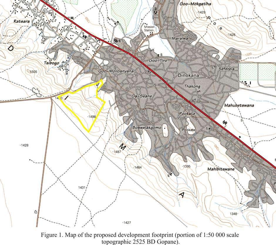
285 5

286 6
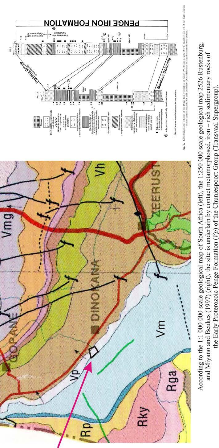
287 7
288 Traffic Impact Statement for the proposed development of a leisure and cultural village on Farm Moila 412-Jo, Dinokana Village, North West Province Compiled by: Surina Laurie (CSIR) Tel: Date: 19 December 2017
289 Contents TRAFFIC IMPACT STATEMENT 2 1. INTRODUCTION 2 2. APPROACH AND METHODOLOGY 2 3. AFFECTED ENVIRONMENT 3 4. IDENTIFICATION OF IMPACTS 9 5. ASSESSMENT OF IMPACTS AND IDENTIFICATION OF MANAGEMENT ACTIONS 9 6. TRAFFIC IMPACT STATEMENT 14 TRAFFIC IMPACT STATEMENT pg 1
290 TRAFFIC IMPACT STATEMENT 1. INTRODUCTION Makadima Leisure and Cultural Village is a project proposed by Makadima Leisure and Cultural Village 101 (Pty) Ltd that will be based in Dinokana Village, outside of Zeerust, in Ngaka Modiri District, North West Province. The Makadima Leisure and Cultural Village aims to showcase the culture of different tribes found in the North West Province and is proposed on the Moiloa Farm 412-JO. The farm portion is 85 hectares in extent. The project aims to employ 20 permanent and 50 temporary staff, who will be from the surrounding Dinokana Village. During the Public Participation Process undertaken at the commencement of this project, the South African National Roads Agency (SANRAL) requested that due to the proximity of the proposed development to the N4, a traffic impact study/report should be submitted for consideration. This Traffic Impact Statement (TIS) has been compiled by the CSIR in support of this request. 1.1 Terms of Reference The key issues associated with the construction and operational phases of the project that will be assessed as part of the traffic assessment are: Increase in traffic generation throughout the lifetime of the project; Decrease in air quality; and Increase in road maintenance required. 1.2 Assumptions The assessment has been based on the traffic information available at this stage of the project. 2. APPROACH AND METHODOLOGY 2.1 Objectives Determine the current traffic conditions in sufficient detail so that there is a baseline against which impacts can be identified and measured; Identify potential impacts and cumulative impacts that may occur during the construction and operational phases of development; Determine mitigation and/or management measures which could be implemented to as far as possible reduce the effect of negative impacts and enhance the effect of positive impacts; and Incorporate and address all issues and concerns raised by Interested and Affected Parties (I&APs) and the public (if applicable). 2.2 Methodology The key steps followed in this assessment are: TRAFFIC IMPACT STATEMENT pg 2
291 Review of available desktop information, including the SANRAL National traffic count information, google earth images; and Incorporating the project information received with the desktop information obtained and the determination of appropriate mitigation measures. 3. AFFECTED ENVIRONMENT The location of the project, the main road and the main access road are shown in Figure 1. The proposed project site can be accessed via an existing access road that intersects with a T- intersection with the N4 at (25 26'36.05"S; 25 51'17.58"E). The existing road is ± 12 m wide and has two lanes. The National Road 4 (N4) is routed from Skilpadshek on the Botswana border, past Rustenburg, Pretoria, Witbank and Nelspruit to Kompatiepoort at the border of Mosambique 1. This section of the N4 comprises of two lanes, one lane routes to Zeerust and the opposite lane to the Skilpadshek border. Two traffic counts, available from 2016 SANRAL data show that at point 1651, Bakwena Dinokana, and point 1641, Bakwena Radikhudu, that the Average Daily Traffic (ADT) is 3989 and 1000, and the Annual Average Daily Truck Traffic (ADTT) is 524 and 388, respectively. These points are also shown in Figure 1. A photo plate is included (Photo 1-4) to show the intersection of the N4 with the existing access road and the current condition of the roads. 1 Falkner, John (May 2012). South African Numbered Route Description and Destination Analysis (Report). National Department of Transport. pp TRAFFIC IMPACT STATEMENT pg 3


292 Figure 1. Project locality and existing roads and traffic information available for the site. TRAFFIC IMPACT STATEMENT pg 4


293 Photo 1: Entrance of the site taken from the existing access road Photo 2: Photo showing the typical condition of the existing access road TRAFFIC IMPACT STATEMENT pg 5

294 Photo 3: T-intersection of the access road and the N4, taken in an northern direction Photo 4: Intersection between the N4 and the access road, taken in a southern direction TRAFFIC IMPACT STATEMENT pg 6

295 Photo 14. 5: Photo of the turn-off on the N4 in the direction of Zeerust Photo 14. 6: Photo of the turn-off on the N4 taken in the direction of the Skilpadshek border TRAFFIC IMPACT STATEMENT pg 7
296 3.1 Transport Information Materials and equipment transported to the site comprise of: Building materials (concrete aggregates, cement and gravel); and Construction equipment such as piling rigs and cranes. The general current limitations on road freight transport are: Axle load limitation of 7,7 ton front axle, 9 t on single rear axles; Axle unit limitations are 18 t for dual axle unit and 24 t for 3 axle unit; Gross vehicle mass of 56 t. This means a typical payload of about 30 t; Maximum vehicle length of 22 m for interlink, 18,5 m for horse and trailer and 13,5 m for a single unit; Width limit of 2,6 m; and Height limit 4,3m. Abnormal permits are required for vehicles exceeding these limits. It is however not anticipated that abnormal vehicles would be required for this development. 3.2 Traffic generation The traffic generation estimates detailed below have been provided by the Applicant. During all phases (construction and operation) of the project, traffic will be generated. The highest traffic volumes will be created during the construction phase. This includes activities associated with: Site preparation and transporting the construction materials, and associated infrastructure to the site; and Transportation of employees to and from the site on a daily basis. Construction Phase: During the construction phase, the following is anticipated: The construction period take 5 to 7 months, during this period, it is anticipated that the following will come to site on a daily basis: o o o o o 10 tipper trucks; 2 front end loaders; 2 excavators; 2 graders; and 2 normal vehicles. Based on the above, it is estimated that the number of vehicles trips during the construction phase would be between and These trips would be made over an estimated period of 5 to 7 months. In the worst case, the number of heavy vehicle trips per day for each facility would be in the order of 12 trips. TRAFFIC IMPACT STATEMENT pg 8
297 Operational Phase: During the operational phase, the following is anticipated: Normal daily operations: minimum of 10 to a maximum of 20 normal vehicles; and Special events: minimum of 100 to maximum of 150 normal vehicles. Decommissioning Phase: At this stage, it is not anticipated that the proposed project will cease to be utilised and all infrastructure removed from site therefore, this phase was not considered as part of the TIS. 4. IDENTIFICATION OF IMPACTS The traffic impacts that will be generated by the proposed facility are detailed below. The impacts will largely occur during the construction phase of the project, since this is when the highest amount of traffic will be generated by the proposed facility (refer to Section 3). The impacts identified and further assessed are: 1. Increase in traffic generation. 2. Accidents with pedestrians, animals and other drivers on the surrounding tarred roads. 3. Impact on air quality due to dust generation, noise and release of air pollutants from vehicles and construction equipment. 5. ASSESSMENT OF IMPACTS AND IDENTIFICATION OF MANAGEMENT ACTIONS This section assesses the significance of the impacts identified in Section 4. Appropriate mitigation and management measures to reduce the significance of the negative impacts and promote the positive impacts have been included in the draft EMPr. 5.1 Increase traffic generation As discussed in Section 4 of this report, conventional trucks and conventional heavy vehicles transporting loads will need to come to site to deliver the infrastructure required for the development. At worst, during the construction phase, 12 vehicles would need to come to site daily. The impact of this on the general traffic would be negligible as the additional peak hour traffic would be at most 2 trips. Significance of impacts without mitigation Although the construction phase would have the greatest impact on traffic generated by the proposed development, the increase in traffic will only result in an addition of 2 trips during peak hour traffic (worst case scenario). Based on the traffic counts discussed in Section 3 of this Chapter, the ADT for this area is between 3989 and 1000 (depending on the direction of the traffic) vehicles. The R27 is designed for 1000 units per day and therefore, the additional traffic generated during the construction phase will have a low negative impact. TRAFFIC IMPACT STATEMENT pg 9
298 The operational phase will have a lower traffic generation since only the personnel permanently employed on site and tourists will come daily to site daily. It is not expected that this would exceed 20 rips per day. Although, during special events this amount may increase to up to 150 vehicles. This negative impact would be very low. Proposed mitigation Even though the traffic generated would not be significant, the following requirements should still be met by the developer during the construction and decommissioning phases: Should abnormal loads have to be transported by road to the site, a permit needs to be obtained. Ensure that roadworthy and safety standards are implemented at all time for all construction vehicles; and Plan trips so that it occurs during the day but avoid construction vehicles movement on the N4 during peak time (06:00-10:00 and 16:00-20:00); A speed limit of 60 km/h should be maintained on the N4. Requirements to be met during the operational phase: Ensure that where possible, staff members carpool to site. 5.2 Accidents with pedestrians, animals and other drivers on the surrounding tarred/gravel roads. During all phases of this project, vehicles will need to access the site. There is the potential that should vehicles not indicate soon enough that they are turning off from the N4, an accident can occur. In addition, not adhering to the relevant speed limits may cause accidents with other drivers and collisions with animals. Significance of impacts without mitigation The significance of causing an accident with pedestrians, animals and other drivers would have a high negative impact significance since the probability of the impact occurring would be highly probable and could be fatal and therefore would cause irreplaceable loss. Proposed mitigation Adhere to speed limits applicable to all roads used; and Implement clear and visible signalisation indicating movement of vehicles and when turning off or onto the N4 and the existing access road to ensure safe entry and exit. Significance of impact with mitigation By implementing the abovementioned mitigation measures the probability of the impact occurring would be lowered significantly which would reduce the significance of the impact to medium negative impact. 5.3 Impact on air quality due to dust generation, noise and release of air pollutants from vehicles and construction equipment Nature of the impact During all the phases of the project, there will be a decrease in air quality due to the noise created by and pollutants released from vehicles coming to site during all phases of the projects, construction activities TRAFFIC IMPACT STATEMENT pg 10
299 occurring on site and dust created. Since the site is located in a rural setting, the extent of the impact would remain local. Significance of impacts without mitigation As discussed above, the decrease in air quality would be local in extent. The worst case scenario for impacts on air quality is that that construction activities occur throughout very windy conditions and during the night-time. This negative impact would be medium, without mitigation. Proposed mitigation Implement management strategies for dust generation e.g. apply dust suppressant on exposed areas and stockpiles; Postpone or reduce dust-generating activities during periods with strong wind; Limit noisy maintenance/operational activities to daytime only; Earthworks may need to be rescheduled or the frequency of application of dust control/suppressant increased; Ensure that all construction vehicles are roadworthy and respect the vehicle safety standards implemented by the Applicant; and Avoid using old and noisy construction equipment and ensure equipment is well maintained. Significance of impact with mitigation With the implementation of the mitigation measures detailed above, the probability of noise emissions and dust realised would be lowered and the impact would be of a low significance. 5.4 Cumulative impact of traffic generation At this stage, it is not known that any similar developments are proposed within the area and the addition of the traffic generated by this project is not deemed to be significant (as outlined within this Section of the TIS). Significance of cumulative impacts It is assumed that the mitigation measures discussed in this Section 5 of this TIS and included in Table 1 below are implemented, that the traffic generation impacts would be suitably managed to ensure that the impacts are suitably managed. Based on this, the cumulative negative impact is low. TRAFFIC IMPACT STATEMENT pg 11
300 Aspect/Impact Pathway Nature of impact Status Spatial Extent Duration Consequence Probability Reversibility Irreplaceability Aspect/Impact Pathway Nature of impact Status Spatial Extent Duration Consequence Probability Reversibility Irreplaceability Table Traffic Impact Assessment Table Significance of Impact/Risk = Consequence x Probability Mitigation Measures Without Mitigation With Mitigation Ranking o Impact/ Risk Confidence Level CONSTRUCTION AND DECOMMISSIONING PHASES Should abnormal loads have to be transported by road to the site, a permit needs to be obtained. Increase in traffic Negative Regional Short term Moderate Very likely Yes Replaceable Ensure that roadworthy and safety standards are implemented at all time for all construction vehicles; and Plan trips so that it occurs during the day but avoid construction vehicles movement on the N4 during peak time (06:00-10:00 and 16:00-20:00); Low Low 4 Medium A speed limit of 60 km/h should be maintained on the N4. Adhere to speed limits applicable to all roads used; and Traffic generation Accidents with pedestrians, animals and other drivers on the surrounding tarred/gravel roads Negative Local Long term Extreme Likely No High irreplaceability Implement clear and visible signalisation indicating movement of vehicles and when turning off or onto the N4 and the existing access road to ensure safe entry and exit. High Moderate 3 Medium Implement management strategies for dust generation e.g. apply dust suppressant on exposed areas and stockpiles; Impact on air quality due to dust generation, noise and release of air pollutants from vehicles and construction equipment Negative Local Medium term Moderate Unlikely Yes Replaceable Postpone or reduce dust-generating activities during periods with strong wind; Limit noisy maintenance/operational activities to daytime only; Earthworks may need to be rescheduled or the frequency of application of dust control/suppressant increased; Ensure that all construction vehicles are roadworthy and respect the vehicle safety standards implemented by the Applicant; and Moderate Low 4 Medium Avoid using old and noisy construction equipment and ensure equipment is well maintained. Significance of Impact/Risk = Consequence x Probability Mitigation Measures Ranking o Impact/ Risk Confidence Level Without Mitigation With Mitigation OPERATIONAL PHASE TRAFFIC IMPACT STATEMENT pg 12
301 Increase in traffic Negative Regional Short term Slight Very likely High Replaceable Ensure that roadworthy and safety standards are implemented at all time for all construction vehicles; and Plan trips so that it occurs during the day but avoid construction vehicles movement on the N4 during peak time (06:00-10:00 and 16:00-20:00); Very low Very low 5 Medium A speed limit of 60 km/h should be maintained on the N4. Traffic generation Accidents with pedestrians, animals and other drivers on the surrounding tarred/gravel roads Negative Local Long term Extreme Likely No High irreplaceability Adhere to speed limits applicable to all roads used; and Implement clear and visible signalisation indicating movement of vehicles and when turning off or onto the N4 and the existing access road to ensure safe entry and exit. High Moderate 3 Medium Implement management strategies for dust generation e.g. apply dust suppressant on exposed areas and stockpiles; Impact on air quality due to dust generation, noise and release of air pollutants from vehicles and construction equipment Negative Local Medium term Moderate Unlikely Yes Replaceable Postpone or reduce dust-generating activities during periods with strong wind; Limit noisy maintenance/operational activities to daytime only; Earthworks may need to be rescheduled or the frequency of application of dust control/suppressant increased; Ensure that all construction vehicles are roadworthy and respect the vehicle safety standards implemented by the Applicant; and Moderate Low 4 Medium Avoid using old and noisy construction equipment and ensure equipment is well maintained. CUMULATIVE IMPACTS Traffic generation Increase in traffic Negative Regional Long term Moderate Very likely High Replaceable n/a Low Low 4 Medium TRAFFIC IMPACT STATEMENT pg 13
302 6. TRAFFIC IMPACT STATEMENT Based on the assessment of the potential impacts that can be associated with the traffic to be generated during the construction and operation the project, the overall impact from traffic generation is deemed to be low when implementing suitable mitigation measures, discussed in Section 4 of this Statement. The highest traffic will be generated during the construction phase. The measures included within the EMPr must be adhered to, with the main requirements outlined below: Should abnormal loads have to be transported by road to the site, a permit needs to be obtained. Ensure that roadworthy and safety standards are implemented at all time for all construction. Adhere to all speed limits applicable to all roads used. Implement clear and visible signalisation indicating movement of vehicles and when turning off or onto the roads to ensure safe entry and exit. Implement management strategies for dust generation e.g. apply dust suppressant on the exposed areas and stockpiles. TRAFFIC IMPACT STATEMENT pg 14
303 A P P E N D I C E S DRAFT BASIC ASSESSMENT REPORT PROPOSED DEVELOP MENT OF LEISURE AND CU LT U RAL VILLAGE ON FARM MOILOA 412 -JO, DINOKANA VILLAGE, NO R TH W EST. Appendix H, Page 1
304 A P P E N D I C E S DRAFT BASIC ASSESSMENT REPORT PROPOSED DEVELOP MENT OF LEISURE AND CU LT U RAL VILLAGE ON FARM MOILOA 412 -JO, DINOKANA VILLAGE, NORTH W EST. Nature of the Potential Impact/Risk Status Spatial Extent Duration Intensity Probability Significance of Impact/Risk (Without Mitigation) Reversibility Irreplaceability Confidence level Can the Impact/Risk be Avoided? Can the Impact/Risk be Mitigated/ Managed? Potential Mitigation Measures Significance of Residual Impact/Risk (With Mitigation) CONSTRUCTION PHASE Direct loss of wetlands Negative Regional Permanent Very high Definite Fatally Flawed Low High 3 Yes Yes Demarcate the construction site and ensure that all activities are carried out within that area. Additionally mark out the wetland on the ground to ensure activities stay out of it. Medium Do not build any infrastructure upstream of the Eye. Contamination of surface and groundwater resources Avoid construction within the "no building zone" as indicated on the proposed infrastructure map. Negative Local Temporary Very high Probable High Low High 3 No Yes Highlight all prohibited activities (e.g. Mixing of concrete in wetland areas littering, cutting of large trees, using the wetland as an ablution development) to workers through training and sign notices. Do not make use of fertilisers, pesticides or herbicides on site especially upstream of the Eye. High Moderate Moderate 3 Yes Yes Limit vehicles, people and materials to the construction site. Commence (and preferably complete) construction during winter, when the risk of erosion should be least. Revegetate denude areas with locally indigenous flora a.s.a.p. Implement erosion protection measures on site. Measures could include bunding around soil stockpiles, and vegetation of areas not to be developed. Implement effective and environmentally-friendly dust control measures, such as mulching or periodic wetting. Increased dust and erosion Negative Local Long term High Highly probable Increased sediment loads Negative Regional Short term Medium Highly probable Increased flood peaks Negative Regional Long term Medium Highly probable Medium Low Moderate 3 Yes Yes Commence (and preferably complete) construction activities during winter when the risk of erosion and wetland sedimentation is lowest. Keep all construction activities to within the demarcated footprint areas (keep out of wetland). Keep cleared areas to a minimum by constructing one development at a time. Revegetate remaining cleared areas by planting indigenous grasses and other vegetation as soon as possible. Do not stockpile soil in the catchment area above the Eye or within the delineated wetland areas. Design measures to effectively control vehicle access, vehicle speed, dust, stormwater run-off, erosion and sedimentation on the road. Medium Moderate Moderate 3 Yes Yes Rehabilitate the head cut erosion within HGM Unit 2 (just upstream of the Eye outside the DWS fence) by stabilising the channel banks. This may be achieved by filling and levelling the channel to remove the drop which creates the erosive vortex Low Low Low Low Appendix H, Page 2
305 A P P E N D I C E S DRAFT BASIC ASSESSMENT REPORT PROPOSED DEVELOP MENT OF LEISURE AND CU LT U RAL VILLAGE ON FARM MOILOA 412 -JO, DINOKANA VILLAGE, NORTH W EST. Nature of the Potential Impact/Risk Status Spatial Extent Duration Intensity Probability Decreased water inputs Negative Regional Short term High Highly probable Clearing of (especially riparian) vegetation and faunal habitats Introduction and establishment of alien species Negative Site- Specific Significance of Impact/Risk (Without Mitigation) Reversibility Irreplaceability Confidence level Can the Impact/Risk be Avoided? Can the Impact/Risk be Mitigated/ Managed? Potential Mitigation Measures during rainfall events. Start with coarser material (e.g. rock) deeper down and progress to finer sands and topsoils towards the surface. Thereafter employ temporary flow attenuation structures such as branches and rows of small hessian bags across the channel filled with grass and sand held in place by thin logs pegged in place with wooden stakes. Preferably prohibit or otherwise monitor the levels of livestock grazing to avoid the overutilisation of the grass sward. Make sure that the access road is well cambered with enough drainage berms to prevent erosion. Minimise the extent of cleared ground and hardened surfaces. Medium Moderate High 3 Yes Yes Do not sink boreholes for the development upstream of the Eye or within 100 m of the delineated wetlands. Permanent High Definite High Low Moderate 3 No Yes Do not clear any riparian vegetation for the development. This is the vegetation occurring within the delineated wetland boundaries. Additionally wherever possible minimise the disturbance to vegetation within the prescribed wetland buffer zones. Modify the layout of planned infrastructure to avoid important floral communities and large indigenous trees. Avoid construction of infrastructure within the NSS infrastructure map demarcated as "no building zone". Integrate the planned infrastructure into the surrounding environment (blending in). Identify and mark indigenous trees on the ground. Those that are small and cannot be avoided should be transplanted elsewhere on site. Demarcate or fence in the construction site. Highlight all prohibited activities to workers through training and notices. Commence (and preferably complete) construction activities during winter, when the risk of disturbing growing plants should be least. Briefly and effectively stockpile topsoil preferably 1-1.5m in height. Use the topsoil to allow natural vegetation to establish in disturbed areas. If recovery is slow, then a seed mix for the area (using indigenous grass species listed within this report) should be sourced and planted. Do not undertake any landscaping with alien flora. Negative Local Permanent High Definite High Moderate High 3 No Yes Demarcate or fence in the construction site. Carefully limit / regulate access by vehicles and materials to the construction site. Prohibit further introduction of domestic animals such as cattle, goats, horses, donkeys, chickens, dogs and cats. Keep construction activities neat and tidy. When complete, remove all sand piles, and Significance of Residual Impact/Risk (With Mitigation) Low Medium Low Appendix H, Page 3
306 A P P E N D I C E S DRAFT BASIC ASSESSMENT REPORT PROPOSED DEVELOP MENT OF LEISURE AND CU LT U RAL VILLAGE ON FARM MOILOA 412 -JO, DINOKANA VILLAGE, NORTH W EST. Nature of the Potential Impact/Risk Status Spatial Extent Duration Intensity Probability Loss of CI or medicinal flora Negative Local Permanent High Highly probable Sensory disturbance of fauna Negative Local Short term Medium Highly probable Significance of Impact/Risk (Without Mitigation) Reversibility Irreplaceability Confidence level Can the Impact/Risk be Avoided? Can the Impact/Risk be Mitigated/ Managed? Potential Mitigation Measures landscape all uneven ground while re-establishing a good topsoil layer. Plant only locally indigenous flora if landscaping needs to be done. Remove Category species using mechanical methods, and minimize soil disturbance as far as possible. Alien wood could be donated to the surrounding community. High Low Moderate 3 No Yes Obtain permits to remove CI species. Transplant CI and medicinally important floral specimens from the infrastructure footprint to suitable and safe locations elsewhere on site or nearby. Obtain guidance from a suitably qualified vegetation specialist or horticulturist regarding the collection, propagation/storage and transplantation of plants. Highlight all prohibited activities to workers through training and notices. Prohibit harvesting of CI and medicinal flora on site by community members through notices and site access control (e.g. fencing). Medium Moderate Moderate 3 No Yes Commence (and preferably complete) construction during winter, when the risk of disturbing active (including breeding and migratory) animals, should be least. Minimize noise to limit its impact on calling and other sensitive fauna (e.g. frogs). Limit construction activities to day time hours. Minimize or eliminate security and construction lighting, to reduce the disturbance of nocturnal fauna. Loss of CI fauna Negative Local Local High Probable Medium Moderate Moderate 3 No Yes Appoint an appropriate specialist to relocate CI fauna from rocky areas, water, termitaria, trees and soil that will be disturbed. Commence (and preferably complete) construction during winter, when the risk of disturbing active (including breeding and migratory) animals, should be least. Check open trenches for trapped animals (e.g. reptiles, frogs and small terrestrial mammals), and relocate trapped animals with advice from an appropriate specialist. Educate workers about dangerous animals (e.g. snakes, scorpions, bees) and highlight all prohibited activities to workers through training and notices. Prohibit harvesting of CI and other indigenous fauna on site by community members through notices and site access control (e.g. fencing). Altered burning Negative Local Local Medium Highly probable Medium Moderate Moderate 3 No Yes Create safe storage on the premises for flammable materials. If artificial burning is considered necessary, establish and implement a fire management plan with emergency fire procedures. Maintain an effective fire break between the development and the surrounding natural Significance of Residual Impact/Risk (With Mitigation) Low Low Low Low Appendix H, Page 4
307 A P P E N D I C E S DRAFT BASIC ASSESSMENT REPORT PROPOSED DEVELOP MENT OF LEISURE AND CU LT U RAL VILLAGE ON FARM MOILOA 412 -JO, DINOKANA VILLAGE, NORTH W EST. Nature of the Potential Impact/Risk Destruction of archaeological artefacts Destruction of palaeontological material Status Negative Negative Spatial Extent Site- Specific Mediumlow Site- Specific Duration Intensity Probability Permanent Permanent Mediumlow Significance of Impact/Risk (Without Mitigation) Reversibility Irreplaceability Confidence level Can the Impact/Risk be Avoided? Can the Impact/Risk be Mitigated/ Managed? Potential Mitigation Measures environment. Ensure that there are appropriate control measures in place for any accidental fires. Educate workers about the fire plan and emergency procedures with regular training and notices. Definite Very low Low High 5 No No If any archaeological material, palaeontological material or human burials are uncovered during the course of development then work in the immediate area should be halted. The find would need to be reported to the heritage authorities and may require inspection by an appropriate specialist. Such heritage is the property of the state and may require excavation and curation in an approved institution. Probable Very low Low High 5 No No If any archaeological material, palaeontological material or human burials are uncovered during the course of development then work in the immediate area should be halted. The find would need to be reported to the heritage authorities and may require inspection by an appropriate specialist. Such heritage is the property of the state and may require excavation and curation in an approved institution. Increase in traffic Negative Regional Short term Medium Very likely Low High Low 3 No Yes Should abnormal loads have to be transported by road to the site, a permit needs to be obtained. Ensure that roadworthy and safety standards are implemented at all time for all construction vehicles; and Plan trips so that it occurs during the day but avoid construction vehicles movement on the N4 during peak time (06:00-10:00 and 16:00-20:00); A speed limit of 60 km/h should be maintained on the N4 Accidents with pedestrians, animals and other drivers on the surrounding tarred/gravel roads Emissions from dust generation and construction vehicles Negative Local Long term Extreme Likely High Low High No Yes Adhere to speed limits applicable to all roads used; and Implement clear and visible signalisation indicating movement of vehicles and when turning off or onto the N4 and the existing access road to ensure safe entry and exit. Negative Local Short term Mediumlow Highly probable Medium Moderate Low 2 No Yes Ensure that cleared (excavated) areas and unpaved surfaces are sprayed with water (obtained from an approved source) to minimise dust generation. Approved soil stabilisers may be utilised to limit dust generation. Ensure that construction vehicles travelling on unpaved roads do not exceed a speed limit of 40 km/hour. Limit vehicles, people and materials to the construction site Adequate dust control strategies should be applied to minimise dust deposition, for example: Periodic spraying of water on the entrance road when necessary Commence (and preferably complete) construction during winter, when the risk of disturbing active (including breeding and migratory) animals, should be least. Significance of Residual Impact/Risk (With Mitigation) Very low Very low Low Medium Low Appendix H, Page 5
308 A P P E N D I C E S DRAFT BASIC ASSESSMENT REPORT PROPOSED DEVELOP MENT OF LEISURE AND CU LT U RAL VILLAGE ON FARM MOILOA 412 -JO, DINOKANA VILLAGE, NORTH W EST. Nature of the Potential Impact/Risk Opportunities for employment and skills development Potential visual impacts as the result of construction activities Potential noise impact as the result of the use of construction equipment Potential impact on the safety of construction workers and Health injuries to construction personnel as a result of construction work Status Spatial Extent Duration Intensity Probability Significance of Impact/Risk (Without Mitigation) Reversibility Irreplaceability Confidence level Can the Impact/Risk be Avoided? Can the Impact/Risk be Mitigated/ Managed? Potential Mitigation Measures Noise should also be minimised throughout construction to limit the impact on sensitive fauna such as owls and large terrestrial birds. Limit construction activities to day time hours Positive Local Long term Medium Probable Medium High High 3 No Ye Enhance the use of local labour and local skills as far as reasonably possible. Where the required skills do not occur locally, and where appropriate and applicable, ensure that relevant local individuals are trained. Ensure that an equitable percentage allocation is provided for local labour employment as well as specify the use of small-to-medium enterprises and training specifications in the Contractors contract. Ensure that goods and services are sourced from the local and regional economy as far as reasonably possible. Negative Local Short term Mediumlow Negative Negative Local Short term Mediumlow Sitespecific Significance of Residual Impact/Risk (With Mitigation) Probable Low High High 3 Yes Yes No specific mitigation measures are required other Low than standard construction site housekeeping and dust suppression. These are included below: - The contractor(s) should maintain good housekeeping on site to avoid litter and minimise waste. - Litter and rubble should be timeously removed from the construction site and disposed at a licenced waste disposal facility. - The project developer should demarcate construction boundaries and minimise areas of surface disturbance. - Appropriate plans should be in place to minimise fire hazards and dust generation. Night lighting of the construction site should be minimised within requirements of safety and efficiency. Probable Medium Moderate High 3 No Yes Limit construction activities to day time hours Low Short term Low Improbable Medium High High 3 Yes Yes Ensure that a skilled and competent Contractor is appointed during the construction phase. The Contractor must be evaluated during the tender/appointment process in terms of safety standards. The Contractor must ensure that all construction personnel are provided with adequate PPE for use where appropriate. The Contractor must undertake a Construction Phase Risk Assessment. A Construction Site Manager or Safety Supervisor should be appointed, in conjunction with the project manager, to monitor all safety aspects during the construction phase. This could be the same person that is assigned to co-ordinate the construction traffic. Ensure that roads are not closed during construction, which may restrict access for emergency services. High Medium Appendix H, Page 6
309 A P P E N D I C E S DRAFT BASIC ASSESSMENT REPORT PROPOSED DEVELOP MENT OF LEISURE AND CU LT U RAL VILLAGE ON FARM MOILOA 412 -JO, DINOKANA VILLAGE, NORTH W EST. Nature of the Potential Impact/Risk OPERATION PHASE Further loss / degradation of wetlands Contamination of surface and groundwater resources Status Spatial Extent Duration Intensity Probability Significance of Impact/Risk (Without Mitigation) Reversibility Irreplaceability Confidence level Can the Impact/Risk be Avoided? Can the Impact/Risk be Mitigated/ Managed? Potential Mitigation Measures The Contractor must ensure that all construction personnel are provided with adequate PPE for use where appropriate. Negative Regional Permanent High High High Moderate High 3 Yes Yes Monitor the success of the rehabilitated erosion gully in HGM Unit 2 Keep future developments outside of the delineated wetland areas and associated buffers. Negative Regional Permanent High High High Low High 3 No Yes Ensure that all waste water (sewerage and grey water) is contained in properly lined septic tanks. Which are serviced regularly. Do not make use of french drains or long drops. Minimise sinkhole formation by regularly inspect all water pipelines and thoroughly mend any leaks as soon as they arise. Ensure that the development is run in accordance with international best practice norms, and with advice from an appropriate specialist, to ensure that there is no environmental contamination from effluent, fodder, carcasses and other waste, and to ensure that there is also effective storm water management. Signpost the site especially the picnic area with all prohibited activities which should include (amongst others) no littering, no wood collecting, no abluting in the stream or bush, no making of fires except within the braai areas. All hazardous waste should be disposed of at an appropriate licensed facility for this. Waste recycling should be incorporated into the development s operations as far as possible. Educate workers about the development's waste management and handling of hazardous substances with regular training and notices. Decreased water inputs Negative Regional Long term Medium Probable Medium Moderate Moderate 3 No Yes Diligently monitor and measure water usage in measurable Units. Keep a spreadsheet and compare data to DWS flow rates for the Dinokana Eye on an annual basis. Reduce water usage wherever possible. Put up signs in the accommodation encouraging visitors to spare water and re-use laundry during their stay if not too dirty. Investigate the possibility of capturing rainwater. Continued introduction and proliferation of alien species Negative Local Long term High Definite High Moderate High 3 No Yes Carefully limit / regulate access by vehicles and materials to the site. Prohibit further introduction of domestic animals such as cattle, goats, horses, donkeys, chickens, dogs and cats. Employ best practices regarding tilling of soil and weed management. Plant only locally indigenous flora if landscaping needs to be done. Remove Category species using mechanical methods, and minimize soil disturbance as far as Significance of Residual Impact/Risk (With Mitigation) Medium Low Medium Low Appendix H, Page 7
310 A P P E N D I C E S DRAFT BASIC ASSESSMENT REPORT PROPOSED DEVELOP MENT OF LEISURE AND CU LT U RAL VILLAGE ON FARM MOILOA 412 -JO, DINOKANA VILLAGE, NORTH W EST. Nature of the Potential Impact/Risk Status Spatial Extent Duration Intensity Probability Loss of CI or medicinal flora Negative Local Permanent High Highly probable Sensory disturbance of fauna Negative Local Long term High Highly probable Significance of Impact/Risk (Without Mitigation) Reversibility Irreplaceability Confidence level Can the Impact/Risk be Avoided? Can the Impact/Risk be Mitigated/ Managed? Potential Mitigation Measures possible. Alien wood could be donated to the surrounding community. High Low Moderate 3 No Yes Highlight all prohibited activities to workers through training and notices. Prohibit harvesting of CI and medicinal flora on site by community members through notices and site access control (e.g. fencing). High Moderate Moderate 3 No Yes Install motion-sensitive lights. Ensure that all outdoor lights are angled downwards and/or fitted with hoods. Use bulbs that emit warm, long wavelength (yellowred) light, or use UV filters or glass housings on lamps to filter out UV. Avoid using metal halide, mercury or other bulbs that emit high UV (blue-white) light that is highly and usually fatally attractive to insects. Conduct regular maintenance of machinery, fans and other noisy equipment. Encourage workers to minimize light and noise pollution through training and notices. Loss of CI fauna Negative Local Permanent High Probable Medium Moderate Moderate 3 No Yes Educate workers about dangerous animals (e.g. snakes, scorpions, bees) and highlight all prohibited activities to workers through training and notices. Prohibit harvesting of CI and other indigenous fauna on site by community members through notices and site access control (e.g. fencing). Erosion Negative Local Long term High Highly probable Altered burning Negative Local Long term Medium Highly probable High Moderate Moderate 3 No Yes Limit vehicles and people to the development footprint. Revegetate denude areas with locally indigenous flora a.s.a.p. Implement erosion protection measures on site. Measures could include bunding around soil stockpiles, and vegetation of areas not to be developed. Medium Moderate Moderate 3 No Yes Create safe storage on the premises for flammable materials. If artificial burning is considered necessary, establish and implement a fire management plan with emergency fire procedures. Maintain an effective fire break between the development and the surrounding natural environment. Ensure that there are appropriate control measures in place for any accidental fires. Educate workers about the fire plan and emergency procedures with regular training and notices. Increase in traffic Negative Regional Short-term Low Very likely Very low High Moderate 3 No Yes Ensure that roadworthy and safety standards are implemented at all time for all construction vehicles; and Plan trips so that it occurs during the day but avoid construction vehicles movement on the N4 during peak time (06:00-10:00 and 16:00-20:00); A speed limit of 60 km/h should be maintained on the N4. Significance of Residual Impact/Risk (With Mitigation) Low Medium Low Low Low Very low Appendix H, Page 8
311 A P P E N D I C E S DRAFT BASIC ASSESSMENT REPORT PROPOSED DEVELOP MENT OF LEISURE AND CU LT U RAL VILLAGE ON FARM MOILOA 412 -JO, DINOKANA VILLAGE, NORTH W EST. Nature of the Potential Impact/Risk Accidents with pedestrians, animals and other drivers on the surrounding tarred/gravel roads Impact on air quality due to dust generation, noise and release of air pollutants from vehicles and construction equipment Destruction of archaeological artefacts Destruction of palaeontological material Opportunities for employment and skills development Night lighting of the development on the nightscape of the surrounding landscape Status Spatial Extent Duration Intensity Probability Significance of Impact/Risk (Without Mitigation) Reversibility Irreplaceability Confidence level Can the Impact/Risk be Avoided? Can the Impact/Risk be Mitigated/ Managed? Potential Mitigation Measures Negative Local Long term High Likely High Low High 3 No Yes Adhere to speed limits applicable to all roads used; and Implement clear and visible signalisation indicating movement of vehicles and when turning off or onto the N4 and the existing access road to ensure safe entry and exit. Negative Negative Local Site- Specific Mediumlow Site- Specific Medium term Permanent Permanent Medium Unlikely Medium High Moderate 3 No Yes Implement management strategies for dust generation e.g. apply dust suppressant on exposed areas and stockpiles; Postpone or reduce dust-generating activities during periods with strong wind; Limit noisy maintenance/operational activities to daytime only; Earthworks may need to be rescheduled or the frequency of application of dust control/suppressant increased; Ensure that all construction vehicles are roadworthy and respect the vehicle safety standards implemented by the Applicant; and Avoid using old and noisy construction equipment and ensure equipment is well maintained. Mediumlow Definite Very low Low High 5 No No If any archaeological material, palaeontological material or human burials are uncovered during the course of development then work in the immediate area should be halted. The find would need to be reported to the heritage authorities and may require inspection by an appropriate specialist. Such heritage is the property of the state and may require excavation and curation in an approved institution. Probable Very low Low High 5 No No If any archaeological material, palaeontological material or human burials are uncovered during the course of development then work in the immediate area should be halted. The find would need to be reported to the heritage authorities and may require inspection by an appropriate specialist. Such heritage is the property of the state and may require excavation and curation in an approved institution. Positive Local Long term Medium Probable Medium High High 3 No Yes Enhance the use of local labour and local skills as far as reasonably possible. Where the required skills do not occur locally, and where appropriate and applicable, ensure that relevant local individuals are trained Ensure that an equitable percentage allocation is provided for local labour employment as well as specify the use of small-to-medium enterprises and training specifications in the Contractors contract. Negative Local Long term Medium Highly probable Low Moderate Low 3 Yes No No specific mitigation measures are recommended as it is assumed that night lighting of the proposed storage facility will be planned in such a manner so as to minimize light pollution such as glare and light spill (light trespass) by: Using light fixtures that shield the light and focus illumination on the ground (or only where light is required). Avoiding elevated lights within safety/security Significance of Residual Impact/Risk (With Mitigation) Medium Low Very low Very low High Low Appendix H, Page 9
312 A P P E N D I C E S DRAFT BASIC ASSESSMENT REPORT PROPOSED DEVELOP MENT OF LEISURE AND CU LT U RAL VILLAGE ON FARM MOILOA 412 -JO, DINOKANA VILLAGE, NORTH W EST. Nature of the Potential Impact/Risk Minor accidents to the public and moderate accidents to operational staff DECOMMISSIONING PHASE Further loss/degradation of wetlands Contamination of surface and groundwater resources Status Spatial Extent Duration Intensity Probability Negative Local Long term Mediumlow Negative Regional Permanent High Highly probable Negative Regional Permanent High Highly probable Increased dust and erosion Negative Local Long term High Highly probable Significance of Impact/Risk (Without Mitigation) Reversibility Irreplaceability Confidence level Can the Impact/Risk be Avoided? Can the Impact/Risk be Mitigated/ Managed? Potential Mitigation Measures requirements. Using minimum lamp wattage within safety/security requirements. Where possible, using timer switches or motion detectors to control lighting in areas that are not occupied continuously (if permissible and in line with minimum security requirements). Switching off lights when not in use in line with safety and security. Improbable Medium Moderate High 3 Yes Yes An Emergency Plan should be compiled in order to deal with potential spillages and fires. Records of practices should be kept on site. Scheduled inspections should be implemented by operating personnel in order to assure and verify the integrity of hoses, piping and storage lagoon. Portable fire extinguishers and fire water hydrants (i.e. appropriate fire-fighting equipment) should be provided at the facility as required. High Moderate High 3 No Yes Keep decommissioning activities outside of the delineated wetland areas and associated buffers. Demarcate the decommissioning site and ensure that all activities are carried out within that area. Additionally mark out the wetland on the ground to ensure activities stay out of it. Avoid disturbing the "no building zone". High Low High 3 No Yes *Do not make use of french drains or long drops. Minimise sinkhole formation by sealing or otherwise inspecting water pipelines and thoroughly mend any leaks. Ensure that storm water management remains effective during and following decommissioning. All grey water, sewage and other hazardous waste should be disposed of at an appropriate licensed facility for this. Waste recycling should be incorporated into decommissioning as far as possible. Educate workers about the development's waste management and handling of hazardous substances with regular training and notices. High Low Moderate 3 No Yes Limit vehicles, people and materials to the decommissioning site. Commence (and preferably complete) decommissioning during winter, when the risk of erosion should be least. Revegetate denude areas with locally indigenous flora a.s.a.p. Implement erosion protection measures on site. Measures could include bunding around soil stockpiles, and vegetation of areas not to be developed. Implement effective and environmentally-friendly dust control measures, such as mulching or periodic Significance of Residual Impact/Risk (With Mitigation) Low Medium Low Low Appendix H, Page 10
313 A P P E N D I C E S DRAFT BASIC ASSESSMENT REPORT PROPOSED DEVELOP MENT OF LEISURE AND CU LT U RAL VILLAGE ON FARM MOILOA 412 -JO, DINOKANA VILLAGE, NORTH W EST. Nature of the Potential Impact/Risk Status Spatial Extent Duration Intensity Probability Significance of Impact/Risk (Without Mitigation) Reversibility Irreplaceability Confidence level Can the Impact/Risk be Avoided? Can the Impact/Risk be Mitigated/ Managed? wetting. Potential Mitigation Measures Significance of Residual Impact/Risk (With Mitigation) Increased sediment loads Negative Regional Short term Medium Highly probable Continued proliferation of alien species Medium Moderate Moderate 3 No Yes Commence (and preferably complete) decommissioning activities during winter when the risk of erosion and wetland sedimentation is lowest. Keep all decommissioning activities to within the demarcated footprint areas (keep out of wetland). Keep cleared areas to a minimum by demolishing one development section at a time. Revegetate remaining cleared areas by planting indigenous grasses and other vegetation as soon as possible. Do not stockpile soil in the catchment area above the Eye or within the delineated wetland areas. Design measures to effectively control vehicle access, vehicle speed, dust, stormwater run-off, erosion and sedimentation on the road. Negative Local Permanent High Definite High Low High 3 No Yes Remove Category species using mechanical methods, and minimize soil disturbance as far as possible. Alien wood could be donated to the surrounding community. Loss of CI or medicinal flora Negative Local Medium High Highly probable Sensory disturbance of fauna Negative Local Long term Medium Highly probable High Moderate Moderate 3 No Yes Highlight all prohibited activities to workers through training and notices. Prohibit harvesting of CI and medicinal flora on site by community members through notices and site access control (e.g. fencing). Medium Moderate Moderate 3 No Yes Conduct regular maintenance of machinery, fans and other noisy equipment. Encourage workers to minimize light and noise pollution through training and notices. Loss of CI fauna Negative Local Medium High Probable Medium Moderate Moderate 3 No Yes Educate workers about dangerous animals (e.g. snakes, scorpions, bees) and highlight all prohibited activities to workers through training and notices. Prohibit harvesting of CI and other indigenous fauna on site by community members through notices and site access control (e.g. fencing). Altered Burning Negative Local Long term Medium Highly probable Medium Moderate Moderate 3 No Yes Create safe storage on the premises for flammable materials. If artificial burning is considered necessary, establish and implement a fire management plan with emergency fire procedures. Maintain an effective fire break between the development and the surrounding natural environment. Ensure that there are appropriate control measures in place for any accidental fires. Educate workers about the fire plan and emergency procedures with regular training and notices. Low Low Low Low Low Low Destruction of archaeological artefacts Negative Site- Specific Permanent Mediumlow Definite Very low Low High 5 No No If any archaeological material, palaeontological material or human burials are uncovered during the course of development then work in the immediate area should be halted. The find would need to be reported to the heritage authorities and may require inspection by an appropriate specialist. Such Very low Appendix H, Page 11
314 A P P E N D I C E S DRAFT BASIC ASSESSMENT REPORT PROPOSED DEVELOP MENT OF LEISURE AND CU LT U RAL VILLAGE ON FARM MOILOA 412 -JO, DINOKANA VILLAGE, NORTH W EST. Nature of the Potential Impact/Risk Status Spatial Extent Duration Intensity Probability Significance of Impact/Risk (Without Mitigation) Reversibility Irreplaceability Confidence level Can the Impact/Risk be Avoided? Can the Impact/Risk be Mitigated/ Managed? Potential Mitigation Measures heritage is the property of the state and may require excavation and curation in an approved institution. Destruction of palaeontological Negative Site- Permanent Mediumlow Probable Very low Low High 5 No No If any archaeological material, palaeontological material Specific material or human burials are uncovered during the course of development then work in the immediate area should be halted. The find would need to be reported to the heritage authorities and may require inspection by an appropriate specialist. Such heritage is the property of the state and may require excavation and curation in an approved institution. Increase in traffic Negative Regional Short term Medium Very likely Low High Low 3 No Yes Should abnormal loads have to be transported by road to the site, a permit needs to be obtained. Ensure that roadworthy and safety standards are implemented at all time for all construction vehicles; and Plan trips so that it occurs during the day but avoid construction vehicles movement on the N4 during peak time (06:00-10:00 and 16:00-20:00); A speed limit of 60 km/h should be maintained on the N4 Accidents with pedestrians, animals and other drivers on the surrounding tarred/gravel roads Pollution of the surrounding environment as a result of the handling, temporary storage and disposal of solid waste Negative Local Long term Extreme Likely High Low High No Yes Adhere to speed limits applicable to all roads used; and Implement clear and visible signalisation indicating movement of vehicles and when turning off or onto the N4 and the existing access road to ensure safe entry and exit. Negative Local Short term Medium Probable Medium High High 3 Yes Yes General waste (i.e. building rubble, demolition waste, discarded concrete, bricks, tiles, wood, glass, plastic, metal, excavated material, packaging material, paper and domestic waste etc.) and hazardous waste (i.e. empty tins, paint and paint cleaning liquids, oils, fuel spillages and chemicals etc.) generated during the decommissioning phase should be stored temporarily on site in suitable (and correctly labelled) waste collection bins and skips (or similar). Waste collection bins and skips should be covered with suitable material, where appropriate. Should the on-site storage of general waste and hazardous waste exceed 100 m3 and 80 m3 respectively, then the National Norms and Standards for the Storage of Waste (published on 29 November 2013 under GN 926) must be adhered to. Ensure that general waste and hazardous waste generated are removed from the site on a regular basis and disposed of at an appropriate, licensed waste disposal facility by an approved waste management Contractor. Waste disposal slips or waybills should be kept on file for auditing purposes as proof of disposal. Ensure that sufficient general waste disposal bins are provided for all personnel throughout the site. These bins must be emptied on a regular basis. Appropriately time demolition / rehabilitation activities to minimise sensory disturbance to fauna. Significance of Residual Impact/Risk (With Mitigation) Very low Low Medium Low Appendix H, Page 12
315 A P P E N D I C E S DRAFT BASIC ASSESSMENT REPORT PROPOSED DEVELOP MENT OF LEISURE AND CU LT U RAL VILLAGE ON FARM MOILOA 412 -JO, DINOKANA VILLAGE, NORTH W EST. Nature of the Potential Impact/Risk Emissions from decommissioning vehicles and generation of dust Noise generation from demolition activities Status Spatial Extent Duration Intensity Probability Negative Site specific Short term Negative Local Short term Mediumlow Mediumlow Highly probable Significance of Impact/Risk (Without Mitigation) Reversibility Irreplaceability Confidence level Can the Impact/Risk be Avoided? Can the Impact/Risk be Mitigated/ Managed? Potential Mitigation Measures Medium Moderate Low 2 No Yes Ensure that cleared (excavated) areas and unpaved surfaces are sprayed with water (obtained from an approved source) to minimise dust generation. Approved soil stabilisers may be utilised to limit dust generation. Ensure that decommissioning vehicles travelling on unpaved roads do not exceed a speed limit of 40 km/hour. Probable Medium Moderate High 3 No Yes A method statement, including detailed procedures, must be drawn up prior to any decommissioning of existing tanks. Decommissioning personnel must wear proper hearing protection, which should be specified as part of the Decommissioning Phase Risk Assessment carried out by the Contractor. The Contractor must ensure that all decommissioning personnel are provided with adequate PPE, where appropriate. Significance of Residual Impact/Risk (With Mitigation) Low Low Appendix H, Page 13
316 A P P E N D I C E S DRAFT BASIC ASSESSMENT REPORT PROPOSED DEVELOP MENT OF A LEISURE AND CUL TURAL VILLAGE ON FARM MOILOA 412 -JO, DINOKANA VILLAGE, NO R TH W EST. Appendix I1: Proof of the placement of the relevant advertisements and notices 2 Appendix I2: Proof that the key stakeholder received written notification of the proposed activities 7 Appendix I3: Comments Received from I&AP 14 Appendix I4: Proof that the Authorities and Organs of State received written notification and draft reports of the proposed activities. Error! Bookmark not defined. Appendix I5: A list of registered Interested and Affected Parties 22 Appendix I, Page 1

317 A P P E N D I C E S Appendix I1: Proof of the placement of the relevant advertisements and notices Proof of newspaper advertisement Appendix I, Page 2

318 A P P E N D I C E S Contents of Newspaper Advertisement Appendix I, Page 3

319 A P P E N D I C E S Proof of Site Notice Appendix I, Page 4

320 A P P E N D I C E S Contents of the Site Notice Appendix I, Page 5

321 A P P E N D I C E S Appendix I, Page 6
322 A P P E N D I C E S Appendix I2: Proof that the key stakeholder received written notification of the proposed activities to I&AP From: Rirhandzu Marivate [RMarivate@csir.co.za] Sent: 28 July :59 AM Subject: NOTICE: Basic Assessment for the Development of a Leisure and Cultural Village on Farm Moiloa 421-JO, Dinokana Village, Ngaka Modiri Molema, North West Dear Interest and/or Affected Party, The Council for Scientific and Industrial Research is currently conducting a Basic Assessment for Makadima Leisure and Cultural Village 101 (Pty) Ltd, who are proposing to develop a leisure and cultural village on Farm Moiloa 412-JO, Dinokana Village, Ngaka Modiri Molema District, North West. The Basic Assessment is conducted through the Special Needs and Skills Development Programme under the National Department of Environmental Affairs. In line with the Environmental Impact Assessment requirements of 7 April 2017, Interested and Affected Parties (I&APs) must be notified and are requested to register for this project in order to receive future correspondence of this project and/or provide comments on issues of concern that will be considered during the Basic Assessment process. Please find attached a Letter of Invitation, a Background Information Document (BID) and a Comment and Registration form. You have until on or before 28 August 2017 to register and submit your comments for this project. Kindest Regards, Rirhandzu Marivate Junior Environmental Scientist Environmental Management Services Implementation Unit CSIR tel: rmarivate@csir.co.za Appendix I, Page 7
323 A P P E N D I C E S Delivery Report amogelang.sefara@moretele.org.za Transferred 25/08/ :44 BC: amogelang.sefara@moretele.org.za andrew.mvundle@gmail.com Transferred 25/08/ :45 BC: andrew.mvundle@gmail.com avanstraaten@nwpg.gov.za Transferred 25/08/ :45 BC: avanstraaten@nwpg.gov.za barbersp@lantic.net Transferred 25/08/ :45 BC: barbersp@lantic.net BotaV@nra.co.za Transferred 25/08/ :45 BC: BotaV@nra.co.za cmmutle@nwpg.gov.za Transferred 25/08/ :45 BC: cmmutle@nwpg.gov.za howard.hendricks@sanparks.org Transferred Transferred Transfer Delayed 25/08/ :44 Transferred 25/08/ :05 BC: howard.hendricks@sanparks.org innocents@bojanala.gov.za Transferred 25/08/ :45 BC: innocents@bojanala.gov.za kgauta.mokoena@dmr.gov.za Transferred 25/08/ :44 BC: kgauta.mokoena@dmr.gov.za lfourie@nwpg.gov.za Transferred 25/08/ :45 BC: lfourie@nwpg.gov.za lmotlhanke@nwpg.gov.za Transferred 25/08/ :45 BC: lmotlhanke@nwpg.gov.za mashuduma@daff.gov.za Transferred 25/08/ :44 BC: mashuduma@daff.gov.za mbila@nwpg.gov.za Transferred 25/08/ :45 BC: mbila@nwpg.gov.za Transferred Transferred Transferred Transferred Transfer Delayed Transferred Transferred Transferred Transferred Transferred Transferred mmadire.rampedi@morepele.org.za Undelivered 421 service unavailable MMolefane@thedti.gov.za Transferred Transferred 25/08/ :45 BC: MMolefane@thedti.gov.za MohapiN@dwa.gov.za Transferred 25/08/ :45 BC: MohapiN@dwa.gov.za mosadim@nwpg.gov.za Transferred 25/08/ :45 Transferred Transferred Appendix I, Page 8
324 A P P E N D I C E S mosadim@nwpg.gov.za BC: mosadim@nwpg.gov.za mosianem@nwpg.gov.za Transferred 25/08/ :45 BC: mosianem@nwpg.gov.za mrabothata@environment.gov.za Transferred 25/08/ :44 BC: mrabothata@environment.gov.za mtumane@nwpg.gov.za Transferred 25/08/ :45 BC: mtumane@nwpg.gov.za MuthraparsadN@dwa.gov.za Transferred 25/08/ :45 BC: MuthraparsadN@dwa.gov.za ncamisile.nkabinde@drdlr.gov.za Transferred 25/08/ :45 BC: ncamisile.nkabinde@drdlr.gov.za ntnango@nwpg.gov.za Undelivered Transferred Undeliverable 25/08/ :45 25/08/ :45 BC: ntnango@nwpg.gov.za okgathea@nwpg.gov.za Transferred 25/08/ :45 BC: okgathea@nwpg.gov.za pkhrisjan@nwpg.gov.za Undelivered rmathebula@nwpg.gov.za Transferred 25/08/ :45 BC: rmathebula@nwpg.gov.za Sfoya@geoscience.org.za Transferred 25/08/ :44 BC: Sfoya@geoscience.org.za SHlela@environment.gov.za Transferred 25/08/ :44 BC: SHlela@environment.gov.za Transferred Transferred Transferred Transferred Transferred Transferred <ntnango@nwpg.gov.za>: Recipient address rejected: undeliverable address: host [ ] said: 550 No such recipient (in reply to RCPT TO command) <ntnango@nwpg.gov.za>: Recipient address rejected: undeliverable address: host [ ] said: 550 No such recipient (in reply to RCPT TO command) Transferred <pkhrisjan@nwpg.gov.za>: Recipient address rejected: undeliverable address: host [ ] said: 550 No such recipient (in reply to RCPT TO command) Transferred Transferred Transferred Appendix I, Page 9
325 A P P E N D I C E S smukhola@nwpg.gov.za Undelivered Transferred Undeliverable 25/08/ :45 25/08/ :45 BC: smukhola@nwpg.gov.za stephaniea@ewt.org.za Transferred 25/08/ :45 BC: stephaniea@ewt.org.za tboshoff@nwpg.gov.za Transferred 25/08/ :45 BC: tboshoff@nwpg.gov.za tmakhoana@salga.org.za Transferred 25/08/ :44 BC: tmakhoana@salga.org.za tnemarude@environment.gov.za Transferred 25/08/ :44 BC: tnemarude@environment.gov.za vincent.maseko@yahoo.com Transferred 25/08/ :45 BC: vincent.maseko@yahoo.com Attachments: User: 3,System: <smukhola@nwpg.gov.za>: Recipient address rejected: undeliverable address: host [ ] said: 550 No such recipient (in reply to RCPT TO command) <smukhola@nwpg.gov.za>: Recipient address rejected: undeliverable address: host [ ] said: 550 No such recipient (in reply to RCPT TO command) Transferred Transferred Transferred Transferred Transferred BID_final.pdf 826 KB ( Bytes) 23/08/ :20 I&APs Cover Letter_Draft_ENGLISH.pdf 336 KB ( Bytes) 25/08/ :35 Register I&APs_Disclosure of interest_english.docx 147 KB ( Bytes) 23/08/ :36 MESSAGE 4 KB (4667 Bytes) 25/08/ :44 TEXT.htm 5 KB (5948 Bytes) 25/08/ :44 Send Options: Appendix I, Page 10

326 A P P E N D I C E S Letter to I&AP Appendix I, Page 11
327 A P P E N D I C E S Proof of Postage Appendix I, Page 12
328 A P P E N D I C E S Appendix I, Page 13
329 A P P E N D I C E S Appendix I3: Comments Received from I&AP Subject: RE: NOTICE: Basic Assessment for the Development of a Leisure and Cultural Village on Farm Moiloa 421-JO, Dinokana Village, Ngaka Modiri Molema, North West Created By: BotaV@nra.co.za Scheduled Date: Creation Date: 28/07/ :55 From: "Victoria Bota (HO)" <BotaV@nra.co.za> Good day Rirhandzu Please that SANRAL might be affected by the proposed project as it will be in close proximity of the National Route N4. Kindly forward us the traffic impact study/report once finalised for our review and comments. Kind regards Ms Victoria Bota Environmental Co-ordinator Tel: Cell: Fax: botav@nra.co.za Northern Region 38 Ida Street Menlo Park Pretoria SANRAL Fraud Hotline: One thing I ask of the LORD, this is what I seek: that I may dwell in the house of the LORD all the days of my life... Appendix I, Page 14
330 A P P E N D I C E S RE: NOTICE: Basic Assessment for the Development of a Leisure and Cultural Village Subject: on Farm Moiloa 421-JO, Dinokana Village, Ngaka Modiri Molema, North West Created By: AckermanP@dws.gov.za Scheduled Date: Creation Date: 28/07/ :53 From: Ackerman Pieter <AckermanP@dws.gov.za> Hi Is any wate ruse authorisation required? Regards Pieter Ackerman (PrLArch) Chief Landscape Architect Department of Water and Sanitation (DWS), South Africa Sub Directorate Instream Water Use Tel: Cell: Fax: Appendix I, Page 15

331 A P P E N D I C E S Appendix I, Page 16

332 A P P E N D I C E S Appendix I, Page 17

333 A P P E N D I C E S Appendix I, Page 18

334 A P P E N D I C E S Appendix I, Page 19
335 A P P E N D I C E S Appendix I, Page 20
336 A P P E N D I C E S Comments and Response Trail Appendix I, Page 21
337 A P P E N D I C E S Appendix I5: A list of registered Interested and Affected Parties Company/organization Name Postal NATIONAL, PROVINCIAL AND LOCAL Department of Environmental Affairs- National Mmatlala Rabothata Fedsure Building, Private Bag X447, 315 Pretorius Street, Pretoria, 0002 Department of Environmental Affairs- National Sibusisiwe Hlela Fedsure Building, Private Bag X447, 315 Pretorius Street,Pretoria 0002 Department of Environmental Affairs- National Takalani Nemarude Fedsure Building, Private Bag X447, 315 Pretorius Street, Pretoria 0002 Department of Rural Development and Land Reform Bonginkosi Zulu Fedsure Building, Private Bag X447, 315 Pretorius Street, Pretoria 0002 Department of Agriculture, Forestry and Fisheries Mashudu Marubini Private Bag X138, Pretoria, 0001 National Department of Mineral Resources Kgauta Mokoena Private Bag X59, Arcadia 0007 National Department of Water Affairs Ms Ndileka K mohapi Private Bag X313,Pretoria, 0001 National Department of Water Affairs Namisha Muthraparsad Private Bag X313,Pretoria, 0001 NW READ Rhuleni Mathebula Private Bag X2039,Mmabatho,2739 NW READ Malefyane Mosadi Private Bag X2039,Mmabatho,2739 Moretele Local Municipality Amogelang Sefara Private Bag X367, Makapanstad, North West, 0404 Moretele Local Municipality Municipal Manager Private Bag X367, Makapanstad, North West, 0404 Bojanala Platinum District Municipality Goitsimosimo Tau P O Box 1993, Rustenburg,0300 LANDOWNERS & NEIGHBOURS Community Chairman- Plot 260 Jonathan Mr Ngema Private Bag X1031 Bethanie, 0270 Neighbouring Landowner- Plot 46 Jonathan Jan Maseko Private Bag X1031 Bethanie, 0271 Appendix I, Page 22
338 A P P E N D I C E S Company/organization Name Postal Neighbouring Landowner- Plot 48 Jonathan Mathews Mlangeni Private Bag X1031 Bethanie, 0272 Neighbouring Landowner- Plot 41 Jonathan David Maseko Private Bag X1031 Bethanie, 0273 Neighbouring Landowner- Plot 274 Jonathan Boysee Masango Private Bag X1031 Bethanie, 0274 Neighbouring Landowner- Plot 48 Jonathan Joshua Mlangeni Private Bag X1031 Bethanie, 0275 Neighbouring Landowner- Plot 61 Jonathan Edwin Lelaka Private Bag X1031 Bethanie, 0276 Neighbouring Landowner- Plot 35 Jonathan Senza Ngozo Private Bag X1031 Bethanie, 0277 Neighbouring Landowner- Plot 46 Jonathan Alfred Ngobese Private Bag X1031 Bethanie, 0278 Neighbouring Landowner- Plot 46 Jonathan Madoda Maseko Private Bag X1031 Bethanie, 0279 Neighbouring Landowner- Plot 48 Jonathan Sbongseni Mlangeni Private Bag X1031 Bethanie, 0280 Neighbouring Landowner- Plot 35 Jonathan Mndeni Ngozo Private Bag X1031 Bethanie, 0281 Neighbouring Landowner- Plot 232 Jonathan Bongane Radebe Private Bag X1031 Bethanie, 0282 Ward Councillor Mr. Mosetlhe P O Box 1962, Hammanskraal, 0400 Neighbouring Landowner- Plot 48 Jonathan Ntomfuthi Mlangeni Private Bag X1031 Bethanie, 0284 Neighbouring Landowner- Plot 35 Jonathan Caiphus Ngozo Private Bag X1031 Bethanie, 0285 OTHER North West Parks & Tourism Board Andrew Mvundle NW Parks Board Bird Sanctuary Sampie van der Merwe South African National Parks (SANParks) Dr. Howard Hendriks PO Box 787, Pretoria, 0001 Council for Geoscience Dr Stewart Foya Private Bag x112, Pretoria 0001 South African Heritage Resources Agency (SAHRA) Marie South PO Box 4637, Cape Town, 8000 Endangered Wildlife Trust (EWT) Stephanie Aken AgriLand Anneliza Collett Private Bag X120, Pretoria 0001 Client Vincent Maseko P O Box 60382, Karen Park, 0118 Department of Agriculture Forestry and Fisheries Thembi N Private Bag X120, Pretoria, 001 Leads 2 Business Carmen Barends Appendix I, Page 23
339 A P P E N D I C E S DRAFT BASIC ASSESSMENT REPORT PROPOSED DEVELOP MENT OF LEISURE AND CU LT U RAL VILLAGE ON FARM MOILOA 412 -JO, DINOKANA VILLAGE, NO R TH W EST. APPENDIX J: ENVIRONMENTAL MANAGEMENT PROGRAMME EMPr - Appendix J, Page 1
340 E N V I R O N M E N T A L M A N A G E M E N T P R O G R A M M E DRAFT BASIC ASSESSMENT REPORT PROPOSED DEVELOP MENT OF LEISURE AND CU LT U RAL VILLAGE ON FARM MOILOA 412 -JO, DINOKANA VILLAGE, NO R TH W EST 1 INTRODUCTION Purpose of the Environmental Management Programme Contents of the EMPr Environmental Assessment Practitioner Description of applicable legislation and policies National Environmental Management Act Environmental Impact Assessment Regulations National Water Act (Act 36 of 1998) National Environmental Management Waste Act (NEM:WA) GNR 921, 29 November National Heritage Resources Act 25 of National Environmental Management Biodiversity Act 10 of THE APPROACH TO THE EMPR 8 3 ROLES AND RESPONSIBILITIES Farm Manager and Team Error! Bookmark not defined. 3.2 The Contractor Environmental Control Officer 9 4 THE PROJECT DESCRIPTION 10 5 ENVIRONMENTAL MANAGEMENT PLAN 15 6 ENVIRONMENTAL EDUCATION/ ENVIRONMENTAL AWARENESS PLAN 53 7 ENVIRONMENTAL MONITORING & REPORTING/ AUDITING 53 Appendix J, Page 1

341 E N V I R O N M E N T A L M A N A G E M E N T P R O G R A M M E DRAFT BASIC ASSESSMENT REPORT PROPOSED DEVELOP MENT OF LEISURE AND CU LT U RAL VILLAGE ON FARM MOILOA 412 -JO, DINOKANA VILLAGE, NO R TH W EST Table 1-1: Compliance with Appendix 4 of Government Notice Regulation 326 of 7 April 2017 and Section 24N of the National Environmental Management Act 107 of Table 5-1: Impact management plan for the proposed Design and Planning Phase 15 Table 5-2: Impact management plan for the proposed Construction Phase 18 Table 5-3: Impact management plan for the proposed Operational Phase 33 Table 5-4: Impact management plan for the proposed Decommissioning Phase 45 Figure 1: Map showing areas of conservation concerns as identified by (NSS, 2016)Error! Bookmark not defined. Figure 2: Aerial view of the property showing the locations of the identified finds in relation to the proposed development areas. Red symbols are heritage resources within the proposed development site. Error! Bookmark not defined. Figure 3: Site layout of the proposed development site (as supplied by the Project Proponent) 13 Figure 4: Layout of the proposed development with sensitivities Error! Bookmark not defined. Appendix J, Page 2
342 E N V I R O N M E N T A L M A N A G E M E N T P R O G R A M M E DRAFT BASIC ASSESSMENT REPORT PROPOSED DEVELOP MENT OF LEISURE AND CU LT U RAL VILLAGE ON FARM MOILOA 412 -JO, DINOKANA VILLAGE, NO R TH W EST 1 INTRODUCTION 1.1 Purpose of the Environmental Management Programme Makadima Leisure and Cultural Village is a project proposed by Makadima Leisure and Cultural Village 101 (Pty) Ltd that will be based in Dinokana Village, outside of Zeerust, in Ngaka Modiri District, North West Province. The project team is composed of community members from Dinokana, which is part of Bahurutshe Ba Ga Moiloa Tribe, and the project site is located on farm Moiloa 412-JO (Co-ordinates: S; E). The Cultural Village is motivated by different tribes within the area wanting to showcase their traditional and cultural heritage. The project team identified an increasing interest and curiosity by tourists in cultural villages within the region, and found that there is a high need in the area and surrounding towns of Mafikeng, Zeerust, Rusternburg and Lichtenburg. This Draft Environmental Management Programme (EMPr) is prepared as part of the requirements of the Environmental Impact Assessment (EIA) Regulations (April 2017, as amended) promulgated under the National Environmental Management Act (NEMA) (Act 107 of 1998, as amended). The purpose of this Environmental Management Programme (EMPr) is to ensure good environmental practice by taking a holistic approach to the management and mitigation of environmental impacts during the construction, operation and decommissioning phase of the proposed chicken broiler. This EMPr therefore sets out the methods by which proper environmental controls are to be implemented by management of the leisure and cultural village. The Draft EMPr is to be submitted to the North West Department of Rural, Environment and Agricultural Development as part of the Application for Environmental Authorisation. This EMPr is considered as a document that can be updated as new information becomes available during the construction, operational and operational phases, if applicable, of the proposed development. Mitigations measure need to be implemented as addressed in this EMPr, except where they are not applicable, and additional measures should be considered when necessary. The EMPr identifies the following: Construction and Operation activities that will impact on the environment; Specifications with which the broiler s management shall comply in order to protect the environment from the identified impacts; and Actions that shall be taken in the event of non-compliance. This EMPr incorporates management plans for the design, construction, operation and decommissioning phases of the project, which consist of the following components: Impact: The potential positive or negative impact of the development that needs to be enhanced, mitigated or eliminated. Objectives: The objectives necessary in order to meet the goal; these take into account the findings of the specialist studies. Mitigation/Management Actions: The actions needed to achieve the objectives, taking into consideration factors such as responsibility, methods, frequency, resources required and prioritisation. Monitoring: The key monitoring actions required to check whether the objectives are being achieved, taking into consideration responsibility, frequency, methods and reporting. 1.2 Contents of the EMPr This EMPr specifies the management actions necessary to ensure minimal environmental impacts, as well as procedures for monitoring these impacts associated with the proposed activity. In terms of legal compliance, Appendix J, Page 3
343 E N V I R O N M E N T A L M A N A G E M E N T P R O G R A M M E DRAFT BASIC ASSESSMENT REPORT PROPOSED DEVELOP MENT OF LEISURE AND CU LT U RAL VILLAGE ON FARM MOILOA 412 -JO, DINOKANA VILLAGE, NO R TH W EST this EMPr aims to satisfy appendix 4 of Government Notice Regulation 326 of 7 April 2017, presented in Table 1-1 below. Appendix J, Page 4
344 E N V I R O N M E N T A L M A N A G E M E N T P R O G R A M M E DRAFT BASIC ASSESSMENT REPORT PROPOSED DEVELOP MENT OF LEISURE AND CU LT U RAL VILLAGE ON FARM MOILOA 412 -JO, DINOKANA VILLAGE, NO R TH W EST Table 1-1: Compliance with Appendix 4 of Government Notice Regulation 326 of 7 April 2017 and Section 24N of the National Environmental Management Act 107 of Requirements according to Appendix 4 of GNR 326 of 7 April 2017 Section (1) An EMPr must comply with section 24N of the Act and include- Section 1.3 a) details of - (i) the EAP who prepared the EMPr; and Appendix I (ii) the expertise of that EAP to prepare an EMPr, including a curriculum vitae; b) a detailed description of the aspects of the activity that are covered by the EMPr Section 2 as identified by the project description; c) a map at an appropriate scale which superimposes the proposed activity, its Section 2, Figure 2-1, 2-2, 2-3 associated structures, and infrastructure on the environmental sensitivities of the preferred site, indicating any areas that any areas that should be avoided, including buffers; d) a description of the impact management objectives, including management Section 4 statements, identifying the impacts and risks that need to be avoided, managed and mitigated as identified through the environmental impact assessment process for all phases of the development including- (i) planning and design; Section 4 (ii) pre-construction activities; Section 4 (iii) construction activities; Section 4 (iv) rehabilitation of the environment after construction and where applicable post Section 4 closure; and (v) where relevant, operation activities; Section 4 e) a description and identification of impact management outcomes required for the Section 4 aspects contemplated in paragraph (d); f) a description of proposed impact management actions, identifying the manner in which the impact management objectives and outcomes contemplated in paragraphs (d) and (e) will be achieved, and must, where applicable, include actions to i. avoid, modify, remedy, control or stop any action, activity or process which causes pollution or environmental degradation; ii. comply with any prescribed environmental management standards or practices; iii. comply with any applicable provisions of the Act regarding closure, where applicable; and iv. comply with any provisions of the Act regarding financial provisions for rehabilitation, where applicable; g) the method of monitoring the implementation of the impact management actions contemplated in paragraph (f); h) frequency of monitoring the implementation of the impact management actions contemplated in paragraph (f); i) an indication of the persons who will be responsible for the implementation of the impact management actions; j) the time periods within which the impact management actions contemplated in paragraph (f) must be implemented; k) the mechanism for monitoring compliance with the impact management actions contemplated in paragraph (f); l) a program for reporting on compliance, taking into account the requirements as prescribed by the Regulations; Section 4 Section 4 N/A N/A Section 4 Section 4 Section 4 Section 4 Section 4 Section 4 Appendix J, Page 5
345 E N V I R O N M E N T A L M A N A G E M E N T P R O G R A M M E DRAFT BASIC ASSESSMENT REPORT PROPOSED DEVELOP MENT OF LEISURE AND CU LT U RAL VILLAGE ON FARM MOILOA 412 -JO, DINOKANA VILLAGE, NO R TH W EST Requirements according to Appendix 4 of GNR 326 of 7 April 2017 m) an environmental awareness plan describing the manner in which- Section Section 4 (i) the applicant intends to inform his or her employees of any environmental risk which may result from their work; and (ii) risks must be dealt with in order to avoid pollution or the degradation of the environment; and n) any specific information that may be required by the competent authority. N/A 1.3 Environmental Assessment Practitioner The Environmental Management Services (EMS) falls under the Specialist Services (SS) group within the Implementation Unit (IU) of the Council for Scientific and Industrial Research (CSIR). The CSIR is amongst the largest multi-disciplinary research and development organizations in Africa, which undertakes applied research and development for implementation across the continent, as well as providing consulting services to industry, government and international agencies. It has been one of the leading organisations in South Africa contributing to the development and implementation of environmental assessment and management methodologies and sustainability science. The EMS vision is to assist in ensuring the sustainability of projects or plans in terms of environmental and social criteria, by providing a range of environmental services that extend across the project and planning life cycles. This group has over 20 years of experience in environmental management practices and research methodologies, as well as in conducting environmental assessment and management studies in over 15 countries in Africa, in particular in southern and West Africa, and elsewhere in the world. The EMS group links closely with wider CSIR expertise in areas such as resource mapping, biodiversity assessment, socioeconomic assessments, strategic infrastructure development studies, environmental screening studies, natural resource management, etc. The group has also prepared guidelines such as the Integrated Management Series and Guidelines for Environmental Impact Assessment for the Western Cape provincial government. Rirhandzu Marivate- Rirhandzu holds a BSc degree in Environmental Sciences as well as BSc (Hons) in in Ecology, Environment and Conservation from the University of the Witwatersrand; and has environmental research experience with the University of Cape Town. The research focus has been within the domain of socioecology, looking at investigating local ecological knowledge of stakeholders on the provisioning of freshwater resources and its impacts on the management for of the Berg river in the Western Cape, South Africa. Rirhandzu is currently a junior EAP in the EMS group and her responsibilities include assistance to other EAPs within EMS in their projects; Research in environmental assessment topics (e.g. indications, best practice, legislation); Report writing and project management; Participating in various forms of environmental assessments (BAs, EIAs, SEAs); consultation with stakeholders and public meetings; and Project administration (e.g. contracting and invoicing). She is particularly involved with the Special Needs and Skills Development (SNSD) Programme, which looks at assisting Community Trusts, Small, Micro to Medium Enterprises, with environmental services. She has also been involved with the Monitoring and Evaluation of the National Strategy for Sustainable Development by the Department of Environmental Affairs (DEA). Reinett is a member of the IAIAsa and SACNASP. Minnelise Levendal Minnelise is a Senior EAP in the EMS group of the CSIR and holds a Master s degree in Biological Science (Botany) from the Stellenbosch University. She has 16 years of experience in Environmental Management (which includes ten years working as an EAP). Before she joined the CSIR she was employed at the Western Cape Department of Environmental Affairs and Development Planning (DEA&DP) for five years where she assessed EIAs, BAs and EMPs. Minnelise is currently managing various EIAs for wind and solar Appendix J, Page 6
346 E N V I R O N M E N T A L M A N A G E M E N T P R O G R A M M E DRAFT BASIC ASSESSMENT REPORT PROPOSED DEVELOP MENT OF LEISURE AND CU LT U RAL VILLAGE ON FARM MOILOA 412 -JO, DINOKANA VILLAGE, NO R TH W EST renewable energy projects in South Africa. She was the CSIR project manager for the 100 MW Ubuntu Wind Energy Facility near Jeffreys Bay (Environmental Authorisation granted in June 2012), as well as the 50 MW Banna Ba Pifhu Wind Energy Facility proposed by WKN Windcurrent near Humansdorp in the Eastern Cape (Environmental Authorisation granted in July 2014). She was the project manager of ten BAs for wind monitoring masts in South Africa as part of the National Wind Atlas Project of the Department of Energy. Environmental Authorisation from the DEA for all the ten masts was obtained in This Environmental Management Programme that has been compiled in fulfilment of the requirements of the Environmental Impact Assessment Regulations (2017). This EMPr describe the activities that are proposed, and prescribe the management, mitigation and monitoring measures that must be implemented to ensure that potential negative environmental or socio-economic impacts that may be associated with the development are avoided or mitigated correctly, and to ensure that positive impacts of the proposed development are promoted where possible. This document also intended to ensure that the principles of Environmental Management specified in the National Environmental Management Act are promoted during the different phases of the proposed development of a broiler. 1.4 Description of applicable legislation and policies National Environmental Management Act The National Environmental Management Act (NEMA) (Act 107 of 1998 as amended) is the primary piece of environmental legislation in South Africa, and establishes principles for decision-making on matters affecting the environment, and establishes a framework for integrating good environmental management into all development activities. Section 2 of NEMA states the principles of environmental management that must be applied through the Republic of South Africa. The key principles that are relevant to the proposed project include: Environmental management must place people and their needs at the forefront, and serve their physical, psychological, developmental, cultural and social interests equitably. Development must be socially, environmentally and economically sustainable. Environmental management must be integrated & take into account the effects of decisions on all aspects of the environment & all people in the environment by pursuing the best practical environmental option. Equitable access to environmental resources, benefits and services to meet basic human needs and ensure human well-being must be pursued. The environment is held in public trust for the people, the beneficial use of environmental resources must serve the public interest and the environment must be protected as the people s common heritage. The participation of all interested and affected parties in environmental governance must be promoted, and all people must have the opportunity to develop the understanding. Skills and capacity necessary for achieving equitable and effective participation and participation by vulnerable and disadvantaged persons must be ensured. The social, economic and environmental impacts of activities, including disadvantages and benefits must be considered, assessed and evaluated. Decisions must be appropriate in the light of such consideration and assessment. The polluter must pay for the cost of remedying pollution, environmental degradation and adverse health effects. Sensitive, vulnerable, highly dynamic or stressed ecosystems, such as coastal shores, estuaries, wetlands, and similar systems require specific attention in management and planning procedures, especially where they are subject to significant human resource usage and development pressure. Appendix J, Page 7
347 E N V I R O N M E N T A L M A N A G E M E N T P R O G R A M M E DRAFT BASIC ASSESSMENT REPORT PROPOSED DEVELOP MENT OF LEISURE AND CU LT U RAL VILLAGE ON FARM MOILOA 412 -JO, DINOKANA VILLAGE, NO R TH W EST In terms of Section 28 of NEMA Every person who causes, has caused, or may cause significant pollution or degradation of the environment must take reasonable measures to prevent such pollution or degradation from occurring, continuing or recurring, or, in so far as such harm cannot reasonably be avoided or stopped, to minimise and rectify such pollution or degradation of the environment. The principles of environmental management and the Duty of Care as stated in NEMA must be observed on site, during all phases of the proposed development of a bridge Environmental Impact Assessment Regulations The Environmental Impact Assessment Regulations of 2017 (GN No. R324, 325 and- 327 of April 2017), published under NEMA, list those activities that may have a potentially detrimental impact on the environment, and which require environmental authorisation before those listed activities can be undertaken National Water Act (Act 36 of 1998) In terms of the National Water Act (Act 36 of 1998), there are eleven types of water use that require authorisation from the Department of Water & Sanitation (DWS) before the water use activities commences. Given the nature of the project, the type of water use in terms of Section 21 of the National Water Act that is relevant to the proposed project is: Section 21(i) altering the beds, banks, course or characteristics of a watercourse. Authorisation for a Water Use Licence Application is required from the DWS in order to undertake the above activity. An application for Water Use Authorisation will be lodged with the DWS National Environmental Management Waste Act (NEM:WA) GNR 921, 29 November 2013 In terms of the National Environmental Management Waste Act (Act 59 of 2008) the proposed project does not trigger a Waste Management License under the National Environmental Management: Waste Act (NEMWA Regulations published in GNR 921 on the 29 November 2013 Government Gazette No 37083) National Heritage Resources Act 25 of 1999 In terms of the National Heritage Resources Act (Act 25 of 1999) an application for Heritage Resources review was submitted to SAHRA (Case ID: 97840) in terms of the National Heritage Resources Act, 1999 (Act No. 25 of 1999) as amended National Environmental Management Biodiversity Act 10 of 2004 The National Environmental Management Biodiversity Act, 2004 (Act No. 10 of 2004) as amended (NEMBA) including all the pertinent legislation published in terms of this act was considered in compiling this EMPr. This included the determination and assessment of the fauna and flora prevailing in the proposed project and the handling thereof in terms of NEMBA. 2 THE APPROACH TO THE EMPR A typical EMPr takes the planning and design, construction and operational phases of a project into account. The EMPr is based largely on the findings and recommendations of the BA process. However, the EMPr is Appendix J, Page 8
348 E N V I R O N M E N T A L M A N A G E M E N T P R O G R A M M E DRAFT BASIC ASSESSMENT REPORT PROPOSED DEVELOP MENT OF LEISURE AND CU LT U RAL VILLAGE ON FARM MOILOA 412 -JO, DINOKANA VILLAGE, NO R TH W EST considered a live document and must be updated with additional information or actions during the lifetime of the project if and when needed. The EMPr follows an approach of identifying an over-arching goal and objectives, accompanied by management actions that are aimed at achieving these objectives. The management actions are presented in a table format in order to show the links between the goal and associated objectives, actions, responsibilities, monitoring requirements and targets. The management plans for the Design and Layout, Construction and Operational phases consist of the following components: Description of the activity taking place; The potential impacts associated with that activity; The appropriate mitigation measures; The responsible party; and Monitoring Frequency. 3 ROLES AND RESPONSIBILITIES For the purposes of the EMPr, the generic roles that need to be defined are those of the: Farm Manager and Team; The Contractor; and Environmental Control Officer. Note: The specific titles for these functions will vary from project to project. The intent of this section is to give a generic outline of what these roles typically require. 3.1 Makadima Management Makadima management is responsible to oversee construction, operational and decommissioning aspects of the chicken broiler to make sure that the EMPr is implemented and the conditions of Environmental Authorisation are adhere to throughout the project lifecycle. He will also be responsible for rehabilitation of disturbed areas during construction. 3.2 The Contractor The person or company appointed to undertake construction or decommissioning of the chicken broiler. For the purposes of this EMPr, Contractor may also refer to the person undertaking any of the proposed activities whether awarded a contract or not. The contractor will be responsible for the overall construction and decommissioning activities on site and compliance with all conditions of authorization as well as drafting the method statement that is aimed to protect environmental resources, minimise pollution and to rehabilitate disturbed areas and its implementation thereof. 3.3 Environmental Control Officer It can either be an internal staff member of the Engineer / Contractor assigned to the project. The Environmental Control Officer will be part of the project staff and will advise the Engineer on all environmental matters relating to the works, in terms of this EMPr. The environmental officer will also be responsible for monitoring construction activities on site to also ensure that all the recommendations of the EMPr are adhere to during construction phase. He/she will also be responsible for the implementation of the EMPr on site. Appendix J, Page 9
349 E N V I R O N M E N T A L M A N A G E M E N T P R O G R A M M E DRAFT BASIC ASSESSMENT REPORT PROPOSED DEVELOP MENT OF LEISURE AND CU LT U RAL VILLAGE ON FARM MOILOA 412 -JO, DINOKANA VILLAGE, NO R TH W EST 4 THE PROJECT DESCRIPTION Makadima Leisure and Cultural Village proposes a project that is based in Dinokana Village. The project is championed by a team of committed and determined youth of Dinokana Village, which is part of the Bahurutshe Ba Ga Moiloa Tribe. There is a demand for a leisure facility within the area and immediate surroundings. Tourism that is focused on culture has been on the rise and there is a keen interest in having a cultural village that aligns with Bahurutshe Ba Ga Moiloa in order to retain and increase knowledge on the traditional and cultural customs. The Cultural Village will be located on property that has been allocated by Bahurutshe Ba Ga Moiloa, which is approximately 85 hectares for the purpose of constructing the leisure centre and cultural village. The project intends to develop a resort outside the fenced water springs/eye area. The first phase will be the establishment of a Leisure/recreational Park and followed by Accommodation; Conferencing facilities; Cultural Village in the medium term. The proposed infrastructure of the leisure and cultural village will entail the following: - Resting/Recreational Park (2 ha) - Conference facility (0.2 ha) - Main Parking (0.8 ha) - Accommodation Facilities (2.5 ha), which consists of 8 x 2 Hotel rooms, 5 Couple chalets and 6 Family chalets. - Cultural Village (1 ha), which will be a replica traditional village. - Picnic Gardens(1.5 ha) - Adventure Facilities(2 ha) The facility is planned to receive at least 150 visitors per day, accommodating 48 beds, 40 team members for team building sessions/ conferences at any time, 40 guest in the boma and 15 guest in the museum per session. Listed Activities The development triggers listed activities in terms of the Environmental Impact Assessment (EIA) Regulations, Government Regulations (GNR) 324 and 327 of April 2017 promulgated under the National Environmental Management Act (NEMA) (Act no 107 of 1998). In terms of these Regulations, a Basic Assessment (BA) should be undertaken for the proposed project. In terms of the amended NEMA EIA Regulations published in GNR 324, 325, 326 and 327 on the 7 April 2017 Government Gazette Number 40772, a BA process is required as the project triggers the following listed activities (detailed in Table 1 below). Appendix J, Page 10
350 E N V I R O N M E N T A L M A N A G E M E N T P R O G R A M M E DRAFT BASIC ASSESSMENT REPORT PROPOSED DEVELOP MENT OF LEISURE AND CU LT U RAL VILLAGE ON FARM MOILOA 412 -JO, DINOKANA VILLAGE, NO R TH W EST Table 1: Listed Activities triggered by the leisure and cultural village that require the need for a Basic Assessment. Relevant notice: Activity No (in terms of the relevant notice) : Description of each listed activity as per the Government Notice: GNR 327, 7 April 2017 GNR 324, 7 April 2017 GNR 324, 7 April 2017 GNR 324, 7 April The clearance of an area of 1 hectare or more, but less than 20 hectares of indigenous vegetation, except where such clearance of indigenous vegetation is required for- i) the undertaking of a linear activity; or ii) maintenance purposes undertaken in accordance with a maintenance management plan. 6h The development of resorts, lodges, hotels and tourism or hospitality facilities that sleep 15 people or more in iv. Critical Biodiversity area as identified in systematic biodiversity plans adopted by the competent authority (North West) vi. Areas within a watercourse or wetland, or within 100 metres from the edge of a watercourse or wetland. 11h The development of tracks or routes for the testing, recreational use or outdoor racing of motor powered vehicles excluding conversion of existing tracks or routes for the testing, recreational use or outdoor racing or motor powered vehicles. iv. Critical Biodiversity area as identified in systematic biodiversity plans adopted by the competent authority (North West); vi. Areas within a watercourse or wetland, or within 100 metres from the edge of a watercourse or wetland. 12h The clearance of 300 square metres or more of indigenous vegetation except where such clearance of indigenous vegetation is required for maintenance purposes undertaken in accordance with the maintenance purposes undertaken in accordance with a maintenance plan with in iv. Critical Biodiversity area as identified in systematic biodiversity plans adopted by the competent authority (North West); vi. Areas within a watercourse or wetland, or within 100 metres from the edge of a watercourse or wetland. The construction and development of approximately 10 hectares that consists of 2 ha Resting/Recreational Park, Conference/Wedding facility, Restaurant & Pub, 2.5 ha Accommodation Facilities, 1 ha Cultural Museum, and 3 ha Adventure Facilities The construction of accommodation facilities that will cover approximately 2.5 hectare footprint and will include 16 hotel rooms, 5 couple chalets and 6 family chalets, accommodating a maximum of 48 people at a time. The construction of an adventure facility which will include the development of tracks for outdoor racing for the purpose of go karting. The construction and development of approximately 10 hectares that consists of 2 ha Resting/Recreational Park, Conference/Wedding facility, Restaurant & Pub, 2.5 ha Accommodation Facilities, 1 ha Cultural Museum, and 3 ha Adventure Facilities Appendix J, Page 11
.")
351 E N V I R O N M E N T A L M A N A G E M E N T P R O G R A M M E DRAFT BASIC ASSESSMENT REPORT PROPOSED DEVELOP MENT OF LEISURE AND CU LT U RAL VILLAGE ON FARM MOILOA 412 -JO, DINOKANA VILLAGE, NORTH W EST Figure 1: Site layout of the proposed development site (Data source: Makadima Leisure and Cultural Village). Appendix J, Page 12
352 E N V I R O N M E N T A L M A N A G E M E N T P R O G R A M M E DRAFT BASIC ASSESSMENT REPORT PROPOSED DEVELOP MENT OF LEISURE AND CU LT U RAL VILLAGE ON FARM MOILOA 412 -JO, DINOKANA VILLAGE, NORTH W EST Figure 2: Proposed site layout superimposing environmental sensitivities (Data source: Natural Scientific Services, 2018). Appendix J, Page 13
353 E N V I R O N M E N T A L M A N A G E M E N T P R O G R A M M E DRAFT BASIC ASSESSMENT REPORT PROPOSED DEVELOP MENT OF LEISURE AND CU LT U RAL VILLAGE ON FARM MOILOA 412 -JO, DINOKANA VILLAGE, NORTH W EST Figure 3: Proposed revised infrastrucuture layout & areas of concern. (Areas of biodiversity concern, superimposed with proposed infrastructure layout). Data source: Natural Scientific Services, Appendix J, Page 14
354 E N V I R O N M E N T A L M A N A G E M E N T P R O G R A M M E DRAFT BASIC ASSESSMENT REPORT PROPOSED DEVELOP MENT OF LEISURE AND CU LT U RAL VILLAGE ON FARM MOILOA 412 -JO, DINOKANA VILLAGE, NORTH W EST 5 ENVIRONMENTAL MANAGEMENT PLAN As part of environmental management and enhancement, an identification and description of impact management objectives must be developed, inclusive of the proposed methods and effective management and mitigation measures required during the design, construction and operational phases of the proposed chicken broiler. The table below lists potential impacts and mitigation measures recommended for the proposed chicken broiler facility at the different phases. Table 5-1: Impact management plan for the proposed Design and Planning Phase Impact Management/Mitigation Measures Methodology Monitoring Frequency Responsibility BIODIVERSITY IMPACTS Loss or degradation of the wetland resources Minimise loss of and disturbance to wetlands through planning and proactive management. Modify the original infrastructure layout based on the layout and recommendations as far as possible avoid wetland areas and their buffers. Makadima Management, Construction Crew Loss of terrestrial vegetation and faunal habitat Loss of CI or medicinal flora Restrict all clearing of vegetation and disturbance of habitat from construction activities to the final infrastructure footprint. Avoid unnecessary loss of indigenous trees and termitaria. Adhere to legal requirements and best practice guidelines regarding the displacement of CI and medicinally important floral species. Ensure that all infrastructure avoids all Very High and High sensitive areas. Clearly demarcate or fence in the construction site. Relocate CI plant and animal specimens from the construction footprint, with advice from an appropriate specialist Identify and mark indigenous trees on the ground. Those that are small and cannot be avoided should be transplanted elsewhere on site. During design Pre-construction Design / preconstruction CSIR, Makadima Management Makadima Management Makadima Management, Construction Crew, with advice from an Ecologist Obtain permits to remove CI species Pre-Construction Makadima Management Transplant CI and medicinally important floral specimens from the infrastructure footprint to suitable locations in the surrounding area. Pre-Construction Botanist / horticulturist Appendix J, Page 15
355 E N V I R O N M E N T A L M A N A G E M E N T P R O G R A M M E DRAFT BASIC ASSESSMENT REPORT PROPOSED DEVELOP MENT OF LEISURE AND CU LT U RAL VILLAGE ON FARM MOILOA 412 -JO, DINOKANA VILLAGE, NORTH W EST Impact Management/Mitigation Measures Methodology Monitoring Frequency Responsibility Loss of CI fauna Introduction & proliferation of alien spp. - Competition and change in structure Adhere to law and best practice guidelines regarding the displacement of CI faunal species. Prohibit collection or persecution of fauna. Regulate / limit access by potential vectors of alien plants. Appoint an appropriate specialist to relocate CI fauna from vegetation, termitaria and soil that is removed from the infrastructure footprint Commence (and preferably complete) construction during winter, when the risk of disturbing active (including breeding and migratory) animals, should be least. Carefully regulate / limit access by vehicles and materials to the construction site. Demarcate or fence in the construction area Pre-construction Pre-construction Prior to and during construction Zoologist/Ecologist Makadima Management Makadima Management ECO Maintain a tidy construction site. By law, remove and dispose of Category 1b alien species on site. All Category 2 species that remain on site must require a permit. Increase in dust and erosion Implement effective measures to control dust and erosion. Prohibit the introduction of domestic animals such as dogs and cats Plant only locally indigenous flora if landscaping needs to be done Keep construction activities neat and tidy. When complete remove all sand piles and landscape all uneven ground while reestablishing a good topsoil layer. Remove Category species using mechanical methods, and minimise soil disturbance as far as possible Limit vehicles, people and materials to the construction site. Commence (and preferably complete) construction during winter, when the risk of erosion should be least Revegetate denude areas with locally indigenous flora a.s.a.p. All Phases All Phases During construction During construction During construction Construction manager Makadima Management Makadima Management Makadima Management Makadima Management / Construction Crew Makadima Management, Construction Crew Appendix J, Page 16
356 E N V I R O N M E N T A L M A N A G E M E N T P R O G R A M M E DRAFT BASIC ASSESSMENT REPORT PROPOSED DEVELOP MENT OF LEISURE AND CU LT U RAL VILLAGE ON FARM MOILOA 412 -JO, DINOKANA VILLAGE, NORTH W EST Impact Management/Mitigation Measures Methodology Monitoring Frequency Responsibility Sensory disturbance of fauna Pollution of the surrounding environment as a result of contamination of stormwater. Contamination could result from chemicals, oils, fuels, sewage, solid waste, litter etc. Time construction activities to minimise sensory disturbance of fauna. Minimise noise pollution Implement erosion protection measures on site to reduce erosion and sedimentation of downstream areas. Measures could include bunding around soil stockpiles, and vegetation of areas not to be developed. Implement effective and environmentallyfriendly dust control measures, such as mulching or periodic wetting of the entrance road. Commence (and preferably complete) construction during winter, when the risk of disturbing active (including breeding and migratory) animals, should be least Minimise noise to limit its impact on calling and other sensitive fauna (e.g. frogs and Secretarybird). During preconstruction and construction planning Prior to and throughout construction Minimise light pollution. Limit construction activities to day time hours. Throughout construction Reduce the contamination of stormwater. Minimise or eliminate security and construction lighting, to reduce the disturbance of nocturnal fauna. WATER QUALITY IMPACTS The appointed Contractor should compile a Method Statement for Stormwater Management during the construction phase. Provide secure storage for oil, chemicals and other waste materials in order to prevent contamination of stormwater runoff. Regular inspections of stormwater Throughout construction All phases Makadima Management, Construction Crew Makadima Management, Construction Crew Makadima Management, Construction Crew Construction Crew Construction Crew and Makadima Management Appendix J, Page 17
357 E N V I R O N M E N T A L M A N A G E M E N T P R O G R A M M E DRAFT BASIC ASSESSMENT REPORT PROPOSED DEVELOP MENT OF LEISURE AND CU LT U RAL VILLAGE ON FARM MOILOA 412 -JO, DINOKANA VILLAGE, NORTH W EST Impact Management/Mitigation Measures Methodology Monitoring Frequency Responsibility Impact of the project if a detailed storm water management plan is not correctly prepared and implemented. A detailed stormwater management plan outlining appropriate treatment measures to address runoff from disturbed portions of the site must be compiled. infrastructure should be undertaken to ensure that it is kept clear of all debris and weeds. STORMWATER IMPACTS Check compliance with specified conditions. Once-off during design followed by Ensure that this is taken into consideration regular control during the planning and design phase by reviewing signed minutes of meetings or signed reports. Contractor Table 5-2: Impact management plan for the proposed Construction Phase Impact Management/Mitigation Measures Methodology Monitoring Frequency Responsibility BIODIVERSITY IMPACTS Loss or degradation of the wetland resources Minimise loss of and disturbance to Demarcate the construction site and ensure wetlands through planning and proactive that all activities are carried out within that management. area. Additionally mark out the wetland on the ground to ensure activities stay out of it. During Construction Makadima Management, Construction Crew Do not build any infrastructure upstream of the Eye. During construction Makadima Management Avoid construction within the "no building During construction zone" as indicated on the proposed infrastructure map. Contamination of surface and Minimise contamination of surface Highlight all prohibited activities (e.g. Mixing of Weekly During Construction Crew Appendix J, Page 18
358 E N V I R O N M E N T A L M A N A G E M E N T P R O G R A M M E DRAFT BASIC ASSESSMENT REPORT PROPOSED DEVELOP MENT OF LEISURE AND CU LT U RAL VILLAGE ON FARM MOILOA 412 -JO, DINOKANA VILLAGE, NORTH W EST Impact Management/Mitigation Measures Methodology Monitoring Frequency Responsibility groundwater resources water from inappropriate water and waste management concrete in wetland areas littering, cutting of large trees, using the wetland as an ablution development) to workers through training and sign notices. Construction Loss of CI or medicinal flora Loss of CI fauna Clearing of (especially riparian) vegetation and faunal habitats Adhere to legal requirements and best practice guidelines regarding the displacement of CI and medicinally important floral species. Prohibit collection or persecution of fauna. Avoid unnecessary loss of existing (especially riparian) indigenous vegetation and faunal habitats. Do not make use of fertilisers, pesticides or herbicides on site especially upstream of the Eye. Obtain guidance from a suitably qualified vegetation specialist or horticulturist regarding the collection, propagation/storage and transplantation of plants Check open trenches for trapped animals (e.g. hedgehogs, reptiles and frogs), and relocate trapped animals with advice from an appropriate specialist. Prohibit disturbance and persecution (e.g. poaching) of fauna, and introduction of pets and other alien fauna (apart from the production chickens). During Construction Botanist / horticulturist Daily, during Construction All Phases Makadima Management Makadima Management Walk fence lines to remove snares. All Phases Makadima Management Provide notices and training to inform workers about dangerous animals (e.g. venomous snakes and scorpions) and prohibited activities (e.g. poaching). All Phases Makadima Management / External Ecologist (Advisory Capacity) Do not clear any riparian vegetation for the Throughout all Makadima development. This is the vegetation occurring phases Management and within the delineated wetland boundaries. Construction Crew Additionally wherever possible minimise the disturbance to vegetation within the prescribed wetland buffer zones. Appendix J, Page 19
359 E N V I R O N M E N T A L M A N A G E M E N T P R O G R A M M E DRAFT BASIC ASSESSMENT REPORT PROPOSED DEVELOP MENT OF LEISURE AND CU LT U RAL VILLAGE ON FARM MOILOA 412 -JO, DINOKANA VILLAGE, NORTH W EST Impact Management/Mitigation Measures Methodology Monitoring Frequency Responsibility Modify the layout of planned infrastructure to avoid important floral communities and large indigenous trees. Avoid construction of infrastructure within the NSS infrastructure map demarcated as "no building zone". Integrate the planned infrastructure into the surrounding environment (blending in). Identify and mark indigenous trees on the ground. Those that are small and cannot be avoided should be transplanted elsewhere on site. Demarcate or fence in the construction site. Highlight all prohibited activities to workers through training and notices. Commence (and preferably complete) construction activities during winter, when the risk of disturbing growing plants should be least. Makadima Management, with advice from a Botanist / Horticulturist Makadima Management, with advice from a Botanist / Horticulturist Makadima Management Makadima Management Makadima Management Promote re-establishment of indigenous vegetation in disturbed areas. Briefly and effectively stockpile topsoil preferably 1-1.5m in height. During Construction Makadima Management Use the topsoil to allow natural vegetation to establish in disturbed areas. If recovery is slow, then a seed mix for the area (using indigenous grass species listed within this report) should be sourced and planted. Makadima Management, with advice from a Botanist / Horticulturist Appendix J, Page 20
360 E N V I R O N M E N T A L M A N A G E M E N T P R O G R A M M E DRAFT BASIC ASSESSMENT REPORT PROPOSED DEVELOP MENT OF LEISURE AND CU LT U RAL VILLAGE ON FARM MOILOA 412 -JO, DINOKANA VILLAGE, NORTH W EST Impact Management/Mitigation Measures Methodology Monitoring Frequency Responsibility Introduction & proliferation of alien spp. - Competition and change in structure Regulate / limit access by potential vectors of alien plants. Maintain a tidy construction site. By law, remove and dispose of Category 1b alien species on site. All Category 2 species that remain on site must require a permit. Increased dust and erosion Implement effective measures to control dust and erosion. Do not undertake any landscaping with alien flora. Carefully regulate / limit access by vehicles and materials to the construction site. Demarcate or fence in the construction area Prohibit the introduction of domestic animals such as dogs and cats. Plant only locally indigenous flora if landscaping needs to be done. Keep construction activities neat and tidy. When complete remove all sand piles and landscape all uneven ground while reestablishing a good topsoil layer. Remove Category species using mechanical methods, and minimise soil disturbance as far as possible Limit vehicles, people and materials to the construction site. Revegetate denude areas with locally indigenous flora a.s.a.p. Implement erosion protection measures on site. Measures could include bunding around soil stockpiles, and vegetation of areas not to be developed Commence (and preferably complete) Prior to and during construction Pre-Construction and continued through the life of the project All Phases During construction During construction During construction Makadima Management, with advice from a Botanist / Horticulturist Makadima Management ECO Construction manager Makadima Management Makadima Management Makadima Management Makadima Management / construction crew Makadima Management / construction crew Appendix J, Page 21
361 E N V I R O N M E N T A L M A N A G E M E N T P R O G R A M M E DRAFT BASIC ASSESSMENT REPORT PROPOSED DEVELOP MENT OF LEISURE AND CU LT U RAL VILLAGE ON FARM MOILOA 412 -JO, DINOKANA VILLAGE, NORTH W EST Impact Management/Mitigation Measures Methodology Monitoring Frequency Responsibility Minimise sensory disturbance of fauna Disturbance to and damage to Heritage Artefacts Time construction activities to minimise sensory disturbance of fauna. Minimise noise pollution construction during winter, when the risk of erosion should be least. Implement effective and environmentallyfriendly dust control measures, such as mulching or periodic wetting. Commence (and preferably complete) construction during winter, when the risk of disturbing active (including breeding and migratory) animals, should be least Minimise noise to limit its impact on sensitive fauna such as owls, korhaans and Secretarybirds. During preconstruction and construction planning Prior to and throughout construction Minimise light pollution. Limit construction activities to day time hours. Throughout construction Prevent damage and destruction to fossils, artefacts and materials of heritage significance. Minimise or eliminate security and construction lighting, to reduce the disturbance of nocturnal fauna. HERITAGE IMPACTS The construction workers must be briefed on the potential uncovering of heritage features and what actions are then required. In the event that artefacts of heritage significance are discovered, all activities are to cease and the South African Heritage Resources Agency (SAHRA) must be immediately contacted If any evidence of archaeological sites or remains (e.g. remnants of stone-made structures, indigenous ceramics, bones, stone artefacts, ostrich eggshell fragments, charcoal and ash concentrations), fossilsor other Throughout construction Prior to and throughout construction Makadima Management, Construction Crew Makadima Management, Construction Crew Makadima Management, Construction Crew Construction Crew Makadima Management Appendix J, Page 22
362 E N V I R O N M E N T A L M A N A G E M E N T P R O G R A M M E DRAFT BASIC ASSESSMENT REPORT PROPOSED DEVELOP MENT OF LEISURE AND CU LT U RAL VILLAGE ON FARM MOILOA 412 -JO, DINOKANA VILLAGE, NORTH W EST Impact Management/Mitigation Measures Methodology Monitoring Frequency Responsibility categories of heritage resources are found during the proposed development, SAH RA APM Unit (Natasha Higgitt/John Gribble ) must be alerted. If unmarked human burials are uncovered, the SAHRA Burial Grounds and Graves (BGG) Unit (Mimi Seetelo ), must be alerted immediately. A professional archaeologist or palaeontologist, depending on the nature of the finds, must be contracted as soon as possible to inspect the findings. If the newly discovered heritage resources prove to be of archaeological or palaeontological significance, a Phase 2 rescue operation may be required subject to permits issued by SAHRA WASTE IMPACTS Pollution of the surrounding environment as a result of the handling, temporary storage and disposal of solid waste (general and hazardous). Reduce soil and groundwater contamination as a result of incorrect storage, handling and disposal of general and hazardous waste. General waste and hazardous waste should be stored temporarily on site in suitable (and correctly labelled) waste collection bins and skips (or similar). Waste collection bins and skips should be covered with suitable material, and disposed of at a registered landfill site. Should the on-site storage of general waste and hazardous waste exceed 100 m 3 and 80 m 3 respectively, then the National Norms and Standards for the Storage of Waste (published on 29 November 2013 under Government Notice 926) must be adhered to. Ensure that the construction site is kept clean at all times and that construction personnel are made aware of correct waste disposal Throughout construction Makadima Management, Construction Crew Appendix J, Page 23
363 E N V I R O N M E N T A L M A N A G E M E N T P R O G R A M M E DRAFT BASIC ASSESSMENT REPORT PROPOSED DEVELOP MENT OF LEISURE AND CU LT U RAL VILLAGE ON FARM MOILOA 412 -JO, DINOKANA VILLAGE, NORTH W EST Impact Management/Mitigation Measures Methodology Monitoring Frequency Responsibility Pollution of the surrounding environment as a result of the handling of sewage Reduce soil and groundwater contamination as a result of incorrect storage, handling and disposal of sewage. methods. Ensure that sufficient general waste disposal bins are provided for all construction personnel throughout the site. These bins must be emptied on a regular basis. No solid waste may be burned on site. Segregation of hazardous waste from general waste to be in place. The Contractor should provide adequate waste skips (or similar) on site and the Construction Contract should specify that the Contractor must be responsible for the correct disposal of the contents of the waste skips. All construction waste (including rubble) should be frequently removed from site and correctly disposed by a licensed municipal landfill site Establish appropriate emergency procedures for accidental contamination of the surroundings. Waste recycling should be incorporated into the facility s operations as far as possible. Designate a secured, access restricted, sign posted room for the storage of potentially hazardous substances such as herbicides, pesticides dips and medications. All hazardous waste should be disposed of at an appropriate licensed facility for this. Records of removal of infectious waste must be kept Make use of a septic facility to temporarily store waste in an underground septic tank The applicant to appoint a professional septic drainer for extraction of sewage in a manner Throughout phases all Makadima Management Appendix J, Page 24
364 E N V I R O N M E N T A L M A N A G E M E N T P R O G R A M M E DRAFT BASIC ASSESSMENT REPORT PROPOSED DEVELOP MENT OF LEISURE AND CU LT U RAL VILLAGE ON FARM MOILOA 412 -JO, DINOKANA VILLAGE, NORTH W EST Impact Management/Mitigation Measures Methodology Monitoring Frequency Responsibility that is not detrimental to the environment AIR QUALITY IMPACTS Increase in dust and erosion Implement effective measures to control dust and erosion. Emissions from construction vehicles and generation of dust as a result of earthworks, demolition, as well as the delivery and mixing of construction materials. Reduce dust emissions during construction activities. Limit vehicles, people and materials to the construction site. Commence (and preferably complete) construction during winter, when the risk of erosion should be least Revegetate denude areas with locally indigenous flora a.s.a.p. Implement erosion protection measures on site to reduce erosion and sedimentation of downstream areas. Measures could include bunding around soil stockpiles, and vegetation of areas not to be developed. Implement effective and environmentallyfriendly dust control measures, such as mulching or periodic wetting of the entrance road. Ensure that cleared (excavated) areas and unpaved surfaces are sprayed with water (obtained from an approved source) to minimise dust generation. Adequate dust control strategies should be applied to minimise dust deposition, for example: Periodic spraying of water on the entrance road when necessary Ensure that construction vehicles travelling on unpaved roads do not exceed a speed limit of 40 km/hour. During construction During preconstruction and construction planning Makadima Management, Construction Crew Construction Crew Appendix J, Page 25
365 E N V I R O N M E N T A L M A N A G E M E N T P R O G R A M M E DRAFT BASIC ASSESSMENT REPORT PROPOSED DEVELOP MENT OF LEISURE AND CU LT U RAL VILLAGE ON FARM MOILOA 412 -JO, DINOKANA VILLAGE, NORTH W EST Impact Management/Mitigation Measures Methodology Monitoring Frequency Responsibility Emissions from construction vehicles and generation of dust as a result of earthworks, demolition, as well as the delivery and mixing of construction materials. Reduce dust emissions during construction activities. Commence (and preferably complete) construction during winter, when the risk of disturbing active (including breeding and migratory) animals, should be least. Noise should also be minimised throughout construction to limit the impact on sensitive fauna such as owls and large terrestrial birds. Ensure that cleared (excavated) areas and unpaved surfaces are sprayed with water (obtained from an approved source) to minimise dust generation. Adequate dust control strategies should be applied to minimise dust deposition, for example: Periodic spraying of water on the entrance road when necessary Ensure that construction vehicles travelling on unpaved roads do not exceed a speed limit of 40 km/hour. Commence (and preferably complete) construction during winter, when the risk of disturbing active (including breeding and migratory) animals, should be least. Noise should also be minimised throughout construction to limit the impact on sensitive fauna such as owls and large terrestrial birds. During preconstruction and construction planning Construction Crew SOCIO-ECONOMIC IMPACTS Appendix J, Page 26
366 E N V I R O N M E N T A L M A N A G E M E N T P R O G R A M M E DRAFT BASIC ASSESSMENT REPORT PROPOSED DEVELOP MENT OF LEISURE AND CU LT U RAL VILLAGE ON FARM MOILOA 412 -JO, DINOKANA VILLAGE, NORTH W EST Impact Management/Mitigation Measures Methodology Monitoring Frequency Responsibility Socio-economic Impact: Employment creation and skills development opportunities during the construction phase, which is expected to give rise to approximately 6-12 new jobs. This impact is rated as positive. Maximise local employment and local business opportunities to promote and improve the local economy. Enhance the use of local labour and local skills as far as reasonably possible. Where the required skills do not occur locally, and where appropriate and applicable, ensure that relevant local individuals are trained Ensure that an equitable percentage allocation is provided for local labour employment as well as specify the use of small-to-medium enterprises and training specifications in the Contractors contract. Ensure that goods and services are sourced from the local and regional economy as far as reasonably possible. During the construction phase Makadima Management, VISUAL IMPACTS Potential visual intrusion of construction/demolition activities on the views of sensitive visual receptors Prevent unnecessary visual clutter from focusing attention of surrounding visual receptors on the proposed development. No specific mitigation measures are required other than standard construction site housekeeping and dust suppression such as demarcating construction boundaries and minimise areas of surface disturbance. All Phases Construction Crew Night lighting of the construction site should be minimised within requirements of safety and efficiency. SAFETY, HEALTH AND ENVIRONMENT Prevent unnecessary impacts on the surrounding environment by ensuring that the piling noise is mitigated Limit construction activities to day time hours During construction Construction Crew Appendix J, Page 27
367 E N V I R O N M E N T A L M A N A G E M E N T P R O G R A M M E DRAFT BASIC ASSESSMENT REPORT PROPOSED DEVELOP MENT OF LEISURE AND CU LT U RAL VILLAGE ON FARM MOILOA 412 -JO, DINOKANA VILLAGE, NORTH W EST Impact Management/Mitigation Measures Methodology Monitoring Frequency Responsibility Noise generation from demolition and construction work (e.g. grinding and use of angle grinders), as well as from the removal of waste material (e.g. crane and truck engines). This impact is rated as neutral. Potential health injuries to construction personnel as a result of construction work (i.e. welding fumes. This impact is rated as neutral. Construction safety injuries: potential impact on the safety of construction workers due to construction activities (such as welding, cutting, working at heights, lifting of heavy items etc.). This impact is rated as neutral. Reduce the potential noise impacts on the construction workers. Prevent respiratory illnesses caused to the construction personnel. Prevention of injuries to and fatalities of construction personnel during the construction phase. Construction personnel must wear proper hearing protection, which should be specified as part of the Construction Phase Risk Assessment carried out by the Contractor. The Contractor must ensure that all construction personnel are provided with adequate Personal Protective Equipment (PPE), where appropriate. The Contractor must ensure that all construction personnel are provided with adequate PPE for use where appropriate. Ensure that a skilled and competent Contractor is appointed during the construction phase. The Contractor must be evaluated during the tender/appointment process in terms of safety standards. The Contractor must ensure that all construction personnel are provided with adequate PPE for use where appropriate. A Construction Site Manager or Safety Supervisor should be appointed, in conjunction with the project manager, to monitor all safety aspects during the construction phase. This could be the same person that is assigned to co-ordinate the construction traffic. During construction During construction During construction Construction Crew Construction Crew Construction Crew The Contractor must undertake a Construction Phase Risk Assessment Appendix J, Page 28
368 E N V I R O N M E N T A L M A N A G E M E N T P R O G R A M M E DRAFT BASIC ASSESSMENT REPORT PROPOSED DEVELOP MENT OF LEISURE AND CU LT U RAL VILLAGE ON FARM MOILOA 412 -JO, DINOKANA VILLAGE, NORTH W EST Impact Management/Mitigation Measures Methodology Monitoring Frequency Responsibility Ensure that roads are not closed during construction, which may restrict access for emergency services. TRAFFIC IMPACTS Traffic, congestion and potential for collisions during the construction phase. Prevent unnecessary impacts on the surrounding road network by supplying parking for construction vehicles on site. During the construction phase, suitable parking areas should be created and designated for construction trucks and vehicles. During construction Construction Crew Accidents with pedestrians, animals and other drivers on the surrounding tarred/gravel roads Ensure that all road regulations are adhered to prevent any accidents. A construction supervisor should be appointed to co-ordinate construction traffic during the construction phase (by drawing up a traffic plan prior to construction). Adhere to speed limits applicable to all roads used; and Implement clear and visible signalisation indicating movement of vehicles and when turning off or onto the N4 and the existing access road to ensure safe entry and exit. Throughout phases all Makadima Management, Construction Crew WATER QUALITY IMPACTS Contamination of surface and groundwater resources Minimise contamination of surface water from inappropriate water and waste management Highlight all prohibited activities (e.g. Mixing of concrete in wetland areas littering, cutting of large trees, using the wetland as an ablution development) to workers through training and sign notices. Weekly toolbox talks with signs displayed throughout construction Makadima Management Appendix J, Page 29
369 E N V I R O N M E N T A L M A N A G E M E N T P R O G R A M M E DRAFT BASIC ASSESSMENT REPORT PROPOSED DEVELOP MENT OF LEISURE AND CU LT U RAL VILLAGE ON FARM MOILOA 412 -JO, DINOKANA VILLAGE, NORTH W EST Impact Management/Mitigation Measures Methodology Monitoring Frequency Responsibility Do not make use of fertilisers, pesticides or herbicides on site especially upstream of the Eye. Throughout phases all Makadima Management Decreased water inputs that can impact on the flow rates from the Dinokana Eye Avoid impacting on the water levels directly from the Dinokana Lobatse aquifer immediately upstream of the Eye. Do not sink boreholes for the development upstream of the Eye or within 100 m of the delineated wetlands. Prior to and during construction Makadima Management Pollution caused by spillage or discharge of construction waste water into the surrounding environment. Reduce the spillage of domestic effluent and the impact thereof on the environment. Ensure that adequate containment structures are provided for the storage of construction materials on site. During construction Construction Crew Pollution of the surrounding water and ground as a result of generation of building rubble and waste scrap material. Prevent unnecessary pollution impacts on the surrounding environment. The amount of hazardous materials and liquids (such as cleaning materials) handled will be minimal. Fumes generated during welding will be minimal, within a well-ventilated area. The construction site should be cleaned regularly All phases Makadima Management, Construction Crew The Contractor should provide adequate waste skips (or similar) on site and the Construction Contract should specify that the Contractor must be responsible for the correct disposal of the contents of the waste skips. Appendix J, Page 30
370 E N V I R O N M E N T A L M A N A G E M E N T P R O G R A M M E DRAFT BASIC ASSESSMENT REPORT PROPOSED DEVELOP MENT OF LEISURE AND CU LT U RAL VILLAGE ON FARM MOILOA 412 -JO, DINOKANA VILLAGE, NORTH W EST Impact Management/Mitigation Measures Methodology Monitoring Frequency Responsibility All construction waste (including rubble) should be frequently removed from site and correctly disposed by a licensed municipal landfill site. Pollution of the surrounding environment as a result of contamination of stormwater. Contamination could result from chemicals, oils, fuels, sewage, solid waste, litter etc. Reduce the contamination of stormwater. The appointed Contractor should compile a Method Statement for Stormwater Management during the construction phase. Provide secure storage for oil, chemicals and other waste materials in order to prevent contamination of stormwater runoff. Regular inspections of stormwater infrastructure should be undertaken to ensure that it is kept clear of all debris and weeds. All phases Makadima Management, Construction Crew STORMWATER IMPACTS Diversion and impedance surface water flows as well as increased run-off as the result of construction activities Prevent interference with natural runoff patterns, diverting flows and increasing the velocity of surface water flows. Compile a Method Statement for Stormwater Management and verify if a Method Statement for Stormwater Management has been compiled by the Contractor via audits prior to the commencement of the construction phase. Stormwater and any run-off generated by the hard surfaces should be discharged into retention swales or areas with rock rip-rap (or similar). These could be used to enhance the sense of place, if they are planted with indigenous vegetation. Unnecessary run-off such as over wetting during dust control and irrigation must be avoided. Perform periodic inspections and maintenance of soil erosion measures and stormwater control structures During construction Construction Crew Appendix J, Page 31
371 E N V I R O N M E N T A L M A N A G E M E N T P R O G R A M M E DRAFT BASIC ASSESSMENT REPORT PROPOSED DEVELOP MENT OF LEISURE AND CU LT U RAL VILLAGE ON FARM MOILOA 412 -JO, DINOKANA VILLAGE, NORTH W EST Impact Management/Mitigation Measures Methodology Monitoring Frequency Responsibility Pollution of the surrounding environment as a result of contamination of stormwater. Contamination could result from chemicals, oils, fuels, sewage, solid waste, litter etc. Reduce the contamination of stormwater. The appointed Contractor should compile a Method Statement for Stormwater Management during the construction phase. Provide secure storage for oil, chemicals and other waste materials in order to prevent contamination of stormwater runoff during construction phase. Ensure that the temporary site camp and ablution facilities are established at least 32 m away from areas of high sensitivity. Regular inspections of stormwater infrastructure should be undertaken to ensure that it is kept clear of all debris and weeds. All phases Makadima Management, Construction Crew Appendix J, Page 32
372 E N V I R O N M E N T A L M A N A G E M E N T P R O G R A M M E DRAFT BASIC ASSESSMENT REPORT PROPOSED DEVELOP MENT OF LEISURE AND CU LT U RAL VILLAGE ON FARM MOILOA 412 -JO, DINOKANA VILLAGE, NORTH W EST Table 5-3: Impact management plan for the proposed Operational Phase Impact Description Management/Mitigation Measures Methodology Monitoring Frequency Responsibility HERITAGE IMPACTS Disturbance to and damage to Heritage Artefacts Limit disturbance of any Heritage Artefacts The construction workers must be briefed on the potential uncovering of heritage features and what actions are then required. In the event that artefacts of heritage significance are discovered, all activities are to cease and the South African Heritage Resources Agency (SAHRA) must be immediately contacted. If any evidence of archaeological sites or remains (e.g. remnants of stone-made structures, indigenous ceramics, bones, stone artefacts, ostrich eggshell fragments, charcoal and ash concentrations), fossilsor other categories of heritage resources are found during the proposed development, SAH RA APM Unit (Natasha Higgitt/John Gribble ) must be alerted. If unmarked human burials are uncovered, the SAHRA Burial Grounds and Graves (BGG) Unit (Mimi Seetelo ), must be alerted immediately. A professional archaeologist or palaeontologist, depending on the nature of the finds, must be contracted as soon as possible to inspect the findings. If the newly discovered heritage resources prove to be of archaeological or palaeontological significance, a Phase 2 rescue operation may be required subject to permits issued by SAHRA Throughout Operation Makadima Management Appendix J, Page 33
373 E N V I R O N M E N T A L M A N A G E M E N T P R O G R A M M E DRAFT BASIC ASSESSMENT REPORT PROPOSED DEVELOP MENT OF LEISURE AND CU LT U RAL VILLAGE ON FARM MOILOA 412 -JO, DINOKANA VILLAGE, NORTH W EST Impact Description Management/Mitigation Measures Methodology Monitoring Frequency Responsibility AIR QUALITY Atmospheric pollution due to fumes, smoke from fires (involving plant and vegetable oils or MEG). Prevent unnecessary air pollution impacts as a result of the operational procedures. Portable fire extinguishers and fire water hydrants (i.e. appropriate fire-fighting equipment) should be provided at the terminal as required. Mobile fire-fighting equipment should be provided at the berths as a safety precaution during the vessel offloading process. It should be noted that the products planned to be stored at the terminal have high flash points and low volatility. As a result, fires are unlikely, unsustainable, and can be extinguished with basic fire water and portable fire extinguishers. Emissions from staff vehicles. Reduce emissions during operation Efficient movement of traffic through the entrance and exit in order to reduce congestion and vehicle emissions. Makadima Management and ECO Makadima Management Altered burning Ensure that flammable materials are stored in an appropriate safe house. Ensure that there are appropriate control measures in place for any accidental fires. If artificial burning is considered necessary to reduce risks to human and infrastructure safety from wild fires, a fire management plan should be compiled with input from an appropriate floral specialist, and diligently Ensure that the facility is operated in such a manner whereby potential odours are minimised. Create safe storage on the premises for flammable materials. If artificial burning is considered necessary, establish and implement a fire management plan with emergency fire procedures Maintain an effective fire break between the development area and the surrounding natural environment (especially the ridge to the north, where the fire-dependent Highveld Blue butterfly may occur) Educate workers about the plan and emergency procedures with regular training and notices Throughout Operation Makadima Management and ECO Appendix J, Page 34
374 E N V I R O N M E N T A L M A N A G E M E N T P R O G R A M M E DRAFT BASIC ASSESSMENT REPORT PROPOSED DEVELOP MENT OF LEISURE AND CU LT U RAL VILLAGE ON FARM MOILOA 412 -JO, DINOKANA VILLAGE, NORTH W EST Impact Description Management/Mitigation Measures Methodology Monitoring Frequency Responsibility implemented. Annual wild fires should be strictly prohibited. BIODIVERSITY IMPACTS Loss or degradation of the wetland on the Loss of CI or medicinal flora Continued introduction and proliferation of alien species Sensory disturbances Maintain measures on the access road to reduce dust, erosion and sedimentation. Harvesting of indigenous flora for medicine, fire wood, building materials, and other purposes must be prohibited Regulate / limit access by potential vectors of alien plants. Maintain a neat and tidy production facility By law, remove and dispose of Category 1b alien species on site. All Category 2 species that remain on site must require a permit. Limit the effects of light pollution on nocturnal fauna (including numerous insects, bats and hedgehogs). Monitor the success of the rehabilitated erosion gully in HGM Unit 2 Keep future developments outside of the delineated wetland areas and associated buffers. Education of the Farm Management and team required prior to operation and with yearly refresher talks. Carefully regulate / limit access by vehicles and materials to the site Prohibit the introduction of domestic animals such as dogs and cats. Plant only locally indigenous flora if landscaping needs to be done Employ best practices regarding the tilling of soil and weed management Minimise the accumulation or dispersal of excess fodder on site Remove Category species using mechanical methods, and minimise soil disturbance as far as possible. Alien debris could be donated to a local community. Minimise essential lighting. Ensure that all outdoor lights are angled downwards and/or fitted with hoods. Avoid using metal halide, mercury or other During operation Prior to and during operation Throughout Operation During design, construction and operation Makadima Management Makadima Management Makadima Management and ECO Makadima Management Appendix J, Page 35
375 E N V I R O N M E N T A L M A N A G E M E N T P R O G R A M M E DRAFT BASIC ASSESSMENT REPORT PROPOSED DEVELOP MENT OF LEISURE AND CU LT U RAL VILLAGE ON FARM MOILOA 412 -JO, DINOKANA VILLAGE, NORTH W EST Impact Description Management/Mitigation Measures Methodology Monitoring Frequency Responsibility Limit the effects of noise from operational activities on fauna such as carnivores, frogs and Secretarybirds. Prevent unnecessary light and noise pollution bulbs that emit high UV (blue-white) light that is highly and usually fatally attractive to insects. Use bulbs that emit warm, long wavelength (yellow-red) light, or use UV filters or glass housings on lamps to filter out UV. Minimise unavoidable noise Conduct regular maintenance of machinery and ventilation systems / fans (if any). Encourage workers to minimize light and noise pollution through training and notices. Prior to and during operation Throughout operation Makadima Management Makadima Management SOCIO-ECONOMIC IMPACTS Improved service delivery with regards to tourism and recreation. Maximise service delivery through maintenance of infrastructure Ensure that the proposed infrastructure is maintained appropriately to ensure that all facilities and infrastructure operate within its design capacity to deliver as the market requires. During Operation Makadima Management VISUAL IMPACTS Potential impact of night lighting of the development on the nightscape of the surrounding landscape. Prevent night lights from impacting on surrounding visual receptors by minimizing glare and light spill. No specific mitigation measures are recommended as it is assumed that night lighting of the proposed storage facility will be planned in such a manner so as to minimise light pollution such as glare and light spill (light trespass) by: Using light fixtures that shield the light and focus illumination on the ground (or only where light is required). All phases Makadima Management Appendix J, Page 36
376 E N V I R O N M E N T A L M A N A G E M E N T P R O G R A M M E DRAFT BASIC ASSESSMENT REPORT PROPOSED DEVELOP MENT OF LEISURE AND CU LT U RAL VILLAGE ON FARM MOILOA 412 -JO, DINOKANA VILLAGE, NORTH W EST Impact Description Management/Mitigation Measures Methodology Monitoring Frequency Responsibility Avoiding elevated lights within safety/security requirements. Using minimum lamp wattage within safety/security requirements. Where possible, using timer switches or motion detectors to control lighting in areas that are not occupied continuously (if permissible and in line with minimum security requirements). Switching off lights when not in use in line with safety and security. HEALTH, SAFETY AND ENVIRONMENT Minor accidents to the public and moderate accidents to operational staff An Emergency Plan should be compiled in order to deal with potential spillages and fires. Records of practices should be kept on site. Prior to, and through operation Makadima Management Scheduled inspections should be implemented by operating personnel in order to assure and verify the integrity of hoses, piping and storage lagoon. Monthly throughout operation Makadima Management Altered burning Ensure that flammable materials are stored in an appropriate safe house. Ensure that there are appropriate control measures in place for any accidental fires. If Portable fire extinguishers and fire water hydrants (i.e. appropriate fire-fighting equipment) should be provided at the facility as required. Create safe storage on the premises for flammable materials. If artificial burning is considered necessary, establish and implement a fire management plan with emergency fire procedures During operation Prior to, and through operation Makadima Management Makadima Management Appendix J, Page 37
377 E N V I R O N M E N T A L M A N A G E M E N T P R O G R A M M E DRAFT BASIC ASSESSMENT REPORT PROPOSED DEVELOP MENT OF LEISURE AND CU LT U RAL VILLAGE ON FARM MOILOA 412 -JO, DINOKANA VILLAGE, NORTH W EST Impact Description Management/Mitigation Measures Methodology Monitoring Frequency Responsibility Potential noise impact from operations and road transport of products during the operational phase (i.e. increased road traffic). Groundwater contamination as a result of the artificial burning is considered necessary to reduce risks to human and infrastructure safety from wild fires, a fire management plan should be compiled with input from an appropriate floral specialist, and diligently implemented. Annual wild fires should be prohibited. Prevent unnecessary impacts on the surrounding environment by ensuring that the drivers of road tankers minimise the use of air brakes. Reduce soil and groundwater contamination as a result of incorrect storage and disposal of waste. Create safe storage on the premises for flammable materials. If artificial burning is considered necessary, establish and implement a fire management plan with emergency fire procedures Educate workers about the fire plan and emergency procedures with regular training and notices It is recommended that the drivers of the vehicles be discouraged from using air brakes at night. Limit the effects of noise associated disturbances from pigs and operational activities on sensitive fauna such as owls and mediumlarge mammals (especially carnivores), potentially occurring hedgehogs and large terrestrial birds such as Korhaans and Secretarybirds. Ensure that that the pig houses and associated drains and slurry facility are designed and lined with impermeable substances (clay-type soils, geosynthetic plastic, or concrete) in accordance with advice from suitably qualified agricultural experts and international best practice norms. Personnel should ensure careful transportation of waste from the pig facilities to the lagoon as to avoid spillage. Prior to, and at least annually during operation At least annually during operation Throughout operation Throughout operation Makadima Management ECO Appendix J, Page 38
378 E N V I R O N M E N T A L M A N A G E M E N T P R O G R A M M E DRAFT BASIC ASSESSMENT REPORT PROPOSED DEVELOP MENT OF LEISURE AND CU LT U RAL VILLAGE ON FARM MOILOA 412 -JO, DINOKANA VILLAGE, NORTH W EST Impact Description Management/Mitigation Measures Methodology Monitoring Frequency Responsibility Adequate infrastructure should ensure waste will not exit the lagoon in an extreme weather event. Ensure adequate treatment of the waste to avoid extreme odours and contaminations. Potential impact on the health of operating personnel resulting in potential health injuries. Minor accidents to the public and moderate accidents to operational staff (e.g. fires). To ensure that there are no adverse effects on the health of operating personnel. Ensure operating personnel or the public are not affected or injured by heat from possible fires. Operational personnel must wear basic PPE (e.g. gloves, goggles etc.) as necessary during the operational phase. An Emergency Plan should be compiled in order to deal with potential spillages and fires. Records of practices should be kept on site. Annually Makadima Management Makadima Management Impact of extra operational vehicles on the road network. Prevent unnecessary or excessive heavy vehicles Scheduled inspections should be implemented by operating personnel in order to assure and verify the integrity of hoses, piping and storage lagoon. Portable fire extinguishers and fire water hydrants (i.e. appropriate fire-fighting equipment) should be provided at the facility as required. Undertake re-calibration of existing traffic signals if required. Makadima Management WASTE MANAGEMENT Odour Emissions from operations and environmental contamination of the surrounding environment from chicken organic waste (carcases and manure). Prevent unnecessary air pollution impacts as a result of the operational procedures. Odours produced from manure and urine in chicken broiler facility can be reduced by scraping up and removing manure from the facility and washing down using low-volume high-pressure sprays. Manure should be collected daily and stored in Operational Makadima Management Appendix J, Page 39
379 E N V I R O N M E N T A L M A N A G E M E N T P R O G R A M M E DRAFT BASIC ASSESSMENT REPORT PROPOSED DEVELOP MENT OF LEISURE AND CU LT U RAL VILLAGE ON FARM MOILOA 412 -JO, DINOKANA VILLAGE, NORTH W EST Impact Description Management/Mitigation Measures Methodology Monitoring Frequency Responsibility Pollution of the surrounding environment as a result of the handling, temporary storage and disposal of solid waste (general and hazardous). Reduce soil and groundwater contamination as a result of incorrect storage, handling and disposal of general and hazardous waste. vermin-proof containers at the waste storage facility. Ensure that carcases and feed, and other operational waste are appropriately and effectively contained and disposed of without detriment to the environment. Establish appropriate emergency procedures for accidental contamination of the surroundings. Waste recycling should be incorporated into the facility s operations as far as possible. Designate a secured, access restricted, sign posted room for the storage of potentially hazardous substances such as herbicides, pesticides, dips and medications. The relevant Air Quality norms and standards must be adhered to. General waste and hazardous waste should be stored temporarily on site in suitable (and correctly labelled) waste collection bins and skips (or similar). Waste collection bins and skips should be covered with suitable material, where appropriate Should the on-site storage of general waste and hazardous waste exceed 100 m 3 and 80 m 3 respectively, then the National Norms and Standards for the Storage of Waste (published on 29 November 2013 under Government Notice 926) must be adhered to. Ensure that the construction site is kept clean at all times and that construction personnel are made aware of correct waste disposal methods. Ensure that sufficient general waste disposal Throughout operation Makadima Management Appendix J, Page 40
380 E N V I R O N M E N T A L M A N A G E M E N T P R O G R A M M E DRAFT BASIC ASSESSMENT REPORT PROPOSED DEVELOP MENT OF LEISURE AND CU LT U RAL VILLAGE ON FARM MOILOA 412 -JO, DINOKANA VILLAGE, NORTH W EST Impact Description Management/Mitigation Measures Methodology Monitoring Frequency Responsibility Pollution of the surrounding environment as a result of the handling of sewage Reduce soil and groundwater contamination as a result of incorrect storage, handling and disposal of sewage. bins are provided for all operational personnel throughout the site. These bins must be emptied on a regular basis. No solid waste may be burned on site. Segregation of hazardous waste from general waste to be in place. The farm manager must be responsible for the correct disposal of the contents of the waste skips. All operational waste (including rubble) should be frequently removed from site and correctly disposed by a licensed municipal landfill site Establish appropriate emergency procedures for accidental contamination of the surroundings. Waste recycling should be incorporated into the facility s operations as far as possible. Designate a secured, access restricted, sign posted room for the storage of potentially hazardous substances such as herbicides, pesticides dips and medications. All hazardous waste should be disposed of at an appropriate licensed facility for this. Make use of a septic facility to temporarily store waste in an underground septic tank The applicant to appoint a professional septic drainer for extraction of sewage in a manner that is not detrimental to the environment Throughout phases all Makadima Management WATER QUALITY IMPACTS Appendix J, Page 41
381 E N V I R O N M E N T A L M A N A G E M E N T P R O G R A M M E DRAFT BASIC ASSESSMENT REPORT PROPOSED DEVELOP MENT OF LEISURE AND CU LT U RAL VILLAGE ON FARM MOILOA 412 -JO, DINOKANA VILLAGE, NORTH W EST Impact Description Management/Mitigation Measures Methodology Monitoring Frequency Responsibility Contamination of surface and groundwater resources Minimise contamination of surface water from inappropriate water and waste management Ensure that all waste water (sewerage and grey water) is contained in properly lined septic tanks. Which are serviced regularly. Weekly toolbox talks with signs displayed throughout construction Makadima Management Makadima Management Do not make use of french drains or long drops. Do not make use of fertilisers, pesticides or herbicides on site especially upstream of the Eye. Throughout phases all Minimise sinkhole formation by regularly inspect all water pipelines and thoroughly mend any leaks as soon as they arise. Ensure that the development is run in accordance with international best practice norms, and with advice from an appropriate specialist, to ensure that there is no environmental contamination from effluent, fodder, carcasses and other waste, and to ensure that there is also effective storm water management. Signpost the site especially the picnic area with all prohibited activities which should include (amongst others) no littering, no wood collecting, no abluting in the stream or bush, no making of fires except within the braai areas. Appendix J, Page 42
382 E N V I R O N M E N T A L M A N A G E M E N T P R O G R A M M E DRAFT BASIC ASSESSMENT REPORT PROPOSED DEVELOP MENT OF LEISURE AND CU LT U RAL VILLAGE ON FARM MOILOA 412 -JO, DINOKANA VILLAGE, NORTH W EST Impact Description Management/Mitigation Measures Methodology Monitoring Frequency Responsibility All hazardous waste should be disposed of at an appropriate licensed facility for this. Waste recycling should be incorporated into the development s operations as far as possible. Decreased water inputs that can impact on the flow rates from the Dinokana Eye Avoid impacting on the water levels directly from the Dinokana Lobatse aquifer immediately upstream of the Eye. Educate workers about the development's waste management and handling of hazardous substances with regular training and notices. Diligently monitor and measure water usage in measurable Units. Keep a spreadsheet and compare data to DWS flow rates for the Dinokana Eye on an annual basis. Monthly for life of operation DWS, Makadima Management Reduce water usage wherever possible. Put up signs in the accommodation encouraging visitors to spare water and re-use laundry during their stay if not too dirty. Investigate the possibility of capturing rainwater. Start of operation Makadima Management STORMWATER IMPACTS Discharge of contaminated stormwater into the surrounding environment. Contamination could Reduce the contamination of stormwater during operation. The appointed Contractor should compile a Method Statement for Stormwater Management during the operation. Once off and updated as required. Contractor Appendix J, Page 43
383 E N V I R O N M E N T A L M A N A G E M E N T P R O G R A M M E DRAFT BASIC ASSESSMENT REPORT PROPOSED DEVELOP MENT OF LEISURE AND CU LT U RAL VILLAGE ON FARM MOILOA 412 -JO, DINOKANA VILLAGE, NORTH W EST Impact Description Management/Mitigation Measures Methodology Monitoring Frequency Responsibility result from chemicals, oils, fuels, sewage, solid waste, litter etc. Undertake regular inspections of the stormwater infrastructure (i.e. by implementing walk through inspections). Throughout Operation Makadima Management TRAFFIC IMPACTS Increase in traffic Prevent unnecessary impacts on the surrounding road network by supplying parking for vehicles and abiding by road regulations. Ensure that roadworthy and safety standards are implemented at all time for all construction vehicles; and Plan trips so that it occurs during the day but avoid construction vehicles movement on the N4 during peak time (06:00-10:00 and 16:00-20:00); Throughout operation Makadima Management A speed limit of 60 km/h should be maintained on the N4. Accidents with pedestrians, animals and other drivers on the surrounding tarred/gravel roads Ensure that all road regulations are adhered to prevent any accidents. Adhere to speed limits applicable to all roads used; and Throughout phases all Makadima Management, Construction Crew Implement clear and visible signalisation indicating movement of vehicles and when turning off or onto the N4 and the existing access road to ensure safe entry and exit. Appendix J, Page 44
384 E N V I R O N M E N T A L M A N A G E M E N T P R O G R A M M E DRAFT BASIC ASSESSMENT REPORT PROPOSED DEVELOP MENT OF LEISURE AND CU LT U RAL VILLAGE ON FARM MOILOA 412 -JO, DINOKANA VILLAGE, NORTH W EST Table 5-4: Impact management plan for the proposed Decommissioning Phase Impact Description Management/Mitigation Measures Methodology Monitoring Frequency Responsibility BIODIVERSITY IMPACTS Loss or degradation of the wetland Minimise loss of and disturbance to wetlands through planning and proactive management. Keep decommissioning activities outside of the delineated wetland areas and associated buffers. Demarcate the decommissioning site and ensure that all activities are carried out within that area. Additionally mark out the wetland on the ground to ensure activities stay out of it. During decommissioning Makadima Management, Decommissioning Crew Introduction & proliferation of alien spp. - Competition and change in structure Sensory disturbances By law, remove and dispose of Category 1b alien species on site. All Category 2 species that remain on site must require a permit. Time demolition / rehabilitation activities to minimise sensory disturbance of fauna. Limit disturbance from noise Limit disturbance from light Avoid disturbing the "no building zone". Remove Category species using mechanical methods and minimise soil disturbance as far as possible. Commence (and preferably complete) demolition / rehabilitation during winter, when the risk of disturbing active (including breeding and migratory) animals, should be least. Minimise noise to limit its impact on sensitive fauna such as owls, korhaans and Secretarybirds Limit demolition activities to day time hours Minimise or eliminate security and other lighting, to reduce the disturbance of nocturnal fauna AIR QUALITY IMPACTS Throughout the decommissioning phase. Throughout the decommissioning phase. Increase in dust and erosion Implement effective measures to Limit vehicles, people and materials to the Throughout the Makadima Makadima Management and ECO Makadima Management and ECO Appendix J, Page 45
385 E N V I R O N M E N T A L M A N A G E M E N T P R O G R A M M E DRAFT BASIC ASSESSMENT REPORT PROPOSED DEVELOP MENT OF LEISURE AND CU LT U RAL VILLAGE ON FARM MOILOA 412 -JO, DINOKANA VILLAGE, NORTH W EST Impact Description Disturbance to and damage to Heritage Artefacts. Contamination of surface and groundwater resources Management/Mitigation Measures Methodology Monitoring Frequency control dust and erosion. construction site. decommissioning Commence (and preferably complete) phase. construction during winter, when the risk of erosion should be least Revegetate denude areas with locally indigenous flora a.s.a.p. Implement erosion protection measures on site to reduce erosion and sedimentation of downstream areas. Measures could include bunding around soil stockpiles, and vegetation of areas not to be developed. Implement effective and environmentallyfriendly dust control measures, such as mulching or periodic wetting of the entrance road. Limit disturbance of any Heritage Artefacts Minimise contamination of surface water from inappropriate water and waste management HERITAGE IMPACTS If any archaeological material, palaeontological material or human burials are uncovered during the course of development then work in the immediate area should be halted. The find would need to be reported to the heritage authorities and may require inspection by an appropriate specialist. Such WATER QUALITY IMPACTS Do not make use of french drains or long drops. Minimise sinkhole formation by sealing or otherwise inspecting water pipelines and thoroughly mend any leaks. Ensure that storm water management remains Decommissioning phase During decommissioning Responsibility Management Makadima Management Makadima Management Appendix J, Page 46
386 E N V I R O N M E N T A L M A N A G E M E N T P R O G R A M M E DRAFT BASIC ASSESSMENT REPORT PROPOSED DEVELOP MENT OF LEISURE AND CU LT U RAL VILLAGE ON FARM MOILOA 412 -JO, DINOKANA VILLAGE, NORTH W EST Impact Description Management/Mitigation Measures Methodology Monitoring Frequency Responsibility effective during and following decommissioning. Potential spillage of effluent to the surrounding environment (from portable sanitation facilities for decommissioning personnel). Discharge of contaminated stormwater into the surrounding environment. Contamination could result from chemicals, oils, fuels, sewage, solid waste, litter etc. Pollution of the surrounding environment as a result of the handling, temporary storage and disposal of solid waste. Reduce the spillage of domestic effluent and the impact thereof on the environment. Reduce the contamination of stormwater. Reduce soil and groundwater contamination as a result of incorrect storage, handling and disposal of general and hazardous waste. All grey water, sewage and other hazardous waste should be disposed of at an appropriate licensed facility for this. Waste recycling should be incorporated into decommissioning as far as possible. Educate workers about the development's waste management and handling of hazardous substances with regular training and notices Normal sewage management practises should be implemented. These include ensuring that portable sanitation facilities are regularly emptied and the resulting sewage is transported safely (by an appointed service provider) for correct disposal at an appropriate, licenced facility. Proof of disposal (in the form of waste disposal slips or waybills) should be retained on file for auditing purposes. The appointed Contractor should compile a Method Statement for Stormwater Management during the decommissioning phase. Provide secure storage for oil, chemicals and other waste materials to prevent contamination of stormwater runoff. General waste (i.e. building rubble, demolition waste, discarded concrete, bricks, tiles, wood, glass, plastic, metal, excavated material, packaging material, paper and domestic waste etc.) and hazardous waste (i.e. empty tins, paint and paint cleaning liquids, oils, fuel spillages and chemicals etc.) generated during the Quarterly notice board updates, Monthly meetings and a yearly AGM Monthly Once off (and thereafter updated as required). Carry out monitoring for the decommissioning phase. Makadima Management ECO Contractor ECO Appendix J, Page 47
387 E N V I R O N M E N T A L M A N A G E M E N T P R O G R A M M E DRAFT BASIC ASSESSMENT REPORT PROPOSED DEVELOP MENT OF LEISURE AND CU LT U RAL VILLAGE ON FARM MOILOA 412 -JO, DINOKANA VILLAGE, NORTH W EST Impact Description Management/Mitigation Measures Methodology Monitoring Frequency Responsibility decommissioning phase should be stored temporarily on site in suitable (and correctly labelled) waste collection bins and skips (or similar). Waste collection bins and skips should be covered with suitable material, where appropriate. Should the on-site storage of general waste and hazardous waste exceed 100 m 3 and 80 m 3 respectively, then the National Norms and Standards for the Storage of Waste (published on 29 November 2013 under GN 926) must be adhered to. Ensure that general waste and hazardous waste generated are removed from the site on a regular basis and disposed of at an appropriate, licensed waste disposal facility by an approved waste management Contractor. Waste disposal slips or waybills should be kept on file for auditing purposes as proof of disposal. Ensure that sufficient general waste disposal bins are provided for all personnel throughout the site. These bins must be emptied on a regular basis. Appropriately time demolition / rehabilitation activities to minimise sensory disturbance to fauna. Appendix J, Page 48
388 E N V I R O N M E N T A L M A N A G E M E N T P R O G R A M M E DRAFT BASIC ASSESSMENT REPORT PROPOSED DEVELOP MENT OF LEISURE AND CU LT U RAL VILLAGE ON FARM MOILOA 412 -JO, DINOKANA VILLAGE, NORTH W EST Impact Description Management/Mitigation Measures Methodology Monitoring Frequency Responsibility NOISE IMPACTS Emissions from decommissioning vehicles and generation of dust as a result of earthworks and demolition. Reduce dust emissions during decommissioning activities. Ensure that cleared (excavated) areas and unpaved surfaces are sprayed with water (obtained from an approved source) to minimise dust generation. Approved soil stabilisers may be utilised to limit dust generation. Carry out monitoring for the decommissioning phase. Contractor and ECO Ensure that decommissioning vehicles travelling on unpaved roads do not exceed a speed limit of 40 km/hour. VISUAL IMPACTS Potential visual intrusion of decommissioning activities on the existing views of sensitive visual receptors. Prevent unnecessary visual clutter from focusing attention of surrounding visual receptors on the proposed development. No specific mitigation measures are required other than standard site housekeeping and dust suppression. These are included below: The contractor(s) should maintain good housekeeping on site to avoid litter and minimise waste. The project developer should demarcate decommissioning boundaries and minimise areas of surface disturbance. Weekly Construction Crew and ECO Appropriate plans should be in place to minimise fire hazards and dust generation. Litter and rubble should be timeously removed from the work site and disposed at a licenced waste disposal facility. Appendix J, Page 49
389 E N V I R O N M E N T A L M A N A G E M E N T P R O G R A M M E DRAFT BASIC ASSESSMENT REPORT PROPOSED DEVELOP MENT OF LEISURE AND CU LT U RAL VILLAGE ON FARM MOILOA 412 -JO, DINOKANA VILLAGE, NORTH W EST Impact Description Management/Mitigation Measures Methodology Monitoring Frequency Responsibility Night lighting of the decommissioning site should be minimised within requirements of safety and efficiency. Limit the effects of light pollution on nocturnal fauna (e.g. The potentially occurring Hedgehog and Rusty Pipistrelle but also various invertebrate species) Limit the effects of light pollution on nocturnal fauna (e.g. The potentially occurring Hedgehog and Rusty Pipistrelle but also various invertebrate species) SAFETY, HEALTH AND ENVIRONMENT Noise generation from demolition activities (e.g. grinding, steel falling, use of angle grinders) during the decommissioning phase. This impact is rated as neutral. Reduce the potential noise impacts on the decommissioning personnel A method statement, including detailed procedures, must be drawn up prior to any decommissioning of existing tanks. Decommissioning personnel must wear proper hearing protection, which should be specified as part of the Decommissioning Phase Risk Assessment carried out by the Contractor. Throughout the decommissioning phase. ECO and Contractor The Contractor must ensure that all decommissioning personnel are provided with adequate PPE, where appropriate. Potential health injuries to demolition staff during the decommissioning phase. This impact is rated as neutral. Prevent respiratory illnesses caused to the decommissioning personnel The Contractor must ensure that all decommissioning personnel are provided with adequate PPE for use where appropriate. Throughout the decommissioning phase. ECO and Contractor TRAFFIC IMPACTS Appendix J, Page 50
390 E N V I R O N M E N T A L M A N A G E M E N T P R O G R A M M E DRAFT BASIC ASSESSMENT REPORT PROPOSED DEVELOP MENT OF LEISURE AND CU LT U RAL VILLAGE ON FARM MOILOA 412 -JO, DINOKANA VILLAGE, NORTH W EST Impact Description Management/Mitigation Measures Methodology Monitoring Frequency Responsibility Heavy traffic, congestion and potential for collisions. This impact is rated as neutral. Prevention of injuries, fatalities, and damage to equipment and vehicles during the decommissioning phase. Suitable parking areas should be created and designated for trucks and vehicles. A supervisor should be appointed to co-ordinate traffic during the decommissioning phase. Throughout the decommissioning phase. Contractor and ECO Road barricading should be undertaken where required and road safety signs should be adequately installed at strategic points within the site. WASTE MANAGEMENT Pollution of the surrounding environment as a result of the handling, temporary storage and disposal of solid waste (general and hazardous). Reduce soil and groundwater contamination as a result of incorrect storage, handling and disposal of general and hazardous waste. General waste and hazardous waste should be stored temporarily on site in suitable (and correctly labelled) waste collection bins and skips (or similar). Waste collection bins and skips should be covered with suitable material, where appropriate Should the on-site storage of general waste and hazardous waste exceed 100 m 3 and 80 m 3 respectively, then the National Norms and Standards for the Storage of Waste (published on 29 November 2013 under Government Notice 926) must be adhered to. Ensure that the decommissioning site is kept clean at all times and that construction personnel are made aware of correct waste disposal methods. Ensure that sufficient general waste disposal bins are provided for all decommissioning personnel throughout the site. These bins must be emptied Throughout the decommissioning phase. Makadima Management Appendix J, Page 51
391 E N V I R O N M E N T A L M A N A G E M E N T P R O G R A M M E DRAFT BASIC ASSESSMENT REPORT PROPOSED DEVELOP MENT OF LEISURE AND CU LT U RAL VILLAGE ON FARM MOILOA 412 -JO, DINOKANA VILLAGE, NORTH W EST Impact Description Management/Mitigation Measures Methodology Monitoring Frequency Responsibility Pollution of the surrounding environment as a result of the handling of sewage Reduce soil and groundwater contamination as a result of incorrect storage, handling and disposal of sewage. on a regular basis. No solid waste may be burned on site. Segregation of hazardous waste from general waste to be in place. The Contractor should provide adequate waste skips (or similar) on site and the decommissioning Contract should specify that the Contractor must be responsible for the correct disposal of the contents of the waste skips. All decommissioning waste (including rubble) should be frequently removed from site and correctly disposed by a licensed municipal landfill site. Establish appropriate emergency procedures for accidental contamination of the surroundings. Waste recycling should be incorporated into the facility s operations as far as possible. Designate a secured, access restricted, sign posted room for the storage of potentially hazardous substances such as herbicides, pesticides dips and medications. All hazardous waste should be disposed of at an appropriate licensed facility for this. Make use of a septic facility to temporarily store waste in an underground septic tank The applicant to appoint a professional septic drainer for extraction of sewage in a manner that is not detrimental to the environment Throughout phases all Makadima Management Appendix J, Page 52
392 E N V I R O N M E N T A L M A N A G E M E N T P R O G R A M M E DRAFT BASIC ASSESSMENT REPORT PROPOSED DEVELOP MENT OF LEISURE AND CU LT U RAL VILLAGE ON FARM MOILOA 412 -JO, DINOKANA VILLAGE, NO R TH W EST 6 ENVIRONMENTAL EDUCATION/ ENVIRONMENTAL AWARENESS PLAN The farm manager will be responsible for implementing a programme that will raise environmental awareness for all construction workers. The environmental awareness training will be presented to all workers in other to promote a successful implementation of the EMPr. An Environmental Control Officer shall be appointed to assist the manager with effective implementation of the programme and to also ensure compliance with all conditions of authorisations received. The Awareness training shall emphasise the importance of an EMPr in order to promote compliance. All the environmental impacts that are associated with the proposed development should be outlined together with the proposed mitigation measures. The programme should also focus on sensitive areas in order to ensure that sensitive natural resources are protected. The environmental awareness training should be undertaken when necessary and it is the responsibility of the farm manager to ensure that every person who will be coming to site is educated about the general conduct. Furthermore a register must be signed as part of the monitoring process; this will serve as proof that workers were made aware of the sensitivities on site. A method statement will be compiled by the contractor prior to commencement of construction activities. The method statement will comply with all the recommendations that have been outlined in the EMPr of the project with aims to protect environmental resources, minimise pollution and to rehabilitate disturbed areas. 7 ENVIRONMENTAL MONITORING & REPORTING/ AUDITING The Environmental Control Officer will be responsible for monitoring of construction activities on site to also ensure that all the recommendations of the EMPr are adhere to during the construction phase of the programme. Monitoring of compliance with all the recommendations should be done regularly in order to protect the natural resources on site. The construction area must be inspected and the Environmental Control Officer must compile a report after each inspection. Should non-compliance be recorded, the construction activities must be ceased until remedial actions are taken to ensure compliance. The report must be submitted to the Farm manager who can then address any issues raised with the engineer and contractor. The reports will be kept as part of record keeping and will be send to READ should they be requested. Written records should entail the method statement, the approved EMPr that consists of monitoring reports, a site incident register, relevant authorisations that have been obtained and records of any meeting and training held with the construction workers. The farm manager will also be responsible for post construction phase monitoring programme i.e. clearance of Invasive Alien Species on site, the removal of debris during flooding etc. Appendix J, Page 53
393 A P P E N D I C E S DRAFT BASIC ASSESSMENT REPORT PROPOSED DEVELOP MENT OF A LEISURE AND CUL TURAL VILLAGE ON FARM MOILOA 412 -JO, DINOKANA VILLAGE, NO R TH W EST. Details of EAP and expertise 2 Appendix K, Page 1

394 A P P E N D I C E S DETAILS OF EAP AND EXPERTISE Minnelise Levendal (Project Leader) CSIR Jan Cilliers Street PO Box 320 Stellenbosch 7600 South Africa Phone: Fax: mlevendal@csir.co.za CURRICULUM VITAE OF MINNELISE LEVENDAL PROJECT LEADER Name of firm Name of staff Profession Position in firm Years experience Nationality Languages CSIR Minnelise Levendal Environmental Assessment and Management Project Manager 8 years South African Afrikaans and English CONTACT DETAILS: Postal Address: P O Box 320, Stellenbosch, 7599 Telephone Number: /2661 Cell: Fax: mlevendal@csir.co.za BIOSKETCH: Minnelise joined the CSIR Environmental Management Services group (EMS) in She is focussing primarily on managing Environmental Impact Assessments (EIAs), Basic Assessments (BAs) and Environmental Screening studies for renewable energy projects including wind and solar projects. These include an EIA for a wind energy facility near Swellendam, Western Cape South Africa for BioTherm (Authorisation granted in September 2011) and a similar EIA for BioTherm in Laingsburg, Western Cape (in progress). She is also managing two wind farm EIAs and a solar Photovoltaic BA for WKN-Windcurrent SA in the Eastern Cape. Minnelise was the project manager for the Basic Assessment for the erection of ten wind monitoring masts at different sites in South Africa as part of the national wind atlas project of the Department of Energy in 2009 and She was also a member of the Project Implementation Team who managed the drafting of South Africa s Second National Communication under the United Nations Framework Convention on Climate Change. The national Department of Environmental Affairs appointed the South African Botanical Institute (SANBI) to undertake this project. SANBI subsequently appointed the CSIR to manage this project. Appendix K, Page 2
395 A P P E N D I C E S EDUCATION: M.Sc. (Botany) Stellenbosch University 1998 B.Sc. (Hons.) (Botany) University of the Western Cape 1994 B.Sc. (Education) University of the Western Cape 1993 MEMBERSHIPS: International Association for Impact Assessment (IAIA), Western Cape (member of their steering committee from ) IUCN Commission on Education and Communication (CEC); World Conservation Learning Network (WCLN) American Association for the Advancement of Science (AAAS) Society of Conservation Biology (SCB) EMPLOYMENT RECORD: 1995: Peninsula Technicon. Lecturer in the Horticulture Department. 1996: University of the Western Cape. Lecturer in the Botany Department. 1999: University of Stellenbosch. Research assistant in the Botany Department (3 months) 1999: Bengurion University (Israel). Research assistant (Working in the Arava valley, Negev Israel; 2 months). Research undertaken was published (see first publication in publication list) : Assistant Director at the Department of Environmental Affairs and Development Planning (DEA&DP). Work involved assessing Environmental Impact Assessments and Environmental Management Plans; promoting environmental management and sustainable development to present: Employed by the CSIR in Stellenbosch: September 2004 May 2008: Biodiversity and Ecosystems Services Group (NRE) May 2008 to present: Environmental Management Services Group (EMS) PROJECT EXPERIENCE RECORD: The following table presents a list of projects undertaken at the CSIR as well as the role played in each project: Completion Date 2011 (in progress) Project description Role Client EIA for the proposed Electrawinds Swartberg wind energy project near Moorreesburg in the Western Cape EIA for the proposed Ubuntu wind energy project, Eastern Cape EIA for the proposed Banna ba pifhu wind energy project, Eastern Cape (in progress) (in progress) BA for a powerline near Swellendam in the Western Cape EIA for a proposed wind farm near (Environmental Swellendam in the Western Cape Authorisation granted in September 2011) 2010 (complete) 2010 (complete) ((Environmental Authorisations during 2010) granted Basic Assessment for the erection of two wind monitoring masts near Swellendam and Bredasdorp in the Western Cape Basic Assessment for the erection of two wind monitoring masts near Jeffrey s Bay in the Eastern Cape Basic Assessment Process for the proposed erection of 10 wind monitoring masts in SA as part of the national wind atlas project Project Manager Project Manager Project Manager Project Manager Project Manager Project Manager Project Manager Project Manager Electrawinds WKN Windkraft SA WKN Windkraft SA BioTherm Energy (Pty Ltd BioTherm Energy (Pty Ltd BioTherm Energy (Pty Ltd Windcurrent (Pty Ltd Department of Energy through SANERI; GEF Appendix K, Page 3
396 A P P E N D I C E S Completion Date Project description Role Client 2010 South Africa s Second National Project SANBI Communication under the United Nations Framework Convention on Climate Change Manager 2009 Basic Assessment Report for a proposed Project Transnet Ltd (Environmental Authorisation granted in 2009) boundary wall at the Port of Port Elizabeth, Eastern Cape Manager 2008 Developing an Invasive Alien Plant Strategy for the Wild Coast, Eastern Cape Co-author Eastern Cape Parks Board Monitoring and Evaluation of aspects of Biodiversity 2006 Integrated veldfire management in South Africa. An assessment of current conditions and future approaches Biodiversity Strategy and Action Plan Wild Coast, Eastern Cape, SA 2005 Western Cape State of the Environment Report: Biodiversity section. (Year One). Project Leader Co- author Co-author Co- author and Project Manager Internal project awarded through the Young Researchers Fund Working on Fire Wilderness Foundation Department of Environmental Affairs and Development Planning PUBLICATIONS: Bowie, M. (néé Levendal) and Ward, D. (2004). Water status of the mistletoe Plicosepalus acaciae parasitic on isolated Negev Desert populations of Acacia raddiana differing in level of mortality. Journal of Arid Environments 56: Wand, S.J.E., Esler, K.J. and Bowie, M.R (2001). Seasonal photosynthetic temperature responses and changes in 13 C under varying temperature regimes in leaf-succulent and drought-deciduous shrubs from the Succulent Karoo, South Africa. South African Journal of Botany 67: Bowie, M.R., Wand, S.J.E. and Esler, K.J. (2000). Seasonal gas exchange responses under three different temperature treatments in a leaf-succulent and a drought-deciduous shrub from the Succulent Karoo. South African Journal of Botany 66: LANGUAGES Language Speaking Reading Writing English Excellent Excellent Excellent Afrikaans Excellent Excellent Excellent Minnelise Levendal April 2018 Appendix K, Page 4

397 A P P E N D I C E S Rirhandzu Marivate (Project Manager) CURRICULUM VITAE: RIRHANDZU MARIVATE PO Box 320 Stellenbosch 7599 South Africa Office : Cell : Fax : rmarivate@csir.co.za Position in Firm: Junior Environmental Assessment Practitioner (305759) Full Name: Marivate, Rirhandzu Anna Specialisation: Environmental & Ecological Science Professional Registration: Cand. Sci. Nat. Environmental Sciences Reg Number: /14 Date of Birth: 23 February 1989 Nationality: South African BIOSKETCH Rirhandzu holds a Bachelor degree in Zoology & Geology, Honours in Ecology, Environment and Conservation from the University of the Witwatersrand; and has environmental research experience with the University of Cape Town. The research focus has been within the domain of socioecology, looking at investigating local ecological knowledge of stakeholders on the provisioning of freshwater resources and its impacts on the management for of the Berg river in the Western Cape, South Africa. The research looked at how perception on resource utilisation affects management priorities, and creating a matrix of perceptions would be used a tool for better decision making within the Berg River Catchment Management Areas. Rirhandzu is currently studying towards her Master in Philosophy in Sustainable Development at the University of Stellenbosch. Here current research interest is looking at environmental planning and management within municipalities and how to optimise green spaces by including ecosystem goods and services to build resilience within those municipalities. Since 2014, Rirhandzu has worked at the Council for Scientific and Industrial Research (CSIR) as an Environmental Assessment Practitioner (EAP) Intern within the Environmental Management Services (EMS) group, and from 2015 as a Junior Environmental Practitioner for the same group. Her duties include Assistance to other EAPs within EMS in their projects; Research in environmental assessment topics (e.g. indications, best practice, legislation); Report writing and project management; Participating in various forms of environmental assessments (BAs, EIAs, SEAs); consultation with stakeholders and public meetings; and Project administration (e.g. contracting and invoicing). She is particularly involved with the Special Needs and Skills Development (SNSD) Programme, which looks at assisting Community Trusts, Small, Micro to Medium Enterprises, with environmental services. She has also been involved with the Monitoring and Evaluation of the National Strategy for Sustainable Development by the Department of Environmental Affairs (DEA). Rirhandzu has established good client relationships and partnerships with the Land Bank, Department of Agriculture, Forestry and Fisheries (DAFF), and Department of Mineral Resources (DMR) through the SNSD Programme. She is involved as a stakeholder in the continuous consultations for the Development of Environmental Indices in response to the National Development Plan (NDP), led by the DEA. EXPERIENCE Completion Date 2014 (in progress) Project description Role Client Special Needs and Skills Development Programme: Programme management and conducting of Basic Assessments for disadvantaged communities/businesses/enterprises Monitoring and Evaluation for the National Strategy for Sustainable Development and Action Plan Strategic Environmental Assessment (SEA) for wind and solar PV energy in South Africa Strategic Environmental Assessment (SEA) for Electricity Grid Infrastructure (EGI). Project Manager; Stakeholder Co-ordination; Project Support; Mentorship; Ecological Input Project Member; Stakeholder engagement, Researcher, Report Writing Data Management Stakeholder Engagement National Department of Environmental Affairs (DEA), South Africa National Department of Environmental Affairs (DEA), South Africa National Department of Environmental Affairs (DEA), South Africa National Department of Environmental Affairs (DEA), South Africa Appendix K, Page 5
398 A P P E N D I C E S Completion Project description Role Client Date 2014 Screening Study (SS) for the Development of Biochar and Composting Facilities to support land restoration near the proposed Ntambelanga Dam, Umzimvubu Catchment, Project Manager, Project Research & Report Writing National Department of Environmental Affairs (DEA), South Africa Eastern Cape Environmental Screening Study (ESS) for projects undertaken in the Amatikulu Aquaculture Development Zone, KwaZulu- Natal. Project Manager, Project Research & Report Writing National Department of Agriculture, Forestry & Fisheries (DAFF), S Africa Development of Sustainability Indicators for the National Integrated State of the Environment Report for Namibia Basic Assessment for the development of a 5.5ha pig production facility and a 2.5 ha chicken broiler facility on Farm Rietvalei, Portion 1 & 6, near Delmas, Mpumalanga Basic Assessment for the development of a 0.6 hectare Chicken Layer Facility on a 7.8 hectare farm in Mashau-Bodwe Village, Makhado District, Limpopo Sustainable Development Appraisal for Gold Standard on a microprogramme of the NOVA Brickstar Wood Stove in the Mahlaba Area, Limpopo (In Progress) 2017 (In progress) 2017 (In progress) 2017 (In progress) Sustainable Development Goal Lab on Mainstreaming resilience into climate change adaptation and disaster risk planning. Basic Assessment for the proposed development of a leisure and cultural village on Farm Moiloa 412-JO, Dinokana Village, North West. Basic Assessment for the expansion of a Chicken Layer Facility on a 4.4 hectare farm on plot 226 Withok Estate, Brakpan, Ekurhuleni District, Gauteng Basic Assessment for the expansion of a Chicken Broiler Facility on a 2.57 hectare farm on plot 62, Mapleton, Ekurhuleni District, Gauteng. PAST EMPLOYMENT RECORD Project Manager, Project Research & Report Writing Project Manager Project Manager Project Member, Project Researcher, Translator Project Member Project Manager Project Manager Project Manager Ministry of Environment and Tourism (MET), Namibia Mokate Estates (Pty) Ltd Wanga Poultry (Pty) Ltd Gold Standard Foundation Future Earth; Stockholm Resilience Centre; University of Tokyo Makadima Leisure & Cultural Village 101 (Pty) Ltd Lewin AgriBusiness (Pty) Ltd Mthunzi Chicken Supplier (Pty) Ltd CSIR Environmental Management Services (EMS) Environmental Scientist and Assessment Practitioner (Intern) UCT Environmental & Geographical Science Department (N Methner; K Vickery) Researcher & Teaching Assistant 2010 WITS School of Animal Plant & Environmental Sciences (Prof K Balkwill) Teaching Assistant ESKOM Generation Environmental Management (D Herbst) Environmental Officer (Intern) WITS School of Geosciences (Dr G Drennan; Dr M Evans) Teaching & Field Assistant WITS School of Animal Plant & Environmental Sciences (T Gardiner; Dr W Twine) Environmental Control & Field Assistant Jane Goodall Institute (Dr L Duncan) Field Assistant. QUALIFICATIONS 2010 University of the Witwatersrand (Wits) BSc Honours (Ecology, Environment and Conservation) Coursework: Approaches to Science, Experimental Design and Biostatistics, Introduction to Statistics Computer programme R, Introduction to Geographic Information Systems, Global Change: Impact on Soils, Plants and the Environment, Ecological Engineering and Phytoremediation, Ethnoecology. Thesis: Species Composition and Population Structure of Trees Protected in Cultivated Fields of Rural Villages in the Bushbuckridge Region, Mpumalanga Province (Supervisors: Dr Wayne Twine, Prof Ed Witkowski) University of the Witwatersrand (Wits) BSc (Zoology & Ecology) Senior Courses: Research Report Writing; Exploration and Environmental Geochemistry; Introduction to Palaeoclimatology; Environmental Geomorphology; Diversity, Ecology and Economic Importance of Algae; Functional Ecology in Changing Environments; Ecological Communities and Biodiversity Conservation; Structural Geology; Igneous Petrology; Physics of the Earth and Plate Tectonics; Ore Petrology and Mineralisation Processes Appendix K, Page 6
399 A P P E N D I C E S SHORT-COURSES, CONFERENCES AND WORKSHOPS 2017 Ecosystem-Based Adaptation: Developing Capacity for Implementation, SANBI, Pretoria National Botanical Gardens, June Practical Adaptation for vulnerable communities by Adaptation Network, Kirstenbosch Botanical Gardens, Cape Town, August International Association for Impact Assessors South Africa (IAIAsa) National Annual Conference, August 2016, KZN Sharpening the Tool: New Techniques & Methods in Environmental Impact Assessments, SE Solutions, Stellenbosch, Western Cape 2014 CiLLA Project Management I Course on July 2014 at CSIR Stellenbosch 2014 International Association for Impact Assessors South Africa (IAIAsa) Air Quality Management (AQM) Workshop on June 2014 in Western Cape 2014 South African Environmental Observation Network (SAEON) Graduate Student Network (GSN) Annual Conference September 2014, Eastern Cape IAIAsa National Conference from August 2014 at Midrand, Gauteng 2014 African Student Energy (ASE) Annual Summit Cape Peninsula University of Technology June 2014, Western Cape 2014 International Association for Impact Association South Africa (IAIAsa) New National Environmental Management Act (NEMA) regulations March 2014 Western Cape 2014 Applied Centre for Climate and Earth Systems Sciences (ACCESS) facilitation for teacher training January 2014,WC International Conference for Freshwater Governance for Sustainable Development November 2012, KwaZulu-Natal 2012 Society of South African Geographers (SSAG) Annual Conference at University of Cape Town June 2012, Western Cape LANGUAGES 2011 Applied Centre for Climate and Earth System Sciences (ACCESS) teacher training, Western Cape 2011 BlueBuck Environmental Network Annual Summit at Rhodes University, Eastern Cape 2010 Biodiversity and People Mini-Symposium, University of the Witwatersrand, October 2010, Mpumalanga Speaking Reading Writing Setswana Excellent Excellent Excellent Xitsonga Excellent Excellent Excellent English Excellent Excellent Excellent PROFESSIONAL REGISTRATIONS IAIA: Member of International Association of Impact Assessment South Africa (IAIAsa) since 5 February SACNASP: Registered as Candidate Natural Scientist with South African Council for Natural Scientific Professions (SACNASP) since July Registration number: /14 Rirhandzu Marivate April 2018 Appendix K, Page 7

400 A P P E N D I C E S DRAFT BASIC ASSESSMENT REPORT PROPOSED DEVELOP MENT OF A LEISURE AND CUL TURAL VILLAGE ON FARM MOILOA 412 -JO, DINOKANA VILLAGE, NO R TH W EST. N/A Appendix L, Page 1