A REGIONAL SCALE MANUAL FOR LOW IMPACT SITE DESIGN. Presentation To: Rapidan Regional Commission Land Use and Environmental Committee
|
|
|
- Hector Lloyd
- 5 years ago
- Views:
Transcription
1 A REGIONAL SCALE MANUAL FOR LOW IMPACT SITE DESIGN Presentation To: Rapidan Regional Commission Land Use and Environmental Committee July 29, 2008
2 LOW IMPACT SITE DESIGN Is a Comprehensive Design Approach Used to Mitigate Hydrology and Water Quality Impacts Caused by Development Mimic Predevelopment Site Hydrologic Response Incorporate Existing Site Conditions Utilize Distributed Small Landscape Features
3 LID GOALS Provide Improved Technology Provide Economic Incentives that Encourage Sound Development Build Communities Based on Stewardship Reduce Construction and Maintenance Costs Encourage Flexibility in Regulations that Promote Smart Growth (Courtesy Prince Georges County, 1999)
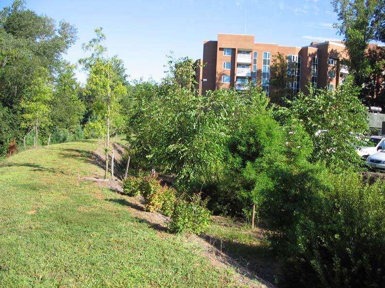
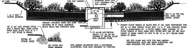

4 BIORETENTION


5 OTHER LID BMPs
6 The Northern Shenandoah Valley Regional Urban Manual for Low Impact Site Design (A Supplement to the Virginia Stormwater Management Handbook) The NSVRC s Goals Identify Identify the Stakeholders and their needs Create Create a Regional Manual that would meet the needs of the Stakeholders Allow Allow for a range of implementation mechanisms
7 PROJECT AREA NORTHERN SHENANDOAH VALLEY
8 PROJECT BACKGROUND Northern Shenandoah Valley Regional Commission Funded by National Fish and Wildlife Foundation 2003 Chesapeake Bay Small Watershed Grants Program Promote Application of LID in the Region Identify Physical and Policy Limitations to LID Application
9 THE PROJECT TEAM Mr. Brian Henshaw - Northern Shenandoah Valley Regional Commission C.J. Mitchem Terry Harrington - MarshWitt Associates Dr. Shane Parson & Sara Hyland - Va Tech Center for Geospatial Information Technology Steering Committee
10 PROJECT OVERVIEW Three Main Project Tasks Ordinance Review LID Applicability and Restrictions Study Development of Regional LID Manual The Fourth Task Steering Committee Input and Oversight
11 ORDINANCE REVIEW Terry Harrington - MarshWitt Associates Evaluation Criteria: Maximum Lot Coverage Standards Cluster Development Allowed/Required Parking Lot Pavement Requirement Parking Lot Landscaping Requirement Parking Lot Landscaping Flexibility Curb and Gutter Requirement Private Streets Allowed Intended to be a temporary chapter in manual
12 ORDINANCE REVIEW Maximum Lot Coverage Standards Allows Cluster Development Requires Pavement of Parking Lots Requires Parking Lot Landscaping Flexibility in Landscape Placement Requires Curb and Gutter Allows Private Streets Clark County Y Y Y Y Y Y N Town of Berryville N Y Y Y Y Y N Town of Boyce Y N N Y Y Y N Warren County N Y Y Y Y Y Y Town of Front Royal Y Y Y N Y Y N Page County Y N N N Y N Y Town of Stanley N N N N Y Y N Town of Shenandoah N N Y N Y N N Town of Luray N N Y N Y N N Shenandoah County N Y Y Y Y Y N Town of New Market Y N Y Y Y Y N Town of Edinburg N N Y N Y Y N Town of Woodstock Y N Y Y Y N N Town of Strasburg Y N Y Y Y Y N Frederick County Y Y Y Y Y Y Y Town of Stephens City Y N Y Y Y Y N Town of Middleton Y N Y N Y Y N City of Winchester Y Y Y Y Y Y Y Key 1 Curb and gutter can be waived 9 As part of approved PUD 2 When average lot size is less than one acre 10 Building coverage only; some districts 3 When all lots served are 10 acres or larger 11 Allows use of stabilized pavers 4 Commercial and industrial uses 12 In business districts 5 Private streets allow for some subdivisions 13 Currently being repealed 6 Building coverage only, except industrial zones 14 Varies by district 7 Shopping center frontage only 15 All-weather surface required 8 Commission can waive to allow more suitable surface 16 In industrial districts
13 ORDINANCE REVIEW As of 2005: Max. Lot Coverages Found in more than half (61%) 88% Require Paved Parking Lots 50% Allowed Cluster Development 60% Require Landscaping in Parking Lots 80% Require Curb and Gutter 20% Allow Private Streets (Limits Apply) Results Were Updated Following Steering Committee Review Added Phone Numbers for Local Staff (no names) to manual
14 LID APPLICABILITY AND RESTRICTIONS STUDY Shane Parson & Sara Hyland - Va Tech Center for Geospatial Information Technology Used GIS Tools for Analyses Physical Factors Considered Presence of Karst Topography Zoning Slope Soils Depth to Rock
15 LID APPLICABILITY AND RESTRICTIONS STUDY LID Practices Considered: Infiltration Based with NO Specific Slope Requirement Bio-retention Bio-filters Infiltration Trenches Seepage Pits Pervious Pavement Non-Infiltration Based Reduced road widths Curb and Gutter Elimination Curb Cuts Rain Barrels, Cisterns, etc. Downspout disconnections Surface Roughness Technology Green Roofs Infiltration Based with Specific Slope Requirement Vegetative Swales Buffer Strips
16 LID APPLICABILITY AND RESTRICTIONS STUDY LID on KARST ISSUES: Urban development in areas over karst geology can impact groundwater quality and soil/geology matrix stability (sinkholes). We must avoid certain LID practices that promote infiltration when these conditions are present. If karst is present, unfiltered surface runoff can enter groundwater storage, thus increasing the potential for groundwater contamination.
17 LID APPLICABILITY AND RESTRICTIONS STUDY RESTRICTIONS STUDY Suitability Weighting: LID PRACTICE CATEGORIES Zoning SUITABILITY FACTORS Soil Slope Karst Infiltration Based w/specific Slope Required Infiltration Based w/no Specific Slope Required 1 1 1* 1 Non-Infiltration Based Notes: A value of 1 symbolizes primary importance A value of 2 symbolizes secondary importance * Slopes less than 15% are suitable for these practices.
18 LID APPLICABILITY AND RESTRICTIONS STUDY Zoning Capability - Based on community zoning ordinances & VA Gap Analysis Land Use data Suitability rankings: 1. agriculture commercial residential industrial federal utility natural resource conservation non-vegetation vegetation future development town...0 Zoning Flexibility - Based on Ordinance Review Results The following criteria enables higher suitability: 1. Maximum Lot Coverage standard Yes 2. Curb and Gutter Required No 3. Landscape Placement Flexibility Yes 4. Pavement of Parking Lots Required No 5. Parking Lot Landscaping Required Yes 6. Cluster Development Yes 7. Private Streets Allowed Yes
19 Soil Infiltration LID APPLICABILITY AND RESTRICTIONS STUDY Based on hydrologic soil groups included in the SSURGO data. Hydrologic soil group A is most suitable and group D is least suitable. Based the Steering Committee feedback, the following factors were added to the analysis: Depth to bedrock Depth to water table 200 ft Limiting depth applied both
20 LID APPLICABILITY and RESTRICTIONS STUDY Slope Slope layer was derived from 10 meter DEM Suitability increases as slope decreases

21 LID APPLICABILITY and RESTRICTIONS STUDY KARST Karst layer derived from 1:250,000 scale map produced by DMME Scanned hard-copy map Geo-referenced map image Digitized karst geology boundaries Coded karst with 0 and noncarbonate areas with a value of 1

22 SUITABILITY MAPPING
23 SUITABILITY MAPPING
24 LID MANUAL DEVELOPMENT TECHNICAL RESOURCES UTILIZED: Prince Georges County, MD LID Design Manual, Hydrologic Analysis Virginia Low Impact Development Workgroup Draft Technical Bulletin Huntersville, NC Water Quality Ordinance Design Manual Virginia Stormwater Management Handbook (VADCR-DSWC, DSWC, 1999) Various Internet resources
25 REGIONAL LID MANUAL CONTENTS Chapter 1 - Manual Purpose and Use 1-1 Stream Channel Erosion 1-2 Stormwater Runoff Quality Chapter 2 - Local Ordinance Review 2-1 Introduction and Review Method 2-2 Results of Ordinance Review 2-3 Municipal Contacts Chapter 3 - Regional LID Suitability 3-1 Introduction 3-2 Suitability Assessment 3-3 Map Use Chapter 4 - LID Site Planning and Design 4-1 Introduction 4-2 The LID Site Planning Process 4-3 Determining Suitability 4-4 Conserving Resources 4-5 Minimizing Changes in Curve Number (CN) 4-6 Maintaining Site Time of Concentration (Tc) 4-7 Providing Retention 4-8 Providing Detention as Required 4-9 Facilitating Pollution Prevention 4-10 Analyzing Site Hydrology and Developing the Final LID Design
26 REGIONAL LID MANUAL CONTENTS Chapter 5 - Hydrologic Analysis Methodology for LID 5-1 Introduction 5-2 Summary of Hydrologic Analysis Methods 5-3 Hydrologic Comparison Between Conventional and LID Approaches 5-4 LID Hydrologic Analysis Methodology (Prince George s County Chapter 6 - LID BMP Minimum Standards 6-1 Bioretention Basins 6-2 Bioretention Filters 6-3 Infiltration Trenches 6-4 Vegetative Swales 6-5 Vegetated Filter Strips 6-6 Level Spreaders 6-7 Roof System BMPs 6-8 Roof Water Retention (Rain Barrels and Cisterns) 6-9 Roof Downspout Infiltration Systems 6-10 Roof Downspout Disconnections 6-11 Green Roofs6-12 Other Roadway and Parking Lot BMPs 6-13 Porous Pavement 6-14 Reduced Road Widths 6-15 Curb and Gutter Elimination 6-16 Curb Cuts 6-17 Surface Roughening 6-18 Manufactured BMP Systems Chapter 7 - Incentives to Utilize LID for Stormwater Management 7-1 Environmental Incentives 7-2 Financial Incentives 7-3 Other Incentives
27 FUTURE CONSIDERATIONS New Stormwater Management regulations water quality Maintenance Chapter Model Maintenance Agreement Phasing Erosion & sediment control Retrofitting Long driveways with steep slopes Stream buffers as a BMP & other BMP s
28 Questions?