30 DAY PUBLIC NOTICE MAINTENANCE DREDGING OF THE PLYMOUTH HARBOR FEDERAL NAVIGATION PROJECT PLYMOUTH, MASSACHUSETTS
|
|
|
- Julia Greer
- 5 years ago
- Views:
Transcription

1 696 Virginia Road Concord, MA Public Notice In Reply Refer to: Mr. Michael Walsh Programs & Project Management Division Date: June 14, 2018 Comment Period Closes: July 14, DAY PUBLIC NOTICE MAINTENANCE DREDGING OF THE PLYMOUTH HARBOR FEDERAL NAVIGATION PROJECT PLYMOUTH, MASSACHUSETTS Interested parties are hereby notified that the U.S. Army Corps of Engineers (Corps), New England District (NAE), plans to perform maintenance dredging of the Federal navigation project at Plymouth Harbor, MA, involving work in the navigable waters of this District, under the provisions of Section 103 of the Marine Protection, Research and Sanctuaries Act of 1972 (P.L ) and Section 404 of the Clean Water Act of 1977 (P.L ) and to authorize such work in accordance with Title 33, Parts of the Code of Federal Regulations. Attachment No. 1 lists pertinent laws, regulations, and directives. Project Description: The proposed work involves maintenance dredging of the 18-foot-deep Mean Lower Low Water (MLLW) main channel, the 15-foot-deep MLLW channel extension and turning basin, and the 60 acre by 8-foot-deep MLLW anchorage, comprising the Plymouth Harbor Federal navigation project (FNP). The 18-foot MLLW main channel will be dredged to its maintained depth of 15-feet MLLW, while all other project features will be dredged to authorized dimensions. The existing project was originally authorized in the Act of 26 May 1824, and modified by the Act of 1868, and the Rivers & Harbors Acts of 1870, 1875, 1884, 1899, 1913, 1922, 1938, 1962, 1965, and Character and Purpose of Work: Natural shoaling processes have reduced available depths to as little as 7.0 feet in the 18' main channel, 7.0 feet in the 15' channel, and 4.0 feet in the 8' anchorage, making navigation hazardous at lower stages of the tide. Maintenance dredging of approximately 385,000 cubic yards (cy) of sand and silt from approximately 75 acres of the authorized project area will restore the project to authorized dimensions (See Attachment 2). The 18-foot MLLW entrance channel contains approximately 41,000 cy of fine sand. This material is proposed for placement at the Green Harbor Beach nearshore site dependent upon site capacity. The remaining material (approximately 344,000 cy) is primarily silt and clay, and proposed for placement at the Cape Cod Bay (CCBDS) and Massachusetts Bay Disposal Sites (MBDS). Construction is expected to take between 5-6 months within the allowable dredge window of October 1 to January 31 of any given year. The work is currently anticipated to be performed in 2018/2019 or 2019/2020. If dredging is not complete in one season, construction will occur the following season within the allowable dredge window. The application of this window will limit Plymouth Harbor FNP Page 1 of 10
2 adverse impacts to federally-listed endangered and threatened species as well as avoid the eelgrass growing season, anadromous fish migrations, and the spawning of winter flounder and shellfish. Placement of sand at the Green Harbor Beach nearshore site will not begin until November 1 of any year for the protection of juvenile lobsters. Placements will occur at the CCBDS (which is closer in proximity to Plymouth Harbor) from October 1 to December 31 and at the MBDS from January 1 to January 31. Placements at CCBDS will cease after December 31 for the protection of endangered North Atlantic right whales. Utilizing the MBDS for the month of January will maximize the amount of dredging to be accomplished within the work window. Disposal Area Options: The dredged material has undergone physical, chemical, and biological testing and has satisfied the criteria for ocean disposal of dredged material as specified in Part 227 of the Marine Protection, Research and Sanctuaries Act regulations and Section 404 of the Clean Water Act. Approximately 41,000 cy of material in the 18-foot MLLW channel, to be dredged to 15-feet MLLW, is primarily sand (88.6% fine sand). This material is proposed for placement at the previously used nearshore site off Green Harbor Beach (See Attachment 3). The amount placed at the nearshore site will depend upon site capacity at the time of placement. Approximately 344,000 cy of dredged material from the 15-foot MLLW channel, turning basin and anchorage is predominately silt. This material is proposed to be mechanically dredged and disposed at the Cape Cod Bay Disposal Site and the Massachusetts Bay Disposal Site. The CCBDS was selected by the Corps as an open water disposal site in 1990, and the MBDS was officially designated by the U.S. Environmental Protection Agency in (See Attachments 4 & 5). The Corps has coordinated with the U.S. EPA and Commonwealth of Massachusetts, and determined that the material is suitable for disposal at each of these disposal sites. Disposal Sites: The Green Harbor nearshore site (Attachment 3) is located approximately 9.5 nautical miles (NM) from Plymouth Harbor off of Green Harbor Beach in water depths ranging between 15 and 9 feet MLLW. The approximately 11-acre site has previously been used for placement of material dredged from the Green Harbor FNP entrance channel and the Cohasset Harbor FNP entrance channel. This site has been used on a regular basis (often annually) for the past 35 years. The Cape Cod Bay Disposal Site (Attachment 4) is approximately 22 NM east of Plymouth Harbor in Cape Cod Bay, and is centered at coordinates ' N, ' W (NAD 83). CCBDS receives sediments dredged primarily from Wellfleet, Barnstable, Plymouth, and Duxbury Harbors. Approximately 817,780 yd 3 of material have been disposed at the site to date. The Massachusetts Bay Disposal Site (Attachment 5), a 2.0 NM diameter circular area centered at ' N, ' W (NAD 83), is located 30 NM north of Plymouth Harbor. The MBDS is frequently used for disposal of bottom sediments from various harbors in the Boston area. Approximately 300,000 cubic yards of suitable sediments (suitability determined through case-by-case analyses) are deposited at this site annually. Both disposal sites are monitored through the Corps Disposal Area Monitoring System (DAMOS) program. The DAMOS studies show that both sites are in low energy environments such that sediments deposited at these locations will remain within the boundaries of each site. The DAMOS monitoring has also shown that distinct dredged material mounds have been formed at the sites. Levels of metals and organics in the sediments within the MBDS are generally above background levels, indicative of the industrial nature of the areas dredged that utilize the sites. Sediment deposited at both disposal sites has not been found to affect areas outside each sites boundaries. Plymouth Harbor FNP Page 2 of 10
3 Additional Information: Additional information may be obtained from Mr. Michael Walsh, Programs/Civil Project Management Branch, Programs/Project Management Division, at the return address shown, telephone number (978) Coordination: The proposed work is being coordinated with the following Federal, State, and local agencies: Federal U.S. Environmental Protection Agency U.S. Fish and Wildlife Service National Marine Fisheries Service Commonwealth of Massachusetts Massachusetts Office of Coastal Zone Management Massachusetts Department of Environmental Protection Massachusetts Division of Marine Fisheries Massachusetts Historical Commission Massachusetts Board of Underwater Archaeological Resources Federally Recognized Tribes Mashpee Wampanoag Tribe Wampanoag Tribe of Gay Head (Aquinnah) Local Town of Plymouth Harbormaster Town of Plymouth Division of Marine and Environmental Affairs Environmental Impacts: A draft Environmental Assessment for this work has been prepared and is available for review upon request. I have made a preliminary determination that an Environmental Impact Statement is not required under the provisions of the National Environmental Policy Act of This determination will be reviewed in light of facts submitted in response to this notice. Federal Consistency with Massachusetts Coastal Zone Management Program: I find that maintenance dredging of the authorized navigation project is consistent to the maximum extent practicable with the Commonwealth of Massachusetts' management program established as a result of the Coastal Zone Management Act of The dredging and disposal operation will be conducted to the maximum extent practicable in a manner that is consistent with the approved management program. Other Information: a. Local Sponsor: The Town of Plymouth, Massachusetts, is the local sponsor for the proposed work. b. Previous Dredging: A partial maintenance dredging of the entrance channel was performed in The last full maintenance dredging was performed in 1964 and 1967, with previous dredging projects occurring in 1954, 1953, 1952, 1939, 1934, and Plymouth Harbor FNP Page 3 of 10
4 c. Alternate Disposal Methods: Alternate disposal options that have been considered include open-ocean disposal, beach and nearshore disposal, and upland disposal. The Corps favors nearshore disposal of the sandy material because of the benefit in retaining the sand in the littoral system and possibly providing indirect nourishment to adjacent beaches over time. The silty material is not appropriate for nearshore placement, therefore open-ocean disposal at the Cape Cod Bay and Massachusetts Bay Disposal Sites is pursued. A suitable upland disposal site was not identified. d. Non-Federal Dredging: To date there are no non-federal dredging projects proposed in connection with the proposed Federal maintenance dredging. Facility owners within the harbor who may be interested in performing non-federal dredging concurrently with this project should be aware that work will require a permit from the Army Corps of Engineers under Section 10 of the Rivers and Harbors Act and, depending on the location of the non-federal dredged material disposal, may also require a Corps permit under Section 404 of the Clean Water Act. In order to be disposed of in ocean waters, private dredged material must be determined to be suitable for such disposal. e. Endangered Species: It is our preliminary determination that this proposed project may affect, but is not likely to adversely affect, any species listed as threatened or endangered under the Endangered Species Act of 1973 (87 Stat. 844). The Corps will consult with the National Marine Fisheries Service and the U.S. Fish and Wildlife Service to verify that the proposed activity will not significantly affect any species or critical habitat designated as endangered or threatened. f. Floodplain Management: In accordance with Executive Order 11988, the Corps of Engineers has determined that the proposed work will not contribute to negative impacts or damages caused by floods. g. Cultural Resources: The proposed work consists only of maintenance, involving previously dredged areas and previously used disposal sites, and will not affect any cultural or archaeological features or resources in the area of dredging or disposal. USACE will coordinate our findings with the State Historic Preservation Officer, Board of Underwater Archaeological Resources, and the two Tribal Nations in accordance with Section 106 of the National Historic Preservation Act and implementing regulations (36 CFR 800). h. Essential Fish Habitat Assessment: It has been determined that dredging and placement activities may have a temporary adverse effect on Essential Fish Habitat (EFH). The dredging and disposal sites are contained within areas designated EFH as defined by the Magnuson- Stevens Fishery Conservation and Management Act and amended by the Sustainable Fisheries Act of 1996 for federally managed fish species. The Corps has assessed the effects the project is likely to have on EFH and has determined that they will be short-term and localized and that there will be no significant impacts on the designated fisheries resources. The Corps will consult with the National Marine Fisheries Service to ensure that all impacts will be minimized. i. Additional Requirements: A 401 Water Quality Certificate will be requested from the Commonwealth of Massachusetts. Plymouth Harbor FNP Page 4 of 10
5 The decision whether to perform the proposed work will be based on an evaluation of the probable impact of the proposed activity on the public interest. That decision will reflect the national concern for both protection and utilization of important resources. The benefits, which reasonably may be expected to accrue from the proposal, will be balanced against its reasonably foreseeable detriments. All factors that may be relevant to the proposal will be considered; among these are conservation, economics, aesthetics, general environmental concerns, historic values, fish and wildlife values, flood damage prevention, land use classification, and the welfare of the people. Any person who has an interest, which may be affected by the dredging and disposal of this dredged material may request a public hearing. The request must be submitted in writing to the District Engineer within the comment period of this notice and must clearly set forth the interest, which may be affected and the manner in which the interest may be affected by this activity. Please bring this notice to the attention of anyone you know to be interested in this project. Comments are invited from all interested parties and should be directed to the U.S. Army Corps of Engineers, New England District, 696 Virginia Road, Concord, MA , ATTN: Michael Walsh, or to address nae-pn-nav@usace.army.mil within 30 days of this notice. Attachments William M. Conde Colonel, Corps of Engineers District Engineer Plymouth Harbor FNP Page 5 of 10
6 Attachment 1 PERTINENT LAWS, REGULATIONS, AND DIRECTIVES Marine Protection, Research, and Sanctuaries Act of 1972 (33 U.S.C et seq.) Clean Water Act, as amended (33 U.S.C et. seq.) Code of Federal Regulations, Title 33, Parts 335 through 338 National Environmental Policy Act of 1969 (42 U.S.C ) Fish and Wildlife Coordination Act (16 U.S.C c) Fish and Wildlife Act of 1956 (16 U.S.C. 472a, et. seq.) Migratory Marine Game-Fish Act (16 U.S.C. 760c-760g) Sections 307(c)(1) and (2), Coastal Zone Management Act of 1972 [16 U.S.C. 1456(c)(1) and (2)] National Historic Preservation Act of 1966 (16 U.S.C. 470) Endangered Species Act of 1973 as amended (16 U.S.C. 668aa-668cc) Clean Air Act, as amended (42 U.S.C et. seq.) Estuary Protection Act (16 U.S.C et. seq.) Federal Water Project Recreation Act, as amended (16 U.S.C et. seq.) Land and Water Conservation Fund Act of 1965, as amended (16 U.S.C et. seq.) Magnuson-Stevens Fishery Conservation and Management Act and amended by the Sustainable Fisheries Act of 1996 Executive Order 11988, Floodplain Management, 24 May 1977 Executive Order 11990, Protection of Wetlands, 24 May 1977 Executive Order 12898, Federal Actions to Address Environmental Justice in Minority Populations and Low Income Populations, 11 February 1994 Plymouth Harbor FNP Page 6 of 10

7 Attachment 2 Plymouth Harbor FNP Dredge Areas Plymouth Harbor FNP Page 7 of 10

8 Attachment 3 Green Harbor Beach Nearshore Placement Site Plymouth Harbor FNP Page 8 of 10


9 Attachment 4 Cape Cod Bay Disposal Site Plymouth Harbor FNP Page 9 of 10
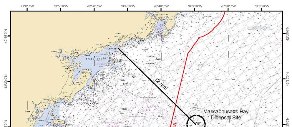
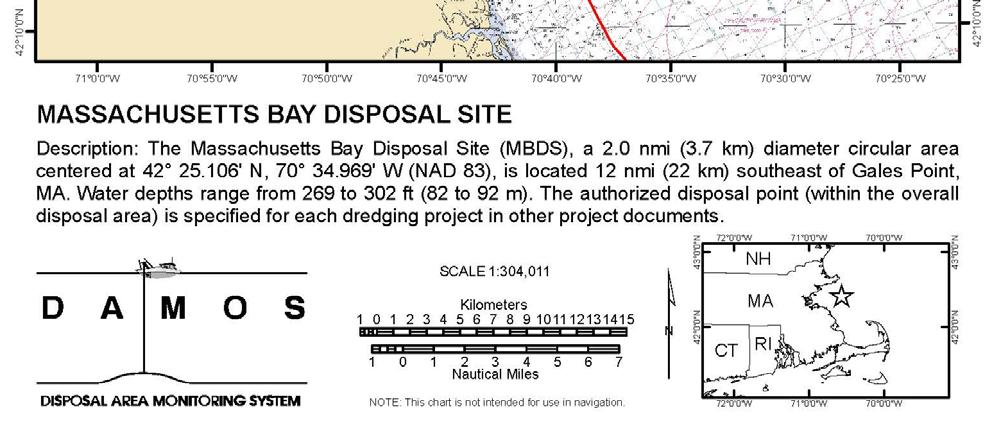
10 Attachment 5 Massachusetts Bay Disposal Site Plymouth Harbor FNP Page 10 of 10