J O I N T P U B L I C N O T I C E
|
|
|
- Timothy Davidson
- 5 years ago
- Views:
Transcription
1 J O I N T P U B L I C N O T I C E CHARLESTON DISTRICT, CORPS OF ENGINEERS 69A Hagood Avenue Charleston, South Carolina and THE S.C. DEPARTMENT OF HEALTH AND ENVIRONMENTAL CONTROL Office of Environmental Quality Control Water Quality Certification and Wetlands Programs Section 2600 Bull Street Columbia, South Carolina REGULATORY DIVISION Refer to: P/N # T (Revision) 12 November 2014 **This public notice is being reissued because the proposed project will occur in Section 10 waters. All previous comments provided in response to the original public notice issued September 5, 2014, will be be considered. Revised and/or additional comments may be provided. No additional changes to the originally proposed project have occurred.** Pursuant to Section 10 of the Rivers and Harbors Act of 1899 (33 U.S.C. 403), Sections 401 and 404 of the Clean Water Act (33 U.S.C. 1344), the South Carolina Coastal Zone Management Act ( et.seq.), an application has been submitted to the Department of the Army and the S.C. Department of Health and Environmental Control by ANTHONY ITTLESON C/O FOLK LAND MANAGEMENT, INC. TRAVIS FOLK 3515 WHITE HALL ROAD GREEN POND, SOUTH CAROLINA for a permit to place fill in wetlands and impound water in wetlands associated with the ASHEPOO RIVER In a inland rice field adjacent to Bennetts Point Road on Poco Sabo Plantation which is located 1375 Poco Sabo Lane in Green Pond, Colleton County, South Carolina ( Latitude/ Longitude) N O T I C E is hereby given that written statements regarding the proposed work will be received by the Corps until 15 Days from the Date of this Notice, and SCDHEC will receive written statements regarding the proposed work until 30 Days from the Date of this Notice from those interested in the activity and whose interests may be affected by the proposed work.
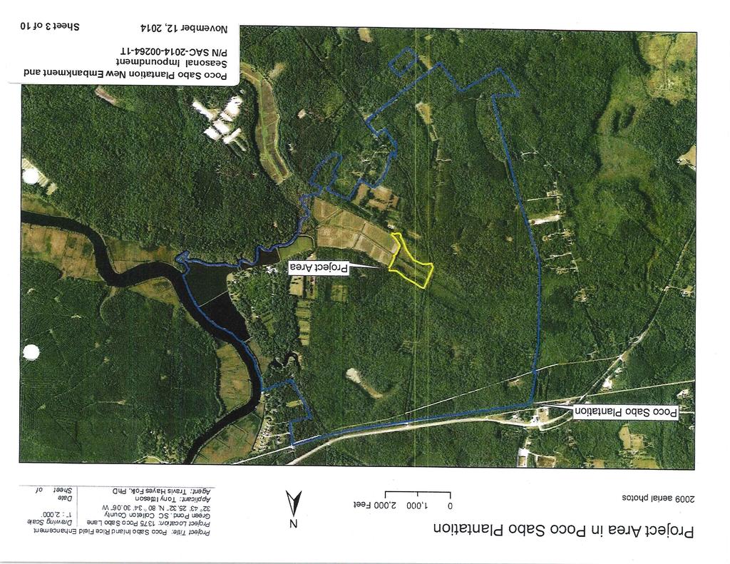
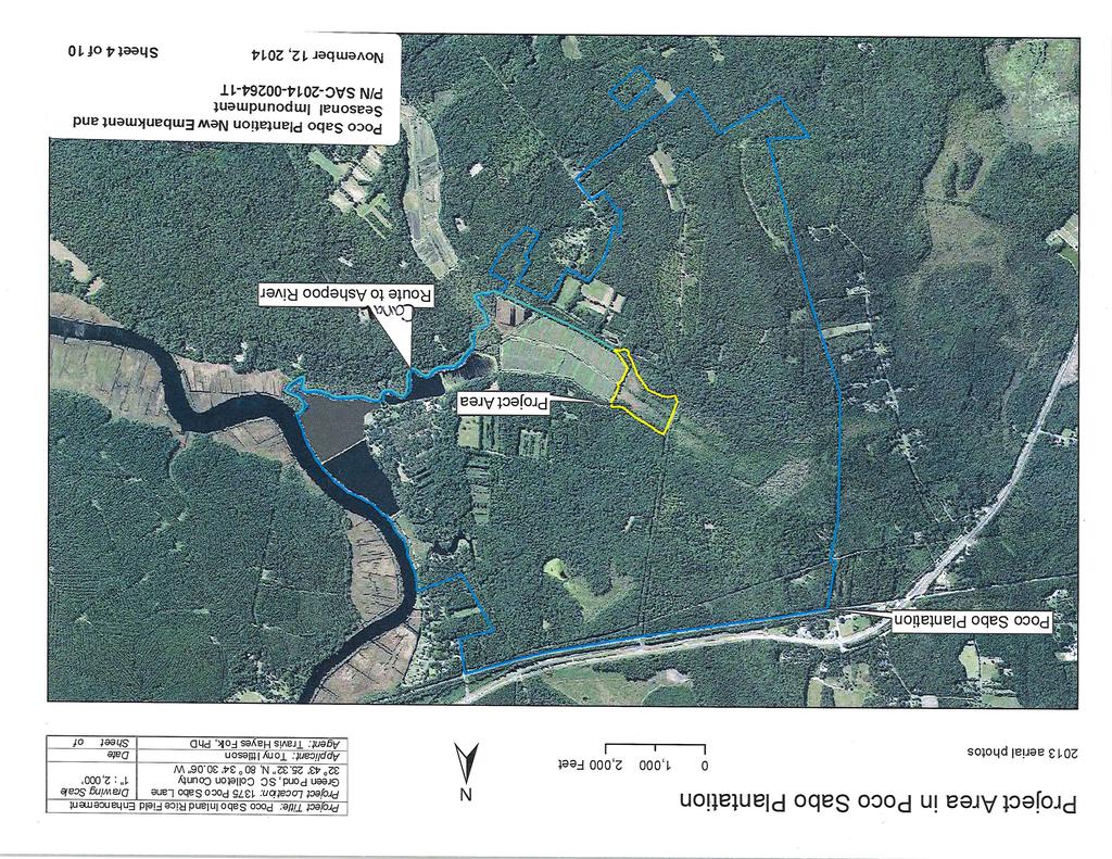
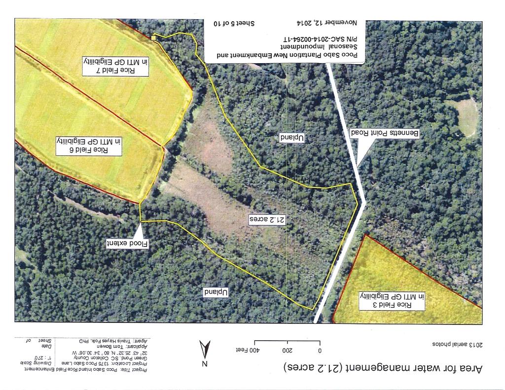
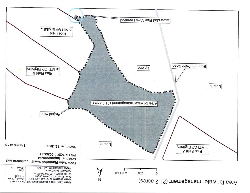
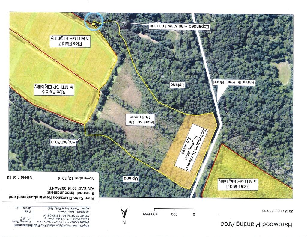
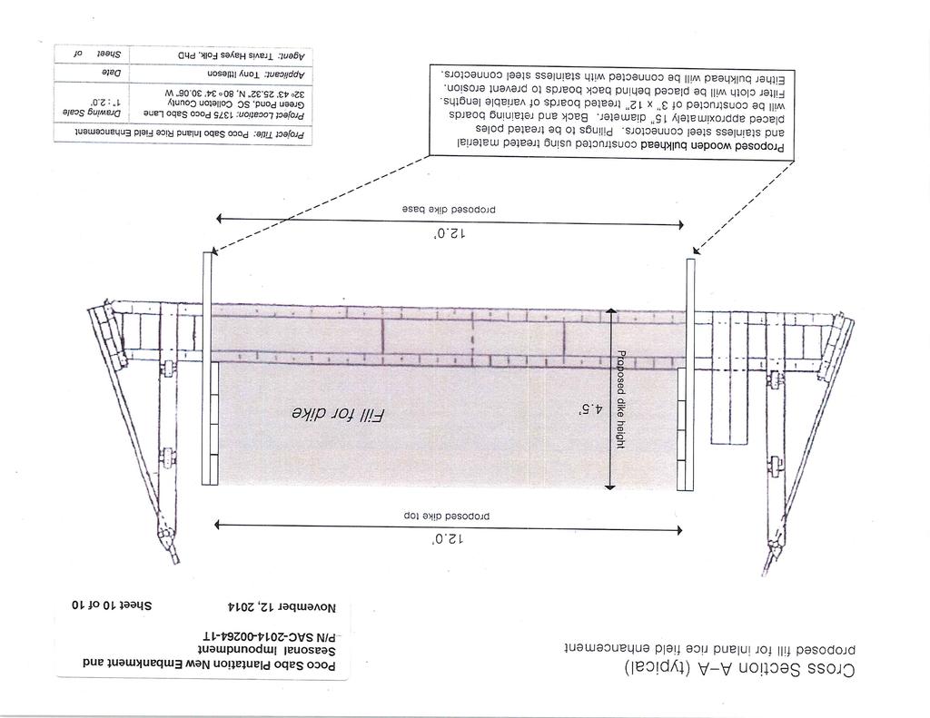
2 REGULATORY DIVISION Refer to: P/N # T 12 November 2014 The proposed work consists of the construction of a 12 wide X 40 long embankment with a water control structure (trunk) in 480 square feet of a tidal canal to seasonally impound 21.2 acres of freshwater wetlands that receive tidal influences within a former inland rice field. The fill material of the embankment will be contained by wooden bulkheads. The bottom width and top width of the embankment is 12 feet. Purpose The purpose of the proposed work is to seasonally impound water to enable better habitat management of 21.2 acres of former inland rice field. The applicant states that habitat management is not currently possible and invasive plant species are present in the area. Construction of the embankment and installation of the trunk would allow for the elimination of invasive plant species, restoration of bottomland hardwood species, and management of native wetland early successional flora. Avoidance and Minimization The applicant stated that impacts to Waters of the U.S. have been minimized by constructing a bulkhead on both sides of the embankment to allow for the 12 wide top and bottom widths. Without the bulkhead, the bottom width of the embankment would be approximately wide resulting in 800 square feet of fill impacts. The applicant is also proposing to vegetate the new embankment with fast growing plant species immediately after construction to minimize erosion. To further avoid impacts, the applicant chose to locate the proposed embankment at a narrow section of wetlands. Compensatory Mitigation The applicant stated that they believe compensatory mitigation is not necessary for the following reasons: 1) Installation of the trunk will enable the applicant to manage 21.2 acres of wetlands for wildlife habitat. Wood storks and bald eagles are commonly seen in the managed impoundment immediately to the east and the applicant believes that the proposed project will provide additional habitat for these endangered species. 2) The ability to manage this area would result in the elimination of several invasive, exotic plant species from the area (e.g., alligatorweed (Alternanthera philoxeroides) and Chinese tallow (Triadica sebifera). The ability to dewater the impoundment will enable the applicant to employ a wider variety of vegetation control techniques (prescribed fire or prolonged submersion) than currently exists. 3) The applicant will also reforest a portion of the project area with bottomland hardwood species (i.e., bald cypress (Taxodium distichum) and water tupelo (Nyssa aquatic). The area of planting is shown on the project drawings. Management of Impoundment The applicant stated that 15.4 acres of the 21.2 acre impoundment will be managed as a seasonal moist soil impoundment. This management strategy focuses on native herbaceous wetland species. Prescribed fire, occasional mechanical disturbance, and flushing of canals will be done to promote these species. At this site, the invasive plant species will first be controlled. Once controlled, management will be similar across years. In the spring, once the area is fully dewatered, the site will be burned. This removes biomass from the previous growing season and allows more sunlight to reach the bed of the impoundment. Occasional floodings will occur during the growing season. Plant species targeted by moist soil management (e.g. smartweed, panic grass, etc.) require soil moisture.
3 REGULATORY DIVISION Refer to: P/N # T 12 November 2014 This water will not sit permanently on the bed and flooding will only be sufficient enough to keep the rice field bed from being dry. After the growing season, prescribed fire or bush hog will be used to create openings in the herbaceous vegetation. These openings are critical to ensure waterbirds use of the rice field. The field will be flooded following this treatment and kept to a depth of 9 to 1.0. The 21.2-acre impoundment will be flooded during the months of November through February. This flooding regime will protect hardwood species from root inundation and tree mortality. The 5.8-acre area where bottomland hardwood species will be planted will not be managed as moist soil. Several invasive plant species exist in the project area: alligator weed and Chinese tallow. The applicant stated that they will treat both with EPA wetland rated herbicides. First, the project area would be dewatered such that a tractor could enter the wetland. Once sufficiently dry, a tractor would apply via a sprayer the herbicide Habitat (5% by volume concentration, with 1% non-ionic surfactant) to areas infested with alligator weed. This is a standard methodology for the treatment of this species. Chinese tallow would be treated with a hack-and-squirt application for larger trees and foliar application for smaller individuals. The herbicide Clearcast will be used for both applications as 50% concentration for hack-and-squirt to the cambium layer and 5% concentration for the foliar. Hand crews will apply Clearcast for both types of application. Prescribed fire will also be used to remove dead biomass once the initial herbicide application is completed. This will allow new growth to be seen easily for follow up herbicide treatments. Site Conditions of Project Area The site is predomindantly vegetated with herbaceous wetlands species and intermittent tree and shrub species. Dominant herbaceuous species are alligator weed and common cattail. Shrub species are intermittent and are primarily buttonbush. Tree species are restricted to the remnant portions of dike that cross the project area are Chinese tallow, red maple, and black willow. Please note that the surrounding impoundment fields labeled Rice Fields 3, 6, and 7, on the project drawings are existing managed impoundments that are also located on Poco Sabo Plantation. (Note: Fields 3, 6, and 7 were determined to be eligible for use of the Managed Tidal Impoundment General Permit, SAC The proposed project area was not determined eligible for use of the General Permit because it is not an existing and functional managed impoundment). The project area is bounded to the north and south by uplands, to the east by Field 6 and 7, and to the west by Bennetts Point Road and Field 3. There is an existing narrow canal between Bennetts Point Road and Field 3. Field 3 dewaters into this canal and then passes through a pipe that goes under the road and into the project area. The District Engineer has concluded that the discharges associated with this project, both direct and indirect, should be reviewed by the South Carolina Department of Health and Environmental Control in accordance with provisions of Section 401 of the Clean Water Act. As such, this notice constitutes a request, on behalf of the applicant, for certification that this project will comply with applicable effluent limitations and water quality standards. The work shown on this application must also be certified as consistent with applicable provisions of the South Carolina Coastal Zone Management Act (15 CFR 930). The District Engineer will not process this application to a conclusion until such certifications are received. The applicant is hereby advised that supplemental information may be required by the State to facilitate the review. Persons wishing to comment or object to State certification must submit all comments in writing to the S.C. Department of Health and Environmental Control at the above address within thirty (30) days of the date of this notice.
4 REGULATORY DIVISION Refer to: P/N # T 12 November 2014 This notice initiates the Essential Fish Habitat (EFH) consultation requirements of the Magnuson- Stevens Fishery Conservation and Management Act. Implementation of the proposed project would impact 21.2 acres wetlands and tidal waters utilized by various life stages of species comprising the red drum, shrimp, and snapper-grouper management complexes. Our initial determination is that the proposed action would not have a substantial individual or cumulative adverse impact on EFH or fisheries managed by the South Atlantic Fishery Management Council and the National Marine Fisheries Service (NMFS). Our final determination relative to project impacts and the need for mitigation measures is subject to review by and coordination with the NMFS. The District Engineer has consulted the most recently available information and has determined that the project will have no effect on any Federally endangered, threatened, or proposed species and will not result in the destruction or adverse modification of designated or proposed critical habitat. This public notice serves as a request to the U.S. Fish and Wildlife Service and the National Marine Fisheries Service for any additional information they may have on whether any listed or proposed endangered or threatened species or designated or proposed critical habitat may be present in the area which would be affected by the activity, pursuant to Section 7(c) of the Endangered Species Act of 1973 (as amended). Pursuant to Section 106 of the National Historic Preservation Act (NHPA), this public notice also constitutes a request to Indian Tribes to notify the District Engineer of any historic properties of religious and cultural significance to them that may be affected by the proposed undertaking. In accordance with the NHPA, the District Engineer has also consulted the latest published version of the National Register of Historic Places for the presence or absence of registered properties, or properties listed as being eligible for inclusion therein, and this worksite is not included as a registered property or property listed as being eligible for inclusion in the Register. To insure that other cultural resources that the District Engineer is not aware of are not overlooked, this public notice also serves as a request to the State Historic Preservation Office to provide any information it may have with regard to historic and cultural resources. Any person may request, in writing, within the comment period specified in this notice, that a public hearing be held to consider this application. Requests for a public hearing shall state, with particularity, the reasons for holding a public hearing. The decision whether to issue a permit will be based on an evaluation of the probable impact including cumulative impacts of the activity on the public interest and will include application of the guidelines promulgated by the Administrator, Environmental Protection Agency (EPA), under authority of Section 404(b) of the Clean Water Act and, as appropriate, the criteria established under authority of Section 102 of the Marine Protection, Research and Sanctuaries Act of 1972, as amended. That decision will reflect the national concern for both protection and utilization of important resources. The benefit which reasonably may be expected to accrue from the project must be balanced against its reasonably foreseeable detriments. All factors which may be relevant to the project will be considered including the cumulative effects thereof; among those are conservation, economics, aesthetics, general environmental concerns, wetlands, historic properties, fish and wildlife values, flood hazards, flood plain values, land use, navigation, shoreline erosion and accretion, recreation, water supply and conservation, water quality, energy needs, safety, food and fiber production and, in general, the needs and welfare of the people. A permit will be granted unless the District Engineer determines that it would be contrary to the public interest. In cases of conflicting property rights, the Corps of Engineers cannot undertake to adjudicate rival claims.
5 REGULATORY DIVISION Refer to: P/N # T 12 November 2014 The Corps of Engineers is soliciting comments from the public; Federal, state, and local agencies and officials; Indian Tribes; and other interested parties in order to consider and evaluate the impacts of this activity. Any comments received will be considered by the Corps of Engineers to determine whether to issue, modify, condition or deny a permit for this project. To make this decision, comments are used to assess impacts on endangered species, historic properties, water quality, general environmental effects, and the other public interest factors listed above. Comments are used in the preparation of an Environmental Assessment and/or an Environmental Impact Statement pursuant to the National Environmental Policy Act. Comments are also used to determine the need for a public hearing and to determine the overall public interest of the activity. If there are any questions concerning this public notice, please contact Tracy Dotolo Sanders at or toll free at
6
7
8
9
10
11
12
13
14
15