Sorrento to Miramar 4(f) De Minimis Determination
|
|
|
- Avis Manning
- 5 years ago
- Views:
Transcription
")

1 Sorrento to Miramar 4(f) De Minimis Determination
 2013 Annual Ridership: 1.")
2 LOSSAN Overview Bruce Smith PE SM2 Project Manager with SANDAG What is LOSSAN? A 351-mile coastal rail corridor Los Angeles San Diego San Luis Obispo Built in the 1880s Second busiest U.S. passenger corridor 60-mile San Diego segment maintained by North County Transit District (NCTD) 2013 Annual Ridership: 1.7M on COASTER 2.6M on Amtrak Freight service by BNSF 2

3 Project Background Adds two miles of second main track along Miramar Grade to allow trains to pass Straightens curves in track to increase passenger train speeds from 25 to 40 mph Will reduce travel times, enhance reliability and improve efficiency Will assist in meeting projected future ridership and freight service needs 3
 is preparing a NEPA Environmental Assessment evaluating the two selected")
4 Alternatives Analysis Alternative analysis in 2010 Based on a variety of constraints, two primary alternative alignments were selected for further study The Federal Railroad Administration (FRA) is preparing a NEPA Environmental Assessment evaluating the two selected alternatives 4

5 Project Alternatives Alternative 1 Mostly within the existing railroad right-of-way along the south side of Soledad Canyon Alternative 2 Traverses a new right-of-way corridor along the north side of Soledad Canyon and includes two new railroad bridges Alt 2 Alt 1 5
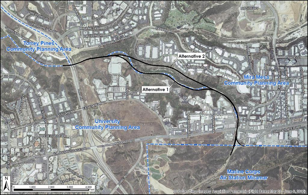
6 Project Alternatives Map 6
 of U.S. Department of Transportation (DOT) Act of 1966 Studied alternatives to feasibly minimize 4(f) impacts 7")
7 Regulatory Considerations Erich Lathers This federal project falls under the Interstate Commerce Commission Termination Act, which preempts state and local regulation As a federal transportation project, it is subject to Section 4(f) of U.S. Department of Transportation (DOT) Act of 1966 Studied alternatives to feasibly minimize 4(f) impacts 7
8 Section 4(f) Resources Section 4(f) properties or resources include: Publicly-owned parklands and recreational lands Publicly-owned wildlife and waterfowl refuges Historic sites of national, state, or local significance City-owned Multi-Habitat Planning Area (MHPA) lands are considered to qualify as Section 4(f) resources under the wildlife and waterfowl refuges category 8
9 Section 4(f) Resources What are MHPA lands? The MHPA delineates core biological resources areas and corridors targeted for conservation to create a planned habitat preserve Considered an urban preserve which is constrained by existing or approved development, and is comprised of linkages connecting several large areas of habitat Developed by the city in cooperation with wildlife agencies, property owners, developers, and environmental groups 9
 Resources: 0.49 acre Total 4(f) Resources: 56.")
10 Alternative 1 - Impacts to 4(f) resources Alternative 1 Impacts to 4(f) Resources: 0.49 acre Total 4(f) Resources: acres 10
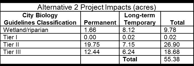
 Resources: 10.85 acres Total 4(f) Resources: 56.")
11 Alternative 2 - Impacts to 4(f) resources Alternative 2 Impacts to 4(f) Resources: acres Total 4(f) Resources: acres 11

 to prevent soil erosion at the drainage outlet Vegetation will need to be cleared in")
12 Section 4(f) Impacts Alternative acres of impacts are for drainage systems; Needed to convey storm water runoff underneath the railroad Involves construction of and planting of several gabion mattresses (rocks wrapped in a wire mesh) to prevent soil erosion at the drainage outlet Vegetation will need to be cleared in and around the gabion mattress sites which will be replanted 12


13 Section 4(f) Impacts Mitigation Photo of Gabions that have revegetated in Crest Canyon, Del Mar Gabions installed some years ago across the valley to control erosion 13

14 Section 4(f) Impacts Alternative acre of MHPA land would be excavated; On the eastern corner of parcel , 0.03 acre of MHPA land would be excavated to a steeper slope This landform alteration will remove native vegetation and the cut slope may be too steep to revegetate, therefore removing some biological value 14
15 De Minimis Impact Determination The use of a Section 4(f) resource may be determined de minimis if, after opportunity for public review and comment, FRA finds that a transportation project will not adversely affect the activities, features, and attributes qualifying the property for protection under Section 4(f) after mitigation, and the officials with jurisdiction over the park or ecological reserve concur with the finding. 15
16 De Minimis Impact Determination The impacts to 4(f) resources are not considered to adversely affect the activities, features, and attributes that qualify the resource for protection for the following reasons: 1. The 0.03 acre to be excavated constitutes a very minor portion of the MHPA land located at a cliff edge adjacent to the railroad right-of-way where there is low biological value 2. Gabion mattresses (0.46Ac) are an allowable use within the MHPA per the City regulations that implement the City MSCP Subarea Plan 3. The biological impacts would be mitigated in conformance with the City of San Diego MSCP Subarea Plan and implementing regulation 16
17 Next Steps De Minimis Concurrence from City of San Diego (mid-2015) FRA approval of EA (mid-2015) SANDAG releases EA for Public Review (mid-2015) Environmental Clearance from FRA (FONSI late-2015) Final Design ( ) Right-of-Way Acquisition (Pending funding) Construction (Pending funding) 17
18 Stay Involved Online Information: Sign Up to Receive Project s: Additional Specific Project Questions or Comments contact: Engineering: Bruce Smith P.E., Senior Engineer (619) ; Environmental Cheryle Hodge, Senior Environmental Planner (619) ; 18