Core Program Areas. Department of Environmental Quality 3/21/2017. Division of Waste Management. Division of Waste Management
|
|
|
- Blake Cox
- 5 years ago
- Views:
Transcription


1 Department of Environmental Quality Division of Waste Management Use of GIS to Improve Public Access & Knowledge of DWM Site Inventories Core Program Areas Division of Waste Management Superfund Section Hazardous Waste Section Solid Waste Section Underground Storage Tank Section Brownfields Program 1

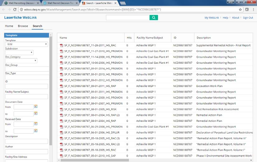
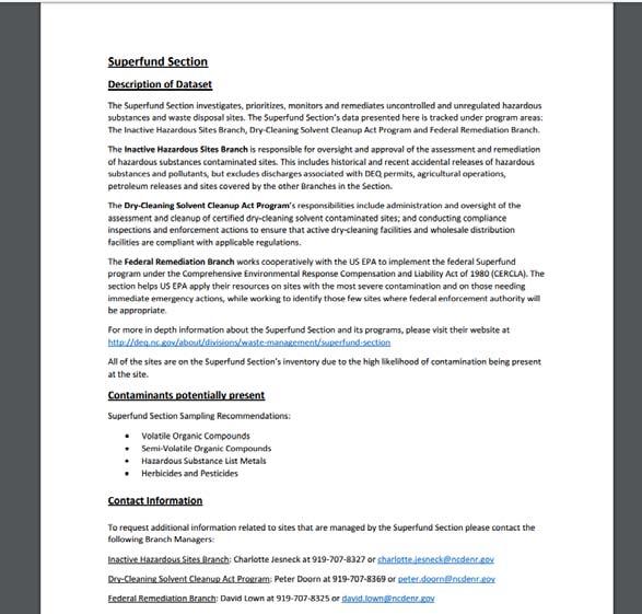
2 Superfund Section Investigates and remediates uncontrolled and unregulated hazardous substance and waste disposal sites. Special Remediation Branch Addresses contamination at dry cleaning sites, under the authority of the Dry-Cleaning Solvent Cleanup Act of Federal Remediation Branch Implements the federal Superfund program in North Carolina for US EPA. Works to apply federal resources on sites with the most severe contamination and on those needing immediate emergency actions. These sites are typically DOD, DOE or NPL sites. Inactive Hazardous Sites Branch Responsible for oversight of the assessment and remediation of sites contaminated with hazardous substances. This Branch handles sites that are not regulated by other programs within the Division. Hazardous Waste Section Ensures the safe management of hazardous industrial waste by implementing federal regulations adopted under the Resource Conservation and Recovery Act (RCRA) and state requirements. Types of Sites Include: Registered Generators of Large and Small Quantities Sites with known contamination Facilities Licensed to Transport, Treat and Store Hazardous Waste 2


 underground storage tanks (USTs).")

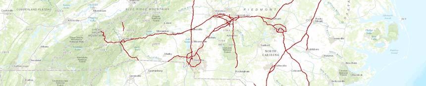
3 Solid Waste Section Regulates safe management of solid waste through guidance, regulations, permitting, monitoring and compliance evaluation. Waste types at these facilities include: Construction & Demo Debris Industrial & Municipal Solid Waste Land Clearing Scrap Tires Medical Composting Septage Underground Storage Tank Section Registers, permits, inspects and collects operating fees for regulated (commercial) underground storage tanks (USTs). Oversees cleanups of releases from USTs and other petroleum spills. Administers the NC Leaking Petroleum UST Cleanup Funds. Maintain several databases, including: Registered USTs (about 32,000 tanks) Leaks from USTs Petroleum spills, not from USTs 3


4 Brownfields Program Provides a mechanism for treating prospective developers of brownfield sites differently from the parties responsible for contaminating them, to encourage economic redevelopment. Brownfields Properties are: Abandoned, idled, or underutilized properties at which redevelopment is hindered by actual environmental contamination or the possibility of environmental contamination. DWM GIS Data Delivery New data delivery formats including: Shapefile Web Service Embedded Web Map 4


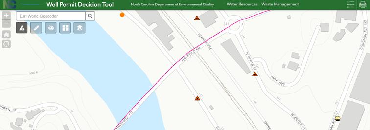
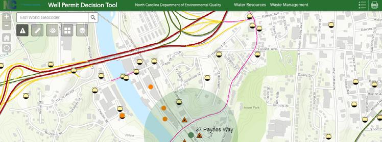
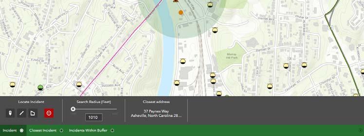
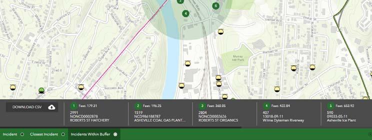
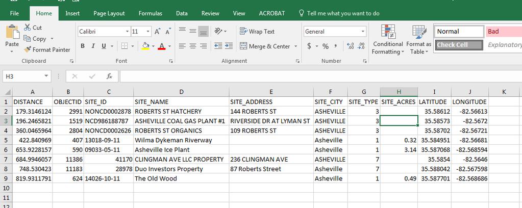
5 DEQ ArcGIS Online Departmental ArcGIS Online Website Launch of new Applications and Data Services Documentation Links to other Division/Program data layers 9 Well Permit Decision Tool Project 5
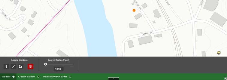
6 Legislative Directive Regulatory Reform Act of 2013 (SL ) Environmental Management Commission shall adopt rules to provide for notice of known contamination to applicants who seek to construct new private drinking water wells Rules shall Govern permits issued for private drinking water wells for circumstances in which the local health department has determined that the proposed site for a private drinking water well is located within 1,000 feet of a known source of release of contamination; Provide notice and information of the known source of release of contamination; and Share any known risk of issuing a permit for the construction and use of a private drinking water well on such a site. Well Permitting Decision Tool Project An Inter-Agency Team to develop the necessary tools and rules to address SL revisions to NC GS Team includes members from DWM, DWR, DHHS and Local County Programs Draft a definition of Known Source of Release of Contamination Compilation of sites from both DWM and DWR that fall under the definition A geographically based Tool built on an ArcGIS Online (AGOL) platform 12 6
7 Draft Definition Known source of release of contamination means a location where any of the following activities, facilities, or conditions have been documented by the Department of Environmental Quality or a local health department: Groundwater contamination incidents arising from agricultural operations, including application of agricultural chemicals pursuant to 15A NCAC 02L; Groundwater contamination associated with the construction or operation of injection, monitoring, and other wells subject to permitting under the Well Construction Act (G.S ) and 15A NCAC 02C; Groundwater contamination associated with the operation of non- discharge, discharge (NPDES) facilities, land application of animal waste, and other activities subject to permitting under G.S Releases of hazardous waste or constituents that currently exceed the Groundwater Quality Standards listed in 15A NCAC 02Lat facilities governed under G.S. 130A-294; Dry-Cleaning Solvent Cleanup sites regulated under G.S ; Pre-regulatory landfills and Inactive hazardous substance or waste disposal sites governed under the Inactive Hazardous Sites Act of 1987 (North Carolina General Statute 130A-310 et seq); Solid waste facilities subject to 15A NCAC 13B that have monitoring wells with exceedances of the Groundwater Protection Standards as defined in 15A NCAC 13A.1634(g) and (h); Releases of petroleum and hazardous substances subject to G.S through ; Sites that fall within the authority of the Brownfields Program as defined by NC General Statute 130A, Article 9 Part 5; or Contamination associated with pollution sources in soils or other sites known or suspected to have exceeded the Groundwater Quality Standards listed in 15A NCAC 02L. Well Permitting Decision Tool Create an easy to use online tool to help Well Permitting Programs: Identify well sites that need notice under G.S (e1) Inform well owner about potential risks Recommend additional sampling to well owner Use Requirements A conversation starter NOT a definitive map of all contaminated groundwater Be publicly available 7
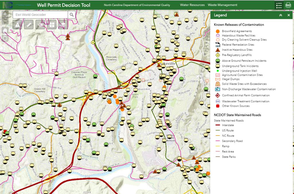
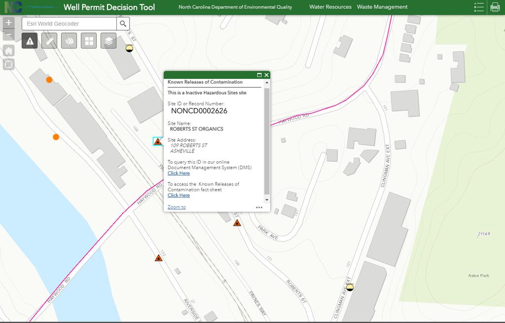
8 Geodatabase Schema DWM Known Releases of Contamination Site ID Site Name Site Address Site Type Date of Update Latitude Longitude DWR 15 Demonstration Well Permit Decision Tool Application Demo 8
9 Amy Axon North Carolina Department of Environmental Quality Division of Waste Management Superfund Section Hydrogeologist (919)

10 3/21/
11
12
13 25 13
14 27 14