Sustainable Fisheries GIT: Oyster Restoration Progress Update
|
|
|
- Shanna Banks
- 5 years ago
- Views:
Transcription
1 December 2018 Sustainable Fisheries GIT: Oyster Restoration Progress Update Stephanie Westby, NOAA Alicia Logalbo, U.S. Army Corps of Engineers
2 1 Overviw of Oyster Restoration Framework
3 Through the Chesapeake Bay Watershed Agreement, the Chesapeake Bay Program has committed to Goal: Sustainable Fisheries Outcome: Oyster Restoration Continually increase finfish and shellfish habitat and water quality benefits from restored oyster populations. Restore native oyster habitat and populations in 10 tributaries by 2025 and ensure their protection.

4 Chesapeake Bay Oyster Metrics State and Federal agencies, plus consulting scientists, developed Bay-wide, consensus definition of a restored reef and a restored tributary per the Chesapeake Bay Agreement Oyster Outcome. Called Oyster Metrics or GIT Metrics On-the-ground restoration is now planned & built to meet these Metrics; monitored relative to them.
5 Key Steps for Tributary Restoration Develop GIS geodatabase of spatial data Survey and characterize the river bottom Survey and characterize existing oyster population Define 100% of currently restorable oyster habitat ( CROH ) Set a restoration target (50% to 100% of CROH ) Draft a tributary restoration plan ( Blueprint ) Identify funding Implement and track restoration work Monitor success
6 State-specific Updates All numbers are PRELIMINARY; end-of-year accounting underway
7 2 Progress in Maryland
8 MD Target Tributaries for Large-Scale Oyster Restoration Choptank Complex Harris Creek Tred Avon St. Mary s River Little Choptank Manokin River
9 MD Oyster Restoration Workgroups Sustainable Fisheries Goal Implementation Team Community Consultants MD Interagency Oyster Restoration Workgroup Scientific Consultants
 $28.")
10 Harris Creek- Restoration Status Started in acres 2.49 billion spat-on-shell (produced by U of MD & Chesapeake Bay Foundation) $28.56 million 3-year-old reefs monitored in 2015, 2016, 2017; 2018 underway Initial restoration complete
 met higher, target oyster density &")
11 Harris Creek Monitoring Results % (55 of 56 restored reefs monitored) met minimum threshold oyster density & biomass 75% (42 of 56 restored reefs monitored) met higher, target oyster density & biomass
12 Harris Creek- Monitoring Results Stone base reefs Stone base reefs Stone base reefs Shell base reefs

13 Harris Creek: Reference Reef (untreated)

14 Harris Creek: Seed-Only Reef

15 Harris Creek: Stone-Base Reef with Seed
.")
16 Harris Creek Mature oysters are found in quantity on stone substrate in Harris Creek. Stone in other MD tributaries has not yet been monitored (not yet three years old). Photo by Oyster Recovery Partnership, 2017

17 Harris Creek Harris Creek alone is the largest sanctuary oyster restoration project in the United States; likely the world. Scientists/ resource managers have visited from: China Denmark New Zealand The Australia Netherlands Germany The United Kingdom
 In 2019, we can reach 50-51% CROH (343+ acres) by using seed only technique, without constructing remaining planned substrate acres.")
18 Little Choptank River Original goal in plan = 440 acres (65% of CROH ) acres restored to date (1.64 billion seed; $21.44 million) In 2019, we can reach 50-51% CROH (343+ acres) by using seed only technique, without constructing remaining planned substrate acres. Initial restoration complete Planned restoration
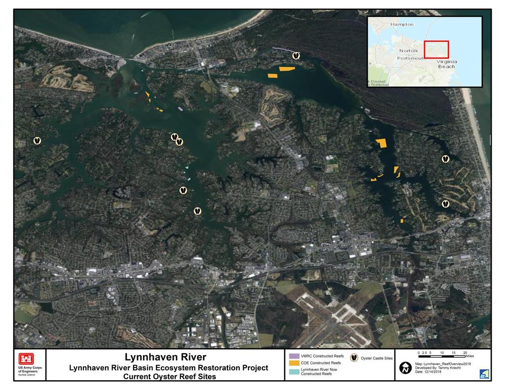
 In 2019, we can reach XX% CROH (XX acres) just by using seed-only")
19 Little Choptank River Original goal and plan = 440 acres, or XX% of CROH XX acres now complete (XX billion seed; $XX) In 2019, we can reach XX% CROH (XX acres) just by using seed-only technique
 2019: will seed <5 remaining unseeded acres. No funding currently available for additional reef construction.")
20 Tred Avon River 2018: USACE- Baltimore built 4.25 acres from mixed shell (scallop, conch, clam shell) 83 acres now complete (416 million seed; $5.26 million). Goal = 147 acres (59% CROH) 2019: will seed <5 remaining unseeded acres. No funding currently available for additional reef construction. Initial restoration complete Planned restoration
21 St. Marys River (recommended tributary) GIS geodatabase established St. Mary s River Oyster population survey currently wrapping up Workgroup has drafted a plan (numbers may change slightly pending final survey results) Oyster plantings to start summer 2019
22 Manokin River (recommended tributary) GIS geodatabase established Oyster population survey winterspring 2019 Manokin River Oyster plantings may start as early as summer 2019

23 3 Progress invirginia

24 Virginia Target Tributaries for Large-Scale Oyster Restoration Great Wicomico Piankatank Lower York Lynnhaven Lafayette
25 Virginia Oyster Restoration Workgroups Sustainable Fisheries Goal Implementation Team Hampton Roads Workgroup Virginia Interagency Oyster Team (NOAA and Corps Co-chair Bay Program goal discussions) Western Shore Workgroup Lynnhaven Lafayette Piankatank Great Wicomico Lower York


26 Virginia Oyster Restoration Workgroups Members include:

27 Lafayette River Plan developed in 2017 Restoration work completed in 2018! Goal: 80 acres Actual: 81.1 acres (48 acres relict reefs; 22.5 acres older restoration projects; 10.6 acres in 2017 & 2018)

28 Lafayette River 2018 reef construction: 6.1 acres Substrate placed in stripes across reef area; then seeded Crushed concrete, shell, stone; 12 high Elizabeth River Project reef construction funded by EPA & NOAA; Chesapeake Bay Foundation seeding funded by EPA & NFWF Workgroup now developing coordinated monitoring.

29
: Restoration Goal:")

30 Lynnhaven River In 2018, the Workgroup finalized the Lynnhaven Oyster Restoration Tributary Plan (Blueprint): Restoration Goal: 152 acres 54.6 acres of restoration reefs already constructed; 36 acres of natural, intertidal reefs Restoration remaining: 61.4 acres
31
 by 2020. VMRC plans to construct 10 acres of substrate reefs with NOAA funding.")
32 Lynnhaven River Restoration Planned for 2019 Planned 2019 Restoration Efforts: Chesapeake Bay Foundation and Lynnhaven River Now just received $400,000 NFWF grant to build 5.25 acres of substrate reefs (likely crushed concrete) by VMRC plans to construct 10 acres of substrate reefs with NOAA funding. Corps and the City of Virginia Beach plan to construct up to 8 acres of reef habitat, as Phase 1 of the Lynnhaven River Basin Ecosystem Restoration Project.

33 INSERT MAP

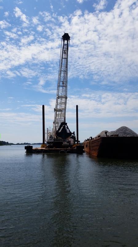
34 Piankatank River 2018 Workgroup developed draft plan Restoration goal = 437 acres Completed: 278 acres (75 restoration projects acres premet reefs) Restoration remaining: 160 acres 2018 construction: VMRC/ TNC constructed 15+ acres at three reef sites Crushed stone 2 in diameter; 3 high $200,000 project VCU planted with approximately 7 million spat-on-shell

35 Piankatank River Map showing constructed, planned, and potential reefs. 2019: VMRC plans to build reefsacreage depends on funding. USACE/VMRC plans to build 165 acres, pending funding.
36 Piankatank River Monitoring Update Substantive amount of previously constructed reefs that already meet GIT metrics verified through VMRC monitoring program ROV footage of 2017 constructed 25-acre Burton s Point Reef in the Piankatank River

37 Great Wicomico In 2018, NOAA, with Workgroup info, developed a geodatabase of available spatial information for the River. This will serve as the basis for planning efforts. Previous restoration projects: in 2003 and 2004, the Corps/VMRC used shell to create 85 acres of reef habitat. Reef rehabilitation and adaptive management has occurred over time. In 2018, USACE funded VIMS/CNU to assess the previously constructed USACE restoration reefs relative to Oyster Metrics success criteria. Results will inform restoration planning.

38
39 Great Wicomico Preliminary Monitoring 2018 Update VIMS has completed the patent tong sampling some of reefs are now over 14 years old. Overall general status of previously constructed restoration reefs is promising On first look, we anticipate reefs 1-4, 8, 9, and 16 to meet or exceed GIT metrics Reefs appear to have lost acreage potentially due to anoxic conditions Reefs repaired in 2015 appear to be in good condition and anticipated to meet or exceed GIT metrics Evidence of reef impacts/potential poaching at edges of Reefs and 13

40 Lower York 2018: NOAA, with Workgroup data, developed geodatabase of available spatial information for the River. This will serve as the basis for planning efforts. 2018: NOAA conducted sonar survey and developed a habitat assessment. Workgroup will use to determine currently restorable oyster habitat and set a restoration goal for the River. 2019: Workgroup to determine upstream and downstream river extent; begin planning.
41 4 Summary of Progress Bay- Wide Progress
42 What is our Bay-wide progress? Harris Creek Tred Avon Maryland Virginia Selected Tributaries: Harris Creek Little Choptank Tred Avon St Mary s (recommended) Manokin (recommended) Selected Tributaries: Lafayette Lynnhaven Piankatank Great Wicomico Lower York Great Wicomico Piankatank Lower York St. Mary s River Breton Bay Little Choptank Lafayette Lynnhaven
; two more in draft form (St Marys, Piankatank).")
43 What is our Bay-wide progress? Ten tributaries selected/ recommended Bay-wide. Workgroups completed five restoration blueprints (Harris, Tred Avon, Little Choptank, Lafayette, Lynnhaven); two more in draft form (St Marys, Piankatank). Initial restoration complete in two tributaries. Approx: 913 acres of restoration projects Bay wide (770 acres MD; 140 acres in VA) Monitoring phase started in three tributaries (Harris; Little Choptank; Tred Avon); coordination work for starting in Lafayette. 98% of MD monitored reefs meet Oyster Metrics minimum threshold success criteria three years post restoration.
44 Discussion Presentation template by SlidesCarnival.