Alloa Reservoir, Pumping Station and Feedermain Municipal Class Environmental Assessment ENVIRONMENTAL STUDY REPORT
|
|
|
- Samuel Preston
- 5 years ago
- Views:
Transcription

1


2 Municipal Class Environmental Assessment ENVIRONMENTAL STUDY REPORT Prepared for: The Regional Municipality of Peel Environment, Transportation & Planning Services 10 Peel Centre Drive Brampton, Ontario L6T 3Y3 Prepared by: AECOM Corbloc Building 80 King Street, 2 nd Floor St.Catharines, Ontario L2R 7G1 December 2008 # 96777
3 TABLE OF CONTENTS EXECUTIVE SUMMARY 1. INTRODUCTION BACKGROUND FORMAT OF THIS REPORT CLASS ENVIRONMENTAL ASSESSMENT PROCESS MUNICIPAL CLASS EA PLANNING PROCESS CONSULTATION AND COMMUNICATIONS PROGRAM ALLOA RESERVOIR,PUMPING STATION AND FEEDERMAIN CLASS EA PLANNING SCHEDULE PHASE 1: PROBLEM IDENTIFICATION PROBLEM STATEMENT STUDY AREA LOCATION EXISTING LAND USES OFFICIAL PLAN DESIGNATIONS AND FUTURE LAND USES Region of Peel Official Plan City of Brampton Official Plan Town of Caledon Official Plan SOCIO-ECONOMIC ENVIRONMENT NATURAL HERITAGE FEATURES Watercourses Wetlands Woodlots Topography, Physiography, Geology and Groundwater Conditions Archaeological and Built Heritage Resources SERVICING AND PLANNING Places to Grow Plan Provincial Policy Statement Greenbelt Planning Area Niagara Escarpment Plan City of Brampton Development Allocation Growth Management Strategy Town of Caledon Local Improvement Process MOE Guideline D-5, Planning for Sewage and Water Services i
4 5. PHASE 2: ALTERNATIVE SOLUTIONS TO THE PROBLEM REGION OF PEEL WATER AND WASTEWATER SERVICING MASTER PLAN RESERVOIR /PUMPING STATION AND FEEDERMAIN DESIGN BASIS Reservoir Pumping Station Feedermain RESERVOIR AND PUMPING STATION AND FEEDERMAIN SITING GUIDELINES ALTERNATIVE FEEDERMAIN ROUTES CONSTRUCTION METHODS Feedermain Construction Methods Reservoir Construction Methods EVALUATION METHODOLOGY DEVELOPMENT OF EVALUATION FRAMEWORK AND CRITERIA USE OF DESCRIPTIVE INFORMATION AND QUALITATIVE EVALUATION EVALUATION OF FEEDERMAIN ROUTES NATURAL ENVIRONMENT EVALUATION Approach to Evaluation Field Investigations Route Evaluation TECHNICAL EVALUATION SOCIAL/CULTURAL EVALUATION LEGAL/JURISDICTIONAL EVALUATION ECONOMIC/FINANCIAL EVALUATION EVALUATION SUMMARY EVALUATION OF RESERVOIR AND PUMPING STATION SITES NATURAL ENVIRONMENTAL EVALUATION TECHNICAL EVALUATION SOCIAL/CULTURAL EVALUATION LEGAL/JURISDICTIONAL EVALUATION ECONOMIC/FINANCIAL EVALUATION EVALUATION SUMMARY PREFERRED FEEDERMAIN ROUTE AND RESERVOIR / PUMPING STATION SITE RATIONALE FOR ROUTE ii
5 Coordination with Future Mississauga Road Improvements RATIONALE FOR SITE A MITIGATIVE MEASURES CONSTRUCTION RELATED IMPACTS Aquatic Habitat Compensation Erosion and Sediment Control Tree Retention and Excavation Adjacent to Retained Trees Tender Documents and Field Review REVIEW AGENCY APPROVALS Ministry of the Environment Credit Valley and Toronto and Region Conservation Authorities Ministry of Natural Resources Ministry of Culture Town of Caledon Utilities CONSULTATION AND COMMUNICATION PROGRAM PUBLIC AND AGENCY NOTIFICATION PUBLIC OPEN HOUSE NO.1 MAY 15, PUBLIC OPEN HOUSE NO.2 JUNE 18, REVIEW AGENCY,AREA MUNICIPALITY AND STAKEHOLDER CONSULTATION City of Brampton Town of Caledon Credit Valley Conservation Toronto and Region Conservation Authority Ministry of Transportation Utilities First Nations Ministry of Culture Peel District School Board RECOMMENDATIONS AND CONCLUSIONS iii
6 LIST OF FIGURES FIGURE 1.1 PEEL REGION WATER SERVICING MASTER PLAN... 3 FIGURE 1.2 PRELIMINARY SERVICE AREA... 4 FIGURE 2.1 OVERVIEW OF THE MUNICIPAL CLASS ENVIRONMENTAL ASSESSMENT PROCESS... 7 FIGURE 2.2 OVERVIEW OF THE CONSULTATION &COMMUNICATIONS PROGRAM FIGURE 4.1 STUDY AREA SIGNIFICANT LAND USES FIGURE 4.2 STUDY AREA NATURAL HERITAGE FEATURES FIGURE 4.3 GREATER GOLDEN HORSESHOE GROWTH PLAN URBAN GROWTH CENTRES FIGURE 5.1 TOPOGRAPHICAL REVIEW FOR POTENTIAL RESERVOIR LOCATIONS FIGURE 5.2 ALTERNATIVE FEEDERMAIN ROUTES AND RESERVOIR AND PUMPING STATION SITES FIGURE 5.3 TYPICAL PUMPING STATION,RESERVOIR AND FEEDERMAIN SCHEMATIC FIGURE 8.1 ALTERNATIVE RESERVOIR AND PUMPING STATION SITES FIGURE 9.1 PREFERRED FEEDERMAIN ROUTE FIGURE 9.2 PREFERRED RESERVOIR AND PUMPING STATION SITE LIST OF TABLES TABLE 5.1 ALTERNATIVE RESERVOIR AND PUMPING STATION SITES TABLE 5.2 ALTERNATIVE FEEDERMAIN ROUTES TABLE 6.1 EVALUATION FRAMEWORK COMPONENTS TABLE 6.2 CRITERIA FOR EVALUATING ALTERNATIVE SOLUTIONS TABLE 7.1 FEEDERMAIN WATERCOURSE CROSSINGS TABLE 7.2 SUGGESTED WATERCOURSE CROSSING METHOD TABLE 7.3 NATURAL ENVIRONMENTAL EVALUATION OF ALTERNATIVE FEEDERMAIN ROUTES TABLE 7.4 TECHNICAL EVALUATION OF ALTERNATIVE FEEDERMAIN ROUTES TABLE 7.5 SOCIAL/CULTURAL,LEGAL/JURISDICTIONAL AND ECONOMIC/FINANCIAL EVALUATION OF ALTERNATIVE FEEDERMAIN ROUTES TABLE 7.6 OVERALL EVALUATION SUMMARY OF ALTERNATIVE FEEDERMAIN ROUTES TABLE 8.1 COMPARATIVE EVALUATION OF RESERVOIR AND PUMPING STATION SITES TABLE 10.1 POTENTIAL CONSTRUCTION RELATED IMPACTS AND ASSOCIATED MITIGATION MEASURES iv
7 APPENDICES Appendix A Appendix B Appendix C Appendix D Appendix E Appendix F Appendix G Appendix H Appendix I Overview of the Municipal Class EA Planning Process Planning Information Photos - Land Use Features Photos - Watercourse Crossings Geotechnical / Hydrogeological Investigations Archaeological and Built Heritage Assessments Agricultural Impact Assessment Communications & Consultation Net Effects Analysis v
8 LIST OF ACRONYMS AIA ANSI Class EA CNR CVC DFO EA EAA ELC EPBM ESA ESR GGH GTA ha HADD HGL igpm l/s m masl MEA ML mm Agricultural Impact Assessment Area of Natural or Scientific Interest Municipal Class Environmental Assessment Canadian National Railway Credit Valley Conservation Authority Department of Fisheries and Oceans Environmental Assessment Environmental Assessment Act Ecological Land Classification Earth Pressure Balance Tunnel Boring Machine Environmentally Sensitive Area Greater Golden Horseshoe Greater Toronto Area hectare Harmful Alteration, Disruption or Destruction of Fish Habitat Hydraulic grade line imperial gallons per minute litres per second metre metres above sea level Ontario Municipal Engineers Association mega litre millimetre vi
9 MNR MTO NHIC OMB OPA PDSB POH Province PSW PTTW Region TRCA TWL Ontario Ministry of Natural Resources Ontario Ministry of Transportation Natural Heritage Information Centre Ontario Municipal Board Official Plan Amendment Peel District School Board Public Open House Province of Ontario Provincially Significant Wetland Permit to Take Water Region of Peel Toronto and Region Conservation Authority Top Water Level File location: P:\eo\2007 pn over 96615\ Peel - Alloa FM-PS-Reservoir EA\03-Report\ESR\FINAL - Dec 2008\Alloa ESR FINAL V3.doc vii
10 EXECUTIVE SUMMARY A. BACKGROUND The Region of Peel (the Region), through their consultant AECOM (formerly Earth Tech Canada Inc.), has completed a Municipal Class Environmental Assessment (Class EA) for the routing of a proposed 1200 mm diameter feedermain, and siting of a proposed 25 mega litre (ML) reservoir and pumping station (see map). The Region s 1999 Water and Wastewater Master Plan, and associated April 2002 Addendum, identified the need to construct the Alloa reservoir, pumping station and feedermain to meet municipal water demands from future development of the City of Brampton North West Development Area. The Master Plan provides a planning framework for the development of water and wastewater servicing infrastructure to accommodate approved future growth within Peel Region in accordance with the Region s Official Plan 1. In September 2007, the Region completed its Water and Wastewater Servicing Master Plan Update, 2 which confirmed the timing and size of the proposed pumping and reservoir storage capacity increase. Carrying forward with its Master Plan recommendations, the Region has completed this Municipal Class EA Environmental Study Report (ESR) to identify the preferred location for the Alloa reservoir, pumping station and associated feedermain. The preferred feedermain alignment (see above map) will extend northerly from an existing feedermain at the intersection of the Mississauga Road and Bovaird Drive (formerly Highway 7) to the new Alloa reservoir and pumping station located on the north side of Mayfield Road (Town of Caledon). The proposed works are to be in place by 2014 and, as mentioned above, will address water supply servicing 1 Region of Peel Official Plan, November Region of Peel Water and Wastewater Servicing Master Plan Update, Volume 1 Master Plan Class EA Report and Appendices, KMK Consultants Limited, September viii
11 demands from future anticipated development in the Northwest Brampton Development Area (West Central Peel Region). The proposed reservoir and pumping station can also be designed to service the south western part of the Town of Caledon, if approved under a Local Improvement Process. Local improvements are owner-initiated requests for municipal services and are not associated with this Municipal Class EA. Further information about the Local Improvement Process can be found in Section of this report. B. MUNICIPAL CLASS EA PLANNING SCHEDULE As the project described in this report involves the establishment of a new reservoir and pumping station (Schedule B activity), Phases 1 and 2 of the Municipal Class EA planning process apply to this study. Other Schedule B triggers include feedermain water crossings by non-trenchless methods (i.e., open cut) and the potential for feedermain alignments to be located outside of an existing road allowance or utility corridor. Based on individual project Class EA planning schedules and characteristics, proponents can voluntarily elevate their project status to a Schedule B or C planning process. As a result, recognizing the study area characteristics and the potential for impacts on the environment, the Region has elevated this project from a Schedule B to a Schedule C. By planning the project as a Schedule C, the Region is ensured the maximum level of study detail, including examination of alternative reservoir and pumping station siting options and feedermain routes, in addition to public and agency consultation and review. C. PROBLEM STATEMENT The problem statement for the Alloa reservoir, pumping station and feedermain Municipal Class EA is defined as follows: The Master Plan has identified the need for a new Zone 6 reservoir and pumping station in the vicinity of the intersection of Creditview Road and Mayfield Road, which in turn will service the Brampton Northwest Development Area. Associated with the new reservoir and pumping station is the need for a new 1200 mm diameter south to north feedermain. This feedermain will extend from an existing feedermain located at the intersection of Bovaird Drive (formerly Highway No.7) and Mississauga Road and connect to the proposed reservoir and pumping station. The proposed works are required to be in place by the end of 2014 in order to accommodate anticipated development and projected water demands within Pressure Zone 6. ix
12 In order to address the problem statement, the Region initiated this Municipal Class EA planning process in late 2006 which identifies and evaluates alternative solutions and design concepts. This Class EA ESR has been prepared to document how the proposed Alloa reservoir, pumping station and feedermain can be best located, designed and constructed. D. ALTERNATIVE SOLUTIONS TO THE PROBLEM Alternative solutions to the problem included: 1. Do Nothing; 2. Limit Community Growth; 3. Implement Water Conservation and Water Efficiency Program; 4. Expand Existing Water Supply System; and/or 5. Implement an Independent Supply from an Adjacent Water Supply System. This study carries forward with the identification and evaluation of alternative reservoir and pumping station sites and feedermain routes in support of implementing the preferred solution, i.e., Alternative 4, servicing of Pressure Zone 6 through system expansion. E. EVALUATION OF ALTERNATIVE SOLUTIONS Three alternative feedermain routes and six reservoir and pumping station sites were identified as shown on Figure 1. All alternative feedermain routes begin at the intersection of Bovaird Drive and Mississauga Road and follow either Mississauga Road north to Mayfield Road, or Bovaird Drive and Creditview Road. A third alternative followed Mississauga Road north of Bovaird Drive to Wanless Drive and then to Creditview Road. The six alternative reservoir and pumping station sites, each with a minimum useable property size of approximately 25 acres (10 ha), were then located based on a number of technical siting guidelines in the vicinity of Mayfield Road and Creditview Road. An evaluation framework was developed to include criteria that address the broad definition of the environment and comments received from relevant review agencies and stakeholders. A detailed assessment of each alternative was completed based on the evaluation components. Alternative reservoir and pumping station sites and feedermain routes were then ranked based on objective evaluations, and the preferred solutions were then presented for public and agency comment. x
13
14 F. PREFERRED FEEDERMAIN ROUTE The preferred feedermain route measures approximately 4320 m along Mississauga Road from Bovaird Drive north to Mayfield Road, and approximately 860 m along Mayfield Road from Mississauga Road east to the proposed entrance of Site A immediately east of Alloa Public School (approximately 5180 m in total length). The advantages provided by this alternative include: Moderate and mitigatable environmental impacts; Can be co-ordinated with planned Mississauga Road reconstruction; Good constructability, including low tunnel construction requirements and easily accessible construction that may be completed in the shoulder or boulevard; Low and mitigatable social/cultural impacts; and Moderate construction costs. Figure 2 presents the preferred feedermain route. Installation of the new feedermain route will be coordinated with planned road improvements on Mississauga Road from Bovaird Drive northerly to Mayfield Road. G. PREFERRED RESERVOIR AND PUMPING STATION SITE Based on the evaluation, Site A (25.7 acres) in the Town of Caledon, located approximately 200 m north of Mayfield Road and approximately 400 m west of Creditview Road, is the most preferred reservoir and pumping station site location. The rationale and advantages for the selection of this site are as follows: Fewest land use conflicts (e.g., furthest away from existing residences); Low and mitigatable social/cultural impacts; Potential future benefits for Alloa Public School, including: - Opportunity to improve access (safety) by way of a future shared reservoir/school access road; - Opportunity to compliment outdoor school activities; and - Potential future source of potable water for Alloa Public School. Highest ranked technically; xii

15
16 Does not conflict with Mount Pleasant West Secondary Plan Area 53 approved planned land uses and comprehensive transit and transportation strategy; and Most economical land cost under current market conditions for the proposed area. Figure 3 presents the preferred reservoir and pumping station site. xiv
17
18 H. MITIGATION MEASURES Impacts related to construction of the proposed reservoir and pumping station and feedermain alignment are expected to be short term and minor in nature. By incorporating proper best management practices/construction techniques and controls, including specific measures such as traffic management, dust control and limiting construction to day time in accordance with local noise by-laws, these impacts can be minimized. It is recommended that the mitigating measures further described in Section 10 of this report, and further confirmed and defined during detailed design, be employed to reduce the potential impacts during construction of the proposed works. I. CONSULTATION PROGRAM As part of the Municipal Class EA planning process, efforts were made to inform government/review agencies and the local community of the nature and scope of the project and to solicit input/comments. These steps included completion of a stakeholder scan (interviews) and a project specific consultation plan, including direct mailings and publication of Notices of Project Commencement and Public Open Houses in local newspapers. Public Open House (POH) No. 1 was held on Tuesday, May 15, 2007 at Alloa Public School. It provided an opportunity for review agencies and stakeholders to review the problem statement and preferred solution, the alternative sites and feedermain routes under consideration and proposed evaluation criteria, and to discuss their issues or concerns with Region of Peel and Earth Tech staff. POH No. 2 was also held at Alloa Public School on Wednesday, June 18, This second venue provided the opportunity for review of the evaluation of alternatives as well as the preferred feedermain route and reservoir and pumping site, construction methods and mitigation measures. In addition, meetings to explain the project and address specific issues related to construction and operations were also held with the City of Brampton, Town of Caledon, both the Credit Valley and Toronto and Region Conservation Authorities and the Peel District School Board. J. RECOMMENDATIONS This Municipal Class EA ESR ensures that the proposed Alloa reservoir, pumping station and feedermain project meets the requirements of the Environmental Assessment Act (EAA). It is recommended that: Following EA approval, the preferred feedermain route (Route 1: Mississauga Road) and reservoir and pumping station site (Site A) proceed to detailed design and remaining approvals. Required approvals to be obtained include MOE Certificates of Approval (water and air), CVC and TRCA xvi
19 Development Interference Permits, MOE Permit to Take Water (if required), MNR permit for any works occurring at feedermain water crossings, Town of Caledon site plan approvals and building permits, Hydro permits and road access permits; and The mitigation measures identified in Section 10 should be expanded upon at detailed design and implemented as part of the construction process. A preliminary evaluation of potential impacts was included in the screening, and indicates that only minor and predictable impacts, which can be addressed by the recommended mitigative measures as presented in Section 10, are expected. Public and agency notification was provided and no comments were received that cannot be adequately addressed. As a result, this project is considered to meet the requirements of the EAA. xvii
, has completed a Municipal Class Environmental Assessment (Class EA) for the routing of a proposed 1200 mm diameter feedermain, and siting of a proposed 25 mega litre (ML) reservoir and pumping")
20 1. INTRODUCTION 1.1. Background The Region of Peel (the Region), through their consultant AECOM (formerly Earth Tech Canada Inc.), has completed a Municipal Class Environmental Assessment (Class EA) for the routing of a proposed 1200 mm diameter feedermain, and siting of a proposed 25 mega litre (ML) reservoir and pumping station (see map). In 1999, the Region completed its Water and Wastewater Servicing Master Plan study 1. The Master Plan provides a planning framework for the development of water and wastewater servicing infrastructure to accommodate approved future growth within the Region in accordance with the Region s Official Plan 2. The Master Plan study was carried out in accordance with the master planning provisions of the Ontario Municipal Engineers Association (MEA) Municipal Class EA document and included public and agency consultation throughout the planning process. The Region s 1999 Water and Wastewater Master Plan and associated April 2002 Addendum, identified the need to construct the Alloa reservoir, pumping station and feedermain to meet municipal water demands from future approved development related to the City of Brampton North West Development Area. In September 2007, the Region completed its Water and Wastewater Servicing Master Plan Update 3, which confirmed the timing and size of the proposed reservoir, pumping station and feedermain. This update brings the water and wastewater infrastructure proposed in the Region s 1999 Water and Wastewater Master Plan (including KMK Consultants Limited, Region of Peel Water and Wastewater Servicing Master Plan, Region of Peel Official Plan, November Region of Peel Water and Wastewater Servicing Master Plan Update, Volume 1 Master Plan Class EA Report and Appendices, KMK Consultants Limited, September Page 1 of 95
21 Addendum) in line with recently proposed residential and employment growth targets set by the Province and area municipalities. Carrying forward with its Master Plan recommendations, the Region has completed this Municipal Class EA (ESR) to identify the preferred location for the Alloa reservoir, pumping station and associated feedermain. The preferred feedermain alignment (see above map) will extend northerly from an existing feedermain at the intersection of Mississauga Road and Bovaird Drive (formerly Highway 7) to the new Alloa reservoir and pumping station. The project will involve construction of a new 1200 mm diameter feedermain and a new 25 ML (ultimate 35 ML) reservoir and pumping station 4. The proposed works are to be in place by 2014 and, as mentioned above, will address municipal water supply servicing demands from future anticipated development in the Northwest Brampton Development Area (West Central Peel Region). If approved under a Local Improvement Process, the proposed reservoir and pumping station can also be designed to service the south western part of the Town of Caledon. Local improvements are owner-initiated requests for municipal services and are not associated with this Municipal Class EA. Further information about the Local Improvement Process can be found in Section of this report and on the Region s web site. Figures 1.1 and 1.2 illustrate the Region s water supply system, including the project study area and preliminary service area. The preferred Alloa reservoir and pumping station site and feedermain alignment are further described in Section 9 of this report Format of This Report This report was prepared to meet the requirements of the MEA Municipal Class EA planning process. The report combines all phases of the planning process under one cover and incorporates steps considered essential for compliance with the requirements of the Environmental Assessment Act in the following sections: Section 1 Provides background information, including a description of the steps which lead to the initiation of this study, as well as the format of this report. Section 2 Presents an overview of the Municipal Class EA planning process. This section also identifies the Class EA planning schedule followed for this project. 4 Pumping rates: Zone l/s (50 ML/day) and Zone l/s (5 ML/day). Page 2 of 95

22

23
24 Section 3 Identifies and describes the problem addressed in this Municipal Class EA, including supplementary background information. Section 4 Describes the project study area, including its location, existing and future land uses, socio-economic environment, natural heritage or environmental features and servicing and planning considerations. This information was also considered when reviewing alternative reservoir pumping station siting options and feedermain alignments. Section 5 Describes the findings of the 1999 Region of Peel Water and Wastewater Servicing Master Plan (including 2002 Addendum and September 2007 Update), possible reservoir/pumping station and feedermain design and siting guidelines, as well as construction methods. Section 6 Describes how the evaluation framework and criteria were developed and applied to the alternative reservoir and pumping station siting options and feedermain alignments. Section 7 Evaluates alternative feedermain routes. Section 8 Evaluates alternative reservoir and pumping station sites. Section 9 Identifies the preferred feedermain route and reservoir/pumping station site, including rationale for selection. Section 10 Describes the mitigation measures recommended to ensure that any disturbances are managed by the best available methods. Section 11 Describes public and agency consultation activities undertaken as part of this Class EA. Section 12 Presents study conclusions and recommendations. Page 5 of 95
 and its requirements to")
25 2. CLASS ENVIRONMENTAL ASSESSMENT PROCESS 2.1. Municipal Class EA Planning Process All Municipalities in Ontario, including the Region of Peel, are subject to the provisions of the Environmental Assessment Act (EAA) and its requirements to prepare an Environmental Assessment for applicable public works projects. The Ontario MEA Municipal Class Environmental Assessment document (October 2000, as amended in 2007) provides Municipalities with a five-phase planning procedure approved under the EAA to plan and undertake all municipal sewage, water, stormwater management, and transportation projects that occur frequently, are usually limited in scale, and have a predictable range of environmental impacts and applicable mitigation measures. Alloa Reservoir, Pumping Station and Feedermain Key components of Class EA planning include: consultation early and throughout the process; consideration of a reasonable range of alternatives; consideration of effects on the environment and ways to avoid or reduce impacts; systematic evaluation of alternatives; clear documentation; and traceable decision making. Figure 2.1 illustrates the process followed in the planning and design of projects covered by a Municipal Class EA, including the Alloa reservoir, pumping station and feedermain project. The figure incorporates steps considered essential for compliance with the requirements of the EAA as summarized below. Phase 1 Phase 2 Identify the problem (deficiency) or opportunity. Identify alternative solutions to address the problem or opportunity by taking into consideration the existing environment, and establish the preferred solution accounting for public and agency review and input. Page 6 of 95
26
27 Phase 3 Phase 4 Phase 5 Examine alternative methods of implementing the preferred solution based upon the existing environment, public and government agency input, anticipated environmental effects and methods of minimizing negative effects and maximizing positive effects. Document in an ESR, a summary of the planning rationale and design and consultation processes followed in the project, and make such documentation available for scrutiny by review agencies and the public. Complete contract drawings and documents, proceed to construction and operation, and monitor construction for adherence to environmental provisions and commitments. Where special conditions dictate, also monitor the operation of the completed facilities. The ESR also serves as a public statement of the decision making process followed by Municipalities in the planning and implementation of needed infrastructure. Based on the September 2007 MEA Municipal Class EA document amendment, projects are classified as either Schedule A, A+, B or C projects. Each of these classifications requires a different level of review to complete the requirements of the Municipal Class EA, and thus comply with the EAA as noted below: Schedule A Projects are limited in scale, have minimal adverse effects and include the majority of municipal water, stormwater management and sewage operations and maintenance activities. These projects are approved and may be implemented without following the Class EA planning process. Schedule A projects typically include normal or emergency operational maintenance activities where the environmental effects of these activities are usually minimal. Examples of Schedule A projects include normal or emergency operational activities and increasing pumping station capacity by adding or replacing equipment where new equipment is located within an existing building or structure. As such, these projects are pre-approved and subsequently do not require any further planning and public consultation. Schedule A+ The purpose of this Schedule is to ensure some type of public notification for certain projects that are pre-approved under the Municipal Class EA. There is no opportunity for the public to request a Part II Order (discussed below). Examples of Schedule A+ projects include watermain and sewer extensions where all such facilities are located within the municipal Page 8 of 95
28 road allowance or an existing utility corridor and involve water crossings (only by trenchless methods). Schedule B Projects have the potential for some adverse environmental effects. The proponent is required to undertake a screening process involving mandatory contact with directly affected public and relevant review agencies to ensure that they are aware of the project and that their concerns are addressed. Schedule B projects require that Phases 1 and 2 of the Municipal Class EA planning process be followed and a Project File be prepared and submitted for review by the public. If there are no outstanding concerns raised by the public and/or review agencies, then the proponent may proceed to project implementation. If however, the screening process raises a concern that cannot be resolved, then the Part II Order 5 procedure (commonly referred to as a bump-up ) may be invoked. Alternatively, the proponent may voluntarily elect to plan the project as a Schedule C undertaking. Schedule B projects generally include improvements and expansions to existing facilities where there is potential for some adverse environmental impacts. Examples of Schedule B projects include the establishment of new water supply pumping stations (where land is required) and reservoir facilities, as well as watermain extensions where such facilities are located outside of an existing municipal road allowance or utility corridor or involves water crossings by non trenchless methods (i.e., open cut). As a result, the proponent is required to proceed through a screening process (Phases 1 and 2), including consultation with those who may be affected. 5 Part II Order refers to a request to the Minister of the Environment for a project to comply with Part II (addresses Individual Environmental Assessments) of the Environmental Assessment Act. The requirement to prepare an Individual EA involves the preparation of a Terms of Reference and EA document that are submitted to the Ministry of the Environment (MOE), other government agencies and the public for review. Page 9 of 95
29 Schedule C Projects that have the potential for significant environmental effects must proceed under the full planning and documentation procedures (Phases 1 to 4) specified in the MEA Municipal Class EA document. Schedule C projects require that an ESR be prepared and submitted for review by the public. If concerns are raised that cannot be resolved, then the Part II Order 4 procedure may be invoked. Schedule C projects typically include the siting and construction of new facilities as well as major expansions (beyond rated capacity) to existing facilities, such as water or wastewater treatment plants. Appendix A further expands on the steps required to complete the Municipal Class EA planning process Consultation and Communications Program In order to properly communicate the project and solicit feedback throughout the planning process, the following activities were undertaken: Posting project milestones (i.e., notice of study commencement and public open houses, materials presented at public open houses and notice of completion) on the Region s web site ( Holding individual meetings with key affected stakeholders; Holding two public open houses; Direct mailing to affected land owners and review agencies regarding notice of project milestones; and Newspaper notices for all project milestones. Figure 2.2 summarizes the planning and consultation process followed for the Alloa Reservoir, Pumping Station and Feedermain Municipal Class EA Study. Section 11 of this report further describes the communication and consultation program. Page 10 of 95

30
31 2.3. Alloa Reservoir, Pumping Station and Feedermain Class EA Planning Schedule As the project described in this report involves the establishment of a new reservoir and pumping station (Schedule B activity), Phases 1 and 2 of the Municipal Class EA planning process as described above apply to this study. Other Schedule B triggers include feedermain water crossings by non-trenchless methods (i.e., open cut) and the potential for feedermain alignments to be located outside of an existing road allowance or utility corridor. Based on individual project Class EA planning schedules and characteristics, proponents can voluntarily elevate their project status to a Schedule B or C planning process. As a result, recognizing the study area characteristics and the potential for impacts on the environment, the Region has elevated this project from a Schedule B to a Schedule C. By planning the project as a Schedule C, the Region is ensured the maximum level of study detail, including examination of alternative reservoir and pumping station siting options and feedermain routes, in addition to public and agency consultation and review. The Municipal Class EA document requires that Schedule C projects proceed with full planning and documentation (Phases 1 to 4) and that an ESR be prepared and filed for review by the public and review agencies. Page 12 of 95
32 3. PHASE 1: PROBLEM IDENTIFICATION Alloa Reservoir, Pumping Station and Feedermain Phase 1 of the five-phase Municipal Class EA planning process requires the proponent of an undertaking (i.e., the Region) to first document factors leading to the conclusion that municipal infrastructure improvement is needed, and ultimately, develop a clear statement of the identified problem to be investigated. As such, the problem statement is the principle starting point in the undertaking of a Municipal Class EA and becomes the central theme and integrating element of the project. It also assists in setting the scope of the project. In developing the Problem Statement for the Alloa Reservoir, Pumping Station and Feedermain Municipal Class EA, the following was considered: The Region currently operates a lake based (Lake Ontario) water system that supplies municipal water (potable drinking water) to all of Mississauga, most of Brampton and specific areas within Caledon. In 2006, the Province (former Ministry of Public Infrastructure Renewal) approved its Growth Plan for the Greater Golden Horseshoe. This Growth Plan sets out the planning framework under which municipalities (including the Region) are expected to manage their local growth and development. The Growth Plan sets specific population and employment forecasts for upper tier municipalities and also prescribes density targets for intensification and greenfield development. Municipalities will be expected to review their current plans with respect to established growth projections and planning policies. The Provincial Policy Statement (Ministry of Municipal Affairs and Housing, March 2005) requires that municipalities promote efficient development and land use patterns which sustain the financial well being of the Province and municipalities over the long term and promote cost effective development standards to minimize land consumption and servicing costs 6. 6 The Provincial Policy Statement is issued under the authority of Section 3 of the Planning Act. It provides direction on matters of provincial interest related to land use planning and development, and promotes the provincial policy-led planning system (Source: Ministry of Municipal Affairs and Housing). Page 13 of 95
33 In order that these objectives may reasonably be achieved, the Provincial Policy Statement encourages municipalities to focus growth into defined settlement areas where a full level of water and sewer services are or can reasonably be made available. The Provincial Policy Statement promotes the expansion of any service in a coordinated, efficient and cost effective manner to accommodate projected needs, and requires that planning for infrastructure and public services facilities be integrated with the planning for growth so that these are available to meet current and projected needs. Section of the Provincial Policy Statement states Sufficient land shall be made available through intensification and redevelopment and, if necessary, designated growth areas, to accommodate an appropriate range and mix of employment opportunities, housing and other land use to meet projected needs for a time horizon of up to 20 years. The City of Brampton and Region of Peel have recently addressed this Statement by amending their urban service area boundaries to include the Northwest Brampton Future Urban Development Area (see Appendix B), which was also approved by the Province. In order to sustain growth in the urban settlement area, the City of Brampton requires sufficient capacity of municipal servicing to reasonably accommodate its projected approved growth for the next 20 years and potentially beyond. As part of implementing the Northwest Brampton Future Urban Development Area, the City has undertaken several secondary plan exercises (e.g. Mount Pleasant) and supporting studies. The Region of Peel s Water and Wastewater Servicing Master Plan Update (September 2007) assessed water servicing options necessary to meet future, planned and approved growth in accordance with Provincial legislation (e.g., Places to Grow Growth Plan and Greenbelt Act) and the Region s Official Plan. The Master Plan provides a listing of strategically phased projects (including this project) to meet servicing needs and to provide the necessary infrastructure as needed, while minimizing environmental impacts. Page 14 of 95
34 3.1. Problem Statement Alloa Reservoir, Pumping Station and Feedermain Based on the considerations outlined above, the problem statement for the Alloa reservoir, pumping station and feedermain Municipal Class EA is defined as follows: The Master Plan has identified the need for a new Zone 6 reservoir and pumping station in the vicinity of the intersection of Creditview Road and Mayfield Road, which in turn will service the Brampton Northwest Development Area. Associated with the new reservoir and pumping station is the need for a new 1200 mm diameter south to north feedermain. This feedermain will extend from an existing feedermain located at the intersection of Bovaird Drive (formerly Highway No.7) and Mississauga Road and connect to the proposed reservoir and pumping station. The proposed works are required to be in place by the end of 2014 in order to accommodate anticipated development and projected water demands within Pressure Zone 6. In order to address the problem statement, the Region initiated this Municipal Class EA planning process in late 2006 which identifies and evaluates alternative solutions and design concepts. This Class EA ESR has been prepared to document how the proposed Alloa reservoir, pumping station and feedermain can be best located, designed and constructed. Page 15 of 95
35 4. STUDY AREA Alloa Reservoir, Pumping Station and Feedermain The following sections describe the project study area, including its location, existing and future land uses, socio-economic environment and natural environmental features. Servicing and planning considerations are also presented. This information was considered when reviewing potential effects of alternative reservoir and pumping station siting options and feedermain route alignments Location The study area for the proposed Alloa reservoir, pumping station and feedermain is illustrated in Figure 4.1. It is comprised of lands within the northwest part of the City of Brampton corporate limits, as well as the southwest part of the Town of Caledon. It is generally bordered by lands north of Mayfield Road (Town of Caledon), to the east by lands just east of Chinguacousy Road, to the south by Bovaird Drive and to the west by lands just west of Heritage Road. Delineation of the study area limits were guided by the Region s Water and Wastewater Servicing Master Plan. The Master Plan generally locates the new Alloa reservoir and pumping station facility in the area of Mayfield Road and Creditview Road, and considers the future urban area build out and service area Existing Land Uses Within the study area existing land uses can be described as primarily rural/agricultural, open space and emerging urban. Agricultural uses include several noteworthy horse farms as well as dairy/beef and cash crop farming operations. South of Wanless Drive and east of Creditview Road, lands are fully developed and primarily include residential, commercial and institutional (e.g., schools) uses. This also includes lands south of Bovaird Drive. Specific land uses west of Creditview Road include: Alloa Public School (elementary); Several churches (e.g., Home United Church, Church of Jesus Christ of Latter Day Saints) and cemeteries; Brampton Fire and Emergency Services; Brampton Library; City of Brampton sports fields (e.g., soccer and lacrosse); Mount Pleasant GO Train station; and Peel Region Police Association. Page 16 of 95

36
37 Commercial uses (e.g., Apple Factory, Royal LePage real estate office) are located at the northwest corner of the intersection of Bovaird Drive and Mississauga Road, while a gas station is located at the southwest corner. Norval Farm Supply is located on the east side of Mississauga Road, south of the CN railway and the TransCanada high pressure natural gas pipeline crossing. Industrial uses include Pioneer Hi-Bred Limited at the northeast corner of the Mayfield Road and Mississauga Road intersection (Town of Caledon). Figure 4.1 shows significant land uses within the study area and Appendix C includes a photo log of land use features taken during a site visit on February 5, Official Plan Designations and Future Land Uses Region of Peel, City of Brampton and Town of Caledon planning information as described below (i.e., Official Plan Schedules and Amendments) are included in Appendix B. The following provides a brief overview of these planning documents as they relate to the project study area Region of Peel Official Plan Region of Peel Official Plan (November 2005) Schedules B and D (June 2007) designate those lands north of Mayfield Road (Caledon) as Prime Agricultural Area and Rural System respectively. South of Mayfield Road (Brampton), the study area lands are designated as Urban System and Northwest Brampton Urban Development Area. On June 16, 2005, Peel Regional Council adopted Regional Official Plan Amendment No.15 Amendment to Extend the Regional Urban Boundary (Northwest Brampton). The purpose of the amendment was to expand the 2021 Regional Urban Boundary to include all future Northwest Brampton Urban Development Area lands and to amend the planning horizon for the Urban System from 2021 to In December 2006, the Ontario Municipal Board (OMB) approved the urban boundary expansion. This new urban area will eventually transition from rural/agricultural to urban and is intended to primarily contain residential land uses and strategically located employment lands City of Brampton Official Plan The majority of the study area is designated North West Brampton Urban Development Area as per Schedule A of the City of Brampton Official Plan (October 2006). For the North West Brampton Urban Area, the City is completing the following Secondary Plan exercise and supporting studies: Mount Pleasant West Secondary Plan Area 53; Page 18 of 95
38 Mount Pleasant Secondary Plan Area 51; Fletchers Meadow Secondary Plan Area 44; and Huttonville North Secondary Plan Area 52. Mount Pleasant Secondary Plan Area 51 Of the four secondary plans, the Mount Pleasant Secondary Plan Area 51 was identified as the first phase of development, representing approximately 2,150 acres (870 ha). As presented at the March 5, 2008 City of Brampton Public Open House, the Vision Statement for the Mount Pleasant Community is that it will be: Planned as a signature transit-oriented community in North West Brampton that will be comprehensively designed around the principles of environmental sustainability. Furthermore, the Mount Pleasant Community planning objectives presented were: 1. Plan a well designed, mixed-use and pedestrian friendly community; 2. Establish/implement a comprehensive transit and transportation strategy; 3. Identify a sustainable natural heritage system; 4. Recognize and integrate adjacent communities (i.e., Fletcher s Meadow); 5. Ensure that the provisions of the Province s Places to Grow Plan and City s Growth Management Strategy are implemented; 6. Include appropriate cost effective and innovative planning and development standards (i.e. Alternative Design Standards) to guide development; 7. Identify an open space system for an urban environment that offers active and passive recreational facilities; and 8. Incorporate policies that encourage practical and cost effective innovations to support the development of a sustainable community (i.e., low impact development, green buildings). As per Brampton Official Plan Section 5.7, the entire City of Brampton Planning Area is designated as a site plan control area. As such, design of the Alloa reservoir and pumping station will require submission and approval of the plans and drawings during the detailed design phase under Section 41 of the Planning Act, Page 19 of 95
39 North-South Corridor Protection Area (Bram West Secondary Plan) In 2003, the Ministry of Transportation (MTO) identified a new conceptual east-west transportation corridor linking the Greater Toronto Area (GTA) to the Guelph area. This included a new north-south transportation corridor connection in the vicinity of the West Brampton/East Halton municipal boundary. Based on analysis of environmental constraints, existing and proposed land uses, travel demand and operations of the local and Provincial road network, the City of Brampton and MTO also identified a related corridor protection area located in West Brampton which applies to the area west of the Alloa reservoir, pumping station and feedermain study area. Based on its location, it is concluded that the north-south transportation corridor will not impact the feedermain route or reservoir and pumping station site selection process Town of Caledon Official Plan Study area lands within the Town of Caledon municipal boundary are designated Agricultural Area as per Schedule A of the Official Plan (December 2004). Section 5.15 Public Uses notes that public utilities, which provide services to the general community, shall be permitted in all areas designated on Schedule A (subject to provisions see Appendix B). However, as stated in Section 1.1 of this report, the purpose of this project is to service the future City of Brampton North West Development Area, not the community of Caledon specifically 7. In addition, the Town of Caledon Official Plan requires the completion of an Agricultural Impact Assessment (AIA) where agricultural land is proposed to be displaced, but an Official Plan Amendment and/or zoning by-law amendments would not be required 8. As such, the AIA (see Appendix G) was completed as part of this study and used in the evaluation of reservoir sites and development of mitigative measures. Pursuant to Section 41 of the Planning Act, R.S.O., 1990 c.p.13, Site Plan Control, The Corporation of the Town of Caledon in accordance to Section of the Town s Official Plan, designates all lands within the corporate limits of the Town of Caledon as a Site Plan Control area. Section however, states Any 7 It is recognized that the municipal water network can be extended to Caledon through projects approved under a Local Improvement Process, not associated with this Class EA see Section of this report) 8 Town of Caledon personal communication to Earth Tech, October Page 20 of 95
40 public works undertaken by any government authority are not subject to Site Plan Control, except when it is required as a condition of approval for various applications Socio-Economic Environment The study area is characterized predominantly by agricultural activities/uses, with the exception of lands south of Mayfield Road (City of Brampton) and east of Creditview Road. However, as previously stated, the study area comprising the City of Brampton lands will eventually transition from agriculture/open space to urban area 9, based primarily on residential and employment lands. Currently however, there are few major employers, cultural facilities or tourist attractions. Significant existing businesses and noteworthy agricultural operations are shown on Figure 4.1. With respect to various agricultural activities, cash crop operations include corn, soybean, cereal grains and forage crops (e.g., hay, pasture, alfalfa, etc.), while livestock operations include beef, dairy, hog, poultry and equestrian operations. The study area also contains two major agribusinesses (i.e., Pioneer Hi-Bred Limited and Norval Farm Supply) that serve the larger agricultural community. Within the study area, Bovaird Drive (east to west), Mississauga Road (north to south) and CN Rail provide the major transportation access to the Region. The CN Rail line also serves GO transit (Georgetown GO Train line) with the Mount Pleasant GO Train and bus station located in the southern part of the study area at Bovaird Drive and Creditview Road Natural Heritage Features Natural heritage features within the study area are shown on Figure 4.2 and comprise the headwaters of Etobicoke Creek, Fletcher s Creek, Huttonville Creek and Credit River tributary watercourses and their associated aquatic-terrestrial environments. These natural heritage features will be further defined through the completion of sub-watershed studies as well as aquatic and terrestrial inventories for the North West Brampton Development Area. As per Regional Official Plan Schedule A (see Appendix B-1) there are no Core Areas of the Greenlands System within the study area. Core Areas are protected under the Regional Official Plan and include: 9 It is noted that open space/environmental policy areas will still exist within the urban area, which will be regulated by applicable planning policies. Page 21 of 95

41
42 Provincially Significant Wetlands (PSWs) (Class 1-3); Alloa Reservoir, Pumping Station and Feedermain woodlands that are a minimum of 30 ha (75 acres); Environmentally Sensitive or Significant Areas (ESAs); Areas of Natural or Scientific Interest (ANSIs); habitats of vulnerable, threatened or endangered species 10 ; Escarpment Natural Areas of the Niagara Escarpment Plan; and certain specific valley and stream corridors. Both Natural Areas and Corridors of the Greenlands System and Potential Natural Areas and Corridors are interpreted as protected and shown as appropriate on area municipal Official Plans. The City of Brampton Official Plan, Schedule D (see Appendix B-2) shows that, within the study area south of Mayfield Road these include: other wetlands (Class 4-7 and unevaluated); and woodlands that range in area from 3 ha (7.4 acres) to 30 ha (75 acres). Within the study area north of Mayfield Road, there are no natural heritage features as per the Town of Caledon Official Plan, Schedule A (see Appendix B-3) Watercourses Watercourses within the study area include a number of creeks, tributaries and surface drainage features, although most have been altered due to agricultural practices and/or urban development. The majority of the study area lies within the Credit River Watershed. Most notably within the study area, Huttonville Creek 11 is located predominantly north of Bovaird Drive between Mississauga and Creditview Roads and represents the 10 Although not noted in the Region s Official Plan, according to the CVC, Huttonville Creek is identified as habitat for species of concern (i.e., threatened species). CVC correspondence, July 29, 2008 (see Appendix H-4). 11 Part of the Huttonville Creek (south of CNR) has recently undergone rehabilitation by the Credit Valley Conservation Authority (CVC) in association with Lawrence Avenue Group Ltd., Credit River Anglers Association, the Department of Fisheries and Oceans (DFO) and the Ministry of Natural Resources (MNR). Page 23 of 95
43 highest quality fish habitat, e.g., Redside Dace (Clinostomus elongatus) 12. A tributary of Etobicoke Creek is located north of Mayfield Road and tributaries of the Credit River and Fletcher s Creek are respectively located in the western and eastern portions of the study area (see Figure 4.2). The Credit Valley Conservation Authority (CVC) has jurisdiction over the three Credit River sub-watersheds within the study area, and the Toronto and Region Conservation Authority (TRCA) has jurisdiction over the Etobicoke Creek watershed. At this time only, the tributary of Etobicoke Creek is designated by a regulated flood line (TRCA). However, through the Mount Pleasant watershed studies (currently in draft), several study area watercourses have been proposed to have similar flood line designations. Appendix D includes a photo log of watercourse crossings at roads within the study area, taken during field investigations conducted on December 6, Wetlands Wetlands within the study area range in size from approximately 0.2 to 6.4 ha (approximately 0.5 to 18 acres), the largest of which is the Springbrook Wetland Complex south of Bovaird Drive, comprising a total area of approximately 12 ha (30 acres). North of Bovaird Drive, remotely sensed wetlands associated with Huttonville Creek are located on the east side of Mississauga Road. 13 These wetlands are, for the most part, considered potential wetlands as regulated by the CVC, and as noted above, are not considered PSWs. Nonetheless, the City of Brampton Official Plan policies and l (see Appendix B-2) present measures to protect these wetlands as part of the natural heritage system Woodlots Characteristic of its predominantly rural setting, the study area contains several woodlots, including hedgerows and plantations, ranging in size from 0.2 to 25 ha (0.5 to 62 acres). The City of Brampton Official Plan policies and l (see Appendix B-2) present measures to protect these woodlots as part of the natural heritage system. 12 In Ontario, the Redside Dace is considered threatened (endangered nationally) and protected under the Ontario Fishery Regulations and the Endangered Species Act, CVC correspondence, July 29, 2008 (see Appendix H-4). Page 24 of 95
44 Topography, Physiography, Geology and Groundwater Conditions Alloa Reservoir, Pumping Station and Feedermain The following section is adapted from preliminary geological and hydrogeological assessments undertaken as part of this study. The full reports are found in Appendix E. Topography Topographic elevations within the study area slope from northeast to southwest and range from 260 m above sea level (masl) at the northeastern corner of the study area to about 240 masl north of Bovaird Drive. Physiography and Geology The study area is situated within the physiographic region known as the Peel Plain 14, and as a result of the advances and retreats of the Wisconsinan glaciation, the geology is very complex. A preliminary review of subsurface conditions indicates a relatively thin capping stratum consisting of clayey till material (Halton Till) with extensive lenses of sandy soil distributed throughout. This clay till soil stratum lies atop a shale bedrock stratum (red Queenston Shale Formation) which ranges from 0 to 25 m below surface and is anticipated to be in a weathered and fractured condition near the surface zone. Groundwater Conditions: Local Aquifers and Groundwater Use Within the study area private wells are, for the most part, located along the main roads: Mississauga Road, Creditview Road, Mayfield Road, Wanless Drive and Bovaird Drive. Most of the water supply wells tap the upper portion of the bedrock, shale or limestone. The bedrock typically yields 2 to 10 imperial gallons per minute (igpm) and as such, is generally considered a poor aquifer with both low yields and poor quality. Shale groundwater usually has a high mineral content with high chloride concentrations. Geologic cross-sections show deep overburden water-bearing sediments consisting of coarse and medium sand and gravel, although this aquifer is neither continuous nor uniform. It occurs mostly in two buried bedrock valleys: along Mississauga Road north of Bovaird Drive and along Wanless Drive between Mississauga Road and Creditview Road. Its thickness however varies: in the Wanless Drive area (MOE Well No ) it is at least 13 m thick and the aquifer yield is up to 20 igpm. The top of this sand and 14 As per correspondence from the Town of Caledon, December 3, 2008 (see Appendix H-4), the study area within Caledon lies within the South Slope physiographic region. Page 25 of 95
45 gravel aquifer ranges from between about 253 masl (at Wanless Drive and Mississauga Road) to about 233 mas1 (at Wanless Drive and north of Creditview Road). Two surficial sands deposits are located on Mississauga Road and one on Mayfield Road. The sand on Mayfield Road occurs at about 1 m below ground surface. Some domestic wells tap these shallow granular deposits Archaeological and Built Heritage Resources Ten archaeological sites have been previously registered within approximately two kilometres of the study area, and due to its general physiography and local nineteenth century land use, the study area exhibits archaeological site potential. Furthermore, there are several built heritage features and cultural landscape units (e.g., 19th century homes, churches, farm complexes) within the study area, one of which, the James Clark House, is designated under part IV of the Ontario Heritage Act 15. Appendix F includes the archaeological and built heritage assessment reports Servicing and Planning The Region of Peel is considered part of the Greater Toronto Area (GTA) and includes the area municipalities of Brampton, Caledon and Mississauga. From 2001 to present, significant population change has occurred within the Region, most notably with significant growth in the City of Brampton. From 2001 to 2006, Brampton s population has increased an estimated 33.3 %, while Caledon and Mississauga populations have increased an estimated 12.7 and 9.1 % respectively 16. Furthermore, this rate of growth is expected to 15 Ontario Heritage Act, Part IV, Provincial Powers to Conserve Property of Cultural Heritage Value or Interest of Provincial Significance (Ministry of Culture, 2005) allows the Minister of Culture, in consultation with the Ontario Heritage Trust, to designate property of Provincial significance and to prohibit the demolition or removal of a building or structure on designated heritage property of Provincial significance. The Act also enables the Minister to issue a stop order with respect to any property to prevent alteration, damage, or demolition or removal of any building or structure on the property, if the Minister is of the opinion that the property may be of Provincial significance. 16 Statistics Canada, 2006 Community Profiles. Page 26 of 95
46 continue through the 2031 Regional planning period to a total population of 695,000 in Brampton 17 and 1,509,00 for the Region as a whole (see Appendix B-1). Planning guidelines and policies to ensure this project helps accommodate a portion of this anticipated growth, while also protecting the natural environment and public health, were consulted and are discussed in the following sections below Places to Grow Plan As part of its membership in the GTA, the Region of Peel is part of the Greater Golden Horseshoe (GGH) growth plan area, the fastest growing urban area in Canada. In 2006, the Province (former Ministry of Public Infrastructure Renewal) approved its Growth Plan for the Greater Golden Horseshoe which sets specific population and employment forecasts for upper tier municipalities and also prescribes density targets for intensification and greenfield development. According to Schedule 3 of the Growth Plan, the 2031 population forecast for the Region of Peel is 1,640,000, a 59% increase from 2001, while the employment forecast is 870,000, a 64% increase. Relevant excerpts of Policy 3.2.5, Water and Wastewater Systems, states that new expansion of existing municipal water systems should only be considered where: Strategies for water conservation and other water demand management initiatives are being implemented in the existing service area; and Plans for expansion or for new services are to serve growth in a manner that supports achievement of the intensification target and density targets. As shown in Figure 4.3, most of the study area is designated built-up area and designated greenfield area as per Schedule 4 of the Growth Plan, Urban Growth Centres. 17 As per the City of Brampton s 2006 Official Plan (approved in part by the Ontario Municipal Board by Order dated October 7, 2008), the projected population number for 2031 within Brampton is 758,280 (City of Brampton correspondence, November 18, 2008, see Appendix H-4). Page 27 of 95

47
48 Provincial Policy Statement As discussed in Section 3 of this report, the Provincial Policy Statement (Ministry of Municipal Affairs and Housing, March 2005) encourages municipalities to focus growth into defined settlement areas where a full level of water and sewer services are or can reasonably be made available. Section 1.6 of the Policy Statement identifies the justification for infrastructure and public service facilities: Policy states that municipal water services are the preferred form of servicing for settlement areas. The City of Brampton and Region of Peel have recently addressed this Statement by amending their urban service area boundaries to include the future Northwest Brampton Urban Development Area (see Appendix B-2), which was also approved by the Province. The Town of Caledon however (i.e., that part of the study area north of Mayfield Road), is not currently defined as a settlement area according to the definition outlined in Section 6 of the Provincial Policy Statement, but rather it is Prime Agricultural Area. According to Policy , planning authorities may exclude land from prime agricultural areas for limited non-residential uses, provided that: the land does not comprise a specialty crop area; there is a demonstrated need within the planning horizon provided for in Policy for additional land to be designated to accommodate the proposed use; there are no reasonable alternative locations which avoid prime agricultural areas; and there are no reasonable alternative locations in prime agricultural areas with lower priority agricultural lands. Since siting of the reservoir and pumping station has been recommended within the study area north of Mayfield Road, an AIA was prepared for the Town of Caledon to provide an additional source of information for their consideration as part of the approval process. This has been included as Appendix G Greenbelt Planning Area The study area is located outside of the Greenbelt Planning Area; therefore, policies contained in the Greenbelt Plan (Ministry of Municipal Affairs and Housing, 2005) do not apply to this study Niagara Escarpment Plan The study area is located outside of the Niagara Escarpment plan area; therefore, policies contained in the Niagara Escarpment Plan (Niagara Escarpment Commission, 2006) do not apply to this study. Page 29 of 95
49 City of Brampton Development Allocation Growth Management Strategy The City of Brampton has completed a Development Allocation Growth Management Strategy, which has addressed servicing allocation issues. The 2006 Development Allocation Strategy provides the City with more opportunity to manage growth using a combination of Community Block Planning and an annual development cap. An annual growth target of approximately 5,500 draft units per year is to be primarily implemented through the use of Community Block Planning and applied at the Draft Approval stage of the development process. Each Block Plan will contain a detailed staging and sequencing plan to ensure adequate and timely provision of infrastructure and services such as: schools, parks, water and sewer and roads. Additionally, Community Block Planning will provide the basis for managing direction of growth (annual allocation) based on quality and priority criteria. The Northwest Brampton Area population specifically, is expected to grow from 400 in 2006 to 75,000 people in Phase 1 urban development will likely take place within the inverted L formed by the intersection of Mississauga Road and Mayfield Road. The development is not expected to start before Town of Caledon Local Improvement Process The part of the study area within the Town of Caledon is currently serviced by private individual well and septic systems. Over the past several years, landowners located in the southern part of Caledon have contacted the Region regarding the provision of municipal water servicing. Currently there are policies that do not allow the servicing of lands outside of an approved urban service area boundary without petition for local improvements 19. Provincial legislation however, (i.e., Provincial Policy Statement) does allow one to service areas to correct problems. 18 Source: Presentation on Growth Management and Places to Grow, Brampton Real Estate Board Workshop, November 23, Local improvements are owner-initiated requests for municipal services administered pursuant to the Municipal Act, The Act offers communities a fair and impartial process to obtain municipal services by sharing the costs with the municipality. Page 30 of 95
50 Currently, property owners within the Town of Caledon may apply for a local improvement 20, and Region staff will issue a petition if the project has at least three benefiting properties and is technically and financially feasible. If the petition is sufficient (i.e., at least two-thirds of the benefiting properties have signed in favour, and the properties in favour represent at least one-half of the assessed property value) and the project is approved by Regional Council, the project will proceed to design and construction. The Region s process for reviewing and accepting local improvement requests is approximately one year. As a result of local improvement requests, any potential servicing for the Town of Caledon from the proposed Alloa reservoir would require additional pumping station capacity and a smaller dedicated watermain MOE Guideline D-5, Planning for Sewage and Water Services MOE Guideline D-5, Planning for Sewage and Water Services (August 1996), encourages municipalities to accommodate expected growth by planning for water (and sewage) services which maintain or enhance the quality of the environment. As such, it notes that development of partial services (i.e., the provision of municipal water services in the absence of municipal sewer services) will generally be discouraged. However, local circumstances such as the existing means and quality of servicing and physical constraints to servicing will be considered in determining whether partial services may be appropriate. 20 Further information can be obtained from the Region of Peel Local Improvements website for watermain projects: The Region remains neutral on all local improvement requests. The Region does not solicit municipal services, nor does the Region encourage or discourage owners from signing a valid petition. Page 31 of 95
51 5. PHASE 2: ALTERNATIVE SOLUTIONS TO THE PROBLEM 5.1. Region of Peel Water and Wastewater Servicing Master Plan The 1999 Region of Peel Water and Wastewater Servicing master plan (including 2002 Addendum) and 2007 Update identified and evaluated the following alternative water supply planning solutions: 1. Do Nothing; 2. Limit Community Growth; 3. Implement Water Conservation and Water Efficiency Program; 4. Expand Existing Water Supply System; and/or 5. Implement an Independent Supply from an Adjacent Water Supply System. Based on the results of the evaluation, Alternative 4: Expand Existing Water Supply System, in combination with Alternative 3: Implement Water Conservation and Water Efficiency Program, was identified as the preferred solution for the Region s water supply system. This preferred solution (i.e., Alternative 4: Expand Existing Water Supply System) was further defined by the identification of several water supply system expansion projects that are to be implemented over the Master Plan planning period (2031). Specific to this study, the Master Plan identified the need for an extension of the water supply / transmission system from an existing feedermain at the intersection of Mississauga Road and Bovaird Drive northerly to the proposed Alloa reservoir. As part of this Municipal Class EA study, the evaluation of alternative solutions was reviewed considering current conditions, including recent water system modeling. Based on this review, no significant changes in the service area were noted and as a result, Alternative 4 (in combination with Alternative 3) continues to be the preferred solution. As a result, this study carries forward with the identification and evaluation of alternative reservoir and pumping station sites and feedermain routes in support of implementing the preferred solution, i.e., Alternative 4, servicing of Pressure Zone 6 through system expansion Reservoir / Pumping Station and Feedermain Design Basis The conceptual design of the proposed Alloa reservoir, pumping station and feedermain was completed based on the technical criteria contained in the following Region of Peel reports: Water & Wastewater Servicing Master Plan for the Lake Based System (May 1999); Page 32 of 95
52 Water & Wastewater Servicing Master Plan for the Lake Based System Appendices (May 1999); Addendum to Water & Wastewater Servicing Master Plan for the Lake Based System (April 2002); Facilities Management Plan: South Peel Water Supply System Reservoirs & Pumping Stations (2002); and Water & Wastewater Servicing Master Plan Update (September 2007). It should be noted that the proposed works (i.e., this project) are described in the above reports as the Creditview reservoir, pumping station and feedermain. Following completion of the above-listed reports, the project has since been renamed as the Alloa reservoir, pumping station and feedermain. The 1999 Master Plan report describes the water production and transmission infrastructure required to service the lake-based area of the Region to the 2031 planning horizon based on population forecasts and demand projections. Subsequent to completion of the 1999 report, the future infrastructure summarized in the report was modified to accommodate supply of water to York Region in accordance with an agreement executed in February This resulted in the April 2002 Master Plan Addendum. The Facilities Management Plan (2002) comprises information on the existing transmission, pumping and storage facilities and details a management plan to ensure future requirements are effectively addressed. The functionality and sizing of the proposed Alloa reservoir, pumping station, feedermain and interconnecting works are outlined in Figure 2 of the 2002 Master Plan Addendum report and in Table 6.W2.1 in the 1999 Master Plan report. Design criteria used in assessing system components are presented in Section 3.W1 in the master plan report Reservoir In the above referenced reports, the total storage requirement for the Alloa reservoir is indicated as 35.0 ML, with 25.0 ML to be provided initially and 10.0 ML to be provided by future expansion. In identifying the appropriate Top Water Level (TWL) for the new Alloa reservoir, a key reference is the schematic representation of the existing water supply system (Figure 2.W3.2 in the 1999 Master Plan report). Accordingly, a TWL of m was assumed for the proposed Alloa reservoir. Figure 5.1 provides an overview of suitable areas that were identified for the new Alloa reservoir based on ground contours/land elevation. Page 33 of 95

53
54 Pumping Station For Zone 6, three low lift pumps each with capacity of 25 ML/day, are identified to meet peak hour demands of 50 ML/day in 2031 (25 ML/day in 2011). For Zone 7, two high lift pumps each with a capacity of 5 ML/day, are identified to meet peak hour demands of 5 ML/day in 2031 (2 ML/day in 2011) Feedermain A feedermain along Mississauga Road from the future West Brampton reservoir 21 to Bovaird Drive has recently been completed and will be the southerly starting point for the feedermain and reservoir project. As such, all alternative Alloa feedermain routes will start at the intersection of Bovaird Drive and Mississauga Road and follow either Mississauga Road north of Bovaird Drive and Mayfield Road, or Bovaird Drive and Creditview Road. A third alternative would follow Mississauga Road north of Bovaird Drive to Wanless Drive and then to Creditview Road. The design flows as per the 2002 Master Plan Addendum report indicate a 900 mm diameter feedermain. A technical review of the infrastructure requirements based on current and projected water demands carried out as part of this Class EA confirms a 1200 mm diameter feedermain sizing. As a result, this study recommends a 1200 mm diameter for the proposed feedermain. The need for an even larger feedermain to provide increased capacity and reduced pump and system head requirements will be assessed during detailed design before final selection Reservoir and Pumping Station and Feedermain Siting Guidelines The following siting guidelines were applied to the study area to identify alternative locations for the proposed reservoir and pumping station site, as well as alternative feedermain routes: Technical feasibility, including consideration of study area topography, ground elevation and location of future servicing demands; Reservoir and pumping station site size / property requirements; Avoidance of watercourses and significant vegetation / woodlot removal; and 21 As identified in Earth Tech s West Brampton Reservoir, Pumping Station and Transmission Main Alignment Class EA, Construction of this reservoir and pumping station commenced in Fall Page 35 of 95
55 Feedermain alignments developed based on existing or planned roads and utility corridors, as well as new alignments generally along property lines (where possible). To provide for sufficient allowance for future requirements, a minimum useable property sizing of 25 acres (10 hectares) was assumed for the reservoir and pumping station site. All sites involve combining the reservoir and pumping station components on one site. The preferred ground elevation range for the reservoir and pumping station site alternatives was determined based on the reservoir TWL of m as indicated in the Facility Management Plan (2002). Allowing a total of approximately 2 m for freeboard, thickness of the reservoir roof slab and soil cover, the approximate ground elevation of the reservoir cover was determined to be approximately 269 m. The reservoir depth was assumed to be flexible and can allow up to 7 m water depth. Accordingly, potential reservoir sites with prevailing topographic elevations between and m were selected. Based on the application of siting guidelines, the following alternative reservoir and pumping station sites were identified as shown on Figure 5.2 and described in Table 5.1. Page 36 of 95
56

57

58

59
60 Tunnelled Sections The only surface works involved with tunnel construction are access shafts located on both sides of the water-crossing and one construction compound. Access shafts (or drilling pits) will require staging areas where construction equipment can be stored and excavated material can be brought to the surface for disposal. These staging areas will typically be 10 x 30 m and will be fenced off. Once the tunnelling or drilling operations are completed, the staging area will be restored to original condition. Since most of these areas are adjacent to or within existing road right-of-ways, or located in areas void of existing vegetation, the restoration will include re-grading and re-vegetation. Open Cut Sections For feedermain open cut sections, special care will be taken to locate the feedermain to minimize or avoid existing features. Where existing trees and/or vegetation are disturbed or lost due to feedermain construction, the area will be replanted with suitable native species to be specified during detailed design. No CVC approvals are required if the drainage crossing does not meet the definition of a watercourse (see Section of this report) Reservoir Construction Methods The following presents an overview of how reservoir construction is envisioned: Excavation to a depth of 4 to 5 m for reservoir construction, and 2.5 to 3.5 m for pumping station construction; Up to an estimated 10 trucks per hour during peak construction activity; Excavated earth stockpile storage (on-site) may be seeded to reduce dust and erosion concerns; 10 to 16 months construction duration; and Typical equipment would include backhoes, cranes, loaders, concrete trucks and other miscellaneous equipment. Figure 5.3 provides an example of typical construction that would be similar to the proposed reservoir expansion. Page 41 of 95
61
62
63
64 6.2. Use of Descriptive Information and Qualitative Evaluation Alloa Reservoir, Pumping Station and Feedermain A detailed assessment of each alternative was completed based on the previously described evaluation components. Alternative reservoir and pumping station sites and feedermain routes were then ranked based on objective evaluations. The evaluation used in this report is not based on a numerical ranking system. To ensure statistical validity, such an approach would have to strictly adhere to statistical methods that are often difficult to apply in a multi-faceted issue such as a Municipal Class EA. Instead, a descriptive or qualitative evaluation is used to consider the suitability of alternative solutions and design concepts. In this respect, the trade-offs that have been made between alternatives are described in the text of the report and these trade-offs form the rationale for the identification of the preferred solution or servicing strategy. Trade-offs involve forfeiting an advantage or accepting a disadvantage to address a higher priority consideration. For information purposes only, the alternatives have been ranked in order of preference (based on advantages/disadvantages) under the discussion with respect to each aspect of the environment. As shown on the following evaluation summary tables, the following rating symbols were used: Least preferred Most preferred Page 45 of 95
65 7. EVALUATION OF FEEDERMAIN ROUTES 7.1. Natural Environment Evaluation Approach to Evaluation Alloa Reservoir, Pumping Station and Feedermain As part of the natural environmental component of this Municipal Class EA, an assessment of the aquatic and terrestrial ecological features and functions along the alternative feedermain routes within the study area (i.e., Mississauga Road, Mayfield Road, Creditview Road, Wanless Drive and Bovaird Drive) was undertaken. The existing environmental conditions, potential impacts, appropriate mitigation measures and appropriate environmental protection recommendations have been considered and are provided in the following sections and subsections. Appendix I includes a summary of the net effects evaluation. In preparation for fieldwork and to identify the natural environment and potential constraints associated with this project, Earth Tech ecological staff reviewed a variety of existing background information sources to provide context and supporting data. Studies and information sources relevant to the study area that were reviewed include: Natural Heritage Information Centre (NHIC) database, available on the Internet at: Ontario Ministry of Natural Resources. Significant Wildlife Habitat Technical Guide (October 2000). 151p; Ontario Ministry of Natural Resources. Natural Heritage Reference Manual for Policy 2.3 of the Ontario Provincial Policy Statement (June 1999); Leet, H.T., W.D. Bakowsky, J. Riley, J. Bowles, M. Puddister, P. Uhlig, and S. McMurry. Ecological Land Classification for Southern Ontario: First Approximation and its Application. Ontario Ministry of Natural Resources, South-Central Science Section, Science Development and Transfer Branch. SCSS Field Guide FG-02 (1998); City of Brampton Draft Official Plan (April 10, 2006); City of Brampton Six Pillars Strategic Plan (2003); Credit Valley Conservation Authority fisheries and floodline data; Ontario Ministry of Natural Resources (MNR) staff input regarding fish habitat typing and/or mapping; Page 46 of 95
66 Fletcher s Meadow Secondary Plan-Land Use map and corresponding policies; and Northwest Brampton Phase 2 Urban Expansion Area Environmental Open Space Study-Final Report, Dougan and Associates (March 2005) Field Investigations Ecological field investigations were undertaken along the previously described alternative feedermain routes within the study area. Investigations took place on December 6, 2006 and involved completing aquatic habitat assessments at all potential feedermain watercourse crossings and an assessment of terrestrial features such as woodlands, wetlands, hedgerows, individual trees and riparian vegetation within a m proximity to the feedermain routes. The following describes the existing ecological field conditions along the feedermain routes. Terrestrial Two approaches were used to assess the existing terrestrial environment within the study area: 1) existing data was collected and reviewed; and 2) site investigations were completed along the route alignments to assess the degree of potential impacts from the proposed feedermain installation. This work included Rapid Assessment Ecological Land Classification (ELC) surveys of the vegetation communities where dominant vegetation species and form (i.e., forest, thicket, marsh etc.) were noted. ELC delineation followed the MNR ELC Guidelines (Lee et al, 1998). During these investigations, general observations of the physical features (i.e., topography, physiography, drainage, geology) of the area were also noted. Aquatic Habitat and Fisheries Similarly, two approaches were used to assess the existing aquatic environment within the study area: 1) existing data and mapping from CVC and MNR was collected and reviewed; and 2) site investigations were completed along the route alignments. This included an aquatic habitat assessment at each proposed watercourse crossing and involved observations pertaining to channel morphology (i.e., channelized or natural), preferred crossing location and preferred crossing method (e.g., tunnel or open cut), recommendations for classification under the Department of Fisheries and Oceans (DFO) Municipal Drains Classification System, fish presence/absence, and water conveyance status (i.e., permanent, intermittent, seasonal). Page 47 of 95

67

68

69
70 directional drill). Crossing B-9 also has fish habitat; however, based on its lower significance, it is proposed to open cut this crossing on the north side of Mayfield Road where it is not classified as a watercourse 25, subject to review and approval by agencies such as the CVC and MNR. At crossings B-6 and B-3, there is no fish habitat noted and as such, it is proposed that these crossings will also be open cut, subject to review and approval from the CVC and MNR. As opposed to directional drilling, open cut is proposed at these crossings given that tunnelling incurs significantly higher capital costs which are not warranted where no fish habitat exists. Crossings B-1, B-2 and B-4 are not considered as watercourses by the CVC and therefore, open cut at these crossings is likewise proposed. Based on the above considerations, Route 1 is moderately preferred. Route 2: There are eight crossings along Route 2. Crossing B-5 will be treated in the same manner as for Route 1. As Crossings A-5 and B-8 have fish habitat, it is proposed to open cut them subject to review and approval by agencies such as CVC and MNR. At crossings B-7, B-6, B-4, B-3 and A-4 there is no fish habitat noted. As a result, these crossings are proposed to be open cut following review and approval from the agencies. Based on the above considerations, Route 2 is least preferred. Route 3: There are five crossings along Route 3. Crossing A-1 has fish habitat and the preferred method of crossing is directional drill or tunnel. As Crossings A-3 and A-5 have fish habitat, it is proposed to open cut them subject to review and approval by CVC and MNR. At crossings A-2 and A-4, there is no fish habitat noted. However, these crossings will also be open cut after review and approval from the agencies. Based on the above considerations, Route 3 is moderately preferred. All Routes: There are no provincially significant wetlands along any of the routes. Only locally significant wetlands are present in the study area. Flood plain areas exist along each watercourse in varying extents. The aquifer system consists of mostly shale with layers of Halton till on top. In some places, there is an overlay of clay and silt deposits as well as some sand and gravel. 25 CVC correspondence, July 29, 2008 (see Appendix H-4). Page 51 of 95
71 Potential impacts to natural heritage features (e.g., woodlands, ESAs, ANSIs, and sensitive species habitat). Along the alternative route alignments the major terrestrial features consist of active agricultural corn and soya fields. No major woodlands (i.e., greater than 2 ha) are within m of the affected road allowances. However, smaller woodlots are noted at various locations within the study area as presented in Table 7.3. Vegetation communities associated with the riparian zone of all the watercourses are present. Dominant species consist of emergent grasses such as reed canary grass (Phalaris arundinacea). Riparian vegetation associated with Huttonville Creek, which is considered sensitive species habitat, consists of poplar (Populus spp.), willow (Salix spp.) and ash (Fraxinus spp.) trees, as well as hawthorn (Craetagus spp.), dogwood (Cornus spp.) shrubs and emergent grasses. There are no ESAs or ANSIs surrounding any of the routes. Page 52 of 95

72
73 7.2. Technical Evaluation Alloa Reservoir, Pumping Station and Feedermain A technical evaluation of the alternative routes is presented in Table 7.4 (end of section) and further described below. Constructability (location, depth of feedermain, soil conditions, groundwater control, highway/railway/creek crossing methods, construction time and construction equipment access). For all routes except Route 3, the feedermain will be located within the road right-of-way, with the exact placement to be confirmed during the detailed design stage. For all routes, construction will be based on typical open cut construction methods with the exception being directional drilled or tunnelled sections under significant watercourse crossings, the CNR tracks and the Trans Canada Gas pipeline. For Routes 1 and 2, no rock excavation is expected. For Route 3, rock excavation is expected for an approximately 870 m long section on Bovaird Drive (east of Creditview Road) and another approximately 600 m long section north of Bovaird Drive on Creditview Road. This is required since rock is present at a very shallow depth in these sections. For Routes 1 and 2, groundwater control will be required during construction on a section of Mississauga Road approximately 2,600 m long, north of Bovaird Drive. For Route 3, groundwater control will be required during construction on Bovaird Drive (1,370 m long section from Mississauga Road to Creditview Road) and on an approximately 600 m long section on Creditview Road, approximately 1000 m north of Bovaird Drive. A key constructability indicator is the number of crossings required for a route. The following provides the number of and a brief description of the crossings required for each route: Route 1: requires seven water crossings (only one proposed as requiring tunnelling), one railway crossing, and one Trans Canada Gas pipeline crossing. The CN railway and Trans Canada Gas pipeline crossings are expected to be completed by directional drilling or tunnelling. Route 2: requires eight water crossings (only one proposed as requiring tunnelling), one railway crossing and one Trans Canada Gas pipeline crossing. The CN railway and Trans Canada Gas pipeline crossings are expected to be completed by directional drilling or tunnelling. Route 3: requires five water crossings (only one proposed as requiring directional drilling or tunnelling), one railway crossing and one Trans Canada Gas pipeline crossing. The CN railway and Trans Canada Gas pipeline crossings are expected to be completed by directional drilling or tunnelling. In addition, Route 3 Page 54 of 95
74 also requires crossing of the Mount Pleasant GO station parking lot. It is expected that in order to avoid disturbance to the station, large scale tunnelling would be required underneath the GO station property. The proposed construction is expected to take approximately 6 months for each route. Equipment access is expected to be good for all routes. Based on the above considerations, Routes 1 and 2 are most preferred followed by Route 3 as least preferred. Compatibility with the Region s Master Servicing Plan (MSP). All three routes meet long-range MSP requirements. They are efficient and compatible with the water distribution system and can supply the required water to the future Northwest Brampton Development Area (Brampton Pressure Zone 6). Based on the above considerations, all routes are considered most preferred. Conflicts with existing utilities and impact upon existing infrastructure. All the routes involve crossing the CNR tracks, Trans Canada Gas pipeline and other utilities. No major conflicts or impact on the existing infrastructure are expected. Directional drilling or tunnelling would be required to cross the CNR tracks and the Trans Canada Gas pipeline. As mentioned previously, the Route 3 feedermain would however, also involve crossing the Mount Pleasant GO station. This may result in major conflicts with the existing operations and infrastructure. Based on the above considerations, Routes 1 and 2 are most preferred and Route 3 is least preferred. Access (maintenance access). All routes will have convenient access to feedermain chambers for inspections and/or repairs, with the exception of the section traversing the Mount Pleasant GO station (Route 3), as any chambers within the GO station property may have restricted access. Routes 1 and 2 are therefore rated most preferred while Route 3 is rated moderately preferred. Coordination with planned infrastructure improvements. Routes 1 and 2 have the potential to be combined with the future reconstruction/widening of Mississauga Road (Regional Road 1) scheduled for completion by Route 2 can also be combined with the proposed reconstruction of Wanless Drive in Lastly, Route 3 could potentially be combined with the future Page 55 of 95
75 Creditview Road realignment from Sandlewood Parkway south to Wanless Drive, which is proposed to be completed in The Alloa feedermain needs to be in place by Based on the feedermain completion or in-service date and other improvements, Route 1 is rated most preferred, Route 2 is moderately preferred and Route 3 is least preferred. Traffic management during construction. Complete road closures are not anticipated for any of the routes. During construction, traffic may be limited to one lane (both directions) for short sections. At detailed design, placement of the feedermain in the boulevard will also be explored (having regard to planned road improvements), which would allow two lanes of traffic (one lane in each direction). Construction on Bovaird Drive (Route 3) may result in significant disruption to local traffic due to highest traffic volumes amongst all routes considered for the feedermain alignment. Important Creditview Road (Route 3) traffic considerations include the use of this road by Brampton Fire and Emergency Services. Construction related traffic disruption on Mississauga Road, Mayfield Road and Wanless Road (Routes 1 and 2) are expected to be moderate. It is recommended that a traffic management plan be developed at the detailed design stage. Based on the above considerations, Routes 1 and 2 are rated as moderately preferred and Route 3 is least preferred. Page 56 of 95

76
77 Alternative Feedermain Routes Route 3 East on Bovaird Drive (formerly Highway 7) to Creditview Road North on Creditview Road to Mayfield Road Alloa Feedermain, Reservoir and Pumping Station Municipal Class Environmental Assessment Table 7.4 Technical Evaluation of Alternative Feedermain Routes Technical considerations including potential construction impacts and compatibility with existing plans and infrastructure. Alignment / routing considerations and/or constraints. Constructability Region s Master Servicing Plan Utilities and Infrastructure Access Planned Infrastructure Improvements Traffic Management Location, depth of feedermain (overburden and rock excavation), soil conditions, groundwater control, highway/railway/creek crossing methods, construction time and construction equipment access. Compatibility with the Region s Master Servicing Plan (MSP) and efficiency/compatibility with overall water distribution system. Conflicts with existing utilities and impact upon existing infrastructure. Maintenance Access Coordination with planned infrastructure improvements. Traffic management considerations during construction phase. Transmission main within road ROW for most parts except for the sections through GO Station property. Possibility of placing pipe in road shoulder or boulevard for most parts of the route outside of the GO Station property, further reducing costs (to be confirmed during detailed design stage). Typical open cut construction for most of the length. Will require rock excavation on a section approximately 870 m long on Bovaird Drive, and on another section approximately 600 m long on Creditview Road north of Bovaird Drive. Will require groundwater control during construction on Bovaird Drive (1370 m section) and for a 600 m long section on Creditview Road north of Bovaird Drive. Tunnel construction under one watercourse and CN tracks on Bovaird Drive, and under Trans Canada gas pipeline on Creditview Road. Open cut construction through four watercourses on Creditview Road. Large tunnel sections may be required in the vicinity of the GO Station so as not to disturb GO Station operations. Construction will take approximately 6 months. Generally good equipment access. Meets long range MSP requirements. Efficient/compatible with overall system. Would supply water for future development of Brampton Pressure Zone 6. Feedermain route includes crossing the existing GO Station on Bovaird Drive. Major conflicts with infrastructure and operations of the station can be expected. Tunnel construction will be required for most parts through the GO Station, under CN tracks, and under the Trans Canada gas pipeline. Feedermain will cross CN tracks, Trans Canada gas pipeline and other utilities without any major conflicts or impact on the existing infrastructure. Restricted access to feedermain chambers within the GO Station property. Potential to be combined with Creditview Road realignment from Sandlewood Parkway south to Wanless Drive in Bovaird Drive (Highway 7) has highest traffic amongst all routes considered for feedermain alignment. Construction on Creditview Road will cause inconvenience to local traffic in the area. Brampton Fire and Emergency Services Station is located on Creditview Road. Complete road closure will not be required. Limiting traffic to one lane for short sections may be required. If feedermain placed in the boulevard, two lanes of traffic may also be accommodated (determined during detailed design). A traffic management plan will be developed at the detailed design stage. Evaluation Summary Least preferred Most preferred Mostly open cut construction that may cause major inconvenience to local traffic on Bovaird Drive/Creditview Road. High tunnel construction requirements. Only five watercourse crossings (least amongst the routes); however, one would require tunneling while the other four would be open cut, two with agency approval.
78 7.3. Social/Cultural Evaluation Alloa Reservoir, Pumping Station and Feedermain A social/cultural evaluation of the alternative feedermain routes is presented in Table 7.5 (end of section) and further described below. Temporary disruption during construction. Route 1 results in local temporary disruption to approximately five businesses and three community land use 26 features. It is expected that this route will have the least amount of temporary disruption. However, as Mississauga Road and Mayfield Roads are Regional roads, traffic impacts are expected to be moderate. Route 2 results in temporary disruption to approximately six businesses and four community land use features. As the route involves Mississauga Road, Wanless Drive and Creditview Road, moderate traffic impacts are expected along this route. Route 3 results in the highest level of local disturbance and traffic impacts. There are approximately four business/commercial and eight community land use features along this route. This includes major interruptions to the Mount Pleasant GO station parking lot. In addition, on the east side of Creditview Road, a large number of residences could potentially be temporarily impacted due to dust, noise and vibrations. Bovaird Drive is expected to have the highest traffic volume of all the roads under consideration. Overall, moderate traffic impacts are expected due to relatively lower traffic volumes on Creditview Road. Based on the above considerations, Route 1 is most preferred, Route 2 is moderately preferred and Route 3 is least preferred. Private well disruption. According to the Phase 1 hydrogeological study completed for the study area (see Appendix E), as per available MOE well records, there are approximately 22, 21 and 19 wells along Route 1, 2 and 3 respectively. In the case of Route 1, the water level in some wells along Mayfield Road may be impacted during construction (i.e., dewatering). In addition, if dewatering is required at water crossing B-5 for Routes 1 and 2, then nearly six wells in the vicinity could potentially be impacted. However, for Route 3, negligible impact on private wells are anticipated. 26 Community land use features include places of worship, cemeteries, schools, recreational facilities etc. Page 59 of 95
79 Based on the above, Route 3 is rated most preferred while Routes 1 and 2 are moderately preferred. Temporary impacts on private wells and mitigation measures (e.g., supplemental hauled water) will be defined at the detailed design stage. Potential routing impacts including archaeological and historical features. Based on Stage 1 archaeological investigations (see Appendix F), it has been determined that all three feedermain routes exhibit no archaeological potential as the routes are within existing road right-of-ways and/or previously disturbed areas. A number of built heritage features and cultural landscape units are potentially affected for each of the three routes, including a house located along Route 2 which is designated under Part IV of the Ontario Heritage Act (refer to Section of this report). However, since all potentially disruptive construction work will take place within the existing road right-of-ways, and as long as appropriate mitigation measures are adopted, no impacts on built heritage features are anticipated. Based on the above considerations, Routes 1, 2 and 3 are equally preferred. Compatibility with existing land uses. Routes 1 and 2 do not result in any conflicts with existing land uses. However, Route 3 is not compatible with existing land uses as it will pass through the Mount Pleasant GO station property and accordingly result in temporary loss of parking and disruption to the parking lot traffic flow. Based on the above, Routes 1 and 2 are rated most preferred and Route 3 is least preferred Legal/Jurisdictional Evaluation A legal/jurisdictional evaluation of the alternative feedermain routes is also presented in Table 7.5 (end of section) and further described below. Potential land requirements including temporary and permanent easement requirements. The proposed feedermain would be located within existing road right-of-ways for all the routes, with the exception of Route 3 which goes through the Mount Pleasant GO station property. As such, no temporary and permanent easements have been identified at this time for Routes 1 and 2. Route 3 would, however, require easements in order to cross the Mount Pleasant GO station parking lot. Based on the above, Routes 1 and 2 are rated moderately preferred and Route 3 is least preferred. Page 60 of 95
80 7.5. Economic/Financial Evaluation Alloa Reservoir, Pumping Station and Feedermain An economic/financial evaluation of the alternative feedermain routes is also presented in Table 7.5 (end of section) and further described below. Estimated capital cost and contingency costs. The preliminary capital costs for Routes 1 and 2 are estimated at approximately $10.4 million each. For most parts along these routes, there is also the possibility of shifting the feedermain alignment to the road shoulder, thereby further reducing the costs. The preliminary capital cost for Route 3 is estimated at approximately $13.7 million. The higher costs associated with Route 3 are largely due to the feedermain section that would be constructed through the Mount Pleasant GO station property, which would likely have to be completed by tunnelling through shale formations. High costs would also arise from dewatering and rock excavation requirements on Bovaird Drive and a small section on Creditview Road. Contingency costs for Routes 1 and 2 will be moderate and are mainly due to possible dewatering requirements on Mississauga Road between Bovaird Drive and Wanless Drive. Contingency costs for Route 3 will be high due to dewatering issues, rock excavation/tunnelling in rock and the Mount Pleasant GO station property crossing. Based on the above, Routes 1 and 2 are rated most preferred and Route 3 is least preferred. Page 61 of 95

81
82 Alloa Feedermain, Reservoir and Pumping Station Municipal Class Environmental Assessment Table 7.5 Social / Cultural, Legal / Jurisdictional and Economic / Financial Evaluation of Alternative Feedermain Routes Social / Cultural Legal / Jurisdictional Alternative Feedermain Routes Temporary Disruption During Construction Dust, Noise, Vibration, Access To Property, Ability To Maintain Existing Services Traffic Management (i.e., Lane/Block Closures, Detours) Private Well Disruption Potential Routing Impacts Including Archaeological And Historical Features Compatibility with Existing Land Uses Potential Land Requirements Including Temporary And Permanent Easement Requirements Route 3 East on Bovaird Drive (formerly Highway 7) to Creditview Road North on Creditview Road to Mayfield Road Temporary disturbance to existing businesses, community facilities and residences. A total of 8 community 1 and 4 business / commercial land use features. Substantial impacts to GO Station parking lot. Large residential area east of Creditview Road may be subject to dust, noise and vibrations. Bovaird Drive close one lane to traffic. Bovaird Drive has the highest traffic amongst all routes considered for feedermain alignment. Creditview Road maintain minimum one lane of traffic. Prepare traffic management plan at detailed design. Negligible effect on private wells. Any affected residents may be supplemented by hauled water on temporary basis. Provide advance notification at detailed design and construction. No archaeological potential (all work within road ROW and/or previously disturbed areas). Stage 2/3 archaeological investigations not required. No impact anticipated to heritage / historical features. Feedermain not compatible as it will pass through GO Station property. Most of the feedermain to be located in road ROW. Temporary working easements through Mount Pleasant GO Station would be required. Typical construction related impacts can be minimized using appropriate construction techniques and mitigation measures. Provision for additional temporary parking at GO station may be required. Access to business properties will be maintained during business hours. Access to Fire Department shall be maintained at all times. Temporary disruptions to private entrances as construction passes mitigate by advance notification and scheduling. 1. Community features include schools, parks, places of worship, fire halls and government offices. Economic / Financial Construction Costs $13.7 million estimated capital costs. Higher costs associated with construction through Mount Pleasant GO station. High contingency costs due to dewatering and rock excavation requirements on Bovaird Drive and Creditview Road. Evaluation Summary Least preferred Most preferred Highest amount of temporary disruption amongst all routes (e.g., large number of residential side streets and fire department on Creditview Road and GO station parking lot on Bovaird Drive). Moderate traffic impacts. Easements required from GO Station. Lowest level of potential well interference.
83
84 8. EVALUATION OF RESERVOIR AND PUMPING STATION SITES The comparative evaluation of the alternative reservoir and pumping station sites is described below and summarized in Table 8.1 (end of section). Alternative reservoir and pumping station sites are presented in Figure 8.1 (end of section) Natural Environmental Evaluation Potential effects on air, land, water and biota. All of the potential reservoir and pumping station sites are located outside of the regulated conservation authority floodlines except for the northern part of Sites A and F, which are within the floodlines of Etobicoke Creek (TRCA watershed). Based on the Stage 1 hydrogeological study, dewatering is not anticipated at any of the sites except for a low probability of some dewatering at Site B. No other impacts to terrestrial and aquatic features are anticipated at any of the sites. Based on the above considerations, Sites C, D and E are rated as most preferred, while Sites A, B and F are moderately preferred Technical Evaluation Constructability. Constructability of the proposed reservoir and pumping station is anticipated to be good at all of the alternative sites. Based on road access, soils and site contours, all sites are considered equally preferred, with the exception of Site E which would require a large amount of fill material due to its lower topography. As such, Site E is rated as moderately preferred while Sites A, B, C, D and F are rated as most preferred. Ability to utilize existing infrastructure, utilities and facilities. Sites B and D, located in the City of Brampton, are expected to be fully serviced in the future, whereas Sites A, C, E and F, located in the Town of Caledon, are not. Sites A and E are located in close proximity to watercourses which could provide optimal emergency overflow 27, as opposed to Sites B, C, D and F which are located further from the nearest watercourse and therefore have poor emergency overflow. 27 Region of Peel reservoirs have an overflow component in the event that the reservoir becomes over pressurized when filling. The occurrence of an overflow is very rare. Page 65 of 95
85 Based on these considerations, Sites A, B, D and E are moderately preferred, and Sites C and F are least preferred. Approval requirements. Certificate of Approval and site plan approval would be required for all sites. Therefore, all sites are rated as moderately preferred Social/Cultural Evaluation Potential land use impacts including compatibility with surrounding land uses and agricultural resources. All sites located within the Town of Caledon (Sites A, C, E and F) are designated Agricultural Area as per the Town s Official Plan, and as Prime Agricultural Area as per Official Plan Amendment (OPA) 179 (OPA 179) 28. Conversely, the sites located within the City of Brampton (Sites B and D), while currently in agricultural use, are located in areas designated for future urban development. Sites located in the Town of Caledon will therefore result in the loss of agricultural lands, while sites located in the City of Brampton will result in displacing higher density urban land uses. For example, although the woodlot east of Site B would provide a natural buffer between residents and the reservoir and pumping station, Site B would result in displacement of future development necessary to support public transit (as per the Mount Pleasant West Secondary Plan Area 53), while Site D, a corner lot, would best be suited for commercial road or residential use due to access constraints. Regarding the loss of agricultural lands in the Town of Caledon, Site E would be least preferred because it would introduce a non-agricultural use in an area dominated by agriculture, whereas Sites A, C and F are in proximity to Alloa Public School, an already non-agricultural land use. Furthermore, the AIA conducted as part of this study (see Appendix G), indicates that Site E likely contains higher capability soils for agriculture than does Site A. Note however, that only Sites A and E were compared in the AIA due the fact that Site C is a corner lot with significant Regional road frontage and therefore, is not preferred from an access perspective, and Site F, although also located within the Etobicoke Creek floodplain, has poorer emergency overflow potential (further distance to nearest watercourse) as compared to Site A, and it fronts a 28 OPA 179, which updates the agricultural and rural policies in the Town s existing Official Plan, was adopted by Caledon Council in October However, it was appealed to the Ontario Municipal Board (OMB) and is therefore, not yet in full effect. While OPA 179 offers Council direction, a hearing before the OMB is anticipated in early 2009 (Town of Caledon correspondence, December 3, 2008, See Appendix H-4). Page 66 of 95
86 major east-west Regional road (i.e., Mayfield Road). Furthermore, Site A, located immediately adjacent/behind Alloa Public School, provides the potential opportunity to compliment outdoor school activities (e.g., soccer field), improve access (safety) to the school by way of a possible future shared reservoir/school access road, and provide a possible future source of potable water for the school. A review of the applicable zoning by-laws indicates that the proposed use of any of the sites to build a reservoir and pumping station would be a permitted use. Based on the above considerations, Site A is most preferred, Site B is moderately preferred, and Sites C, D, E and F are least preferred. Temporary disruption during construction (i.e., noise, dust, vibration, traffic management, detours and access to property and existing services). Sites A, B, C and F are located in relatively close proximity to Alloa Public School (i.e., adjacent to or across the road). There are also a number of single family residences in the vicinity of all the proposed sites (i.e., adjacent to or across the road), although Site A is located the furthest away from existing residences. Moderate impacts due to temporary disruption (construction) could result at all sites, although higher impacts could be expected at Sites B and E which are located in closer proximity to the adjacent residences. Based on the above, Site A, C, D and F are moderately preferred while Sites B and E are least preferred Legal/Jurisdictional Evaluation Land requirements and ownership. All sites under evaluation are privately owned (i.e., not owned by the Province or municipality). Sites A and C are owned by private citizens, Sites B and D, located in the City of Brampton, are owned by a land developer, and Sites E and F in the Town of Caledon are owned by businesses, namely Fradol Farms and Pioneer Hi-Bred Production Ltd. respectively. Since it is generally preferred that publicly owned land be acquired and all sites are privately owned, all sites are rated as moderately preferred Economic/Financial Evaluation Estimated capital and land costs. It is expected that the capital cost of constructing the reservoir and pumping station would be similar for all sites. At this time, accurate land costs are unknown; however, it is expected that Sites B and D will have Page 67 of 95
87 relatively much higher land costs due to their future urban area designation. Furthermore, Site D may have the highest potential land cost, as it is a corner lot with future commercial potential. Sites A, C, E and F have relatively much lower land costs due to their agricultural designation; however, Site A can be considered the most economical given its location immediately behind Alloa Public School with no road frontage. Based on the above considerations, Site A is most preferred, Sites C, E and F are moderately preferred and Sites B and D are least preferred. Page 68 of 95
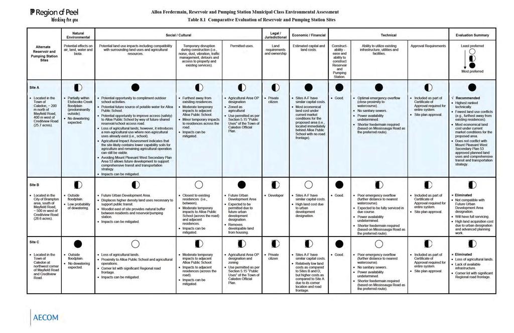
88
89 Alternate Reservoir and Pumping Station Sites Site D Located in the City of Brampton at southwest corner of Mayfield Road and Creditview Road. Site E Located in the Town of Caledon east of Creditview Road, ~ 200 m north of Mayfield Road (Lot 19, Concession 3). Site F Located in the Town of Caledon north of Mayfield Road, ~ 700 m west of Creditview Road (Lot 18, Concession 4). Natural Environmental Potential effects on air, land, water and biota. Outside floodplain. No dewatering expected. Outside floodplain. No dewatering expected. Partially within Etobicoke Creek floodplain. No dewatering expected. Alloa Feedermain, Reservoir and Pumping Station Municipal Class Environmental Assessment Table 8.1 Comparative Evaluation of Reservoir and Pumping Station Sites Social / Cultural Legal / Jurisdictional Economic / Financial Technical Evaluation Summary Potential land use impacts including compatibility with surrounding land uses and agricultural resources. Temporary disruption during construction (i.e., noise, dust, vibration, traffic management, detours and access to property and existing services). Permitted uses. Land requirements and ownership Estimated capital and land costs. Constructability - ease and ability to construct Reservoir and Pumping Station. Ability to utilize existing infrastructure, utilities and facilities. Approval Requirements Least preferred Most preferred Future Urban Development Area. Displaces higher density land uses necessary to support public transit. Corner lot within Future Urban Development Area; therefore, best suited for commercial road or residential use due to access constraints. Impacts can be mitigated. Moderate temporary impacts to adjacent residences. Impacts can be mitigated. Future Urban Development Area Expected to be permitted due to future urban development area. Developer Sites A-F have similar capital costs. High land cost due to urban development designation. Corner lot with future commercial potential. Good. Poor emergency overflow (further distance to nearest watercourse). Expected to be fully serviced in due course. Shorter feedermain required (based on Mississauga Road as the preferred route). Included as part of Certificate of Approval required for entire system. Site plan approval. Eliminated Surrounding land use compatible with Future Urban Development Area designation. Will have full servicing. Cost of acquisition highest due to urban designation, prime corner location and advanced planning work. Loss of agricultural lands. Close proximity to farm operations. Introduces a non-agricultural use in an area dominated by agriculture. Agricultural Impact Assessment indicates that proposed site likely contains higher capability soils for agriculture and remaining agricultural operation can still be viable. Impacts can be mitigated. Closest to existing residences (i.e., between and across the street). Moderate temporary impacts to adjacent residences. Impacts can be mitigated. Agricultural Area OP designation Zoned as agricultural Use permitted as per Section 5.15 Public Uses of the Town of Caledon Official Plan. Private citizen Sites A-F have similar capital costs. Relatively low land costs as compared to Sites B and D, but higher costs as compared to Site A due to its road frontage. Good. Large amount of fill material required. Optimal emergency overflow (close proximity to watercourse). No sanitary sewers. Power availability undetermined. Longer feedermain required (based on Mississauga Road as the preferred route). Included as part of Certificate of Approval required for entire system. Site plan approval. Eliminated Loss of agricultural lands. Lack of available infrastructure. Close to existing residences. Loss of agricultural lands. Proximity to Alloa Public School and agricultural operations. Regional road frontage. Impacts can be mitigated. Moderate temporary impacts to adjacent Alloa Public School and residences across the road. Impacts can be mitigated. Agricultural Area OP designation Zoned as agricultural Use permitted as per Section 5.15 Public Uses of the Town of Caledon Official Plan. Pioneer Hi- Bred Production Ltd. Sites A-F have similar capital costs. Relatively low land costs as compared to Sites B and D, but higher costs as compared to Site A due to its road frontage. Good. Poor emergency overflow (further distance to nearest watercourse). No sanitary sewers. Power availability undetermined. Shorter feedermain required (based on Mississauga Road as the preferred route). Included as part of Certificate of Approval required for entire system. Site plan approval. Eliminated Loss of agricultural lands. Lack of available infrastructure. Regional road frontage.

90
91

92
93 9. PREFERRED FEEDERMAIN ROUTE AND RESERVOIR / PUMPING STATION SITE Based on the preceding evaluations, Route 1 and Site A have been identified as the preferred solution to the problem statement. Figure 9.1 presents the recommended feedermain route including water crossings and proposed construction methods, and Figure 9.2 presents the recommended reservoir and pumping station site layout. It is noted that the development of Site A includes components such as an access road, reservoir, control building and septic system, and a stormwater management pond which would outlet to the existing ditch on Mayfield Road. The proposed stormwater management system would also be designed to accept an emergency reservoir overflow event. An emergency overflow is a very rare event that is triggered when there is an electronic communication problem between the reservoir (level transmitter) and pumping station whereby the pumps continue to run and as a result, the overflow occurs for a short period until an alarm is triggered. Alternatively, the future reservoir could also include an emergency overflow via a spillway to the tributary of Etobicoke Creek (north of Site A). This will be determined at detailed design and captured in future TRCA approvals, if required Rationale for Route 1 The preferred feedermain route measures approximately 4320 m along Mississauga Road from Bovaird Drive north to Mayfield Road, and approximately 860 m along Mayfield Road from Mississauga Road east to the proposed entrance of Site A immediately east of Alloa Public School (approximately 5180 m in total length). The advantages provided by this alternative include: Moderate and mitigatable environmental impacts; Can be coordinated with planned Mississauga Road reconstruction; Good constructability, including low tunnel construction requirements and easily accessible construction that may be completed in the shoulder or boulevard; Low and mitigatable social/cultural impacts; and Moderate construction costs Coordination with Future Mississauga Road Improvements Installation of the new feedermain route will be coordinated with planned road improvements on Mississauga Road from Bovaird Drive northerly to Mayfield Road. Page 74 of 95
94
95 9.2. Rationale for Site A Alloa Reservoir, Pumping Station and Feedermain Based on the preceding evaluation, Site A (25.7 acres) in the Town of Caledon, located approximately 200 m north of Mayfield Road and approximately 400 m west of Creditview Road, is the most preferred reservoir and pumping station site location. The rationale and advantages for the selection of this site are as follows: Fewest land use conflicts (e.g., furthest away from existing residences); Low and mitigatable social/cultural impacts; Highest ranked technically; Does not conflict with Mount Pleasant West Secondary Plan Area 53 approved planned land uses and comprehensive transit and transportation strategy; Most economical land cost under current market conditions for the proposed area; and Potential future benefits for Alloa Public School, including: - Opportunity to improve access (safety) by way of a future shared reservoir/school access road 29 ; - Opportunity to compliment outdoor school activities; and - Potential future source of potable water for Alloa Public School. 29 This is subject to future planning approvals. Page 76 of 95

96
97 10. MITIGATIVE MEASURES Alloa Reservoir, Pumping Station and Feedermain Based on the preceding evaluation of potential effects, the Alloa reservoir, pumping station and feedermain project is expected to result in some environmental impacts that are considered manageable with the implementation of various mitigative measures. The following mitigative measures are recommended to ensure that any short-term disturbances are managed by the best available methods. These will be further confirmed and defined during detailed design. Appendix I includes a summary of the net effects evaluation Construction Related Impacts Impacts related to construction of the proposed reservoir and pumping station and feedermain alignment will be short term and minor. By incorporating proper best management practices/construction techniques and controls, these impacts can be minimized. Potential construction related impacts and their associated mitigative measures are summarized in Table 10.1 below. It is recommended that these mitigating measures be employed to reduce the potential impacts during construction of the proposed works Aquatic Habitat Compensation In consultation with the CVC, TRCA and MNR, construction mitigation measures to minimize watercourse intrusion (e.g., directional drilling versus open cut, fisheries construction timing windows to avoid impacts to fish species during spawning and nursery periods, etc.) and a Fisheries Habitat Restoration and Compensation Plan (to replace lost habitat) may be developed in accordance with DFO's No Net Loss policy. This policy requires that an equivalent amount of habitat be replaced for every square metre that is lost. Therefore, compensation planning will be specific to each watercourse crossing. Habitat compensation options must be suited to the fish species inhabiting the affected area, and can include the removal of inwater debris, enhancement of substrate (gravel, cobble), creation of refuge areas (pools, boulders, overhanging vegetation) and addition of spawning beds, riparian vegetation, etc. Preference should be given to restoring aquatic habitat to original or better conditions with regard to upstream and downstream habitat, which will promote habitat consistency. Page 78 of 95
98 Erosion and Sediment Control As part of detailed design and conservation authority permit applications, both the CVC and TRCA will review the proposed erosion and sedimentation control measures 30 and dewatering options. Areas of highly erodible soils (i.e., associated with locations where there is a high potential for sediment discharge to sensitive areas such as watercourses) will be identified and investigated 31. An understanding of the local site conditions will then be integrated with the following protection principles to develop an erosion and sediment control plan for the project: Apply timing restrictions for work; Minimize soil exposure duration; Retain existing vegetation, where feasible; Encourage re-vegetation; Divert runoff away from exposed soil; Keep runoff velocities low; and Trap sediment as close to the source as possible. The erosion and sediment control plan will ensure that grading, drainage and structural operations during construction prevent sedimentation of sensitive areas. Standard mitigation measures will include: Silt fencing should be provided (i.e., according to OPSD or OPSD as appropriate) adjacent to construction areas to prevent runoff from migrating toward watercourses within the study area. Rock checks (OPSD ) or silt fence flow checks (OPSD ) should be placed in all ditches flowing toward watercourses and immediately upstream of their discharge into a watercourse. All excavated materials requiring stockpiling should be placed in pre-determined locations. The perimeters of stockpiles should be encircled with silt fencing according to OPSD or OPSD as appropriate. 30 In developing an erosion and sedimentation control plan, the most current Erosion and Sediment Control Guidelines should be consulted (TRCA correspondence, April 15, 2008, see Appendix H-4). 31 TRCA should be contacted during detail design regarding appropriate floodplain elevations for Site A (TRCA correspondence, April 15, 2008, see Appendix H-4). Page 79 of 95
99 All exposed surfaces susceptible to erosion should be re-vegetated through the placement of seeding, mulching or sodding immediately upon completion of construction activities. Excess silt fence and rip-rap should be maintained on site, prior to the commencement of grading operations and throughout the duration of construction in case of an emergency (e.g., sediment spill, etc.). The integrity of all sediment trapping devices should be monitored regularly (i.e., weekly and following rain events) and properly maintained. Such structures should be removed only after the soils of the construction areas have been stabilized and then only after the trapped sediments have been removed. Standard wetland mitigation measures should include heavy duty silt fencing (OPSD ) adjacent to marsh communities, and heavy duty silt fencing (OPSD ) and/or a barrier for tree protection (OPSD ) adjacent to swamp communities. In addition, all manholes (as required) should be located outside of watercourse meander bends. It is also noted that as part of detail design, an engineered flood study and stormwater management controls may be required by TRCA if any part of the proposed reservoir and pumping station facilities are located on TRCA lands Tree Retention and Excavation Adjacent to Retained Trees Tree Retention Where trees are to be retained, protection fencing must be installed before work begins. A protection fence must be at least 1.2 m (4 ft) in height, erected on or outside the drip line of the protected tree, and made of plastic snow fencing securely mounted on wooden posts, or wooden or chain link fencing mounted on wooden or metal posts. Excavation around the protection fence (to accommodate underground services, footings, etc.) should be done by hand. Trees inside the protection fence should be cared for throughout the construction process (e.g., tree roots must be watered sufficiently, particularly if a portion of the root system has been disturbed by excavation). 32 TRCA correspondence, April 15, 2008 (see Appendix H-4). Page 80 of 95
100 Excavation Adjacent to Retained Trees In order to minimize root damage, soil erosion and tree disturbance, a temporary root curtain (i.e., a material that helps keep roots and soil in place) should be wrapped around the root zone to retain and protect the exposed area. The root curtain should consist of heavy wire mesh or similar material lined with burlap (to retain moisture) and supported by posts. Backfill should be used as required to ensure that none of the roots are left exposed. Only hand excavation should be used in the root zone area. The area surrounding the tree should be kept free of construction materials, as well as pedestrian and vehicular traffic, to avoid soil compaction Tender Documents and Field Review Contract tender documents will address mitigative measures in an explicit manner and ensure that compliance is maintained. The provision of an experienced field representative to review construction will ensure that contract specifications are followed and do not unnecessarily impact vegetation, the community or the aquatic environment. Page 81 of 95

101
102

103