Public Notice of Application for Permit
|
|
|
- Allyson Watson
- 5 years ago
- Views:
Transcription
1 US Army Corps of Engineers Alaska District FAIRBANKS FIELD OFFICE Regulatory Division (1145) CEPOA-RD 2175 University Avenue, Suite 201E Fairbanks, Alaska Public Notice of Application for Permit PUBLIC NOTICE DATE: October 29, 2012 EXPIRATION DATE: November 27, 2012 REFERENCE NUMBER: POA WATERWAY: Cleary and Fairbanks Creeks Interested parties are hereby notified that a Department of the Army permit application has been received for work in waters of the United States as described below and shown on the enclosed project drawings. Comments on the described work, with the reference number, should reach this office no later than the expiration date of this Public Notice to become part of the record and be considered in the decision. Please contact Debby McAtee by at Debby.J.McAtee@usace.army.mil, by phone at (907) , or by fax at (907) , if further information is desired concerning this notice. APPLICANT: Freegold Recovery, Inc., Freegold Ventures Limited, West Georgia Street, Vancouver, BC V7Y 1G5 AGENT: Mr. Curtis J. Freeman, President, Avalon Development Corporation, P.O. Box 80268, Fairbanks, Alaska LOCATION: The Golden Summit project is located approximately 25 road miles north of Fairbanks, Alaska via the Steese Highway. The project site, APMA 9726, is located within Sections and 35, T. 3 N., R. 1 E., and Sections and 28-30, T. 3 N., R. 2 E., Fairbanks Meridian; USGS Quad Map Livengood A-1; Latitude º N., Longitude º W.; near Chatanika, Alaska. PURPOSE: The applicant s stated purpose is Hard Rock Exploration for a five year period (January 1, 2012 December 31, 2016). 1
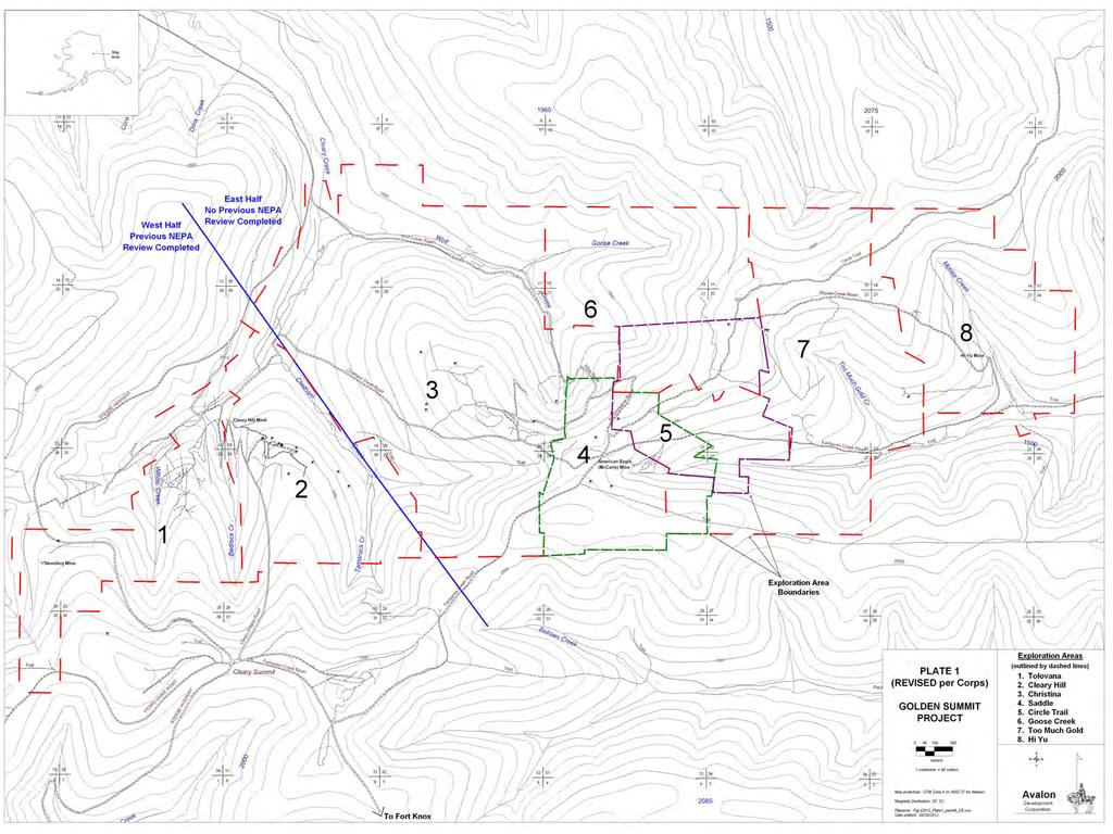
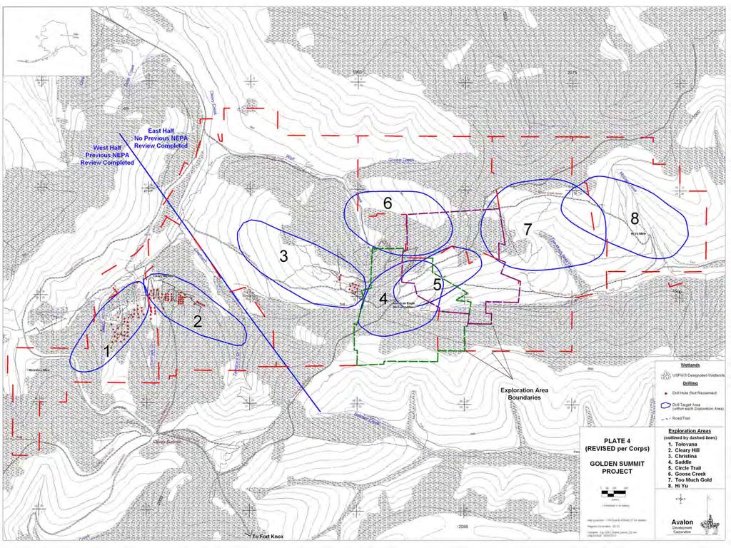
2 PROPOSED WORK: Anticipated exploration activities would be diamond core drilling using wheel, track, or skid-mounted drill rigs. Where possible, drilling would be conducted from existing roads and/or drilling pads, or on previously constructed and reclaimed drilling pads or access roads. Where existing infrastructure is not available, Freegold proposes to clear drill pads, (maximum of 50 feet in diameter), from which one or more holes would be drilled. Drill holes would average feet in depth with an average hole depth of approximately 750 feet. New access roads to support drilling would be required in some parts of the exploration area. Access roads would have a 12 wide footprint. The applicant requests a five year (5) time extension to extend exploration activities on the Tolovana-Cleary Hill exploration block on the western half of their Golden Summit project, (POA issued June 7, 2007). Applicant also proposes to expand exploration on the Christina Hi Yu exploration block on the eastern half of their Golden Summit project, (Sheet 1-11). Wetland impacts on the western half of the project are still covered under the original permit. Modification of the permit to include the eastern half would add an additional 15.8 acres of impacts to black spruce wetlands. Exploration activities include access roads, drill pads and drill holes. All work would be performed in accordance with the enclosed plan, (sheets 1-11), dated October 17, ADDITIONAL INFORMATION: In previous applications submitted on the Golden Summit project, the project has been separated into several exploration prospect areas to facilitate explanation of the proposed activities. These prospect names have been retained in this new application to maintain clarity and consistency. Tolovana-Cleary Hill exploration block western half of the Golden Summit Project: This part of the Fairbanks Mining District has seen extensive lode and placer gold mining since the early 1900 s. Exploration within several of the exploration areas was conducted between by previous companies. Disturbances from most of these activities were not reclaimed prior to Freegold s acquisition of Golden Summit in Freegold conducted additional exploration between 1994 and 1998 and completed all reclamation requirements before January 1, In 2007, an Individual Permit was issued to Freegold Recovery, Inc. USA, APMA 9726, to impact 33 acres of wetlands for exploration trenches, bulk sampling, access roads, and drill pads on the Tolovana-Cleary Hill exploration blocks, (West Half of Golden Summit Project). To date, 11.9 acres of wetlands have been impacted under this authorization. The applicant has requested a five year time extension for this work and an additional 14 acres of new wetland disturbance, bringing the total wetland impacts to 25.9, still within the original authorization. The proposed new wetland fills would occur on typical north-facing black spruce forest. No riparian wetland disturbance is proposed. The main streams draining this block include Cleary Creek and its tributaries Chatham, Bedrock, and Willow Creeks. The western edge of the Tolovana area is drained by the upper reaches of Little Eldorado Creek. 2
3 Unreclaimed Wetland Proposed Drill Pad Proposed Access Road Proposed Wetland All Wetland West-Half Prospect Unreclaimed All Cleary Hill - All Tolovana - All Totals Christina-Hi Yu exploration block - eastern half of the Golden Summit Project: This part of the Fairbanks Mining District has seen extensive lode and placer gold mining since the early 1900 s. Exploration within several of the exploration areas was conducted between by previous companies. Disturbances from most of these activities were reclaimed prior to Freegold s acquisition of Golden Summit in Freegold conducted additional exploration between 1994 and 1998 and completed all reclamation requirements before January 1, Three acres of reclamation liabilities currently exist on the Christina-Hi Yu exploration block. The applicant has requested a modification to the 2007 permit to include exploration in the Christina-Hi Yu block. Total disturbance for this block would be 31.5 acres of which 15.8 acres are in wetlands. Freegold states that approximately 50% of this drilling would be on previously undisturbed lands. The main streams draining this block include Cleary Creek and its tributaries Wolf and Chatham Creeks; Fairbanks Creek and its tributaries Too Much Gold and Moose Creeks; and Pilot and Captain Creeks which drain the northern edge of the claim area. The lower reaches of Captain Creek (outside the project area) is identified as a Chinook salmon rearing stream on the Alaska Department of Fish and Game website. Proposed Drill Pad Proposed Access Road Proposed Wetland All Wetland East-Half Prospect Unreclaimed Unreclaimed Wetland All Christina - All Circle Trail - All Goose Creek - All Hi Yu - All Saddle - All Too Much Gold - All Totals Reclamation: During initial disturbance, all humic material covering drill pads and/or access roads would be stockpiled in a separate but adjacent area, preferably the low-side of the site to allow this berm to act as a natural silt-fence for run-off from the excavation. All soil overburden would be stockpiled in a separate but adjacent area. All rock and rubble from bedrock excavation would be stockpiled in a different area. 3
4 Following completion of drilling at each drill hole, all drill holes would be plugged from termination depth to surface using a commercial hole plugging mixture. All surface casing, if used, would be removed prior to reclamation. All timber used to stabilize the rig would be removed and re-used. All refuse, drill supplies, and materials brought to site would be removed prior to reclamation of the site. Once planned work at a drill pad and/or access road has been completed, a back-hoe and/or crawler dozer would be used to backfill the disturbed area in the reverse order of excavation. Silt fences would be placed as appropriate to minimize impact to adjacent wetlands and streams. No artificial re-seeding is planned unless required. Culverts, if installed, would be removed. Historic RS2477 roads, Cleary Wagon Road, Bedrock Creek Road, Willow Creek Road, Chatham Creek Road, and Cleary Creek Road would be used for access but would not be reclaimed due to their historic nature and heavy use by third party recreationalists and mining claim owners. APPLICANT PROPOSED MITIGATION: The applicant proposes the following mitigation measures to avoid, minimize, and compensate for impacts to waters of the United States from activities involving discharges of dredged or fill material. a. Avoidance: Applicant s mineral exploration efforts are naturally concentrated in uplands. Wetlands and waters avoidance would include the following: 1. Occupying diamond core drilling sites in uplands. 2. No work would be planned in stream bottoms or streams. 3. Utilizing lined sumps to recycle drill fluids to prevent impacting waters of the United States (U.S.). 4. Utilizing existing water ponds for source water therefore eliminating excavation in wetlands. 5. Placing equipment and fuel supplies within containment systems to prevent release of petroleum based products into waters of the U.S. b. Minimization: Applicant anticipates disturbing hillside wetlands and plans to minimize impacts by 1. Drilling as many exploration drill holes as possible from existing, historic roads and trails. 2. Drilling multiple drill holes from a single drill pad and reducing pad footprint to minimum size for safe operations. 3. Excavating and utilizing pads in wetlands areas during the winter months. 4. Constructing access roads and drill pads such that sheet and channel erosion are reduced or eliminated. 5. Reclaiming all disturbed areas to as close to original contours as possible at the soonest date practicable. c. Compensatory Mitigation: The applicant proposes to pay an in-lieu fee as compensatory mitigation. WATER QUALITY CERTIFICATION: A permit for the described work will not be issued until a certification or waiver of certification, as required under Section 401 of the Clean Water Act (Public Law ), has been received from the Alaska Department of Environmental Conservation. 4
5 CULTURAL RESOURCES: The latest published version of the Alaska Heritage Resources Survey (AHRS) has been consulted for the presence or absence of historic properties, including those listed in or eligible for inclusion in the National Register of Historic Places. There are many unevaluated properties in the vicinity of the worksite. There is one eligible property in the vicinity of the worksite. It has been designated LIV-404, Hi-Yu Stamp Mill. Because it has been determined to be within the project area, a determination of effect will be made in consultation with the State Historic Preservation Officer (SHPO). Consultation of the AHRS constitutes the extent of cultural resource investigations by the District Commander at this time. Any comments SHPO may have concerning presently unknown archeological or historic data that may be lost or destroyed by work under the requested permit will be considered in our final assessment of the described work. SHPO was contacted via by Debby McAtee, on October 19, 2012 with a list providing all properties found within the mining claims, the area of potential effect. ENDANGERED SPECIES: NO EFFECT. No threatened or endangered species are known to use the project area. Therefore, no consultation with the U.S. Fish and Wildlife Service or the National Marine Fisheries Service is required. However, any comments they may have concerning endangered or threatened wildlife or plants or their critical habitat will be considered in our final assessment of the described work. ESSENTIAL FISH HABITAT: The Magnuson-Stevens Fishery Conservation and Management Act, as amended by the Sustainable Fisheries Act of 1996, requires all Federal agencies to consult with the NMFS on all actions, or proposed actions, permitted, funded, or undertaken by the agency, that may adversely affect Essential Fish Habitat (EFH). No EFH species are known to use the project area. The Alaska Department of Fish and Game s Fish Monitor Resource website was checked on October 22, The lower reaches of Captain Creek is identified as an anadromous stream for Chinook rearing. We have determined the described activity would not adversely affect EFH in the project area. TRIBAL CONSULTATION: The Alaska District fully supports tribal selfgovernance and government-to-government relations between Federally recognized Tribes and the Federal government. Tribes with protected rights or resources that could be significantly affected by a proposed Federal action (e.g., a permit decision) have the right to consult with the Alaska District on a government-to-government basis. Views of each Tribe regarding protected rights and resources will be accorded due consideration in this process. This Public Notice serves as notification to the Tribes within the area potentially affected by the proposed work and invites their participation in the Federal decision-making process regarding the protected Tribal right or resource. Consultation may be initiated by the affected Tribe upon written request to the District Commander during the public comment period. PUBLIC HEARING: Any person may request, in writing, within the comment period specified in this notice, that a public hearing be held to consider 5
6 this application. Requests for public hearings shall state, with particularity, reasons for holding a public hearing. EVALUATION: The decision whether to issue a permit will be based on an evaluation of the probable impacts, including cumulative impacts of the proposed activity and its intended use on the public interest. Evaluation of the probable impacts, which the proposed activity may have on the public interest, requires a careful weighing of all the factors that become relevant in each particular case. The benefits, which reasonably may be expected to accrue from the proposal, must be balanced against its reasonably foreseeable detriments. The outcome of the general balancing process would determine whether to authorize a proposal, and if so, the conditions under which it will be allowed to occur. The decision should reflect the national concern for both protection and utilization of important resources. All factors, which may be relevant to the proposal, must be considered including the cumulative effects thereof. Among those are conservation, economics, aesthetics, general environmental concerns, wetlands, cultural values, fish and wildlife values, flood hazards, floodplain values, land use, navigation, shore erosion and accretion, recreation, water supply and conservation, water quality, energy needs, safety, food and fiber production, mineral needs, considerations of property ownership, and, in general, the needs and welfare of the people. For activities involving 404 discharges, a permit will be denied if the discharge that would be authorized by such permit would not comply with the Environmental Protection Agency's 404(b)(l) guidelines. Subject to the preceding sentence and any other applicable guidelines or criteria (see Sections and 320.3), a permit will be granted unless the District Commander determines that it would be contrary to the public interest. The Corps of Engineers is soliciting comments from the public; Federal, State, and local agencies and officials; Indian Tribes; and other interested parties in order to consider and evaluate the impacts of this proposed activity. Any comments received will be considered by the Corps of Engineers to determine whether to issue, modify, condition or deny a permit for this proposal. To make this decision, comments are used to assess impacts on endangered species, historic properties, water quality, general environmental effects, and the other public interest factors listed above. Comments are used in the preparation of an Environmental Assessment and/or an Environmental Impact Statement pursuant to the National Environmental Policy Act. Comments are also used to determine the need for a public hearing and to determine the overall public interest of the proposed activity. AUTHORITY: This permit will be issued or denied under the following authority: (X) Discharge dredged or fill material into waters of the United States Section 404 Clean Water Act (33 U.S.C. 1344). Therefore, our public interest review will consider the guidelines set forth under Section 404(b) of the Clean Water Act (40 CFR 230). Project drawings and a Notice of Application for State Water Quality Certification are enclosed with this Public Notice. Enclosures District Commander U.S. Army, Corps of Engineers 6
7 SEAN PARNELL, GOVERNOR STATE OF ALASKA DEPT. OF ENVIRONMENTAL CONSERVATION DIVISION OF WATER 401 Certification Program Non-Point Source Water Pollution Control Program DEPARTMENT OF ENVIRONMENTAL CONSERVATION WQM/401 CERTIFICATION 555 CORDOVA STREET ANCHORAGE, ALASKA PHONE: (907) /FAX: (907) NOTICE OF APPLICATION FOR STATE WATER QUALITY CERTIFICATION Any applicant for a federal license or permit to conduct an activity that might result in a discharge into navigable waters, in accordance with Section 401 of the Clean Water Act of 1977 (PL95-217), also must apply for and obtain certification from the Alaska Department of Environmental Conservation that the discharge will comply with the Clean Water Act, the Alaska Water Quality Standards, and other applicable State laws. By agreement between the U.S. Army Corps of Engineers and the Department of Environmental Conservation, application for a Department of the Army permit to discharge dredged or fill material into navigable waters under Section 404 of the Clean Water Act also may serve as application for State Water Quality Certification. Notice is hereby given that the application for a Department of the Army Permit described in the Corps of Engineers Public Notice No. POA , Cleary and Fairbanks Creeks, serves as application for State Water Quality Certification from the Department of Environmental Conservation. After reviewing the application, the Department may certify there is reasonable assurance the activity, and any discharge that might result, will comply with the Clean Water Act, the Alaska Water Quality Standards, and other applicable State laws. The Department also may deny or waive certification. Any person desiring to comment on the project, with respect to Water Quality Certification, may submit written comments to the address above by the expiration date of the Corps of Engineer s Public Notice. 7

8 Western Half Tolovana-Cleary Hill Exploration Block Vicinity Map POA , Fairbanks Creek APMA 9726, Freegold Recovery Inc. Golden Summit Project 17 October 2012 Sheet 1 of 11 Eastern Half Christina-Hi Yu Exploration Block
9
10
11
12
13 50 MAX CLEARING LIMIT 5-10 ORGANIC LAYER BEDROCK ORIGINAL SLOPE 4 DEPTH 10 DIAMETER 5 + ORGANIC STOCKPILE ORGANIC MAT NOTES: CUT/FILL AREA DRILL RETURN SUMP (FOR RECYCLE) - DRILL PAD VARIES TO MAX OF 50 FEET DIAMETER. - WHERE APPLICABLE, TOPSOIL AND ORGANIC MATERIALS WILL BE STOCKPILED ON DOWNGRADIENT SLOPE TO MINIMIZE IMPACTS TO ADJACENT WETLANDS. - DURING RECLAMATION, DRILL PAD WILL BE RECONTOURED AND CAPPED WITH ORGANICS. IF AVAILABLE, CUT TREES WILL BE SCATTERED OVER THE RECONTOURED TRENCH TO PROMOTE REVEGETATION AND DISCOURAGE ACCESS. - DEPTH OF CUT AND FILL WILL DEPEND ON SIDE SLOPE ASSUME AVERAGE OF 2-FOOT CUT DEPTH ON UPSLOPE SIDE - AVERAGE PAD SIZE 50 DIAMETER AND COVERING 0.05 ACRES - DRILL WATER RECYCLE SUMP IS UNLINED AND AVERAGES 10 FEET IN DIAMETER AND 3-4 FEET DEEP, CONTAINING 12 CUBIC YARDS - DIESEL FUEL FOR DRILL RIG AND SUPPORT EQUIPMENT IS STORED IN EACH UNIT S ON-BOARD FUEL TANK. THIS FUEL IS REPLENSIHED FROM 100 GALLON TANKS IN DRILL SUPPORT PICKUP TRUCKS. NO OTHER FUEL STORAGE ON-SITE - RECLAMATION: DRILL PADS AND SUMP WILL BE RECONTOURED WITH BEDROCK AND SOIL USED TO MAKE PAD, THEN ORGANIC STOCKPILE WOULD BE DISTRIBUTED OVER AREA TO MITIGATE SHEET AND CHANNEL EROSION AND FOSTER REVEGETATION. Drill Pad Footprint Drill Rig Outline Golden Summit Project: Exploration Drill Pad Typical Section Drill Hole Plan View 50 Mud Sump Drainage ditch
14 20 MAX CLEARING LIMIT 5-10 ORGANIC LAYER BEDROCK 2 WORKING SURFACE (10 feet) CUT/FILL AREA (12 feet) ORGANIC STOCKPILE 5 + ORGANIC MAT DRAINAGE DITCH Plan View 20 NOTES: - ACCESS ROAD OPERATING SURFACE IS 12 FEET IN WIDTH. - FILL WILL BE EITHER EXCAVATED BEDROCK FROM CUT PORTION OF ROAD OR GRAVEL. - WHERE APPLICABLE, TOPSOIL AND ORGANIC MATERIALS WILL BE STOCKPILED ON DOWNGRADIENT SLOPE TO MINIMIZE IMPACTS TO ADJACENT WETLANDS. - DURING RECLAMATION, ACCESS ROADS WILL BE RECONTOURED AND CAPPED WITH ORGANICS. IF AVAILABLE, CUT TREES WILL BE SCATTERED OVER THE RECONTOURED TRENCH TO PROMOTE REVEGETATION AND DISCOURAGE ACCESS. - DEPTH OF CUT AND FILL WILL DEPEND ON SIDE SLOPE ASSUME AVERAGE OF 2-FOOT CUT DEPTH ON UPSLOPE SIDE. - RECLAMATION: ROADS WILL BE RECONTOURED WITH BEDROCK AND SOIL USED TO MAKE ROAD BED, THEN ORGANIC STOCKPILE WOULD BE DISTRIBUTED OVER AREA TO MITIGATE SHEET AND CHANNEL EROSION AND FOSTER REVEGETATION. Road DRAINAGE DITCHES Organic Stockpile Golden Summit Project: Exploration Access Road Typical Section
15 20 MAX CLEARING LIMIT WORKING SURFACE (10 feet) ORGANIC STOCKPILE ORGANIC LAYER BEDROCK ARMOR PLACED AROUND CULVERT CUT/FILL AREA (12 feet) CULVERT ORGANIC MAT Plan View 20 NOTES: - ACCESS ROAD OPERATING SURFACE IS 12 FEET IN WIDTH. - CULVERT WILL BE SIZED TO FIT THE DRAINAGE, USUALLY INCH DIAMETER CMP. - CULVERT WILL BE PLACED IN NATURAL DRAINAGE OR DITCH FLOW LINE. IF APPLICABLE, DOWNSLOPE ORGANIC STOCKPILE WILL BE NOTCHED TO ALLOW FLOW-THROUGH. - RECLAIMATION: CULVERTS WILL BE REMOVED, THEN ROAD WILL BE RECONTOURED WITH BEDROCK AND SOIL USED TO MAKE ROAD BED, THEN ORGANIC STOCKPILE WOULD BE DISTRIBUTED OVER AREA TO MITIGATE SHEET AND CHANNEL EROSION AND FOSTER REVEGETATION. CULVERT RIP-RAP Road Organic Stockpiles DRAINAGE DITCHES Golden Summit Project: Culvert Typical Section
16 50 MAX CLEARING LIMIT ORGANIC BACKFILL ORGANIC LAYER BEDROCK BEDROCK BACKFILL ORGANIC MAT NOTES: CUT/FILL AREA DRILL RETURN SUMP - DRILL PAD VARIES TO MAX OF 50 FEET DIAMETER. - WHERE APPLICABLE, TOPSOIL AND ORGANIC MATERIALS WILL BE STOCKPILED ON DOWNGRADIENT SLOPE TO MINIMIZE IMPACTS TO ADJACENT WETLANDS. - DURING RECLAMATION, DRILL PAD WILL BE RECONTOURED AND CAPPED WITH ORGANICS. IF AVAILABLE, CUT TREES WILL BE SCATTERED OVER THE RECONTOURED TRENCH TO PROMOTE REVEGETATION AND DISCOURAGE ACCESS. - DEPTH OF CUT AND FILL WILL DEPEND ON SIDE SLOPE ASSUME AVERAGE OF 2-FOOT CUT DEPTH ON UPSLOPE SIDE - AVERAGE PAD SIZE 50 DIAMETER AND COVERING 0.05 ACRES - DRILL WATER RECYCLE SUMP IS UNLINED AND AVERAGES 10 FEET IN DIAMETER AND 3-4 FEET DEEP, CONTAINING 12 CUBIC YARDS - DIESEL FUEL FOR DRILL RIG AND SUPPORT EQUIPMENT IS STORED IN EACH UNIT S ON-BOARD FUEL TANK. THIS FUEL IS REPLENSIHED FROM 100 GALLON TANKS IN DRILL SUPPORT PICKUP TRUCKS. NO OTHER FUEL STORAGE ON-SITE - RECLAMATION: DRILL PADS AND SUMP WILL BE RECONTOURED WITH BEDROCK AND SOIL USED TO MAKE PAD, THEN ORGANIC STOCKPILE WOULD BE DISTRIBUTED OVER AREA TO MITIGATE SHEET AND CHANNEL EROSION AND FOSTER REVEGETATION. Drill Pad Footprint Plan View 50 Golden Summit Project: Reclaimed Exploration Drill Pad Typical Section Mud Sump Organic Backfill
17 20 MAX CLEARING LIMIT ORGANIC BACKFILL ORGANIC LAYER BEDROCK BEDROCK ORGANIC MAT BACKFILL Plan View 20 NOTES: - ACCESS ROAD OPERATING SURFACE IS 12 FEET IN WIDTH. - FILL WILL BE EITHER EXCAVATED BEDROCK FROM CUT PORTION OF ROAD OR GRAVEL. - WHERE APPLICABLE, TOPSOIL AND ORGANIC MATERIALS WILL BE STOCKPILED ON DOWNGRADIENT SLOPE TO MINIMIZE IMPACTS TO ADJACENT WETLANDS. - DURING RECLAMATION, ACCESS ROADS WILL BE RECONTOURED AND CAPPED WITH ORGANICS. IF AVAILABLE, CUT TREES WILL BE SCATTERED OVER THE RECONTOURED TRENCH TO PROMOTE REVEGETATION AND DISCOURAGE ACCESS. - DEPTH OF CUT AND FILL WILL DEPEND ON SIDE SLOPE ASSUME AVERAGE OF 2-FOOT CUT DEPTH ON UPSLOPE SIDE. - RECLAMATION: ROADS WILL BE RECONTOURED WITH BEDROCK AND SOIL USED TO MAKE ROAD BED, THEN ORGANIC STOCKPILE WOULD BE DISTRIBUTED OVER AREA TO MITIGATE SHEET AND CHANNEL EROSION AND FOSTER REVEGETATION. Organic Backfill Golden Summit Project: Reclaimed Exploration Access Road Typical Section
18 20 MAX CLEARING LIMIT ORGANIC BACKFILL ORGANIC LAYER ORGANIC MAT BEDROCK CULVERT (Removed) Plan View 20 NOTES: - ACCESS ROAD OPERATING SURFACE IS 12 FEET IN WIDTH. - CULVERT WILL BE SIZED TO FIT THE DRAINAGE, USUALLY INCH DIAMETER CMP. - CULVERT WILL BE PLACED IN NATURAL DRAINAGE OR DITCH FLOW LINE. IF APPLICABLE, DOWNSLOPE ORGANIC STOCKPILE WILL BE NOTCHED TO ALLOW FLOW-THROUGH. - RECLAIMATION: CULVERTS WILL BE REMOVED, THEN ROAD WILL BE RECONTOURED WITH BEDROCK AND SOIL USED TO MAKE ROAD BED, THEN ORGANIC STOCKPILE WOULD BE DISTRIBUTED OVER AREA TO MITIGATE SHEET AND CHANNEL EROSION AND FOSTER REVEGETATION. Organic Backfill Golden Summit Project: Reclaimed Culvert Typical Section